Railyard Alternatives and I-280 Boulevard Feasibility Study. MTA Board Meeting May 6, 2014
|
|
|
- Andrea Waters
- 5 years ago
- Views:
Transcription


1 Railyard Alternatives and I-280 Boulevard Feasibility Study MTA Board Meeting May 6, 2014
 Caltrain Electrification High Speed")
2 Planned Infrastructure Major pieces of new infrastructure are planned including: Downtown Rail Extension (DTX) Caltrain Electrification High Speed Rail (HSR) 2
3 Planned Infrastructure - continued Desire for a holistic approach Interest in coordinating projects HSR and Caltrain projects could negatively affect surrounding neighborhoods Need to augment funding sources Need to accommodate the next generation of growth Need to improve the urban environment 3

")

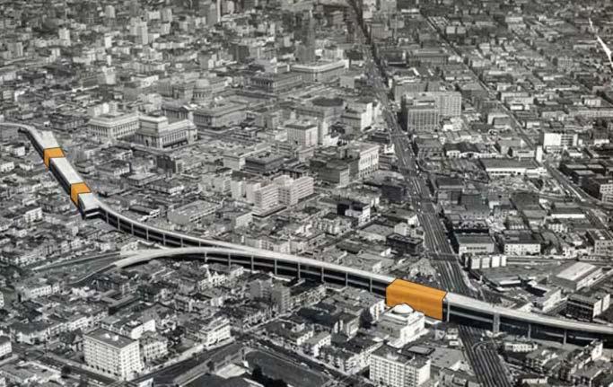
4 Barriers CHSRA Grade Separation (2010) I-280 Barrier Railyard Barrier 4
5 Goals of the Study Determine the best methods of construction for various projects Coordinated effort to improve urban environment Create opportunity to increase housing and job growth needs Determine cost and potential revenue sources 5
")
")


6 Background - History California High Speed Rail Authority (CHSRA) Transbay Transit Center (TTC) Downtown Rail Extension (DTX) Caltrain Electrification Anticipated Growth Local Plans Central SoMa Mission Bay/UCSF Eastern Neighborhoods 16 th Street Bus Rapid Transit Background 6

7 Overview of Proposed Contract Contract Feasibility Assessment Conceptual Analysis Alternatives Refinement of Alternatives Components 1. Boulevard I Independent DTX Value Engineering 3. Transbay Terminal Loop Track 4. Reconfiguration/relocation of 4 th /King Railyard 5. Placemaking and Development Opportunities 7


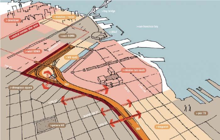
8 1. Boulevard I-280 Existing Conditions Railyards and I-280 freeway consume 24+ acres 1.2-mile barrier separates Mission Bay from SoMa, Showplace Square and Potrero Hill Only two crossings Mission Bay Drive 16 th Street Previous Studies Background 8

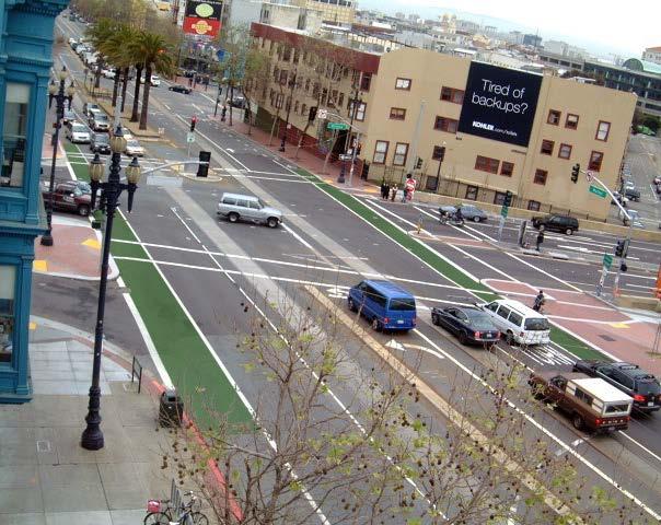
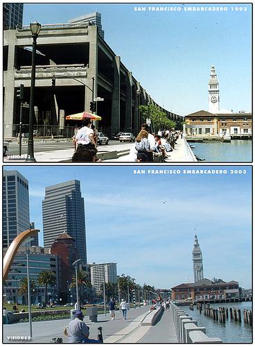
9 Other Freeway Boulevards Embarcadero Octavia 9


10 Panhandle Boulevard Proposal Maximum Development Boulevard Proposal Options Studied 10
11 11

12 1. Boulevard I-280 Anticipated Scope of Work Replace stub-end elevated freeway with surfaced urban boulevard Reconnect divided neighborhoods Determine the impacts and benefits associated with boulevarding 12

")
13 Cut-and-Cover Throat Structure Widens from three to six 2. DTX Value Engineering Study Mined Tunnel (sequential excavation method) Three tracks Open Trench Narrows from three to two tracks (includes tunnel stub for future grade separation ) Options Studied 13

14 2. DTX Value Engineering Anticipated Scope of Work Review alignment and construction methods for connecting HSR and Caltrain to TTC, to reduce costs. Build on existing options previously studied. Constraints to be tested include: Avoid major sewer infrastructure Avoid structures on pilings During construction: Maintain Caltrain operations Minimize disruption to local land uses Accommodate local circulation and regional traffic 14
15 3. Transbay Loop Track Anticipated Scope of Work Review and update previous loop track studies Assess technical and financial benefits/costs of including a loop track in the area 15

16 4. Reconfiguration/Relocation of Railyard Options for redevelopment: 1. Reconfigure railyards to a smaller footprint Allows for phased development as land becomes available 2. Construct deck over existing railyards Limited development potential Poor interface with street level 3. Relocate railyards Enable clean slate development 16

17 4. Reconfiguration/Relocation Options Options Studied Two of the possible options shown above 17

18 4. Reconfiguration/Relocation of Railyard Anticipated Scope of Work Determine needs at 4 th & King Determine area required to meet needs Look at alternative locations for additional storage Potential Phasing plan 18
 I-280")

19 5. Placemaking and Development Opportunities Railyard (20+ acres) I-280 Corridor (4+ acres) Re-evaluate adjacent parcels in the area New Revenue and Value Capture 19
 Generate revenue for Caltrain and other transportation improvements both capital and ongoing operating revenue Generate additional ridership")
20 Benefits of Improvement or Development of Background 4 th /King Area as Proposed Reconnect Neighborhoods - Integrate Mission Bay and Eastern Waterfront with rest of City Create new access and linkages in the area (pedestrian, bicycle, vehicular, etc) Generate revenue for Caltrain and other transportation improvements both capital and ongoing operating revenue Generate additional ridership from Transit Oriented Development (TOD) Help meet SF s Regional Housing Needs Allocation (RHNA) and Plan Bay Area targets for transit-served priority development areas Plan for sea level rise and climate change vulnerability 20

21 5. Placemaking & Development Opportunities Anticipated Scope of Work For available parcels of land, determine: Potential land use/development scenarios Height/Bulk and Zoning Scenarios 21
22 Public Involvement Throughout the project (total of 8 meetings 4 rounds: Phase I and Phase II) Focused meetings Advisory Committees Technical Advisory Committee Citizen Advisory Committee CCSF Commission/Board updates Outreach to identified stakeholders/community groups 22
23 Schedule Phase Date RFP issued by City January 2014 Contract Start Date May 2014 (anticipated) Phase I Feasibility Assessment 6-9 months Phase II Alternatives and Refinement months Completion of this contract December 2015 June 2016 Follow-on Phases Phase III Preferred Alternative Phase IV Environmental Clearances Phase V - Implementation Anticipated Dates months 18 months 4 years (could be semi-concurrent with Phase III) As money and priorities allow 23


24 Questions? For more information on this project Contact: Susan Gygi, PE
The Role of Cities in Planning Transportation Megaprojects
 The Role of Cities in Planning Transportation Megaprojects SPUR Oakland, November 28, 2018 + Elizabeth Deakin / UC Berkeley + Eric Eidlin / City of San Jose + Doug Johnson / City of San Francisco The Role
Atlanta BeltLine Corridor Environmental Study. Scoping Meeting August 2008
 Atlanta BeltLine Corridor Environmental Study Scoping Meeting August 2008 What Will We Be Discussing Today? Study Overview - How Did We Get Here? - What Is the Study About? - Who Is Involved? - Where Is
I-84 Hartford Project Open Planning Studio #12. April 25, 2017
 I-84 Hartford Project Open Planning Studio #12 April 25, 2017 Meeting Agenda 1. I-84 Hartford Project alternatives update 2. Multimodal station area planning 3. I-84 / I-91 Interchange Study coordination
Southern Gateway Project and Public Green
 Southern Gateway Project and Public Green Transportation and Trinity River Project Committee May 23, 2016 Purpose of Presentation Provide the history and an overview of the Southern Gateway Project (SGP)
REVIEW AND EVALUATION OF REGIONAL LAND USE
 REVIEW AND EVALUATION OF REGIONAL LAND USE AND TRANSPORTATION SCENARIOS #220831 Environmental Justice Task Force October 7, 2014 VISION 2050 Process Development of Guiding Vision for Land Use and Transportation
Transbay Folsom Streetscape Project 2 nd Street to Spear Street Community Update July 16, 2015
 Transbay Folsom Streetscape Project 2 nd Street to Spear Street Community Update July 16, 2015 A2 Agenda Welcome and introductions Project history and goals Project overview and next steps Questions and
PLAN ELEMENTS WORKSHOP. April 5, 2016
 PLAN ELEMENTS WORKSHOP April 5, 2016 needs more housing. But there is no one-size fits-all solution. Every neighborhood has its own character. In some places, density is not only appropriate it is badly
Pier 70 Master Plan. Port of San Francisco
 Project Overview Develop a Preferred Master Plan for a 65-acre Brownfield site Adaptive reuse of historic structures and new development that reconciles numerous regulatory, economic, maritime, historic
38 Queen s University Campus Master Plan Part 1
 38 Queen s University Campus Master Plan Part 1 46 The Campus at the City Scale Chapter 4 The Campus at the City Scale 39 Queen s is an urban University centrally located in Kingston. Decisions made by
José Campos Manager of Planning and Design Review SPUR San José Symposium October 12, 2018
 1 Transbay: Freeways to New Ways José Campos Manager of Planning and Design Review SPUR San José Symposium October 12, 2018 2 Transbay freeway land pre-1989 3 1989 Loma Prieta Earthquake 4 TRANSBAY c.
Tyvola & Archdale Transit Station Area Plan. May 15, 2008
 Tyvola & Archdale Transit Station Area Plan First Public Meeting May 15, 2008 Presentation Outline 1. Purpose and Process 2. Station Area Overview 3. Plan Recommendations Vision Land Use Transportation
RESOLUTION NO. R Refining the route, profile and stations for the Downtown Redmond Link Extension
 RESOLUTION NO. R2018-32 Refining the route, profile and stations for the Downtown Redmond Link Extension MEETING: DATE: TYPE OF ACTION: STAFF CONTACT: Capital Committee Board PROPOSED ACTION 09/13/2018
Community Meeting #1: Project Kick Off
 Community Meeting #1: Project Kick Off November 17, 2015 What are 3 things you like about Downtown Gilroy that you want to hold onto in the future? Please write them down and share with us! Tonight s Meeting
City of Tacoma Planning and Development Services
 Agenda Item E-1 City of Tacoma Planning and Development Services To: Planning Commission From: Elliott Barnett, Planning Services Division Subject: Tacoma Mall Regional Center Subarea Plan and EIS Meeting
Tysons Circulator Study: Process and Preliminary Results Summary. March 2012
 Tysons Circulator Study: Process and Preliminary Results Summary March 2012 Background: 1. The Comprehensive Plan for the Tysons Corner Urban Center calls for a System of Circulators in Tysons Corner to:
A. WHAT IS A GENERAL PLAN?
 I. Introduction A. WHAT IS A GENERAL PLAN? A general plan is the planning guideline for the future of a city. It contains goals and policies which regulate urban development, the protection of the natural
Station Area Plan Introduction & Draft Alternatives Review
 Station Area Plan Introduction & Draft Alternatives Review City Council Meeting - February 22, 2016 Project Background: California High-Speed Rail San Jose to San Fernando Valley Segment CHSRA will select
DRAFT Civic Center Station Area Plan. Executive Summary
 DRAFT Civic Center Station Area Plan Executive Summary This project is funded in part through the Metropolitan Transportation Commission s Station Area Planning Program. The preparation of this report
EXPO LINE COMMUNITY WORKSHOPS NOVEMBER 27 TH & DECEMBER 3 RD Los Angeles Department of City Planning
 EXPO LINE COMMUNITY WORKSHOPS NOVEMBER 27 TH & DECEMBER 3 RD 2012 Los Angeles Department of City Planning Agenda for Tonight Open House 6:00 to 6:15pm Presentation and Questions 6:15 to 6:50 Small Group
Relief Line Project Assessment
 Relief Line Project Assessment Stakeholder Advisory Meeting #4 May 30, 2016 Tonight s Meeting PURPOSE To present and discuss: Results of the evaluation of potential alignments Emerging preferred alignment
Tyvola & Archdale Transit Station Area Plan. June 5, 2008
 Tyvola & Archdale Transit Station Area Plan Second Public Meeting June 5, 2008 Presentation Outline 1. Purpose and Process 2. Station Area Overview 3. Plan Recommendations 4. Comments Received and Proposed
Seattle Transit Master Plan
 Seattle Transit Master Plan Seattle City Council Transportation Committee Briefing May 10, 2011 Seattle Department of Transportation Presentation Outline Review of project schedule and goals Review of
S C O P E O F W O R K A P R I L
 white flint 2 sector plan S C O P E O F W O R K A P R I L 2 0 1 2 MONTGOMERY COUNTY PLANNING DEPARTMENT M-NCPPC MontgomeryPlanning.org 1 white flint 2 sector plan Scope of Work abstract This scope of work
Honorable Members of the Mobility Solutions, Infrastructure and Sustainability Committee
 Memorandum DATE January 23, 2019 CITY OF DALLAS TO Honorable Members of the Mobility Solutions, Infrastructure and Sustainability Committee SUBJECT I-30 East Project Update On Monday, January 28, 2019,
Project Update. Hillsborough County 2045 Population and Employment Projections and Allocations. Board of County Commissioners February 13, 2018
 Hillsborough County 2045 Population and Employment Projections and Allocations Project Update Board of County Commissioners February 13, 2018 What will Hillsborough County look like in 25 years? Working
SAN RAFAEL GENERAL PLAN 2040 INTRODUCTION AND OVERVIEW
 SAN RAFAEL GENERAL PLAN 2040 INTRODUCTION AND OVERVIEW Steering Committee Presentation February 14, 2018 Purpose of General Plan Guide land use and development decisions Coordinate transportation, infrastructure,
Lake Oswego to Portland Transit Project. Lessons Learned. John Cullerton Senior Project Manager, URS 2012 APTA/TRB Light Rail Conference
 Lake Oswego to Portland Transit Project Lessons Learned John Cullerton Senior Project Manager, URS 2012 APTA/TRB Light Rail Conference Overview Project Location and Context Corridor History and Project
Northwest Rail Corridor and US 36 BRT Development Oriented Transit Analysis 4.4 STATION AREA FINDINGS
 4.4 STATION AREA FINDINGS Each station is different, and each one requires a separate set of recommendations based on the vision for the site. This section outlines an initial TOD strategy and recommendations
Memorandum CITY OF DALLAS
 Memorandum DATE September 23, 2016 CITY OF DALLAS TO The Honorable Members of the Transportation and Trinity River Project Committee: Lee M. Kleinman (Chair), Deputy Mayor Pro Tem Erik Wilson (Vice-Chair),
Scope of Services. River Oaks Boulevard (SH 183) Corridor Master Plan
 Corridor Master Plan") Scope of Services River Oaks Boulevard (SH 183) Corridor Master Plan PROJECT AREA The project area consists of the River Oaks Boulevard (SH 183) corridor bounded by SH 199 at the northern end and the Trinity
Scope of Services River Oaks Boulevard (SH 183) Corridor Master Plan PROJECT AREA The project area consists of the River Oaks Boulevard (SH 183) corridor bounded by SH 199 at the northern end and the Trinity
Atlanta BeltLine, Inc. Pathways to Urban Sustainability
 Atlanta BeltLine, Inc. Pathways to Urban Sustainability September 30, 2010 WHAT IS THE ATLANTA BELTLINE? Transit 22-mile loop Parks 1300 + new acres Trails 33 miles Jobs & Economic Development 20 areas,
This Review Is Divided Into Two Phases:
 Semiahmoo Town Centre Review The purpose of this review: To review the Semiahmoo Town Centre Concept Plan, originally approved in 1993, to ensure that this centre will continue to serve the needs of South
The transportation system in a community is an
 7 TRANSPORTATION The transportation system in a community is an important factor contributing to the quality of life of the residents. Without a sound transportation system to bring both goods and patrons
BeltLine Corridor Environmental Study
 BeltLine Corridor Environmental Study Citywide Conversation on Transit and Trails April 2, 2009 Agenda & Introductions Introductions Environmental Study Process Overview of the BeltLine Project BeltLine
TOWN COUNCIL / PLANNING COMMISSION
 Workshop #3 TOWN COUNCIL / PLANNING COMMISSION January 20, 2011 Consultant Team In Attendance Tonight BMS Design Group Nevada City and San Francisco Michael Smiley, AICP, ASLA Partner-in-Charge Nancy L.
Coordinated Transit Planning in Toronto SmartTrack GO RER Scarborough Relief Line Waterfront Transit
 Coordinated Transit Planning in Toronto SmartTrack GO RER Scarborough Relief Line Waterfront Transit Public Information Centres February 2016 Transportation Planning Section City Planning Division Toronto
Public Open House. Overview of the Downtown Plan Official Plan Amendment April 23, 2018
 Public Open House Overview of the Downtown Plan Official Plan Amendment April 23, 2018 1 A 25-Year Plan for Downtown To ensure growth contributes positively to Toronto s Downtown as a great place to live,
Multimodal Station Planning Working Session Rebuilding a Better I-84 in Hartford. August 10, 2017
 Multimodal Station Planning Working Session Rebuilding a Better I-84 in Hartford August 10, 2017 Station Urban Design Principles + Guidelines Station Urban Design Principles + Guidelines The station should
Shift Rapid Transit Public Participation Meeting May 3, 2017
 Shift Rapid Transit Public Participation Meeting May 3, 2017 Shift Rapid Transit Initiative Largest infrastructure project in the city s history. Rapid Transit initiative will transform London s public
Welcome. Green Line LRT. Beltline Alignment Options. Stay engaged! Follow the Green Line story at calgary.ca/greenline
 Welcome Green Line LRT Beltline Alignment Options Stay engaged! Follow the Green Line story at calgary.ca/greenline Green Line LRT Why are we here? Our Challenge Determine the best alignment in the Beltline.
Isabel Neighborhood Plan: Alternatives
 Isabel Neighborhood Plan: Alternatives Presented by: Lori Parks, Associate Planner February 2, 2015 Agenda 1. Background on BART to Livermore 2. Isabel Neighborhood Plan 3. Alternative Scenarios 4. General
Goals for Tonight s Meeting
 South Anthony Boulevard Railroad Grade Separation Study Report to Community November 30, 2011 Andorfer Commons Theatre Indiana Tech University Goals for Tonight s Meeting Recap of the meeting from last
Route 110 Alternatives Analysis
 Route 110 Alternatives Analysis Public Meeting #1 December 15, 2014 Source: Town of Babylon Agenda Welcome/Introduction Hon. Antonio A. Martinez Deputy Supervisor, Town of Babylon Update on East Farmingdale
1.0 Circulation Element
 5/9/18 1.0 Circulation Element 1.1 Introduction As growth and development occur in Apache County, enhancements to its circulation system will be necessary. With time, more roads will be paved and air and
John M. Fleming Managing Director, Planning and City Planner. Old East Village Dundas Street Corridor Secondary Plan Draft Terms of Reference
 Report to Planning and Environment Committee To: From: Subject: Chair and Members Planning & Environment Committee John M. Fleming Managing Director, Planning and City Planner Old East Village Dundas Street
Chapter 1.0 Introduction
 Chapter 1.0 Introduction 1.1 Background The North Metro commuter rail line is part of the RTD FasTracks regional transit system expansion program to build more than 100 miles of rail transit throughout
International Blvd. TOD Plan Public Workshop #1
 International Blvd. TOD Plan Public Workshop #1 Add photos or project images September 21 and 22, 2010 Workshop Purpose Introduce the public to the Project Review and discuss the existing conditions analysis
Physical Connectivity Do not have structures that physically divide the community more than it is divided today
 SECTION 0 & 1 SAN FRANCISCO ISSUES Caltrain & High Speed Rail service/stations Location of SF terminus (TTC and/or 4 th & King) and alignment must make sense from user perspective/greater ridership, and
Tony Garcia, City-County Planning Commission & Beth Alden, Hillsborough MPO
 Tony Garcia, City-County Planning Commission & Beth Alden, Hillsborough MPO TOD Defined A compact neighborhood with housing, jobs and neighborhood services within easy walking distance of a transit station
Eastside Transit Corridor Phase 2 Technical Study Update Community Outreach Meeting February 2017
 Eastside Transit Corridor Phase 2 Technical Study Update Community Outreach Meeting February 2017 Purpose of Tonight s Meeting Recap of Board motion (2014) and technical study process Provide update on
Introduction and Overview
 Introduction and Overview Articulate local values and priorities Guide land use and development decisions Coordinate transportation, infrastructure, and City services with expected growth and available
City of Hermosa Beach Administrative Policy #
 City of Hermosa Beach Administrative Policy # SUBJECT: Living Streets Policy Date: Approved by: City Council Authority: Public Works Department & Community Development Department Mayor, PURPOSE The City
Northwest commuter rail station US 36 BRT. Westminster Station
 Northwest commuter rail station Westminster Station US 36 BRT Westminster Center US 36 & Church Ranch Broomfield Flatiron/96 th St. US 36 & McCaslin Table Mesa Boulder Junction 13-month effort that will
Note: Red text denotes additions/ changes from Dec 23, 2009 draft Page 1 of 12
 1. Concern noise/vibration levels generated by project will impact quality of life of people living in proximity to project. 1.1 Project should not create more noise/vibration than there is today 1.2 Vibration
Dallas CBD Second Light Rail Alignment (D2)
") Dallas CBD Second Light Rail Alignment (D2) Subway Project Refinement Public Meetings January 19, 2017 Discussion Items Background Schedule Public/Stakeholder Involvement Subway Construction Overview Potential
Dallas CBD Second Light Rail Alignment (D2) Subway Project Refinement Public Meetings January 19, 2017 Discussion Items Background Schedule Public/Stakeholder Involvement Subway Construction Overview Potential
Union Station Master Plan Task 3 Update
 Union Station Master Plan Task 3 Update June 18, 2014 1 2 3 4 5 6 7 8 9 10 11 12 13 14 15 16 17 18 19 20 21 22 23 24 25 26 27 2012 2013 2014 A S O N D J F M A M J J A S O N D J F M A M J J A S O Task 1`
Mississippi Skyway Preliminary Engineering Report
 EXECUTIVE SUMMARY Mississippi Skyway Preliminary Engineering Report CITY OF RAMSEY, MINNESOTA DECEMBER 2014 City of RAMSEY EXECUTIVE SUMMARY Project Need and Intent The Mississippi Skyway pedestrian bridge
Evaluation Criteria. Detailed Evaluation Criteria
 Evaluation Criteria Detailed Evaluation Criteria Community Well-being A safe and socially inclusive service that improves access to key community destinations and provides transportation choices for Calgarians.
Promoting Economic Development Through Upfront SEPA Review: Lessons from South Downtown Tacoma
 Promoting Economic Development Through Upfront SEPA Review: Lessons from South Downtown Tacoma 1 This session will focus on the City of Tacoma s South Downtown Subarea Plan and associated Non-Project SEPA
Fifth and Detroit Street Design May 2017 Capital Improvements Committee. DOWNTOWN Street Design
 1 Fifth and Detroit Street Design May 2017 Capital Improvements Committee Agenda 2 Review Street Configuration Prior Meeting Review Outreach Synopsis Functional Street Design Refinements Curb Edge, Turning
Link Union Station (Link US) Project Open House September 26, 2018
 Project Open House September 26, 2018") Link Union Station (Link US) Project Open House September 26, 2018 Major Project Components 1. New rail communication, signals, and tracks 2. New run-through tracks over US-101 and new loop track 3. New
Link Union Station (Link US) Project Open House September 26, 2018 Major Project Components 1. New rail communication, signals, and tracks 2. New run-through tracks over US-101 and new loop track 3. New
TONIGHT S PURPOSE INFORMATION SESSION CANORA & WEST JASPER PLACE SIDE STREETS CONCEPT PLANNING STUDY. Share draft side streets concept plan
 TONIGHT S PURPOSE Share draft side streets concept plan INFORMATION SESSION Share information and answer questions Tuesday, December 1, 2015 Drop-In 5:30 8:00 PM West Jasper/Sherwood Community Hall TONIGHT
Informational Presentation JULIE CHRISTIENSEN DP-NWP GBD 29 JUNE 2016
 Informational Presentation JULIE CHRISTIENSEN DP-NWP GBD 29 JUNE 2016 TODAY S TOPICS 1. Public Realm Plan Goals & Outcomes 2. Project Identification & Polling 3. Current Capital Projects 4. Early Implementation
Community Meeting #2.1
 Community Meeting #2.1 Thursday, October 20, 2016, 7:00 p.m. to 9:00 p.m. Eliot Elementary School, 475 Old Gilroy Street, Gilroy, CA 95020 Meeting Summary The City of Gilroy held its third community meeting
TRANSPORTATION ELEMENT GOALS, OBJECTIVES, AND POLICIES
 TRANSPORTATION ELEMENT GOALS, OBJECTIVES, AND POLICIES GOAL 2 The City shall provide a safe, convenient, effective, and energy efficient multimodal transportation system which is coordinated with the Future
Gold Line Bus Rapid Transit Transit Oriented Development (BRTOD) Helmo Station Area Plan
 Helmo Station Area Plan") Appendix F Gold Line Bus Rapid Transit Transit Oriented Development (BRTOD) Helmo Station Area Plan Introduction and Purpose of the Plan The Gold Line Bus Rapid Transit facility is an eleven-mile dedicated
Appendix F Gold Line Bus Rapid Transit Transit Oriented Development (BRTOD) Helmo Station Area Plan Introduction and Purpose of the Plan The Gold Line Bus Rapid Transit facility is an eleven-mile dedicated
Phase I Redevelopment Plan. First Community Meeting
 Hoboken Terminal and Yard Phase I Redevelopment Plan First Community Meeting May 31, 2011 One Hudson Place Phase I Redevelopment Plan Redevelopment Plan First Community Meeting Agenda 1. Redevelopment
III. Design Principles
 III. Design Principles The design of Bay Meadows Phase II has been guided by a series of Urban Design Principles. These principles, informed by consultant site analysis, City staff recommendations, and
CENTRAL ESTUARY PLAN AVISION FOR OAKLAND S WATERFRONT
 Central Estuary Plan A VISION FOR OAKLAND S WATERFRONT Specific Plan and Environmental Assessment Presentation to the Parks and Recreation Advisory Commission December 9, 2009 This Afternoon s Presentation
SW Ecodistrict A VISION PLAN FOR A MORE SUSTAINABLE FUTURE June 25, 2013
 Urban Land Institute The Past, Present and Future of Sustainable Urbanism in Southwest DC SW Ecodistrict A VISION PLAN FOR A MORE SUSTAINABLE FUTURE June 25, 2013 Study Area The National Mall DOE FAA FAA
Dallas CBD Second Light Rail Alignment (D2)
") Dallas CBD Second Light Rail Alignment (D2) Subway Project Refinement City of Dallas Transportation and Trinity River Project Committee February 13, 2017 Discussion Items Background Schedule Public/Stakeholder
Dallas CBD Second Light Rail Alignment (D2) Subway Project Refinement City of Dallas Transportation and Trinity River Project Committee February 13, 2017 Discussion Items Background Schedule Public/Stakeholder
East Corridor Final Environmental Impact Statement
 East Corridor Final Environmental Impact Statement Alternatives Considered Operating Plan The requirements for opening day operations versus year 2030 are based on ridership and operations. Opening day
Metro Orange Line Extension Four Years Early and $61 Million Under Budget
 White Paper: Metro Orange Line Extension Four Years Early and $61 Million Under Budget July 2013 Innovation for better mobility Metro Orange Line Extension Iteris, Inc. was the prime consultant leading
Rezoning Transportation Analysis Petition Number: General Location Identifier:
 From: Kelsie Anderson, PE Kelsie.Anderson@charlottenc.gov 704-432-5492 Staff Reviewer: Kory Hedrick, PE, PMP Khedrick@charlottenc.gov 704-432-6511 CDOT s review of this rezoning petition is intended to
SAN FRANCISCO PLANNING DEPARTMENT
 PLANNING DEPARTMENT Certificate of Determination EXEMPTION FROM ENVIRONMENTAL REVIEW Case No.: Project Address: Zoning: UMU (Urban Mixed Use) Zoning District 68-X Height and Bulk District Life Science
SH 199 Corridor Master Plan. Community Meeting No. 2 May 31, 2017
 Community Meeting No. 2 May 31, 2017 Transportation Projects On or Near SH 199 SH 199 from 0.3 miles south of FM 1886 to south end of Lake Worth bridge Construct freeway mainlanes and frontage roads 10-Year
South King County High Capacity Transit Corridor Report. Figure Other Infrastructure
 South King County High Capacity Transit Corridor Report Figure 3-10. Other Infrastructure 30 Shorelines and Critical Areas The corridor is framed by three major water bodies: Puget Sound to the west, Elliott
Institutional Master Plan The Arnold Arboretum of Harvard University
 Institutional Master Plan The Arnold Arboretum of Harvard University Submitted to: Boston Redevelopment Authority One City Hall Square Boston, MA 02201 Submitted by: The Arnold Arboretum of Harvard University
Hillsborough County MPO Transit Study. Citizens Team Workshop Wednesday, February 28 th, 2006 Hillsborough Community College - Brandon
 Hillsborough County MPO Transit Study Citizens Team Workshop Wednesday, February 28 th, 2006 Hillsborough Community College - Brandon What is the MPO Transit Study? An effort to look at the full range
TOD 101 CREATING LIVABLE COMMUNITIES WITH TRANSIT
 1 CREATING LIVABLE COMMUNITIES WITH TRANSIT What are transit Centered Communities? Benefits of Partnerships to Support and Implement What You Will Learn Portland s Pearl District Your Trainers Today Catherine
Attachment D Eastside Transit Corridor Phase 2 Technical Study Route Options Screening Analysis and Community Outreach Executive Summary April 2017
 Attachment D Eastside Transit Corridor Phase 2 Technical Study Route Options Screening Analysis and Community Outreach Executive Summary April 2017 Technical Study Scope Nov 2014: Board-directed Technical
master plan of highways bus rapid transit amendment
 Scope of Work master plan of highways bus rapid transit amendment September 2011 Montgomery County Planning Department M-NCPPC MontgomeryPlanning.org 1 Scope of Work master plan of highways bus rapid transit
Future Proposed Development
 Future Proposed Development on and around Link light rail s Capitol Hill Station Meeting September 24, 2012 Tonight s Agenda 6:00 pm Open House 6:30 pm Introductions Richard Conlin, City of Seattle Councilmember/Sound
Title slide..poughkeepsie Planning Initiatives POUGHKEEPSIE PLANNING INITIATIVES
 Title slide..poughkeepsie Planning Initiatives Overview Revitalization Projects Waterfront Redevelopment Strategy Local Waterfront Revitalization Program Update Kaal Rock Connector Fallkill Creek Plan
CHAPTER 1. Ms. Guajardo s Class - Central Elementary CH 1 1
 INTRODUCTION CHAPTER 1 Ms. Guajardo s Class - Central Elementary CH 1 1 1.1 SETTING South Centre City is a linear corridor south of Downtown Escondido paralleling Centre City Parkway and South Escondido
Windsor Locks Transit-Oriented Development Planning Grant Request. Project Background
 Windsor Locks Transit-Oriented Development Planning Grant Request Project Background Downtown Windsor Locks runs along Main Street in the vicinity of the intersection of Routes 159 and 140. The current
Stafford County Strategic Plans
 Stafford County Strategic s Strategic Department Description Date Adopted Board of Supervisors Priorities Fiscal Responsibility Education Public Safety Infrastructure Economic Development Service Excellence
Developer s Program. The Station at East 54
 Developer s Program The Station at East 54 Existing Conditions The Station at East 54 is proposed for a 1.12 acre site at the northeast corner of Hamilton Road and Prestwick Road, tucked between the East
Making Transit Oriented Development Work For Boonton, NJ
 Making Transit Oriented Development Work For Boonton, NJ Bloustein School of Planning and Public Policy Studio Dan Burton Loannie Dao Webster Slater Brandon Williams Ian Watson Maria Laham Nicola Mammes
JANUARY 19, 2011 CENTRAL AVENUE-METRO BLUE LINE TRANSIT-ORIENTED DEVELOPMENT IMPLEMENTATION PROJECT COMMUNITY FORUM
 CENTRAL AVENUE-METRO BLUE LINE TRANSIT-ORIENTED DEVELOPMENT IMPLEMENTATION PROJECT COMMUNITY FORUM JANUARY 19, 2011 THE MARYLAND-NATIONAL CAPITAL PARK AND PLANNING COMMISSION PRINCE GEORGE S COUNTY PLANNING
Knoxville Area Transit (KAT) Transit Development Plan Corridor Analysis
 Transit Development Plan Corridor Analysis") Knoxville Area Transit (KAT) Transit Development Plan Submitted to: Knoxville-Knox County Metropolitan Planning Commission Submitted by: PB Americas, Inc. Under contract to: The Corradino Group, Inc. October
Knoxville Area Transit (KAT) Transit Development Plan Submitted to: Knoxville-Knox County Metropolitan Planning Commission Submitted by: PB Americas, Inc. Under contract to: The Corradino Group, Inc. October
CHARLES PUTMAN CHARLES PUTMAN AND ASSOCIATES, INC
 MEMORANDUM CHARLES PUTMAN & ASSOCIATES, INC. LAND DEVELOPMENT CONSULTANTS PLANNING ZONING PERMITTING 4722 NW Boca Raton Boulevard, Suite C-106 Boca Raton, Florida 33431 Phone: 561/994-6411 FAX: 561/994-0447
CITY S GOALS DRIVE MODE CHOICE IN WINSTON-SALEM, NC
 CITY S GOALS DRIVE MODE CHOICE IN WINSTON-SALEM, NC Taiwo Jaiyeoba HDR, Transit Principal, Atlanta, GA Claire Brinkley HDR, Transit Planner, Charlotte, NC AGENDA 1. Project Background 2. Project Process
3.4.5 Roadway System and Infrastructure Phase I (Project) Roadway System Components E Street Extension (Phase I).
 Roadway System Components E Street Extension (Phase I).") 3.4.5 Roadway System and Infrastructure Roadway demolition, road improvements, roadway realignments, and construction of new roads, as well as utility infrastructure improvements, transit, as well as pedestrian
3.4.5 Roadway System and Infrastructure Roadway demolition, road improvements, roadway realignments, and construction of new roads, as well as utility infrastructure improvements, transit, as well as pedestrian
M E M O R A N D U M. DATE: July 19, Patrick D. O Keeffe, City Manager. Economic Development & Housing
 M E M O R A N D U M DATE: July 19, 2011 TO: FROM: Patrick D. O Keeffe, City Manager Economic Development & Housing SUBJECT: Resolution of the City Council of the City of Emeryville Approving the Application
Silver Line CPAM UPDATE. Transportation and Land Use Committee October 14, 2016
 Silver Line CPAM UPDATE Transportation and Land Use Committee October 14, 2016 Purpose Recap Project History and Map Changes Provide Overview of CPAM Components Discuss Transportation Impacts Discuss Fiscal
CITY OF VAUGHAN EXTRACT FROM COUNCIL MEETING MINUTES OF NOVEMBER 15, 2016
 Item 11, Report No. 38, of the Committee of the Whole, which was adopted without amendment by the Council of the City of Vaughan on November 15, 2016. Regional Councillor Di Biase declared an interest
The Emerging Language of Highway Removals
 The Emerging Language of Highway Removals This page intentionally left blank. Introduction The Interstate Highway System, comprised of more than 46,876 miles of highways, provides connections to population
Citizen Comment Staff Response Staff Recommended Revision Planning Committee
 Citizen Comment Staff Response Staff Recommended Revision Planning Committee Area No. 1: Owner desires retail land uses. Area No. 1a: Owner of two small parcels adjacent to Area No. 1 desires retail land
Re: Alameda Point Update Review and Comment on SunCal s September 19, 2008 Development Concept
 Alameda Reuse and Redevelopment Authority Memorandum ITEM 10-A To: From: Honorable Chair and Members of the Alameda Reuse and Redevelopment Authority Debra Kurita Executive Director Date: November 5, 2008