APPENDIX 4 NEWBURY TOWNSHIP TOWN CENTER MASTER PLAN
|
|
|
- Lora French
- 5 years ago
- Views:
Transcription

1 APPENDIX 4 NEWBURY TOWNSHIP TOWN CENTER MASTER PLAN Prepared by the Urban Design Center of Northeast Ohio September, 2008 Newbury Township Land Use Plan A4-1


2 INDEX Page No. 1 Newbury Township Town Center Master Plan A4-3 2 Connection and Development Potential A Phase I Development Option 1 A4-6 Option 2 A4-8 Option 3 A Pedestrian Enhancements A Comprehensive Streetscape Enhancements A Achieving Appropriate Design A4-12 Prepared for Chagrin River Watershed Partners, Inc Erie Street, Suite 203 Willoughby, Ohio (440) and Newbury Township Auburn Road Newbury, Ohio (440) and Geauga County Planning Commission 470 Center Street, Building 1C Chardon, Ohio (440) by the Cleveland Urban Design Collaborative 820 Prospect Avenue Cleveland, Ohio (216) Newbury Township Land Use Plan A4-2


3 Newbury Township Town Center Master Plan The 25 year master plan is a long range vision that creates a balance between market rate development and the conservation of natural assets. The plan focuses commercial development at the intersection of Auburn Road and Kinsman Road. Options for Development outside of the main intersection range from residential conservation subdivisions to an expanded commercial/industrial option. Market forces will be the determining factor, but all the long range plan options envision a mixed use town center that has greater diversity of land use than is currently available with greater residential density within the 208 service area. In all cases, physical development is meant to be sensitive to the land and the watershed, incorporating onsite water management practices. New development should be sited respectfully out of the path of the streams, wetlands and floodplains. Newbury Township Land Use Plan A4-3


 as private sector development occurs, aligning new roadways and")

4 Connection and Development Potential The Town Center Master plan envisions retaining the rural character of Newbury and building scale and setback would vary to respect the existing character of development and recent investment that will remain. The Master Plan proposes a comprehensive connective system (see Page A4-3) as private sector development occurs, aligning new roadways and entrance paths to create a greater sense of place and reduce congestion of the main intersection that might lead to demand for further widening. Newbury Township Land Use Plan A4-4
5 The concept plan looks at two different options for long range development. The northeast, southeast and southwest quadrants for both options are similar, but the northwest sections are completely different. Both options look at broader connection strategies through new road networks to allow the town center to act as a unit, but the residential option (see Page A4-4) envisions a large conservation subdivision of parcels organized around the existing water features and topography that currently exist. A mixed use option (below) combines commercial, light industrial and residential development. Commercial development is primarily focused along Kinsman Road, adding to the commercial mix of the phase one development option. Interior to the quadrant land uses are mixed with residential to the east, commercial development in the center and light industrial to the west (see Future Land Use Plan Map Newbury Township, for further clarification). The commercial and light industrial development should be clean, low impact green development that is designed with onsite storm water management practices. Newbury Township Land Use Plan A4-5


6 Newbury Township Land Use Plan A4-6


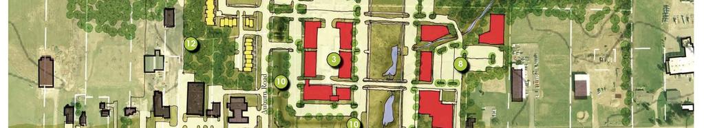
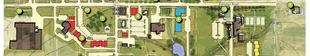
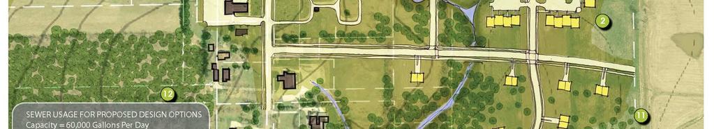
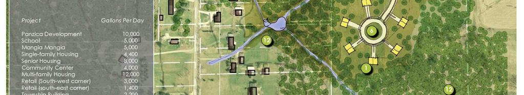
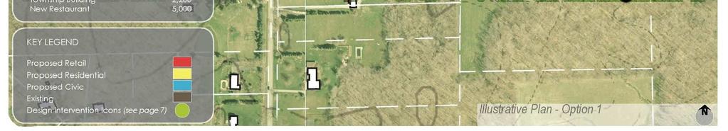
7 PHASE I OPTION 1 Design concepts shown in the long range vision will require a comprehensive sewer treatment system, which is not likely in the short term. A first phase of development is proposed for properties at the intersection of Auburn Road and Kinsman Road. This initial development is dependent upon the limited expansion of the existing sewer treatment plant located adjacent to the existing school complex. With upgrades, the existing plant is proposed to have a capacity of 60,000 gallons per day, accounting for the existing usage of Mangia Mangia and proposed uses planned for the Panzica development on the Northeast corner of the intersection (see Page A4-6). With this increased capacity, the Town Center Master Plan envisions a mix of uses including single and multifamily housing, retail development, connection of township facilities, community facilities and a new restaurant. Design Inventions See plans on Pages, A4-6, A4-8, & A4-9. Newbury Township Land Use Plan A4-7


8 PHASE I OPTION 2 On site stormwater management systems should be included in all new development and redevelopment projects. Rain gardens, bio-swales and bio-retention basins can be incorporated throughout development sites and included in parking fields without removing development capacity. The three options look at the different configurations for the Panzica development in the Northeast corner. Option 1 suggests a formal setting with a central green space connecting to the soccer and baseball fields of the Newbury High School. Newbury Township Land Use Plan A4-8


9 PHASE I OPTION 3 Options 2 and 3 look at more organic settings to separate the retail and office development, suggesting a stormwater drainage configuration that can connect the cemetery to the small lakes northeast of the Panzica site. These options vary within themselves in the way the retail uses and parking are designed on the site. Besides that, Option 3 also includes a relatively big-box store in the mix. Newbury Township Land Use Plan A4-9


10 Pedestrian Enhancements Easy access along and across Auburn and Kinsman Roads is an important element of the Master plan for Newbury. Pedestrian crossings are intended to be frequent, visible and effective as traffic calming devices. Special paving is needed to enhance the pedestrian environment. A crosswalk treatment should be installed at the main intersection. The plan envisions redeveloping the existing streetscape. The overall purpose is to create an integrated streetscape design that will enhance the aesthetics of the road, respect neighborhoods, provide opportunities for public art, and improve mobility for pedestrians and bicyclists. Newbury Township Land Use Plan A4-10


, a banner program and public art that thematically represent the themes prevalent in Newbury such as clean water, family, planning, green")
11 Comprehensive Streetscape Enhancements A comprehensive streetscape project will establish an identity and visual character for Newbury as a signature place in Geauga County. New sidewalks and streetscape elements are proposed: relatively formal in nature immediately at the Auburn/Kinsman intersection, but giving way to a more natural streetscape as you move away from the core. The theme of the streetscape is stone, water, and bio-retention. New street trees are proposed, but instead of a very linear streetscape with trees planted every 30 feet, the master plan suggests clumps of trees at strategic places. Gateway and streetscape elements should incorporate stone throughout. Decorative pedestrian lighting (perhaps solar), a banner program and public art that thematically represent the themes prevalent in Newbury such as clean water, family, planning, green building, and greenspace conservation would be an appropriate design strategy to bring together new and existing development and will work to enhance the identity of Newbury as a destination in the region. Newbury Township Land Use Plan A4-11


12 Achieving Appropriate Design As with many of our recommendations, the key is to establish development standards or policies that reflect both sound design principles as well as the desire of the public. Although townships cannot mandate design review, design guidelines can still assist developers before they begin to plan future projects and sharing the ideas generated in this design process is encouraged. Always ask for something better. The township will review and evaluate all new building projects and issue zoning permits. This review can be an opportunity where some design changes can be influenced, including landscaping, exterior building materials and architectural elements. Local residents, property owners and merchants all care about the visual outcome of development irrespective of any regulatory requirement for design review. The community and its leadership should provide ideas, based on this plan, to help achieve an appropriate balance between historic and aesthetic considerations and the economic realities every property owner and developer should address. Voluntary guidelines may not provide sufficient protection, but at times when the township is a participant in the development equation (site plan review, variances requested), the township should encourage developers to provide the best design outcome possible with the most appropriate and durable materials. Examples By The Urban Design Center of Northeast Ohio Paul A. Vernon, Architect/Urban Designer, Project Manager Terry Schwarz, Senior Planner Gauri Torgalkar, Urban Designer David Jurca, Urban Designer Newbury Township Land Use Plan A4-12
Planning Districts INTRODUCTION
 INTRODUCTION To facilitate detailed examination of development prospects for all areas of the community, Delano has been divided into 14 planning districts. The location of these planning districts is
9 th Street Sub Area Plan
 9 th Street Sub Area Plan In the 1990 s, when the Township prepared the last Master Plan, the 9 th Street corridor was studied as part of a larger 9 th Street Focus Area that included the West Main Street
Description of Preferred Alternative
 Chapter 2 Description of Preferred Alternative 2.1 Introduction This chapter of the programmatic Sammamish Town Center Sub-area Plan Final EIS provides a more detailed description of the Preferred Alternative
Potential Green Infrastructure Strategies May 6, 2015 Workshop
 Potential Green Infrastructure Strategies May 6, 2015 Workshop Background The City of Cortland is developing the Tioughnioga Urban Headwaters Green Infrastructure Action Plan with funding from the National
EXISTING COMPREHENSIVE PLAN
 EXISTING COMPREHENSIVE PLAN Town Center Land Use Element: V. LAND USE POLICIES Town Center Mercer Island's business district vision as described in "Your Mercer Island Citizen-Designed Downtown" was an
Small Area Plan. South Gateway
 Small Area Plan Adopted May 12, 2008 South Gateway Purpose. The South Gateway Small Area Plan defines the City s expectations for the future of the southern entrance to the City at Interstate 85 and Highway
Corridor Identity. Section 9. Introduction. Corridor Guiding Principles
 Corridor Identity An attractive and healthy community is a critical element of a quality place, and the design of quality places is a balance between environmental, economic, and social considerations.
section five BEAUTIFICATION PLAN
 section five BEAUTIFICATION PLAN BEAUTIFICATION PLAN Section Five Beautification Plan The goal of the Beautification Plan is to improve the Route 8-Sunnyland Corridor in terms of aesthetics and to create
Appendix E: Illustrative Green Infrastructure Examples
 Appendix E: Illustrative Green Infrastructure Examples Integrating LID into San Francisco s Urban Landscape Figure E. High-density Residential Figure E. Low-density Residential Figure E. Mixed Use 7 Figure
Olde Towne Vision Plan
 Olde Towne Vision Plan Introduction In 2016, the City of Bellevue will complete its move of City offices from Olde Towne Bellevue to its new municipal complex on Wall Street. The City intends to sell its
Route 347. New York State Department of Transportation Region 10, Long Island. THE GREENING of ROUTE 347
 The GREENING of Route 347 The Greening of Route 347 The Greening of Route 347: History 3 The Greening of Route 347 4 The Greening of Route 347 5 The Greening of Route 347 Smith Haven Mall 6 The Greening
Transportation. Strategies for Action
 Transportation A major priority for the Overlake Neighborhood is to develop a multimodal transportation system. To achieve this system, a balance has to be found among travel, circulation and access needs;
Hockessin Community Redevelopment Plan
 Hockessin Community Redevelopment Plan 3.1 Introduction The Community Redevelopment Plan for the Village of Hockessin is the result of the people s vision for a distinct village center that serves as the
SECTION II SECTION II STATEMENT OF GOALS, OBJECTIVES, PRINCIPLES, ASSUMPTIONS, POLICIES AND STANDARDS
 STATEMENT OF GOALS, OBJECTIVES, PRINCIPLES, ASSUMPTIONS, POLICIES AND STANDARDS 1 2 STATEMENT OF GOALS, OBJECTIVES, PRINCIPLES, ASSUMPTIONS, POLICIES AND STANDARDS INTRODUCTION The New Jersey Municipal
UNIVERSITY OF MICHIGAN:
 Chapter Eight UNIVERSITY OF MICHIGAN: North Campus I. Introduction The University of Michigan currently owns approximately 800 acres of land in the northeast section of Ann Arbor. North Campus refers to
Kirtland, Ohio - Comprehensive Plan Update 2022
 Kirtland, Ohio - 2022 Comprehensive Plan Update November 2012 INTRODUCTION City of Kirtland Officials... 1 Update: Preface... 2 City Charter Requirement: Purpose & Process... 3 THE PLAN Comprehensive Update:
Draft Memorandum #1: Goals and Vision for Revitalization
 Keizer Revitalization Plan Draft Memorandum #1: Goals and Vision for Revitalization Submitted to: City of Keizer April 12, 2018 (revised) Prepared By: Angelo Planning Group and Otak, Inc. Project No. 17482.A
Century Highfield Sub Area Plan
 Century Highfield Sub Area Plan The Century Highfield Sub Area Plan provides an opportunity to re evaluate the vision that was set forth for this area when the Township conducted a similar planning exercise
Public input has been an important part of the plan development process.
 Lakewood s Comprehensive Plan recognizes that transportation helps shape the community, and that the way the community provides for the safe and efficient movement of people affects the character of the
Germantown Forward Status Report to the Planning Board M NCPPC
 Germantown Forward Status Report to the Planning Board Germantown Forward March 27, 2008 What s new? CCT alignment Capital Improvement Program Agency partners Water quality conditions Sustainability Design
hermitage town center
 hermitage town center A Community Vision prepared by Strada for The City of Hermitage and The Mercer County Regional Planning Commission January 2007 table of contents introduction 3 design principles
Gold Line Bus Rapid Transit Transit Oriented Development (BRTOD) Helmo Station Area Plan
 Helmo Station Area Plan") Appendix F Gold Line Bus Rapid Transit Transit Oriented Development (BRTOD) Helmo Station Area Plan Introduction and Purpose of the Plan The Gold Line Bus Rapid Transit facility is an eleven-mile dedicated
Appendix F Gold Line Bus Rapid Transit Transit Oriented Development (BRTOD) Helmo Station Area Plan Introduction and Purpose of the Plan The Gold Line Bus Rapid Transit facility is an eleven-mile dedicated
M E M O R A N D U M SITE DATA
 Department of Community Planning & Economic Development 250 South 4 th Street, Room 300 Minneapolis, MN 55415-1385 M E M O R A N D U M TO: City Planning Commission, Committee of the Whole FROM: Lisa Steiner,
SECTION UNIFIED DEVELOPMENT ORDINANCE SECTION Part 1 Ordinance. ARTICLE 1 Zoning Districts
 SECTION 1-100 UNIFIED DEVELOPMENT ORDINANCE SECTION 1-300 Part 1 Ordinance SECTION 1-100. Introduction. ARTICLE 1 Zoning Districts Crystal Lake strives to maintain a balance of various land uses for a
Policies and Code Intent Sections Related to Town Center
 Policies and Code Intent Sections Related to Town Center The Town Center Vision is scattered throughout the Comprehensive Plan, development code and the 1994 Town Center Plan. What follows are sections
Comprehensive Plan Advisory Panel Meeting #3
 Comprehensive Plan Advisory Panel Meeting #3 November 7, 2016 Agenda 1. September 19 th Meeting Notes 2. Summary of Focus Areas Charrette 3. Heart of the City Focus Area a. HOC2/Station Areas Concept &
Beatties Ford Road & Mt. Holly-Huntersville Road Small Area Plan
 Beatties Ford Road & Mt. Holly-Huntersville Road Small Area Plan Town of Huntersville October 2005 Town of Huntersville Planning Department 101 Huntersville Concord Road Post Office Box 664 Huntersville,
CHAPTER 2: FUTURE LAND USE CONCEPTS
 CHAPTER 2: FUTURE LAND USE CONCEPTS INTRODUCTION The future land use concepts presented in this chapter are an expression of community support for a viable and vital US 50 Corridor. Land use recommendations
Table of Contents. Elm Avenue Improvement Plan City of Waco, Texas. Introduction 1. Existing Context 1 Figure 1 2.
 Table of Contents Introduction 1 Existing Context 1 Figure 1 2 Plan Guidelines 3 Future Urban Form 4 The West-End 4 Main Street 6 The East-End 7 Figure 2 9 Public Improvement Recommendations 7 General
Colerain Township report to. Hamilton County Regional Planning Commission. December 2, 2010, 1:00PM. t a f f r e p o r t
 Colerain Township report to Hamilton County Regional Planning Commission December 2, 2010, 1:00PM Preliminary Plan: Case No.: ZA2001-04, Forevergreen Prepared By: Amy Bancroft, Land Use Planner t a f f
PLANNED UNIT DEVELOPMENT & SUBDIVISION STAFF REPORT Date: May 18, 2017
 & PUD-0000102-2017 PLANNED UNIT DEVELOPMENT & SUBDIVISION STAFF REPORT Date: May 18, 2017 NAME SUBDIVISION NAME Dauphin Creek Estates Subdivision Dauphin Creek Estates Subdivision LOCATION CITY COUNCIL
BROOKHILL NEIGHBORHOOD MODEL ZONING MAP AMENDMENT PREFACE TO APPLICATION
 BROOKHILL NEIGHBORHOOD MODEL ZONING MAP AMENDMENT PREFACE TO APPLICATION June 15, 2015 Revised: August 1, 2016 I. VISION Brookhill is a proposed community based upon the principles of Albemarle County
Toronto Complete Streets Guidelines
 Toronto Complete Streets Guidelines 108 110 7.1 Green Infrastructure Design Principles 112 7.2 Context-Sensitive Green Streets 114 7.3 Key Green Street Elements Green infrastructure refers to natural and
P A I N E S V I L L E D O W N T O W N P L A N
 DEVELOPMENT YIELDS In addition to the qualitative aspects of the plan, it is important to understand the redevelopment concepts from a quantitative standpoint. How many new homes are being proposed p in
FLOOD ISSUE 62 INTRODUCTION
 V I S I O N 2 0 3 0 Southwest Missouri is known for its extreme range in weather that can cause flash flooding in a moment s notice. This flooding can unfortunately lead to extreme damage and serious injury,
MALLETTS BAY INITIATIVE
 MALLETTS BAY INITIATIVE Stormwater Management & Transportation Scoping Study January 19, 2017 Project Team Bryan Osborne Director of Public Works Sarah Hadd Director of Planning & Zoning Marshall Distel
NEIGHBORHOOD DESIGN ELEMENT
 NEIGHBORHOOD DESIGN ELEMENT INTRODUCTION The following recommendations constitute an urban design oriented "neighborhood analysis" of Plantation. It is an optional Comprehensive Plan Element. The five
City of Grande Prairie Development Services Department
 City of Grande Prairie Development Services Department ROYAL OAKS NORTH OUTLINE PLAN OP-07-03 NW 35-71-6 W6M May 7, 2007 Royal Oaks North Outline Plan TABLE OF CONTENTS 1.0 INTRODUCTION........ 3 1.1 Purpose
Pine Island Road Corridor Master Plan
 RECOMMENDED DEVELOPMENT PLAN Figure 9: Del Prado Village District Conceptual Framework The Conceptual Framework (Figure 8) for development of the Pine Island Corridor is to encourage mixed-use development
Study Area. Capitol Way. Greening America s Capitals 11/13/2014. A Greening America s Capitals Project
 Olympia, WA: Greening Capitol Way Supporting Communities move towards sustainability is a priority for the federal government. A Greening America s Capitals Project Office of Sustainable Communities U.S.
Community Open House March 26 th, 2018
 Community Open House March 26 th, 2018 Open House Agenda 1. Overview of Planning Process What we heard 2. Future Land Use Policy 3. Priority Growth Areas 4. Plan Elements Making it happen What is a Comprehensive
Port Lavaca Future Land Use
 Port Lavaca Future Land Use Introduction The City of Port Lavaca is beginning to see sustained growth, after many years of relative stable population. New single family homes, apartments, and businesses
CITY OF COLWICH COMPREHENSIVE PLAN LAND USE LAND USE 1
 LAND USE LAND USE 1 WHAT YOU WILL FIND IN THIS CHAPTER: Discussion of today s conditions and tomorrow s projections Discussion of challenges and opportunities Discussion of the environmental quality goals,
MEETING PURPOSE AND OVERVIEW
 MEETING PURPOSE AND OVERVIEW On February 23, 2012, the City of Elk Grove hosted the first of two community workshops related to the Southeast Policy Area. The workshop was held from 6:00 8:30 p.m. in the
The Private Role in a Public-Private Partnership. Ask Me Anything Conference May 30, 2018
 The Private Role in a Public-Private Partnership Ask Me Anything Conference May 30, 2018 1 Thoughts to Share Today Schmit+Associates Essential Elements of a P3 Community Vision Market Demand Economic Viability
Section4 Design Vision & Implementation Plan
 Section4 Design Vision & Implementation Plan W Woodschurch Rd 4.1 Design Focus Areas The Framework Plan is simply the starting point for directing the design and implementation of a wide range of transportation
Design Guidelines and Development Standards for Southwood Ranch. Prepared February, 2016 by
 Design Guidelines and Development Standards for Southwood Ranch D e s i g n D i s t r i c t Prepared February, 2016 by Table of Contents Introduction 2 District Overlay Map. 3 Development Standards. 4
EXECUTIVE SUMMARY DRAFT CHAPTER 1 INTRODUCTION EXECUTIVE SUMMARY
 CHAPTER 1 EXECUTIVE SUMMARY INTRODUCTION Through the joint efforts of the City of Tulsa planning staff and the Land Services division of Indian Nations Council of Governments (INCOG), the Berryhill Land
Mark-up of the effect of the proposed Bronte Village Growth Area OPA No.18 on the text of section 24, Bronte Village, of the Livable Oakville Plan
 Mark-up of the effect of the proposed Bronte Village Growth Area OPA No.18 on the text of section 24, Bronte Village, of the Livable Oakville Plan Notes: This document is provided for information purposes
Town Center. Block 5 Existing multifamily residential units are expected to remain.
 Area Guidelines Germantown s districts should be developed as distinct communities with unique features that are supported through the guidelines. The guidelines not only help distinguish these districts
Secrest Short Cut and Monroe Expressway Small Area Plan AUGUST 29, 2018
 Secrest Short Cut and Monroe Expressway Small Area Plan AUGUST 29, 2018 Background and Process Monroe Expressway will be open by the end of 2018 Union County and Indian Trail identified a need to revisit
North Fair Oaks Community Plan Summary and Information
 North Fair Oaks Community Plan Summary and Information WHAT IS THE NORTH FAIR OAKS COMMUNITY PLAN? The North Fair Oaks Community Plan is part of the San Mateo County General Plan, and establishes policies
DRAFT ROOSEVELT ROAD. District Recommendations. Figure 5.23 The Roosevelt Road Corridor
 CHAPTER 5 Figure 5.23 The Road Corridor Road will develop as a mixed-use corridor, emphasizing regional retail, west of the river and mixed-use development east of the river. KEY RECOMMENDATIONS 1. High
KANATA CENTRUM 255 KANATA AVENUE OFFICIAL PLAN AMENDMENT ZONING BY-LAW AMENDMENT
 KANATA CENTRUM 255 KANATA AVENUE OFFICIAL PLAN AMENDMENT ZONING BY-LAW AMENDMENT JUNE 2015 PREPARED BY: FOTENN Consultants Inc. 223 Mcleod Street Ottawa, ON K2P OZ8 (613) 730-5709 PREPARED FOR: Kanata
Corridors. Re-vitalize our Corridors and Gateways
 Corridors Re-vitalize our Corridors and Gateways Artist s rendering from the 287 Strategic Plan, 2015 Corridors are the major throughways of Loveland but they also provide important commercial, community
Proposed Comprehensive Plan Strategies DRAFT for discussion June 28, 2017
 Proposed Comprehensive Plan Strategies DRAFT for discussion June 28, 2017 Land Use Rural Areas Refine the Farm and Forest area (FF) Update FF boundaries to account for existing lots less than five acres
CHAPTER 7: Transportation, Mobility and Circulation
 AGLE AREA COMMUNITY Plan CHAPTER 7 CHAPTER 7: Transportation, Mobility and Circulation Transportation, Mobility and Circulation The purpose of the Transportation, Mobility and Circulation Chapter is to
4. INDUSTRIAL 53 CASTLE ROCK DESIGN
 4. INDUSTRIAL 53 CASTLE ROCK DESIGN CASTLE ROCK DESIGN 54 4. INDUSTRIAL Overview Well-designed and attractive industrial centers are the product of blending economic realities with both functional and
Preserving Our Past. Securing Our Future.
 Heritage Woods/Traffic Montrose West Intersection Springside Dr./S.R. 18Intersection Flight Memorial Dr./ S.R. 18Intersection Red Roof Inn High Density Development Ridgewood/ Cleve-Mass Intersection Ridgewood/
Lehigh Acres Land Development Regulations Community Planning Project
 Lehigh Acres Land Development Regulations Planning Effort Summary In July, 2010 Commissioner Frank Mann invited the Lehigh Acres community to start discussing how to achieve their recently adopted community
One County s Success in Linking Watershed Protection and Land Use Planning
 One County s Success in Linking Watershed Protection and Land Use Planning Bob Thompson Porter County Plan Commission March 28, 2012 Indiana Watershed Leadership Academy Population 160,000 Approximately
Bel-Air Lexus Automobile Service Station
 Bel-Air Lexus Automobile Service Station Design Brief 443-447 McArthur Avenue Ottawa April 30, 2015 14-1299-MCA Site Details Application: Site Plan Control Legal Description and Municipal Addresses: 443
Plano Tomorrow Vision and Policies
 Plano Tomorrow Vision and Policies PLANO TOMORROW PILLARS The Built Environment The Social Environment The Natural Environment The Economic Environment Land Use and Urban Design Transportation Housing
Approved: CITY OF ARDEN HILLS, MINNESOTA PLANNING COMMISSION WEDNESDAY, AUGUST 5, :30 P.M. - ARDEN HILLS CITY HALL
 Approved: CITY OF ARDEN HILLS, MINNESOTA PLANNING COMMISSION WEDNESDAY, AUGUST 5, 2015 6:30 P.M. - ARDEN HILLS CITY HALL PLANNING CASES A. Planning Case 15-016; Final Planned Unit Development Arden Plaza;
Lower Merion Commercial Districts Issues and Characteristics Handbook November 2013
 Lower Merion Commercial Districts Issues and Characteristics Handbook November 2013 DRAFT TOWNSHIP-WIDE VISION: To maintain and enhance commercial areas to complement the surrounding high-quality residential
OP Council Resolution June 16, Planning and Development Services
 OP-08-01 Council Resolution June 16, 2008 Planning and Development Services Kingsgate Landing Outline Plan Table of Contents 1.0 Introduction 1 1.1 Purpose of Plan 1 1.2 Plan Area Location 1 1.3 Ownership
urban design Introduction
 ACHIEVE SP RI NGF I ELD.3 Introduction Urban Design Areas Design Areas are areas within Springfield that have a unique and recognizable character that is different from other areas in the community. The
3 Vision and Goals. Vision and Goals. Blueprint for Bloomsburg. Vision. Town of Bloomsburg Comprehensive Plan,
 Vision and Goals 3 Vision and Goals Citizens of the Town of Bloomsburg clearly value their natural and cultural heritage, the walkable, mixed use pattern of downtown, the access to education, and the community
In the heart of the Southern Sector is a diamond in the rough
 WESTMORELAND DART STATION AREA PLAN Map III-2.24 The Westmoreland DART Station Area In the heart of the Southern Sector is a diamond in the rough the Westmoreland Transit Station. This DART station, near
Land Use. Hardware Street Vendor Mixed-Use
 Land Use Definition Land Use is the way a piece of real estate is utilized. Existing, proposed, and adopted land uses all play a role in the planning process. Once a land use plan is adopted, the next
4-Town Comprehensive Plan DRAFT 7/30/07
 4-Town Comprehensive Plan DRAFT 7/30/07 Acknowledgements ning Committee Town of Harrisburg Norman Roof Randy Nicol Town of Martinsburg Terry Thisse Paul Kelly Town of Montague Jan Bagdanowicz Wendy Perry
ARTICLE 6: Special and Planned Development Districts
 ARTICLE 6: Special and Planned Development Districts 6-10 Traditional Neighborhood Development (TND) District 6-10.10 Purpose and Intent The Traditional Neighborhood Development (TND) District provides
Gateway commercial MIXED USE MASTER SITE PLAN. CITILAND AIrDRIE GATEWAY VENTURE INC. airdrie GATEWAY COMMERCE CENTRE. airdrie, ALBERTA FEBRUARY 2012
 Gateway commercial MIXED USE MASTER SITE PLAN 1914 CENTRE STREET NORTH CALGARY, AB CANADA T2E 2S8 T. 403.264.7177 F. 403.264-7175 WWW.CITILAND.CA CITILAND AIrDRIE GATEWAY VENTURE INC. airdrie GATEWAY COMMERCE
CHAPTER VIII Implementation
 CHAPTER VIII Implementation VIII. Implementation The vision for the Marlboro Pike Corridor will require that a variety of participants work together to make it a reality. The following action steps outline
CHAPTER 20: NEIGHBORHOOD J
 CHAPTER 20: NEIGHBORHOOD J INTERSTATE 43 & RACINE QUARRIES Revisions approved by Council 11/15/16 via Ordinance #2579 PLANNING CONTEXT The Highway Interstate 43 & Racine Avenue interchange offers numerous
Zoning and Development Considerations in the Boothbay Harbor Maritime/Water Dependent District
 Zoning and Development Considerations in the Boothbay Harbor Maritime/Water Dependent District Bob Faunce Lincoln County Planner Lincoln County Regional Planning Commission Board of Selectmen and Planning
THE NEIGHBORHOOD TODAY
 THE NEIGHBORHOOD TODAY CORE AREA VISION How are we Good Urbanism A Site s DNA thinking about Elements of great Unique elements urban communities embedded in a place the site and design? ELEMENTS LIKE:
Preservation Planning
 Protect and Maintain the Historic Character of your Community Beverly, West Virginia Randolph County HLC PROTECT Purpose of all work done in survey and registration is not to only register properties.
NORTH COLLEGE PARK. Residential Neighborhood and Neighborhood Center OBJECTIVES EXISTING SITUATION AND ISSUES CONCEPT
 Greenbelt Metro Area Sector Plan - Subarea Design Policies and Guidelines - North College Park 119 NORTH COLLEGE PARK Residential Neighborhood and Neighborhood Center CONCEPT North College Park is envisioned
Town Center (part of the Comprehensive Plan)
") Town Center (part of the Comprehensive Plan) Mercer Island Town Center Looking North (2014) In 1994, a year-long process culminated in a set of design guidelines and code requirements for the Town Center
Town Center (part of the Comprehensive Plan) Mercer Island Town Center Looking North (2014) In 1994, a year-long process culminated in a set of design guidelines and code requirements for the Town Center
Municipal Plan*Assessment
 Municipal Plan*Assessment This tool was developed to assist in reviewing municipal master plans and in determining if these plans are consistent with smart growth principles, neighboring municipal plans,
EXISTING PLANS Harriet Festing Center for Neighborhood Technology Midlothian Community Meeting March 12, 2015
 EXISTING PLANS Harriet Festing Center for Neighborhood Technology Midlothian Community Meeting March 12, 2015 BENEFITS Bring economic, community + environmental benefits Enhance property values Use
CONCEPTUAL DEVELOPMENT PLAN REVIEW - CITY OF MARYLAND HEIGHTS
 APPLICATION NUMBER: CDP15-0004 APPLICATION (PROJECT) NAME: MARYLAND OAKS APPLICANT: PROPERTY OWNER NAME: APPLICANT S REQUEST: McBride Maryland Oaks, LLC 16091 Swingley Ridge Road, Suite 300 Chesterfield,
DRAFT Subject to Modifications
 TREASURE COAST REGIONAL PLANNING COUNCIL M E M O R A N D U M To: Council Members AGENDA ITEM 8 From: Date: Subject: Staff May 19, 2017 Council Meeting Florida Department of Transportation Complete Streets
COMPLETE GREEN STREET CHECKLIST
 COMPLETE GREEN STREET CHECKLIST This document was developed to dissect the structure of an urban street and explore opportunities to make our streets more complete while also integrating green street strategies.
TRANSPORTATION & STREET DESIGN
 TRANSPORTATION & STREET DESIGN Review of Goals Connect neighborhoods to Square Enable access to the river Improve pedestrian environment Reorient road network to local use Three Specific Areas of Intervention
TABLE OF CONTENTS 1.0 INTRODUCTION GENERAL OBJECTIVES LAND USE DESIGNATIONS, OBJECTIVES AND POLICIES 4
 Schedule I- Redstone Golf Course Resort Area Sector Plan 1 TABLE OF CONTENTS 1.0 INTRODUCTION 3 2.0 GENERAL OBJECTIVES 3 3.0 LAND USE DESIGNATIONS, OBJECTIVES AND POLICIES 4 4.0 TRANSPORTATION AND ROAD
TOWN BRANCH COMMONS & VINE STREET MOBILITY IMPROVEMENTS
 TOWN BRANCH COMMONS & VINE STREET MOBILITY IMPROVEMENTS CONTACT: Jeff Fugate, President O: 859-367-4972 F: 859-425-2292 JFugate@LexingtonDDA.com www.lexingtondda.com TOWN BRANCH COMMONS & VINE STREET MOBILITY
The open space system should provide connective elements, relate to natural resources, and enhance the suburban character of the landscape..
 The open space system should provide connective elements, relate to natural resources, and enhance the suburban character of the landscape.. Mixed-use and infill development should maintain or enhance
Drexel, Barrell & Co.
 Drexel, Barrell & Co. June 18, 2018 Engineers/Surveyors Boulder Colorado Springs Greeley 3 South 7 th Street Colorado Springs, Colorado 80905-1501 719 260-0887 719 260-8352 Fax El Paso County Planning
Street Flooding Mitigation Plan KYOVA Interstate Planning Commission. Presented to AMPO National Conference October 18, 2017
 Street Flooding Mitigation Plan KYOVA Interstate Planning Commission Presented to AMPO National Conference October 18, 2017 Saleem Salameh, Ph.D., P.E., M.ASCE Chet Parsons, AICP CTP Agenda: Background
Improve Neighborhood Design and Reduce Non Point Source Water Pollution
 HOW TO Planning Guide Improve Neighborhood Design and Reduce Non Point Source Water Pollution This document was funded by a grant from the New Hampshire Coastal Program with funding from the National Oceanic
Definitions. Average Daily Traffic Demand (ADT): The actual number or projected number of cars that pass a point in a 24-hour period.
: The actual number or projected number of cars that pass a point in a 24-hour period.") Definitions Access Management: A combination of physical techniques and transportation policies used to control the flow of traffic between roads and the surrounding lands. Alternative City Form Scenarios:
Definitions Access Management: A combination of physical techniques and transportation policies used to control the flow of traffic between roads and the surrounding lands. Alternative City Form Scenarios:
S o u t h C e n t r a l O u t l i n e P l a n. Leduc Business Park. North Leduc Industrial Area Structure Plan C it y of Led u c.
 Leduc Business Park North Leduc Industrial Area Structure Plan C it y of Led u c Prepared for Farm Air Properties Inc. January, 2007 Table of Contents Page Number 1.0 Purpose of Plan and Definition of
AMITY STATION Revised Concept Plan Review West Rosemary Street Chapel Hill, NC September 27, 2016
 AMITY STATION Revised Concept Plan Review West Rosemary Street Chapel Hill, NC September 27, 2016 DEVELOPER'S PROGRAM Introduction This is a request for review of a Revised Concept Plan by Chapel Hill
9IMPLEMENTATION AND PHASING
 9IMPLEMENTATION AND PHASING Purpose A key objective of the Railyard Master Plan is the integration of the public and private realm to provide a network of places that connect to and complement Commercial
The GATEWAYS Sub Area Master Plan. City of Walker
 The GATEWAYS Sub Area Master Plan City of Walker Introduction: The Walker City Commission and Planning Commission decided in 2011 to create a sub-area master plan for the Remembrance Road and Wilson Avenue
Strategic Growth Area #1 Northampton Boulevard Corridor Area
 Strategic Growth Area #1 Northampton Boulevard Corridor Area Description Strategic Growth Area #1 has established itself as a major employment center in Southside Hampton Roads. Opportunities exist to
Landscaping and Landscape Architecture
 A. General Overview This planning and landscape section has been prep ared to provide Property Owners, Architects, Contractors, and Builders/Developers with important information related to the development
SDOT DPD. SDOT Director s Rule DPD Director s Rule DCLU DR SED DR of 7 CITY OF SEATTLE
 SDOT SDOT Director s Rule 2-07 DPD Applicant: CITY OF SEATTLE Page 1 of 7 Supersedes: DCLU DR 11-93 SED DR 93-4 Seattle Department of Transportation (SDOT) Department of Planning and Development (DPD)