CHAPTER SEVEN CITY CENTER
|
|
|
- Aubrey Randall
- 5 years ago
- Views:
Transcription
1 CHAPTER SEVEN CITY CENTER 7.0 INTRODUCTION 1 Purposes POLICY BACKGROUND 2 Growth Management Act 2 VISION Countywide Planning Policies THE ROLE OF THE CITY CENTER IN FEDERAL WAY S FUTURE EXISTING CONDITIONS 5 City Center Planning Area 5 General Image 5 Land Use 6 Parks and Open Space 8 Civic Buildings and Municipal Facilities 8 Circulation 8 Residential 9 Infrastructure THE LAND USE AND TRANSPORTATION CONCEPT FOR THE CITY CENTER 10 The Concept Plan 10 Land Use Designations 11 City Center Core Area 12 City Center Frame Area 13 Circulation 13 Automobile Circulation 14 Pedestrian/Bicycle Connections 14 Transit 15 High Capacity Transit 16
2 Civic Buildings and Open Spaces 17 Parking 17 Streetscape THE URBAN CENTER VISION STATEMENT GOALS AND POLICIES IMPLEMENTATION 28 Implementation Strategies 29 Phasing Actions 30 Activity Since 1995 Comprehensive Plan Adoption 31 Maps Map VII-1, City Center Vicinity Map Map VII-2, City Center Boundary Map Map VII-3, City Center Land Use Designations Map VII-4, Current Land Use Map Map VII-5, Town Center Development Site Map VII-6, Boundaries of Planned Action SEPA Map VII-7, The Concept Plan Map VII-8, Proposed Street Network Map VII-9, Potential Location of Public Spaces and Pedestrian and Bicycle Connections Map VII-10, Potential Transit Alignment and Stops
. The City Center is comprised of both the City Center Core (CC-C) and the City Center Frame (CC-F).")
3 7.0 INTRODUCTION During a series of community workshops held in 1992 and 1993, Federal Way citizens helped to develop a vision for Federal Way s future. This vision included the creation of a City Center (Maps VII-1 and VII-2). The City Center is comprised of both the City Center Core (CC-C) and the City Center Frame (CC-F). With the support of the residential and business community, Federal Way nominated itself to contain an urban center/regional growth center. Nominations were reviewed by the Growth Management Planning Council (GMPC), which confirmed the Federal Way CC-C area as an urban center/regional growth center in This designation should help Federal Way continue to gain access to County funds needed to provide infrastructure as the City Center grows. The term urban enter is used in the Countywide Planning Policies (CWPPs) and the term regional growth center is used in VISION The term urban center will be used in this chapter to refer to the urban center/regional growth center. Urban centers are not specifically addressed by the Growth Management Act (GMA). Federal Way s City Center chapter presents concepts and strategies for creating a definable and vibrant City Center for Federal Way and an urban center for Southwest King County. The chapter integrates the community s vision for a City Center with the Puget Sound Regional Council s (PSRC) regional growth strategy, and King County s countywide strategy for developing a network of urban centers. Purposes The principal purposes of the Federal Way City Center chapter are to: Create an identifiable downtown that is the social and economic focus of the City; Strengthen the City as a whole by providing for long-term growth in employment and housing; Promote housing opportunities close to employment, shopping, and transit; VII-1
4 Support development of an extensive regional/high-capacity transit system; Reduce dependency on automobiles; Consume less land with urban development; Maximize the benefit of public investment in infrastructure and services; Reduce costs of and time required for permitting; Provide a central gathering place for the community; and Improve the quality of urban design for all developments. 7.1 POLICY BACKGROUND The City s comprehensive plan is required to be consistent with the GMA, Puget Sound Regional Council goals and policies of Vision 2040, and the CWPPs. The sections below briefly identify the relevant goals and policies related to city centers and urban centers contained within these documents. The City s specific goals and policies are consistent with these regional goals and policies and are contained within Section 7.7 of this chapter. Growth Management Act Per RCW36.70A.080, Comprehensive Plans, Optional Elements, comprehensive plans may include sub-area plans, which are required to be consistent with the overall comprehensive plan. Accordingly, there are no GMA goals that are specific to city centers or urban centers. However, the following goals pertain to compact growth such as envisioned for a city center and an urban center: VISION 2040 Urban Growth Encourage development in urban areas where adequate public facilities and services exist or can be provided in an efficient manner. Reduce Sprawl Reduce the inappropriate conversion of undeveloped land into sprawling, low-density development. VISION 2040 directs cities with urban centers to develop a subarea plan. Centers are intended to be central places with more compact, pedestrian-oriented development with a mix of residences, jobs, retail, and entertainment. Centers also provide community and economic benefits as gathering places and locations of commerce and business. VISION 2040 s multicounty planning policies call for the region to focus significant residential and employment growth within centers. Therefore, cities with regional growth centers must adopt housing and employment targets for their center. VISION 2040 also directs cities with designated centers to establish transportation modesplit goals for each center, in order to increase walking, biking and transit use. The build out of centers with a mix of uses and pedestrian-friendly design is expected to result in less driving and reduced pollution and greenhouse gas emissions. Centers are also prioritized for regional infrastructure and economic development funding. VII-2
5 VISION 2040 has a number of goals and policies related to centers. The following is the VISION 2040 goal and selected policies that are most relevant to Federal Way: Goal: The region will direct growth and development to a limited number of designated regional growth centers. MPP-DP-5: Focus a significant share of population and employment growth in designated regional growth centers. MPP-DP-7: Give funding priority both for transportation infrastructure and for economic development to support designated regional growth centers consistent with the regional vision. Regional funds are prioritized to regional growth centers. County-level and local funding are also appropriate to prioritize to regional growth centers. Countywide Planning Policies The Countywide Planning Policies (CWPPs) must be consistent with both the GMA and VISION Like VISION 2040, the CWPPs address only the urban center. A centers strategy is the key for King County to achieve VISION 2040 s regional growth strategy as well as providing a land use framework for an efficient and effective regional transit system. The CWPPs have a number of goals and policies related to urban centers. The following selected policies are most relevant to Federal Way: DP 29: Concentrate housing and employment growth within designated urban centers. DP 32: Adopt a map and housing and employment growth targets in city comprehensive plans for each urban center, and adopt policies to promote and maintain quality of life in the center through: A broad mix of land uses that foster both daytime and nighttime activities and opportunities for social interaction. A range of affordable and healthy housing choices. Historic preservation and adaptive reuse of historic places. Parks and public open spaces that are accessible and beneficial to all residents in the urban center. Strategies to increase tree canopy within the urban center and incorporate low impact development measures to minimize stormwater runoff. Facilities to meet human service needs. Superior urban design which reflects the local community vision for compact urban development. Pedestrian and bicycle mobility, transit use, and linkages between these modes. Planning for complete streets to provide safe and inviting access to multiple travel modes, especially bicycle and pedestrian travel. Parking management and other strategies that minimize trips made by single occupant vehicle, especially during peak commute periods. VII-3
6 7.2 THE ROLE OF THE CITY CENTER IN FEDERAL WAY S FUTURE There are several reasons why a definable, vital City Center is an important part of Federal Way s future. These include: Community Support The Federal Way community has made the City Center a significant part of its vision. Participants in community workshops helped to develop a vision for Federal Way s future. A keystone of that vision is an attractive, multi-faceted City Center providing the setting for commercial, residential, entertainment, recreational, and civic activities. Economic Development Federal Way s economic development strategy relies on a strong urban center. As discussed in the Chapter 4, Economic Development, Federal Way has the opportunity to transform itself from an essentially residential and retail based economy to an emerging, sub-regional economic center with an expanded, more diversified employment base. An important step in achieving this goal is a sufficient critical mass in the City Center to produce lively street activity; support specialty business and cultural/entertainment facilities; justify the investment for public parks, amenities, and improved transportation systems; and create the interactive synergy of a true urban center. Federal Way s economic development strategy with the development of Town Center I, II, III, and IV as described below, and shown in Figure VII-1 will greatly contribute to such a critical mass. The City has acquired 17 acres in the downtown and will be embarking on developing a Town Center, which includes four components: Four acres for a Performing Arts and Events Center (PAEC) (Town Center I). Four acres for a park (Town Center II). Eight acres for a hotel and potential development opportunities for office, medical office, higher educational facilities, retail and restaurants, along with arts and entertainment venues. In addition, there is a smaller component for office or institutional space (Town Center III). One acre for transit-oriented development (TOD) located west of the transit center and multi-story parking garage owned and operated by Sound Transit (Town Center IV). Natural Evolution The development of a more intensive, multi-use urban center is a natural step in Federal Way s evolution. Most new centers start out as bedroom communities. Growth Management Developing a City Center is part of a regional strategy to address Western Washington s growth management. Public policy makers have focused increased attention on issues affecting our quality of life, including urban sprawl and the accompanying reduction of open space, declining housing affordability, and increasing traffic congestion. Concentrating future growth within the four county region into a number of centers (rather than a continued pattern of dispersion), linked by an efficient high capacity transit system, is one of the principal goals to manage this growth. VII-4

7 Figure VII EXISTING CONDITIONS City Center Planning Area The City Center planning area, consisting of the CC-C and CC-F zones, is approximately 414 acres in size and is bounded by South 312 th Street, South 324 th Street, Interstate 5, 11 th Place South, and 13 th Avenue South (Map VII-3 ). The CC-C and CC-F areas are 209 and 205 acres, respectively. General Image The City Center does not currently present an identifiable sense of a downtown or urban center. The existing commercial development within the study area is typical of suburban strip retail and mall development. The dominance of mass retailing has largely shaped the commercial core. The Commons and spin-off retail centers are a local and regional destination and generate great amounts of physical and economic activity. However, as is the case with older suburban mall areas, there is little, if anything, distinctive or unique about the existing City Center. Essentially, it could be anyplace. It is similar to hundreds of VII-5
8 Land Use other commercial centers across the country. Buildings are dispersed throughout the area and lack pedestrian connections to each other, public rights-of-way, public and private spaces, residential neighborhoods, or civic uses, except by automobile. Development essentially reflects one pattern: a single story of light construction, surrounded by an apron of asphalt. Buildings feature concrete or concrete block walls, creating austere and generic images. Another prevalent image of the area is the vast amount of surface parking. The availability of parking is essential to the current type of retail found in Federal Way. City Center businesses serve regional as well as local markets, and are heavily oriented to access by automobile. Actual building footprints relative to total parcel areas are quite small; the majority of most parcels are used to provide surface parking. This parking is often underutilized, except during the peak holiday season. The current network of collectors and arterials, and the disjointed over-sized block grids within the existing commercial area, contribute to significant traffic congestion. The character of the street environment is also unfriendly to pedestrians in many locations, with few amenities such as benches, plazas, etc. In addition, in many locations the pedestrian experience is made even less attractive as little more than parking lots or blank walls line the sidewalks. Improvements throughout the City Center, most notably along South 320 th Street, Pacific Highway South/SR-99, 23 rd Avenue South, and South 312 th Street have improved the character of some streetscapes with handsome streetlights, street trees, and median plantings Continuation of these improvements elsewhere throughout the City Center will do much to improve the overall character of the City Center streetscapes. Similarly, the extensive abatement of unattractive, out-of-scale signage has also led to a more attractive, human-scale streetscape. The City Center does not contain a significant residential population. Pockets of residential housing exist between South 312 th and 316 th Streets, and between SR-99 and I-5. Figure VII-2 depicts an aerial view of the City Center area from the south looking north. Most of the study area is currently developed and consequently, most new development in this area will displace existing low intensity uses (Maps VII-4 and VII-5). The primary use in the City Center area is commercial (retail/service), followed by institutional uses, residential, office, and lodging. The Commons is the signature development in the area. Table VII-1 lists the amount of land use development by gross floor area within the City Center planning area as of April Institutional uses in the City Center are listed below. 320 th Street Park and Ride The Transit Center Town Center I (future Performing Arts and Event Center) Truman High School King County Library VII-6
 10,568,496 Institutional Uses 1,664,016 Vacant Land 616,189 Office 546,147 Hotel 466,380 5 657 Religious Services 193,070 Parks 174,825 Industrial 159,668 Utilities 37,886 Single")
9 Figure VII - 2 Aerial View of City Center Table VII-1 Gross Floor Area of Land Uses City Center, April 2015 Use Total Square Footage # Residential Units #Hotels #Hotel Rooms Commercial (Retail/Service) 10,568,496 Institutional Uses 1,664,016 Vacant Land 616,189 Office 546,147 Hotel 466, Religious Services 193,070 Parks 174,825 Industrial 159,668 Utilities 37,886 Single Family 1 Multi-family 502 Senior Housing 447 Open Space Recreation Total 14,426, Source: City of Federal Way GIS VII-7
10 Parks and Open Space There is one city-owned public park, Town Square Park (Maps VII-2 and VII-3), located within the City Center. Private green spaces, plazas and public meeting spaces are few. Steel Lake Park to the northeast and Celebration Park to the southwest are on the perimeter of the City Center. These parks are within walking distance of the City Center, and they also serve as regional facilities in addition to serving local needs. Civic Buildings and Municipal Facilities Similarly, the City Center lacks significant civic or municipal facilities, with only the Public Library near the periphery of the City Center. The next closest facility is the City of Federal Way Parks Department s Steel Lake Annex and Maintenance Facility near South 312 th Street and 28 th Avenue South. The Federal Way Community Center and City Hall are located a few miles southwest of the City Center at 876 South 333 rd Street and th Avenue South, respectively. Circulation Roadways A key element defining mobility within the City Center planning area is the enormous size of its blocks. Most U.S. downtowns have blocks ranging from 250 to 500 feet on a side; block lengths in Federal Way are several times that. Because of the superblock configuration, motorists drive between and within parking areas serving City Center developments to avoid congestion along City streets and pedestrian circulation is discouraged. Access to the area is provided by two principal arterial routes: South 320 th Street (which runs east/west and connects to I-5), and SR-99 (which runs north/south). An insufficient hierarchy of streets feed these arterial roadways. The area lacks a system of minor arterial and smaller collector streets that could diffuse traffic efficiently away from these two principal arterials. The poor spacing of traffic signals also adds to congestion. As such, the accessibility provided by the juncture of these routes, initially attractive to area residents, has been lost due to growth in traffic. Transit Service A regional park and ride lot, located southwest of I-5 and south of South 320 th Street and the Federal Way Transit Center, which opened in early 2006 on a sevenacre site located at the southwest corner of South 316 th Street and 23 rd Avenue South at the northeast edge of Federal Way s City Center, generate most of the area s transit ridership during peak periods of the day. King County/METRO, Sound Transit, and Pierce Transit serve both of these sites. The 317 th direct access ramp for Sound Transit s Federal Way Transit Center and the Sound Transit Federal Way Transit Center opened in early 2006 and has improved regional transit speed and reliability because transit is able to access the city center without having to use the congested I-5/320 th interchange. The 317 th direct access ramp also benefits carpools and vanpools. VII-8
 revealed a deficiency of pedestrian facilities citywide. The central core was highlighted as one of the areas that lacked an adequate pedestrian network.")
11 Pedestrian Environment and Bicycle Facilities A 1992 inventory of existing sidewalks within the City (see page V-22 of the Community Profile, Feb. 1993) revealed a deficiency of pedestrian facilities citywide. The central core was highlighted as one of the areas that lacked an adequate pedestrian network. For example, most of SR-99 and portions of 324 th Street and 23 rd Avenue South lacked sidewalks, although a series of street improvements has corrected this. The majority of walking that takes place in the city center occurs within malls and along storefronts of shopping center strips. Sidewalks connecting storefronts to public walkways are lacking. Crossing wide, busy streets such as South 320 th Street and SR-99 can also be intimidating. There are few places to sit and enjoy pleasant weather, meet friends, or have lunch outside. The current pedestrian environment is unfriendly and unappealing. The division that exists between pedestrians and auto areas is not conducive to establishing the active street life desired in a City Center. Bicyclists have even fewer facilities to choose from. City streets lack striping or signage for bike riders who must share the road with heavy volumes of traffic. Once bicyclists reach the area, they become frustrated by the lack of safe storage facilities for their vehicles. Covered bike parking is now provided at Sound Transit s Federal Way Transit Center. Residential The CC-F contains approximately 502 multi-family units of housing (listed in Table VII-1), located primarily in the area east of SR-99, south of South 312 th Street, north of South 316 th Street, and west of 28 th Avenue South. Other residential neighborhoods surround the City Center area, such as the pockets of multi-family housing west of 11 th Place South and south of South 320 th Street. There are also single-family neighborhoods west of Highway 99 and north of the South 312 th Street corridor. While these neighborhoods are not located immediately within the City Center, they are located conveniently within walking, bicycling, or vehicular distance. They differ greatly in character and type. Approximately 47 percent of all residential units in the City Center are senior housing. In 1997, two senior housing projects were constructed in the CC- F. These projects are located south of South 312 th Street and east of 23 rd Avenue South, adjacent to the southern portion of Steel Lake Park. The two projects, Meridian/Willamette Court and Woodmark at Steel Lake, consist of 300 and 85 living units respectively. In 2010, a 62-unit senior housing project adjoining the Transit Center was constructed in the CC-C. The residents of these developments have easy access to several shopping opportunities and services in the City Center area. VII-9
12 In an effort to stimulate additional multi-family development in the City Center, the City adopted a multi-family tax exemption in February In addition, the City adopted a Planned Action SEPA in September 2006 for a sub-area of the City Center, 200 acres in size, more specifically described as an area bounded on the north by South 312 th Street, on the south by South 324 th Street, on the west by Pacific Highway South, and on the east by 23 rd Avenue South. In April 2010, the City Center Planned Action Area was expanded to add approximately ten acres and five parcels. Its boundaries are South 317 th Street to the north, South 320 th Street to the south, 23 rd Avenue South to the west, and the eastern boundary is roughly in alignment with 25 th Avenue South (Map VII-6). The planned action designation applies to proposed residential, retail, office, hotel, civic, and structured parking development falling within the development envelope analyzed in the Environmental Impact Statement (EIS) for the planned action. The Planned Action SEPA and increased heights for mixed-use buildings containing multi-unit housing in the CC-C and CC-F are intended to encourage construction of multi-unit housing in the City Center area. Infrastructure Most of the existing facilities and infrastructure were inherited from King County. In 1998, the City adopted new streetscape guidelines related to roadway profiles, streetlights, sidewalk widths, and street trees. A list of infrastructure improvements made since incorporation can be found in Section 7.8 of this chapter. 7.4 THE LAND USE AND TRANSPORTATION CONCEPT FOR THE CITY CENTER The Concept Plan The concept is to redevelop the City Center and create a compact urban community and vibrant center of activity. The crux of the strategy is to promote a compact urban center with connections between where we live, work, and recreate, and to create an urban environment that is amenable to walking, bicycling, and transit. The concept, a result of the citizen participation process called CityShape (held in ), implements the community s goals outlined in Section 7.7. In summary, the concept is to: Establish an environment that supports high capacity transit (HCT) by locating residents and workers within convenient walking distance of HCT. Make efficient use of existing capital improvements by concentrating higher intensity land uses in the City Center. Encourage a mix of compatible uses where housing coexists, above commercial developments. Create a dense residential community within walking and bicycling distance of the City Center. VII-10
13 Improve auto circulation in the City Center by completing the proposed street grid, creating smaller blocks, and providing opportunities for through traffic to travel around rather than through the core, thus minimizing the impact of future growth on Citywide traffic patterns and congestion. Reduce impact of parking by encouraging structured parking; allowing reduced parking ratios, shared parking, and other innovative and creative parking solutions, as well as implementing guidelines that enhance appearance. Create pedestrian and bicycle connections throughout the City Center and to surrounding neighborhoods. Provide a safe and inviting environment for pedestrians and bicyclists with direct connections between activities and transit facilities. Continue to develop and/or reconstruct streets to include sidewalks, street trees, benches, garbage receptacles, screening of parking areas, etc. Create high amenity pedestrian-friendly corridors through the City Center, linked to a transit center and providing an attractive civic focus to the Commons. Provide a civic focus to create a sense of identity for all residents. Develop municipal and cultural facilities within the City Center area. Develop public spaces in the City Center, particularly the core area. Enhance the City Center with a network of public spaces and parks connected to the Citywide and regional system of open spaces, parks, and trails. Encourage gathering spaces in private development. Adopt strategies to protect views such as Mount Rainier, especially for civic uses and public parks. Map VII- 7 applies the principles described above. The CC-C area is located between SR- 99 and I-5 and between South 316 th /317 th and South 324 th Streets. The City Center core area contains a concentration of higher-density, commercial, residential, and mixed-use development, as well as civic, social and cultural uses. The CC-F area surrounds the core along the west and north edges and provides a full complement of similar uses to those in the core at somewhat lower densities. It also provides a transition to surrounding singlefamily neighborhoods. High capacity transit serves the City Center, and pedestrian pathways connect the HCT station with residential areas, existing and future civic spaces, and the Commons. Land Use Designations This section expands on the land use concepts described previously. The City Center chapter contains two different land use designations, each with its own distinctive characteristics, intended to guide the evolution of the City Center (Map VII-3). The CC-C and CC-F designations give form to the concepts summarized in section 7.5. These land use designations direct the location and extent of growth, and will reshape the nature of development, transforming the area into a compact, vibrant City Center. VII-11

14 City Center Core Area The CityShape vision called for concentrating growth in an area where sufficient infrastructure capacity exists, or where such capacity can be provided efficiently. The infrastructure within the City Center, specifically the core area, is designed to handle the highest levels of demand within Federal Way. By orienting new growth around this investment, the existing capacity can be utilized to its fullest extent. The core area designation also encourages the concentration of new development to help reduce development pressure in other areas of Federal Way. Residents choose to live in higher-density housing for a variety of reasons. First, higherdensity is frequently less expensive than single-family housing. Second, the convenience and proximity to work, needed services, and cultural activities is very desirable for many people. Finally, many people find that they do not need a large, single-family detached house. Given their lifestyle, they appreciate the low maintenance and security of higherdensity living. There is a mutually supportive relationship between higher-density residential uses and commercial activities. The presence of housing also activates City Center streets, day and night. The City Center core area will also be the central gathering place for the community a place where the whole community can congregate and celebrate. Accordingly, the core will include Town Square Park, with public amenities such as water features, covered shelters, and unique landscaping. The Performing Arts and Events Center (PAEC) (Town Center 1) will be constructed to the north of Town Square Park (Town Center 2) (Figure VII-1 and Map VII-5). Figure VII-2 Potential Core Area Development VII-12

15 City Center Frame Area Establishing a City Center frame area provides a zone for dense mixed-use development that surrounds and supports the core. It also provides a transition between high-activity areas in the core area and less dense neighborhoods outside of the frame. The frame area allows uses that are similar to those in the core area, but are of lower-density and intensity. Together, the core and frame areas are complementary. Encouraging multiunit housing mixed with business and commercial use will help Federal Way meet regional land use goals and its housing and employment targets. This is accomplished by encouraging the development of housing close to employment and transportation centers. To help transform the character of this land use designation, regulatory and/or financial incentives should be explored in exchange for amenities that contribute to a more pedestrian oriented environment (Figure VII-3). Figure VII-3 Potential Frame Area Development Circulation The City Center chapter aligns with VISION 2040 and the CWPPs related to circulation. Regional travel trends continue to show more cars on the road because the population and, therefore, number of drivers continue to increase. However, as fewer millennials drive, and the population ages, there will be less trips per person, and a decrease in the number of people driving alone. The emphasis of the FWCP is to promote a variety of travel options such as van and car pools, transit, walking, and bicycling. The City will focus both on transportation improvements as well as influencing individual travel choices by increasing the attractiveness of alternatives to the automobile. These improvements should include: a smaller street grid, bicycle routes, public sidewalks and pedestrian pathways, clear and identifiable transit routes, and eventually light rail facilities. VII-13

16 Encouraging growth in a compact, well defined City Center will help promote bicycling, walking, and transit use, as well as encouraging shorter automobile trips. The City Center will be connected to other regional urban centers and areas of the City by a multimodal transportation system, including a fast and convenient regional transit system. Automobile Circulation The current network of collector roads and arterials, the disjointed grid, and large block sizes contribute to significant traffic congestion within the City Center. The solution is not necessarily to construct wider roads. Streets become less efficient as the numbers of lanes increases. Building new streets versus widening existing streets is more cost effective, yields greater capacity, and will have less impact on the City Center. Automobiles are likely to continue as a dominant mode of transportation. A comprehensive network of collector arterials and other streets must be developed to distribute this traffic and create more driving choices. To the extent possible, the City should connect streets to form a tighter grid within the City Center, especially in the core, by negotiating new public rights-of-way and building new streets. This interconnectivity serves to shorten and disperse trips, and consequently reduce travel on existing congested arterials. Map VII-8 indicates the proposed street network changes. Pedestrian/Bicycle Connections Pedestrian and bicycle mobility is a vital part of the future City Center circulation system. Improvements for pedestrians and bicyclists should support increases in transit services and promote the development of the City Center. This chapter addresses the lack of pedestrian amenities and pathways by recommending changes to the development patterns and transforming the character of the streetscape. As the street system is redeveloped to better accommodate the needs of pedestrians and bicyclists, a network of facilities for people on foot and bikes will be established such as already exists for people in cars. Reducing the size of the street grid as proposed, and creating pedestrian paths through larger parcels is critical to establishing walking patterns that reduce dependency on the automobile. As individual sites are designed and developed to be more pedestrian friendly, and as the City provides improved pedestrian linkages, the pedestrian system will handle an increasing share of trips. As such, the City adopted special street design standards for the City Center in These include 12-foot sidewalks with street trees and pedestrian-scale street lighting. As streets are constructed, additional amenities such as benches, trash receptacles, and landscaped corner treatments may be added. Bike lanes will also be provided in a grid tighter than the rest of the City on through streets that avoid multiple turn-lane conflicts. VII-14
17 Transit In addition to adding public sidewalks and creating mid-block pathways, Map VII-9 depicts six principal pedestrian connections to improve pedestrian circulation. The first goal associated with improved pedestrian/bicycle connections is developing connections between the HCT station, adjoining bus transfer facilities, and other uses. The pedestrian and bicycle system is essential to other travel modes, particularly transit. Many transit trips begin and end as pedestrian trips on public rights-of-way. Therefore, all buildings within proximity to where trips begin and end should be required to facilitate pedestrian and bicycle movement. The second goal is to establish pedestrian and bicycle connections to the Commons, the City s largest generator of vehicular and pedestrian traffic. Linkages between the transit station and the Commons are important. Unfortunately, South 320 th Street is wide, congested, and presents a significant barrier to this connection. Providing an at-grade pedestrian and bicycle crossing could increase congestion and vehicular and pedestrian/ bicycle conflicts. To facilitate this connection, and encourage redevelopment of existing parking areas, this chapter proposes the continued consideration of a pedestrian bridge spanning South 320 th Street. The pedestrian over-pass would create a major connection between two areas in the City Center that have a high potential for new development and redevelopment. The third goal is to connect the City Center to nearby neighborhoods and parks. Residential neighborhoods of varying densities surround the City Center. Steel Lake and Celebration Parks are located to the northeast and southwest of the City Center, respectively. Both pedestrian and bicycle trails should extend to these residential neighborhoods and parks. Roads extending to these areas should emphasize the pedestrian connection by including additional pedestrian amenities. In order to provide good pedestrian connectivity across multi-lane arterials such as South 320 th Street and Pacific Highway South, crossings should be provided more closely than the existing ¼-mile spacing of traffic signals. Unsignalized pedestrian crossings would not be very safe, yet closer spacing of traffic signals make two-way signal coordination impossible to achieve, creating much more congestion and worsening safety and air quality. These conflicting needs must be resolved through the design process as these streets are reconstructed. One solution, although it would an expensive one, would be to construct a pedestrian overpass across 320 th Street. Efficient, convenient, and reliable transit is an important component of the City s vision of reducing auto dependency through the creation of viable travel options. Transit will play an important role in the development of the City Center and the region as a whole. A multimodal system that includes transit will bring commuters and shoppers to and from other areas of Federal Way and adjacent communities. A high capacity transit system with a principal stop in the core area will distribute people regionally and connect to other bus based transit systems. Transit stops throughout the center will help shoppers, employees, and residents to circulate around the City Center without the need to get into their cars. Encouraging a mix of land uses and densities at major transit access points will help meet passenger needs and reduce vehicle trips. VII-15

18 High Capacity Transit The Federal Way Transit Center opened in early 2006, on a seven-acre site located at the southwest corner of South 316 th Street and 23 rd Avenue South, at the northeast edge of Federal Way s City Center. The transit center is a regional bus transit facility supporting Sound Transit, King County METRO, and Pierce Transit. It includes a five-level structured parking garage with 1,200 parking spaces, a pedestrian bridge between the transit decks and parking garage, bicycle storage, and shelters for waiting passengers. The Transit Center is considered by the City as a major anchor to the urban center designation in the Vision 2040 plan adopted by PSRC. The project also includes a high occupancy vehicle (HOV) direct-access ramp connecting the transit center to Interstate-5 via South 317 th Street. In addition, approximately one acre of the transit center site has been set aside for future transit-oriented development (TOD), and is now designated Town Center IV (Figure VII-I and Map VII-5), consistent with the comprehensive plan vision for the City Center. In 2010, Senior City, a TOD development of 62 units of senior housing, was constructed adjoining and east of the station. Sound Transit is working with Puget Sound citizens and City representatives to develop a HCT network linking Everett, Tacoma, Seattle, Bellevue, and communities between them. Three light rail stations are proposed in Federal Way, including one in the City Center. In April 2015, Sound Transit released an Environmental Impact Statement (EIS) regarding alignment and station location alternatives in the City Center. The EIS identifies two primary alignment alternatives: I-5 or Pacific Highway South. The EIS also identifies five potential station locations in the City Center. Two of the potential stations would facilitate a Pacific Highway alignment, and three would facilitate an I-5 alignment. Map VII-10 shows four stations, although the station just south of the existing Transit Station would facilitate both alignments. The Sound Transit Board will select a preferred alignment in VII-16
19 Civic Buildings and Open Spaces Parking Public buildings including community centers, libraries, city hall, performing arts and event centers, and schools provide places for the community to meet, exchange ideas, and socialize. The City should take advantage of every opportunity to locate a variety of civic buildings in and around the City Center. This will occur over time, but it is necessary to establish a clear direction through public policy. A network of outdoor spaces for recreation, strolling, gathering, and dining will make the City Center a lively and attractive place to live, shop, and conduct business. Each type of space should serve a range of users and activities. Outdoor spaces should range from a major urban park, like Town Square Park, that is the focal point for downtown, to pocket urban plazas for lunch time gathering by residents, visitors, and workers. Some spaces will be publicly built and maintained, others will be constructed along with private development. Privately developed gathering space is a major component of all City Centers: small parks and plazas are opportunities to enhance the urbanscape and image of the City Center. Courtyards and forecourts are ways to integrate open space to enhance a project. Visitors, shoppers, and employees often perceive these private spaces as public. The City should commit to assist in or provide incentives for, the development of plazas and parks that are open to the public Presently, Town Square Park (Town Center II) acts as a central outdoor gathering place within the core area, and it will become the focus of community activities in the core. The City is also in the planning process for Town Square 1, a Performing Arts and Events Center; Town Center III, an eight acre site now under the City s control, which will be redeveloped with a mix of commercial, residential, and educational uses; and Town Center IV, a one-acre transit-oriented development opportunity directly adjacent to the Transit Center (Figure VII-1). The continued use of expansive surface parking acts as an obstacle to redeveloping the City Center as a higher-density, mixed-use area that is pedestrian-friendly and supports the use of public transportation. It is, therefore, necessary to make more efficient use of parking and encourage the provision of structured parking within these areas. Moreover, parking lots have high redevelopment potential. There are numerous examples of communities similar to Federal Way where former parking lots now contain multi-story developments. Large amounts of parking will be needed for many years to come, however, as development pressures and land values increase, property owners may be able to afford the conversion from surface parking to structured parking. In the interim, the City should encourage site layouts that facilitate future redevelopment of parking areas. The City should examine the feasibility of partnering with the private sector to construct a parking structure in the downtown commercial core area. Figure VII-4 is a conceptual illustration of the redevelopment of surface parking around a mall. Additionally, the City may designate certain streets for on-street parking. VII-17
20 Figure VII-4 Potential Redevelopment of Surface Parking Areas Streetscape To improve livability within the City Center area, the City must complete the street network and continue to develop streets in accordance with its new street standards. The street grid must be well interconnected to make travel from one place to another as efficient as possible. The key to achieving this is to consider streets as a network that will serve pedestrians, bicycles, and transit, in addition to automobiles. In areas where increased density is proposed, existing streets must continue to be retrofitted with sidewalks, street trees, street furniture, and other amenities. Allowing on-street parking also creates a buffer between pedestrians and vehicles. It also allows shoppers and visitors to park easily for short amounts of time. On-street parking should be permitted on City Center streets, where feasible. The Transportation chapter illustrates several street standards developed specifically for the City Center area. These streets will connect to other proposed and existing streets to complete a street grid. These standards also incorporate the City Center Street Design Guidelines adopted by the City Council in May VII-18
21 7.5 THE URBAN CENTER Federal Way s CC-C area has been designated as an urban center. VISION 2040 has specific requirements about what must be included in urban center plans. These include land use; housing and employment targets; mode-split goals, key job sectors and industry clusters; and policies and programs for innovative stormwater management. Land Use The urban center is presently characterized by mostly retail and service, with only 62 units of senior housing constructed in 2010 (Table VII-II, Maps VII-4 and VII-5). A key element of VISION 2040 and the CWPPs is to focus growth into dense walkable mixed use urban centers. Housing Targets Demographic shifts in the housing market will contribute to the development of the urban center. These include a shrinking proportion of households with children and an increasing proportion of racially and ethnically diverse households and households with singles, families without children, and seniors. These growing demographic groups have historically shown a preference for higher-density housing near transit. To address, this demographic shift, the housing target for the urban center has been set at 2,521 units. This means that there is an additional target of 2,459 residential units, which is 30 percent of the overall city target of 8,100 residential units. Employment Major Employment Sectors As discussed in Chapter 4, Economic Development, and shown in Table VII-III, almost 23 percent of jobs in the City are in services, followed by health care, retail, and tourism. Based on data provided by PSRC, almost 59 percent of total jobs in the urban center are in the services sector (this excludes jobs in health care and tourism), with almost 32 percent in retail. PSRC suppresses employment information for a particular sector if there are very few employers in that sector in order to protect the identity of the employer. Therefore, even though the total number of jobs in the urban center in 2013 added up to 3,389, due to suppression of jobs neither the jobs nor percentages in the identified sectors will add up to 100 percent. Table VII-II Land Use in the Urban Center, April 2015 Use Total Square Footage Commercial (Retail & Service) 5,720,595 Institutional Uses 728,251 # Residential Units #Hotels #Hotel Rooms Hotel 385, Vacant Land 366,757 Religious Services 193,070 Parks 174,825 VII-19
22 Use Total Square Footage Office 123,069 Utilities 37,886 # Residential Units Senior Housing 30, #Hotels #Hotel Rooms Total Employment Category Services (Excluding Health Care & Tourism) Table VII-III 2013 Employment in the Urban Center Employees City-Wide Percentage of Total Employees Employees Urban Center Percentage of Total Employees 6, % 1, % Healthcare 5, % Retail 4, % 1, % Tourism 3, % Education 2, % Finance, Insurance and Real Estate Government: Public sector employment excluding education 1, % % 1, % Wholesale Trade, Transportation and Utilities Construction and Resources 1, % % Manufacturing % Total 29, % 3, % Source: PSRC 2013 Covered Employment Database Industry Clusters Industry clusters are geographically concentrated cooperative networks of interdependent firms and related institutions, where the close contacts of the members and the continuous, fast knowledge exchange between them contribute to the competitive increase of both the members and the whole region. An active local cluster includes firms and support organizations working together to achieve results that would not be possible individually. Cluster data for the Urban Center generated by PSRC can be found in Table VII-IV. VII-20
23 Table VII-IV Industry Clusters in the Urban Center Cluster Business Services Tourism ,212 1,161 Employment Targets VISION 2040 and the CWPPs envision urban centers to contain current or planned concentrations of the region s most significant business, governmental, and cultural activities with large regional markets. Accordingly, the total number of jobs for the year 2035 for the urban center has been set at 6,823. This means that there is an additional target of 3,434 jobs, which is 28 percent of the overall city target of 12,300 jobs. Transportation Concentrating growth in a specific area also supports investment in transit, including a regional HCT system. Existing low-density development does not generate sufficient levels of demand to optimize the return on investment in transit. Promoting higherdensity uses within walking distance of transit facilities will improve the viability of this significant infrastructure investment. Additionally, concentrating the highest density of development in the urban center, where a significant number of jobs and residences will be within walking distance of a transit station, helps reduce dependency on the automobile and improve pedestrian mobility. The urban center emphasizes pedestrian, bicycle, and transit mobility. As shown in Table VII-V, based on PSRC s 2010 Summary Statistics in the Federal Way Profile on Urban Centers, mode split in 2010 was 79 percent single occupancy vehicle (SOV). The City s 2040 goal for the urban center is a 70 percent SOV rate. Environment Table VII-V Mode-Split Goals Single Occupancy Vehicle 79% 70% High Occupancy Vehicle 9% 13% Walk and Bike 3% 4% Transit 9% 13% Source: PSRC s Federal Way Profile on Urban Centers and City of Federal Way Traffic Division Critical Areas There are no wetlands, streams, or geologically hazardous areas within the urban center. However, there are three aquifers that underlie the City. Federal Way is partially dependent on groundwater as a source of drinking water. Groundwater pumped from Lakehaven Utility District wells originates from these three aquifers. The Lakehaven wells are protected by regulations that designate wellhead protection zones. The western portion of the urban center is located within a 10-year wellhead protection zone. VII-21
24 Stormwater Management Conventional tools to manage stormwater runoff focus on mitigation and flood control by collecting runoff via conveyance systems and detaining the excess volume in ponds or vaults. However, the conventional tools typically do not provide local groundwater recharge, as they require large volumes of surface or subsurface storage, and provide limited water quality treatment. Consistent with Department of Ecology permit requirements, the City is moving toward making a low impact development (LID) approach as the preferred method, where feasible, to supplement or replace the conventional tools for stormwater management. LID shifts the stormwater focus from a structural measure to a source reduction approach. 7.6 VISION STATEMENT By the end of the comprehensive planning horizon in 2035, the Federal Way City Center has evolved into the cultural, social, and economic center of the City and fulfilled its role as one of Puget Sound s regional network of urban centers. This role is reinforced by pedestrian-oriented streetscapes; an efficient multi-modal transportation system; livable and affordable housing; increased retail, service, civic, and office development in a compact area; a network of public spaces and parks; superior urban design; and a safe and vibrant street life. The City Center is responsive to the needs of the City s residents. In addition to general services that draw people from outside the region, such as retail, office, cultural, entertainment, and hotel uses, the City Center is the primary commercial area providing local goods and services to the surrounding neighborhoods, and to residents and employees within the center area. Private development and City-initiated actions have resulted in a balanced transportation network that accommodates automobiles, public transportation, high occupancy vehicles, pedestrians, bicyclists, and integrated parking. Pedestrian, bicycle, and transit circulation is emphasized along with other travel modes. The downtown urban fabric includes smaller blocks, lending itself to efficient and pleasant travel. Concentrated development allows a significant number of jobs and residences to be located within close proximity to transit, including a High Capacity Transit Station (HCT), thus, reducing dependency on the automobile and improving pedestrian mobility. The regional HCT system with regional express bus service has evolved to include fixed guide-way systems, such as light rail. Direct access to a regional transit system links the City Center to Seattle, Everett, Tacoma, Bellevue, SeaTac International Airport, and other regional and local destinations. The diversity of housing opportunities now include high-rise and/or mid-rise mixed-use, which helps to meet a significant portion of the community s housing needs. City Center residents walk or take transit to shop, work, and recreate. Community facilities and services, public spaces, parks, and trails complement the variety of housing and provide places for residents to come together as a community. A central gathering place for the community, the City Center, is where the whole community can congregate and celebrate. Civic and cultural facilities including a VII-22
25 Performing Arts and Events Center, park and open-space system, meet the needs of residents, employees, and visitors. These amenities connect to the Citywide and regional system of open spaces, parks, and trails. Public and private projects contain such design elements as fountains, sculptures, and unique landscaping. The quality of urban design for all developments, including streets, buildings, and landscaping, is high and contributes to an improved quality of life. Public buildings and spaces also set a high standard for design and compatibility with adjoining uses. 7.7 GOALS AND POLICIES The following goals provide overall direction to policy makers and community members when making choices about growth and development within Federal Way s City Center. General Goals CCG1 Create an identifiable City Center that serves as the social, cultural, and economic focus of the City. Define a City Center with distinct boundaries, unique building types, and special features. CCG2 Attract a regional market for high quality office and retail uses which increases employment opportunities, adds to the City s tax base, and establishes Federal Way s City Center as an economic leader in the South King County region. CCG3 Foster distinct districts within the City Center, defining the roles and characteristics of each such district. CCG4 Encourage a mix of compatible uses to maintain a lively, attractive, and safe place to live, work, and visit. CCG5 Focus on improving the existing character and image of the City Center. CCG6 Encourage housing opportunities in commercial/residential mixed-use settings. Promote housing opportunities close to employment. CCG7 Encourage the availability of affordable housing to all economic segments of the population of this state, promote a variety of residential densities and housing types, and encourage preservation of existing housing stock. CCG8 Develop land use patterns that will encourage less dependency on the single occupant automobile. CCG9 Provide a balanced transportation network that accommodates public transportation, high occupancy vehicles, pedestrians, bicyclists, automobiles, and integrated parking. CCG10 Create an environment that attracts high quality housing, commercial, and office uses. Continue to enforce requirements for quality design in buildings, streetscape, and site planning. VII-23
26 Goal CCG11 Create policies and regulations to encourage more efficient use of parking facilities and to foster new, innovative, and creative parking solutions. CCG12 Focus new growth in the City Center and allow for higher intensity uses and densities. Policies CCP1 CCP2 CCP3 CCP4 CCP5 CCP6 CCP7 CCP8 CCP9 Support a concentration of uses within the City Center to create a financial, retail, business, civic, and cultural hub of Federal Way. Develop an attractive City Center that will attract quality development. Continue to support land use regulations that allow the higher intensity development expected over the next 15 to 30 years. Continue to develop a City Center that is the primary commercial area providing local goods and services to the surrounding neighborhoods and region, and to residents and employees within the center. Utilize the SEPA Planned Action to provide streamlined permit review in the City Center in order to accelerate progress towards meeting the vision. Work with urban service providers to ensure sufficient capacity is available for development. Allow for a variety of uses and mixed-use development within buildings, or complexes. Ensure that mixed-use development complements and enhances the character of the surrounding residential and commercial areas. Provide incentives to encourage residential development in City Center. Promote the siting of cultural and civic uses within the City Center. The City should always consider City Center sites in siting analyses and decisions regarding potential civic and cultural uses that it develops. In addition, incentives should be explored that could attract cultural and civic uses over which the City does not have direct control. CCP10 Continue to develop land use regulations that encourage the City Center to accommodate higher-density residential uses accompanied by residentially oriented retail and service uses. CCP11 Continue to provide amenities such as community services, parks, and public spaces to meet residential needs. CCP12 Continue to ensure effective transitions between frame area development and nearby lower-intensity development. VII-24
27 Goal CCG13 Improve the flow of vehicular traffic through the City Center and minimize increases in congestion. Policies Goal CCP13 Improve traffic flow around and through the City Center by extending the street network, creating smaller blocks, and completing the ring road along the west edge of the City Center. CCP14 Reduce congestion by supporting the Commute Trip Reduction Act. Develop commuting alternatives to single occupancy vehicles, including transit, walking, and bicycling. CCG14 Promote and facilitate the effective use of non-motorized transportation. Create a safe, efficient, and enjoyable pedestrian and bicycle system. Policies CCP15 Emphasize pedestrian and bicycle circulation, as well as other travel modes in all aspects of developing the City Center transportation system. Include public sidewalks, street trees, and other pedestrian amenities for streets. CCP16 Continue to enforce and refine zoning codes, site planning requirements, and street design standards, as necessary, to establish a more pedestrian and bicycle friendly environment. CCP17 Encourage new development to include active ground floor uses such as shops, community services, office, and restaurants. CCP18 Provide pedestrian connections between adjacent buildings where possible to provide for streetscape continuity and develop clear and safe pedestrian paths through large parcels to enhance the pedestrian network. CCP19 Continue to site and screen parking lots to minimize impact on the pedestrian environment. CCP20 Connect the main entry of buildings to public sidewalks by a clear, identifiable walkway. CCP21 Encourage transit use by improving pedestrian and bicycle linkages to the existing and future transit system, and by improving the security and utility of park-and-ride lots and bus stops. CCP22 Establish clear and well-marked pedestrian crossings to reach transit facilities and other uses at a maximum spacing of 660 feet. VII-25
28 Goal CCP23 Connect Celebration Park and Steel Lake Park via a pedestrian/bicycle pathway bisecting the City Center. Orient buildings, urban open spaces, plazas, etc., to pathways where feasible. CCP24 Continue to improve the pedestrian/bicycle circulation along South 320 th Street and Pacific Highway South. CCG15 Work with transit providers to develop a detailed HCT plan for the City Center. Identify facilities, services, and implementation measures needed to make transit a viable and attractive travel mode. Tailor the plan to meet local needs through rapid transit, express buses, and/or demand-responsive service. Policies Goal CCP25 Continue to focus transportation investments to support transit and pedestrian/ bicycle-oriented land use patterns. CCP26 Participate actively in regional efforts to develop an HCT system to serve the City Center. CCP27 Establish the most intensive levels of transit service to the City Center area. CCP28 Integrate any transit system with existing or new road rights-of-way. CCP29 Integrate the high capacity transit system with other transportation modes serving Federal Way and the region. CCP30 Integrate bicycle and pedestrian facilities with, and connect to, high capacity transit facilities during right-of-way acquisition and facility design. CCG16 Develop civic and cultural facilities in addition to a public space and park system within the City Center to meet the needs of residents, employees, and visitors. These facilities and spaces should connect to the Citywide and regional system of public spaces, parks, and trails. Policies CCP31 Promote a diversity of public and privately funded recreational and cultural facilities throughout the City Center. Promote partnerships between the City and other agencies, private organizations, and individuals to develop and meet the needs of the community for these types of facilities. CCP32 Acquire land necessary to provide a broad range of development opportunities throughout the City Center. VII-26
29 Goal CCG17 Encourage the development of a higher-density, mixed-use City Center that in turn will reduce parking demand per square foot or per unit. Policies Goal CCP33 Encourage public and private parking structures (below or above ground) in lieu of surface parking. As redevelopment occurs and surface parking becomes increasingly constrained, consider a public/private partnership to develop structured parking in the downtown commercial area. CCP34 Encourage the provision of structured parking. CCP35 Buffer parking areas to increase compatibility between surrounding uses. For larger lots, provide substantial landscaping, special lighting, and pedestrian walkways. CCP36 Site and orient buildings and parking to allow redevelopment of surface parking. CCP37 Allow on-street parking to create a buffer between pedestrians and traffic, depending on street characteristics and role within the City Center. On-street parking should be viewed as a component of the parking supply for the area. CCP38 Encourage shared parking between uses to maximize the use of available parking within the City Center. CCG18 Plan for land use patterns and transportation systems that minimize air pollution and greenhouse gas emissions. Policies Goal CCP39 Continue to build a multimodal transportation system, as described in Chapter 3, Transportation, so that people who live and work in Federal Way have a variety of convenient low-or no-emission transportation options. CCP40 Continue to promote commute trip reduction strategies as a way to reduce air pollution and greenhouse gas emissions. CCG19 As part of new development or redevelopment, encourage the use of innovative techniques such as Low Impact Development. Policies CCP41 Encourage the use of low impact development stormwater facilities, or use other similar stormwater management techniques to promote aquifer recharge. VII-27
30 Goal Policy Goal CCP42 Establish land use and building controls to use stormwater infiltration, such as low impact development and green stormwater infrastructure techniques wherever feasible, and to minimize the amount of impervious surface created by development. CCG20 Consider protecting views from civic buildings and uses, such as the Performing Arts and Events Center, for the enjoyment of citizens. CCP43 Consider providing incentives, and/or adopt regulations, for view protection of scenic vistas. CCG21 Maintain street designations that reinforce the unique characteristics of the City Center. Policies CCP44 Continue to acquire right-of-way, primarily through dedication from development, to complete and enhance the street network. CCP45 Continue to design streets as public spaces, with appropriate pedestrian amenities, trees, sidewalks, bicycle paths, transit services, street furniture, and trash receptacles. CCP46 CCP47 CCP48 CPP49 Continue to construct streetscape improvements as an integral component of any roadway improvement. Encourage buildings to front or face public rights-of-way, providing clear paths from the sidewalk to all entries. Do not widen any streets except for SR-99 and South 320 th Street to more than five lanes. Continue to look for opportunities such as the dedication of the flagpoles and the renaming of the downtown stretch of South 320 th Street as Memorial Way to reflect local values and create a unique community character. 7.8 IMPLEMENTATION Developing a City Center will require collaboration between government entities, citizens, and developers. Phasing and development of certain elements, such as high capacity transit, are outside the City s control. Therefore, an implementation program VII-28
31 must be flexible. It must also be tied to general goals, policies, and strategies rather than a detailed, step-by-step list of actions. The implementation section consists of: A set of strategies to guide implementing actions; An illustration of how these strategies can be realized over time; and An action plan. Implementation Strategies Specific strategies must be pursued in order to coordinate various elements and actions that are dependent upon one another. For example, private development depends upon adequate infrastructure and amenities. Effective transit service depends upon supporting land use development to provide sufficient ridership. Residential communities require adequate transportation and services, a pedestrian friendly environment, open spaces, and jobs to foster a sense of community. However, regulatory and infrastructure actions must be taken in the interim to prepare for these developments. The following strategies form the basis to achieve desired City Center development. Maintain regulations to shape and influence new development (1-20 years). Discourage low intensity auto oriented development in the City Center. Provide regulations and incentives to achieve a high intensity, mixeduse, pedestrian friendly development. Encourage high-density residential development in the City Center. Continue to provide incentives to foster desired redevelopment in the City Center. Maintain, and consider increasing the City Center redevelopment fund. Consider appropriate public-private partnership opportunities as they present themselves to leverage desired development. Pursue appropriate redevelopment of City owned parcels. Continue to respond to opportunities for City acquisition and repositioning of key properties as they become available. Develop specific plans to construct needed street and infrastructure improvements (1-5 years). Develop plans to define the location of street rights-of-way for completing the street grid and constructing transit facilities to provide predictability for developers. Construct arterial improvements with associated landscaping and pedestrian amenities (timing set by capital facilities program). Per the adopted pedestrian and bicycle plan, construct sidewalks, pedestrian paths, mid-block connectors, and bicycle connections to all areas of the City Center and particularly to the transit center (ongoing effort). VII-29
32 Consider development of structured parking facilities as needed to support more intensive development and gradually convert the City Center into a less auto dependent area. Improve both local and regional transit service. Coordinate with Sound Transit to develop a regional HCT station in the City Center (15-20 years). Construct civic features, public spaces, parks, and other urban elements to create a true urban center and promote civic identity (1-10 years). Develop major civic facilities in the City Center such as, Municipal Facilities, Performing Arts and Events Center, and parks, to generate social and economic activity. Include landscaping and pedestrian improvements in all street construction (incremental program tied to actual improvements). Phasing Transforming the existing downtown commercial area into the proposed City Center is an ambitious task. It requires a significant transformation from a low-density, automobile oriented, largely retail area to a higher intensity, more pedestrian oriented mixed-use area. This chapter acknowledges that the City Center will take some time to develop. The City can facilitate these changes if a series of small steps are taken over time. This is especially true if the steps are consistent with the emerging economic, social, and demographic trends. As is the intent of this plan, the phasing scenario presented here accounts for the timing of market projections and future actions. As noted above, the implementation strategy is keyed to projected trends and regional planning goals. Its form and character, as envisioned in the chapter, are dramatically different from anything that now exists in the center. Recently, there has been a substantial increase in interest in redevelopment opportunities within the City Center, both on the part of existing property owners and prospective developers. This interest indicates that new development is more likely in the near-term than at any time over the past several years. It will be important for the City to maintain its proactive efforts to attract, engage, and even at times provide incentives for new development The City should not encourage continued low-scale investment in this area, since it will need to be amortized over a decade or two and will delay accomplishment of preferred development Actions Utilize the Bicycle and Pedestrian Master Plan in programming capital projects, reviewing development proposals, and encouraging other agencies to integrate bicycle improvements and linkages into Federal Way projects. The plan should emphasize linkages between transportation facilities, Celebration and Steel Lake parks, The Commons, and surrounding communities. VII-30
33 Continue to plan for and develop parks and public spaces within the City Center. Continue to improve SR-99 and establish mid-block crossings. Complete the BPA Bike Trail. Continue to negotiate and acquire rights-of-way to augment the City Center street grid. During permit review, ensure that new development is compatible with the street grid. Construct street grid enhancements. Focus transit activities in the City Center core. Pursue public-private partnerships for desired redevelopment, with City investment in public open space, public parking, and/or public infrastructure leveraging substantial, catalyzing redevelopment projects. Through City ownership and repositioning, continue to pursue substantial redevelopment of Town Center in fulfillment of the City Center vision and to be a catalyst for additional, nearby redevelopment. Additional opportunities to acquire and reposition key City Center properties should be considered as the opportunities present themselves. If the City Council chooses the City Center as the appropriate location for Municipal Facilities, begin negotiations and acquire property for Municipal Facilities. Construct Municipal Facilities. Enhance educational and recreational opportunities in the City Center. Construct a City Center park with public amenities such as a water feature, covered shelter, art, and unique landscaping, separate from Celebration Park. Continue to pursue public-private partnerships for desired redevelopment, with city investment in public open space, public parking, and/or public infrastructure leveraging substantial, catalyzing redevelopment projects. Potentially construct the pedestrian overpass across 320 th Street, and build phase one of the City Center pedestrian mall. Work with transit agencies to improve community-wide transit service and implement a spokes-of-a-wheel service delivery pattern with City Center as the hub. Establish green parks and corridors throughout the City Center and/or along a City Center pedestrian mall. Activity Since 1995 Comprehensive Plan Adoption The following have been accomplished to implement goals and policies of the City Center chapter since the initial adoption of the FWCP: VII-31
34 In 1996, the City adopted code amendments for the City Center Core and Frame to allow for increased residential density and flexibility in siting residential uses. The City also adopted Community Design Guidelines intended to improve the appearance of non-residential buildings and to expand pedestrian circulation, public open space, and pedestrian amenities. In 1998, in conjunction with King County/METRO, the City improved local and intercity transit which resulted in more people having access to shopping and other opportunities in the City Center. Since that time, the City has worked with the transit providers to develop a detailed transit plan for the City Center, including siting and initial design work for the City Center Sound Transit station, as well as improvement of a park-and-ride lot. In 1998, the City adopted policies to provide streetscape enhancements and development of standards for streetlights, street trees, and their placement and location in the City Center. Since that time, substantial progress has been made, with full improvement along this corridor from I-5 to 11 th Avenue South. The City has an adopted TIP and CIP plans which addresses major street improvements in the City Center. Minor collector and local street improvements would be provided by development as redevelopment occurs. In 2001, the City created an Economic Development Division to encourage City Center redevelopment, attract businesses and developments, and increase visitorship to the City Center. Phases I, II, and III of the BPA trail have been constructed. In 2001, the City Council enacted building code provisions allowing five stories of wood-frame construction over concrete. In 2003, the City Council enacted a property tax exemption for multifamily/mixeduse construction. In 2005, the City Council appropriated an initial $5 million for a City Center Redevelopment Fund, and has since used that money to purchase property in the City Center. In addition, the City Council passed a resolution committing to pursue public-private partnerships to leverage desired redevelopment. In 2006, the City amended its regulations to increase height for mixed-use buildings from 85 to 200 feet. In September 2006, the EIS for the City Center SEPA Planned Action was completed, with adoption of the Planned Action Ordinance, providing a streamlined SEPA process in the planned action area, adopted in In January 2007, the City Council acquired the former AMC theaters site, with the intention of repositioning that site for redevelopment that will achieve the FWCP vision and serve as a catalyst for other nearby properties. VII-32
35 In 2008, the state awarded the City up to $1 million per year in matching funds for 25 years, pursuant to the Local Infrastructure Financing Tool (LIFT) program. The Revenue Development Area (RDA) for application of the LIFT program comprises the majority of the City Center. In 2009, the City Center was designated a regional center for the EB-5 Foreign Investor Visa Program. This program grants foreign investors and their immediate families a special EB-5 residency visa for making investments that create at least 10 jobs, and have a minimum investment of $500,000. The Federal Way Regional Center encompasses the majority of the City Center. In April 2010, the City Center Planned Action Area was expanded to add five parcels comprising ten acres. In June 2010, the City adopted regulations intended to reduce block perimeters in order to create a more pedestrian friendly environment. In 2010, the City acquired the former Toys R Us site for the development of a Performing Arts and Events Center. In February 2012, the City adopted a Bicycle and Pedestrian Master Plan. In February 2012, the City adopted a Complete Streets Ordinance. In January 2014, the City adopted an ordinance reducing school impact fees by 50 percent within the City Center. In August 2014, the City adopted a resolution creating an Economic Redevelopment Zone, covering the CC-C and that portion of the CC-F east of Pacific Highway South in order to stimulate redevelopment of this area by prioritizing investment of redevelopment financing. In December 2014, the Planned Action SEPA, which was set to expire in 2014, was extended to September The City is in the process of preparing a new transportation analysis and a Supplemental Environmental Impact Statement (SEIS) in order to extend the timeline for a longer term. In 2014, the City constructed an interim Town Square Park at the former AMC Theatre building site. This park is in the process of being redesigned to become a permanent park. In 2014, the City acquired the former Target site for development of a town center. In January 2015, the City adopted an Economic Development Strategy for the entire City with particular emphasis on the Town Center Concept development for Town Centers I, II, III, and IV (described in Section 7.2 and illustrated in Figure VII-I). VII-33
36 In 2015, the City issued land use approval for the Performing Arts and Events Center, with plans to begin construction in late Infrastructure Improvements: 1999 South 312 th Street between Pacific Highway South and 23 rd Avenue South Roadway widened to four lanes; sidewalks constructed; street lighting and street trees installed South 312 th Street and 14 th Avenue South Pedestrian Crossing Signal added South 320 th Street corridor streetscape improvements completed Pacific Highway South/South 320 th Street intersection Roadway widened and new turning lanes added at each leg of the intersection. Also street lighting and street trees added; architectural and landscaping elements installed at each corner of the intersection; and utilities undergrounded The Commons surface water conveyance system upgraded South 320 th Street between 11 th Avenue South and Interstate 5 Utilities undergrounded; sidewalks widened where necessary to add new streetlights; street trees installed behind the sidewalks and medians installed, where feasible. Dual left-turn lanes added at 23 rd Avenue South rd Avenue South between South 324 th Street and South 316 th Street Roadway widened to five lanes and new sidewalks, street lighting, and street trees added. New traffic signals installed at South 316 th Street, South 317 th Street, and South 322 nd Street Ring Road (14 th Avenue) completed South 312 th and 14 th Avenue South Pedestrian signal upgraded to full traffic signal Pacific Highway HOV Lanes, Phase I Pacific Highway South widened with an HOV lane in each direction from South 312 th to South 324 th. Sidewalks, center medians, landscaping, and utility undergrounding added. This project was the City s first of five projects to improve the Pacific Highway/International Boulevard corridor and was a continuation of the revitalization of the City Center Turn lanes added on South 324 th Street at SR South 314 th Street and 23 rd Avenue South Traffic signal constructed Flyover ramps from I-5 High Occupancy Vehicle (HOV) lanes connecting to South 317 th Street constructed Sound Transit s Federal Way Transit Center at South 317 th Street and 23 rd Avenue South constructed st Avenue South grid road between Sound Transit and South 320 th Street constructed I-5 south-bound off ramp to South 320 th Street widened th Avenue South sidewalk improvements (South 316 th Street to South 314 th Street) Sidewalk on east side of 20 th Avenue South widened to 12 feet, and street trees and decorative luminaires added South 320 th at 20 th Avenue South intersection improvements Dual left turn lanes in each direction of South 320 th Street, including new traffic signal, added. VII-34
37 2014 South 320 th at 20 th Avenue South Water Quality Vault Water quality vault for South 320 th at 20 th Avenue South intersection Improvements project installed South 320 th Street Safety Improvement Project: Retro-reflective backing and flashing yellow arrow conversion at intersection of South 320 th Street with 23 rd Avenue South and 25 th Avenue South added. Overhead lane assignment signage for northbound and southbound 23 rd Avenue South approaching South 320 th Street; and for eastbound South 320 th Street approaching I-5 added. SR-99 Safety Improvement Project Retro-reflective backing and flashing yellow arrow conversion at intersection of SR-99 and South 324 th Street and overhead lane assignment signage for westbound South 324 th Street approaching SR-99 added. Non-Exclusive List of Major New Private Development: 1997 Trader Joe s 1998 Comfort Inn 1999 Marie Callender s Restaurant 1999 Holiday Inn Hotel 1999 Extended Stay Motel 1999 Walmart 2000 Courtyard Marriot Hotel Pavilion Centers, Phases I and II 2004 Celebration Center (Multi-tenant Complex) 2005 Woodstone Credit Union 2006 H Mart 2007 Panera Bread 2007 Century Federal Way Theatres 2007 McGrath s 2009 Verizon 2009 East India Grill 2010 Hampton Inn & Suites 2012 Buffalo Wild Wings 2012 The Ram 2012 Home Goods 2014 Kohl s 2014 Dick s Sporting Good 2014 Total Wine 2015 Ulta Cosmetics Renovated or Remodeled Projects: 1998 SeaTac Village 1998 Sunset Square (Safeway and Longs Drugs) 1999 Ross Plaza (Rite Aid and Party City) 1999 Indochine and Genghis Khan Restaurants 2006 Pal-Do World (Sea Tac Plaza) 2006 H Mart Grocery Store (located in former QFC in Pavilion Center) VII-35
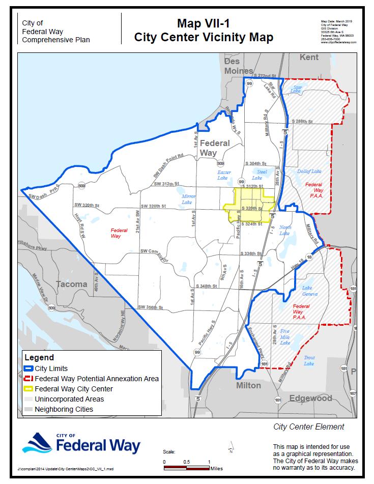
38
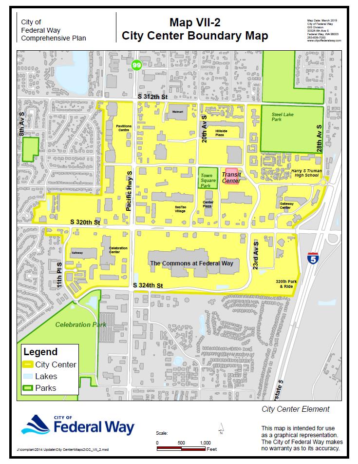
39
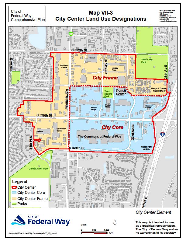
40
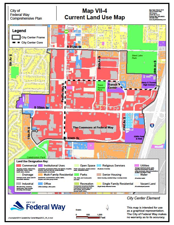
41
42

43

44
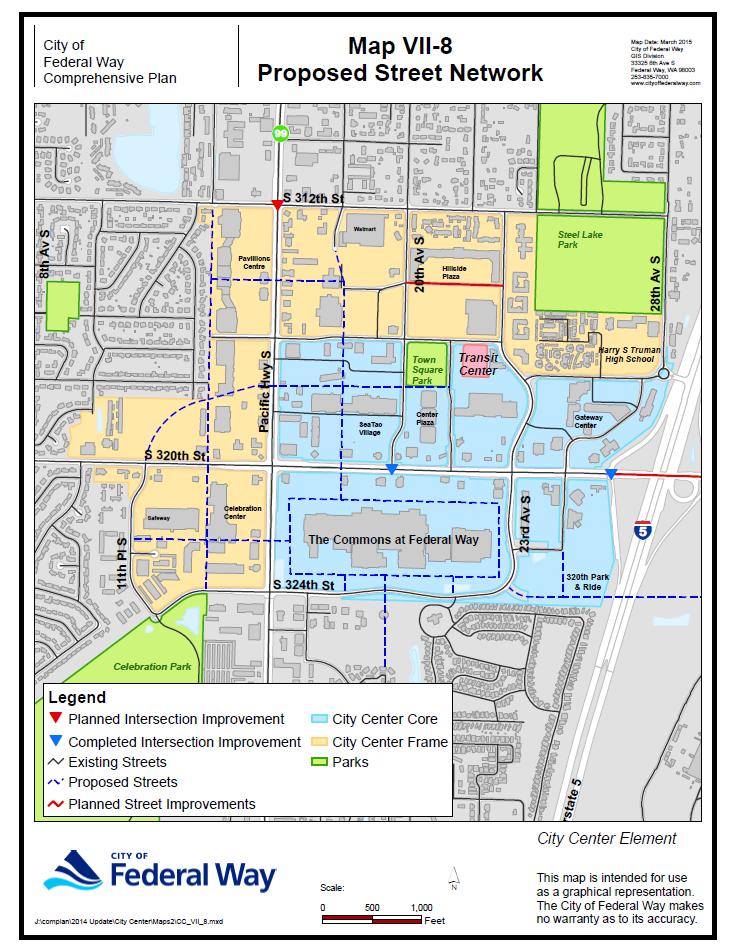
45
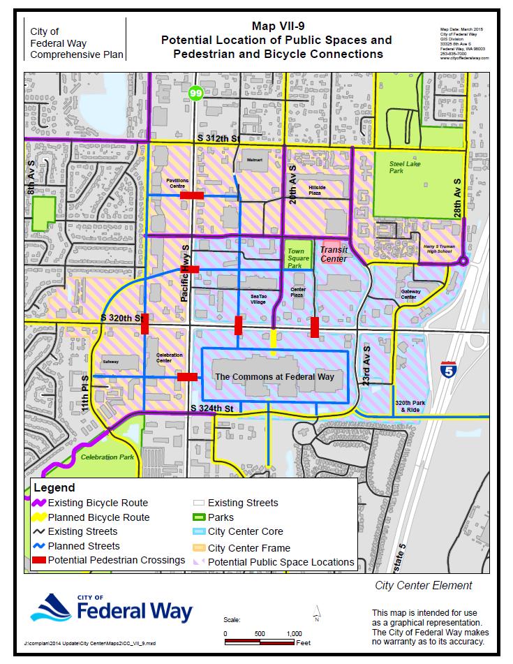
46
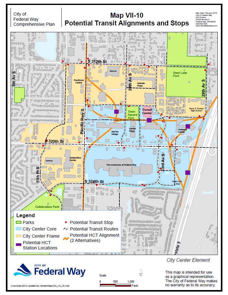
47
Transportation. Strategies for Action
 Transportation A major priority for the Overlake Neighborhood is to develop a multimodal transportation system. To achieve this system, a balance has to be found among travel, circulation and access needs;
Silverdale Regional Center
 Silverdale Regional Center Vision for Silverdale Regional Center The Silverdale Regional Center Plan (Plan) will guide the evolution of the Silverdale Regional Center from a collection of strip malls and
CHAPTER 7: Transportation, Mobility and Circulation
 AGLE AREA COMMUNITY Plan CHAPTER 7 CHAPTER 7: Transportation, Mobility and Circulation Transportation, Mobility and Circulation The purpose of the Transportation, Mobility and Circulation Chapter is to
Policies and Code Intent Sections Related to Town Center
 Policies and Code Intent Sections Related to Town Center The Town Center Vision is scattered throughout the Comprehensive Plan, development code and the 1994 Town Center Plan. What follows are sections
The Five Components of the McLoughlin Area Plan
 The Five Components of the McLoughlin Area Plan This documents contains the complete language of the five components of the McLoughlin Area Plan: The Vision Statement The Values The Guiding Principles
The University District envisions, in its neighborhood
 Envisioning the University District Link Light Rail in Seattle s neighborhoods CIY OF SEALE CONCEP-LEVEL SAION AREA PLANNING RECOMMENDAION RESOLUION # 30165 EXHIBI L Vision 08.2000 he University District
The transportation system in a community is an
 7 TRANSPORTATION The transportation system in a community is an important factor contributing to the quality of life of the residents. Without a sound transportation system to bring both goods and patrons
Chapter 1: Introduction
 Chapter 1: Introduction The Penn Avenue Community Works Corridor Vision and Implementation Framework presents an integrated communitybased vision and a coordinated, long-term implementation framework for
Table of Contents. Elm Avenue Improvement Plan City of Waco, Texas. Introduction 1. Existing Context 1 Figure 1 2.
 Table of Contents Introduction 1 Existing Context 1 Figure 1 2 Plan Guidelines 3 Future Urban Form 4 The West-End 4 Main Street 6 The East-End 7 Figure 2 9 Public Improvement Recommendations 7 General
Town Center (part of the Comprehensive Plan)
") Town Center (part of the Comprehensive Plan) Mercer Island Town Center Looking North (2014) In 1994, a year-long process culminated in a set of design guidelines and code requirements for the Town Center
Town Center (part of the Comprehensive Plan) Mercer Island Town Center Looking North (2014) In 1994, a year-long process culminated in a set of design guidelines and code requirements for the Town Center
C. Westerly Creek Village & The Montview Corridor
 C. Westerly Creek Village & The VISION Community Vision When the goals of the city are achieved Westerly Creek Village, a distinctive community defined by Montview Boulevard and Westerly Creek, is a strong
CHAPTER 3 VISION, GOALS, & PLANNING PRINCIPLES. City of Greensburg Comprehensive Plan. Introduction. Vision Statement. Growth Management Goals.
 CHAPTER 3 VISION, GOALS, & PLANNING PRINCIPLES Introduction The Greensburg Comprehensive Plan is intended as a working community document. A combination of long and short-term goals, this document is intended
SPRINGHILL LAKE TRANSIT VILLAGE
 Greenbelt Metro Area Sector Plan - Subarea Design Policies and Guidelines - Springhill Lake Transit Village 113 SPRINGHILL LAKE TRANSIT VILLAGE Residential Neighborhood and Village Center CONCEPT Springhill
Chapter 4. Linking Land Use with Transportation. Chapter 4
 Chapter 4 Linking Land Use with Transportation Chapter 4 59 Chapter 4 Linking Land Use with Transportation Community Design and Transportation Program Introduction Since the 1950s, the predominant development
4- PA - LD - LIVELY DOWNTOWN. LD - Background
 4- PA - LD - LIVELY DOWNTOWN LD - Background The downtown has been the service centre for the community since the city s inception and the area continues to supply people with their personal services,
Gold Line Bus Rapid Transit Transit Oriented Development (BRTOD) Helmo Station Area Plan
 Helmo Station Area Plan") Appendix F Gold Line Bus Rapid Transit Transit Oriented Development (BRTOD) Helmo Station Area Plan Introduction and Purpose of the Plan The Gold Line Bus Rapid Transit facility is an eleven-mile dedicated
Appendix F Gold Line Bus Rapid Transit Transit Oriented Development (BRTOD) Helmo Station Area Plan Introduction and Purpose of the Plan The Gold Line Bus Rapid Transit facility is an eleven-mile dedicated
Plano Tomorrow Vision and Policies
 Plano Tomorrow Vision and Policies PLANO TOMORROW PILLARS The Built Environment The Social Environment The Natural Environment The Economic Environment Land Use and Urban Design Transportation Housing
EXISTING COMPREHENSIVE PLAN
 EXISTING COMPREHENSIVE PLAN Town Center Land Use Element: V. LAND USE POLICIES Town Center Mercer Island's business district vision as described in "Your Mercer Island Citizen-Designed Downtown" was an
Strategic Growth Area #1 Northampton Boulevard Corridor Area
 Strategic Growth Area #1 Northampton Boulevard Corridor Area Description Strategic Growth Area #1 has established itself as a major employment center in Southside Hampton Roads. Opportunities exist to
CITY OF PUYALLUP. Background. Development Services
 CITY OF PUYALLUP Development Services 333 South Meridian Puyallup WA 98371 To: City Council From: Katie Baker, AICP, Planning Division Re: South Hill Neighborhood Plan Adoption Date: (Meeting date: February
FUTURE LAND USE ELEMENT
 FUTURE LAND USE ELEMENT GOAL I: To create and sustain a great place to live, play, and prosper Objective 1: The City of Ocala shall incorporate the principles and strategies of the Ocala 2035 Vision into
Today Land & People. Northeast Nampa Gateway District. Employment. Land Use Characteristics. Demographics. Current Zoning
 Today Land & People Employment Major employers include Saint Alphonsus, the College of Western Idaho, the Auto Mall, Sorrento Lactalis and Walmart. 3,004 jobs in 2010 (COMPASS-CIM 2040 TAZ data) 4,345
Subregion 4 Central Avenue-Metro Blue Line Corridor Transit-Oriented Development (TOD) Implementation Project. Community Meeting April 27, 2011
 Implementation Project. Community Meeting April 27, 2011") Subregion 4 Central Avenue-Metro Blue Line Corridor Transit-Oriented Development (TOD) Implementation Project Community Meeting April 27, 2011 Overview Introduction to Subregion 4 TOD Implementation Program
Subregion 4 Central Avenue-Metro Blue Line Corridor Transit-Oriented Development (TOD) Implementation Project Community Meeting April 27, 2011 Overview Introduction to Subregion 4 TOD Implementation Program
City of Hermosa Beach Administrative Policy #
 City of Hermosa Beach Administrative Policy # SUBJECT: Living Streets Policy Date: Approved by: City Council Authority: Public Works Department & Community Development Department Mayor, PURPOSE The City
hermitage town center
 hermitage town center A Community Vision prepared by Strada for The City of Hermitage and The Mercer County Regional Planning Commission January 2007 table of contents introduction 3 design principles
CHAPTER 7: VISION AND ACTION STATEMENTS. Noble 2025 Vision Statement
 CHAPTER 7: VISION AND ACTION STATEMENTS This chapter presents the vision, policy and action statements that transform the comprehensive planning study, an analysis of Noble s past, future trends and community
Lehigh Acres Land Development Regulations Community Planning Project
 Lehigh Acres Land Development Regulations Planning Effort Summary In July, 2010 Commissioner Frank Mann invited the Lehigh Acres community to start discussing how to achieve their recently adopted community
Metro. Activity Center Design Guidelines. Recommendations For Developing Focused, Mixed-Use Commercial/Residential Centers
 Metro Activity Center Design Guidelines Recommendations For Developing Focused, Mixed-Use Commercial/Residential Centers Metro Activity Centers What is a MAC? Legacy, the adopted guide for the future growth
MALL REVITALIZATION CASE STUDIES
 MALL REVITALIZATION CASE STUDIES DECEMBER 9, 2012 MALL REVITALIZATION OVERVIEW Introduction Sample Case Studies prepared for Lacey Woodland District Steering Committee as it considers strategies to revitalize
PSRC REVIEW REPORT & CERTIFICATION RECOMMENDATION
 PSRC REVIEW REPORT & CERTIFICATION RECOMMENDATION KITSAP COUNTY COUNTYWIDE PLANNING POLICIES July 2, 2012 BACKGROUND A major emphasis of the Washington State Growth Management Act (GMA) is the need to
Hockessin Community Redevelopment Plan
 Hockessin Community Redevelopment Plan 3.1 Introduction The Community Redevelopment Plan for the Village of Hockessin is the result of the people s vision for a distinct village center that serves as the
TRANSPORTATION ELEMENT GOALS, OBJECTIVES, AND POLICIES
 TRANSPORTATION ELEMENT GOALS, OBJECTIVES, AND POLICIES GOAL 2 The City shall provide a safe, convenient, effective, and energy efficient multimodal transportation system which is coordinated with the Future
Corridor Vision. 1Pursue Minnehaha-Hiawatha Community Works Project. Mission of Hennepin County Community Works Program
 1Pursue Minnehaha-Hiawatha Community Works Project Minnehaha-Hiawatha Community Works is a project within the Hennepin Community Works (HCW) program. The mission of the HCW program is to enhance how the
RESOLUTION NO. R Refining the route, profile and stations for the Downtown Redmond Link Extension
 RESOLUTION NO. R2018-32 Refining the route, profile and stations for the Downtown Redmond Link Extension MEETING: DATE: TYPE OF ACTION: STAFF CONTACT: Capital Committee Board PROPOSED ACTION 09/13/2018
Neighborhood Districts
 NEIGHBORHOOD DISTRICTS SEVEN MAIN DISTRICTS Neighborhood Districts While the Development Plan provides a broad-scale overview of the neighborhood, this section focuses on uses and relationships at the
Growth Management Planning in the Central Puget Sound Region. Today s Presentation. Puget Sound Region. New Partners for Smart Growth
 Growth Management Planning in the Central Puget Sound Region New Partners for Smart Growth Denver, CO January 2006 Today s Presentation Regional growth management in central Puget Sound, WA Regional geographies
DRAFT Land Use Chapter
 Stevens Creek Urban Village DRAFT 1 18 17 Land Use Chapter INTRODUCTION This Land Use Chapter describes how the Stevens Creek Urban Village will accommodate the growth that is planned for it in the Envision
Appendix C: Interim Mixed-Use Evaluation Criteria
 Appendix C: Interim Mixed-Use Evaluation Criteria C-1 Appendix C: Interim Mixed-Use Evaluation Criteria PURPOSE: The implementation of numerous policies contained within the Master Plan hinges on the creation
A Plan for the Heart of the Region: Tukwila, WA
 : Tukwila, WA 1 The Plan orchestrates the Restructuring of a 1,000-acre Regional Shopping Area into a Social and Symbolic for the Region. REGIONAL CONTEXT Downtown Seattle (Metropolitan ) 20 miles Bellevue
LAND USE OVERVIEW WHAT YOU WILL FIND IN THIS CHAPTER
 LAND USE WHAT YOU WILL FIND IN THIS CHAPTER Information about the City s expected population and employment growth. Description and capacity of existing and future land use designations. Policies that
Sheridan Boulevard S TAT I O N A R E A P L A N S H E R I D A N B O U L E VA R D S TAT I O N A R E A P L A N
 Sheridan Boulevard S TAT I O N A R E A P L A N 1 City of Lakewood Adopted November, 2006 S H E R I D A N B O U L E VA R D S TAT I O N A R E A P L A N The Vision The City of Lakewood s overall vision is
Planning Districts INTRODUCTION
 INTRODUCTION To facilitate detailed examination of development prospects for all areas of the community, Delano has been divided into 14 planning districts. The location of these planning districts is
COMMUNITY DESIGN. GOAL: Create livable and attractive communities. Intent
 COMMUNITY DESIGN Intent An attractive, well-designed County will attract quality development, instill civic pride, improve the visual character of the community, and create a strong, positive image for
178 Carruthers Properties Inc.
 178 Carruthers Properties Inc. Planning Rationale for 178 Carruthers Avenue Site Plan Control Application June 2014 Table of Contents 1.0 Introduction 2.0 Overview of Subject Property 3.0 Current Zoning
City of Farmington. Downtown Plan. Amendment to the 1998 Master Plan Adopted October 11, 2004
 City of Farmington Amendment to the 1998 Master Plan Adopted October 11, 2004 Introduction Planning Background 1 Scope and Components of the Plan Amendment 2 Concept Introduction 3 Plan Concepts 3 Conceptual
Urban Design Manual PLANNING AROUND RAPID TRANSIT STATIONS (PARTS) Introduction. Station Study Areas
 Introduction. Station Study Areas") 111111 PLANNING AROUND RAPID TRANSIT STATIONS (PARTS) Introduction The ION rapid transit system will link Waterloo, Kitchener and Cambridge through a central transit corridor (CTC). There are a number
111111 PLANNING AROUND RAPID TRANSIT STATIONS (PARTS) Introduction The ION rapid transit system will link Waterloo, Kitchener and Cambridge through a central transit corridor (CTC). There are a number
THE 355/270 CORRIDOR:
 THE 355/270 CORRIDOR: Strategic Ideas for Sustaining a Livable Work Place Project Summary ACCESS LIFE DESIGN HEALTH WORK Montgomery County Planning Department The Maryland-National Capital Park and Planning
Chapter 1.0 Introduction
 Chapter 1.0 Introduction 1.1 Background The North Metro commuter rail line is part of the RTD FasTracks regional transit system expansion program to build more than 100 miles of rail transit throughout
CHAPTER 1. Ms. Guajardo s Class - Central Elementary CH 1 1
 INTRODUCTION CHAPTER 1 Ms. Guajardo s Class - Central Elementary CH 1 1 1.1 SETTING South Centre City is a linear corridor south of Downtown Escondido paralleling Centre City Parkway and South Escondido
Windsor Locks Transit-Oriented Development Planning Grant Request. Project Background
 Windsor Locks Transit-Oriented Development Planning Grant Request Project Background Downtown Windsor Locks runs along Main Street in the vicinity of the intersection of Routes 159 and 140. The current
VISION, GOALS & CONCEPT DIAGRAM 2.0
 CHAPTER 2.0 2.1 Vision Creation Process 2.2 City Center Vision Statement, Goals and Objectives 2.3 Individual Zone Visions 2.4 Steps in City Building 2.5 Urban Form Concept Diagram for City Center VISION,
Additional information about land use types is given in Chapter 5. Design guidelines for Centers and Neighborhoods are given in Chapter 7.
 4. Place Types Introduction In Albemarle County s Development Areas, the Neighborhood is the fundamental unit of community planning. The County s Neighborhood Model, an adopted part of the Comprehensive
Executive Summary. NY 7 / NY 2 Corridor
 Executive Summary NY 7 / NY 2 Corridor Transportation and Land Use Study December 2005 Prepared for: Town of Colonie Capital District Transportation Committee Prepared by: Introduction: Land use decisions
Cumberland Region Tomorrow is a private, non-profit, citizen based regional organization working with Greater Nashville Regional Council
 Cumberland Region Tomorrow is a private, non-profit, citizen based regional organization working with Greater Nashville Regional Council and others in the public and private sectors, dedicated to planning
3.1 community vision. 3.3 required plan elements
 Chapter 3 Community Form 3.1 community vision 3.2 Parks & landscaping concepts 3.3 required plan elements D R A F T 20 Community Form Chapter 3 3.0 Community form 3.1 community vision The Specific Plan
The West Vaughan Employment Area Secondary Plan Policies
 Part 2: The West Vaughan Employment Area Secondary Plan Policies 2.1 General Policies It is the policy of Council: 2.1.1. That the West Vaughan Employment Area (the WVEA), identified on Schedule 1, will
Wadsworth Boulevard S TAT I O N A R E A P L A N
 Wadsworth Boulevard S TAT I O N A R E A P L A N City of Lakewood Adopted November, 2006 The Vision The City of Lakewood s overall vision is to transform the area around the light rail station into a mixed-use
TRANSIT ORIENTED DEVELOPMENT PINELLAS COUNTY MPO LIVABLE COMMUNITIES INITIATIVE PINELLAS COUNTY COMPREHENSIVE PLAN AMENDMENTS
 PINELLAS COUNTY MPO LIVABLE COMMUNITIES INITIATIVE MODEL LAND DEVELOPMENT CODE TRANSIT ORIENTED DEVELOPMENT PINELLAS COUNTY COMPREHENSIVE PLAN AMENDMENTS MPO Livable Communities Initiative Goal: Improve
6. DOWNTOWN. The Downtown Element focuses on supporting and expanding the vitality and enhancement of Downtown Chico as the City s central core.
 VISION In 2030, Downtown Chico is the heart of the community and the center of cultural activity. Engaging and active at the street level, it is a multi-story, mixed-use hub, with specialty retail, restaurants,
1 Adapted from the Statewide Transit-Oriented Development Study by CalTrans, 2006
 APPENDIX C: LAND USE PLANNING FOR ENHANCED RAIL SERVICE 72 BACKGROUND One of the consistent themes heard from localities in the Route 29 corridor Planning Forums was the need for expanding rail service
Economy Vision Statements: Social Wellbeing Vision Statements: Natural Environment Vision Statements:
 Economy Vision Statements: 1. Our business environment makes us a region of choice for new employers as we encourage entrepreneurship and have a vibrant, diversified and resilient regional economy. 2.
New Partners for Smart Growth Conference February 5, 2010
 Dan Stroh, Planning Director City of Bellevue Planning and Community Development Bellevue, WA New Partners for Smart Growth Conference February 5, 2010 Summary of Project Long-range plan update for Bel-Red
Robbinsdale LRT Station. CDI Development Guidelines. August Overview
 Robbinsdale LRT Station August 2018 Overview The City of Robbinsdale may have the coolest opportunity site along the 13 mile stretch of the Bottineau LRT corridor / Blue Line extension. Located a block
REGIONAL ACTIVITY CENTER
 DRAFT REGIONAL ACTIVITY CENTER 70 EAST BENCH MASTER PLAN DRAFT 06 Introduction The East Bench Regional Activity center is comprised of large educational, research, medical, and employment centers. These
Be it enacted by the Town Board of the Town of Guilderland that the following new A (Transit Oriented Development (TOD) District) is adopted:
 District) is adopted:") Local Law No. 4 of 2018 (Adoption of 280-18A (Transit Oriented Development District) Be it enacted by the Town Board of the Town of Guilderland that the following new 280-18A (Transit Oriented Development
Local Law No. 4 of 2018 (Adoption of 280-18A (Transit Oriented Development District) Be it enacted by the Town Board of the Town of Guilderland that the following new 280-18A (Transit Oriented Development
Downtown Dubuque...it s a great time.
 Downtown Dubuque...it s a great time. Your timing could not be better to invest in Downtown. With hundreds of millions in public and private investment occurring on the City s downtown waterfront, millions
DALY CITY VISIONING PROCESS COMMUNITY WORKSHOP 3 MAY 8, 2008
 DALY CITY VISIONING PROCESS COMMUNITY WORKSHOP 3 MAY 8, 2008 PROCESS General Plan - a statement of the community s values, vision and aspirations for now and into the future... Timeframe LONG TERM - 2030
Living in Albemarle County s Urban Places
 Living in Albemarle County s Urban Places ALBEMARLE COUNTY, VIRGINIA A Closer Look at Albemarle s Approach to Managing Growth and Creating Quality Urban Environments www.albemarle.org Page 2 Living in
Concord Community Reuse Project Goals and Guiding Principles. Overarching Goals (OG)
") Concord Community Reuse Project Goals and Guiding Principles Overarching Goals (OG) No priority is implied by the order of presentation of the goals and guiding principles. Overarching goals for the Concord
Concord Community Reuse Project Goals and Guiding Principles Overarching Goals (OG) No priority is implied by the order of presentation of the goals and guiding principles. Overarching goals for the Concord
greenprint midtown SUSTAINABILITY ACTION PLAN 2012
 greenprint midtown SUSTAINABILITY ACTION PLAN 2012 MIDTOWN ALLIANCE SOUTHFACE ENERGY INSTITUTE RENAISSANCE PLANNING GROUP SUSTAINABLE ATLANTA PERKINS+WILL 2 GREENPRINT MIDTOWN 1. Introduction Sustainability
3. ELEMENTS OF THE METRO VISION 2035 PLAN
 3. ELEMENTS OF THE METRO VISION 2035 PLAN What is Metro Vision and why does it matter? For more than 50 years, DRCOG has championed a regional perspective on key issues facing the metropolitan area and
Comprehensive Plan ADOPTED APRIL 2014
 Comprehensive Plan ADOPTED APRIL 2014 8 8. Outstanding Recreational & Cultural Opportunities We are proud of our community s parks and recreation system. Our community will ensure that the legacy of our
PINE CURVE REZONING. Property does not meet criteria for open space preservation and is not a candidate for a park
 PINE CURVE REZONING BACKGROUND Purchased as two parcels in 2001 and 2002 Annexed and Zoned Greater Downtown District Historic Center September 25, 2002 and October 7, 2002 WHAT THE PROJECT IS AND IS NOT
Draft Memorandum #1: Goals and Vision for Revitalization
 Keizer Revitalization Plan Draft Memorandum #1: Goals and Vision for Revitalization Submitted to: City of Keizer April 12, 2018 (revised) Prepared By: Angelo Planning Group and Otak, Inc. Project No. 17482.A
Complete Neighbourhood Guidelines Review Tool
 Complete Neighbourhood Guidelines Review Tool Prepared By: City of Regina Planning Department October 2014 Page 1 of 14 Community Development Review Checklist for Secondary Plans and Concept Plans The
THEMES, VISION, + PRINCIPLES
 CHAPTER 2: THEMES, VISION, + PRINCIPLES This page intentionally left blank. 20 VISION DRAFT AUGUST 2018 2 2 THEMES, VISION, + GUIDING PRINCIPLES The Key Themes, Vision, and Guiding Principles presented
Issues Requiring Future Study
 Issues Requiring Future Study Transportation planning is an ongoing process that tends to identify new issues as it finds solutions for others. Some issues are so complex that a solution to one problem
V. Vision and Guiding Principles
 V. Vision and Guiding Principles The Master Plan for the Powers Ferry Corridor seeks a foundation in the desires of the community. At times, various elements of the community offered opposing viewpoints,
DRAFT City of Titusville 2040 Comprehensive Plan Future Land Use, Housing, and Transportation Elements April 16, 2018
 DRAFT City of Titusville 2040 Comprehensive Plan Future Land Use, Housing, and Transportation Elements April 16, 2018 Prepared by Canin Associates for the City of Titusville About the Comprehensive Plan:
HE VISION. Building a Better Connected Place
 HE VISION Building a Better Connected Place WALK INTO THE FUTURE. Life in Cranberry, 2030 Here s what our residents told us they wanted to see in their community by 2030: The Cranberry of 2030 is a place
ELMVALE ACRES SHOPPING CENTRE MASTER PLAN
 ELMVALE ACRES SHOPPING CENTRE MASTER PLAN Contents 1.0 INTRODUCTION... 2 2.0 LOCATION... 2 3.0 EXISTING CONTEXT... 2 4.0 VISION & GUIDING PRINCIPLES... 2 5.0 LAND USE AND BUILT FORM... 4 5.1 St. Laurent
Description of Preferred Alternative
 Chapter 2 Description of Preferred Alternative 2.1 Introduction This chapter of the programmatic Sammamish Town Center Sub-area Plan Final EIS provides a more detailed description of the Preferred Alternative
ELK GROVE GENERAL PLAN VISION
 2-1 CHAPTER 2: 2-2 CREATING OUR The Community Vision for Elk Grove, expressed through a Vision Statement and a series of Supporting Principles, is a declaration of the kind of community that Elk Grove
4.1.3 LAND USE CATEGORIES
 4.1.3 LAND USE CATEGORIES a. City Center District The City Center District incorporates the existing character and mix of uses in downtown Belmont to encourage redevelopment and new development in keeping
4. Shape Transitions. 4. Shape Transitions
 4. Shape Transitions 49 Zoning District Policies Overall Intent: Maintain neighborhood character by creating compatible transitions that minimize land use conflicts. Strategy: Define the character of zoning
EXHIBIT A. Tax Increment Reinvestment Zone No. 1 (Town Center) First Amended Project Plan 1
 First Amended Project Plan 1") EXHIBIT A Tax Increment Reinvestment Zone No. 1 (Town Center) First Amended Project Plan 1 1 As amended by Resolution No. 2008-02-001(TR1R) of the Tax Increment Reinvestment Zone No.1, and approved to
EXHIBIT A Tax Increment Reinvestment Zone No. 1 (Town Center) First Amended Project Plan 1 1 As amended by Resolution No. 2008-02-001(TR1R) of the Tax Increment Reinvestment Zone No.1, and approved to
1.0 VISION STATEMENT. December 6, PRINCIPLES
 Vision Statement Lincoln Regional Airport 1.0 VISION STATEMENT 1.1 City LOCATION of AND OVERVIEW The Easton Lincoln Place Land Use Master Plan identifies the principles, goals, policies, and standards
City of Tacoma Planning and Development Services
 Agenda Item E-1 City of Tacoma Planning and Development Services To: Planning Commission From: Elliott Barnett, Planning Services Division Subject: Tacoma Mall Regional Center Subarea Plan and EIS Meeting
Northwest Rail Corridor and US 36 BRT Development Oriented Transit Analysis 4.4 STATION AREA FINDINGS
 4.4 STATION AREA FINDINGS Each station is different, and each one requires a separate set of recommendations based on the vision for the site. This section outlines an initial TOD strategy and recommendations
S A C R A M E N T O C O U N T Y JACKSON HIGHWAY & GRANT LINE EAST VISIONING STUDY
 JACKSON HIGHWAY & GRANT LINE EAST S A C R A M E N T O C O U N T Y P L A N N I N G D E P A R T M E N T SUMMARY AND WORKBOOK November 19, 2008 History of the Visioning Study Sacramento County has two growth
City of Long Beach. creating vibrant and exciting places
 City of Long Beach creating vibrant and exciting places Land Use Element Urban Design Element Overview of the two draft General Plan elements Discuss areas of change Economic goals of the plans Case study
Land Use Amendment in Southwood (Ward 11) at and Elbow Drive SW, LOC
 at and Elbow Drive SW, LOC") 2018 November 15 Page 1 of 10 EXECUTIVE SUMMARY This land use amendment application was submitted by Rick Balbi Architect on 2017 August 31 on behalf of Sable Developments Ltd, and with authorization from
2018 November 15 Page 1 of 10 EXECUTIVE SUMMARY This land use amendment application was submitted by Rick Balbi Architect on 2017 August 31 on behalf of Sable Developments Ltd, and with authorization from
CONTENTS 8.0 LAND USE 8.1 GENERAL LAND USE 8.2 RESIDENTIAL 8.3 MIXED USE 8.4 COMMERCIAL 8.5 EMPLOYMENT LANDS
 8-2 Land Use 8.0 LAND USE CONTENTS 8.1 GENERAL LAND USE 8.1.1 Uses provided for in all Land Use Designations 8.1.2 Uses prohibited in Hazardous Lands, Hazardous Sites and Special Policy Areas 8.1.3 Uses
PINE CURVE REZONING. BACKGROUND Purchased as two parcels in 2001 and 2002
 BACKGROUND Purchased as two parcels in 2001 and 2002 WHAT THE PROJECT IS AND IS NOT A Rezoning establishes the land use standards for Annexed and Zoned Greater Downtown District Historic Center September
SECTION ONE: INTRODUCTION. introduction
 introduction 1 INTRODUCTION Since it was first established in 1843 as a trading post for the Hudson s Bay Company, Victoria has evolved into a Provincial capital city that is recognized across Canada and
Northwest commuter rail station US 36 BRT. Westminster Station
 Northwest commuter rail station Westminster Station US 36 BRT Westminster Center US 36 & Church Ranch Broomfield Flatiron/96 th St. US 36 & McCaslin Table Mesa Boulder Junction 13-month effort that will
CHAPTER 2: FUTURE LAND USE CONCEPTS
 CHAPTER 2: FUTURE LAND USE CONCEPTS INTRODUCTION The future land use concepts presented in this chapter are an expression of community support for a viable and vital US 50 Corridor. Land use recommendations
Visioning Statement and Guiding Principles
 Visioning Statement and Guiding Principles Planning for the Future The General Plan The General Plan represents Woodland's shared vision of the future and defines a path to lead the community toward its
VILLAGE OF ROMEOVILLE
 VILLAGE OF ROMEOVILLE COMPREHENSIVE PLAN FRAMEWORK PLAN, KEY STRATEGIES & GUIDING PRINCIPLES December 8, 2016 KEY PLANNING THEMES 2 KEY PLANNING THEME #1 ADVANCING A BALANCED ECONOMIC BASE KEY PLANNING
and services The protection and conservation of environmentally significant and sensitive natural heritage features and functions.
 6. Land Use 6.0 Preamble A healthy and livable city is one in which people can enjoy a vibrant economy and a sustainable healthy environment in safe, caring and diverse neighbourhoods. In order to ensure