Kaskitayo Outline Plan
|
|
|
- Christiana Montgomery
- 5 years ago
- Views:
Transcription
1 Kaskitayo Outline Plan Office Consolidation June 2017 Prepared by: City Planning Branch Sustainable Development City of Edmonton The Kaskitayo Outline Plan was approved by resolution by Council in October In June 2017, this document was consolidated by virtue of the incorporation of the following amendments: Kaskitayo Outline Plan approved by resolution October 23, 1973 Amendment approved by resolution January 26, 2005 (to replace intensive commercial development with the intensive redevelopment of a transit-oriented urban village with primarily residential uses complemented by commercial uses in a pedestrian friendly environment) Amendment approved by resolution December 12, 2006 (to accommodate the development of housing for first homebuyers on a vacant surplus school building envelope located on a school/park site) Amendment approved by resolution August 30, 2010 (to redesignate a Highway Commercial use site to Mixed Use Residential uses to allow for the development of a 19 storey building) Amendment approved by resolution October 15, 2012 (to accommodate Medium Density Residential uses for seniors housing on surplus school building envelope located on a school/park site) Amendment approved by resolution November 2, 2015 (to accommodate Medium Density Residential uses for a low rise apartment development on the radio transmitter tower site) Amendment approved by resolution December 14, 2015 (to accommodate Medium Density Residential uses for low rise apartment and row housing development on an area equal to the vacant surplus school building envelopes of two school sites in Blue Quill) Amendment approved by resolution on June 12, 2017 (to accommodate changes to the urban village concept including overall street and block layout and density) Editor s Note: This is an office consolidation edition of the Kaskitayo Outline as approved by resolution by City Council on October 23, This edition contains all amendments and additions to the Outline Plan. For the sake of clarity, new maps and a standardized format were utilized in this Plan. All names of City departments have been standardized to reflect their present titles. Private owners names have been removed in accordance with the Freedom of Information and Protection of Privacy Act. Furthermore, all reasonable attempts were made to accurately reflect the original Outline Plan. All text changes are noted in the right margin and are italicized where applicable. This office consolidation is intended for convenience only. In case of uncertainty, the reader is advised to consult the original plan, available at the office of the City Clerk. City of Edmonton Sustainable Development
2 KASKITAYO OUTLINE PLAN THE CITY OF EDMONTON. by UNDERWOOD McLELLAN AND ASSOCIATES LIMITED Edmonton, Alberta May, 1974
3 KASKITAYO OUTLINE PLAN FORWARD This document is a consolidation of the original outline plan report prepared for the Kaskitayo Area in February 1971 and the addendum to the report prepared in November The original Kaskitayo Outline Plan and the Addendum to that report were based on the guidelines set out by the City Planning Department in their report: entitled "Kaskitayo Outline Plan - Development Policy and Guidelines Report". The Kaskitayo Outline Plan, together with the Addendum to that report, received Municipal Planning Commission conditional approval February 15th, 1973 and City Council approval on October 23rd, Council approval contained two amendments as follows: 1. The maximum overall density shall be 22 persons per gross acre (54.34 persons per gross hectare). 2. The destination of 111th Street be left in abeyance pending Council's determination of this facility as part of the transportation plan. This consolidated document represents the final outline plan report. The information contained herein forms the basics for further detailed planning of the Kaskitayo Area.
4 TABLE OF CONTENTS () INTRODUCTION AND BACKGROUND 1 I. THE URBAN CONTEXT OF THE KASKITAYO AREA 4 A. Relationships 4 B. External Access 7 II. EXISTING SITE CONDITIONS WITH RESPECT TO LAND USE 8 A. Natural Features 8 B. Existing Land Use 11 C. Land Ownership 12 D. Utilities 14 E. Zoning 15 III. OBJECTIVES FOR THE KASKITAYO DISTRICT 16 A. General Considerations The Purpose of the Outline Plan Residential Development and Population Transportation and Servicing Special Study Area South of Blackmud Ravine 17 B. Special Objectives Residential Schools and Open Space Commercial Development Vehicular Circulation Public Transportation Pedestrian Circulation 22
5 IV. DEVELOPMENT OF THE OUTLINE PLAN 24 A. The General Order of the Plan Neighbourhoods Communities District 24 B. Procedure for Development of the Plan Arterial Roads and Community Divisions Collector Roads and Neighbourhood Divisions Community Facilities Urban Village High Schools and District Recreational Facilities Residential Land Use Open Space Pedestrian Walkway System Incorporation of Existing Development 38 C. Land Use Summary 39 D. Residential Development and Housing Proportions 41 E. Parks and School Sites 44 V. STAGING OF DEVELOPMENT 46 APPENDIXES Appendix A - Land Ownership 48 Appendix B - Traffic Engineering Analysis 52 Appendix C - Land Use Statistics 56
6
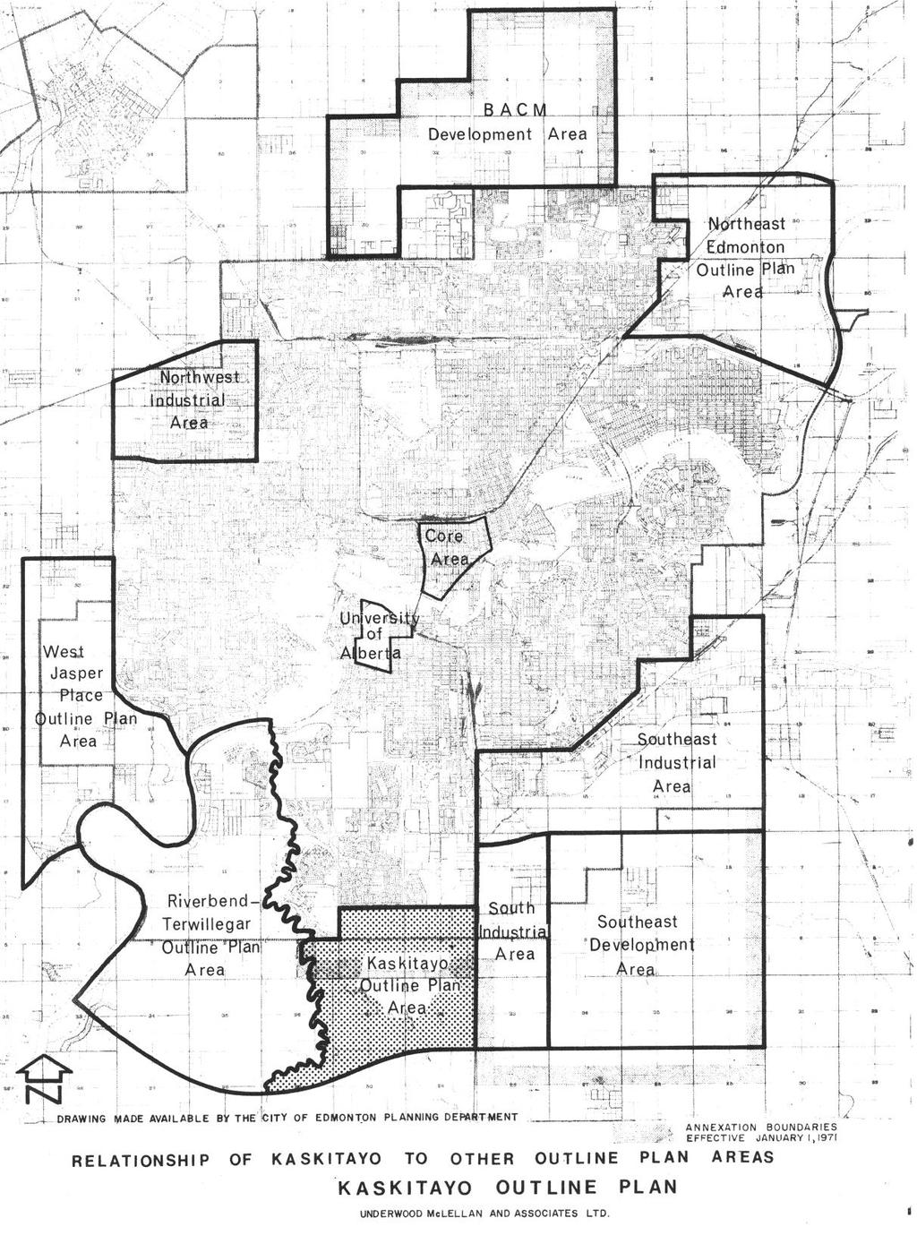
7 Notwithstanding any part or policy of this Plan, an opportunity to develop housing for first time homebuyers exists on a vacant surplus school building envelope on the school/park site located at Saddleback Road, west of 112 Street, and at the southwest corner of 105 Street and 16 Avenue and as specified under the Community Services Zone. The Community Services Zone reflects the underlying, pre-existing zoning and will, in addition, allow for row housing and related accessory uses. The housing opportunity will occur on an area equal to the portion of the surplus school building envelope. The precise location of this housing within the entire School/Park site will be reviewed and determined by the City. The dwelling units and population generated by this development under the Community Zone are not included in the statistical summary. The school/park site is amended to include the opportunity for medium density housing for seniors on the surplus school building envelope. The precise location of this housing within the entire School/Park site will be determined by the City. The dwelling units and population generated by this development are not included in the land use and population statistics. December 12, 2006 October 15, 2012 INTRODUCTION AND BACKGROUND This document is concerned with the Kaskitayo Planning area and takes the form of an outline plan as follow up to the Kaskitayo Development Policy and Guidelines Report recently prepared by City of Edmonton Sustainable Development. The purpose of an outline plan is to show the general pattern of development for a large area of land. The Plan designates those parts intended for various land uses, the provisions to be made for services and utilities, and the basic vehicular and pedestrian circulation patterns. The Kaskitayo Outline Plan has been prepared to assist in the orderly and economic growth of the City of Edmonton and, more specifically, to form the basis from which detailed land development plans may be determined. The Kaskitayo Outline Plan area is situated in the south west sector of the City. Plate 1 indicates the relationship of Kaskitayo to other outline plan areas and also shows its general location. It is evident that Kaskitayo forms an important link in the completion of an overall comprehensive development pattern for the southern suburban portion of the City. It is one of a series of outline plans which have been completed or which are currently being prepared. 1
8 This outline plan has been prepared by the consulting firm of Underwood McLellan and Associates Limited representing a number of land owners and developers in the Kaskitayo area. Numerous meetings between staff of the Sustainable Development and other City Departments have been held in order to ensure that the full range of public needs has been considered and that a desirable living environment is created, based upon acceptable standards and criteria. The Kaskitayo Development Policy and Guidelines Report indicates, in considerable detail, the general background to the preparation of the outline plan. It contains two main parts: 1. A survey and analysis of existing physical plant together with a summary of the implications of these features; and 2. A presentation of the basic standards, requirements and policies which should be utilized when the final outline plan document is prepared. These policies and guidelines have had a direct influence on the form of development proposed in this outline plan. It is, therefore, important that the Planning Department report be reviewed in conjunction with this Kaskitayo Outline Plan Report. Fundamentally, the Kaskitayo outline plan presents a proposal concerning how expansion should proceed in the future, recognizing objectives and generally accepted principles relating to orderly development. It forms a framework upon which detailed subdivision plans may be based and ensures that major public facilities such as schools, shopping centres and arterial roadways are located in the best possible manner and that the best living environment is created. The features of the Kaskitayo area, discussed at greater length in a later section of this report, indicate that this area will be suitable for residential and related development. At the present time, there is an established social and economic need for serviced land in the southern area of Edmonton which can provide a broad range of housing choices. Many of the required services and facilities needed to satisfy this need are located in or adjacent to the Kaskitayo area. In view of these and other factors contained herein, the Kaskitayo Outline Plan has been prepared to guide the development of this area in a manner which will respond to this established need. 2
9 3
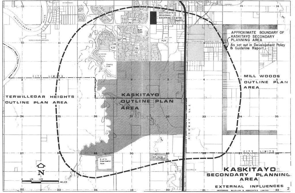
10 I. THE URBAN CONTEXT OF THE KASKITAYO AREA A. Relationships The Kaskitayo Outline Plan Area, as illustrated on Plate No. 1 lies in the southern portion of the Metropolitan Edmonton Area, to the East of Riverbend-Terwillegar Heights with Whitemud Creek forming a common area. The Outline Plan Area is bounded by specific developments and/or land uses in all directions. As indicated on Plate No. 2 these are: 1. The present No. 2 Highway (Calgary Trail) in conjunction with the railway right-of-way forms the logical limit to the development to the East and acts as a division between residential and proposed industrial use. The southeast residential development area (Mill Woods) is located one mile east of the No. 2 Highway (Calgary Trail) and immediately opposite the Kaskitayo development area. The southwestern limit of the Strathcona Industrial park is contiguous to the Kaskitayo Outline Plan area on the northeast. 2. The Greenfield and Duggan residential communities are immediately adjacent to the Kaskitayo area on the north and subdivision plans for these areas overlap into the Kaskitayo Plan Area to the line of 34th Avenue. The Derrick Club Golf Course and the Westbrook Estate residential area are situated immediately adjacent to the northwest corner of the Kaskitayo area. 3. The Terwillegar Heights area is adjacent to Kaskitayo on the west with the Whitemud Creek Ravine forming a common boundary. 4. The University Experimental Farm is located in the S.E.¼ of Section 25, immediately adjacent to the southwesterly limit of the Kaskitayo Outline Plan area. An existing golf course is situated in the N.W.¼ of Section 29, approximately ½ mile south of the southern limit of the Kaskitayo Plan Area. The predominant land use south of the Kaskitayo Plan Area and west of No. 2 Highway is agricultural and is likely to remain so beyond the limits of the projected ring road. The lands included in the Kaskitayo area are all of Sections 5 and 6, in Township 52, 4
11 Range 24, all of Sections 31 and 32 and parts of Sections 29 and 30, in Township 51, Range 24 and part of Section 1 in Township 52, Range 25, all west of the 4th Meridian. The total gross develop-able area is about 2400 acres. Due to the geographical location of the Kaskitayo area an excellent relationship exists between Kaskitayo and the Edmonton City Centre and the University of Alberta. An approximate physical distance of 5 miles separates these activity centres from Kaskitayo. The area's east-west orientation to existing or proposed major industrial areas of the city will provide an excellent opportunity for a desirable living-working relationship which could have a substantial effect on casing home to work traffic will problems. Convenient access will be provided to both the existing major shopping centres, such as Southgate, as well as to the proposed town centres in newly developing areas in the south. The amenity of the Blackmud and Whitemud Ravines will aid in providing an excellent opportunity to develop an attractive residential area. The future development of Kaskitayo is primarily intended as residential, fully supported by a full range of related services such as schools, shopping centres and recreation facilities. It is anticipated that a variety of housing types will be provided within the Kaskitayo area, varying from single family dwellings to various forms of townhousing and apartment units. A broad cost range of housing, to satisfy the needs of all income groups, is anticipated. The mixture of housing types should provide an aesthetically and socially interesting variety and should satisfy a broad range of individual requirements. 5
12 6
13 B. External Access The Calgary Trail (Highway No. 2), 111th Street and 119th Street connect the Kaskitayo area to downtown Edmonton, the University of Alberta and other commercial and industrial areas on the south side of the Saskatchewan River. Only the Calgary Trail and 111th Street presently provide access to the area south of Kaskitayo. Plate No. 3 indicates the major transportation net-work as related to the proposed development of the Kaskitayo area. The main connector to districts immediately east and west of Kaskitayo is 23rd Avenue. The proposed 34th Avenue will provide access to the east only. The proposed Outer Ring Road (Anthony Henday Drive) will provide a high speed by-pass connection to industrial areas and other centres in the Greater Edmonton Region. Plans for the provision of rapid transit to south Edmonton are currently under review with several alter-natives being examined. The alignment of the rapid transit system down 111th Street to about 30th Avenue and thence eastward would provide excellent access to down-town for Kaskitayo residents. The alignment along the railway right-of-way south to 30th Avenue, or possibly continuing south to the International Airport, would not provide the same level of service to the Kaskitayo area. Additional studies have indicated that the extension of the 111th Street alignment south to 23rd Avenue and thence easterly to Mill Woods (S.E.D.A.) would provide the best level of service for the outline plan area. This consideration is discussed at greater length in a later section of this report. 7
14 II. EXISTING SITE CONDITIONS WITH RESPECT TO LAND USE This section summarizes the major existing features within the area, which have been described in greater detail in the Development Policy and Guidelines Report A. Natural Features The Blackmud Creek which generally traverses the southwesterly portion of the site and the Whitemud Creek which forms its western boundary are the most significant natural features of the area. These two ravines, which are shown on Plate No. 4, are substantial topographic features, being entrenched from 60 to over 100 feet below the top of bank. The side slopes range from 20 to 50 percent with cliff conditions occurring, particularly near their point of confluence. Both ravines contain heavy stands of forest vegetation. The remainder of the Kaskitayo area is relatively flat. Drainage is generally through the Whitemud and Blackmud Creek systems except for the easterly half of the area. For this portion the drainage is provided by a ditch running in a north-south direction, along a registered right-of-way, into the Duggan area. There are no areas of marsh or bog which would present development difficulties. The highest point in the area is located just to the east of 111th Street about a quarter mile to the south of 23rd Avenue. The area outside of the ravines has been cultivated farm land for many years. Small stands of trees occur as shelter belts around farmsteads and in a few locations along the drainage ditch. The land within the Kaskitayo area generally affords sufficient opportunity to create an attractive living, working and recreational environment, particularly when the natural features of the site are combined with careful physical design. The presence of the Whitemud and Blackmud ravines provides exceptional opportunity to achieve this end. 8
15 9

16 Power Line Power Line Power Line * 10
17 B. Existing Land Use The predominant existing land use, both within and to the south of the outline plan area is agricultural. There are 18 existing farmsteads, of which 10 are presently occupied. Four of the latter are situated north of 23rd Avenue. Four new non-farm residences exist south of 23rd Avenue. They are all located within the Black-mud Ravine. The Sisters of Charity Providence Centre is situated immediately east of 119th Street midway between 23rd and 34th Avenues. The College of the North American Baptists is located between Blackmud Ravine and 23rd Avenue, about ½ mile to the west of 111th Street. The facilities of both institutions are new. Reference to Plate No 5 indicates these locations along with other factors affecting development of the area. A commercial complex, consisting of a motel, restaurant and service station is located adjacent to the Calgary Trail, immediately north of the intersection with 23rd Avenue. Another motel, combined with a trailer park, is located to the south of 23rd Avenue at this same inter-section. There is also a radio transmitter tower about ¼ mile north-west of the intersection. It is expected that this tower will be relocated when development of the area around it becomes imminent. There are numerous gas and other utility pipelines passing throughout the area. Their influences will be discussed in later portions of the report. Power transmission lines pass through the area in a right-of-way along the centres of Sections 5, 6 and 1. It is expected that these lines will be relocated in the vicinity of the Outer Ring Road (Anthony Henday Drive) at the time development in this area proceeds. 11
18 C. Kaskitayo Land Ownerships & Fragmented Subdivision In terms of land ownership, a distinction must be made as to lands currently situated within and outside of the City limits. 1. Lands Within the City (23rd Avenue and North) At this time, approximately two thirds of land within the scheme area is, in fact, assembled or in process of being assembled for development purposes. This comprises the W½ of Section 5 and the whole of Section 6 and most of the SE ¼ of Section 1. The existing right-of-way for the power transmission lines through these sections will undergo a future change in land use and be made available for development purposes. A fragmented subdivision pattern exists within the E ½ of Section 5, primarily related to commercial developments along Highway No. 2. (Calgary Trail) Some of these parcels have been purchased by the city for roadway purposes. Other groups of blocks are held under single ownership as will be shown on the land ownership list following. A partial replot may be necessary in the area in order to reconcile the highway commercial frontage and the relocation of a communication tower. 2. Area Outside of City Limits (South of 23rd Avenue)* Lands within this area remain predominantly in private ownership with large acreages being assembled. A fragmented subdivision pattern of small holdings exists within the NW¼ of Section 32, indicated in the plan as future school sites and District Park. However, only one lot is not retained by the owner of the remaining portion of the quarter section. An existing small holding subdivision within the SW ¼ of Section 32 exists for the most part within the Blackmud Creek Ravine and could remain without serious detriment to the overall scheme. In general, the following principles can be expected to be followed and provide for the orderly development of the Kaskitayo lands. (a) (b) The existing institutional uses will remain with expansion within their property or alternatively residential development of portions of their land. Small parcel owners will receive offers to purchase from the larger land holders An annexation, effective January 1st, 1974 changed the City of Edmonton Boundary to bring those portions of Sections 31 and 32 generally lying to the north and east of the Blackmud Creek within the City limits. 12
19 and some may be brought into immediate development by outright purchase or replotting means. (c) Alternatively, the small parcels could be incorporated into surrounding plans in such a manner that development need not proceed until some future date. It appears certain that increasing taxes, as well as increasing land values, will induce holders of smaller parcels to take an active part in developing their land. Due to the small number of individually owned smaller parcels, it is not expected that the limited amount of subdivided land will create difficulties in the development of planned neighbourhoods. It has also been assumed that the City will take a willing and active part in bringing its own lands into development in cooperation with the other owners of the area. Whether the lands are held under Certificate of Title or statute it would be possible to enter into replotting scheme to provide suitable development areas. The ownership of each parcel of land within the Kaskitayo Outline Plan is indicated on the Appendix A and referenced schematically to the map showing the parcel outline. The Certificate of Title and area held is also provided for ready legal reference. Roadways and other public land have not been noted on the list but have been shown on the plan. 13
20 D. Utilities The Kaskitayo area is relatively well situated with respect to the installation of services needed for future development. Plate No. 5 indicates their general location. The major portion of the area will be drained to the west by a new east-west storm sewer located immediately south of the existing power transmission right-of-way. This sewer, which forms a deep tunnel, is currently under construction through a shaft located just to the east of 111th Street. The Whitemud and Blackmud Creeks will provide continued storm drainage of the lands immediately adjacent to them. A sanitary sewer trunk to the north of Kaskitayo along 106th Street has sufficient capacity to service the development area. An additional trunk along 119th Street, near 41st Avenue, could possibly provide additional services for the western portion of the area. A water feedmain is presently at the southern edge of Duggan near 106th Street. During 1971 it is expected that the main will be extended south to 34th Avenue then west along the right-of-way to 119th Street, then south. Sufficient water capacity will be readily available to serve the area. Electrical power and telephone distribution lines will have to be brought in from outside areas to provide service to the first stages of development. These extensions can be conveniently made by extending existing facilities in the vicinity. Natural gas lines currently pass through Kaskitayo to service built up portions of the City. Additional local trunk mains and district regulating stations can readily be installed to expand the capabilities of the distribution system. 14
21 E. Zoning Under the zoning categories of the present Preliminary Regional Plan - Metropolitan Part, the Kaskitayo area is zoned for low density agricultural uses. The Edmonton Regional Planning Commission is currently reviewing and amending the plan and it is expected that the following zoning changes will be made in the area: 1. The north halves of Sections 5 and 6 will be General Urban use. 2. The south halves of Sections 5, 6 and 1 will be General Urban Reserve use. 3. The reminder will stay as low density agricultural use until future amendments are justified. 15
22 III. OBJECTIVES FOR THE KASKITAYO DISTRICT A. General Considerations 1. The Purpose of an Outline Plan The underlying purpose of an outline plan is to assure that the highest qualities of efficiency, economy and resident concerns are incorporated in the design considerations for a development area. The identification of the planning and development potential of an area and the establishment of a general framework on which to base more detailed and immediate development plans are the specific tools used to achieve this goal. An outline plan, therefore, is unspecific beyond the considerations that affect the whole area. Particular locations for public facilities and services are schematic, and are not necessarily described in their final physical form, but in their general relationships with one another. The proposals in the outline plan are necessarily long-range. They must establish an order which can remain applicable in the face of the effects of detailed changes in development and servicing methods, public policy, living patterns and market demand. 2. Residential Development and Population In agreement with the general land use pattern, as set out in the City of Edmonton General Plan, the Kaskitayo area will be planned for predominantly residential use. 1 The location and site characteristics of the Kaskitayo area can incorporate a broad range of residential activities. The plan is based upon the recommendation that the potential overall population density for the area be 22 persons per gross acre (54.34 persons per gross hectare). Thus, a population of about 52,800 people could be ultimately expected on the 2,400 developable acres (971.2 developable hectares) in Kaskitayo. A population of about 35,000 can be projected for the portion lying to the north of Blackmud Ravine. 3. Transportation and Servicing Existing and potential transportation facilities offer efficient access to Kaskitayo. Services are available to allow development to begin in the most northerly portions of the 1 City of Edmonton Planning Department, General Plan (Edmonton: City of Edmonton, 1967), pp. 146 to 150. See also City of Edmonton Planning Department, General Plan Appendix No. 1 (Edmonton: City of Edmonton, l970). 16
23 area adjacent to the existing communities of Greenfield and Duggan. The final position of Kaskitayo likely to be developed is that area separated by, and south of, Blackmud Ravine. 4. Special Study Area South of Blackmud Ravine Within the period of time before development of the area south of Blackmud Ravine becomes imminent the considerations for its use may change. With respect to its relationship to the ravines and to Outer Ring Road (Anthony Henday Drive), uses for this area other than residential could be considered. For these reasons, specific recommendations for this area will not be made within the context of the present outline plan. General density projections for ultimate residential use of the lands are necessary, however, in such particular cases as planning for school and transportation facilities which influence the entire area. 17
24 B. Specific Objectives 1. Residential The particular amenities of the Kaskitayo site and its location with respect to places of employment and to other residential communities enables the area to attract and to satisfy a wide range of housing needs by providing various housing types. Certain areas bordering the ravines will provide appropriate sites for high-quality, singlefamily residences. Similarly, high density developments, in the form of various apartment types, can be accommodated in other suitable locations near the ravines. Higher density developments in these areas would enable a greater number of persons to enjoy the amenities of these natural features. It is expected that about 80 percent of the housing demand will be for owner-occupied accommodation. A variety of housing types can be provided to fill this demand. In addition to the apparent continuing preference for single-family detached and duplex houses (which now account for 75 percent of all existing units in Edmonton) the condominium form of ownership of attached multiple-family units is becoming an economic and increasingly desirable form of housing. Attached houses and other forms of apartments, including "walk-up" and "high-rise" are estimated to make up about 60 percent of the units to be ultimately provided in the long range development of Kaskitayo. The higher density housing will be located in varying locations such as areas of significant amenity, at access points to the higher-level transportation network and at high activity areas. The family oriented types of housing, specifically attached houses with direct access to the ground, should be located around the elementary schools. Statistics recorded by the City of Edmonton Sustainable Development show that multiple-family attached housing attracts the highest proportion of families with school-age children. It is difficult, if not impossible, to determine public housing requirements as related to the Kaskitayo area at this time. However, the principle of providing and integrating public housing into new development areas is accepted and supported. There should be no difficulty in providing public housing within Kaskitayo, once the extent and nature of the demand is established and within the policy as set out by the City. The same locational site and design criteria would apply to public housing as to other forms of housing whether it be single or multiple family accommodation. The mixture of housing types, where appropriate can provide an aesthetically and socially interesting variety as a desirable alternative to large areas of uniform development. 18
25 The aging population in the surrounding neighbourhood is expected to create a demand for senior s housing. The proposed urban village development will allow them to remain in the part of the City they are familiar with. January 26, Schools and Open Space (a) Joint Use The policy of the joint use of school and other social and recreational facilities is becoming well established in Edmonton. 2 The potential for joint use varies with the type of school facility. Each level of school; elementary, junior high or senior high, public or separate, is the centre of a corresponding varying catchment area and population group. Wherever possible school sites should be contiguous or merged to allow efficiencies in site use as well as to provide advantage in the phasing, expansion and sharing of facilities. (b) Public Elementary Schools and Neighbourhood Activity Centres The catchment area of public elementary school is the smallest discrete neighbourhood unit. The size of the elementary school itself may vary from 480 to 720 students in 16 to 24 classrooms with an average of 30 students per classroom. Using a figure of 0.5 public elementary school children per family it may be seen that an average public elementary school is centered in a neighbourhood of about 1200 households. With respect to the varying densities of family accommodations, the neighbour-hood could vary between 100 gross acres (40.5 hectares) of attached multiple-family housing (in a hypothetical case) to some 300 gross acres (121.4 hectares) of detached single-family housing. The combination of a 9 acre (3.6 hectares) public elementary school site with 7.5 acres (3.0 hectares) of parkland can provide an effective open space core for the neighbourhood. The addition of community league facilities at this location, for social and recreational programs, will result in the opportunity to develop a strong neighbourhood activity centre. Public elementary schools should be serviced from arterial and collector roadways. They should also be within one half of a mile walking distance, or as close to this distance as is practical, from any part of the neighbourhood they serve. 2 Parks and Recreation Department Master Plan, Preliminary Draft (Edmonton: City of Edmonton, 1970), pp
26 This access consideration, along with the apparent numerical similarity between the population groups presently served by both public elementary schools and existing community leagues reinforces the concept of the neighbourhood and its activity centre as an acceptable and socially important identifiable unit. (c) Public Junior High & Separate Elementary Schools The public junior high school serves a community with an area and population within the range of that contained by two or three neighbourhoods, depending on the density of each. Because the separate elementary schools have a catchment area similar to those of the public junior high schools, their sites can be economically and conveniently combined. (d) Senior High School and the Urban Village January 26, 2005 The senior high school has the highest level and widest range of recreational and educational facilities. In addition to fulfilling its normal educational requirements, the senior high schools could serve, in this case, the entire Kaskitayo area with adult educational, entertainment and social programs, as well as specialized athletic activities. The senior high school site will be combined with a district athletic centre and park which will in turn be related to the mixed-use urban village and related institutional uses in Kaskitayo. January 26, 2005 (e) The Ravines The ravines are a prime natural amenity of the Kaskitayo area. Development along the ravines must be restricted to land above the top of the bank. The top of the bank, as defined by the City of Edmonton Sustainable Development, may be regarded as the edge of the right-of-way of escarpment roads, a legal property boundary or a topographic contour line definition. Wherever possible, public roadways will be located at the top of the bank in order to clearly define the edge of development and to assure public access to the ravine land. In consideration of the steepness of portions of the ravine banks, provision of space may be required for only walkways along the top of the bank. 3. Commercial Development Commercial facilities in Kaskitayo will primarily serve only the residents of the area. The Southgate shopping centre, which is regional in scale, is located about one mile north of Kaskitayo A mixed-use urban village will be located near the geographic centre of Kaskitayo at the January 26,
27 junction of major circulation routes serving the area. The predominant use for the developed is residential, with some retail/commercial and office uses. The urban village has a higher intensity residential use than a town centre and lower intensity commercial uses, including professional and general offices, medical services, general retail stores and restaurants. Convenience shopping facilities will be located near public junior high school locations, at the community level. The grouping of these facilities will result in a further intensification of use and will, at the same time, serve as a focus of activity for the community. 4. Vehicular Circulation Arterial roads will define the development area and divide it into community units. The major institutional, urban village and recreational facilities will be located along these routes thereby providing convient access from each community. January 26, 2005 Collector roadways will connect the residential communities with the arterial roadway system. These roads will conform with existing standards and, wherever possible, long continuous collector streets will be avoided to discourage excessive trip lengths and traffic congestion. Direct funnelling of traffic from collector streets to major and arterial through-fares will be encouraged. The collector roads will carry bus routes and sidewalks, separated by a boulevard, as components of the right-of-way. Generally, neighbourhood and community facilities such as schools, recreation facilities and commercial outlets will be located on collector streets in order to provide convient resident access and to reduce the amount of residential frontage on these streets. The collector roads will form the division between neighbourhood units. Local streets or sub-collector roads will connect with the collector roads and will have direct frontage in conformity with existing standards. 5. Public Transportation The major bus routes will follow the main collector and subcollector roadways and provide connections between the urban village, the senior high schools, the junior high schools, community centres and the locations of high density housing. The major bus route should be designed to provide service within about one quarter of a mile of any part of the Kaskitayo area. January 26, 2005 The public transportation system should provide as intensive a service as economics can allow so as to increase its convenience and desirability for use by the residents and therefore reduce the dependence on the private automobile. 21
28 The possibility of rapid transit serving the Kaskitayo area has obvious access advantages for the residents. Planning for the inclusion of the rapid transit component must recognize that it is, at this time, both uncertain and long range. Flexible provision can be made, however, for the implications that rapid transit would have on land use elements within the Kaskitayo area. The rapid transit line will have a locational relationship with the urban village. A station and a "park-and-ride" facility will be part of the urban village. Higher density housing will be located in close conjunction with the urban village-transit station complex. The bus system will connect with the transit line and form an important role in the effective use of this facility. The Century Park LRT Station and Transit Centre is located east of 111 Street and north of 23 Avenue. Century Park LRT Station acts as a transfer location between local transit services from southern residential and employment sectors and broader City services to Southgate, the University of Alberta and Downtown. The urban village developments land uses, density, and site layout have been designed to maintain a pedestrian friendly environment and promote higher intensity transit-oriented development (TOD) at this existing transit hub. The combination of well landscaped pedestrian linkages and potential interior connections will aid the TOD aspects of the urban village development. January 26, 2005 January 26, 2005 January 26, 2005 June 12, Pedestrian Circulation The walkway system should be suited to the various pedestrian requirements. Trips from homes to shopping facilities and to the schools involve the longest daily walk for most pedestrians. The pedestrian "desire lines" may be visualized as short direct routes emanating in all directions from each of these points. For convenience, in general, higher densities of population should be located near the facilities they will use the most. In turn walk-ways, as part of and leading through, both the school and higher density housing sites, are an important factor in the location and physical arrangement of housing sites and open space. Pedestrians are afforded the greatest psychological and practical security when their pathways are coincident with higher activity areas. In a similar sense, the heightened activity along the bus route and the opportunity of using the bus suggests the provision of pedestrian walk-ways along the collector and subcollector roadways. Pedestrian movements within the areas of single-family detached housing are best accommodated on sidewalks or walkways which connect with each other. Special walkways will be provided for access to, and along, the ravines. 22
29 Separated pedestrian crossings must be provided at the intersections of main pedestrian routes and major roadways. Controlled pedestrian crossings are necessary where walkways cross collector road-ways. The Urban Village will feature a Main Street consisting of pedestrian-oriented commercial and an enhanced public realm. The Main Street will increase the connectivity to the Century Park LRT Station and surrounding areas. June 12,
30 IV. DEVELOPMENT OF THE OUTLINE PLAN A. The General Order of the Plan The following section deals with the specific development of a plan which applies the preceding objectives to the particular conditions of the Kaskitayo area. 1. Neighbourhoods The Kaskitayo area is apportioned in function-ally varying units. The neighbourhoods, which are the catchment areas of the public elementary schools, are centred on combined sites which contain the public elementary school and neighbourhood recreation facilities. 2. Communities Junior high schools, separate elementary schools and local shopping facilities serve communities made up of two to three neighbourhoods. 3. District Educational, recreational, commercial and social functions which serve the whole Kaskitayo area are accommodated at the centrally located mixed-use urban village. January 26, 2005 The various levels of the vehicular and pedestrian circulation networks relate to the corresponding functional divisions of the residential area listed above. The general order of the plan is shown on Plate No

31 Approved by Resolution December 14,

32 Approved by Resolution December 14,
33 B. Procedure for Development of the Plan Within the general order established above, the following components are sequentially assembled in the plan. Plate 7 shows the general land use for the area as well as other major development components. 1. Arterial Roads and Community Divisions The major roadways define the outline area and divide it into three communities, one to the east and one to the west of 111th Street between 34th and 23rd Avenues, and one between 23rd Avenue and the Blackmud Ravine. The three communities are in turn divided into neighbourhood areas, each of which is the catchment area for a public elementary school. In terms of phasing, the neighbourhood areas would be the smallest complete unit. At the centroid of each will be the elementary school, on a site of 9 acres (3.6 hectares) combined with a park of 7.5 acres (3.0 hectares). The area lying north of 34th Avenue can be served by elementary schools in the Greenfield and Duggan communities. Plate 6 shows the schematic location of these areas. 2. Collector Roads and Neighbourhood Divisions The collector roads form the boundaries between the neighbourhoods. They provide connections to the neighbourhoods from the arterial roadway network and from the Greenfield and Duggan communities to the north. The alignments of the collectors are adjusted to discourage through-traffic movements. The collector roads form an internal loop which, with the sub-collector roadways, will carry both the bus system and a walkway separated by a boulevard as components of its right-of-way. 3. Community Facilities Terminal points on the collector road-bus loop are locations for community centre facilities, which will typically include a combined public junior high school and separate elementary school site of 21 acres (8.5 hectares), church sites and a local shopping centre of about 3 acres (1.2 hectares). Where possible, the combined school sites will be contiguous with an adjacent public elementary school-neighbourhood park site. In the north-east community centre the combined school site includes a separate junior high school site which will serve Greenfield and Duggan to the north as well as Kaskitayo. 27
34 The community shopping centres, or local commercial services will comprise a total of approximately 9 acres (3.6 hectares), each of the 3 sites being approximately 3 acres (1.2 hectares) in size. The development of these facilities will be based on the following criteria: Local shopping centres provide for the sale of convenience goods and personal services for the day-to-day living needs of the immediate neighbourhood and community. 1. The leading tenant will be a supermarket. 2. The building square footage will range from 10,000 square feet to 40,000 square feet. 3. The average gross leaseable floor area will be approximately 28,000 square feet. 4. The average population support would be approximately 3,500 families. A minimum 5. Population support would be approximately 2,000 families. 6. The approximate radius of customer service is about ½ mile. The community shopping centres could include such convenience facilities as a grocery store, drug store, barber and beauty shop, shoe store, dry cleaner outlet, cafe, bank and so on. The approximate location of these centres is shown on Plate 7, General Land Use. 4. Urban Village Due to external competition, the Heritage Mall District Centre closed in 2000 and is currently a vacant greyfield site. The redevelopment plan for the site is a mixed-use urban village that will be predominantly residential with some retail/commercial and office uses. The site encompasses approximately 17.4 hectares (43 acres) of land, bounded by 23 rd Avenue to the south, 111 th Street to the west, 109 th Street to the east and the southern property lines of the Heritage Park Towers and City-owned land. January 26, 2005 The urban village proposed is in keeping with policy directions contained in the Municipal Development Plan, the original Kaskitayo Outline Plan, and the City of Edmonton s Smart Choices initiative, which was approved by City Council on March 23, Smart Choices promotes compact development patterns as an alternative to urban sprawl. 28
35 URBAN VILLAGE June 12,
36 The proposed redevelopment of the site for the transit-oriented urban village is an excellent use of this greyfield site, which is currently well serviced by collector roadways, bus transit and the Century Park LRT station. The proposed redevelopment strategy is in keeping with the idea of Transit-Oriented Development (TOD) that the City of Edmonton is advocating through its Smart Choices initiative. The development concept for the redevelopment addresses the following planning objectives: Create a mix of residential and commercial uses in an attractive pedestrian environment. Provide open spaces and recreational opportunities for the enjoyment of residents of the development and the surrounding neighbourhoods. Provide safe and attractive pedestrian linkages throughout the site, as well as connectivity with adjacent neighbourhoods, existing transit and LRT station by using traffic calming measures and pedestrian mews. Create an attractive pedestrian and living environment that reduces pedestrian / vehicle conflicts by housing the majority of parking in underground and concealed above-ground parking structures. Encourage transit use, walking, bicycling and other alternate modes of transportation to the private automobile. Provide a safe, pleasant walking environment by avoiding blank walls and designing buildings to address the street with balconies, entries, porches and architectural features. Create a safe environment through Crime Prevention through Environmental Design by ensuring eyes on the streets. Allow for a transition in height and massing from existing nearby neighbourhoods by distributing the density on the development site. Provide parks and open space, preserve view corridors and reduce the impact of shadowing through the use of taller, slimmer high rise building forms. Promote high quality development through a combination of the architectural treatment, design details, materials and landscaping of pedestrian areas and open spaces. Create a series of publicly accessible open spaces for the enjoyment of local residents and nearby neighbourhoods through high quality public realm on private streets with a focus on Main Street. Employ sustainable development principles in the planning, design, construction, and management of the development. The streets will feature an enhanced pedestrian environment through various aesthetic improvements and street furniture. These streets will provide public spaces for local and surrounding areas. The Main Street will act as a linear open space through wide sidewalks, greenery, landscaped medians and other aesthetic improvements. A Main Street will function as a pedestrian friendly corridor with retail/office uses in the base of buildings with residential above. This will serve as an important January 26, 2005 June 12, 2017 January 26, 2005 June 12, 2017 June 12, 2017 June 12, 2017 June 12,
37 neighbourhood focal point and destination connecting the neighbourhood with the Century Park LRT station. Transit Service As previously noted (Part 1.B.), three alternative locations for a future rapid transit line in Kaskitayo may be considered: (a) (b) (c) A rapid transit line from Mill Woods and for the International Airport would use the existing railway tracks along the east side of Highway No. 2 (Calgary Trail). A rapid transit line from Mill Woods would follow the approximate alignment of 30th Avenue to turn north along 111th Street. A rapid transit line from Mill Woods would run through Kaskitayo along 23rd Avenue and turn north along 111th Street. The latter two alternatives would allow the convenient integration of a rapid transit station and park-and-ride facility within the proposed location of the Kaskitayo urban village. Alternative (c) is preferred since the phasing of general land development in Kaskitayo will be from north to south and the timing of the development of land uses related to the rapid transit line along 23rd Avenue could be phased with the development of the rapid transit line itself. The 23rd Avenue location for rapid transit is central to the Kaskitayo area. The urban village, high density residential and the high school campus are well served by the transit facilities. Location of the transit station near 23rd Avenue will allow easy access to the station for commuters west of Kaskitayo since 23rd Avenue is the proposed continuous arterial route into Riverbend-Terwillegar. It is proposed that approximately ten acres of parking be associated with the rapid transit station. The integration of this parking in conjunction with district centre uses should be investigated in the design phase. January 26, 2005 January 26, 2005 Rapid transit lines in Kaskitayo are located in or adjacent to the 111th Street and 23rd Avenue alignments. Both of these routes are planned as arterial standard roadways with eventual upgrading of 111th Street to Freeway standard. The exact location of the rapid transit with respect to the roadway right-of-way will ultimately depend on the transit technology and construction techniques and costs at the time of installation. The attitude (i.e. elevated, surface, depressed or under-ground) of the transit line and the operating characteristics of the transit hardware require consideration in the location of the transit lines related to development. Such elements as noise pollution, visual effects and physical safety can only be considered when the transit technology and attitude are finally 31
38 determined. The Kaskitayo Outline Plan recognizes the lack of definition in the transit configuration at this stage and provides flexibility in the final choices through the location of the transit lines in conjunction with major roadways in transportation corridors. Flexibility should be maintained in the development of the lands in the vicinity of the transit line and the station itself. Considerations for the interim use of property which may be required for future right-of-ways should be made at the time detail planning is being carried out in the areas concerned. The land uses could range from the acquisition of land at the time of subdivision, and its maintenance as a green area until needed, to complete development in a form that can be readily discontinued when the transit line is required. The station itself should be integrated in the best manner possible with the proposed surrounding land uses which include high density residential development, commercial facilities, educational facilities and parking. The separation of automobile and pedestrian traffic is desirable in this high activity focal area and should be an objective to be considered in the design of facilities. The surrounding developments, which will be built prior to the construction of the rapid transit station, should be constructed in such a manner that full advantage can be derived from the ultimate development. The Transportation Master Plan, which was approved by Council in 1999, recommended the extension of the LRT from the University of Alberta to Heritage Mall. In accordance with this Master Plan and the Transportation System Bylaw 11778, a transit corridor has been reserved on 111 Street to accommodate the LRT line. The existing Capital LRT line s southern terminus is located at the Century Park Station. Park n Ride services may be provided through interim surface parking and joint use parking in proximity to the LRT Station. [Deleted] Access and Circulation [Map Deleted] January 26, 2005 June 12, 2017 January 26, 2005 June 12, 2017 June 12, 2017 Surface (Bus) Transit System: The bus transit service to Kaskitayo has been examined in regard to the ultimate relation to rapid transit as well as service requirements at various stages of development prior to installation of the rapid facilities. [Deleted] [Deleted] June 12, 2017 June 12,
39 [Deleted] Access to the urban village will be primarily from 111 Street, 23 Avenue and 109 Street. June 12, 2017 January 26, 2005 June 12, High Schools and District Recreational Facilities The public and separate senior high schools along with the district athletic grounds and district park will occupy about 80 acres (32.4 hectare) at the intersection of 23rd Avenue and 111th Street. The combining of these sites will optimize space utilization and will reduce the area that would be required to buffer each individual site. The site will include an area of 5 acres (2.0 hectares) for the proposed district water reservoir. Location of the high school-district athletic park complex south of 23rd Avenue and east of 111th Street has been defined on the basis of several considerations in the planning of the Kaskitayo area. The high school-district athletic park area is intended to serve the entire outline plan area and as such requires a centre location. With the possibility of open enrollment programs in the Public High Schools, the location of these facilities should also be related to the city-wide transportation network. The roadway and transit functional parameters, in conjunction with the planning of land use on a community level within the outline plan area, also defined the proposed high school-district park location. With the location of a rapid transit station and consequently the urban village facilities east of 111th Street, the high school-district athletic park location was also best located east of 111th Street. The 80 acre (32.4 hectare) requirement from the northeast community would have seriously reduced the size and viability of this community. A similar deficiency would occur in the north-west community if the facilities were to be located there. Thus the location south of 23 rd Avenue and east of 111th Street was examined and selected as optimal from a landuse arrangement standpoint. January 26, 2005 An analysis of the selected location, from the standpoint of transportation, indicate the high school-district athletic park area is well served from all parts of the outline plan area by both local transit and by the arterial road system. The location is also suitable in respect to the city-wide road network as it is adjacent to the 23rd Avenue - 111th Street inter-change. From the rapid transit station, the high school complex is served by both bus routes. With proper scheduling of the two local buses, a frequent and convenient service to the school will be provided. Plate 8 Transit System Stage 3 with Rapid Transit [Map Deleted] June 12, 2017 With regard to staging of the senior high schools, the complete development of the two 33
40 north communities would provide enough students to require only about one half of the capacity of the facility. Requirements for a senior high school before the completion of these areas would be dependent upon demands from other outline plan areas to the east or west, it is therefore important that the schools in Kaskitayo be located on a major eastwest roadway which provides good access to these outlying areas. The proposed high school-district athletic park-district centre interrelationship in the linear grouping shown on the general land use plan provides a strong landscape element between the ravine and the urban village. It is also notable that with the proposed location of the high school-district park complex, the entire area around the rapid transit station is available for high density residential, commuter parking and urban village uses, with a strong bus transit connection providing a link to the high schools. January 26, 2005 January 26, Residential Land Use (a) Multiple-Family Residential Multiple-family residences will make up about 50 percent of the dwelling units in the Kaskitayo area. The highest-density residential areas, consistent with Edmonton zoning classifications of R-3, and in special cases R-3A, will be located in proximity to, or as part of, the urban village, the community centres and the high amenity area along Blackmud Ravine, in conjunction with the high school-district athletic grounds and the district park. The residential land use distribution is shown schematically on Plate 7, General Land Use Plan. Apartments could account for about 38 percent of the total number of units. If plans for the development of rapid transit in Kaskitayo become definite, reserve areas can be provided for higher density housing in proximity with the rapid transit station at the urban village. January 26, 2005 January 26, 2005 Medium-density residential primarily consisting of row housing or cluster housing will be located in conjunction with the public elementary schools. Where conditions permit, the areas of multiple-family attached housing will be located adjacent the public elementary schools and community centres. Multiple-family attached housing will make up 25 percent of the total number of housing units in Kaskitayo. Development of the radio transmitter tower site shall incorporate a 4 storey medium density residential development and shall be regulated through a DC1 November 2,
41 Site Specific Development Control Provisions. (b) Single-Family Residential Single-family detached houses with intermixed duplex housing will occupy the remainder of the residential areas. Duplex houses will account for 10 percent of the total number of detached and semi-detached housing units. The isolation of the area west of 119th Street and its proximity of the Whitemud Ravine make it a prime area for high quality detached housing (zoning classification - Restricted Residential). This type of development would continue a trend that has been established immediately north of the area in Westbrook Estates. The relative proportions of residential areas are outlined in Section D, Residential Development and Housing Proportions, of this report. These are presented only as guidelines and do not attempt to prescribe the market. The main purpose of the table is to exemplify a population distribution upon which school accommodations and public service requirements can be estimated. (c) Mixed Use Residential August 30, 2010 Mixed-Use Residential and Commercial uses shall be developed on Lot 3, Plan 663RS, located west of the Gateway Boulevard/Calgary Trail corridor, approximately 400 m north of 23 rd Avenue N.W. Development objectives for this site are: to create a mix of residential and commercial uses that accommodates various income levels, lifestyles and employment opportunities in proximity to a major transportation corridor; to promote a high quality development through a combination of architectural treatment, design details, materials and landscaping of open space to encourage a building form that does not dominate the site, fosters diversity and fits within the context of the Calgary Trail corridor; and to employ sustainable development principles in the planning, design, construction and management of development on site. August 30,
42 Development on this site shall incorporate commercial or office uses on the ground and second floors and residential uses on the upper floors and shall be regulated through a DC2 Site Specific Development Control Provisions. The DC2 Provisions shall address, among other regulations, the following: Residential, commercial, office and signage uses; Building height, setbacks, amenity areas and number of units; Built form including exterior building materials to ensure that the visual interface between the development and Calgary Trail is attractive and incorporates a variety of architectural elements; Sustainability principles; and On-site surface and underground vehicular parking. 7. Open Space Reference has been made to various aspects of open space in the preceding sections dealing with the development of the plan. Space for a hierarchy of public parks, including the district and neighbourhood parks and the elementary and junior high school sites, can be allocated within the normal dedications on the gross developable area. The overall density proposed for Kaskitayo is 22 persons per gross acre (54.34 persons per gross hectare). Approval of development with population densities over 20 persons per acre (49.4 persons per hectare) is conditional upon the provision of open space reserves in excess of 10 percent of the gross developable area. Through efficient design of the circulation network, which can be maintained at requiring only 25 percent of the developable area, open space of up to 15 percent can be provided for areas of higher density and multiple-family housing within the maximum 40 percent dedication for residential roadways and public reserves now allowed by provincial statutes and regulations. 8. Pedestrian Walkway System The principles upon which the system of pedestrian walkways is based have been outlined in Section III, B. 6; Pedestrian Circulation, Page 22. The walkway system for the Kaskitayo Area will be designed upon the following hierarchy: (a) Major Walkways - These will provide direct pedestrian connections between the main parts of a neighbourhood, community, urban village facilities, and to other neighbour-hoods. January 26,
43 (b) (c) Minor Walkways - These will provide connections between residential housing groups and the major walkways. Sidewalks - Sidewalks of varying width will be provided within the rights-ofway of roadways carrying the bus system. (d) Walkways Connecting with Each Residence At the option of the developer, walkways connecting with each dwelling unit would either be sidewalks or a full walkway system. The latter would be developed for a complete residential community unit where the siting of all the dwelling units could be oriented to accommodate the walkway system in a comprehensive manner. A circulation system based on the principle of separating pedestrians and vehicular movement whenever possible in residential areas is recommended for the Kaskitayo area. This should be designed to provide a safe and direct link between housing groups and the community centre, as well as elementary schools and other social or recreational facilities. A partial walkway system, in which sidewalks form a part of the circulation pattern should be used. The principles and guidelines set out in the Sustainable Development s "Walkways in Residential Areas" report should be followed in the detail design of the area. The general land use plan indicates only the major elements of the system appropriate to the scale of the plan. Details of the system will be determined during the specific planning of the neighbourhoods concerned. The walkways shown indicate desire lines linking residences to the neighbourhood and community centres, as well as the district centre. The system will generally be separate from the vehicular routes and will channel pedestrian traffic to street crossings at safe, regulated points. Bus stops will be established at the points of intersection of the walkways and the transit route. The comprehensive pedestrian circulation system should also connect the residential areas to the ravine system along the creeks to encourage public use of these prime landscape features. 37
44 9. Incorporation of Existing Development (a) Institutional The sites of both the Providence Centre and the North American Baptist College will remain adjacent to collector or major roadways in any phase of future development. It is anticipated that part of the land within their present holdings may be developed for new uses, predominately residential. (b) Commercial The existing commercial land uses adjacent to Highway No. 2 (Calgary Trail) will be incorporated in a highway commercial area. Owing to the desirability of land uses with frontage on major roads, this commercial strip could extend along the length of Highway No. 2 (Calgary Trail) within Kaskitayo, with particular concentrations adjacent the major intersections. A further special development area will be allocated for land uses which would benefit from proximity to the Highway, the residential area and the possible rapid transit line. Examples of such uses are re-locatable homes or special additional shopping or commercial uses and institutional facilities. This area is separated from the adjacent residential area by a section of the collector roadway-bus loop. (c) Pipelines and utility Lines With respect to detailed development, all existing pipelines and utility lines can be incorporated along or within future roadway rights-of-way except for the gas and oil lines south of 23rd Avenue. The most northerly of these lines can be partially incorporated as an appropriately landscaped walkway leading to the Blackmud Ravine. Detailed physical planning is necessary to make the most efficient use of the areas interested by the diagonal pipeline alignments. 38
45 C. Land Use Summary Calculation of Gross Developable Area & Residential Density Within the Kaskitayo scheme, optimum population will be based on the definition of gross developable area accepted by the City up to maximum of 22 persons per gross acre (54.34 persons per gross hectare). The land located approximately 400m north of 23 Avenue N.W. and west of Calgary Trail (Lot 3, Plan 663RS) will be developed for mixed use residential and commercial uses, incorporating commercial or office uses on the ground and second floors and residential uses on the upper floors and shall be regulated through a DC2 Site Specific Development Control Provisions. In general, higher density residential zoning will be centered in proximity to urban village and district park, based on present City criteria, but will also be applied to a lesser extent to the vicinity of community service centres. The purpose of this is to enable comprehensive development of land by units with a range of densities below the maximum permitted by the City for this zoning category. August 30, 2010 January 26, 2005 The lands situated west of 119th Street are intended exclusively for single family residential uses developed to a high standard. The maintenance of standards in this area might best be accomplished by the application of an appropriate zoning category rather than an imposition of caveat restrictions applied against the land. The following tables have been prepared in accordance with gross developable area calculations relating directly to the definition provided by the Sustainable Development. The following statistics were provided in the original Outline Plan. Since that time, the Plan area has been reduced by the removal of the Twin Brooks Neighbourhood Area Structure Plan, Keheewin Neighbourhood Area Structure Plan, and Running Creek Neighbourhood Structure Plan areas. The amendment approved by resolution on January 26, 2005, converted the Heritage Mall site to an Urban Village and provided the revised statistics for the plan area, which can be found in Appendix C. The amendment approved by resolution on November 2, 2015, the telecommunications tower site from Single Family Low Density to Multiple Family Medium Density residential uses. November 2,
46 General Land Area Summary 1 The total gross land within the Kaskitayo Outline Plan area amounts to 3,075 acres ( hectares). The Gross Developable area is the total planning area with the exception of: 1 Ravine land within the top of bank and 25 feet beyond the top of bank = 450 acres (182.1 ha) 2 The area needed for freeway rights-of-way (111th St.) = 70 acres (28.3 ha) 3 The area for major utility rights-of-way (south community) = 35 acres (14.2 ha) 4 The area for highway commercial use = 60 acres (24.3 ha) 5 The area which requires further study prior to determining metropolitan expansion area (special study area) = 640 acres (259.0 ha) Total land to be excepted Which leaves a gross developable area of = 1,255 acres (507.9 ha) = 1,820 acres (736.5 ha) However, these portions of land lying to the north of 34th Avenues form the final stages of the Greenfield and Duggan subdivisions and consist of 70 acres (28.3 ha) and 60 acres (24.3 ha) respectively. If these are also deleted the gross developable area within the three neighbourhoods which make up Kaskitayo is 1,690 acres (683.9 hectares). Within the development area the following land uses have been projected for the locations shown on the general land use plan: Residential land uses 2 Schools and Parks 3 Local Commercial District Centre including Transit Station Total Gross Developable Area = 1,370 acre (554.1 ha) = 281 acre (113.7 ha) = 9 acres (3.6 ha) = 30 acre (12.1 ha) = 1,690 acre (683.9 ha) 1 Areas are subject to adjustment as a result of surveys during subdivision 2 See housing proportions of the following pages 3 See table of neighbourhood parks and schools on the following pages 40
47 D. Residential Development and Housing Proportions The following tables indicate a suggested mix of housing types and the projected population and student estimate which would result on the basis of an overall average density of 22 persons per gross developable acre (54.34 persons per gross developable hectare). These projections are an example of development based on currently acceptable assumptions and have been estimated to establish the number and locations of school sites and parks. Flexibility will be possible for varying the mixtures of housing type within the general public reserve allocation and densities established here. 1. Northeast Community (east of 111th St. and north of 23rd Ave.) ERMINESKIN Estimated total number of dwelling units Single family low density = 75% of area Multiple family medium density = 17% of area Multiple family high density = 8% of area Total Estimated Population = 500 acres (202.3 hectares) = 2,900 units = 1,450 units = 970 units = 580 units = 11,180 people November 2, 2015 November 2, 2015 Estimated School Generation: Public Separate Elementary Students 1, Junior High Students Senior High Students
48 2. Northwest Community (west of 111th St. and north of 23rd Ave.) BLUE QUILL = 580 acres (284.7 hectares) Estimated total number of dwelling units = 3,175 units Single family low density = 82% of area Multiple family medium density = 15% of area Multiple family high density = 3% of area Total Estimated Population = 1,900 units = 950 units = 325 units = 12,750 people Estimated School Generation: Public Separate Elementary Students 1, Junior High Students Senior High Students
49 3. South Community (south of 23rd Ave.) = 610 acres (246.9 hectares) Estimated total number of dwelling units Single family low density = 75% of area Multiple family medium density = 18% of area Multiple family high density = 7% of area Total Estimated Population = 3,500 units = 1,750 units = 1,100 units = 650 units = 13,400 people Estimated School Generation: Public Separate Elementary Students 1, Junior High Students Senior High Students
50 E. Parks and School Sites Kaskitayo School Catchment Areas A basic organization of neighbourhood, community and district centres was included in Plate No. 6 which also indicates elementary school catchment areas. The proposed hierarchy of school-park areas is generally in accordance with guidelines as set out by the City of Edmonton, Sustainable Development Information as to limits on tributary areas for existing schools located in the Greenfield and Duggan areas was also provided through Sustainable Development. Elementary school catchment areas are development units which, relate to larger community units that are generally bounded by the arterial road system. A total of 8 elementary school units make up the whole of Kaskitayo development area north of the Blackmud Ravine. A total of 3 community units are planned, each of which is basically the tributary area for a public junior high school and separate elementary school. The northeast community further includes a site for a separate junior high school whose tributary area could also include the existing Duggan and Greenfield communities. The tributary areas for both public and separate senior high schools are the entire Kaskitayo Outline Plan Area including consideration of the special study area and may also overlap into existing residential areas to the north. 44
51 The following tables indicate the proposed school sites: Parks and School Sites: Northeast Community (ERMINESKIN) Public Elementary School and Neighbourhood Park acres (6.7 ha) Public Junior High School Public Elementary School - Separate Junior High School - Separate Elementary School - Neighbourhood Park, acres (15.6 ha) = 16.5 acres (6.7 ha) = 38.5 acres (15.6 ha) Amended by Editor Amended by Editor Northwest Community (BLUE QUILL) Public Elementary School and Neighbourhood Park acres (6.7 ha) Public Junior High School Public Elementary School - Separate Elementary School - Neighbourhood Park acres (13.6 ha) = 33.0 acres (13.4 ha) = 33.5 acres (13.6 ha) Amended by Editor Amended by Editor South Community Public Elementary School and Neighbourhood Park, acres (6.7 ha) Public Elementary School - Separate Elementary School - Neighbourhood Park acres (8.7 ha) Public Junior High School Public Elementary School - Separate Elementary School - Neighbourhood Park acres (13.6 ha) = 16.5 acres (6.7 ha) = 21.5 acres (8.7 ha) = 33.5 acres (13.6 ha) Amended by Editor Amended by Editor Amended by Editor District Public Senior High School - Separate Senior High School - District Athletic = 68.0 acres (27.5 ha) Facilities acres (27.5 ha) District Park acres (8.1 ha) = 20.0 acres (8.1 ha) Total School and Park Area = acres (113.7 ha) Proportion of schools and parks to total gross developable area: 16.6% Amended by Editor Amended by Editor 45
52 V. STAGING OF DEVELOPMENT Preliminary engineering and planning studies have been carried out to identify the first stages which can be most economically developed. In the analysis it has been assumed that the area to the north of 34th Avenue will form a part of the Greenfield and Duggan areas and that all school and similar community needs can be met there. In addition, the servicing of this area with utilities will be readily carried out, thus allowing detail planning and plan registration to proceed. For the areas to the south of 34th Avenue the following servicing schedule has been identified: 1. The storm sewer outfall to Whitemud Creek will be completed from 111th Street by the fall of A shaft immediately west of 111th Street would be available to accept run-off from a local storm drainage network at that time. 2. The sanitary sewer will be extended south on 106th Street to 34th Avenue, thence south westerly to a proposed manhole site to the west of 111th Street and near 30th Avenue. It is expected that this sewer would be available to provide service to the area by the fall of The extension of the 119th Street trunk will allow servicing of about 90 acres in the north western part of the northwest community. 3. Water mains will be installed west along 34th Avenue to 119th Street in 1974 and east along 34th Avenue soon after. Lateral distribution lines can be extended into the development areas as required. 4. Electrical power, telephone and natural gas services can be provided to any portion of Kaskitayo which is approved for development by There is sufficient capacity in all of these utilities to allow limited development to proceed. 5. Roadways Initial development will require the provision of the proposed 34th Avenue alignment. The location for this roadway can be defined during the detail planning of the area lying to its north and initial construction can be started immediately thereafter. The proposed inter-change requirements at 34th Avenue and 111th Street can also be delineated at that time. 46
53 Detail studies are not yet sufficiently completed to determine the ultimate requirements for 111th Street. However initial stages of residential development could be conveniently served with the first phase of a four lane divided arterial roadway, with at-grade intersections, similar to that presently built to the north of Kaskitayo. Therefore, from a utility servicing point of view, the most efficient and economical lands on which to begin development will be the area surrounding the intersection of 111th Street and 30th Avenue. Development radiating out from this point is the most feasible initial building pattern. Residential land use staging should also proceed in such a manner that other public facilities, such as schools and recreation areas, can be efficiently utilized as well. This does not necessarily mean that all the land proposed to be included within a neighbourhood must be developed before starting building in other areas, but it does mean that sharing of facilities across neighbourhood boundaries may be necessary during formative stages of growth within the communities. For instance, it would be possible to initiate development in the east half of Section 6, adjacent to 111th Street. Public elementary and separate elementary schools in the south east neighbourhood could meet all early requirements in the area and the public elementary school for the north neighbourhood could be constructed when required at a later date. A similar situation could take place on those lands within the west half of Section 5, east of 111th Street. The developers have identified sufficient market demand to justify the initiation of the first stages of development early in Detail plans of the areas are required to allow further planning of public facilities to be carried out. They will also indicate a more specific location of the land uses proposed within the development area. It is recommended that the east half and the west half of Sections No. 6 and No. 5 respectively be planned as the first stage of development. 47
54 APPENDIX A 48
55 KASKITAYO OUTLINE PLAN AREA LIST OF REGISTERED LAND OWNERS Number Map Reference Certificate Area Registered Owners of Title Acres 1. NW Sec. 6 R. 167-Y Private Corporation 2. NW Sec. 6 R Private Corporation 3. NW Sec. 6 R. 12-P Private Corporation 4. NE Sec N Private Corporation 5. NE Sec N int. Private Corporation 216-N /400int. Private Corporation 111-V /400int. Private Corporation 217-N-191 1/8 int. Private Owner 209-D-207 1/16 int. Private Owner 210-D-207 5/16 int. Private Owner 6. NW Sec H Private Owner 7. NW Sec U Private Corporation 8. NE Sec J Private Corporation 9. NE Sec T Private Corporation 10. NE Sec L Private Owner 11. NE Sec N City of Edmonton 12. NE Sec E Private Corporation 13. NE Sec E Private Corporation 14. SE Sec E Private Corporation 15. SE Sec G Private Corporation 16. SE Sec B Private Corporation 17. SE Sec P Private Corporation 18. SE Sec D Private Corporation 19. SE Sec X-277 & 1.99 Alta. Government Telephone 155-Y SE Sec X Private Owner 21. SW Sec L Private Owner 22. SW Sec L Private Corporation. 23. SE Sec B Private Corporation 24. SE Sec M Private Owner 25. SW Sec T Private Owner 26. SE 1 & Fr SW U Private Institution 27. SE 1 & Fr SW T Private Owners 28. SE T Private Owner 29. SE T Private Owner 30. SE U Private Owner 31. E½ E Private Corporation 32. NE Sec H Private Owner 33. W½ Sec Q Private Institution 34. NW Sec F Private Owner 35. NE Sec H Private Institution 36. NE Sec L Private Owners Amended by Editor Amended by Editor 49
56 Number Map Reference Certificate Area Registered Owners of Title Acres 37. NE Sec Private Owner 38. NE Sec U Private Owner NW Sec I Private Owner & NW Sec C Private Corporation 43. NW Sec J Private Owner 44. NE Sec S Private Owner 45. NE Sec. 32 8&9-P Private Owners 46. S½ Sec B Private Owner 47. SW Sec V Private Owner 48. SW Sec X Private Owners 49. SE Sec S Private Owner 50. SE Sec Y Private Owner 51. SE Sec J Private Owners 52. NE Sec B Private Owner 53. NW Sec Private Owner 54. NW Sec F Private Owner 55. NE Sec X Private Owner Amended by Editor 50
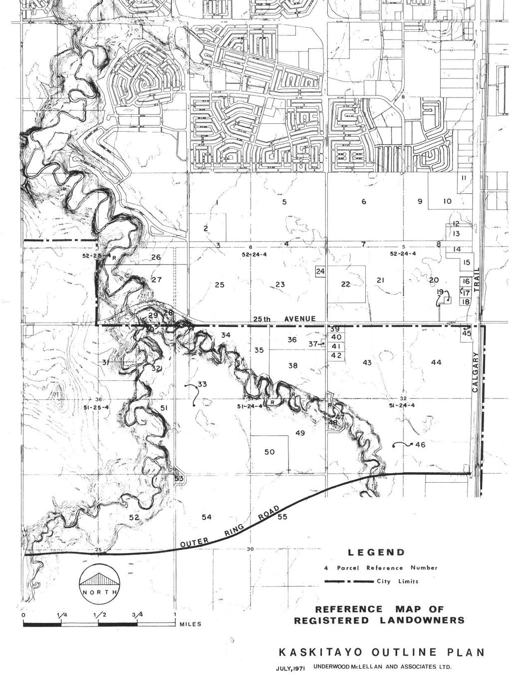
57 51
Central and East Neighbourhoods - Hermitage Outline Plan
 Central and East Neighbourhoods - Hermitage Outline Plan Office Consolidation September 2013 Prepared by: Planning and Policy Services Branch Planning and Development Department City of Edmonton The Central
CONTENTS 8.0 LAND USE 8.1 GENERAL LAND USE 8.2 RESIDENTIAL 8.3 MIXED USE 8.4 COMMERCIAL 8.5 EMPLOYMENT LANDS
 8-2 Land Use 8.0 LAND USE CONTENTS 8.1 GENERAL LAND USE 8.1.1 Uses provided for in all Land Use Designations 8.1.2 Uses prohibited in Hazardous Lands, Hazardous Sites and Special Policy Areas 8.1.3 Uses
City of Grande Prairie Development Services Department
 City of Grande Prairie Development Services Department ROYAL OAKS NORTH OUTLINE PLAN OP-07-03 NW 35-71-6 W6M May 7, 2007 Royal Oaks North Outline Plan TABLE OF CONTENTS 1.0 INTRODUCTION........ 3 1.1 Purpose
LAND USE AMENDMENT CORNERSTONE (WARD 3) 60 STREET NE AND COUNTRY HILLS BOULEVARD NE MAP 26NE BYLAW 22D2017
 60 STREET NE AND COUNTRY HILLS BOULEVARD NE MAP 26NE BYLAW 22D2017") Page 1 of 14 EXECUTIVE SUMMARY This Land Use Amendment application covers an area of 43.76 hectares ± (108.14 acres ±) located in northeast Calgary, bound by Country Hills Boulevard NE to the south and
Page 1 of 14 EXECUTIVE SUMMARY This Land Use Amendment application covers an area of 43.76 hectares ± (108.14 acres ±) located in northeast Calgary, bound by Country Hills Boulevard NE to the south and
City of Grande Prairie Development Services Department KENNEDY DEVELOPMENTS LTD. OUTLINE PLAN OP-09-01
 City of Grande Prairie Development Services Department KENNEDY DEVELOPMENTS LTD. OUTLINE PLAN OP-09-01 July 27, 2009 TABLE OF CONTENTS 1.0 Introduction... 1 1.1 Plan Area Location & Context... 1 1.2 Ownership
URBAN DESIGN BRIEF. 2136&2148 Trafalgar Road. Town of Oakville
 URBAN DESIGN BRIEF 2136&2148 Trafalgar Road Town of Oakville Prepared By: METROPOLITAN CONSULTING INC For 2500674 Ontario Inc November 2016 TABLE OF CONTENTS Page No. 1.0 Introduction/Description of Subject
OP Council Resolution June 16, Planning and Development Services
 OP-08-01 Council Resolution June 16, 2008 Planning and Development Services Kingsgate Landing Outline Plan Table of Contents 1.0 Introduction 1 1.1 Purpose of Plan 1 1.2 Plan Area Location 1 1.3 Ownership
OFFICE CONSOLIDATION SECONDARY PLAN AREA 22 THE BRAMALEA SOUTH INDUSTRIAL SECONDARY PLAN
 OFFICE CONSOLIDATION SECONDARY PLAN AREA 22 THE BRAMALEA SOUTH INDUSTRIAL SECONDARY PLAN November 2010 EXPLANATORY NOTES (Secondary Plan Area 22) General (pertaining to all secondary plan office consolidations)
S o u t h C e n t r a l O u t l i n e P l a n. Leduc Business Park. North Leduc Industrial Area Structure Plan C it y of Led u c.
 Leduc Business Park North Leduc Industrial Area Structure Plan C it y of Led u c Prepared for Farm Air Properties Inc. January, 2007 Table of Contents Page Number 1.0 Purpose of Plan and Definition of
[PLANNING RATIONALE] For Site Plan Control and Lifting of Holding Zone By-Law 101 Champagne Avenue. May 23, 2014
![[PLANNING RATIONALE] For Site Plan Control and Lifting of Holding Zone By-Law 101 Champagne Avenue. May 23, 2014](/thumbs/75/71599615.jpg "[PLANNING RATIONALE] For Site Plan Control and Lifting of Holding Zone By-Law 101 Champagne Avenue. May 23, 2014") [PLANNING RATIONALE] For Site Plan Control and Lifting of Holding Zone By-Law 101 Champagne Avenue May 23, 2014 Contents 1.0 Introduction... 2 2.0 Site Context... 2 2.1 Adjacent Uses... 2 Figure 1: Site
[PLANNING RATIONALE] For Site Plan Control and Lifting of Holding Zone By-Law 101 Champagne Avenue May 23, 2014 Contents 1.0 Introduction... 2 2.0 Site Context... 2 2.1 Adjacent Uses... 2 Figure 1: Site
Chappelle Neighbourhood Area Structure Plan
 Chappelle Neighbourhood Area Structure Plan Office Consolidation September 2017 Prepared by: City Planning Urban Form and Corporate Strategic Development City of Edmonton Bylaw 14779 was adopted by Council
Clairtrell Area Context Plan
 Clairtrell Area Context Plan March 2005 Urban Development Services City Planning Contents 1. Introduction... 4 2. Development Structure... 6 2.1 Streets... 7 2.1.1 Sheppard Avenue and Bayview Avenue...
Regency Developments. Urban Design Brief. Holyrood DC2 Rezoning
 Regency Developments Urban Design Brief Holyrood DC2 Rezoning Stantec Consulting Ltd. 7-31-2017 1. Overview Regency Developments intends to rezone the lands located at 8510 and 8511 93 Avenue, within the
Mayliewan Neighbourhood Structure Plan Neighbourhood 7 of the Edmonton North Area Structure Plan
 Mayliewan Neighbourhood Structure Plan Neighbourhood 7 of the Edmonton North Area Structure Plan Office Consolidation November 2008 Prepared by: Planning and Policy Services Branch Planning and Development
Westwind Developments Ltd. PIONEER LANDS AREA STRUCTURE PLAN - PROPOSED AMENDMENT
 FEBRUARY 2013 TABLE OF CONTENTS 1.0 BACKGROUND... 1 1.1 Amendment... 1 2.0 LOCATION & CONTEXT... 2 2.1 Land Ownership... 2 3.0 POLICY CONTEXT... 3 3.1 Municipal Development Plan... 3 3.2 Capital Region
13 THORNHILL YONGE STREET STUDY IMPLEMENTATION CITY OF VAUGHAN OPA 669 AND TOWN OF MARKHAM OPA 154
 13 THORNHILL YONGE STREET STUDY IMPLEMENTATION CITY OF VAUGHAN OPA 669 AND TOWN OF MARKHAM OPA 154 The Planning and Economic Development Committee recommends the adoption of the recommendations contained
Urban Design Brief December 23, 2015 Southside Construction Group Official Plan & Zoning By-Law Amendment
 Urban Design Brief Proposed Official Plan & Zoning By-Law Amendment 3244, 3263 and 3274 Wonderland Road South Southside Group December 23, 2015 TABLE OF CONTENTS Page No. INTRODUCTION... 1 SECTION 1 LAND
ROAD CLOSURE AND LAND USE AMENDMENT SILVER SPRINGS (WARD 1) NORTHEAST OF NOSEHILL DRIVE NW AND SILVER SPRINGS ROAD NW BYLAWS 2C2018 AND 29D2018
 NORTHEAST OF NOSEHILL DRIVE NW AND SILVER SPRINGS ROAD NW BYLAWS 2C2018 AND 29D2018") Page 1 of 19 EXECUTIVE SUMMARY This application proposes redesignating two parcels in the community of Silver Springs from Special Purpose Future Urban Development (S-FUD) District and undesignated road
Page 1 of 19 EXECUTIVE SUMMARY This application proposes redesignating two parcels in the community of Silver Springs from Special Purpose Future Urban Development (S-FUD) District and undesignated road
Land Use Amendment in Southwood (Ward 11) at and Elbow Drive SW, LOC
 at and Elbow Drive SW, LOC") 2018 November 15 Page 1 of 10 EXECUTIVE SUMMARY This land use amendment application was submitted by Rick Balbi Architect on 2017 August 31 on behalf of Sable Developments Ltd, and with authorization from
2018 November 15 Page 1 of 10 EXECUTIVE SUMMARY This land use amendment application was submitted by Rick Balbi Architect on 2017 August 31 on behalf of Sable Developments Ltd, and with authorization from
ADMINISTRATION RECOMMENDATION 2016 November 03. That Calgary Planning Commission recommends APPROVAL of the proposed Land Use Amendment.
 Page 1 of 12 EXECUTIVE SUMMARY This Land Use Amendment application covers an area of 75.76 hectares ± (187.20 acres ±) located in northeast Calgary, bound by Stoney Trail NE to the north, 128 Avenue NE
Urban Design Brief. Watson Parkway North & Watson Road North Guelph, Ontario. Prepared by Coletara Development
 Urban Design Brief Watson Parkway North & Watson Road North Guelph, Ontario Prepared by Coletara Development December, 2013 Urban Design Brief, Coletara Development 1 Introduction This Urban Design Brief
Bylaw C-1186 Adopted November 5, Planning and Development Services
 Bylaw C-1186 Adopted November 5, 2007 Planning and Development Services CITY OF GRANDE PRAIRIE OFFICE CONSOLIDATION BYLAW C-1186 A Bylaw to adopt the Westgate Area Structure Plan (As Amended by Bylaw C-1186-1,
YONGE STEELES CORRIDOR SECONDARY PLAN. Young + Wright / IBI Group Architects Dillon Consulting Ltd. GHK International (Canada) Ltd.
 Ltd.") PART A: PREAMBLE 1.0 PURPOSE The purpose of this Secondary Plan is to provide a development framework for intensification of the Yonge/ Steeles corridor including the north side of Steeles Avenue West
PART A: PREAMBLE 1.0 PURPOSE The purpose of this Secondary Plan is to provide a development framework for intensification of the Yonge/ Steeles corridor including the north side of Steeles Avenue West
C ity of Grande Prairie Development Services Department
 C ity of Grande Prairie Development Services Department FAIRWAY DEVELOPMENT OUTLINE PLAN OP 08 09 Approved April 6, 2009 Prepared by: Focus Corporation Table of Contents 1.0. Introduction 2 3 1.1. Plan
LAND USE AMENDMENT CORNERSTONE (WARD 3) COUNTRY HILLS BOULEVARD AND STONEY TRAIL NE BYLAW 9D2017
 COUNTRY HILLS BOULEVARD AND STONEY TRAIL NE BYLAW 9D2017") Page 1 of 12 EXECUTIVE SUMMARY This Land Use Amendment application covers an area of 54.92 hectares ± (135.71 acres ±) located in northeast Calgary, bound by Country Hills Boulevard NE to the north and
Page 1 of 12 EXECUTIVE SUMMARY This Land Use Amendment application covers an area of 54.92 hectares ± (135.71 acres ±) located in northeast Calgary, bound by Country Hills Boulevard NE to the north and
TO: Mayor & Council DATE: April 12, The Planning and Development Department and the Engineering Department recommend that Council:
 CORPORATE REPORT NO: R080 COUNCIL DATE: April 12, 2010 REGULAR COUNCIL TO: Mayor & Council DATE: April 12, 2010 FROM: SUBJECT: General Manager, Planning and Development General Manager, Engineering Neighbourhood
Yellowhead Corridor Area Structure Plan
 Yellowhead Corridor Area Structure Plan Office Consolidation June 2014 Prepared by: Current Planning Branch Sustainable Development City of Edmonton Bylaw 7044, as amended, was adopted by Council in April
Further input invited as Colchester Growth Strategy nears final phase
 IUE 3 / NOVEMBER 2015 Further input invited as Colchester Growth trategy nears final phase trathcona County is seeking public feedback as it enters the final phase of work on a Growth Management trategy
Outline Plan in Belvedere (Ward 9) at Street SE, LOC (OP)
 at Street SE, LOC (OP)") 2018 October 04 Page 1 of 12 EXECUTIVE SUMMARY This outline plan application was submitted by B&A Planning Group on 2016 July 15, on behalf of Tristar Communities Inc. for 50.14 hectares (123.89 acres)
2018 October 04 Page 1 of 12 EXECUTIVE SUMMARY This outline plan application was submitted by B&A Planning Group on 2016 July 15, on behalf of Tristar Communities Inc. for 50.14 hectares (123.89 acres)
178 Carruthers Properties Inc.
 178 Carruthers Properties Inc. Planning Rationale for 178 Carruthers Avenue Site Plan Control Application June 2014 Table of Contents 1.0 Introduction 2.0 Overview of Subject Property 3.0 Current Zoning
Ten Mile Creek Planning Area
 PLANNING AREA POLICIES TEN MILE CREEK Ten Mile Creek Planning Area Location and Context The Ten Mile Creek Planning Area ( Ten Mile Creek area ) is located south of the current Boise AOCI, generally south
North Oakville East Parks Facilities Distribution Plan. November, 2009
 North Oakville East November, 2009 POLICY CONTEXT 1) Purpose a) The purpose of this document is to be a guide for the location, configuration, design and development of the parks system for the North Oakville
Ebbers Neighbourhood Area Structure Plan
 Ebbers Neighbourhood Area Structure Plan Office Consolidation November 2016 Prepared by: City Planning Branch Sustainable Development City of Edmonton Bylaw 14079, was adopted by Council in February 2006.
Bylaw C-1262 Adopted February 6, Planning and Development Department
 Bylaw C-1262 Adopted February 6, 2012 Planning and Development Department CITY OF GRANDE PRAIRIE BYLAW C-1262 A Bylaw to adopt the Brookfield Neighbourhood Outline Plan THE MUNICIPAL COUNCIL OF THE CITY
AGINCOURT SECONDARY PLAN
 1 AGINCOURT SECONDARY PLAN 1. AGINCOURT SECONDARY PLAN The following policies and principles apply to the area herein referred to as Agincourt, as outlined on Map 1-1. 1. GENERAL POLICIES 1.1 This Secondary
Mark-up of the effect of the proposed Bronte Village Growth Area OPA No.18 on the text of section 24, Bronte Village, of the Livable Oakville Plan
 Mark-up of the effect of the proposed Bronte Village Growth Area OPA No.18 on the text of section 24, Bronte Village, of the Livable Oakville Plan Notes: This document is provided for information purposes
5.1 Site Plan Guidelines
 5. Community Core Guidelines Development of the Community Core will take place by plan of subdivision and site plan approval. It will occur in a phased manner that will reflect the timing of residential
Description of Preferred Alternative
 Chapter 2 Description of Preferred Alternative 2.1 Introduction This chapter of the programmatic Sammamish Town Center Sub-area Plan Final EIS provides a more detailed description of the Preferred Alternative
QUEEN-RIVER SECONDARY PLAN
 34 QUEEN-RIVER SECONDARY PLAN 34. QUEEN RIVER SECONDARY PLAN 1. INTRODUCTION The Queen-River area is approximately 6.4 hectares and is located at the eastern edge of the Downtown as shown on Map 34-1.
URBAN DESIGN BRIEF URBAN DESIGN BRIEF 721 FRANKLIN BLVD, CAMBRIDGE August 2018
 URBAN DESIGN BRIEF URBAN DESIGN BRIEF 721 FRANKLIN BLVD, CAMBRIDGE August 2018 DESIGN BRIEF CONTENTS PART A 1.0 INTRODUCTION 2.0 DESCRIPTION & ANALYSIS OF SITE CONTEXT 3.0 DESIGN CONSTRAINTS AND OPPORTUNITIES
GUIDELINES. Transit Oriented Development. Approved by Edmonton City Council on February 15, 2012 in tandem with City Policy C565
 Transit Oriented Development GUIDELINES Prepared by the City of Edmonton Sustainable Development and Transportation Services Departments Approved by Edmonton City Council on February 15, 2012 in tandem
Bylaw No. B-03/2011 Adopted by Airdrie City Council February 21, 2012
 COOPER S CROSSING STAGE 4 Neighbourhood Structure Plan City of Airdrie WESTMARK HOLDINGS LTD. Bylaw No. B-03/2011 Adopted by Airdrie City Council February 21, 2012 CONSULTANTS: LAND USE PLANNING: Southwell
Red Fox Commercial Outline Plan
 Red Fox Commercial Outline Plan City of Cold Lake, Alberta Prepared by Durrance Projects Ltd and Ross W. Sharp & Associates Ltd October 2014 Rupert 1 Table of Contents 1. PURPOSE...3 1.1. Location...4
DRAFT Northeast Quadrant of Kipling Avenue and Highway 7 DRAFT AUGUST 29, Goals Land Use. The goals of this Plan are to:
 AUGUST 29, 2017 12.15 Northeast Quadrant of Kipling Avenue and Highway 7 12.15.1 Goals 12.15.2 Land Use The goals of this Plan are to: 12.15.2.1 General Provisions: a) Ensure the development of a compact
1.4 TRANSIT VISION 2040 FROM VISION TO ACTION THEME 1: PUTTING TRANSIT AT THE CENTRE OF COMMUNITIES. Fully integrate transit with community design
 TRANSIT VISION 2040 FROM VISION TO ACTION TRANSIT VISION 2040 defines a future in which public transit maximizes its contribution to quality of life with benefits that support a vibrant and equitable society,
LAND USE AMENDMENT DOWNTOWN COMMERCIAL CORE (WARD 7) MACLEOD TRAIL SE AND 5 AVENUE SE BYLAW 254D2017
 MACLEOD TRAIL SE AND 5 AVENUE SE BYLAW 254D2017") Page 1 of 10 EXECUTIVE SUMMARY This Land Use Amendment application seeks to redesignate a full downtown block (currently the YWCA site) from a Direct Control based on the CM-2 District (Land Use Bylaw
Page 1 of 10 EXECUTIVE SUMMARY This Land Use Amendment application seeks to redesignate a full downtown block (currently the YWCA site) from a Direct Control based on the CM-2 District (Land Use Bylaw
PORT WHITBY COMMUNITY
 PORT WHITBY COMMUNITY SECONDARY PLAN UPDATE COMMUNITY IMPROVEMENT PLAN URBAN DESIGN GUIDELINES September 2015 DRAFT PROPOSED AMENDMENT NUMBER # to the Whitby Official Plan PURPOSE: The intent of this Amendment
6. REGIONAL AND COMMUNITY FACILITIES DESIGNATIONS 6.1. OBJECTIVES FOR REGIONAL AND COMMUNITY FACILITIES LAND USE DESIGNATIONS
 6. REGIONAL AND COMMUNITY FACILITIES DESIGNATIONS INTRODUCTION The Regional and land use designations provide the primary locations for uses which satisfy the health, education and other service needs
Planning Districts INTRODUCTION
 INTRODUCTION To facilitate detailed examination of development prospects for all areas of the community, Delano has been divided into 14 planning districts. The location of these planning districts is
ELMVALE ACRES SHOPPING CENTRE MASTER PLAN
 ELMVALE ACRES SHOPPING CENTRE MASTER PLAN Contents 1.0 INTRODUCTION... 2 2.0 LOCATION... 2 3.0 EXISTING CONTEXT... 2 4.0 VISION & GUIDING PRINCIPLES... 2 5.0 LAND USE AND BUILT FORM... 4 5.1 St. Laurent
and services The protection and conservation of environmentally significant and sensitive natural heritage features and functions.
 6. Land Use 6.0 Preamble A healthy and livable city is one in which people can enjoy a vibrant economy and a sustainable healthy environment in safe, caring and diverse neighbourhoods. In order to ensure
Town of Portola Valley General Plan. Nathhorst Triangle Area Plan
 Town of Portola Valley General Plan Amended December 10, 1997 Table of Contents Introduction... 1 Planning Area... 1 Objectives... 2 Principles... 2 Standards... 4 Description... 4 Community Commercial...
Mill Woods Town Centre Proposed Rezoning LDA
 Mill Woods Town Centre Proposed Rezoning LDA15 0649 The City of Edmonton has received an application for rezoning and an amendment to the Mill Woods Station Area Redevelopment Plan (ARP) for the Mill Woods
General Location Annex, Rezone & Preliminary Plat Lansdowne Addition, Unit Three
 NEWFOUNDLAND I-5 Agricultural District Subject Site SUNDANCE ANDERSON Single Family Residential CHRISTY PUD Agricultural District Highway Business General Location Annex, Rezone & Preliminary Plat Lansdowne
Terra Losa Neighbourhood Structure Plan
 Terra Losa Neighbourhood Structure Plan Office Consolidation May 2006 Prepared by: Planning and Policy Services Branch Planning and Development Department City of Edmonton Bylaw 6616 was adopted by Council
Bressa Developments Limited. Planning Justification Report. Revised Draft Plan of Subdivision and Zoning By-Law Amendment
 Bressa Developments Limited Revised Draft Plan of Subdivision and Zoning By-Law Amendment Planning Justification Report Part of Lots 7 & 8 Concession 1, North of Dundas Street Town of Oakville September,
Section 9 NEIGHBORHOOD DESIGN
 Section 9 NEIGHBORHOOD DESIGN City of Lancaster Comprehensive Plan D u n k i n, S e f k o & A s s o c i a t e s, I n c. NEIGHBORHOOD DESIGN INTRODUCTION There are many ways in which a neighborhood can
Bulyea Heights Neighbourhood Structure Plan
 Bulyea Heights Neighbourhood Structure Plan Office Consolidation April 2016 Prepared by: City Planning Branch Sustainable Development Department City of Edmonton Bylaw 8095 was adopted by Council in February
11.4 Highway 400 North Employment Lands Secondary Plan APPROVED BY THE ONTARIO MUNICIPAL BOARD ON NOVEMBER 21, 2011
 11.4 Highway 400 North Employment Lands Secondary Plan APPROVED BY THE ONTARIO MUNICIPAL BOARD ON NOVEMBER 21, 2011 11.4.1 General 11.4.1.1. as approved by the Ontario Municipal Board on November 21, 2011,
Terra Losa Neighbourhood Structure Plan
 Terra Losa Neighbourhood Structure Plan Office Consolidation January 22, 2018 Prepared by: City Planning Urban Form and Corporate Strategic Development City of Edmonton Bylaw 6616 was adopted by Council
This Review Is Divided Into Two Phases:
 Semiahmoo Town Centre Review The purpose of this review: To review the Semiahmoo Town Centre Concept Plan, originally approved in 1993, to ensure that this centre will continue to serve the needs of South
Gold Line Bus Rapid Transit Transit Oriented Development (BRTOD) Helmo Station Area Plan
 Helmo Station Area Plan") Appendix F Gold Line Bus Rapid Transit Transit Oriented Development (BRTOD) Helmo Station Area Plan Introduction and Purpose of the Plan The Gold Line Bus Rapid Transit facility is an eleven-mile dedicated
Appendix F Gold Line Bus Rapid Transit Transit Oriented Development (BRTOD) Helmo Station Area Plan Introduction and Purpose of the Plan The Gold Line Bus Rapid Transit facility is an eleven-mile dedicated
POLICY AMENDMENT AND LAND USE AMENDMENT KILLARNEY/GLENGARRY (WARD 8) NW CORNER OF RICHMOND ROAD AND 33 STREET SW BYLAWS 1P2015 AND 7D2015
 NW CORNER OF RICHMOND ROAD AND 33 STREET SW BYLAWS 1P2015 AND 7D2015") Page 1 of 13 EXECUTIVE SUMMARY This application seeks to redesignate an RC-2 (Residential Contextual One/Two Dwelling) parcel to MC-Gd72 (Multi-Residential Contextual Grade-Oriented) to allow for multi-residential
Page 1 of 13 EXECUTIVE SUMMARY This application seeks to redesignate an RC-2 (Residential Contextual One/Two Dwelling) parcel to MC-Gd72 (Multi-Residential Contextual Grade-Oriented) to allow for multi-residential
FORMER CANADIAN FORCES BASE (CFB) ROCKCLIFFE SECONDARY PLAN. Official Plan Amendment XX to the Official Plan for the City of Ottawa
 ROCKCLIFFE SECONDARY PLAN. Official Plan Amendment XX to the Official Plan for the City of Ottawa") FORMER CANADIAN FORCES BASE (CFB) ROCKCLIFFE SECONDARY PLAN Official Plan Amendment XX to the Official Plan for the City of Ottawa 1 INDEX THE STATEMENT OF COMPONENTS PART A THE PREAMBLE PAGE Purpose...
FORMER CANADIAN FORCES BASE (CFB) ROCKCLIFFE SECONDARY PLAN Official Plan Amendment XX to the Official Plan for the City of Ottawa 1 INDEX THE STATEMENT OF COMPONENTS PART A THE PREAMBLE PAGE Purpose...
Canossa NSP. Office Consolidation August Prepared by: Planning and Policy Services Branch Planning and Development Department City of Edmonton
 Canossa NSP Office Consolidation August 2004 Prepared by: Planning and Policy Services Branch Planning and Development Department City of Edmonton Bylaw 7613 (as amended) was adopted by Council October
5.0 VILLAGE AREAS. February 2008 Municipality of West Elgin ~ Official Plan 5-1
 5.0 VILLAGE AREAS This section of the Official Plan deals with the villages of Rodney and West Lorne being the two largest and only fully serviced settlement areas in West Elgin and the most logical and
6 Growth Management Challenges and Opportunities
 6 Growth Management Challenges and Opportunities The Town has established a goal of attaining a 50% participation rate with respect to employment opportunities versus residential population. The Town s
This application has been applied for with support of an Outline Plan to provide the technical details for the site s development.
 Page 1 of 13 EXECUTIVE SUMMARY This application consists of a Land Use Amendment application proposing redesignation from Special Purpose Future Urban Development (S-FUD) District to an assortment of multiresidential,
Oxford Neighbourhood Structure Plan
 Oxford Neighbourhood Structure Plan Office Consolidation November 2010 Prepared by: Planning and Policy Services Branch Planning and Development Department City of Edmonton Bylaw 7963, was adopted by Council
599 Kennedy Road - Official Plan Amendment and Zoning Amendment Application - Preliminary Report
 STAFF REPORT ACTION REQUIRED 599 Kennedy Road - Official Plan Amendment and Zoning Amendment Application - Preliminary Report Date: March 7, 2017 To: From: Wards: Reference Number: Scarborough Community
TABLE OF CONTENTS 1.0 INTRODUCTION... 3
 TABLE OF CONTENTS 1.0 INTRODUCTION... 3 1.1. BACKGROUND... 3 1.2. THE PROPOSAL... 5 2.0 EXISTING POLICY FRAMEWORK... 5 2.1. PROVINCIAL POLICY STATEMENT (PPS)... 5 2.2. CITY OF LONDON OFFICIAL PLAN (OP)...
12 AMENDMENT NO. 149, TOWN OF MARKHAM HIGHWAY 404 NORTH SECONDARY PLAN
 12 AMENDMENT NO. 149, TOWN OF MARKHAM HIGHWAY 404 NORTH SECONDARY PLAN The Planning and Economic Development Committee recommends the adoption of the recommendation contained in the following report August
ADMINISTRATION RECOMMENDATION(S) 2018 January 25. That Calgary Planning Commission recommend APPROVAL of the proposed Land Use Amendment.
 2018 January 25. That Calgary Planning Commission recommend APPROVAL of the proposed Land Use Amendment.") Page 1 of 9 EXECUTIVE SUMMARY This land use amendment proposes to redesignate a parcel from DC Direct Control District to Multi-Residential Contextual Grade-Oriented (M-CG) District to allow for multi-residential
Page 1 of 9 EXECUTIVE SUMMARY This land use amendment proposes to redesignate a parcel from DC Direct Control District to Multi-Residential Contextual Grade-Oriented (M-CG) District to allow for multi-residential
URBAN DESIGN BRIEF Gordon Street City of Guelph. Prepared on behalf of Ontario Inc. March 25, Project No. 1507
 URBAN DESIGN BRIEF 1131 Gordon Street City of Guelph Prepared on behalf of 1876698 Ontario Inc. March 25, 2016 Project No. 1507 423 Woolwich Street, Suite 201, Guelph, Ontario, N1H 3X3 Phone (519) 836-7526
Urban Design Brief Fanshawe Park Road. Competition Toyota
 Urban Design Brief 1300 Fanshawe Park Road Competition Toyota May 2, 2014 TABLE OF CONTENTS Page No. INTRODUCTION... 1 SECTION 1 LAND USE PLANNING CONTEXT... 1 1.1 The Subject Lands... 1 1.2 The Proposal...
Amendment to the Elderberry Neighborhood Development Plan
 Amendment to the Elderberry Neighborhood Development Plan Recommendations for Land Use, Transportation and Development July 13, 2018 City of Madison, Wisconsin Department of Planning and Community and
Complete Neighbourhood Guidelines Review Tool
 Complete Neighbourhood Guidelines Review Tool Prepared By: City of Regina Planning Department October 2014 Page 1 of 14 Community Development Review Checklist for Secondary Plans and Concept Plans The
UNIVERSITY OF MICHIGAN:
 Chapter Eight UNIVERSITY OF MICHIGAN: North Campus I. Introduction The University of Michigan currently owns approximately 800 acres of land in the northeast section of Ann Arbor. North Campus refers to
HURON COMMUNITY PLAN
 CITY OF KITCHENER DEPARTMENT OF DEVELOPMENT AND TECHNICAL SERVICES PD 94/7 HURON COMMUNITY PLAN Recommended by Planning and Economic Development Committee: October 31, 1994 Adopted by Kitchener City Council:
BROOKHILL NEIGHBORHOOD MODEL ZONING MAP AMENDMENT PREFACE TO APPLICATION
 BROOKHILL NEIGHBORHOOD MODEL ZONING MAP AMENDMENT PREFACE TO APPLICATION June 15, 2015 Revised: August 1, 2016 I. VISION Brookhill is a proposed community based upon the principles of Albemarle County
The transportation system in a community is an
 7 TRANSPORTATION The transportation system in a community is an important factor contributing to the quality of life of the residents. Without a sound transportation system to bring both goods and patrons
9 CITY OF VAUGHAN OFFICIAL PLAN AMENDMENT NO BOCA EAST INVESTMENTS LIMITED
 9 CITY OF VAUGHAN OFFICIAL PLAN AMENDMENT NO. 631 - BOCA EAST INVESTMENTS LIMITED The Planning and Economic Development Committee recommends the adoption of the recommendations contained in the following
THE CITY OF SPRUCE GROVE BYLAW C PIONEER LANDS AREA STRUCTURE PLAN AMENDMENT
 THE CITY OF SPRUCE GROVE BYLAW C-797-11 PIONEER LANDS AREA STRUCTURE PLAN AMENDMENT WHEREAS, pursuant to the Municipal Government Act, R.S.A., 2000, c.m-26, a municipality shall adopt Area Structure Plans
COLVER ROAD INDUSTRIAL CONCEPT PLAN
 COLVER ROAD INDUSTRIAL CONCEPT PLAN A CONCEPTUAL LAND USE AND TRANSPORTATION PLAN FOR TA-4 AN URBAN RESERVE AREA OF THE CITY TALENT City of Talent Adopted by City Council Resolution No., June, 2015 PART
PLANNING RATIONALE FOR THE PROPOSED RIVERSIDE SOUTH ELEMENTARY SCHOOL 715 BRIAN GOOD AVENUE, OTTAWA, ON
 PLANNING RATIONALE FOR THE PROPOSED RIVERSIDE SOUTH ELEMENTARY SCHOOL 715 BRIAN GOOD AVENUE, OTTAWA, ON Conseil des écoles publiques de l'est de l'ontario (CEPEO) French Public School Board TABLE OF CONTENTS
141 GEORGE STREET PLANNING RATIONALE
 141 GEORGE STREET PLANNING RATIONALE MINOR ZONING BY-LAW AMENDMENT NOVEMBER 2, 2016 PLANNING RATIONALE 223 McLeod Street Ottawa, ON K2P 0Z8 613.730.5709 fotenn.com INTRODUCTION FOTENN Consultants is acting
The West Vaughan Employment Area Secondary Plan Policies
 Part 2: The West Vaughan Employment Area Secondary Plan Policies 2.1 General Policies It is the policy of Council: 2.1.1. That the West Vaughan Employment Area (the WVEA), identified on Schedule 1, will
2136 & 2148 Trafalgar Road Town of Oakville Region of Halton
 PLANNING JUSTIFICATION REPORT 2136 & 2148 Trafalgar Road Town of Oakville Region of Halton Zoning By-Law Amendment Application 2500674 Ontario Inc. November 2016 Table of Contents Page 1.0 Location/Summary
ONTARIO MUNICIPAL BOARD
 PL 120483 ONTARIO MUNICIPAL BOARD Applicant/Appellant: 2124123 Ontario Limited Subject: OPA, Rezoning and Draft Plan of Subdivision Municipal Address: 3940 Highway 7 East Municipality: City of Markham
KANATA CENTRUM 255 KANATA AVENUE OFFICIAL PLAN AMENDMENT ZONING BY-LAW AMENDMENT
 KANATA CENTRUM 255 KANATA AVENUE OFFICIAL PLAN AMENDMENT ZONING BY-LAW AMENDMENT JUNE 2015 PREPARED BY: FOTENN Consultants Inc. 223 Mcleod Street Ottawa, ON K2P OZ8 (613) 730-5709 PREPARED FOR: Kanata
SPECIFIC PLAN Requirements
 CITY OF LANCASTER PLANNING DEPARTMENT 44933 Fern Avenue, Lancaster, California 93534 (661) 723-6100 SPECIFIC PLAN Requirements Purpose The purpose of a specific plan is to provide for the logical development
4780 Eglinton Avenue West - Zoning By-law Amendment and Draft Plan of Subdivision Applications - Preliminary Report
 STAFF REPORT ACTION REQUIRED 4780 Eglinton Avenue West - Zoning By-law Amendment and Draft Plan of Subdivision Applications - Preliminary Report Date: May 29, 2014 To: From: Wards: Reference Number: Etobicoke
11.4 Highway 400 North Employment Lands Secondary Plan
 11.4 Highway 400 North Employment Lands Secondary Plan APPROVED BY THE ONTARIO MUNICIPAL BOARD ON NOVEMBER 21, 2011 11.4.1 General 11.4.1.1. The following policies and Schedules A - I form Official Plan
6 PORT SYDNEY SETTLEMENT AREA
 Section 6 Port Sydney Page 61 6 PORT SYDNEY SETTLEMENT AREA 6.1 Basis and Principles Village of Port Sydney Waterfront Community Existing Services 6.1.1 Port Sydney is an historic settlement that has developed
I539. Smales 2 Precinct
 I539. Smales 2 Precinct I539.1. Precinct Description The Smales 2 Precinct applies to a 4.8 hectare block of land located on the southern side of Northcote Road and fronting Lake Pupuke, Takapuna. The
3 TOWN OF WHITCHURCH-STOUFFVILLE OFFICIAL PLAN AMENDMENT NOS. 116 & 117
 3 TOWN OF WHITCHURCH-STOUFFVILLE OFFICIAL PLAN AMENDMENT NOS. 116 & 117 The Planning and Economic Development Committee recommends the adoption of the recommendations contained in the following report,
Northern Territory Compact Urban Growth Policy
 Northern Territory Compact Urban Growth Policy A Reference Policy Document to clause 2.7 (Reference to Policy) of the NT Planning Scheme May 2015 Table of Contents 1 Policy Setting... 3 1.1 Context for
Mitchell Ranch South MPUD Application for Master Planned Unit Development Approval Project Narrative. Introduction
 Mitchell Ranch South MPUD Application for Master Planned Unit Development Approval Project Narrative Introduction Mitchell Ranch South is a proposed single family (detached) residential development on
6.0 Land Use Policies for Rural Settlements. 6.1 Rural Settlement Strategy
 6.0 Land Use Policies for Rural Settlements 6.1 Rural Settlement Strategy INTRODUCTION AMENDMENT NO. 131 PURPOSE Designated rural settlements comprise Rural Clusters, Villages and Serviced Villages as
Official Plan Review: Draft Built Form Policies
 PG.30.1 REPORT FOR ACTION Official Plan Review: Draft Built Form Policies Date: May 15, 2018 To: Planning and Growth Management Committee From: Chief Planner and Executive Director, City Planning Division