ROSE SENIOR LIVING AT PROVIDENCE JSP13-81
|
|
|
- Tamsyn Murphy
- 5 years ago
- Views:
Transcription
 Overlay Development Agreement Application and Concept Plan. The subject property is 23.")
1 ROSE SENIOR LIVING AT PROVIDENCE JSP13-81 Rose Senior Living at Providence JSP13-81 Public hearing at the request of Edward Rose and Sons for recommendation to City Council for approval of a Planned Suburban Low-Rise (PSLR) Overlay Development Agreement Application and Concept Plan. The subject property is acres in Section 17 of the City of Novi and located on the north side of Eleven Mile Road and west of Beck Road. The applicant is proposing a 182 unit senior living facility. Required Action Recommend approval/denial of the Planned Suburban Low-Rise (PSLR) Overlay Concept Plan to the City Council. REVIEW RESULT DATE COMMENTS Planning Engineering Traffic Landscaping Approval recommended Approval recommended Approval recommended Approval recommended City Council deviations to allow front yard parking (southern yard) and a minimum berm height of 2 ft. (min. 3 ft. required) requested Staff supported City Council deviation to allow a proposed building length of 467 ft. (max. bldg. length 360 ft. permitted) Staff supported City Council deviation to allow a maximum bldg. height of 41 ft. (max. height 35 ft. permitted) Staff supported City Council deviation to allow carports in the interior side yard Staff supported City Council deviation to allow a business sign and entranceway sign Staff does not object City Council deviation to allow an access drive on a section line road Staff does not object Items to be addressed on the Preliminary Site Plan submittal City Council deviation to allow construction of a stormwater detention basin over existing sanitary sewer easement Staff does not support Items to be addressed on the Preliminary Site Plan submittal Items to be addressed on the Preliminary Site Plan submittal City Council deviations to allow a 2 ft. berm for parking lot screening (3 ft. required), to allow a1.5 ft. to 5 ft. wall in lieu of the required berm and for the lack of a 4 ft.
2 Wetland Woodland Façade Fire Approval recommended Approval recommended Approval recommended Approval recommended wide landscape bed around the entire building foundation Staff supported Items to be addressed on the Preliminary Site Plan submittal MDEQ Permit, City Wetland Non-Minor Use Permit and Authorization to Encroach into the 25 Ft. Natural Features Setback required Items to be addressed on the Preliminary Site Plan submittal City Woodland Permit required Items to be addressed on the Preliminary Site Plan submittal City Council deviations to allow pedestrian entrances more than 60 ft. apart and an overage of asphalt shingles Staff supported Items to be addressed on the Preliminary Site Plan submittal Items to be addressed on the Preliminary Site Plan submittal
3 Motion Sheet Approval PSLR Overlay Concept Plan In the matter of Rose Senior Living at Providence, JSP13-81, motion to recommend approval of the Planned Suburban Low-Rise (PSLR) Overlay Development Agreement Application and Concept Plan based on the following findings, City Council deviations, and conditions: a. The PSLR Overlay Development Agreement and PSLR Overlay Concept Plan will result in a recognizable and substantial benefit to the ultimate users of the project and to the community (as noted in the planning review letter); b. In relation to the underlying zoning or the potential uses contemplated in the City of Novi Master Plan, the proposed type and density of the use will not result in an unreasonable increase in the use of public services, facilities and utilities, and will not place an unreasonable burden upon the subject property, surrounding land, nearby property owners and occupants, or the natural environment (as indicated in the applicant s Community Impact Statement and the wetland and woodland review letters); c. In relation to the underlying zoning or the potential uses contemplated in the City of Novi Master Plan, the proposed development will not cause a negative impact upon surrounding properties (as the proposed building has been substantially buffered by existing and created natural features and should minimally impact the surrounding properties); d. The proposed development will be consistent with the goals and objectives of the City of Novi Master Plan, and will be consistent with the requirements of Article 23B (as the proposed development meets the stated intent of the PSLR Overlay District to encourage transitional uses between higher intensity office and retail uses and lower intensity residential uses while maintaining the residential character of the area as outlined in the planning review letter); e. City Council deviations for the following (as the Concept Plan provides substitute safeguards for each of the regulations and there are specific, identified features or planning mechanisms deemed beneficial to the City by the City Council which are designed into the project for the purpose of achieving the objectives for the District as stated in the planning review letter): 1. City Council deviations to allow front yard parking (southern yard) and a minimum berm height of 2 ft. (min. 3 ft. required); 2. City Council deviation to allow a proposed building length of 467 ft. (max. bldg. length 360 ft. permitted); 3. City Council deviation to allow a maximum bldg. height of 41 ft. (max. height 35 ft. permitted); 4. City Council deviation to allow carports in the interior side yard; 5. City Council deviation to allow a business sign and entranceway sign; 6. City Council deviation to allow an access drive on a section line road; 7. City Council deviations to allow a 2 ft. berm for parking lot screening (3 ft. required), to allow a1.5 ft. to 5 ft. wall in lieu of the required berm and for the lack of a 4 ft. wide landscape bed around the entire building foundation; and 8. City Council deviations to allow pedestrian entrances more than 60 ft. apart and an overage of asphalt shingles; f. The applicant revising the plan to relocate the proposed stormwater detention basin so that it does not cover the existing sanitary sewer easement or relocate the sanitary sewer accordingly;
4 g. The findings of compliance with Ordinance standards in the staff and consultant review letters and the conditions and the items listed in those letters being addressed on the Preliminary Site Plan; and h. (additional comments here if any) (because the plan is otherwise in compliance with Article 23B, Article 24 and Article 25 of the Zoning Ordinance and all other applicable provisions of the Ordinance.) -OR- Denial PSLR Overlay Concept Plan In the matter of Rose Senior Living at Providence, JSP13-81, motion to recommend denial of the Planned Suburban Low-Rise (PSLR) Overlay Development Agreement Application and Concept Plan (because the proposed concept plan would not satisfy the findings and conditions noted in Article 23B of the Zoning Ordinance.)
5 Maps Location Zoning Future Land Use Natural Features
6 Rose Senior Living at Providence JSP13-81 Location Map Legend Subject Property Providence Ring Road Subject Property Feet inch = 318 feet I Beck Road Map Author: Kristen Kapelanski Date: Project: Rose Senior Living JSP13-81 Version #: 1.0 City of Novi Planning Division Community Development Dept W Ten Mile Rd Novi, MI cityofnovi.org Eleven Mile Road MAP INTERPRETATION NOTICE Map information depicted is not intended to replace or substitute for any official or primary source. This map was intended to meet National Map Accuracy Standards and use the most recent, accurate sources available to the people of the City of Novi. Boundary measurements and area calculations are approximate and should not be construed as survey measurements performed by a licensed Michigan Surveyor as defined in Michigan Public Act 132 of 1970 as amended. Please contact the City GIS Manager to confirm source and accuracy information related to this map.
7 Rose Senior Living at Providence JSP13-81 Zoning Providence Ring Road Map Legend Subject Property PSLR Overlay R-A: Residential Acreage R-3: One-Family Residential District R-4: One-Family Residential District RM-1: Low-Density Multiple Family RM-2: High-Density Multiple Family OSC: Office Service Commercial Subject Property Feet inch = 318 feet I Beck Road Map Author: Kristen Kapelanski Date: Project: Rose Senior Living JSP13-81 Version #: 1.0 City of Novi Planning Division Community Development Dept W Ten Mile Rd Novi, MI cityofnovi.org Eleven Mile Road MAP INTERPRETATION NOTICE Map information depicted is not intended to replace or substitute for any official or primary source. This map was intended to meet National Map Accuracy Standards and use the most recent, accurate sources available to the people of the City of Novi. Boundary measurements and area calculations are approximate and should not be construed as survey measurements performed by a licensed Michigan Surveyor as defined in Michigan Public Act 132 of 1970 as amended. Please contact the City GIS Manager to confirm source and accuracy information related to this map.
8 Rose Senior Living at Providence JSP13-81 Future Land Use Providence Ring Road Map Legend Subject Property Single Family Multiple Family PSLR Office Commercial Educational Subject Property Feet inch = 318 feet I Beck Road Map Author: Kristen Kapelanski Date: Project: Rose Senior Living JSP13-81 Version #: 1.0 City of Novi Planning Division Community Development Dept W Ten Mile Rd Novi, MI cityofnovi.org Eleven Mile Road MAP INTERPRETATION NOTICE Map information depicted is not intended to replace or substitute for any official or primary source. This map was intended to meet National Map Accuracy Standards and use the most recent, accurate sources available to the people of the City of Novi. Boundary measurements and area calculations are approximate and should not be construed as survey measurements performed by a licensed Michigan Surveyor as defined in Michigan Public Act 132 of 1970 as amended. Please contact the City GIS Manager to confirm source and accuracy information related to this map.
9 Rose Senior Living at Providence JSP13-81 Natural Features Providence Ring Road Map Legend Subject Property Wetlands Woodlands Subject Property Feet inch = 318 feet I Beck Road Map Author: Kristen Kapelanski Date: Project: Rose Senior Living JSP13-81 Version #: 1.0 City of Novi Planning Division Community Development Dept W Ten Mile Rd Novi, MI cityofnovi.org Eleven Mile Road MAP INTERPRETATION NOTICE Map information depicted is not intended to replace or substitute for any official or primary source. This map was intended to meet National Map Accuracy Standards and use the most recent, accurate sources available to the people of the City of Novi. Boundary measurements and area calculations are approximate and should not be construed as survey measurements performed by a licensed Michigan Surveyor as defined in Michigan Public Act 132 of 1970 as amended. Please contact the City GIS Manager to confirm source and accuracy information related to this map.
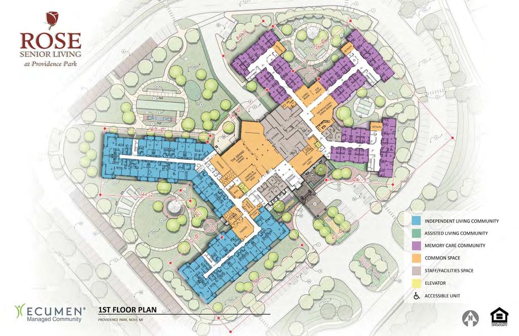
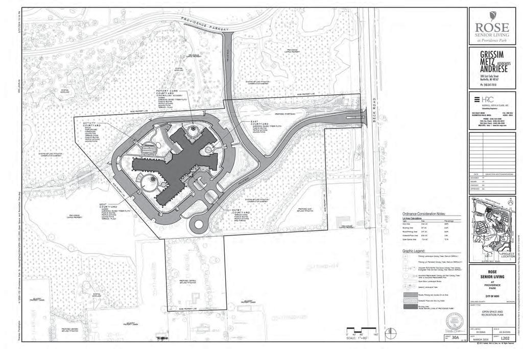
10 PSLR Overlay Concept Plan (Full plan set available for viewing at the Community Development Department.)
11

12

13
14 Planning Review
 Site Zoning: R-3 with PSLR Overlay Adjoining Zoning: North: R-3, One-Family Residential; East (across Beck Road): RM-2,")
15 Petitioner Edward Rose and Sons Review Type PSLR Concept Plan PLAN REVIEW CENTER REPORT March 11, 2014 Planning Review Rose Senior Living at Providence JSP13-81 Property Characteristics Site Location: North side of Eleven Mile Road and west of Beck Road (Section 17) Site Zoning: R-3 with PSLR Overlay Adjoining Zoning: North: R-3, One-Family Residential; East (across Beck Road): RM-2, High- Density Multiple-Family; West and South: R-3 with PSLR Current Site Use: Vacant Adjoining Uses: North: Vacant and Providence Hospital Maintenance Building; East (across Beck Road): vacant; West: Vacant; South: Single-Family School District: Novi Community School District Proposed Site Size: acres Plan Date: Project Summary The applicant is proposing a Planned Suburban Low-Rise Overlay (PSLR) Concept Plan for a 182 unit senior living facility. The proposed acre parcel would be split off from the larger Providence Hospital parcel located north of Eleven Mile Road and west of Beck Road. The facility would have both congregate care units as well as assisted living units. Recreation features for the residents are proposed along with associated site infrastructure and landscaping. An easement is being offered for the anticipated public trail connection from Beck Road through the site. Recommendation Staff recommends approval of the PSLR Overlay Concept Plan to allow for the development of the subject property. The applicant has generally met the standards of the PSLR Overlay District as outlined in this review letter provided the requested deviations are included in the PSLR Overlay Agreement. PSLR Overlay Standards and Procedures The PSLR Overlay District requires the approval of a PSLR Overlay Development Agreement and Concept Plan by the City Council following a public hearing and recommendation from the Planning Commission. In making its recommendation to the City Council, the Planning Commission shall consider the following factors. (Staff comments are provided in italics and bracketed.) a) The PSLR Overlay Development Agreement and PSLR Overlay Concept Plan will result in a recognizable and substantial benefit to the ultimate users of the project and to the community. [The proposed development and site design provide a nice transition from the higher intensity hospital uses and lower intensity single-family residential uses thereby meeting the intent of the PSLR Overlay District. The site itself includes several recreation amenities for the residents of the proposed building and also includes the construction of pathways along the proposed private drive and the preservation of natural features that will benefit the community as a whole.] b) In relation to the underlying zoning or the potential uses contemplated in the City of Novi Master Plan, the proposed type and density of use(s) will not result in an unreasonable increase
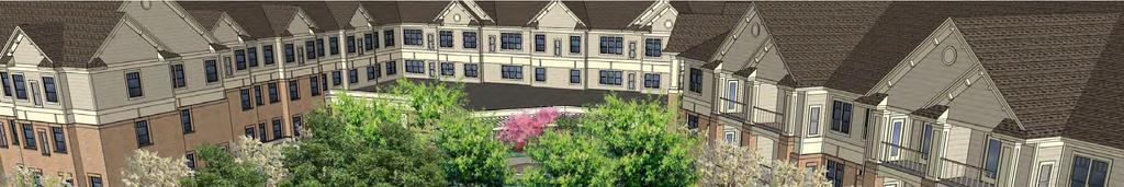
16 Planning Review March 11, 2014 Rose Senior Living at Providence Page 2 of 5 JSP13-81 in the use of public services, facilities and utilities, and will not place an unreasonable burden upon the subject property, surrounding land, nearby property owners and occupants, or the natural environment. [The applicant has provided the required Community Impact Statement detailing minimal impacts on the use of public services, facilities and utilities. Additionally, environmental impacts have been assessed and mitigation proposed (where necessary) as outlined in the wetland and woodland review letters.] c) In relation to the underlying zoning or the potential uses contemplated in the City of Novi Master Plan, the proposed development will not cause a negative impact upon surrounding properties. [The proposed building has been substantially buffered by existing and created natural features and should minimally impact the surrounding properties.] d) The proposed development will be consistent with the goals and objectives of the City of Novi Master Plan, and will be consistent with the requirements of this Article [Article 23B]. [The proposed development meets the stated intent of the PSLR Overlay District to encourage transitional uses between higher intensity office and retail uses and lower intensity residential uses while maintaining the residential character of the area as outlined in this review letter.] The City Council, after review of the Planning Commission's recommendation, consideration of the input received at the public hearing, and review of other information relative to the PSLR Overlay Development Agreement Application and PSLR Overlay Concept Plan, may Indicate its tentative approval of the PSLR Overlay Development Agreement Application and PSLR Overlay Concept Plan, and direct the City Administration and City Attorney to prepare, for review and approval by the City Council, a PSLR Overlay Development Agreement or deny the proposed PSLR Overlay Concept Plan. If tentative approval is offered, following preparation of a proposed PSLR Overlay Development Agreement, the City Council shall make a final determination regarding the PSLR Overlay Concept Plan and Agreement. After approval of the PSLR Overlay Concept Plan and Agreement the applicant may proceed with the standard site plan review and approval procedures outlined in Section 2307B and Section Ordinance Deviations Section 2304B permits deviations from the strict interpretation of the Zoning Ordinance within a PSLR Overlay agreement. These deviations can be granted by the City Council on the condition that there are specific, identified features or planning mechanisms deemed beneficial to the City by the City Council which are designed into the project for the purpose of achieving the objectives for the District. The applicant shall provide substitute safeguards for each item that does not the meet the strict requirements of the Zoning Ordinance. The concept plan submitted with an application for a PSLR Overlay is not required to contain the same level of detail as a preliminary site plan. Staff has reviewed the concept plan inasmuch detail as possible to determine what deviations from the Zoning Ordinance are currently shown. The applicant has elected to proceed with the plan as submitted with the understanding that those deviations would have to be approved by City Council in a proposed PSLR Overlay agreement. The following are deviations from the Zoning Ordinance and other applicable ordinances shown on the concept plan: 1. Front Yard Parking: Per Section 2305B.1.d of the Zoning Ordinance, developments utilizing the PSLR Overlay option cannot have parking in the front yard and parking in side and rear yards must be screened by a 3-5 ft. undulating berm. The applicant has proposed front yard parking in the southern yard and a minimum berm height of 2 ft. and requested these deviations be included in the PSLR Overlay Agreement. The applicant has provided a narrative discussing the proposed deviation (identified as Deviation #5 and Waiver #1A in the applicant s material) noting significant screening by natural features from the adjacent major roads and the functional need for front
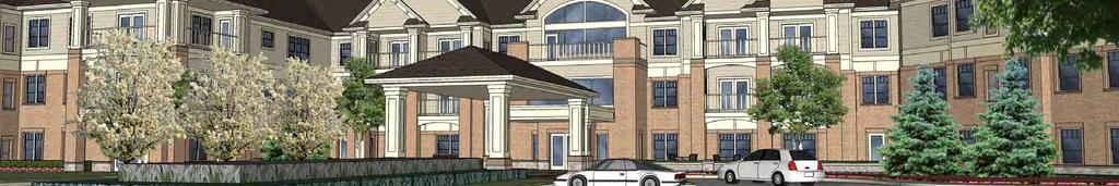
17 Planning Review March 11, 2014 Rose Senior Living at Providence Page 3 of 5 JSP13-81 yard parking on the double-fronted lot. It is staff s opinion that these deviations should be included in the PSLR Overlay Agreement. 2. Maximum Building Length: The maximum building length permitted in the PSLR Overlay is 360 ft. provided a waiver is granted by the City Council and additional setbacks have been provided. While the applicant has met the conditions for a potential waiver as identified in the planning review chart, the total proposed building length is 467 ft. This would require a deviation to be included in the PSLR Overlay Agreement. The applicant has provided a narrative discussing the proposed deviation (identified as Deviation #1 in the applicant s material) noting the unique building design that serves to break up the building façade creating the illusion of several buildings as opposed to a extended expanse of building facade. It is staff s opinion that this deviation should be included in the PSLR Overlay Agreement. 3. Maximum Building Height: The PSLR Overlay Ordinance contains specific factors in Section 2305B.3 detailing façade standards for any proposed buildings. These standards are intended to require buildings that are residential in character and style and note detailed standards to evoke such a design. One such feature limits the building height to 35 ft. or 2.5 stories. The applicant has proposed a building totaling 41 ft. at the midpoint of the roof and has provided information in their narrative discussing the proposed deviation (identified as Deviation #2 in the applicant s material). The façade review notes that the design generally meets the intent of the PSLR Overlay Ordinance and staff would support the proposed deviation. See the façade review letter for additional information. 4. Façade Design: The applicant has proposed a façade that does meet all of the requirements noted in the PSLR Overlay Ordinance. In particular, the proposed façade has pedestrian entrances spaced more than 60 feet apart and exceeds the maximum percent allowed of asphalt shingles (70%). These are discussed in the applicant s narrative as Deviation #3 and Deviation #4. The City Council may permit building designs that do not meet the Ordinance requirements with a finding that the design meets the intent of the ordinance. The façade review notes that the design generally meets the intent of the PSLR Overlay Ordinance and staff would support the proposed deviations. See the façade review letter for additional information. 5. Accessory Carports: The applicant has proposed carports in both the northern and western yards. Accessory structures are permitted in the rear (northern) yard only. The carports proposed in the interior side (western) yard would require a deviation from the ordinance requirements. The applicant has provided information concerning the proposed deviation (identified as Deviation #6 in the applicant s material). Given the fact that the proposed parcel will have two road frontages, it is staff s opinion that this deviation should be included in the PSLR Overlay Agreement. 6. Signage: Per the Sign Code, a business ground sign or an entranceway sign are permitted for this development. The applicant has proposed both a business sign and an entranceway sign. This development is allowed one ground sign, either the entranceway sign located at Beck Road or the business sign located within the development. The location of the proposed entranceway sign and size appear to be in compliance with the ordinance requirements for both the sign ordinance and Zoning Ordinance corner clearance requirements. The proposed business sign complies with the size and height allowances but the setback is not indicated on the plan to determine if the location is in compliance. The applicant has provided information concerning the proposed deviation to allow both a business sign and an entranceway sign (identified as Deviation #7 in the applicant s material). Staff would not object to the inclusion of this deviation in the PSLR Overlay Agreement given the distance between Beck Road and the actual entrance to the site. 7. Access Points: Section 2305B.2 of the Zoning Ordinance states that access drives for new building sites should be connected only to non-section line roads. An access drive has been proposed on Beck Road, a section line road. The applicant has discussed the proposed deviation in their provided narrative (identified as Deviation #8 in the applicant s material) and noted that the Beck Road access is needed to provide a secondary point of access for emergency vehicles and to aid visitors and residents in locating and accessing the site. The traffic review notes no objection to the proposed deviation and also notes that the traffic volumes generated by the proposed use will be relatively low.
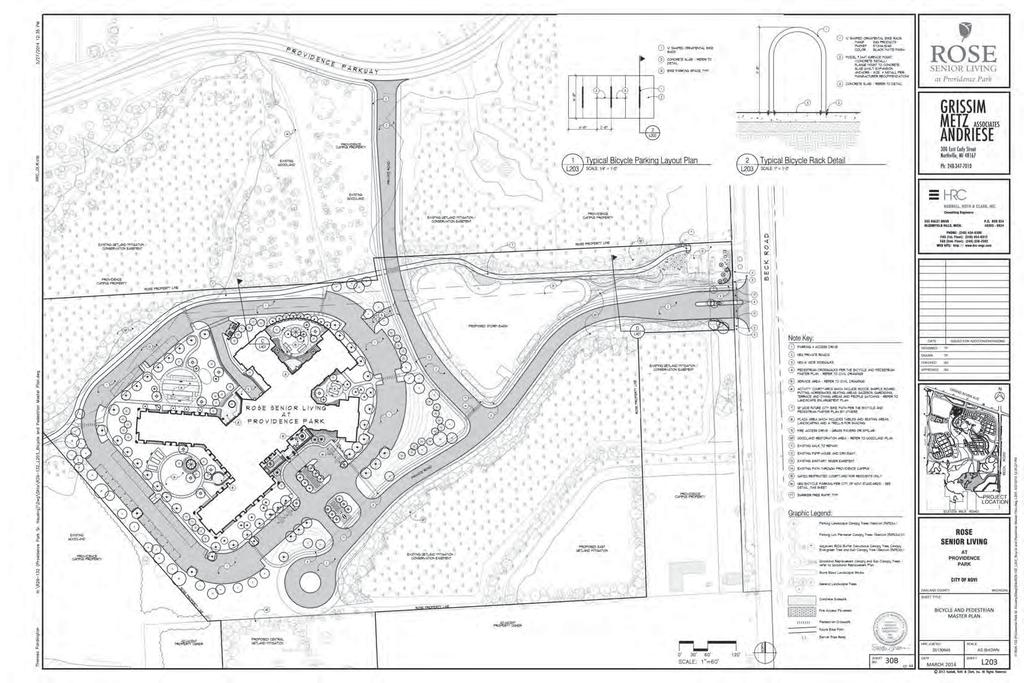
18 Planning Review March 11, 2014 Rose Senior Living at Providence Page 4 of 5 JSP Landscape waivers: The landscape review includes a detailed list of required and provided items. The applicant is requesting three waivers to be included in the PSLR Overlay Agreement. The waiver to permit a 2 ft. berm height for the required parking screening as opposed the required 3 ft. height has been noted previously in this letter and is supported by staff. The Ordinance also requires a 3 to 5 ft. berm within the proposed greenbelt along Beck Road. The applicant has proposed a 1.5 to 5 ft. high wall where installation of a berm is not feasible due to the preservation of natural features and an existing landscape berm and has provided a supporting narrative (identified as Waiver 1B in the applicant s materials). Staff would support inclusion of the requested waiver in the PSLR Overlay Agreement. A 4 ft. wide landscape bed is required around the entire building foundation and the applicant has elected to request a waiver of this item and has provided significant landscaping within the proposed courtyards in lieu of the foundation plantings. This is discussed in the applicant s narrative as Waiver #2. Staff would support the inclusion of this waiver in the PSLR Overlay Agreement. See the landscape review letter for additional information. 9. Storm Basin over Sanitary Sewer Easement: The applicant has proposed the stormwater detention basin be constructed over an existing sanitary sewer easement. This would not be in compliance with Section (a)(2) of the Design and Construction Standards and would require a variance. Engineering staff does not support the proposed variance. See the engineering review letter for additional information. The applicant has provided information discussing the proposed variance as part of their application materials (identified as Deviation #11 in the applicant s material). 10. Deviations and Waivers not Required: The applicant has provided information and narratives describing deviations required from Chapter 5 Section 1.2(D) of the City Code and Section of the Design and Construction standards (identified as Deviation #9 and Deviation #10 in the applicant s material). Per the engineering review letter these deviations are not required. Authorizations to encroach on required wetland buffer areas are addressed and can be granted administratively as part of the Preliminary Site Plan review and approval. Therefore, Waiver #3 in the applicant s narrative will not be addressed at this time. Ordinance Requirements This project was reviewed for conformance with Article 23B (PSLR Planned Suburban Low-Rise Overlay District), Article 24 (Schedule of Regulations), Article 25 (General Provisions) and any other applicable provisions of the Zoning Ordinance. Items in bold below must be addressed by the applicant and or Planning Commission/City Council. 1. PSLR Concept Plan Requirements: A PSLR Concept Plan must contain a number of items as outlined in Sections 2304B and 2305B of the Zoning Ordinance. The applicant has submitted the majority of these items including the required Community Impact Statement. Also required are the identification of open space and recreation areas and a Bicycle/Pedestrian Master Plan. While these features have been incorporated into the plan set, the applicant should include a plan sheet labeled Bicycle and Pedestrian Master Plan as well as a sheet labeled Open Space and Recreation identifying the relevant elements. 2. Outdoor Lighting: The applicant should provide a photometric plan and accompanying details to comply with Ordinance requirements at the time of Preliminary Site Plan review. 3. Proposed sidewalk: The applicant has proposed a 5 ft. sidewalk along the private drive. Per the Non-Motorized Master Plan this sidewalk should be increased to 6 ft. in width. 4. Parking Space Dimensions: The applicant should indicate 4 curbs wherever 17 ft. spaces are proposed. 5. Maximum Lot Coverage: Maximum lot coverage by all buildings cannot exceed 25%. The applicant has indicated lot coverage of less than 10% in their response letter. Lot coverage statistics should be provided on the plan set. 6. Bicycle Parking Facilities: The applicant has provided the required bicycle parking. However, details for the bicycle parking areas have not been shown. The applicant should provide a
19 Planning Review March 11, 2014 Rose Senior Living at Providence Page 5 of 5 JSP13-81 bicycle parking detail demonstrating compliance with the layout standards detailed in Section Property Split: The proposed property split must be submitted to the Assessing Department for approval. 8. Economic Information: The applicant has the estimated that the proposed development will generate $625,000 to $656,000 in property taxes based on the current City millage. Approximately 150 jobs will be generated during the construction of the site and approximately 80 full and 20 part-time positions will be created at final build-out. 9. Environmental Impacts: There are significant natural features on the site that are detailed in the wetland and woodland review letters. The wetland and woodland permits themselves will not be considered until consideration of the Preliminary Site Plan. Site Addressing The applicant should contact the Building Division for an address prior to applying for a building permit. Building permit applications cannot be processed without a correct address. The address application can be found on the Internet at under the forms page of the Community Development Department. Please contact Jeannie Niland [ ] in the Community Development Department with any specific questions regarding addressing of sites. Street and Project Name This project may need approval from the Street and Project Naming Committee. Please contact Richelle Leskun ( ) in the Community Development Department for additional information. Pre-Construction Meeting Prior to the start of any work on the site, Pre-Construction (Pre-Con) meetings must be held with the applicant s contractor and the City s consulting engineer. Pre-Con meetings are generally held after Stamping Sets have been issued and prior to the start of any work on the site. There are a variety of requirements, fees and permits that must be issued before a Pre-Con can be scheduled. If you have questions regarding the checklist or the Pre-Con itself, please contact Sarah Marchioni [ or smarchioni@cityofnovi.org] in the Community Development Department. Chapter 26.5 Chapter 26.5 of the City of Novi Code of Ordinances generally requires all projects be completed within two years of the issuance of any starting permit. Please contact Sarah Marchioni at for additional information on starting permits. The applicant should review and be aware of the requirements of Chapter 26.5 before starting construction. Response Letter A letter from either the applicant or the applicant s representative addressing comments in this and other review letters is required prior to consideration by the Planning Commission and with the next plan submittal. If the applicant has any questions concerning the above review or the process in general, do not hesitate to contact me at or kkapelanski@cityofnovi.org. Kristen Kapelanski, AICP, Planner Attachments: planning review chart
20 Planning Review Summary Chart Rose Senior Living at Providence JSP13-81 PSLR Concept Plan Review Plan Dated: 02/18/14 Bolded items must be addressed by the applicant. Item Property is Master Planned for Planned Suburban Low- Rise (PSLR) Zoning is currently Planned Suburban Low- Rise/R-3 Uses allowed include multiple-family, congregate elderly living, assisted living/convalescent homes, live/work units, day care centers, offices, religious uses, schools, community buildings (Sec. 2303B) Proposed No change No change Assisted living Meets Required? Yes Yes Yes, subject to special conditions Comments PSLR Agreement and PSLR Concept Plan must be approved by the City Council. Special Land Use Permit required. PSLR Standards (Sec. 2304B and 2305B) PSLR Concept Plan must contain the following: Legal description and dimensions Existing zoning of site/adjacent properties Existing natural features and proposed impacts Existing and proposed rights-of-way and road layout Bicycle/pedestrian plan Conceptual utility plan Setback requirements Conceptual layout Conceptual open space/recreation Conceptual landscape plan Buildings shall front on a dedicated non-section line public street or an approved private drive Plan set provided. Yes? While this information has generally been provided in the plan set, for clarification purposes, the applicant should include a plan sheet labeled Bicycle and Pedestrian Master Plan as well as a plan sheet labeled Open Space and Recreation Frontage on an approved private drive Yes
21 Item Building Setbacks: Front (south): Min. 30 ft. Max. 75 ft. Ext. Side (east): Min. 30 ft. Max. 75 ft. Int. Side (west): 30 ft. Rear (north): 30 ft. Proposed Front (south): 578 ft. Ext. Side (east): 795 ft. Int. Side (west): 142 ft. Rear (north): 90 ft. Meets Required? Yes Comments Building Setbacks to accommodate a building up to 360 ft. long Front (south): Min. 90 ft. Ext. Side (east): Min. 90 ft. Int. Side (west): 90 ft. Rear (north): 90 ft. All buildings, parking lots and loading areas shall be separated from section line road rights-of-way by a 50 ft. landscape buffer containing an undulating 3-5 ft. tall landscaped berm. Off-Street parking standards: Located in the rear or interior side yard Screened by 3-5 ft. undulating berm Min. 15 ft. from all buildings Setbacks: Front (south): Not permitted Ext. Side (east): Min. 30 ft. Int. Side adjacent to single-family residential (west): 30 ft. Parcel does not abut a section line road. Located in all yards Berm indicated (min. 2 in height) Min. 20 ft. from building Front: parking proposed Ext. Side: 490 ft. Int. Side: 30 ft. N/A No Applicant should adjust site layout to remove the front yard parking and increase the minimum berm height by 1. -OR- City Council may approve deviations from the Ordinance standards as part of a PSLR Overlay Development Agreement provided there are specific, identified features or planning mechanisms deemed beneficial to the City which are designed into the project for the purpose of achieving the objectives for the District. Safeguards shall be provided for each regulation where there is noncompliance on the PSLR Overlay Concept Plan.
22 Item Proposed Meets Required? Comments Loading and unloading Loading area Yes area must be provided identified on the north side of the building Max. Building Length 180 ft. 467 ft. No Applicant should adjust the layout to accommodate the maximum permitted building length. Site layout does meet the standards identified below that permit a waiver of building length by City Council up to 360 ft. However, since the building exceeds 360 ft., the City Council may consider a variance from the ordinance provisions. -OR- Streetscape amenities must be included Outdoor Lighting Amenities shown on landscape plan No lighting plan provided Yes The City Council may modify the maximum permitted building length if the building includes common areas with (1) a minimum capacity of 50 people for dining, recreation or social activities and (2) The building is setback an additional 1 ft. for every 3 ft. of building length in excess of 180 ft. from all property lines abutting a residential district. In no case can the building exceed 360 ft. Applicant should provide a lighting plan consistent with the standards identified in Section 2511 and Section 2305B.1.j of the Zoning Ordinance with the Preliminary Site Plan submittal.
23 Item Circulation Standards Full time access drives shall be connected only to non-section line roads New roads shall be designed as pedestrian/bicycle focused corridors as identified in the Non- Motorized Master Plan Facilities shall be connected to the existing pedestrian network Max. Bldg. Height 35 ft. or 2 ½ stories Buildings must be designed with a single-family residential character Proposed Full-time access provided see traffic review letter New roadway includes a 5 sidewalk, pedestrian crossings, and a refuge island near the main intersection with Beck Road Connected to existing pedestrian network 41 ft. to roof midpoint Meets Required? No No Comments Sidewalk should be increased to 6 in width. Applicant should adjust the building design to meet the required height. -OR- The City Council may permit building designs that do not meet the Ordinance requirements with a finding (following a positive staff recommendation) that the design meets the intent of the district. Parking Area Requirements (Sec and 2506) Congregate Care: 3 spaces for each 4 units and 1 for each employee 69 units/4x3=52 spaces Assisted Living: 1 space for each 4 beds and 1 for each employee 119 beds/4 = 30 spaces 65 employees = 65 spaces 181 spaces provided Yes See the façade review comments for additional information.
24 Item Proposed Meets Required? Comments = 147 spaces required Parking Space Dimensions and Maneuvering Lanes 9 x 19 parking space dimensions and 24 wide drives. 9 x 17 parking spaces allowed along 7 wide interior sidewalks as long as detail indicates a 4 curb at these locations and along landscaping. Barrier Free Spaces (Barrier Free Code) 6 barrier free spaces required (1 van accessible) Barrier Free Space Dimensions (Barrier Free Code) 9 x 19 parking space dimensions and min. 26 wide drives. 9 x 17 parking spaces proposed along 7 wide interior sidewalks 8 barrier free spaces proposed (4 van accessible) Barrier free spaces dimensioned correctly Yes Yes Yes Applicant should indicate a 4 curb wherever 17 spaces are proposed 8 wide with a 5 wide access aisle for standard barrier free spaces, and 8 wide with an 8 wide access aisle for van accessible spaces Barrier Free Signs (Barrier Free Design Graphics Manual) Barrier free signage included Yes One sign for each accessible parking space. General Requirements Maximum lot coverage by all buildings cannot exceed 25% (Sec. 2400) Accessory Structure Setback- Dumpster (Sec. 2503) Accessory structures should be setback a minimum of 10 feet from any building unless Lot coverage less than 10% (as indicated in response letter Dumpsters indicated in the rear yard setback and screened appropriately Yes Yes The applicant should provide maximum lot coverage statistics on the plan set.
25 Item structurally attached and setback the same as parking from all property lines; the structure must be in the rear or interior side yard. Dumpster (Chap. 21, Sec ) Proposed Meets Required? Comments Screening of not less than 5 feet required, interior bumpers or posts required. Enclosure to match building materials and be at least one foot taller than height of refuse bin. Accessory Structure Carport (Sec ) Shall be located in the rear yard and shall meet the building setback requirements of the district. Carports located in the rear and interior side yards Int. Side Future (west): 30 ft. Rear (north): 90 ft. No Staff would support a deviation from the Ordinance to allow a carport in the interior side yard. Building Setbacks: Int. Side (west): 30 ft. Rear (north): 30 ft. Bicycle Parking Facilities (Sec. 2526) 1 space for each 20 employees on the largest shift (minimum 2 spaces) 65 employees/20 = 3 Spaces required 6 spaces provided located near the main entrance and accessible via a 7 walkway Details not provided Yes? The applicant should provide a detail for the required bike parking. Shall be located along the building approach line and easily accessible from the building entrance Max. 120 feet from entrance being served or the nearest auto parking space to that entrance Must be accessible via a paved 6 foot wide route
26 Item and separated from auto facilities Proposed Meets Required? Comments 4 foot wide maneuvering lane required with a 6 foot parking space width and a depth of 2 feet for single spaces and 2.5 feet for double spaces Development/Business Sign Signage if proposed requires a permit Review Prepared by Kristen Kapelanski, AICP kkapelanski@cityofnovi.org or See the included sign review memo
27 Engineering Review
28
29
30
31
32
33
34 Traffic Review

35 March 7, 2014 Barbara McBeth, AICP Deputy Director of Community Development City of Novi W. Ten Mile Rd. Novi, MI SUBJECT: Rose Senior Living at Providence Park, JSP , Traffic Review of Conceptual Site Plan, PSP Dear Ms. McBeth: At your request, we have reviewed the above and offer the following recommendations and supporting comments. Recommendation We recommend approval of the concept plan, subject to the needed variance being granted and the items shown below in bold being satisfactorily addressed on the preliminary site plan. Site Description What is the applicant proposing, and what are the surrounding land uses and road network? 1. The applicant is proposing a three-story building containing 182 residential units, central dining, activity rooms, and other amenities. The residential units, as described by the applicant s traffic consultant, would include 75 assisted-living units, 69 congregate care/independent-living units, 38 memory-care units, and two guest suites. 2. The building will be located south of Providence Park Drive and west of Beck Road, between two large wetlands (see attached aerial photo). Vehicular access would be provided via a direct drive on Beck Road as well as a connection to Providence Park Drive (the latter is signalized at its intersection with Beck). Traffic Study and Trip Generation Was a traffic study submitted and was it acceptable? How much new traffic would be generated? 3. The applicant s traffic consultant, in a letter to us dated , provided a trip generation table assuming that all residential units would be any one of the four ITE land uses bracketing the ones represented in the proposed building. None of the four use types would generate enough peak-hour trips to warrant a formal traffic study. The highest number of peak-hour, peak-direction trips would be 37, or half of the City s threshold for an impact assessment. Vehicular Access Locations Do the proposed driveway locations meet City spacing standards? Clearzoning, Inc Southfield Road, Lathrup Village, Michigan Planning Zoning Transportation
36 Rose Senior Living at Providence Park, Traffic Review of Concept Plan P a g e 2 4. Section 2305B.2 of the Zoning Ordinance states that All uses that include the construction of a new building shall be designed, to the extent possible, with full time access drives connected only to non-section line roads (emphasis added). Since a direct access drive on Beck has been proposed, it appears that a variance is required. In considering that variance, it should be noted that the site would also have a connection to Providence Park Drive (which is signalized at Beck), and the total peak-hour traffic generated by the proposed use will be relatively low. 5. As can be seen in the attached vicinity aerial photo, there are no other driveways of consequence in the general proximity of the proposed new access drive on Beck. Vehicular Access Improvements Would there be any improvements to the abutting road(s) at the proposed access point(s)? 6. None are proposed. However, given that historic count data show Beck Road carrying more than 17,000 vehicle per day adjacent to the site, DCS Fig IX.10 indicates that a deceleration taper is warranted regardless of the number of peak-hour entering right turns. Accordingly, City-minimum 75-ft acceleration and deceleration tapers should be added at the Beck Road drive. These tapers should transition smoothly (or tangentially) into and out of the curb returns (hence, the latter will complete less than the normal 90-degree arc). Access Drive Design and Control Are the proposed design, pavement markings, and signage satisfactory? 7. The designs of the north and east access points, where shown at maximum scale (on sheets C-06 and C-08, respectively), should be dimensioned. By scaling, however, we note that: a. At the connection to Providence Park Drive, Rose s north access drive would be 40-ft wide, striped into separate left-only and right-only lanes over the northernmost 100 ft, and equipped with 25-ft-radius curb returns. Given the proposed width near the intersection, the southbound lane should be slightly wider than the two northbound lanes. No later than the final site plan, a STOP (R1-1) sign should be proposed, along with pavement marking specifications. b. The preceding guidance also applies where the north-south access drive intersects the east-west access drive. c. At the connection to Beck, Rose s east access drive would be a modified version of the Citystandard boulevard-style drive. The entering roadway would be the City-minimum width of 22 ft, the island would be the City-minimum width of 8 ft, and it appears that the exiting roadway would exceed the City-maximum width of 27 ft by 1 ft. We support the proposed entering width, but (i) given the presence of the proposed monument sign on the island, the island should be at least the City-standard width of 10 ft (per DCS Fig IX.3), and (ii) the exiting (eastbound) roadway should be reduced in width to 27 ft (back-to-back). Clearzoning Southfield Road, Lathrup Village, Michigan Planning Zoning Transportation
37 Rose Senior Living at Providence Park, Traffic Review of Concept Plan P a g e 3 d. Also along the east access drive near Beck, the curb returns appear to have an acceptable radius of 30 ft. These returns will obviously have to be set back to accommodate the required decel/accel tapers. The nose offset of the island appears to be only 9-10 ft relative to the southbound through lane, and it must be increased to at least the City standard of 12 ft. No later than the final site plan, a STOP (R1-1) sign should be proposed, along with pavement marking specifications. Pedestrian Access Are pedestrians safely and reasonably accommodated? 8. Yes, in general. However, subsequent plans should show the locations of all required pedestrian ramps, both internal to the building loop and at more remote site locations. Circulation Can vehicles safely and conveniently maneuver through the site? 9. Yes, in general. There are several instances where oversize elements have been provided, presumably to facilitate easier circulation by large emergency vehicles. For example, a 26-ftwide aisle is proposed between opposing lines of parking and a 30-ft width is proposed along segments of the building loop with no abutting parking. In the interest of minimizing the amount of impermeable surface, the City may want the applicant to reconsider the need for these over-width elements (especially the 30-ft-wide segments). 10. Driveway centerline radii and curb return radii appear to be generally sufficient, but all should be dimensioned on the preliminary site plan so as to facilitate our more detailed review at that stage (repetitive radii can be labeled as typical ). 11. It is unclear what the intended accessible routes would be for the two banks of barrier-free parking spaces. While an ADA-compliant ramp could be provided on the end-island sidewalk stub shown for the westerly bank of spaces, the long implied detectible warning surface adjacent to the easterly bank of spaces seems to indicate that these spaces and their access aisles would all be flush with the abutting sidewalk (the grading plan sheds no light on this). Wherever feasible, the edge of a raised (or ramped) sidewalk should serve as a positive wheel stop in at least one wheel track of each parking space; where infeasible such as adjacent to the two inner barrier-free spaces here a single 4-inch-high bumper block should be placed straddling both spaces, with at least 17 ft of stall striping leading up the parking face of the block (the block may have to rest on the edge of the walk). 12. Perimeter parking spaces not equipped with carports could be shortened to 17 ft (to face of curb) if the adjacent curb is limited in height to 4 inches. The applicant s engineer may wish to discuss this issue with City engineering staff. 13. The raised speed table proposed on the north-south connecting drive should be limited in height to 3 inches and equipped (at a minimum) with a SPEED HUMP (W17-1) sign. Clearzoning Southfield Road, Lathrup Village, Michigan Planning Zoning Transportation
38 Rose Senior Living at Providence Park, Traffic Review of Concept Plan P a g e The gate proposed on the requested secondary emergency access connection to the northsouth connecting drive should be fully specified on subsequent plans (see DCS Fig VIII-K). 15. The cul-de-sac turnaround should include a non-diagrammatic Keep Right -> (R4-7a) sign on the island on the approaching street centerline, and be posted on both sides using 12 x 12 No Parking Symbol (R8-3) signs. 16. Subsequent plans should include a note assuring compliance with the Michigan Manual on Uniform Traffic Control Devices. This will require, for instance, the use of yellow for striped centerlines and white for lane lines, stop bars, crosswalks, and undesignated parking space stripes. Relative to items already shown on the concept plan, it will also require: a. Abutting blue and white stripes where a barrier-free parking space abuts an undesignated space (the detail on sheet C-08 needs to be revised accordingly). b. White International Symbols of Accessibility (wheelchairs). c. A code of R7-8P for the VAN ACCESSIBLE sign (formerly R7-8a). Sincerely, CLEARZONING, INC. Rodney L. Arroyo, AICP President William A. Stimpson, P.E. Director of Traffic Engineering Attachment: Aerial photo Clearzoning Southfield Road, Lathrup Village, Michigan Planning Zoning Transportation

39 Signal SITE Vicinity Aerial Proposed Rose Senior Living at Providence Park
40 Landscape Review
41 PLAN REVIEW CENTER REPORT March 13, 2014 Concept Plan Rose Senior Living at Providence JSP13-81 Review Type Concept Plan Review Property Characteristics Site Location: Beck Road Site Zoning: R-3 / Suburban Low Rise Adjacent Zoning: Suburban Low Rise; North: R-3 Plan Date: February 2014 (no date) Recommendation Approval of the Concept Plan for Rose Senior Living JSP is recommended provided the necessary waivers are included in the Planned Suburban Low Rise Overlay Agreement. Ordinance Considerations Required PSLR Overlay Use Standards/Conditions for uses permitted subject to special conditions (Sec. 2503B.3.i) 1. Landscaping throughout the site shall be provided as set forth and regulated in Section 2509 of this Ordinance. All sites shall include streetscape amenities such as but not limited to benches, pedestrian plazas, etc. In light of the proposed plazas, outdoor activity spaces and amenities, the Applicant will meet this standard. Such features should by highlighted by the Applicant. Suburban Low-Rise Requirements (Sec. 2305B) 1. Off-street parking is required to be screened from the view from adjacent streets by a 3 to 5 undulating landscape berm. The Applicant has proposed a 2 to 5 high berm. The area of the 2 high berm is limited and is due to the fact that a taller berm cannot be installed. This area is screened by natural features and will be landscaped. A waiver for a berm less than 3 would be required in this limited area. Staff would support the waiver. 2. In Suburban Low-Rise Districts, amenities such as but not limited to benches, pedestrian plazas, etc. are to be included on the site. The Applicant has provided significant amenities with the facility meeting these requirements. Adjacent to Public Rights-of-Way Berm (Wall) & Buffer (Sec b.) 1. A 50 wide greenbelt is required along Beck Road. This requirement has been met. 2. A 3 to 5 undulating berm is required within the greenbelt. An existing landscape berm will be preserved for a significant portion of this frontage. Due to limited space, the Applicant has proposed installing a berm where possible
42 Preliminary Landscape Plan March 13, 2014 Rose Senior Living Page 2 of 3 along the remainder of the frontage. The Applicant has proposed a 1.5 to 5 high wall in order to meet the buffering requirements where installation of a berm is not feasible. The decorative wall would need to be included as a deviation in the Planned Suburban Low Rise Agreement. Staff would support the waiver. 3. One canopy tree or large evergreen is required for each 35 l.f. of frontage. Along with existing trees to be preserved, this requirement has been met. 4. One sub-canopy tree for each 20 l.f. is required. This requirement has been met. Street Tree Requirements (Sec b.) 1. One street tree is required per each 35 l.f. of frontage. Existing trees will be preserved and additional trees are proposed. This requirement has been met. Parking Landscape (Sec c.) 1. Required calculations for parking lot area landscape have been provided. This requirement has been met. 2. Required calculations for parking lot canopy trees have been provided. This requirement has been met. 3. Parking lot islands are required. No more than 15 contiguous parking spaces are allowed. This requirement has been met. Parking Lot Perimeter Canopy Trees (Sec c.(3)) 1. Parking lot perimeter trees are required at one per 35 of the parking lot boundary. This requirement has been met. Building Foundation Landscape (Sec d.) 1. A 4 wide landscape bed is required around the entire building foundation with the exception of access areas. The Applicant has provided significant landscape within all of the proposed courtyards, but has not provided 4 wide beds at every portion of the building foundation. A waiver would be required in the Planned Suburban Low Rise Agreement for those areas of the foundation where a 4 wide landscape bed has not been provided. In light of the expansive landscape and amenities provided in the direct vicinity of the building, Staff would support the waiver. 2. A total of 8 x the foundation perimeter is required as landscape area. This requirement has been met. Plant List (LDM) 1. A Plant List meeting the requirements of the Ordinance and the Landscape Design Manual has been provided. Planting Notations and Details (LDM) 1. Planting Details and Notations meeting the requirements of the Ordinance and the Landscape Design Manual have been provided. Storm Basin Landscape (LDM) 1. A total of 70-75% of the storm basin rim areas is required to be planted with large shrubs. Please provide additional details on the basin plantings to assure this
43 Preliminary Landscape Plan March 13, 2014 Rose Senior Living Page 3 of 3 requirement has been met. Please also depict the required 25 wetland buffer around the basin on the plan. Irrigation (Sec f.(6)(b)) 1. An Irrigation Plan and Cost Estimate must be provided upon future submittals. Please follow guidelines of the Zoning Ordinance and Landscape Design Guidelines. This review is a summary and not intended to substitute for any Ordinance. For the landscape requirements, see the Zoning Ordinance landscape section on 2509, Landscape Design Manual and the appropriate items in the applicable zoning classification. Reviewed by: David R. Beschke, RLA
44 Wetland Review
 Wetland Review of the Conceptual Plan")
45 March 11, 2014 Ms. Barbara McBeth Deputy Director of Community Development City of Novi West Ten Mile Road Novi, MI Re: Rose Senior Providence (JSP ) Wetland Review of the Conceptual Plan (PSP ) Dear Ms. McBeth: Environmental Consulting & Technology, Inc. (ECT) has reviewed the Conceptual Plan (Plan) for the proposed Rose Senior Living at Providence Park project prepared by Hubbell, Roth & Clark, Inc. dated February 18, 2014 (Plan). The Plan was reviewed for conformance with the City of Novi Wetland and Watercourse Protection Ordinance and the natural features setback provisions in the Zoning Ordinance. The project includes the construction of a proposed assisted living building, associated parking areas, a proposed storm water detention basin and proposed wetland mitigation areas. ECT previously received a request to conduct a wetland boundary verification for the abovementioned project and completed a site investigation on Thursday, January 23, 2014 with the Applicant s wetland consultant, Brooks Williamson & Associates, Inc. (Don Berninger). The proposed site is located west of Beck Road, south of Grand River Avenue and north of Eleven Mile Road (Section 17). The proposed project is south of the existing Providence Hospital. The Plans prepared by Hubbell, Roth & Clark, Inc., dated February 18, 2014 show six wetlands within the assessment area of the parcel. The wetlands were clearly marked in the field with survey tape flags at the time of our inspection; however wetland flag numbers were not shown on the Plan. ECT has verified that the wetland boundaries appear to be accurately flagged in the field and depicted on the Plan. However, given the winter, snow-covered conditions during the time of our inspection, the results should be considered preliminary in nature. This preliminary wetland boundary verification/approval should be adequate for preliminary site planning purposes. We suggest that a final wetland boundary verification be completed during the growing season, and minor adjustments to the wetland boundary made if necessary. Wetland Impact & Proposed Wetland Mitigation Review The Wetland Mitigation Plan indicates impacts to each of the six different wetland areas totaling 1.43 acres of impact. The majority of the wetland acreage to be impacted consists of forested wetlands (1.36 acres of proposed impact to forested wetlands and 0.07-acre of impact to emergent wetlands) Commonwealth Boulevard, Suite 300 Ann Arbor, MI (734) FAX (734) The Plan indicates proposed wetland mitigation in three locations (west, central and east) totaling 2.86 acres. During the site investigation we reviewed the three potential wetland mitigation area locations. Each of the three potential wetland mitigation areas appeared to be suitable for this purpose given their location relative to existing wetlands. The west potential mitigation area is located within an area currently mapped as City-regulated woodlands and may require further An Equal Opportunity/Affirmative Action Employer
46 Rose Senior Providence (JSP ) Wetland Review of the Conceptual Plan (PSP ) March 11, 2014 Page 2 of 4 evaluation. The central and east mitigation areas are located outside of areas currently mapped as City-regulated woodlands. It should be noted that based on the Plan, the Applicant now appears to be providing wetland mitigation at a ratio of 2-to-1 (2 acres of wetland mitigation for every 1-acre of proposed wetland impact). In general, the wetland mitigation requirement for impacts to forested wetland is 2-to-1. The following is a summary of the proposed wetland mitigation areas: Mitigation Area Area (Acres) West 0.61 Central 1.23 East 1.02 TOTAL 2.86 Permits & Regulatory Status It appears as though a MDEQ Wetland Permit, City of Novi Wetland Non-Minor Use Permit and Authorization to Encroach the 25-Foot Natural Features Setback would be required for the proposed impacts. All of the wetlands appear to be considered essential by the City as they appear to meet one or more of the essentiality criteria set forth in the City s Wetland and Watercourse Protection Ordinance (i.e., storm water storage/flood control, wildlife habitat, etc.). It is the Applicant s responsibility to contact MDEQ in order to determine if the proposed development would require a wetland use permit from the MDEQ. The MDEQ s Coastal and Inland Waters Permit Information System (CIWPIS) notes that the permit application for this proposed project was received on February 19, The permit application has been assigned to a field reviewer. Comments Please consider the following comments when preparing subsequent site plan submittals: 1. The Applicant shall provide the following information on future site plan submittals: a) The existing wetland labels should be provided on the Plan for reference purposes (i.e., wetlands should be labeled as Wetland A, B, C or Wetland 1, 2, 3, etc.); b) Wetland flag numbers for all surveyed wetlands should be provided somewhere in the Plan set; c) In addition to wetland impact the areas, the overall acreages of all on-site wetlands should be provided; d) The volumes of proposed wetland fill should be indicated and labeled on the Plan; e) Indicate and label all 25-foot wetland buffers/setbacks on the Plan (including the overall acreages of all on-site wetland buffers); f) Indicate, label and quantify any proposed impacts to 25-foot wetland buffers on the Plan. 2. The Applicant has now provided proposed grading plans for each of the three proposed wetland mitigation areas (Conceptual Grading Plans; Sheets 1 through 3 of 3). In general, the proposed grading of the mitigation areas appears to be acceptable.
47 Rose Senior Providence (JSP ) Wetland Review of the Conceptual Plan (PSP ) March 11, 2014 Page 3 of 4 Prior to final approval, the Applicant shall provide a mitigation plan that includes the following information, and meets the requirements outlined in the Novi Code of Ordinances, Section (Chapter 12 Drainage and Flood Damage Prevention): a) Depiction and delineation of existing wetlands and watercourses in the vicinity of the proposed mitigation area; b) Depiction of existing contour data within the mitigation area as well as within any adjacent wetlands or watercourses, extending for a distance of at least seventy-five (75) feet into the wetland interior; c) Proposed contour data within mitigation areas using one-foot contours. Spot elevations shall be provided at critical locations (e.g. inverts of water control structures); d) A graphic scale, north arrow and date. The scale shall be one (1) inch equals fifty (50) feet or larger; e) Cross sections of critical areas; f) Identification of disposal areas for dredged material and depiction of the method of containment; g) A cost estimate for the purpose of establishing a bond amount, including, but not limited to, the cost of clearing, grading, soil placement, stabilization, planting and monitoring; h) Data indicating the expected hydrologic cycle, identifying the source of expected water levels, as well as the invert elevation of all water control structures; i) The limits of disturbance and methods of stabilization and erosion control; j) A list of proposed plant materials, which shall include the botanical and common names, quantities, size and spacing of plants and type of plants (e.g., bare root, balled and burlapped, containerized, etc.). 3. In addition to the wetland mitigation plan, the Applicant shall also provide a written summary of the goals and objectives of the mitigation plan. This summary shall include: A description of the size and type of wetland to be constructed; The hydrology expected; A timetable for construction and plantings, as well as a guarantee of plant materials for two (2) years. 4. The Applicant shall also provide as a part of the mitigation plan, a program to monitor the status of the replacement wetland for up to five (5) years after the wetland mitigation has been planted in the mitigation area. The monitoring program shall include annual progress reports submitted no later than December 1 of each year to the body approving the permit, which shall provide the following information: A measure of the percentage of coverage of wetland species versus upland species; A measure of vegetation diversity; A description of vegetation and animal community structure; A record and description of hydrological development; A written summary of wetland development describing the progression of wetland development; A photographic record of the wetland for each year.
48 Rose Senior Providence (JSP ) Wetland Review of the Conceptual Plan (PSP ) March 11, 2014 Page 4 of 4 5. The Applicant should provide a copy of the MDEQ Wetland Use Permit application to the City (and our office) for review and a copy of the approved permit upon issuance. A City of Novi Wetland Permit cannot be issued prior to receiving this information. Recommendation The Conceptual Plan is Approved as Noted for Wetlands. ECT recommends that the Applicant address the concerns noted in the Comments sections above in subsequent plan submittals. If you have any questions regarding the contents of this letter, please contact us. Respectfully submitted, ENVIRONMENTAL CONSULTING & TECHNOLOGY, INC. Pete Hill, P.E. Senior Associate Engineer cc: David Beschke, City of Novi, Licensed Landscape Architect Kristen Kapelanski, AICP, City of Novi Planner Angela Pawlowski, City of Novi, Senior Customer Service Sarah Roediger, City of Novi Planner
49 Woodland Review
50 March 11, 2014 Ms. Barbara McBeth Deputy Director of Community Development City of Novi W. Ten Mile Road Novi, Michigan Re: Rose Senior Providence (JSP ) Woodland Review of the Conceptual Plan (PSP ) Dear Ms. McBeth: Environmental Consulting & Technology, Inc. (ECT) has reviewed the Conceptual Plan (Plan) for the proposed Rose Senior Living at Providence Park project prepared by Hubbell, Roth & Clark, Inc. dated February 18, 2014 (Plan). The submittal was reviewed for conformance with the City of Novi Woodland Protection Ordinance Chapter 37. The project includes the construction of a proposed assisted living building, associated parking areas, a proposed storm water detention basin and proposed wetland mitigation areas. The proposed site is located west of Beck Road, south of Grand River Avenue and north of Eleven Mile Road (Section 17). The proposed project is south of the existing Providence Hospital. Onsite Woodland Evaluation ECT has reviewed the City of Novi Official Woodlands Map and completed an onsite Woodland Evaluation on Thursday, January 23, ECT found that the information provided on the Tree Survey Inventory plans (TS 01 to TS 10) appears to accurately depict the location, species composition and the size of the existing trees. ECT took several diameter-at-breast-height (d.b.h.) measurements and found that the data provided in the tree list was consistent with the field measurements. On-site woodland is dominated by silver maple, red maple, bitternut hickory, shagbark hickory, red oak, basswood and several other species. The entire site is shown to be acres with regulated woodland mapped across a significant portion of the property. See Figure 1 (aerial photo). Woodland Impact Review As shown, there appear to be substantial woodland impacts associated with the site construction. It appears as if the proposed work (proposed building, roads, utilities, storm water detention basin, and the west wetland mitigation area) will involve a considerable number of tree removals. It should be noted that the west potential wetland mitigation area is located within an area currently mapped as City-regulated woodlands and may require further evaluation Commonwealth Blvd., Suite 300 Ann Arbor, MI A Woodland Tree Replacement Chart has been included on the Woodland Impact Plan (Sheet L101). The Applicant has noted the following: (734) FAX (734) An Equal Opportunity/Affirmative Action Employer
51 Rose Senior Providence (JSP ) Woodland Review of the Conceptual Plan (PSP ) March 11, 2014 Page 2 of 5 No. of existing Trees to be removed: 620 Trees to be Removed 8 to 11 : 277 Trees (Requiring 277 Replacements) Trees to be Removed 11 to 20 : 203 Trees (Requiring 406 Replacements) Trees to be Removed 20 to 30 : 96 Trees (Requiring 288 Replacements) Trees to be Removed 30 +: 52 Trees (Requiring 208 Replacements) Total Replacement Trees Required: 1,179 Total Replacement Tree Credits Provided: 1,179 (The Applicant proposes to pay 0 credits to the City of Novi Tree Fund) The Woodland Replacement plans (L103 & L104) addresses the required woodland replacement tree credits by planting perennials, small shrubs, large shrubs, sub-canopy trees, evergreen trees and seeding. The Planning Commission may approve the planting of a variety of native woodland plants toward required woodland replacement credits. The Applicant has proposed to provide caliper deciduous trees as well as the following: 33 evergreen trees (36 height 3:1 credit ratio = 11 credits 300 understory trees (1 cal. 5:1 credit ratio = 60 credits 360 large shrubs (30 height 6:1 credit ratio = 60 credits 424 small shrubs (18 height 8:1 credit ratio = 53 credits 6,250 perennials (1 gal. 25:1 credit ratio = 250 credits 21,000 sq. yd. groundcover 70 SY:1 credit ratio = 300 credits Subtotal = 734 credits 3 caliper trees = 445 credits Total = 1,179 credits Woodland Permit Proposed woodland impacts will require a Woodland Permit from the City of Novi that allows for the removal of trees eight (8)-inch diameter-at-breast-height (d.b.h.) or greater. Such trees shall be relocated or replaced by the permit grantee. All replacement canopy trees shall be two and onehalf (2 ½) inches caliper or greater. As noted above, it should be noted that the Woodland Restoration Plan addresses the required woodland replacement tree credits by planting a variety of plant materials. In general, it appears as if the Applicant is prepared to meet the requirements of the City of Novi Woodland Ordinance.
52 Rose Senior Providence (JSP ) Woodland Review of the Conceptual Plan (PSP ) March 11, 2014 Page 3 of 5 Woodland Comments Please consider the following comments when preparing subsequent site plan submittals: 1. It should be noted that approval from the Planning Commission will be required for the Woodland Restoration Plan which proposes to plant perennials, small shrubs, large shrubs, subcanopy trees, evergreen trees and seeding, in addition to 3 caliper deciduous trees. In general, it appears as if the Applicant is prepared to meet the requirements of the City of Novi Woodland Ordinance. 2. ECT encourages the Applicant to include a column on the Tree Survey Inventory tables (Sheets TS 07 through TS 10) that provides the Woodland Replacements Required for each proposed tree removal. ECT suggests that the Applicant review and revise the Woodland Replacement requirements as necessary. All information in the tree list should be consistent with that shown in the Plan Sheets. 3. In addition, for multi-stemmed trees, Woodland Replacements required are calculated by summing the d.b.h. of each stem greater than or equal to 8 inches and dividing the total by 8. All fractional Woodland Replacements required are rounded up to the nearest whole tree replacement. Please confirm that the quantity of Woodland Replacements required has been calculated correctly. 4. The Applicant shall more clearly indicate the locations/types of proposed Woodland Replacement Tree credits on the Plan. Although the Woodland Replacement Plans appear to tabulate the quantities of different proposed replacement plant material (i.e., canopy trees, evergreen trees, large/small shrubs, etc.), the species and locations of this material should be clearly indicated on the Plan (in table form and in plan view). The species of the Woodland Replacement material (including the groundcover seeding) does not appear to be included on the Plan. 5. Replacement material should not be located 1) within 10 of built structures or the edges of utility easements and 2) over underground structures/utilities or within their associated easements. In addition, replacement trees spacing should follow the Plant Material Spacing Relationship Chart for Landscape Purposes found in the City of Novi Landscape Design Manual ( nual.pdf). Please review and revise the Woodland Replacement Plan as necessary. 6. A Woodland Replacement financial guarantee for the planting of replacement trees will be required. This financial guarantee will be based on the number of woodland replacement trees required (1,179) at a per tree value of $400. Based on a successful inspection of the installed on-site Woodland Replacement trees, seventyfive percent (75%) of the original Woodland Financial Guarantee shall be returned to the
 of the original Woodland Replacement financial guarantee will be kept for a period of 2-years after the successful inspection of the tree replacement installation as a")
53 Rose Senior Providence (JSP ) Woodland Review of the Conceptual Plan (PSP ) March 11, 2014 Page 4 of 5 Applicant. Twenty-five percent (25%) of the original Woodland Replacement financial guarantee will be kept for a period of 2-years after the successful inspection of the tree replacement installation as a Woodland Maintenance and Guarantee Bond. 7. The Applicant will be required to pay the City of Novi Tree Fund at a value of $400/credit for any Woodland Replacement tree credits that cannot be placed on-site, or at a Planning Commissionapproved location. Recommendation The Conceptual Plan is Approved as Noted for Woodlands. ECT recommends that the Applicant address the concerns noted in the Comments sections above in subsequent plan submittals. If you have any questions regarding the contents of this letter, please contact us. Respectfully submitted, ENVIRONMENTAL CONSULTING & TECHNOLOGY, INC. Pete Hill, P.E. Senior Associate Engineer cc: David Beschke, City of Novi, Licensed Landscape Architect (dbeschke@cityofnovi.org) Kristen Kapelanski, AICP, City of Novi Planner (kkapelanski@cityofnovi.org) Sara Roediger, City of Novi Planner (sroediger@cityofnovi.org) Valentina Nuculaj, City of Novi, Customer Service Representative (vnuculaj@cityofnovi.org) Attachment: Site Aerial Photo
.")
54 Rose Senior Providence (JSP ) Woodland Review of the Conceptual Plan (PSP ) March 11, 2014 Page 5 of 5 Figure 1. Site Aerial Photo (City of Novi Map Gallery, assessed March 10, Approximate project boundary shown in red). Regulated woodland areas are shown in green and regulated wetland areas are shown in blue.
55 Fire Review
56 January 7, 2014 March 25, 2014 TO: Barbara McBeth- Deputy Director of Community Development Kristen Kapelanski- Plan Review Center Sara Roediger- Plan Review Center CITY COUNCIL Mayor Bob Gatt Mayor Pro Tem Dave Staudt Gwen Markham Andrew Mutch Justin Fischer Wayne Wrobel Laura Marie Casey City Manager Clay J. Pearson Director of Public Safety Chief of Police David E. Molloy Director of EMS/Fire Operations Jeffery R. Johnson Assistant Chief of Police Victor C.M. Lauria Assistant Chief of Police Jerrod S. Hart Novi Public Safety Administration W. Ten Mile Road Novi, Michigan fax RE: Rose Senior Living SP#: JSP PSP# Project Description: Three Story Assisted Living Center consisting of one structure Comments: 1) Site plan shall provide more than one point of external access to the site. A boulevard entranceway shall not be considered as providing multiple points of access. Multiple access points shall be as remote from one another as is feasible. The requirement for secondary access may be satisfied by access through adjacent property where an easement for such access is provided. Corrected 3/11/14 2) Approved fire apparatus access roads shall be provided for every facility, building or portion of a building constructed or moved into or within the jurisdiction. The fire apparatus access road shall comply with the requirements of this section and shall extend to within 150 feet of all portions of the exterior wall of the first story of the building. (International Fire Code) 3) The distribution system in all developments requiring more than eight hundred (800) feet of water main shall have a minimum of two (2) connections to a source of supply and shall be a looped system. (D.C.S.Sec.11-68(a)) Corrected 3/11/14 4) Hydrants shall be spaced approximately three hundred (300) feet apart on line in commercial, industrial, and multiple-residential areas. In cases where the buildings within developments are fully fire suppressed, hydrants shall be no more than five hundred (500) feet apart. (D.C.S. Sec (f)(1)c) 3/11/14 5) Main entrance driveways must be a minimum of 24 in width. 6) Proposed secondary entrance will require no parking signage and the gate will comply with City of Novi standards. 7) Provide detail that the service roadway meets asphalt standard of minimum of 35 ton and 20 wide. 8) Addition of carports on the interior radius of ring-road greatly reduces Fire Department access to the west side of the building. cityofnovi.org
57 Recommendation: Recommended for approval. 3/25/14- Per a conference call conducted on this date all the above items will be corrected on their next submittal. Sincerely, Joseph Shelton- Fire Marshal City of Novi Fire Dept. cc: file
58 Applicant Response Letter
59
60
61
62

63
64
65
66
67
68
69
70
71
72
73
74
75

76
77
78
79
80
81
82
83
84
85
86
87
88
89
90
91
92
93
94
95
96
97
98 ENVIRONMENTAL CONSULTING BROOKS WILLIAMSON BECK ROAD WIXOM, MI AND ASSOCIATES, INC. PHONE FAX March 27, 2014 City of Novi West Ten Mile Road Novi, Michigan Attn: Re: Barbara McBeth, Deputy Director of Community Development Rose Senior Living at Providence Park JSP Conceptual Plans PSP March 11, 2014 Wetland Review Response Dear Barbara: In response to your review of March 11, 2014, we would like to respond to your comments as noted below: Environmental Consulting & Technology, Inc. (ECT) has reviewed the Conceptual Plan (Plan) for the proposed Rose Senior Living at Providence Park project prepared by Hubbell, Roth & Clark, Inc. dated February 18, 2014 (Plan). The Plan was reviewed for conformance with the City of Novi Wetland and Watercourse Protection Ordinance and the natural features setback provisions in the Zoning Ordinance. The project includes the construction of a proposed assisted living building, associated parking areas, a proposed storm water detention basin and proposed wetland mitigation areas. ECT previously received a request to conduct a wetland boundary verification for the abovementioned project and completed a site investigation on Thursday, January 23, 2014 with the Applicant s wetland consultant, Brooks Williamson & Associates, Inc. (Don Berninger). The proposed site is located west of Beck Road, south of Grand River Avenue and north of Eleven Mile Road (Section 17). The proposed project is south of the existing Providence Hospital. The Plans prepared by Hubbell, Roth & Clark, Inc., dated February 18, 2014 show six wetlands within the assessment area of the parcel. The wetlands were clearly marked in the field with survey tape flags at the time of our inspection; however wetland flag numbers were not shown on the Plan. ECT has verified that the wetland boundaries appear to be accurately flagged in the field and depicted on the Plan. However, given the winter, snow-covered conditions during the time of our inspection, the results should be considered preliminary in nature. This preliminary wetland boundary verification/approval should be adequate for preliminary site planning purposes. We suggest that a final wetland boundary verification be completed during the growing season, and minor adjustments to the wetland boundary made if necessary.
99 Barbara McBeth March 27, 2013 BWA File # Page 2 Response: Prior to the start of the Oakland County growing season, Brooks Williamson and Associates, Inc. (BWA) will contact ECT to schedule a final wetland boundary verification. Final wetland verification is expected to take place during the last week of April Wetland Impact & Proposed Wetland Mitigation Review The Wetland Mitigation Plan indicates impacts to each of the six different wetland areas totaling 1.43 acres of impact. The majority of the wetland acreage to be impacted consists of forested wetlands (1.36 acres of proposed impact to forested wetlands and 0.07-acre of impact to emergent wetlands). The Plan indicates proposed wetland mitigation in three locations (west, central and east) totaling acres. During the site investigation we reviewed the three potential wetland mitigation area locations. Each of the three potential wetland mitigation areas appeared to be suitable for this purpose given their location relative to existing wetlands. The west potential mitigation area is located within an area currently mapped as City-regulated woodlands and may require further evaluation. The central and east mitigation areas are located outside of areas currently mapped as City-regulated woodlands. It should be noted that based on the Plan, the Applicant now appears to be providing wetland mitigation at a ratio of 2-to-1 (2 acres of wetland mitigation for every 1-acre of proposed wetland impact). In general, the wetland mitigation requirement for impacts to forested wetland is 2-to-1. The following is a summary of the proposed wetland mitigation areas: Mitigation Area Area (Acres) West 0.61 Central 1.23 East 1.02 TOTAL 2.86 Response: Continued wetland mitigation design is currently underway. The westernmost proposed wetland mitigation area is in fact located within the City s regulated woodlands map. Any proposed tree impacts to this area are being addressed in the Woodland section of the City Application for Site Plan and Land Use Approval. The applicant and BWA recommend this area for forested wetland mitigation due to the following: 1. Proximity to adjacent wetland areas. These existing wetland areas are currently under conservation easement, and the addition of the westernmost basin would surely enhance the overall quality of the easement corridor by providing further habitat for associated wetland flora and fauna. In addition, and in BWA s opinion, construction of wetland mitigation areas in close proximity to existing established wetlands is beneficial for the constructed wetland mitigation areas. This is due to the fact that the wetland mitigation basins are providing a ready seed bank in addition to ample hydrology conducive to the success of both wetland establishment and sustainability. 2. Proximity to nearby streams. In BWA s opinion, wetland mitigation basins have historically fared better with proximity to established streams, as this proximity to an
100 Barbara McBeth March 27, 2013 BWA File # Page 3 active hydrologic source reinforces the hydrology required for both wetland establishment as well as wetland sustainability. 3. Majority of impacted trees are low quality in nature. Existing trees to be impacted are mostly comprised of low quality/ranking species for an ideal forested wetland habitat (i.e. Box-elder, American elm, etc.). Planned tree planting associated with the mitigation basin construction include such desirable species as swamp white oak (Quercus bicolor), pin oak (Quercus palustris), sycamore (Platanus occidentalis), and other desirable tree species associated with high quality forested wetlands. Permits & Regulatory Status It appears as though a MDEQ Wetland Permit, City of Novi Wetland Non-Minor Use Permit and Authorization to Encroach the 25-Foot Natural Features Setback would be required for the proposed impacts. All of the wetlands appear to be considered essential by the City as they appear to meet one or more of the essentiality criteria set forth in the City s Wetland and Watercourse Protection Ordinance (i.e., storm water storage/flood control, wildlife habitat, etc.). It is the Applicant s responsibility to contact MDEQ in order to determine if the proposed development would require a wetland use permit from the MDEQ. The MDEQ s Coastal and Inland Waters Permit Information System (CIWPIS) notes that the permit application for this proposed project was received on February 19, The permit application has been assigned to a field reviewer. Response: The applicant submitted a wetland use application to the City as well as the DEQ on February 19, The applicant s wetland consultant, BWA, has been in contact with the MDEQ field analyst assigned to projects within the City, Ms. Sue Tepatti. Any and all clarification requested by Ms. Tepatti with regard to proposed wetland impact and proposed mitigation has been provided to date. As of the date of this response (March 26, 2014), the application is currently on public notice. Comments Please consider the following comments when preparing subsequent site plan submittals: 1. The Applicant shall provide the following information on future site plan submittals: a) The existing wetland labels should be provided on the Plan for reference purposes (i.e., wetlands should be labeled as Wetland A, B, C or Wetland 1, 2, 3, etc.); Response: Subsequent site plan submittals to the City will include wetland labels. b) Wetland flag numbers for all surveyed wetlands should be provided somewhere in the Plan set; Response: Subsequent site plan submittals to the City will include wetland flag numbers. c) In addition to wetland impact the areas, the overall acreages of all on-site wetlands should be provided;
101 Barbara McBeth March 27, 2013 BWA File # Page 4 Response: Subsequent site plan submittals to the City will include total on-site wetland acreages with location. d) The volumes of proposed wetland fill should be indicated and labeled on the Plan; Response: Subsequent site plan submittals to the City will include total volumes of wetland cut and fill with location. e) Indicate and label all 25-foot wetland buffers/setbacks on the Plan (including the overall acreages of all on-site wetland buffers); Response: Subsequent site plan submittals to the City will include location of all on site wetland buffers/setbacks. f) Indicate, label and quantify any proposed impacts to 25-foot wetland buffers on the Plan. Response: Subsequent site plan submittals to the City will include total acreage of proposed wetland setback impacts. 2. The Applicant has now provided proposed grading plans for each of the three proposed wetland mitigation areas (Conceptual Grading Plans; Sheets 1 through 3 of 3). In general, the proposed grading of the mitigation areas appears to be acceptable. Response: Continued wetland mitigation design is currently underway. Prior to final approval, the Applicant shall provide a mitigation plan that includes the following information, and meets the requirements outlined in the Novi Code of Ordinances, Section (Chapter 12 Drainage and Flood Damage Prevention): a) Depiction and delineation of existing wetlands and watercourses in the vicinity of the proposed mitigation area; Response: Subsequent plans will include depiction and delineation of existing wetlands and watercourses in the vicinity of the proposed mitigation area. b) Depiction of existing contour data within the mitigation area as well as within any adjacent wetlands or watercourses, extending for a distance of at least seventy-five (75) feet into the wetland interior; Response: Subsequent plans will include depiction of existing contour data within the mitigation area as well as within any adjacent wetland or watercourses, extending for a distance of at least seventy-five (75) feet into the wetland interior. c) Proposed contour data within mitigation areas using one-foot contours. Spot elevations shall be provided at critical locations (e.g. inverts of water control structures);
102 Barbara McBeth March 27, 2013 BWA File # Page 5 Response: Subsequent plans will include proposed contour data within mitigation areas using one-foot contours. Spot elevation shall be provided at critical locations (e.g. inverts of water control structures). d) A graphic scale, north arrow and date. The scale shall be one (1) inch equals fifty (50) feet or larger; Response: Subsequent plans will include a graphic scale, north arrow and date. The scale shall be one (1) inch equals fifty (50) feet or larger. e) Cross sections of critical areas; Response: Subsequent plans will include cross sections of critical areas. f) Identification of disposal areas for dredged material and depiction of the method of containment; Response: Subsequent plans will include identification of disposal areas for dredged material and depiction of the method of containment. g) A cost estimate for the purpose of establishing a bond amount, including, but not limited to, the cost of clearing, grading, soil placement, stabilization, planting and monitoring; Response: Subsequent plans will include a cost estimate for the purpose of establishing a bond amount, including, but not limited to, the cost of clearing, grading, soil placement, stabilization, planting and monitoring. h) Data indicating the expected hydrologic cycle, identifying the source of expected water levels, as well as the invert elevation of all water control structures; Response: Subsequent plans will include data indicating the expected hydrologic cycle, identifying the source of expected water levels, as well as the invert elevation of all water control structures. i) The limits of disturbance and methods of stabilization and erosion control; Response: Subsequent plans will include the limits of disturbance and methods of stabilization and erosion control. j) A list of proposed plant materials, which shall include the botanical and common names, quantities, size and spacing of plants and type of plants (e.g., bare root, balled and burlapped, containerized, etc.). Response: Subsequent plans will include a list of proposed plant materials, which shall include the botanical and common names, quantities, size and spacing of plants and type of plants (e.g. bare root, balled and burlapped, containerized, etc.) 3. In addition to the wetland mitigation plan, the Applicant shall also provide a written
103 Barbara McBeth March 27, 2013 BWA File # Page 6 summary of the goals and objectives of the mitigation plan. This summary shall include: A description of the size and type of wetland to be constructed; The hydrology expected; A timetable for construction and plantings, as well as a guarantee of plant materials for two (2) years. Response: Subsequent wetland mitigation plans will include an attached narrative describing the goals and objectives of the wetland mitigation plan, including, but not limited to: (a). Size and type of constructed wetland. (b). Expected hydrology. (c). A construction sequence. (d). A plant material guarantee. 4. The Applicant shall also provide as a part of the mitigation plan, a program to monitor the status of the replacement wetland for up to five (5) years after the wetland mitigation has been planted in the mitigation area. The monitoring program shall include annual progress reports submitted no later than December 1 of each year to the body approving the permit, which shall provide the following information: A measure of the percentage of coverage of wetland species versus upland species; A measure of vegetation diversity; A description of vegetation and animal community structure; A record and description of hydrological development; A written summary of wetland development describing the progression of wetland development; A photographic record of the wetland for each year. Response: Subsequent wetland mitigation plans will include an attached mitigation monitoring narrative, which will include the following: (a). A measure of the percentage of coverage of wetland species versus upland species. (b). A measure of vegetation diversity. (c). A description of vegetation and animal community structure. (d). A record and description of hydrological development. (e). A written summary of wetland development describing the progression of wetland development.
104 Barbara McBeth March 27, 2013 BWA File # Page 7 (f). A photographic record of the wetland for each year. The wetland mitigation plan will include 5 years of mitigation monitoring as required by the MDEQ and City. 5. The Applicant should provide a copy of the MDEQ Wetland Use Permit application to the City (and our office) for review and a copy of the approved permit upon issuance. A City of Novi Wetland Permit cannot be issued prior to receiving this information. Response: A copy of the MDEQ wetland use permit application was hand delivered to the City on February 19, A copy of any approved MDEQ permit will be immediately provided to the City upon issuance. Recommendation The Conceptual Plan is Approved as Noted for Wetlands. ECT recommends that the Applicant address the concerns noted in the Comments sections above in subsequent plan submittals. Response: Recommendation is noted. All concerns noted in the Comments section are expected to be addressed. If you have any questions or require any additional information, please contact the undersigned. Sincerely, Don Berninger Brooks Williamson and Associates, Inc. pc: Edward Rose and Sons; Paul Mott, Nate Anderson, Rob Neu, Don Cucco St John Providence Health; Richard Abbott Hubbell, Roth & Clark, Inc.; Gary Tressel, Rob Hardin, Chad Portugal, Nicole Fortino Grissim Metz; Sue Grissim, Theresa Pardington Pope Architects; Ward Isaacson, Don Neudecker Ecumen; Dena Meyer
105
106
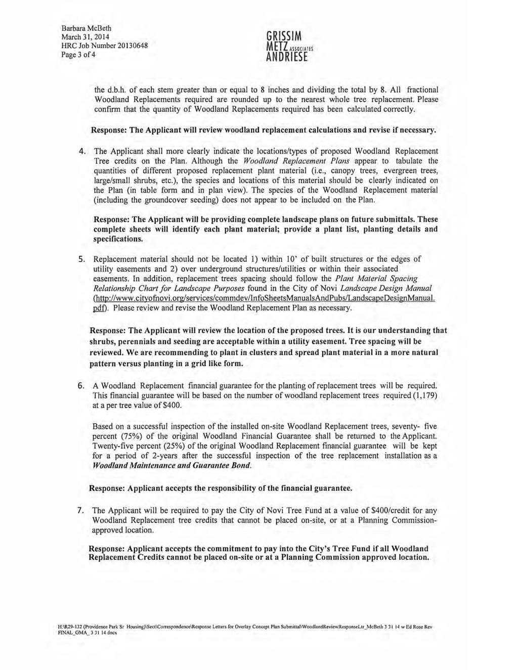
107
108
109
110
111
112
113
114
115
116 Community Impact Statement

117 COMMUNITY IMPACT STATEMENT ROSE SENIOR LIVING AT PROVIDENCE PARK NOVI, MICHIGAN Edward Rose and Sons February 18, 2014
118 TABLE OF CONTENTS 1. Impact on Police and Fire Services Page 1 2. Employment Opportunities Page 1 3. Tax Revenues Page 1 4. Utility Connections Page 1 5. Surrounding Land Uses Page 1 & 2 6. City Performance Standards Page 2 7. Proposed Land Use Page 2 8. Social Impacts Page 2 & 3 9. Environmental Factors Page 3 & Social Impacts Page Traffic Impacts Page Proposed Site Amenities (I.E. Sidewalks, Public Parks, Page 5 Bicycle Paths Etc.)
119 1. Impact on Police and Fire Services As with any new development additional service areas of police and fire protection will be necessary. With proper planning and prevention i.e; interior building sprinklers, building security systems, on-site fire-hydrants, fire rated building materials and adequate water pressure, the demand for these services can be minimized. It is anticipated that the new development will support its fair share of these service costs through increases in property taxes. 2. Employment Opportunities It is projected that 150 jobs will be created during the construction of the building and site improvements. Once the construction of the building is complete it will employ approximately 80 full and 20 part-time persons. 3. Tax Revenues Rose Senior Living will generate in the range of $625, ,000 in property taxes based on the current city millage of $ /1000 value of S.E.V. of $12.5 million. 4. Utility Connections Based on the City of Novi s water unit factor list, it was determined that the proposed development will generate 62 residential equivalency units, which equates to an average of 0.25 cfs and a peak flow of 1.0 cfs. The estimated connection fee s for water and sanitary sewer at $4.570/tap unit is $283, Water pressures in this area range from 35 to 75 psi according to modeling by the City. Uses Number of Beds Use Factors REU's Convalescent/Nursing Home REU/Bed Surrounding Land Uses Adjacent Land Uses to Rose Senior Living at Providence Park Existing Land Use Future Land Use** North Hospital and Medical Offices Hospital - OCS East Multiple Family and Single Family Multiple Family South Recreation Preserve and Single Family Single Family and Educational Facility West Nursing Home/Suburban low rise Suburban Low Rise **Master Plan for Land Use adopted by August 25, Page 1 of 5 Community Impact Statement Rose Senior Living at Providence Park
120 As shown above, the site is bounded by the following existing land uses: St. John/Providence Hospital Medical Campus to the north, single family and recreation preserve to the south and a combination of suburban low-rise and multiple family uses to the east and west. The uses that are planned at Rose Senior Living at Providence Park are compatible with existing and potential future surrounding land uses. The proposed development is consistent with the suburban low-rise office land use designations provided in the Master Plan for Land Use. The proposed three story building with a single family residential character meet the intent of the Planned Suburban Low-Rise zoning overlay district. 6. City Performance Standards The proposed development will meet or exceed all city performance standards, Noise and pollution levels, generated by automobiles and truck traffic at the site, will be equivalent to residential low-rise uses in compliance with Section The impact of these elements will be mitigated to some degree by the placement of building and internal and peripheral tree plantings. There is no anticipated negative impact upon adjacent properties due to noise or emissions from the proposed development. 7. Proposed Land Use The acre site is at the northwest corner of 11 Mile Road and Beck Road, in Section 17, Novi Michigan. Presently the site is vacant. Please see Exhibit A, Proposed Use. The proposed 182 unit senior living development will provide various levels of care and will enhance the significant natural features and provide open space for water management and wetland mitigation. The proposed unit mix includes 69 congregate care/independent living units, 75 assisted living units, and 38 memory care units. The proposed uses are consistent with the existing zoning of the subject site. The site was recently overlaid with a suburban low-rose zoning over the existing R-3 zoning. As noted above the proposed uses are consistent with the Future Land Use Plan for west Novi. Due to the nature of the proposed development, the character of the existing site will be significantly altered. The once wooded character of the site will be developed by the Senior Living building and supporting parking areas. It is the intent of this proposal that the anticipated negative impacts by the proposed development will be mitigated by; innovative site design and layout, properly designed landscaping and buffering and sculptured grading. 8. Social Impacts A. Existing Users/Uses: Since the site is vacant so no residents, merchants or business owners will be displaced by the proposed development. Page 2 of 5 Community Impact Statement Rose Senior Living at Providence Park
121 B. Traffic Impact: A separate letter provides a trip generation analysis and shows that a traffic impact study is not required. C. Large portions of the Providence Campus have been placed under wetland and woodland conservation easements. This area will flourish with animal and plant life. The preservation area will continue to be an essential component of the water management system planned for the proposed development and the Providence Medical Campus site. The development will be linked internally with the sidewalks and crosswalks. A bike path is planned along the north side of the development to connect the residential neighborhoods to the hospital and schools. D. Population Projections: The development expects to employ approximately 80 full time and 20 part time people, who may currently reside within the Novi area. There will be little change in demand upon school or City recreational facilities except those individuals that relocate due to employment opportunities. 9. Environmental Factors A. Existing natural site features: The proposed site layout preserves mixed wetland, woodland, and flood plain on the property. See the Woodland and Wetland response letter attached for additional information. B. Water Management Plan Impacts The subject parcel, here in referred to as the Rose Senior Living (RSL) at Providence Park lies within the Novi-Lyon watershed. Immediately north of the subject development lies the Providence Hospital Novi Campus, which serves as the headwaters of the Shaw Creek in the City of Novi, Oakland County, Michigan. The property is located within the southeast corner of Section 17, Township 1 North, Range 8 East. The majority of the Development naturally drains to the south and west and into the Huron River Basin. C. Natural features that will be removed: The proposed site layout would remove a total of 1.36 acres of forested wetland, as well as 0.07 acres of emergent scrub-shrub wetlands, for a total of 1.43 acres. D. Storage of Hazardous or Toxic Materials: The proposed uses will not manufacture, use or store any hazardous or toxic materials on the site. E. Proposed Underground Storage Tanks: A new underground unleaded diesel fuel storage tank is planned for the stand by emergency generator. The tank is an integral part of the generator, as it is a double walled belly tank that the generator mounts to. The location of the tank on site is planned on the north side of the building near the service drive. Page 3 of 5 Community Impact Statement Rose Senior Living at Providence Park
122 The new belly storage tanks will be constructed according to current regulations; Part 211 of Michigan Act 451 (1994), as amended. The design features of the new tanks will include: 1) Tank leak detection 2) Spill/overfill protection 3) Cathodic protection (if required) 4) Double-wall distributing piping F. Environmental History: A Phase I Environmental Site Assessment was prepared by SME in January, 2014 for the subject site. The Phase I ESA Study was performed in general accordance with the scope and limitations of the American Society for Testing and Materials Practice E This assessment revealed no evidence of recognized environmental conditions in connection with the property. G. Impact on Wildlife: Stream systems such as the tributary to the Novi-Lyon Drain and it associates wetlands would typically support wildlife such as turtles and frogs, as well as aquatic reptile and invertebrate species. It should be noted, however that the quality of this system is low and that portions of it likely dry out during the summer months. The field areas, with its scattered trees and scrub/shrub pockets, would normally provide habitat for common mammals tolerant of urban conditions. These would typically include squirrel, raccoon, skunk, opossum, white tailed deer, cotton tailed rabbit, ground hog, and fox. Common avian species, including songbirds and raptors, would also be expected to utilize this type of habitat. Wildlife with the development will be displaced to other similar natural and disturbed habitats in the vicinity. Some wildlife may take refuge in the preservation area located on the west side of the property. This area contains a mix of open water wetland, emergent wetland, forested upland, and upland field, and would typically support the wildlife species listed above. 10. Social Impacts A. Relocation of existing uses or occupants. The proposed project does not require the relocation of any residential, commercial, or other uses. The entire development area is currently vacant land. 11. Traffic Impacts The proposed development does not adversely impact the adjacent roadways as in a response letter to the City s Traffic Engineering Consultants that included a trip generation analysis and found that traffic impact study was not required. Page 4 of 5 Community Impact Statement Rose Senior Living at Providence Park
123 12. Proposed Site Amenities (I.E. Sidewalks, Public Parks, Bicycle Paths, Etc.) The proposed project has added sidewalk along the connecting roads to Providence Parkway and Beck Road for pedestrian use. An area has been contemplated for the installation of the City s off-road/neighborhood pathway as set forth in the Non-Motorized Master Plan Dated February 28, The development is also incorporating trees, shrubs, plazas, recreational areas and plantings along the City s safety path to enhance the user s experience while traveling the Providence Campus. Provisions have also been made for bicycle parking at the Rose Senior Living development for residents, employees and visitors to use an alternative means of access. Page 5 of 5 Community Impact Statement Rose Senior Living at Providence Park
124 Applicant Requested Deviations
125
126
127

128
129
130
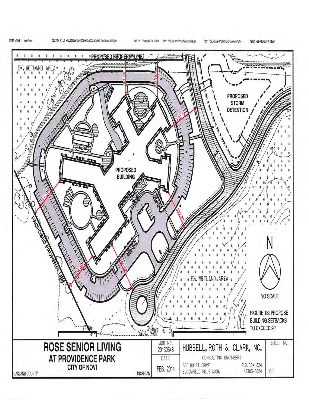
131
132
133
134
135
136
137
138

139
140
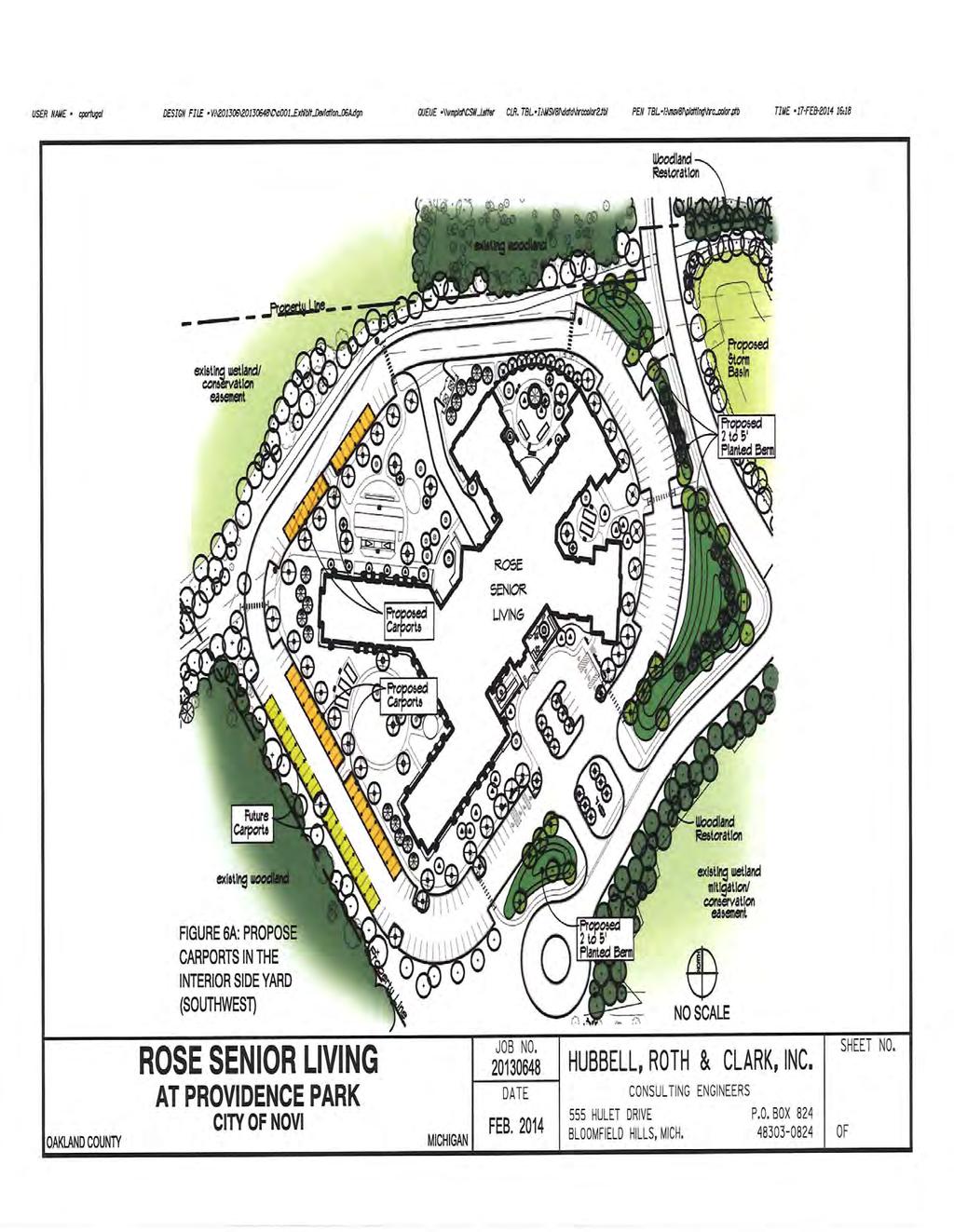
141
142
143
144
145
146
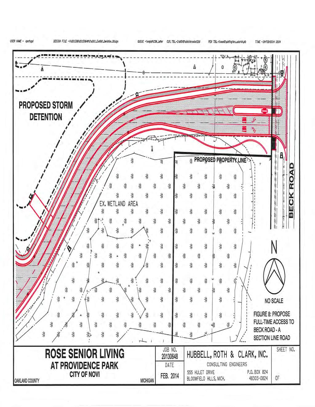
147
148
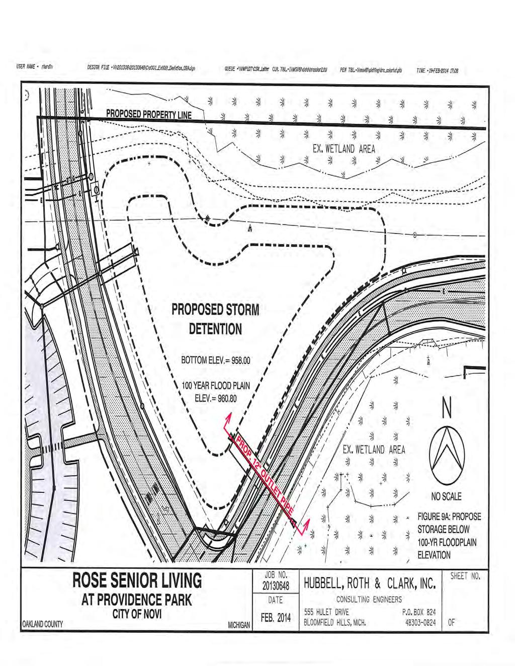
149
150
151
152
153
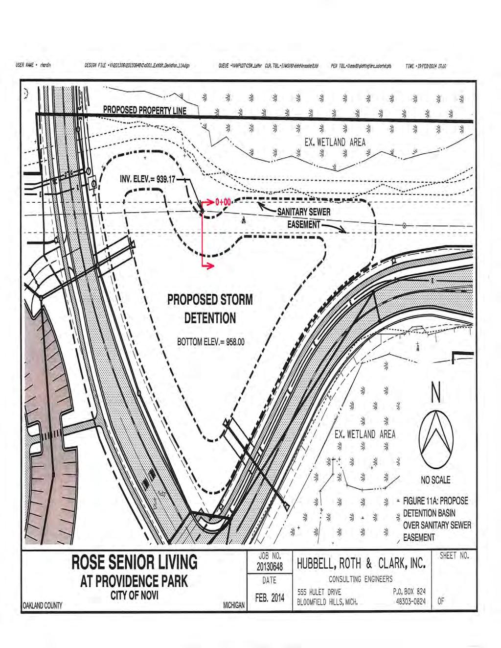
154
155
156
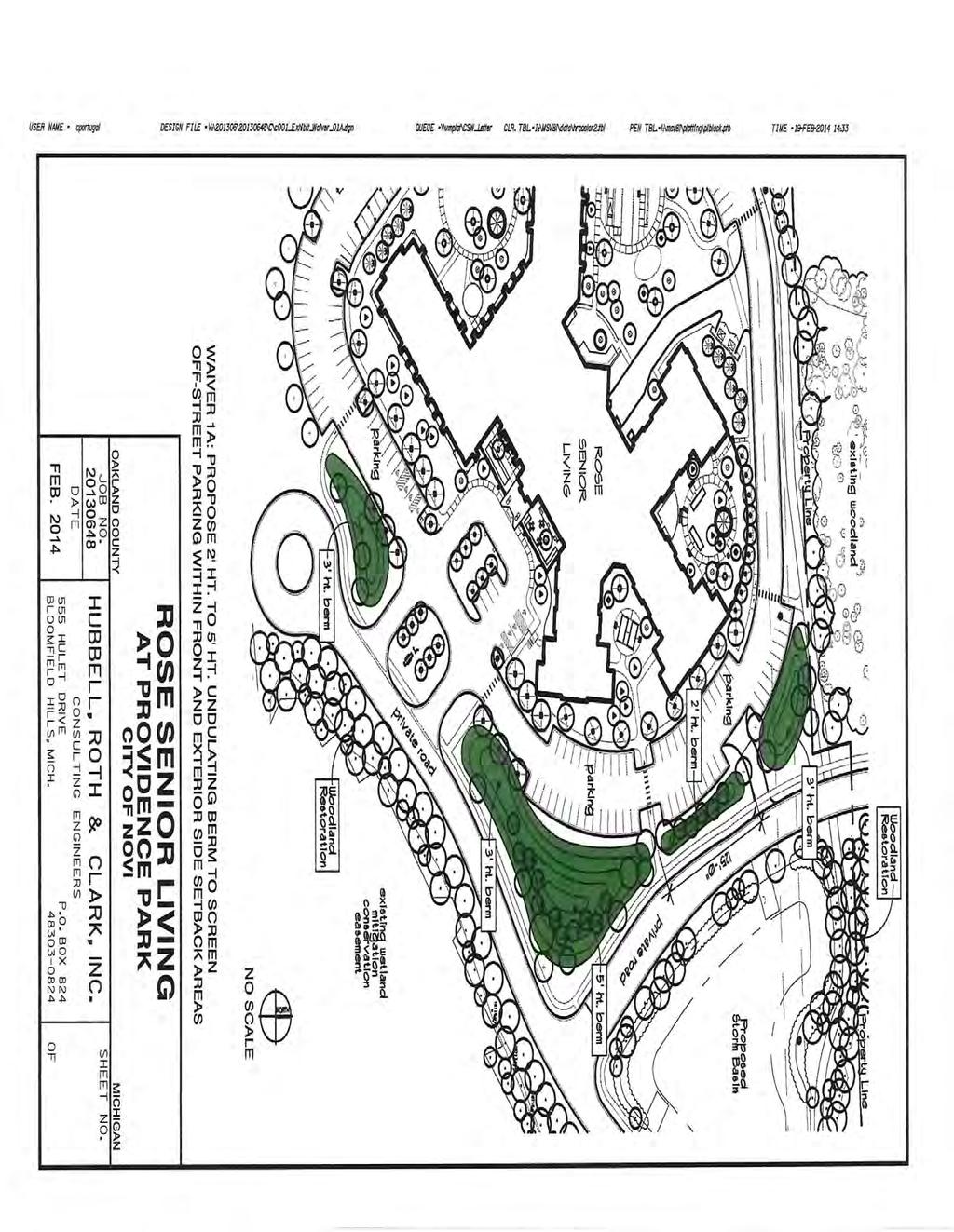
157
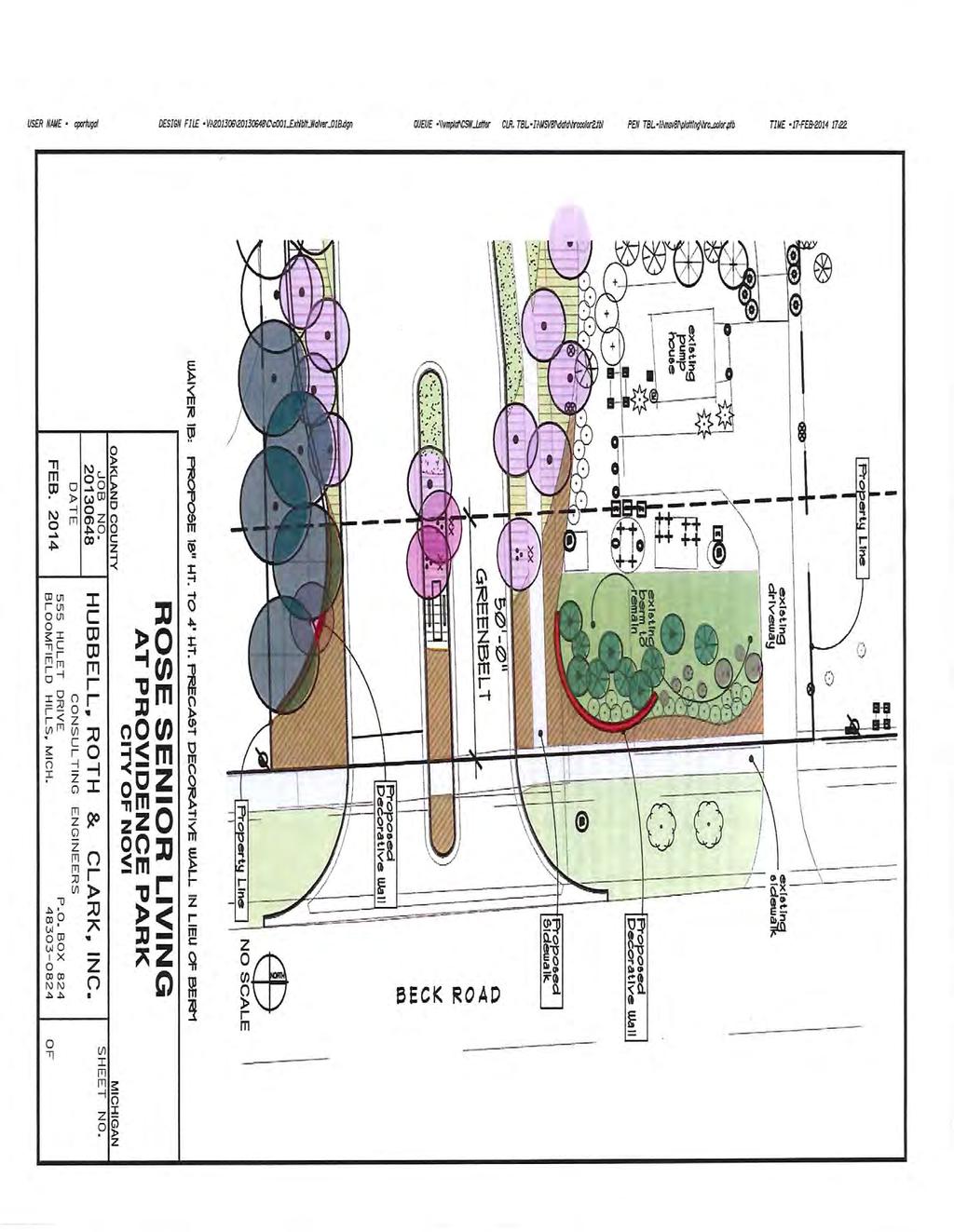
158
159

160
161
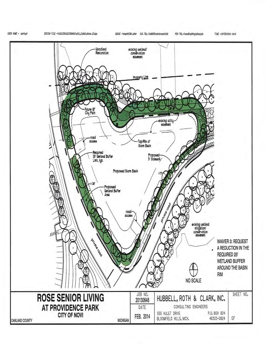
162
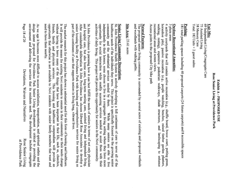
163
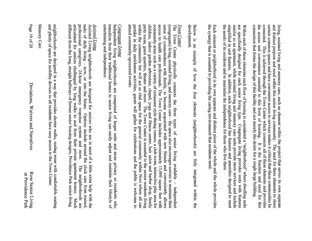
164
ADAMS NORTH TECHNOLOGY CENTER JSP 17-40
 ADAMS NORTH TECHNOLOGY CENTER JSP17-40 ADAMS NORTH TECHNOLOGY CENTER JSP 17-40 Consideration of the request of Northern Equities Group for Preliminary Site Plan and Stormwater Management Plan approval.
DETROIT CATHOLIC CENTRAL PARKING EXPANSION JSP 14-12
 DETROIT CATHOLIC CENTRAL PARKING EXPANSION JSP 14-12 Detroit Catholic Central Parking Expansion JSP14-12 Public hearing at the request of Catholic Central High School for approval of the Preliminary Site
Berkshire Pointe JSP13-47
 Berkshire Pointe JSP13-47 Berkshire Pointe JSP13-47 Public hearing at the request of Ivanhoe Companies for Preliminary Site Plan, Wetland Permit, Woodland Permit and Stormwater Management Plan approval.
Application for Site Plan Review
 Application for Site Plan Review City of Pontiac Office of Land Use and Strategic Planning 47450 Woodward Ave, Pontiac, MI 48342 T: 248.758.2800 F: 248.758.2827 Property/Project Address: Sidwell Number:
PLANNED UNIT DEVELOPMENT & SUBDIVISION STAFF REPORT Date: May 18, 2017
 & PUD-0000102-2017 PLANNED UNIT DEVELOPMENT & SUBDIVISION STAFF REPORT Date: May 18, 2017 NAME SUBDIVISION NAME Dauphin Creek Estates Subdivision Dauphin Creek Estates Subdivision LOCATION CITY COUNCIL
CITY OF ZEELAND PLANNING COMMISSION
 APPLICATION FOR SITE PLAN REVIEW AND SPECIAL LAND USE Date City Official App. Filing Fee Rec'd ($350) NOTE TO APPLICANT: Please submit this application for Site Plan Review along with twenty (20) copies
ROLL CALL Member Anthony, Member Avdoulos, Member Greco, Member Lynch, Member Maday, Chair Pehrson
 CALL TO ORDER The meeting was called to order at 7:00 PM. PLANNING COMMISSION ACTION SUMMARY CITY OF NOVI Regular Meeting July 11, 2018 7:00 PM Council Chambers Novi Civic Center 45175 W. Ten Mile (248)
THE PRESERVE AT ISLAND LAKE (PHASE 8) JSP13-69
 JSP13-69") THE PRESERVE AT ISLAND LAKE (PHASE 8) JSP13-69 THE PRESERVE AT ISLAND LAKE (PHASE 8) JSP13-69 Public hearing at the request of Toll Brothers, Inc. for recommendation to City Council for approval to include
THE PRESERVE AT ISLAND LAKE (PHASE 8) JSP13-69 THE PRESERVE AT ISLAND LAKE (PHASE 8) JSP13-69 Public hearing at the request of Toll Brothers, Inc. for recommendation to City Council for approval to include
Neptune Center JSP14-10
 Neptune Center JSP14-10 Neptune Center, JSP14-10 Approval of the request of Dorchen/Martin Associates, nc. for Neptune Center for same side and opposite side driveway spacing waivers. The subject property
D1 September 11, 2013 Public Hearing APPLICANT:
 D1 September 11, 2013 Public Hearing APPLICANT: BEACH MUNICIPAL FEDERAL CREDIT UNION PROPERTY OWNER: SISTERS II, LLC STAFF PLANNER: Karen Prochilo REQUEST: Conditional Change of Zoning (AG-2 Agriculture
Oberlin JSP Required Action Approval/denial of the revised Preliminary Site Plan and revised Woodland Permit
 Oberlin JSP14-42 Oberlin JSP14-42 Public hearing request of Singh Development for Revised Preliminary Site Plan utilizing the Open Space Preservation Option and Revised Woodland Permit approval. The subject
12 January 12, 2011 Public Hearing APPLICANT: TAILWIND DEVELOPMENT GROUP,LLC PROPERTY OWNER: CITY OF VIRGINIA BEACH
 12 January 12, 2011 Public Hearing APPLICANT: TAILWIND DEVELOPMENT GROUP,LLC PROPERTY OWNER: CITY OF VIRGINIA BEACH STAFF PLANNER: Faith Christie REQUEST: Conditional Change of Zoning (from PD-H1 Planned
Asbury Chapel Subdivision Sketch Plan
 Asbury Chapel Subdivision Sketch Plan PART 1: PROJECT SUMMARY Applicant: NVR Inc. Project Size: +/- 76.13 acres Parcel Numbers: 02101112,02116101,02116112, 02116113 Current Zoning: Transitional Residential
PLAN REVIEW CENTER REPORT December 5, Planning Review Panera Bread Drive-through JSP Revised Preliminary Site Plan
 ,(IIY(ll- ~0 PLAN REVIEW CENTER REPORT December 5, 2012 Planning Review Panera Bread Drive-through \( ~ JSP12 48 Il",jUI/. "CY" '; n"il I... Petitioner Panera Bread. LLC Review Type Revised Preliminary
Outdoor Accents JC14-120
 Outdoor Accents JC14-120 Outdoor Accents, JC14-120 Consideration of the request of Outdoor Accents, Inc. for Preliminary Site Plan and Section 9 Façade Waiver approval. The applicant is proposing to occupy
November 21, Planning Commission Charter Township of Lyon Grand River Ave. New Hudson, MI 48165
 Planning Commission Charter Township of Lyon 58000 Grand River Ave. New Hudson, MI 48165 Subject: AP-18-68; 11 Mile and Milford Road Park, Site Plan Review #1 Based on site plan dated 11/12/18 Location:
Planning Commission Staff Report June 5, 2008
 Owner/Applicant Taylor Village Sacramento Investments Partners, LP c/o Kim Whitney 1792 Tribute Road #270 Sacramento, CA 95815 Staff Recommendation Planning Commission Staff Report Project: File: Request:
SUBDIVISION, PLANNED UNIT DEVELOPMENT, PLANNING APPROVAL, REZONING & SIDEWALK WAIVER STAFF REPORT Date: February 7, 2013
 SUBDIVISION, PLANNED UNIT DEVELOPMENT, PLANNING APPROVAL, REZONING & SIDEWALK WAIVER STAFF REPORT Date: February 7, 2013 APPLICANT NAME SUBDIVISION NAME DEVELOPMENT NAME LOCATION S. E. Cemeteries of AL
AMERICAN INTERIORS JSP16-55
 AMERICAN INTERIORS JSP16-55 AMERICAN INTERIORS JSP16-55 Consideration at the request of American Interiors, for approval of Preliminary Site Plan, landbank parking and Storm water Management Plan. The
REQUEST Current Zoning: O-15(CD) (office) Proposed Zoning: TOD-M(CD) (transit oriented development mixed-use, conditional)
 (office) Proposed Zoning: TOD-M(CD) (transit oriented development mixed-use, conditional)") Rezoning Petition 2016-117 Zoning Committee Recommendation January 4, 2017 REQUEST Current Zoning: O-15(CD) (office) Proposed Zoning: TOD-M(CD) (transit oriented development mixed-use, conditional) LOCATION
Rezoning Petition 2016-117 Zoning Committee Recommendation January 4, 2017 REQUEST Current Zoning: O-15(CD) (office) Proposed Zoning: TOD-M(CD) (transit oriented development mixed-use, conditional) LOCATION
PLANNED UNIT DEVELOPMENT Date: April 5, 2018
 PLANNED UNIT DEVELOPMENT Date: April 5, 2018 DEVELOPMENT NAME SUBDIVISION NAME LOCATION Robert Myers Robert Myers 2955 and 2989 Dauphin Street (Southeast corner of Dauphin Street and Sage Avenue) CITY
R E S O L U T I O N. Single-Family Residence/ Church. 2,488 sq. ft. 2,488 sq. ft. Area Parking Required: Church
 R E S O L U T I O N WHEREAS, the Prince George s County Planning Board is charged with the approval of Detailed Site Plans pursuant to Part 3, Division 9 of the Zoning Ordinance of the Prince George s
RAINBOW CHILD CARE JSP16-43
 RAINBOW CHILD CARE JSP16-43 RAINBOW DAY CARE JSP16-43 Consideration at the request of 814 Development LLC for approval of Preliminary Site Plan and Storm water Management Plan approval. The subject property
VILLAGE OF CLEMMONS PLANNING BOARD DRAFT STAFF REPORT. Single Family Residential, Townhomes
 VILLAGE OF CLEMMONS PLANNING BOARD DRAFT STAFF REPORT PETITION INFORMATION Docket # C-212 Staff Megan Ledbetter Petitioner(s) Peacehaven Development LLC Owner(s) Larry Jarvis, William Alexander and Peacehaven
PLANNED UNIT DEVELOPMENT & SUBDIVISION STAFF REPORT Date: March 15, 2012
 PLANNED UNIT DEVELOPMENT & SUBDIVISION STAFF REPORT Date: March 15, 2012 DEVELOPMENT NAME SUBDIVISION NAME LOCATION OSR Subdivision OSR Subdivision 5559 Old Shell Road (South side of Old Shell Road, 570
4 January 11, 2012 Public Hearing APPLICANT:
 . 4 January 11, 2012 Public Hearing APPLICANT: MID-ATLANTIC AUTO PROPERTY OWNER: DZR, LLC STAFF PLANNER: Leslie Bonilla REQUEST: Conditional Use Permit (truck rental, automobile service, and automotive/bulk
AUTONEUM JSP Required Action Approval or denial of Preliminary Site Plan and Stormwater Management Plan
 AUTONEUM JSP 14-80 AUTONEUM OFFICE AND RESEARCH & TRAINING BUILDING Public Hearing at the request of Dembs Development, Inc. to approve the Preliminary Site Plan and a Stormwater Management Plan for Autoneum.
Giacopetti, Lynch, Pehrson. 1. Roll Call. 2. Approval of Agenda. 3. Audience Participation and Correspondence. 4. Discussion Items
 MASTER PLAN AND ZONING COMMITTEE City of Novi Planning Commission August 17, 2016 at 6:00 p.m. Novi Civic Center Mayor s Conference Room 45175 W. Ten Mile, Novi, MI 48375 (248) 347-0475 AGENDA Members:
Note: Staff reports can be accessed at Special Permit Application No.
 The Maryland-National Capital Park and Planning Commission Prince George's County Planning Department Development Review Division 301-952-3530 Note: Staff reports can be accessed at www.mncppc.org/pgco/planning/plan.htm.
Ref: March 21, Ms. Jody Kablack Director of Planning and Community Development Town of Sudbury 278 Old Sudbury Road Sudbury, MA 01776
 35 New England Business Center Drive Suite 140 Andover, MA 01810-1066 Office: 978-474-8800 Fax: 978-688-6508 Web: www.rdva.com Ref: 7198 Director of Planning and Community Development Town of Sudbury 278
VILLAGE OF CLEMMONS PLANNING BOARD DRAFT STAFF REPORT
 VILLAGE OF CLEMMONS PLANNING BOARD DRAFT STAFF REPORT PETITION INFORMATION Docket # C-226 Staff Megan Ledbetter Petitioner(s) JBJH Properties, LLC Owner(s) JBJH Properties, LLC Subject Property 5892-49-1766
APPLICATION FOR REZONING PROPERTY CITY OF HOLLAND, MICHIGAN. Name of Applicant. Address, and Phone # of Applicant
 APPLICATION FOR REZONING PROPERTY CITY OF HOLLAND, MICHIGAN Name of Applicant Address, Email and Phone # of Applicant Name and Address of Owner (if other than applicant) Ownership Interest of Applicant
At Your Disposal CUP Amendment, Lot 20, Village Service Commercial, at 128 Bastille Dr. (PLN17-208)
") MEMORANDUM Archuleta County Development Services Planning Department 1122 HWY 84 P. O. Box 1507 Pagosa Springs, Colorado 81147 970-264-1390 Fax 970-264-3338 TO: Archuleta County Planning Commission FROM:
MEMORANDUM Archuleta County Development Services Planning Department 1122 HWY 84 P. O. Box 1507 Pagosa Springs, Colorado 81147 970-264-1390 Fax 970-264-3338 TO: Archuleta County Planning Commission FROM:
DEPARTMENT OF PLANNING JEFFERSON PARISH, LOUISIANA
 DEPARTMENT OF PLANNING JEFFERSON PARISH, LOUISIANA DESIGN REVIEW REPORT : CPZ-3-1 : (S) Cynthia Lee-Sheng AT LARGE: A Chris Roberts B Elton M. Lagasse ADVERTISING DATES: 06/03/1 06/10/1 06/17/1 PAB PUBLIC
14 October 10, 2012 Public Hearing APPLICANT: MPB, INC
 14 October 10, 2012 Public Hearing APPLICANT: MPB, INC PROPERTY OWNER: MUNDEN & ASSOCIATES, LP STAFF PLANNER: Karen Prochilo REQUEST: Conditional Change of Zoning (AG-1 & AG-2 to Conditional O-2) ADDRESS
2 January 13, 2010 Public Hearing APPLICANT: AUTOBELL CAR WASH, INC
 REQUEST: Conditional Use Permit (car wash) 2 January 13, 2010 Public Hearing APPLICANT: AUTOBELL CAR WASH, INC PROPERTY OWNER: MESSER 1060 INDEPENDENCE BOULEVARD STAFF PLANNER: Carolyn A.K. Smith ADDRESS
PLNPCM Carl s Jr. Commercial Parking Lot at Redwood Road and 1700 South
 Staff Report PLANNING DIVISION COMMUNITY & NEIGHBORHOODS To: Salt Lake City Planning Commission From: Casey Stewart; 801-535-6260 Date: November 4, 2016 Re: PLNPCM2015-00874 Carl s Jr. Commercial Parking
MIXED-USE VILLAGE OVERLAY FLOATING DISTRICT
 MIXED-USE VILLAGE OVERLAY FLOATING DISTRICT Zoning regulations developed by committee to the Planning Board for the Town of DeWitt, NY Issue date: 13 July 2017 revised 3/12/2018, revised 4/26/2018, 5/9/2018
F. Driveways. Driveways which provide access to off-street parking or loading from public streets shall comply with the following:
 Section 20.945.040 General Design Standards for Surface Parking Areas. A. Review Authority. Parking lot design and drainage shall be subject to review and approval of the City Transportation Manager. B.
VILLA D ESTE JSP17-52 with Rezoning
 VILLA D ESTE JSP17-52 with Rezoning 18.718 VILLA D ESTE JSP17-52 WITH REZONING 18.718 Public hearing at the request of Cambridge of Novi, LLC for Planning Commission s Recommendation to City Council for
PLANNED DEVELOPMENT (MASTER PLAN & UNIT PLAN)
") Central Permit Center 555 Santa Clara Street Vallejo CA 94590 Business License Building Fire Prevention Planning Public Works 707.648.4310 707.648.4374 707.648.4565 707.648.4326 707.651.7151 PLANNED DEVELOPMENT
Central Permit Center 555 Santa Clara Street Vallejo CA 94590 Business License Building Fire Prevention Planning Public Works 707.648.4310 707.648.4374 707.648.4565 707.648.4326 707.651.7151 PLANNED DEVELOPMENT
PLANNED UNIT DEVELOPMENT STAFF REPORT Date: June 2, 2016
 # 9 ZON2016-01032 PLANNED UNIT DEVELOPMENT STAFF REPORT Date: June 2, 2016 DEVELOPMENT NAME JJT Properties LLC LOCATION 1147 & 1151 East I-65 Service Road South and 1180 Sledge Drive (Southeast corner
EXHIBIT A. Chapter 2.7 SPECIAL PLANNED DISTRICTS. Article XVIII 15th Street School Master Planned Development
 EXHIBIT A Chapter 2.7 SPECIAL PLANNED DISTRICTS Article XVIII 15th Street School Master Planned Development Sections: 2.7.3600 15 th Street School Master Planned Development 2.7.3610 Purpose 2.7.3620 Definitions
PLANNED UNIT DEVELOPMENT APPLICATION
 PLANNED UNIT DEVELOPMENT APPLICATION CITY OF THE DALLES Community Development Department 313 Court Street The Dalles, OR 97058 (541) 296-5481, ext. 1125 Fax (541) 298-5490 www.ci.the-dalles.or.us Date
Drexel, Barrell & Co.
 Drexel, Barrell & Co. June 18, 2018 Engineers/Surveyors Boulder Colorado Springs Greeley 3 South 7 th Street Colorado Springs, Colorado 80905-1501 719 260-0887 719 260-8352 Fax El Paso County Planning
Project phasing plan (if applicable) 12 copies of site plan
 12 copies of site plan") SITE PLAN REVIEW PERMIT APPLICATION City of Grand Haven, 11 N. Sixth Street, Grand Haven, MI 49417 Phone: (616) 847-3490 Fax: (616) 844-2051 Website: www.grandhaven.org 1. Project Information Address/location
SITE PLAN REVIEW PERMIT APPLICATION City of Grand Haven, 11 N. Sixth Street, Grand Haven, MI 49417 Phone: (616) 847-3490 Fax: (616) 844-2051 Website: www.grandhaven.org 1. Project Information Address/location
Drexel, Barrell & Co.
 Drexel, Barrell & Co. December 21, 2018 Engineers/Surveyors Boulder Colorado Springs Greeley 3 South 7 th Street Colorado Springs, Colorado 80905-1501 719 260-0887 719 260-8352 Fax El Paso County Planning
CASE NUMBER: 16SN0701 APPLICANT: Hanky, LLC
 STAFF S ANALYSIS AND RECOMMENDATION Planning Commission (CPC) Public Hearing Date: MAY 17, 2016 CPC Time Remaining: 100 DAYS Applicant s Agent: DANIEL L. CASKIE (804-569-7060) Applicant s Contact: MICHAEL
Rezoning Transportation Analysis Petition Number: General Location Identifier: , ,
 From: Kelsie Anderson, PE Kelsie.Anderson@charlottenc.gov 704-432-5492 Staff Reviewer: Rick Grochoske, PE rgrochoske@charlottenc.gov 704-432-1556 CDOT s review of this rezoning petition is intended to
Glenborough at Easton Land Use Master Plan
 Implementation 114 9.0 IMPLEMENTATION 9.1 OVERVIEW This chapter summarizes the administrative procedures necessary to implement the proposed land use plan, infrastructure improvements, development standards,
PARISH OF ASCENSION OFFICE OF PLANNING AND DEVELOPMENT PLANNING DEPARTMENT. Joint Planning and Zoning Meeting
 1. Call To Order 2. Roll Call of Members 3. Chairman's Comments PARISH OF ASCENSION OFFICE OF PLANNING AND DEVELOPMENT PLANNING DEPARTMENT Joint Planning and Zoning Meeting January 11, 2017 6:00 PM Courthouse
Major Subdivision Sketch Plan Checklist
 This checklist provides specific requirements that are apart of the Sketch process. The entire process is described by the Huntersville Subdivision Review Process which details all the submittal and resubmittal
The petition proposes the development of five townhomes on a vacant parcel between Charlotte Latin School and Providence Presbyterian Church.
 Rezoning Petition 2017-202 Final Staff Analysis June 18, 2018 REQUEST LOCATION Current Zoning: R-3 (single family residential) Proposed Zoning: UR-2(CD) (urban residential, conditional) with five-year
Chapter Master Planned Communities (MPC) District
 District") Sections 14.53.010 Purpose and Intent 14.53.020 Applicability 14.53.030 Procedure 14.53.040 MPC Standards 14.53.050 Required Findings 14.53.010 Purpose and Intent Chapter 14.53 Master Planned Communities
Sections 14.53.010 Purpose and Intent 14.53.020 Applicability 14.53.030 Procedure 14.53.040 MPC Standards 14.53.050 Required Findings 14.53.010 Purpose and Intent Chapter 14.53 Master Planned Communities
SITE PLAN SUBMISSION AND APPROVAL GUIDELINES
 SITE PLAN SUBMISSION AND APPROVAL GUIDELINES May, 2004 (last updated Jan 2019) 808 2 nd Avenue East Owen Sound, ON N4K 2H4 (519) 376-1440 TABLE OF CONTENTS SITE PLAN APPROVAL... 1 Mandate and Benefits
ORDINANCE WHEREAS, this Ordinance is consistent with the City of Winter Garden Comprehensive Plan; and
 ORDINANCE 17-06 AN ORDINANCE OF THE CITY COMMISSION OF THE CITY OF WINTER GARDEN, FLORIDA, CREATING ARTICLE XIV OF CHAPTER 118 OF THE CITY OF WINTER GARDEN CODE OF ORDINANCES PROVIDING FOR THE EAST PLANT
Staff Report CONDITIONAL USE
 Staff Report PLANNING DIVISION COMMUNITY & ECONOMIC DEVELOPMENT To: From: Salt Lake City Planning Commission Daniel Echeverria, (801) 535-7165, daniel.echeverria@slcgov.com Date: May 21, 2015 Re: PLNPCM2015-00139
CITY OF KEIZER MASTER PLAN APPLICATION & INFORMATION SHEET
 CITY OF KEIZER MASTER PLAN APPLICATION & INFORMATION SHEET PRE-APPLICATION CONFERENCE Prior to the actual filing of a Master Plan application, it is strongly recommended that the applicant contact Planning
Request Conditional Rezoning (R-15 Residential to Conditional A-24 Apartment) Staff Recommendation Approval. Staff Planner Jimmy McNamara
 Staff Recommendation Approval. Staff Planner Jimmy McNamara") Applicant Franklin Johnston Group Management & Development, LLC Property Owner Virginia Wesleyan College Public Hearing July 12, 2017 City Council Election District Bayside Agenda Item 3 Request Conditional
Applicant Franklin Johnston Group Management & Development, LLC Property Owner Virginia Wesleyan College Public Hearing July 12, 2017 City Council Election District Bayside Agenda Item 3 Request Conditional
McDonald s Restaurant - Purcellville Town of Purcellville Special Use Permit Statement of Justification July 24, 2014
 Introduction / Written Statement McDonald s Restaurant - Purcellville McDonald s Corporation is proposing to redevelop the existing McDonald s eating establishment with a drive-through located at 121 N
Petitioner Siegal Tuomaala Assoc. PropertY Characteristics Site Location: Site Zoning: Adjoining Zoning:
 PLAN REVIEW CENTER REPORT October 19, 2009 Planning Review Weiss Mixed Use Development Rezoning with Planned Rezoning Overlay SP# 09-26/Rezoning 18.690 Petitioner Siegal Tuomaala Assoc. Review Type Proposed
MONTGOMERY COUNTY PLANNING DEPARTMENT THE MARYLAND-NATIONAL CAPITAL PARK AND PLANNING COMMISSION
 MONTGOMERY COUNTY PLANNING DEPARTMENT THE MARYLAND-NATIONAL CAPITAL PARK AND PLANNING COMMISSION MCPB Item No. Date: 12-10-15 Leisure World Clubhouse II Addition Fitness Center, Limited Site Plan Amendment
ARTICLE 6: Special and Planned Development Districts
 ARTICLE 6: Special and Planned Development Districts 6-10 Traditional Neighborhood Development (TND) District 6-10.10 Purpose and Intent The Traditional Neighborhood Development (TND) District provides
THE CITY OF MOBILE, ALABAMA
 THE CITY OF MOBILE, ALABAMA LETTER OF DECISION Ark of Safety, Inc. Mobile, AL 36617 Re: (Northwest corner of Main Street and First Avenue, extending to the Southwest corner of Esau Avenue and Main Street.)
8 February 9, 2011 Public Hearing APPLICANT: 7-ELEVEN, INC.
 . 8 February 9, 2011 Public Hearing APPLICANT: REQUEST: Conditional Use Permit for an automobile service station with a convenience store ADDRESS / DESCRIPTION: 2448 Nimmo Parkway PROPERTY OWNER: COURTHOUSE
Request Change in Nonconformity. Staff Recommendation Approval. Staff Planner Jonathan Sanders
 Applicant & Owner Public Hearing April 11, 2018 City Council Election District Beach Agenda Item 5 Request Change in Nonconformity Staff Recommendation Approval Staff Planner Jonathan Sanders Location
PRELIMINARY CONDITIONAL USE SUBMITTAL CHECKLIST REQUIREMENTS
 This checklist must accompany your submittal as the cover page. CONDITIONAL USE Application Submittal Checklist for PRELIMINARY AND FINAL APPROVAL Per Winter Park Land Development Code Sec. 58-90 PRELIMINARY
PART 1: PROJECT SUMMARY. Proposed Land Use: 120 single-family lots. The application is Attachment A. The site plan is Attachment B.
 PART 1: PROJECT SUMMARY Applicant: JBH Development, LLC and Hopper Communities, INC Project Size: +/- 80.48 acres Parcel Number: 01513107, 01513108, 01513109, 01513113, 01513120, 01513121, 01513122, 01513124,
SITE PLAN REVIEW APPLICATION
 SITE PLAN REVIEW APPLICATION CITY OF THE DALLES Community Development Department 313 Court Street The Dalles, OR 97058 (541) 296-5481, ext. 1125 Fax (541) 298-5490 www.ci.the-dalles.or.us Date Filed File#
REZONING APPLICATION MPD SUPPLEMENT
 REZONING APPLICATION MPD SUPPLEMENT For Staff Use Only: DATE/TIMESTAMP: ZA# RECEIVED BY: The intent of the Master Planned District (MPD) designation is to allow flexibility in the design and construction
MEDWAY PLANNING BOARD MINOR SITE PLAN PROJECTS Application Guidelines
 Revised August 28, 2006 A. Procedure MEDWAY PLANNING BOARD MINOR SITE PLAN PROJECTS Application Guidelines 1) Before submitting a formal site plan application, prospective applicants are encouraged to
SUBMITTAL REQUIREMENTS
 WHEN PROCESS TYPE III IS USED References to Process Type III applications are found in several places in the Milton Municipal Code (MMC), indicating that the development, activity, or use, is permitted
MEMORANDUM. Planning and Zoning Division Department of Community Development TO: FROM: DATE: July 23, SUBJECT: PLNSUB : Salt City Plaza
 MEMORANDUM 451 South State Street, Room 406 Salt Lake City, Utah 84111 (801) 535-7757 Planning and Zoning Division Department of Community Development TO: FROM: Planning Commission Doug Dansie, Planning
SITE PLAN REVIEW APPLICATION AND CHECKLIST
 SITE PLAN REVIEW APPLICATION AND CHECKLIST PROJECT SUMMARY: Project Name: City/ETA Location: City ETA (Application fee & number of copies needed are based on location) Property Location (Legal Description
TOWNSHIP OF LOGAN SOIL & FILL IMPORTATION AND PLACEMENT APPLICATION SUBMITTAL CHECKLIST
 TOWNSHIP OF LOGAN SOIL & FILL IMPORTATION AND PLACEMENT APPLICATION SUBMITTAL CHECKLIST Applications: 5 copies of application - Applicant will reproduce the copies at his/her costs. The Township Clerk
5.1.1 The streetscape along US Highway 64 (Brevard Road); and, The built environment within new residential developments; and,
; and, The built environment within new residential developments; and,") Article 5. Landscaping 5.1 Purpose The Town of Laurel Park s landscape standards are designed to create a beautiful, aesthetically pleasing built environment that will complement and enhance community
Article 5. Landscaping 5.1 Purpose The Town of Laurel Park s landscape standards are designed to create a beautiful, aesthetically pleasing built environment that will complement and enhance community
CITY PLANNING COMMISSION AGENDA. ITEM NO(s): C.1 C.3 STAFF: STEVE TUCK
: C.1 C.3 STAFF: STEVE TUCK") Page 34 CITY PLANNING COMMISSION AGENDA ITEM NO(s): C.1 C.3 STAFF: STEVE TUCK FILE NOS: CPC ZC 12-00035 QUASI-JUDICIAL CPC NV 12-00036 QUASI-JUDICIAL AR DP 12-00039 QUASI-JUDICIAL PROJECT: APPLICANT: OWNER:
Page 34 CITY PLANNING COMMISSION AGENDA ITEM NO(s): C.1 C.3 STAFF: STEVE TUCK FILE NOS: CPC ZC 12-00035 QUASI-JUDICIAL CPC NV 12-00036 QUASI-JUDICIAL AR DP 12-00039 QUASI-JUDICIAL PROJECT: APPLICANT: OWNER:
Landscaping Standards
 CHAPTER 29 ARTICLE 403 29.403 Landscaping Standards Purpose: The purpose of this section is to protect and promote the public health, safety and general welfare by requiring landscaping in relation to
PRELIMINARY PLAT DESIGN REQUIREMENTS Updated 4/8/2016
 PRELIMINARY PLAT DESIGN REQUIREMENTS Updated 4/8/2016 The following items are required for the preliminary plat. Numbers correspond with those on the example preliminary plat. RENO COUNTY SUBDIVISION REQUIREMENTS
Urban Planning and Land Use
 Urban Planning and Land Use 701 North 7 th Street, Room 423 Phone: (913) 573-5750 Kansas City, Kansas 66101 Fax: (913) 573-5796 Email: planninginfo@wycokck.org www.wycokck.org/planning To: From: City Planning
M E M O R A N D U M. Principal Planner. HEARING DATE: March 13, 2018 CASE NUMBER: PC
 M E M O R A N D U M TO: FROM: PREPARED BY: Plan Commission Technical Review Committee Tim Semmann, AICP Principal Planner DATE DISTRIBUTED: March 6, 2018 HEARING DATE: March 13, 2018 CASE NUMBER: PC18-2561
Site Development Plan (SDP) Checklist
 Checklist") Development Services Department 100 N. Wilcox Street, Castle Rock CO 80104 303-660-1393 or CRGov.com Site Development Plan (SDP) Checklist A complete Site Development Plan (SDP) submittal will contain
Development Services Department 100 N. Wilcox Street, Castle Rock CO 80104 303-660-1393 or CRGov.com Site Development Plan (SDP) Checklist A complete Site Development Plan (SDP) submittal will contain
Project Name: MELWOOD HOTEL. Date Accepted: 1/12/04. Waived. Planning Board Action Limit: Plan Acreage: 1.7 Zone: Dwelling Units:
 The Maryland-National Capital Park and Planning Commission Prince George's County Planning Department Development Review Division 301-952-3530 Note: Staff reports can be accessed at www.mncppc.org/pgco/planning/plan.htm.
AWH REPORT OF THE PLANNING AND DEVELOPMENT DEPARTMENT FOR APPLICATION FOR REZONING ORDINANCE TO PLANNED UNIT DEVELOPMENT
 AWH REPORT OF THE PLANNING AND DEVELOPMENT DEPARTMENT FOR APPLICATION FOR REZONING ORDINANCE TO PLANNED UNIT DEVELOPMENT MAY 8, 2014 The Planning and Development Department hereby forwards to the Planning
Mayor Leon Skip Beeler and Members of the City Commission. Anthony Caravella, AICP, Director of Development Services
 CITY COMMISSION BRIEFING & Planning Board Report For Meeting Scheduled for June 7, 2012 Inner Room Cabaret Site Plan/Architectural Review Downtown Overlay District/Primary Downtown Area Site Plan Consent
CITY-COUNTY PLANNING BOARD DRAFT STAFF REPORT
 CITY-COUNTY PLANNING BOARD DRAFT STAFF REPORT PETITION INFORMATION Docket # W-3174 Staff Aaron King Petitioner(s) O Reilly Auto Parts Owner(s) Glenn Crossing Associates, LLC Subject Property Portion of
REQUEST FOR COUNCIL ACTION 6A AGENDA ITEM
 DATE REQUEST FOR COUNCIL ACTION 6A AGENDA ITEM ORIGINATING DEPT. AGENDA ITEM CITY ADMINISTRATOR APPROVAL Community Development PUD Concept & Development Stage Plan Preliminary Plat & Final Plat PREVIOUS
Prepared by: Casey Kempenaar, Senior Planner
 CITY OF CITRUS HEIGHTS PLANNING DIVISION STAFF REPORT PLANNING COMMISSION MEETING September 13, 2017 Prepared by: Casey Kempenaar, Senior Planner REQUEST The applicant requests a Design Review Permit Modification
The Maryland-National Capital Park and Planning Commission Prince George's County Planning Department Development Review Division
 The Maryland-National Capital Park and Planning Commission Prince George's County Planning Department Development Review Division 301-952-3530 Note: Staff reports can be accessed at www.mncppc.org/pgco/planning/plan.htm.
Staff Report. Conditional Use PLANNING DIVISION COMMUNITY & ECONOMIC DEVELOPMENT. Salt Lake City Planning Commission
 Staff Report PLANNING DIVISION COMMUNITY & ECONOMIC DEVELOPMENT To: From: Salt Lake City Planning Commission Maryann Pickering, Principal Planner (801) 535-7660 Date: December 10, 2014 Re: Church of Scientology
STAFF REPORT TO COUNCIL PLANNING AND DEVELOPMENT
 DATE: April 29, 2013 STAFF REPORT TO COUNCIL PLANNING AND DEVELOPMENT 1100 Patricia Boulevard, Prince George, B.C., V2L 3V9 TO: FROM: SUBJECT: MAYOR AND COUNCIL JESSE DILL, PLANNER Development Variance
Rezoning Petition Zoning Committee Recommendation August 1, 2017
 Rezoning Petition 2017-090 Zoning Committee Recommendation August 1, 2017 REQUEST LOCATION SUMMARY OF PETITION PROPERTY OWNER PETITIONER AGENT/REPRESENTATIVE COMMUNITY MEETING STATEMENT OF CONSISTENCY
ZONING AMENDMENT & PLANNED UNIT DEVELOPMENT STAFF REPORT Date: April 4, 2013
 ZONING AMENDMENT & PLANNED UNIT DEVELOPMENT STAFF REPORT Date: April 4, 2013 NAME DEVELOPMENT NAME LOCATION DIP Exchange, LLC DIP Exchange, LLC 93 Sidney Phillips Drive (West side of Sidney Phillips Drive,
Request Conditional Rezoning (R-10 Residential & I-1 Light Industrial to Conditional I-1 Light Industrial) Staff Recommendation Approval
 Staff Recommendation Approval") Applicant & Property Owner Public Hearing January 9, 2019 City Council Election District Beach Agenda Item 1 Request Conditional Rezoning (R-10 Residential & I-1 Light Industrial to Conditional I-1 Light
Applicant & Property Owner Public Hearing January 9, 2019 City Council Election District Beach Agenda Item 1 Request Conditional Rezoning (R-10 Residential & I-1 Light Industrial to Conditional I-1 Light
2 August 14, 2013 Public Hearing APPLICANT: CRESCENT COMMUNITY CENTER CORP. PROPERTY OWNER: S. L. ETHERIDGE, LLC
 2 August 14, 2013 Public Hearing APPLICANT: CRESCENT COMMUNITY CENTER CORP. PROPERTY OWNER: S. L. ETHERIDGE, LLC REQUEST: Conditional Use Permit (religious use) STAFF PLANNER: Karen Prochilo ADDRESS /
PLANNING JUSTIFICATION REPORT
 PLANNING JUSTIFICATION REPORT 55 DELHI STREET CITY OF GUELPH PREPARED FOR: VESTERRA PROPERTY MANAGEMENT PREPARED BY: LABRECHE PATTERSON & ASSOCIATES INC. SCOTT PATTERSON, BA, CPT, MCIP, RPP PRINCIPAL,
Watertown City Council
 City of Watertown Watertown City Council April 14 th, 2015 Agenda Item: City Comment on Sun Share CUP Application Request for Action: Motion to Approve City Comments regarding CUP Application Department:
Kingfisher Planned Development (PLNSUB ) and Special Exception (PLNPCM ) Planned Development and Special Exception
 and Special Exception (PLNPCM ) Planned Development and Special Exception") Staff Report PLANNING DIVISION COMMUNITY & ECONOMIC DEVELOPMENT To: From: Salt Lake City Planning Commission Maryann Pickering, Principal Planner (801) 535-7660 Date: October 22, 2014 Re: Kingfisher Planned
Staff Report PLANNING DIVISION COMMUNITY & ECONOMIC DEVELOPMENT To: From: Salt Lake City Planning Commission Maryann Pickering, Principal Planner (801) 535-7660 Date: October 22, 2014 Re: Kingfisher Planned
David J. Gellner, AICP, Principal Planner, , PLNSUB Harmons Brickyard Fuel Center Planned Development
 Staff Report PLANNING DIVISION COMMUNITY & NEIGHORHOOD DEVELOPMENT To: From: Salt Lake City Planning Commission David J. Gellner, AICP, Principal Planner, 801-535-6107, david.gellner@slcgov.com Date: January
Highway Oriented Commercial Development Criteria
 7.6 HOC-1 Highway Oriented Commercial District A. Statement of Purpose The Highway Oriented Commercial District (HOC-1) is intended to provide for the development of high density retail and service businesses