DRAFT Subject to Modifications
|
|
|
- April Harris
- 5 years ago
- Views:
Transcription
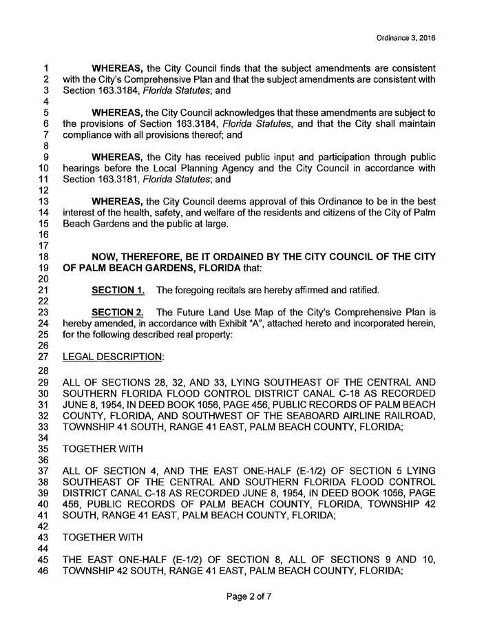
1 DRAFT Subject to Modifications TREASURE COAST REGIONAL PLANNING COUNCIL M E M O R A N D U M To: Council Members AGENDA ITEM 10 From: Date: Subject: Staff February 19, 2016 Council Meeting Local Government Comprehensive Plan Review Draft Amendment to the City of Palm Beach Gardens Comprehensive Plan Amendment No. 16-1ESR Introduction The Community Planning Act, Chapter 163, Florida Statutes, requires that the regional planning council review local government comprehensive plan amendments prior to their adoption. The regional planning council review and comments are limited to adverse effects on regional resources or facilities identified in the strategic regional policy plan (SRPP) and extrajurisdictional impacts that would be inconsistent with the comprehensive plan of any affected local government within the region. Council must provide any comments to the local government within 30 days of the receipt of the proposed amendments and must also send a copy of any comments to the state land planning agency. The amendment package from the City of Palm Beach Gardens contains a change to the Future Land Use Map and text changes to the Future Land Use Element of the comprehensive plan. This report includes a summary of the proposed amendment and Council comments. Summary of Proposed Amendment The proposed amendment is to change the future land use designation on 4,763 acres from Rural Residential (RR10) and Rural Residential (RR20) to Mixed Use Development (MXD), and to modify the location of the Urban Growth Boundary (UGB) to include this site. The subject property is the site of a proposed development known as Avenir. It is located on the north side of Northlake Boulevard, east of Grapeview Boulevard, west of Bay Hill Drive, and south of the Beeline Highway. Adjacent properties include the Acreage residential community to the south and southwest; former Mecca Farms property now owned by the South Florida Water Management District (SFWMD) to the west; Hungryland Slough Natural Area to the northwest; Caloosa residential community to the north; Sweetbay Natural Area and North Palm Beach County General Aviation Airport to the north, northeast and east; and Loxahatchee Slough Natural Area and Palm Beach Gardens Municipal Golf Course to the east. Also, there are significant vacant properties located adjacent to the Avenir site, including an approximate 100-
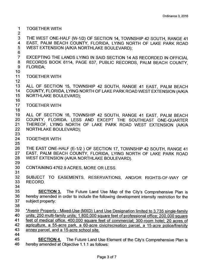
2 DRAFT Subject to Modifications acre rectangular site, known as the Spears Parcel, located about midway across the southern boundary of Avenir on the north side of Northlake Boulevard, and the Balsamo property located adjacent to the east side of the southeast corner of the Avenir property. The Avenir property is surrounded by land within unincorporated Palm Beach County, except for the boundaries adjacent to the Hungryland Slough Natural Area, Loxahatchee Slough Natural Area, and Palm Beach Gardens Municipal Golf Course. The area surrounding the subject site is generally lowdensity residential development and conservation areas. The proposed amendment also includes a development intensity restriction on the Future Land Use Map, which indicates the Avenir Property MXD land use designation is limited to 3,000 single-family units; 250 multi-family units; 1,940,000 square feet of professional office; 200,000 square feet of medical office; 400,000 square feet of commercial; 300-room hotel; 20 acres of agriculture, a 55-acre park, a 60-acre civic/recreation parcel, a 15-acre police/fire/city annex parcel, and a 15-acre school site. The attached ordinance specifies the land use designation is limited to 3,735 single-family units and 1,800,000 square feet of professional office, but a memorandum in the amendment package indicates that at a January 6, 2016 Palm Beach Gardens City Council meeting the Council approved a modification to the notation on the Future Land Use Map to reduce the total single family units from 3,735 to 3,000 units and to increase the professional office use from 1,800,000 to 1,940,000 square feet. Additionally, the proposed amendment includes text changes to Objective 1.1.1, Policies , (a).2, and (b) to modify the Urban Growth Boundary to include areas generally fronting Northlake Boulevard, east of the Hungryland Slough Natural Area, west of the Sweetbay Natural Area, and south of the Beeline Highway. The Avenir site is currently undeveloped with the majority of the property used for agriculture. The land covers include improved pasture with active cattle grazing, unimproved pasture, inactive row crops, and upland and wetland natural systems. Much of the central portion of the property has been impacted by drainage ditches and agricultural operations. Significant areas of upland and wetland natural systems exist in the extreme north, southwest and eastern portions of the property. Portions of the natural areas have been impacted by invasive exotic vegetation. The existing surface water management system consists of several drainage ditches that direct stormwater runoff to an existing outfall structure, which discharges to the C-18 Canal at the northwest portion of the property. Under the current Future Land Use designations of Rural Residential 10 and Rural Residential 20, a total of 405 dwelling units are permitted on the property. The applicant for the subject property is proposing the Avenir Planned Community Development (PCD), a phased 20-year project, which is proposing clustered development with an overall residential density of 0.68 dwelling units per acre. The 0.68 dwelling units per acre density is calculated by adding 3,000 single family units to 250 multifamily units and divided by 4,763 acres. The Avenir PCD Master Plan, which was not submitted as part of the amendment materials, includes 2,407 acres (50.5 percent) proposed for preservation and restoration of historic hydrologic and wildlife connections between regional conservation land and natural areas. The city staff report indicates the proposed project intends to cluster development in the southern 2
3 DRAFT Subject to Modifications portion of the property and provide the northern portion of the property for conservation, to be protected by a Conservation Preserve Lands Overlay on the City s official Zoning Map, platting the conservation lands, and providing a separate Conservation Easement to be recorded in the public records of Palm Beach County. The proposed surface water management system is a series of cascading basins within the developed area, which will discharge into two cascading basins within the preservation and restoration areas. The amendment package materials indicate the preservation and restoration area will be designed to increase the stage and duration of the site s natural hydroperiods to increase groundwater recharge, improve water quality, function as a wildlife corridor and trail system, and provide for improvement and protection of wildlife habitat. Stormwater runoff will be treated within the developed areas prior to discharge to the conservation area and will ultimately discharge to the C-18 Canal. The control elevation of the conservation area will be raised to restore the natural hydroperiod. A transportation analysis for the Avenir PCD indicates there are several transportation deficiencies in both the five-year short term and long-term analyses. In order to mitigate for the deficiencies, a program has been established, which includes land use strategies, roadway construction, transit improvements, and Transportation Demand Management (TDM) strategies. The city staff report indicates the Avenir PCD Master Plan proposes seven roadway connections on Northlake Boulevard and depicts the main spine roadway network. This roadway network includes sidewalks and bikeways along the internal roadway system to create a pedestrian and bike-friendly community. Also, the applicant is proposing a system of greenways and bicycle trails to link parks and open spaces to the conservation area. The city staff report indicates service availability letters have been issued for this project from the Solid Waste Authority of Palm Beach County, Seacoast Utilities, and the City of Palm Beach Gardens Police, Fire, and Recreation departments. The city report concludes that there will be no direct, adverse impacts on the adopted level of service standards for water, sewer, solid waste, recreation, police and fire services, and traffic. The city staff report also concludes that the proposed changes to the Future Land Use Map are compatible with the surrounding area based on the proposed low residential density of 0.68 dwelling units per acre, and the preservation and restoration of 2,407 acres of conservation area that will positively impact the region. Regional Impacts The City of Palm Beach Gardens has been reviewing recent proposals for development of the subject property since The city is aware of the environmental sensitivity and critical issues associated with this site. The Avenir property is strategically located and presents an opportunity to balance land uses, address long-time water management and regional environmental restoration issues, and correct certain limitations associated with existing development patterns, especially in the Central Western Communities of Palm Beach County. However, the environmental sensitivity and the relatively remote location of the site present a challenge on how to develop the site without adversely impacting regional resources and facilities and the quality of life of citizens in nearby communities and jurisdictions. 3
4 DRAFT Subject to Modifications The primary regional resources and facilities that could be impacted by the proposed amendment include: wetland and upland natural communities; the regional drainage system including the C- 18 Canal; the Loxahatchee River; adjacent and nearby conservation areas; the North Palm Beach County General Aviation Airport, and the regional roadway network. The potential impacts are discussed below followed by a discussion of urban design issues, which when implemented properly, have the potential to reduce impacts to regional resources and facilities. Environmental Impacts The city staff report refers to the applicant s environmental assessment, which indicates that approximately 1,993 acres of wetlands ranging in ecological quality have been identified on the property. Of these wetlands, 1,076 acres (53 percent) are proposed for preservation and 924 acres, which are mostly low quality wetlands, will be impacted for development. The wetlands proposed to be preserved on the site have been integrated into a flow-way system that allows for interconnection with adjacent publicly owned conservation areas. The protection of wetlands on the subject property is extremely important because the property is within the drainage basin of the Northwest Fork of the Loxahatchee River. A portion of the Northwest Fork is designated as a National Wild and Scenic River, because of its outstanding natural qualities. Historically, the drainage basin of the Northwest Fork of the Loxahatchee River was comprised primarily of natural systems, including pine flatwoods interspersed with cypress sloughs, hardwood swamps, marshes and wet prairies. At present, portions of the drainage basin have been drained or redirected to discharge into other water bodies. Furthermore, much of the developed land within the remaining basin has a drainage system designed to lower the water table and remove stormwater faster than under natural conditions. These changes to the drainage patterns have resulted in several problems, including excessively high flows in the river following rainfall events, and reduced base flows during the dry season. Reduced flows have allowed saltwater intrusion up the river channel, which has altered aquatic ecosystems and caused a change in the vegetation along the riverbanks. Correcting drainage problems, providing additional water storage, and protecting and conserving existing wetland systems that store water and contribute to the base flow of the river are extremely important for protecting and restoring the Loxahatchee River. The proposal to protect 2,407 acres on the Avenir property could be very beneficial for the Loxahatchee River, especially if the preservation and restoration area is designed to: 1) increase the stage and duration of the site s natural hydroperiods to increase groundwater recharge and improve water quality; and 2) work in concert with the adjacent Mecca Farms water management area being designed by the SFWMD. The conservation and restoration of 2,407 acres of the subject property is a cornerstone to the justification of allowing the increases in density and intensity. However, the main concerns with the proposal are that: 1) dedication of the conservation area was not defined on the Future Land Use Map along with all the other uses that are identified in the note at the bottom of the map; and 2) there are no plan policies specifically instructing restoration of the area. Council recommends: 1) the 2,407 acre area proposed to become a future conservation area be amended to a designation of Conservation rather than Mixed Use 4
5 DRAFT Subject to Modifications Development; and 2) plan policies be added outlining the main purposes of restoring the conservation area and a commitment to work with Palm Beach County and the SFWMD on the combined design and long-term management and operation of the Avenir and Mecca Farms restoration areas. Transportation Impacts The traffic study submitted with the amendment package indicates that for the five year analysis (2020), the project is expected to have an impact of 19,763 trips with 1,325 AM trips and 1,760 PM peak hour trips. The long range analysis (2040) indicates the net impact is an increase of 54,111 daily trips. The proposed amendment is expected to impact several components of the regional roadway network, which are considered significant regional resources and facilities. The traffic study indicates major roadway segments that will be impacted include: Coconut Boulevard from Orange Boulevard to Temple Boulevard and from Temple Boulevard to Northlake Boulevard Northlake Boulevard from Coconut Boulevard to Ibis Road and Ibis Road to State Road 7 Northlake Boulevard from State Road 7 to Beeline Highway Royal Palm Beach Boulevard from Persimmon Boulevard to 60 th Street and 60 th Street to Orange Boulevard 60 th Street from Royal Palm Beach Boulevard to State Road 7 Beeline Highway from Haverhill Road to Blue Heron Boulevard Blue Heron Boulevard from Military Trail to I-95 Northlake Boulevard from 140 th Avenue to Coconut Boulevard Northlake Boulevard from Jog Road to Military Trail Northlake Boulevard from Military Trail to I-95 Orange Boulevard from Coconut Boulevard to Royal Palm Beach Boulevard Persimmon Boulevard from Coconut Boulevard to Royal Palm Beach Boulevard The amendment package indicates the proposed project will use several alternative measures to mitigate the transportation impacts. The proposed mitigation program includes: 1. Dedication of 2,407 acres as conservation preserved lands 2. Limit maximum gross density to 0.68 dwelling units per acre and 3,250 maximum units 3. Provision of at least 250 residential units as affordable and/or workforce housing units 4. A phasing plan and/or conditions of approval requiring minimal commercial uses to be concurrent with residential units 5. Construction of a main north-south roadway (Avenir Connector) from Northlake Boulevard to the Beeline Highway in the early first phase of development 6. Construction of Northlake Boulevard from 140 th Avenue to State Road 7 from a 4-lane facility to a 6-lane facility in the early first phase of development 7. Coordination with the city and Palm Tran to bring transit to the project 8. Provision of bus stops and bus bays along Northlake Boulevard for a future transit route 9. Provision of a multi-modal center within a town center that includes a park and ride lot and a bike sharing facility 5
6 DRAFT Subject to Modifications 10. Provision of TDM policies that include ride sharing and compressed work week strategies for a workplace district Additionally, the project proposes to use a combination of capital improvements and proportionate share payments to mitigate impacts. Proportionate share is proposed for at least eight of the segments listed above. The proportionate share process is an alternative measure in which the maintaining agencies agree to accept payment for various projects and apply them to a series of specific improvements. The provision of the proposed capital improvements and proportionate share payments to mitigate the roadway impacts does not guarantee that regional roadways will operate at an acceptable level of service. In addition, a phasing plan that would require a balanced mix/ratio of housing and commercial uses has not been made part of the proposed amendment. This is one of the most valuable transportation mitigation tools that can be used to offset transportation impacts to the regional roadway network. Council recommends that, at a minimum, the amendment include a phasing plan balancing the timing and pace of residential and nonresidential construction through buildout of the project. Urban Design Issues The Mixed Use Development future land use category is intended to foster infill and redevelopment efforts, to deter urban sprawl and to encourage new affordable housing opportunities, as well as lessen the need for additional vehicular trips through the internalization of trips within a neighborhood or project. To create a functioning, multi-faceted type of development, mixed use development is dependent upon the successful integration of distinct uses. The proposed maximum gross residential density of 0.68 dwelling units per acre is inconsistent with these objectives. Such low densities do not support transit, do not promote compact, walkable communities, and appear to be inconsistent with the intent of the Mixed Use Development future land use. The applicant s analysis points to transit as a necessary element to mitigate the transportation impacts of this project. Council recommends that minimum net densities of the neighborhoods and districts be established by plan policy to meet minimum transit-supportive density standards. Council s SRPP Policy suggests minimum net residential densities for districts and neighborhoods to support transit be no less than eight units per acre. In addition, the city is encouraged to add a series of transit-supportive policies to its plan for this area that will positively influence the design of Avenir. Examples of such policies can be found in Council s SRPP, especially Policies through (Exhibit 11). Lastly, the amendment package from the city does not provide any graphics to illustrate the design intent of the project. Urban design comments and assessments must be inferred from the allocation of the land use program, proposed densities and intensities, and the project narrative. The project program, in number and types of residential units and non-residential square footages, is limited by the development intensity restriction provided in the city s Ordinance 3, However, there are no restrictions to number of acres of developable versus nondevelopable land. The ordinance is very specific to the precise number of units allowed, but is 6
7 DRAFT Subject to Modifications silent on the proposed dedication of 2,407 acres of conservation land. As noted above, the ordinance could be strengthened by specifying this fundamental component of the project. The identification of the conservation area is not only important for providing wildlife corridors and linkages between adjacent natural areas, but it is important to illustrate the boundaries of the areas to be developed. This is a critical issue in assuring the proposed plan of development will be built as represented and compatible with the current and future operations of the North Palm Beach County General Aviation Airport. Extrajurisdictional Impacts The proposed amendment was sent to the Palm Beach County Intergovernmental Plan Amendment Review Committee (IPARC) Clearinghouse Coordinator on November 23, The amendment package from the City of Palm Beach Gardens contains correspondence from the Town of Jupiter expressing concerns with the proposed Avenir Future Land Use Amendment regarding intensity and density cap and use conversion limitations. The town requested that in addition to a proposed rezoning application resolution, whereas clauses be included in the Future Land Use Map amendment ordinance to restrict use conversions to create additional residential units. Also, the town requested the Future Land Use amendment ordinance include a whereas clause requiring any proposed amendment to the intensity and density cap and use conversion restriction for the Avenir development go through the IPARC coordination process. In addition, the town expressed a concern about public beach and boat launch facility access impacts. The town requested that the city and the applicant coordinate with the Director of Park Development with the Palm Beach County Department of Parks and Recreation. The town indicated that any applicable county recreational impact fees generated by the proposed Avenir development should be allocated for development of Palm Beach County s proposed 164-acre Karen Marcus Ocean Park. On January 4, 2016, The City of West Palm Beach adopted Resolution opposing approval of the Avenir Future Land Use Map and text amendment by the City of Palm Beach Gardens. The attached resolution is opposed to the project for the following reasons: The proposed Avenir development is forecast to generate in excess of 5,700 peak hour trips and is expected to significantly impact over 50 roadway segments or intersections for which most of these are neither funded nor programmed for improvements that could accommodate the significant impacts of Avenir; The traffic generated by the development cannot be supported by existing roadways or roadways funded for construction; The identified needed improvements would significantly increase impervious areas, which could create significant additional runoff; In addition to other detrimental roadway segments proposed with the project, Palm Beach County s Traffic Performance Standards Review requires assured construction of State Road 7 from 60 th Street to Northlake Boulevard as a 4-lane divided facility, which is currently being challenged by the City of West Palm Beach due to its adverse impact on 7
8 DRAFT Subject to Modifications Grassy Waters Preserve s water quality, endangered species and their habitat, and the quality of life in the Western Communities; The proposed development and its traffic would significantly impact Grassy Waters Preserve; and The long established concept of greater density to the east and less density to the west is strongly supported by the City of West Palm Beach. Council recommends that prior to approval of the proposed amendment, the City of Palm Beach Gardens work with the Town of Jupiter and City of West Palm Beach to adequately address their concerns and identified extrajurisdictional impacts. Conclusion The City of Palm Beach Gardens is aware of the environmental sensitivity and critical issues associated with the Avenir property. This site is strategically located and presents an opportunity to balance land uses, address long-time water management and region environmental restoration issues in the area, and correct certain limitations associated with existing development patterns, especially in the Central Western Communities of Palm Beach County. However, the environmental sensitivity and the relatively remote location of the site present a challenge on how to develop the site without adversely impacting regional resources and facilities and the quality of life of citizens in nearby communities and jurisdictions. In order to achieve this goal, Council offers the following recommendations: 1. Include the 2,407 acre area proposed to become a future conservation area in the note on the Future Land Use Map and designate this area as Conservation land use rather than Mixed Use Development. The conservation of 2,407 acres of the subject property is a cornerstone to the justification of allowing the increases in density and intensity. 2. Establish plan policies clearly outlining the goals and objectives for restoration of the conservation area and a commitment to work with Palm Beach County and the SFWMD on the combined design and long-term management and operation of the Avenir and Mecca Farms restoration areas. 3. Include a phasing plan as part of the proposed amendment that would require construction of a balanced mix/ratio of housing and commercial uses through the build out of the project. This is one of the most valuable transportation mitigation tools that can be used to offset transportation impacts to the regional roadway network. 4. Establish minimum net densities for Avenir neighborhoods and districts that meet minimum transit-supportive density standards. The low densities referenced in the application materials do not support transit, do not promote compact, walkable communities, and appear to be inconsistent with the intent of the Mixed Use Development future land use designation. 8
9 DRAFT Subject to Modifications 5. Adopt a series of transit-supportive plan policies for this area that will positively influence the design of Avenir to better accommodate transit options. 6. Illustrate the boundaries of the areas to be developed as part of the proposed amendment. This is critical in assuring the proposed plan of development will be built as represented and compatible with the current and future operations of the North Palm Beach County General Aviation Airport and adjacent natural areas. 7. Work with the Town of Jupiter to resolve their concerns and extrajurisdictional issues related to an intensity and density cap, use conversion limitations, and public beach and boat launch facility access impacts; and work with the City of West Palm Beach to adequately address their concerns over extrajurisdictional impacts related to traffic, increased stormwater runoff, Grassy Waters Preserve s water quality, endangered species and their habitat, and the quality of life in the Western Communities. Recommendation Council should approve this report and authorize its transmittal to the City of Palm Beach Gardens and the Florida Department of Economic Opportunity. Attachments 9
10 List of Exhibits Exhibit 1 General Location Map 2 Location Map - General 3 Location Map Nearby Roads 4 Location Map Roadway Network 5 Existing Future Land Use Map 6 Proposed Future Land Use Map 7 Ordinance 3, Drainage Map 9 Town of Jupiter Letter 10 City of West Palm Beach Resolution No SRPP Transit-Supportive Policies 10

11 Exhibit 1 General Location Map Avenir Project Location 11

12 Exhibit 2 Location Map - General 12
13 Exhibit 3 Location Map Nearby Roads 13

14 Exhibit 4 Location Map Roadway Network 14

15 Exhibit 5 Existing Future Land Use Map 15

16 Exhibit 6 Proposed Future Land Use Map 16

17 Exhibit 7 Ordinance 3,
18 18
19 19
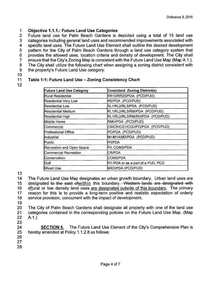
20 20
21 21
22 22
23 23

24 Exhibit 8 Drainage Map 24

25 Exhibit 9 Town of Jupiter Letter 25
26 26

27 Exhibit 10 City of West Palm Beach Resolution No
28 28
29 29

30 Exhibit 11 SRPP Transit-Supportive Policies 30
31 31
32 32
7,600 Residential Units 1,700,000 SF Non-Res 300-Room ALF 300-Room Hotel University School, Park, Civic parcels 1,889 ac flow-way/preservation
 4,763 ac undeveloped long-term AG use Over 75% characterized by non-native & invasive species Has severely degraded habitat functions 11,565 of frontage along Northlake Blvd. 1,687 of frontage along Beeline
TREASURE COAST REGIONAL PLANNING COUNCIL M E M O R A N D U M. To: Council Members AGENDA ITEM 8B5
 TREASURE COAST REGIONAL PLANNING COUNCIL M E M O R A N D U M To: Council Members AGENDA ITEM 8B5 From: Date: Subject: Staff February 17, 2017 Council Meeting Local Government Comprehensive Plan Review
TREASURE COAST REGIONAL PLANNING COUNCIL M E M O R A N D U M. To: Council Members AGENDA ITEM 5H
 TREASURE COAST REGIONAL PLANNING COUNCIL M E M O R A N D U M To: Council Members AGENDA ITEM 5H From: Date: Subject: Staff October 17, 2008 Council Meeting Local Government Comprehensive Plan Review Draft
DRAFT Subject to Modifications
 DRAFT Subject to Modifications TREASURE COAST REGIONAL PLANNING COUNCIL M E M O R A N D U M To: Council Members AGENDA ITEM 7C8 From: Date: Subject: Staff January 20, 2017 Council Meeting Local Government
TREASURE COAST REGIONAL PLANNING COUNCIL M E M O R A N D U M. To: Council Members AGENDA ITEM 4B3
 Revision: 3-15-19 TREASURE COAST REGIONAL PLANNING COUNCIL M E M O R A N D U M To: Council Members AGENDA ITEM 4B3 From: Staff Date: March 8, 2019 Subject: Local Government Comprehensive Plan Review Draft
MEMORANDUM AGENDA ITEM #6c
 South Florida Regional Planning Council MEMORANDUM AGENDA ITEM #6c DATE: FEBRUARY 1, 2010 TO: FROM: SUBJECT: COUNCIL MEMBERS STAFF CITY OF PARKLAND PROPOSED COMPREHENSIVE PLAN AMENDMENT (ALTERNATIVE REVIEW)
 PROJECT NARRATIVE AVENIR PCD SITE PLAN #2 SITE PLAN REVIEW March 14, 2018 Request Avenir Holdings, LLC, the owner of the approved Avenir Planned Urban Planning and Design Landscape Architecture Communication
DRAFT Subject to Modifications
 DRAFT Subject to Modifications TREASURE COAST REGIONAL PLANNING COUNCIL M E M O R A N D U M To: Council Members AGENDA ITEM 7C10 From: Date: Subject: Staff January 20, 2017 Council Meeting Local Government
TREASURE COAST REGIONAL PLANNING COUNCIL M E M O R A N D U M. To: Council Members AGENDA ITEM 5I
 TREASURE COAST REGIONAL PLANNING COUNCIL M E M O R A N D U M To: Council Members AGENDA ITEM 5I From: Date: Subject: Staff December 12, 2008 Council Meeting Local Government Comprehensive Plan Review Town
TREASURE COAST REGIONAL PLANNING COUNCIL M E M O R A N D U M. To: Council Members AGENDA ITEM 3I
 TREASURE COAST REGIONAL PLANNING COUNCIL M E M O R A N D U M To: Council Members AGENDA ITEM 3I From: Date: Subject: Staff December 8, 2017 Council Meeting Local Government Comprehensive Plan Review Draft
TREASURE COAST REGIONAL PLANNING COUNCIL M E M O R A N D U M. To: Council Members AGENDA ITEM 4B15
 TREASURE COAST REGIONAL PLANNING COUNCIL M E M O R A N D U M To: Council Members AGENDA ITEM 4B15 From: Date: Subject: Staff May 18, 2018 Council Meeting Local Government Comprehensive Plan Review Draft
CHARLES PUTMAN CHARLES PUTMAN AND ASSOCIATES, INC
 MEMORANDUM CHARLES PUTMAN & ASSOCIATES, INC. LAND DEVELOPMENT CONSULTANTS PLANNING ZONING PERMITTING 4722 NW Boca Raton Boulevard, Suite C-106 Boca Raton, Florida 33431 Phone: 561/994-6411 FAX: 561/994-0447
DRAFT Subject to Modifications
 TREASURE COAST REGIONAL PLANNING COUNCIL M E M O R A N D U M To: Council Members AGENDA ITEM 5P From: Date: Subject: Staff February 20, 2009 Council Meeting Local Government Comprehensive Plan Review Draft
MEMORANDUM AGENDA ITEM #IV.C
 MEMORANDUM AGENDA ITEM #IV.C DATE: NOVEMBER 27, 2017 TO: FROM: COUNCIL MEMBERS STAFF SUBJECT: LOCAL GOVERNMENT COMPREHENSIVE PLAN PROPOSED AND ADOPTED AMENDMENT CONSENT AGENDA Pursuant to Section 163.3184,
TREASURE COAST REGIONAL PLANNING COUNCIL M E M O R A N D U M. February 19, 2010 Regional Planning Council Meeting
 TREASURE COAST REGIONAL PLANNING COUNCIL M E M O R A N D U M To: Council Members AGENDA ITEM 5H From: Date: Subject: Staff February 19, 2010 Regional Planning Council Meeting Local Government Comprehensive
CITY OF TARPON SPRINGS DCA#11-1AR
 Agenda Item #3.H.2 05/09/11 TAMPA BAY REGIONAL PLANNING COUNCIL LOCAL GOVERNMENT COMPREHENSIVE PLAN ADOPTED AMENDMENT REPORT CITY OF TARPON SPRINGS DCA#11-1AR 1 ADOPTED WITH THE FOLLOWING CHANGES: Ordinance
INTERGOVERNMENTAL COORDINATION ELEMENT
 Goals, Objectives and Policies COORDINATION ELEMENT GOAL 8.1.: ESTABLISH EFFECTIVE COORDINATION MEASURES AMONG ALL PERTINENT PUBLIC AND QUASI-PUBLIC ENTITIES SO TO BEST MAINTAIN PALM BEACH GARDENS' QUALITY
Ten Mile Creek Planning Area
 PLANNING AREA POLICIES TEN MILE CREEK Ten Mile Creek Planning Area Location and Context The Ten Mile Creek Planning Area ( Ten Mile Creek area ) is located south of the current Boise AOCI, generally south
Secrest Short Cut and Monroe Expressway Small Area Plan AUGUST 29, 2018
 Secrest Short Cut and Monroe Expressway Small Area Plan AUGUST 29, 2018 Background and Process Monroe Expressway will be open by the end of 2018 Union County and Indian Trail identified a need to revisit
AWH REPORT OF THE PLANNING AND DEVELOPMENT DEPARTMENT FOR APPLICATION FOR REZONING ORDINANCE TO PLANNED UNIT DEVELOPMENT
 AWH REPORT OF THE PLANNING AND DEVELOPMENT DEPARTMENT FOR APPLICATION FOR REZONING ORDINANCE TO PLANNED UNIT DEVELOPMENT MAY 8, 2014 The Planning and Development Department hereby forwards to the Planning
SUBJECT: LOCAL GOVERNMENT COMPREHENSIVE PLAN PROPOSED AND ADOPTED AMENDMENT CONSENT AGENDA
 MEMORANDUM AGENDA ITEM #IV.C DATE: APRIL 15, 2019 TO: FROM: COUNCIL MEMBERS STAFF SUBJECT: LOCAL GOVERNMENT COMPREHENSIVE PLAN PROPOSED AND ADOPTED AMENDMENT CONSENT AGENDA Pursuant to the 1974 Interlocal
open public hearing and allow public comment request to continue LPA public hearing to January 16, 2014 at 10:30 am
 TODAY S AGENDA Work Session LPA Transmittal Public Hearing open public hearing and allow public comment request to continue LPA public hearing to January 16, 2014 at 10:30 am staff will issue a recommendation
3.10 LAND USE SETTING PROJECT SITE EXISTING LAND USE DESIGNATIONS AND ZONING. General Plan Land Use Designations.
 This section of the Draft EIR addresses the existing land uses on and adjacent to the project site and discusses the potential impacts of the proposed project on existing land uses. Key issues addressed
Mitchell Ranch South MPUD Application for Master Planned Unit Development Approval Project Narrative. Introduction
 Mitchell Ranch South MPUD Application for Master Planned Unit Development Approval Project Narrative Introduction Mitchell Ranch South is a proposed single family (detached) residential development on
TRANSPORTATION ELEMENT GOALS, OBJECTIVES, AND POLICIES
 TRANSPORTATION ELEMENT GOALS, OBJECTIVES, AND POLICIES GOAL 2 The City shall provide a safe, convenient, effective, and energy efficient multimodal transportation system which is coordinated with the Future
DRAFT MAP AMENDMENT FLU 04-4
 DRAFT MAP AMENDMENT FLU 04-4 SW 24 TH AVENUE ROADWAY CORRIDOR The University of Florida participates with the Metropolitan Transportation Planning Organization (MTPO) in its responsibilities for the continuing,
CONSERVATION ELEMENT. LISTED SPECIES Those species designated as endangered, threatened, or of special concern.
 CONSERVATION ELEMENT Definitions: LISTED SPECIES Those species designated as endangered, threatened, or of special concern. PROTECTED Refers to official federal, state, or internationally treaty lists
Woodburn Comprehensive Plan Growth Management Goals and Policies
 Goal Woodburn Comprehensive Plan Growth Management Goals and Policies G-1. The City's goal is to manage growth in a balanced, orderly and efficient manner, consistent with the City s coordinated population
FUTURE LAND USE ELEMENT
 Goals, Objectives and Policies FUTURE LAND USE ELEMENT GOAL 1.1.: CONTINUE TO ENSURE A HIGH QUALITY LIVING ENVIRONMENT THROUGH A MIXTURE OF LAND USES THAT WILL MAXIMIZE PALM BEACH GARDENS' NATURAL AND
12 January 12, 2011 Public Hearing APPLICANT: TAILWIND DEVELOPMENT GROUP,LLC PROPERTY OWNER: CITY OF VIRGINIA BEACH
 12 January 12, 2011 Public Hearing APPLICANT: TAILWIND DEVELOPMENT GROUP,LLC PROPERTY OWNER: CITY OF VIRGINIA BEACH STAFF PLANNER: Faith Christie REQUEST: Conditional Change of Zoning (from PD-H1 Planned
DRAFT Subject to Modifications
 TREASURE COAST REGIONAL PLANNING COUNCIL M E M O R A N D U M DRAFT Subject to Modifications To: Council Members AGENDA ITEM 5F From: Date: Subject: Staff September 17, 2010 Council Meeting Local Government
1934 Commerce Lane Suite 1 Jupiter, Florida Ph Fax Lic # LC-C ATTACHMENT G.
 Landscape Architects I Land Planners I Environmental Consultants 1934 Commerce Lane Suite 1 Jupiter, Florida 33458 Ph 561.747.6336 Fax 561.747.1377 www.cotleurhearing.com Lic # LC-C000239 ATTACHMENT G
Venice Pumping Plant Dual Force Main Project Draft EIR
 City of Los Angeles 5.9 LAND USE PLANS 5.9.1 Environmental Setting Venice Pumping Plant Dual Force Main Project Draft EIR The Project lies within the bounds of Los Angeles County and the City of Los Angeles.
Future Land Use and Transportation
 Planning & Zoning Board Workshop Comprehensive Plan for Village of Estero Future Land Use and Transportation April 6, 2017 January Kick-off Meeting Public Input What do you like about Estero? Location
Baumgarten MPUD. Exhibit 3 Evaluation Criteria
 Pursuant to LDC subsections 10.02.13 B, 10.02.08 F and Chapter 3 G. of the Administrative Code, staff s analysis and recommendation to the Planning Commission, and the Planning Commission s recommendation
Improve Neighborhood Design and Reduce Non Point Source Water Pollution
 HOW TO Planning Guide Improve Neighborhood Design and Reduce Non Point Source Water Pollution This document was funded by a grant from the New Hampshire Coastal Program with funding from the National Oceanic
TRANSPORTATION ELEMENT
 TRANSPORTATION ELEMENT GOAL I: To create and maintain a safe, efficient and aesthetic transportation system that encourages multi-modal transportation and promotes the mobility strategies of the Ocala
DRAFT Subject to Modifications TREASURE COAST REGIONAL PLANNING COUNCIL
 DRAFT Subject to Modifications TREASURE COAST REGIONAL PLANNING COUNCIL M E M O R A N D U M To: Council Members AGENDA ITEM 7C From: Date: Subject: Staff June 22, 2007 Council Meeting Local Government
Subject: Hendry County Evaluation and Appraisal Report Letter of Understanding - Identification of Major Issues
 HENDRY COUNTY PLANNING & ZONING DEPARTMENT POST OFFICE BOX 2340 165 S. LEE STREET LABELLE, FLORIDA 33975 (863) 675-5240 FAX: (863) 675-5317 SUNCOM 744-4750 November 16, 2007 Mr. Mike McDaniel, Chief Office
Asbury Chapel Subdivision Sketch Plan
 Asbury Chapel Subdivision Sketch Plan PART 1: PROJECT SUMMARY Applicant: NVR Inc. Project Size: +/- 76.13 acres Parcel Numbers: 02101112,02116101,02116112, 02116113 Current Zoning: Transitional Residential
BROOKHILL NEIGHBORHOOD MODEL ZONING MAP AMENDMENT PREFACE TO APPLICATION
 BROOKHILL NEIGHBORHOOD MODEL ZONING MAP AMENDMENT PREFACE TO APPLICATION June 15, 2015 Revised: August 1, 2016 I. VISION Brookhill is a proposed community based upon the principles of Albemarle County
Gold Line Bus Rapid Transit Transit Oriented Development (BRTOD) Helmo Station Area Plan
 Helmo Station Area Plan") Appendix F Gold Line Bus Rapid Transit Transit Oriented Development (BRTOD) Helmo Station Area Plan Introduction and Purpose of the Plan The Gold Line Bus Rapid Transit facility is an eleven-mile dedicated
Appendix F Gold Line Bus Rapid Transit Transit Oriented Development (BRTOD) Helmo Station Area Plan Introduction and Purpose of the Plan The Gold Line Bus Rapid Transit facility is an eleven-mile dedicated
Staff Report and Recommendation
 Community Planning and Development Planning Services 201 W. Colfax Ave., Dept. 205 Denver, CO 80202 p: 720.865.2915 f: 720.865.3052 www.denvergov.org/cpd TO: City Council Neighborhoods and Planning Committee
COLVER ROAD INDUSTRIAL CONCEPT PLAN
 COLVER ROAD INDUSTRIAL CONCEPT PLAN A CONCEPTUAL LAND USE AND TRANSPORTATION PLAN FOR TA-4 AN URBAN RESERVE AREA OF THE CITY TALENT City of Talent Adopted by City Council Resolution No., June, 2015 PART
USA Addition of South & East Side Residential Parcels. USA Deletion of a Town of Christiana Parcel. Conversion from USA to Limited Service Area
 Village of Rockdale Village of Rockdale 148 Water Street Cambridge, WI 53523 Phone 608.423.1497 Fax 608.423.9694 Urban Service Area (USA) Amendment USA Addition of South & East Side Residential Parcels
Narcoossee Roadway Corridor
 Community Meeting Narcoossee Roadway Corridor April 5, 2012 Meeting Agenda Purpose of Meeting Continuation of Study Update Process (Previous Meetings Oct. & Nov., 2011) Tonight s Objective Review Proposals
REQUEST Current Zoning: O-15(CD) (office) Proposed Zoning: TOD-M(CD) (transit oriented development mixed-use, conditional)
 (office) Proposed Zoning: TOD-M(CD) (transit oriented development mixed-use, conditional)") Rezoning Petition 2016-117 Zoning Committee Recommendation January 4, 2017 REQUEST Current Zoning: O-15(CD) (office) Proposed Zoning: TOD-M(CD) (transit oriented development mixed-use, conditional) LOCATION
Rezoning Petition 2016-117 Zoning Committee Recommendation January 4, 2017 REQUEST Current Zoning: O-15(CD) (office) Proposed Zoning: TOD-M(CD) (transit oriented development mixed-use, conditional) LOCATION
Michael D, Harvey, Current Planning Supervisor. This project was originally approved in 2012 by the BOCC and is summarized as follows:
 PLANNING & INSPECTIONS DEPARTMENT Craig N. Benedict, AICP, Director Current Planning (919) 245-2575 (919) 644-3002 (FAX) www.orangecountync.gov 131 W. Margaret Lane Suite 201 P. O. Box 8181 Hillsborough,
Major Subdivision Sketch Plan Checklist
 This checklist provides specific requirements that are apart of the Sketch process. The entire process is described by the Huntersville Subdivision Review Process which details all the submittal and resubmittal
Chapter 12 GENERAL STRATEGY
 GOAL: Vision: Section 163.3245, Florida Statutes "supports innovative and flexible planning and development strategies" through the Sector Plan process as a tool to encourage long-term planning for conservation,
Dwelling Units Max 12 dwelling units per acre/min 8 dwelling units per acre. Development Mix 80% non residential/20% residential
 13. OSTEEN LOCAL PLAN Background: The Osteen Local Plan area is located in southwest Volusia County along the SR 415 corridor between Lemon Bluff Road and Acorn Lake Road and includes 3,990 acres. The
CONSERVATION ELEMENT:
 CONSERVATION ELEMENT: Goals, Objectives and Policies Goal 1: To conserve, protect and enhance the functions and values of the natural resources within Jupiter to ensure the highest environmental quality
PART 1: PROJECT SUMMARY. Proposed Land Use: 120 single-family lots. The application is Attachment A. The site plan is Attachment B.
 PART 1: PROJECT SUMMARY Applicant: JBH Development, LLC and Hopper Communities, INC Project Size: +/- 80.48 acres Parcel Number: 01513107, 01513108, 01513109, 01513113, 01513120, 01513121, 01513122, 01513124,
The transportation system in a community is an
 7 TRANSPORTATION The transportation system in a community is an important factor contributing to the quality of life of the residents. Without a sound transportation system to bring both goods and patrons
1.0 Circulation Element
 5/9/18 1.0 Circulation Element 1.1 Introduction As growth and development occur in Apache County, enhancements to its circulation system will be necessary. With time, more roads will be paved and air and
Chapter 10 IMPLEMENTATION RECOMMENDATIONS
 Chapter 10 IMPLEMENTATION RECOMMENDATIONS The recommended land use plan presented in the previous chapter provides a design for the attainment of the urban and rural development and open space preservation
VILLAGE OF CLEMMONS PLANNING BOARD DRAFT STAFF REPORT. Single Family Residential, Townhomes
 VILLAGE OF CLEMMONS PLANNING BOARD DRAFT STAFF REPORT PETITION INFORMATION Docket # C-212 Staff Megan Ledbetter Petitioner(s) Peacehaven Development LLC Owner(s) Larry Jarvis, William Alexander and Peacehaven
GENERAL PLAN UPDATE ISSUES MEETING. January 21, 2010 City Hall Mitchell Room 6:00 pm 9:00 pm
 GENERAL PLAN UPDATE ISSUES MEETING January 21, 2010 City Hall Mitchell Room 6:00 pm 9:00 pm WELCOME! Introductory Comments Continued Review of Quality of Life Standards, Growth Management, Proposition
CHAPTER 12 IMPLEMENTATION
 CHAPTER 12 IMPLEMENTATION The 2010 Town of Denton Comprehensive Plan is intended to capture a vision of the future of Denton. As such, it provides a basis for a wide variety of public and private actions
Chapter 13: Implementation Plan
 Implementation A. Introduction The Implementation Plan, in table form on the following pages, provides a summary of all the Action Items recommended in Chapters 2 through 12. The table also indicates which
VILLAGE OF PALM SPRINGS COMPREHENSIVE PLAN GOALS, OBJECTIVES AND POLICIES
 VILLAGE OF PALM SPRINGS COMPREHENSIVE PLAN GOALS, OBJECTIVES AND POLICIES Adopted November 12, 2009 Amended October 9, 2014 Amended Janury 14, 2016 Amended November 10, 2016 Amended January 11, 2018 (EAR-based)
City of Grande Prairie Development Services Department KENNEDY DEVELOPMENTS LTD. OUTLINE PLAN OP-09-01
 City of Grande Prairie Development Services Department KENNEDY DEVELOPMENTS LTD. OUTLINE PLAN OP-09-01 July 27, 2009 TABLE OF CONTENTS 1.0 Introduction... 1 1.1 Plan Area Location & Context... 1 1.2 Ownership
G. RECREATION AND OPEN SPACE ELEMENT. The following summarizes the Recreation and Open Space Element:
 G. RECREATION AND OPEN SPACE ELEMENT The purpose of the Element is to provide the framework and direction for a comprehensive system of public and private sites for recreation, including, but not limited
STAFF SUMMARY FOR S17-02 SPECIAL USE PERMIT APPLICATION
 APPLICATION SUMMARY Case Number: S17-02 Request: STAFF SUMMARY FOR S17-02 SPECIAL USE PERMIT APPLICATION SUP application in order to develop a convenience food store. Applicant: Property Owner(s): Cindee
Planning & Zoning Commission Staff Report
 Planning & Zoning Commission Staff Report Meeting Date: May 26, 2015 Drafted by: Katherine Harrison-Rogers CASE # Z2886 PROJECT NAME: APPLICANT/ REPRESENTATIVE: Shawna Runyan PROPERTY OWNER: 1840 (previously
Description of Preferred Alternative
 Chapter 2 Description of Preferred Alternative 2.1 Introduction This chapter of the programmatic Sammamish Town Center Sub-area Plan Final EIS provides a more detailed description of the Preferred Alternative
12 February 9, 2011 Public Hearing APPLICANT: WILDLIFE RESPONSE, INC.
 12 February 9, 2011 Public Hearing APPLICANT: WILDLIFE RESPONSE, INC. PROPERTY OWNER: CITY OF VIRGINIA BEACH REQUEST: Conditional Use Permit (Wildlife Rehabilitation Center) STAFF PLANNER: Karen Prochilo
ARTICLE 6: Special and Planned Development Districts
 ARTICLE 6: Special and Planned Development Districts 6-10 Traditional Neighborhood Development (TND) District 6-10.10 Purpose and Intent The Traditional Neighborhood Development (TND) District provides
CHAPTER 7: Transportation, Mobility and Circulation
 AGLE AREA COMMUNITY Plan CHAPTER 7 CHAPTER 7: Transportation, Mobility and Circulation Transportation, Mobility and Circulation The purpose of the Transportation, Mobility and Circulation Chapter is to
9 CITY OF VAUGHAN OFFICIAL PLAN AMENDMENT NO BOCA EAST INVESTMENTS LIMITED
 9 CITY OF VAUGHAN OFFICIAL PLAN AMENDMENT NO. 631 - BOCA EAST INVESTMENTS LIMITED The Planning and Economic Development Committee recommends the adoption of the recommendations contained in the following
PART 1: PROJECT SUMMARY. The application is Attachment A. The site plan is Attachment B.
 Belleterre Subdivision Sketch Plan Town Board 8.7.17 Belleterre Subdivision Sketch Plan PART 1: PROJECT SUMMARY Applicant: Bowman Development Project Size: +/- 20.85 acres Parcel Number: 01115104 and 01115121
2025 COMPREHENSIVE PLAN PASCO COUNTY, FLORIDA
 GOAL FLU 6: PASADENA HILLS FUTURE LAND USE: PASADENA HILLS AREA PLAN GOALS, OBJECTIVES, AND POLICIES PASADENA HILLS AREA PLAN: OVERVIEW The Pasadena Hills Area Plan Goals, Objectives, and Policies are
Planning Commission April 4, 2013 BOCC Workshop Page 1
 Planning Commission April 4, 2013 BOCC Workshop Page 1 Planning Commission April 4, 2013 BOCC Workshop Page 2 Planning Commission April 4, 2013 BOCC Workshop Page 3 Planning Commission April 4, 2013 BOCC
Osceola County Board of County Commissioners 1 Courthouse Square, Suite 1100 Kissimmee, FL
 1/10/11 Item Number DRI08-0006 Osceola County Board of County Commissioners 1 Courthouse Square, Suite 1100 Kissimmee, FL 34741 407-742-0200 Applicant & Owner Center Lake Properties, LLLP and Formally
2 January 13, 2010 Public Hearing APPLICANT: AUTOBELL CAR WASH, INC
 REQUEST: Conditional Use Permit (car wash) 2 January 13, 2010 Public Hearing APPLICANT: AUTOBELL CAR WASH, INC PROPERTY OWNER: MESSER 1060 INDEPENDENCE BOULEVARD STAFF PLANNER: Carolyn A.K. Smith ADDRESS
PLANNING COMMISSION. Agenda Item # 3.
 PLANNING COMMISSION Agenda Item # 3. CASE SUMMARY Conditional District Rezoning Planning Commission February 4, 2015 CD-9-215 Jeff Walton, 341-3260, jeff.walton@wilmingtonnc.gov Staff recommendation CONDITIONAL
COMMUNITY DESIGN. GOAL: Create livable and attractive communities. Intent
 COMMUNITY DESIGN Intent An attractive, well-designed County will attract quality development, instill civic pride, improve the visual character of the community, and create a strong, positive image for
RECREATION, OPEN SPACE AND GREENWAYS ELEMENT GOALS, OBJECTIVES, AND POLICIES
 RECREATION, OPEN SPACE AND GREENWAYS ELEMENT GOALS, OBJECTIVES, AND POLICIES GOAL R-1: DEVELOP A RECREATION, OPEN SPACE AND GREENWAYS SYSTEM AS AN INTEGRAL COMPONENT OF AN OVERALL, COUNTY-WIDE ECONOMIC
LAND USE ELEMENT. Purpose. General Goals & Policies
 LAND USE ELEMENT Purpose This Land Use Element contains the goals and policies necessary to support the City s responsibility for managing land resources and guiding development through implementing regulations,
Micco Park Village Development
 FOR SALE Call For Pricing Micco Park Village Development Proposed Project Property Details Micco Park Village Development PRICE Call For Pricing A monumental development opportunity of a lifetime! The
EXECUTIVE SUMMARY DRAFT CHAPTER 1 INTRODUCTION EXECUTIVE SUMMARY
 CHAPTER 1 EXECUTIVE SUMMARY INTRODUCTION Through the joint efforts of the City of Tulsa planning staff and the Land Services division of Indian Nations Council of Governments (INCOG), the Berryhill Land
THREE-STEP DESIGN PROCESS FOR OPEN SPACE SUBDIVISIONS
 00216106.DOC NMA/RRK 1/30/14 THREE-STEP DESIGN PROCESS FOR OPEN SPACE SUBDIVISIONS Open space subdivisions, sometimes called cluster developments, maintain a significant portion of a development site in
SECTION UNIFIED DEVELOPMENT ORDINANCE SECTION Part 1 Ordinance. ARTICLE 1 Zoning Districts
 SECTION 1-100 UNIFIED DEVELOPMENT ORDINANCE SECTION 1-300 Part 1 Ordinance SECTION 1-100. Introduction. ARTICLE 1 Zoning Districts Crystal Lake strives to maintain a balance of various land uses for a
SUSSEX COUNTY COMPREHENSIVE PLAN COUNTY PLANNING AND ZONING COMMISSION WORKSHOP
 SUSSEX COUNTY COMPREHENSIVE PLAN COUNTY PLANNING AND ZONING COMMISSION WORKSHOP August 21, 2017 TODAY S WORKSHOP Public Comment Utilities Update Economic Development Update Future Land Use Discussion Public
SECTION 4(f) DE MINIMIS DOCUMENTATION
 DE MINIMIS DOCUMENTATION") SECTION 4(f) DE MINIMIS DOCUMENTATION Illinois Route 60/83 IL 176 to the intersection of IL 60 (Townline Road) Lake County P-91-084-07 Mundelein Park and Recreation District Project Limit SECTION 4(f)
SECTION 4(f) DE MINIMIS DOCUMENTATION Illinois Route 60/83 IL 176 to the intersection of IL 60 (Townline Road) Lake County P-91-084-07 Mundelein Park and Recreation District Project Limit SECTION 4(f)
14 October 10, 2012 Public Hearing APPLICANT: MPB, INC
 14 October 10, 2012 Public Hearing APPLICANT: MPB, INC PROPERTY OWNER: MUNDEN & ASSOCIATES, LP STAFF PLANNER: Karen Prochilo REQUEST: Conditional Change of Zoning (AG-1 & AG-2 to Conditional O-2) ADDRESS
Review of Opportunity Area C Draft Comprehensive Plan and Draft BOS Follow-On Motions. Special Working Group Meeting March 4, 2015
 Review of Opportunity Area C Draft Comprehensive Plan and Draft BOS Follow-On Motions Special Working Group Meeting March 4, 2015 The slides that follow identify where the draft Comprehensive Plan has
Living in Albemarle County s Urban Places
 Living in Albemarle County s Urban Places ALBEMARLE COUNTY, VIRGINIA A Closer Look at Albemarle s Approach to Managing Growth and Creating Quality Urban Environments www.albemarle.org Page 2 Living in
ORDINANCE NO WHEREAS, the recommendations from the Pinellas County Local Planning Agency have been received and considered.
 ORDINANCE NO. 16-55 AN ORDINANCE OF THE COUNTY OF PINELLAS, AMENDING THE FUTURE LAND USE AND QUALITY COMMUNITIES ELEMENT OF THE PINELLAS COUNTY COMPREHENSIVE PLAN TO ADOPT THE CRYSTAL BEACH COMMUNITY OVERLAY;
LU Encourage schools, institutions, and other community facilities that serve rural residents to locate in neighboring cities and towns.
 Application No. 891627: Comprehensive Plan Text Amendment - Rural School Policies - Amend policies consistent with State Legislation allowing schools in the rural area and extension of sewer service to
Drexel, Barrell & Co.
 Drexel, Barrell & Co. June 18, 2018 Engineers/Surveyors Boulder Colorado Springs Greeley 3 South 7 th Street Colorado Springs, Colorado 80905-1501 719 260-0887 719 260-8352 Fax El Paso County Planning
PINE CURVE REZONING. BACKGROUND Purchased as two parcels in 2001 and 2002
 BACKGROUND Purchased as two parcels in 2001 and 2002 WHAT THE PROJECT IS AND IS NOT A Rezoning establishes the land use standards for Annexed and Zoned Greater Downtown District Historic Center September
Clackamas County Comprehensive Plan. Chapter 4: LAND USE
 Chapter 4: LAND USE When the pioneers settled Clackamas County, the land resource appeared infinite. They cleared forest, carved towns from the wilderness, and used waterways as the arterials of commerce.
ROAD CLOSURE AND LAND USE AMENDMENT SILVER SPRINGS (WARD 1) NORTHEAST OF NOSEHILL DRIVE NW AND SILVER SPRINGS ROAD NW BYLAWS 2C2018 AND 29D2018
 NORTHEAST OF NOSEHILL DRIVE NW AND SILVER SPRINGS ROAD NW BYLAWS 2C2018 AND 29D2018") Page 1 of 19 EXECUTIVE SUMMARY This application proposes redesignating two parcels in the community of Silver Springs from Special Purpose Future Urban Development (S-FUD) District and undesignated road
Page 1 of 19 EXECUTIVE SUMMARY This application proposes redesignating two parcels in the community of Silver Springs from Special Purpose Future Urban Development (S-FUD) District and undesignated road
Rezoning Petition Pre-Hearing Staff Analysis September 17, 2018
 Rezoning Petition 2017-043 Pre-Hearing Staff Analysis September 17, 2018 REQUEST Current Zoning: R-3 (single family residential), R-17MF (multi-family residential), and CC (commercial center) Proposed
4. ENVIRONMENTAL IMPACT ANALYSIS 7. LAND USE AND PLANNING
 4. ENVIRONMENTAL IMPACT ANALYSIS 7. LAND USE AND PLANNING 4.7.1 INTRODUCTION The following analysis discusses the consistency of the Proposed Project with the corresponding land use and zoning designations
CHAPTER 7: VISION AND ACTION STATEMENTS. Noble 2025 Vision Statement
 CHAPTER 7: VISION AND ACTION STATEMENTS This chapter presents the vision, policy and action statements that transform the comprehensive planning study, an analysis of Noble s past, future trends and community
9 th Street Sub Area Plan
 9 th Street Sub Area Plan In the 1990 s, when the Township prepared the last Master Plan, the 9 th Street corridor was studied as part of a larger 9 th Street Focus Area that included the West Main Street
Applicant Name Phone / Fax / Address City State Zip Code . Property Owner Phone / Fax / Address City State Zip Code
 Master Development Plan Application Community Development Department City of Redmond 411 SW 9 th Street Redmond, Oregon 97756 541-923-7721 541-548-0706 FAX Master Development Plan Fee $38,862.52 File Number
Ridgefield and the Growth Management Act
 1 2 Ridgefield and the Growth Management Act 3 Why Do We Plan History of Planning in Ridgefield Washington experiences rapid growth in the late 1980 s that began to change the perceived quality of life.