BUILD Central Main Street Corridor Redevelopment Plan Public Meeting No. 3. September 14, 2017
|
|
|
- Kerry Parks
- 5 years ago
- Views:
Transcription


1 BUILD Central Main Street Corridor Redevelopment Plan Public Meeting No. 3 September 14, 2017

2 Follow Up Questions raised at the June meeting: Why are we doing this? Can t we just keep this area the same? Traffic questions Questions about the purpose of the concept plans
3 Main Street 2002 Pamida Store had closed (Off-Road Liquidators) Main Street Anchors Sentry Hanley Hardware Dorn True Value Variety Store Golf Store Main Street was the City s Primary Retail Area Downtown had not yet seen any redevelopment Westside was years off Windsor Street area was anchored by a vacant Kohl s grocery store


4 Dorn True Valued moved to Windsor Street 2003 Prairie Towing Moved to the Biz Park 2001 Kwik Trip Opened 2002 Patio Pleasures Opened 2003 Ben Franklin's closed 2004 Paul's Bar Closed


5 Heckle's Marine Opened 2005 Hanely Closed Jul 2008 TID 10 Opened Jan 2009 Main Street Full Infastructure Reconstruction Jun

 2013 Paul's Bar torn")


6 Sir Hobos Fire Feb 2011 Advance Auto Opened Jun 2011 Salvatore's Open Nov 2011 Sir Hobos Re-opens Apr 2012 Marathon Station Closed (final time, tanks removed) 2013 Paul's Bar torn down Jan 2013 Sentry Closed Sep 2013 St. Vincent de Paul Opened Nov 2013 Dane County Housing Authority purchased site Apr 2014 Hanley site purchased by Main Street SP LLC Nov


 Sep 2017 Gotham Bagels Opening Oct 2017 McHenry")

7 Masonic Lodge Closed Oct 2015 TID 11 Opened Jan 2016 The Rock Opened Mar 2016 Jennings & Woldt broke ground Aug 2016 McHenry Apartments broke ground Nov 2016 Site Plan Submitted to PC for Tuchsen Trucking Site Aug 2017 Hanely site purchased by Catlyst on Main LLC (Forward Management) Sep 2017 Gotham Bagels Opening Oct 2017 McHenry Apartments anticipated tenant move in Jan Today 2019 Sep 1 - Oct 5 Central Main Street Corridor Redevelopment Plan
8 Development Inquiries Used Car Lots Body Shop Contractors Yards Research & Development Bio-Hazardous Materials Vehicle Rentals and Storage Assembly/Light Warehousing & Distribution Manufacturing Convenience Store Strip Club
9 Trends Main Street has been in decline. No Change is probably not an option. The area is and has been changing. We have options: Do nothing wait and see where this leads us. Be proactive, encourage investment and try to create an alternative future for the area.
10 Traffic Concerns From June Public Meeting Traffic volumes on Main what volumes were planned for when reconstructed? Turning movements are difficult already won t redevelopment make this worse? How will new residential development impact volumes?
11 Traffic Comparisons 64-Unit Apartment Building: 425 trips/day Drugstore (15K sf): 1,440 trips/day Convenience Store (5K sf): 4,230 trips/day Sit-Down Restaurant (10K sf): 1,270 trips/day Hardware Store (15K sf): 770 trips/day Strip Mall (10K sf): 443 trips/day Grocery Store (20K sf): 2,050 trips/day Fast Food Restaurant (6K sf): 2,980 trips/day (Estimates per the Institute of Transportation Engineers Trip Generation Manual, 9 th Edition)
12 Central Main Street Concept Plans Purpose To highlight the potential of the area To illustrate possible redevelopment scenarios To raise interest and excitement about the opportunities available in the area No pending plans for site acquisition or redevelopment No existing property owner will be forced out of their properties
13 Road Map for Discussion 1. Recap the Planning Process 1. Scope and Timeline 2. Steps in the Process 2. Strategies and Recommendations 1. Final input to be incorporated into Plan 3. Main & Bird Intersection Redevelopment Concepts 1. Site A: Northwest Corner 2. Site B: Northeast Corner 3. Site C: Southeast Corner 4. Site D: Southwest Corner 4. Bicycle and Pedestrian Map 1. Existing Connections 2. Proposed Connections 5. Placemaking Strategies 1. Review of focal nodes, kiosks, murals, and entry nodes 6. Implementation Plan 7. Workshop Stations & Next Steps 1. Final input to be incorporated into Plan
14 Road Map for Discussion 1. Recap the Planning Process 1. Scope and Timeline 2. Steps in the Process 2. Strategies and Recommendations 1. Final input to be incorporated into Plan 3. Main & Bird Intersection Redevelopment Concepts 1. Site A: Northwest Corner 2. Site B: Northeast Corner 3. Site C: Southeast Corner 4. Site D: Southwest Corner 4. Bicycle and Pedestrian Map 1. Existing Connections 2. Proposed Connections 5. Placemaking Strategies 1. Review of focal nodes, kiosks, murals, and entry nodes 6. Implementation Plan 7. Workshop Stations & Next Steps 1. Final input to be incorporated into Plan

15 Project Timeline
16 Road Map for Discussion 1. Recap the Planning Process 1. Scope and Timeline 2. Steps in the Process 2. Strategies and Recommendations 1. Final input to be incorporated into Plan 3. Main & Bird Intersection Redevelopment Concepts 1. Site A: Northwest Corner 2. Site B: Northeast Corner 3. Site C: Southeast Corner 4. Site D: Southwest Corner 4. Bicycle and Pedestrian Map 1. Existing Connections 2. Proposed Connections 5. Placemaking Strategies 1. Review of focal nodes, kiosks, murals, and entry nodes 6. Implementation Plan 7. Workshop Stations & Next Steps 1. Final input to be incorporated into Plan
17 Strategic Recommendations Encourage physical, cultural, and economic connectivity with surrounding areas. Promote a mix of commercial, residential, and public uses. Target key anchor sites as redevelopment priorities.
18 Strategy 1 Encourage physical, cultural, and economic connectivity with surrounding areas. Establish a visual and physical connection to residential areas surrounding the Corridor; Promote accessibility by designing rights-of-way that accommodate cyclists and pedestrians in addition to motor vehicles; Solidify the Corridor as a destination for retail spending and professional services that attracts consumers from outside the primary trade area
19 Strategy 2 Promote a mix of commercial, residential, and public uses. Promote mixed-use development where appropriate Focus on form rather than use throughout the Corridor Ensure land uses are in harmony with the surrounding natural and built environment
20 Strategy 3 Target key anchor sites as redevelopment priorities. Ensure anchor sites are large enough to accommodate impactful redevelopment projects Ensure anchor sites create a sense of place and provide collision spaces for community Ensure uses at key redevelopment sites are demand driven by members of the community or market area Purchase redevelopment sites for land assembly of larger development
21 Vision Statements Connected Residents and visitors will be able to easily access Corridor sites, businesses, and attractions through a variety of transportation modes. Local The Corridor will provide residents and visitors with a distinctive experience by allowing access to local small businesses and specialty landmarks. Mixed Use Corridor will strive to be a resilient community with diverse economies. Vibrant The Corridor will be a place where patrons go to attain an economic, social and cultural experience.
22 Road Map for Discussion 1. Recap the Planning Process 1. Scope and Timeline 2. Steps in the Process 2. Strategies and Recommendations 1. Final input to be incorporated into Plan 3. Main & Bird Intersection Redevelopment Concepts 1. Site A: Northwest Corner 2. Site B: Northeast Corner 3. Site C: Southeast Corner 4. Site D: Southwest Corner 4. Bicycle and Pedestrian Map 1. Existing Connections 2. Proposed Connections 5. Placemaking Strategies 1. Review of focal nodes, kiosks, murals, and entry nodes 6. Implementation Plan 7. Workshop Stations & Next Steps 1. Final input to be incorporated into Plan

23 Public Meeting No
24 Redevelopment Concepts
25 Redevelopment Concepts
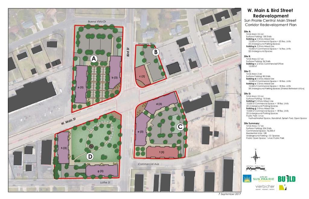
26 Redevelopment Concept

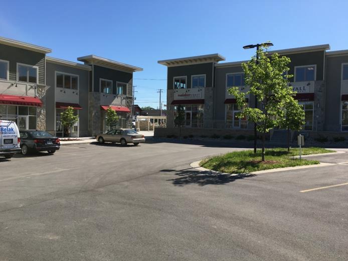
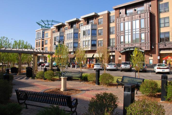
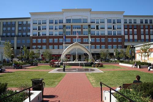
27 Examples of Development
28 Road Map for Discussion 1. Recap the Planning Process 1. Scope and Timeline 2. Steps in the Process 2. Strategies and Recommendations 1. Final input to be incorporated into Plan 3. Main & Bird Intersection Redevelopment Concepts 1. Site A: Northwest Corner 2. Site B: Northeast Corner 3. Site C: Southeast Corner 4. Site D: Southwest Corner 4. Bicycle and Pedestrian Map 1. Existing Connections 2. Proposed Connections 5. Placemaking Strategies 1. Review of focal nodes, kiosks, murals, and entry nodes 6. Implementation Plan 7. Workshop Stations & Next Steps 1. Final input to be incorporated into Plan
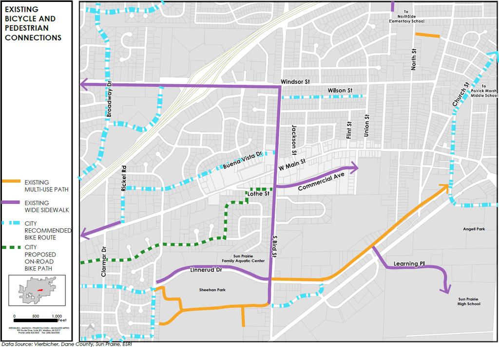
29 Existing Connections
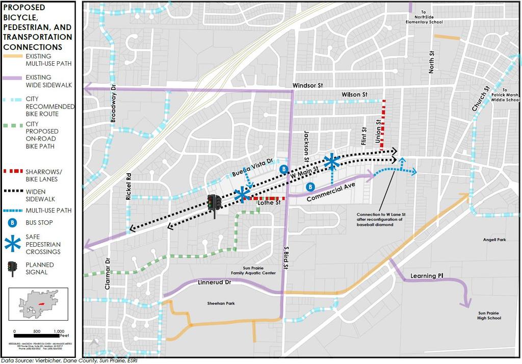
30 Proposed Connections
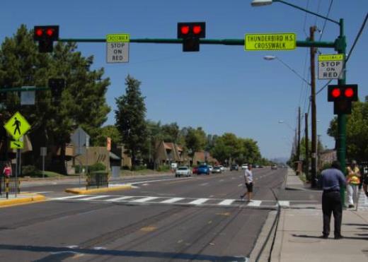
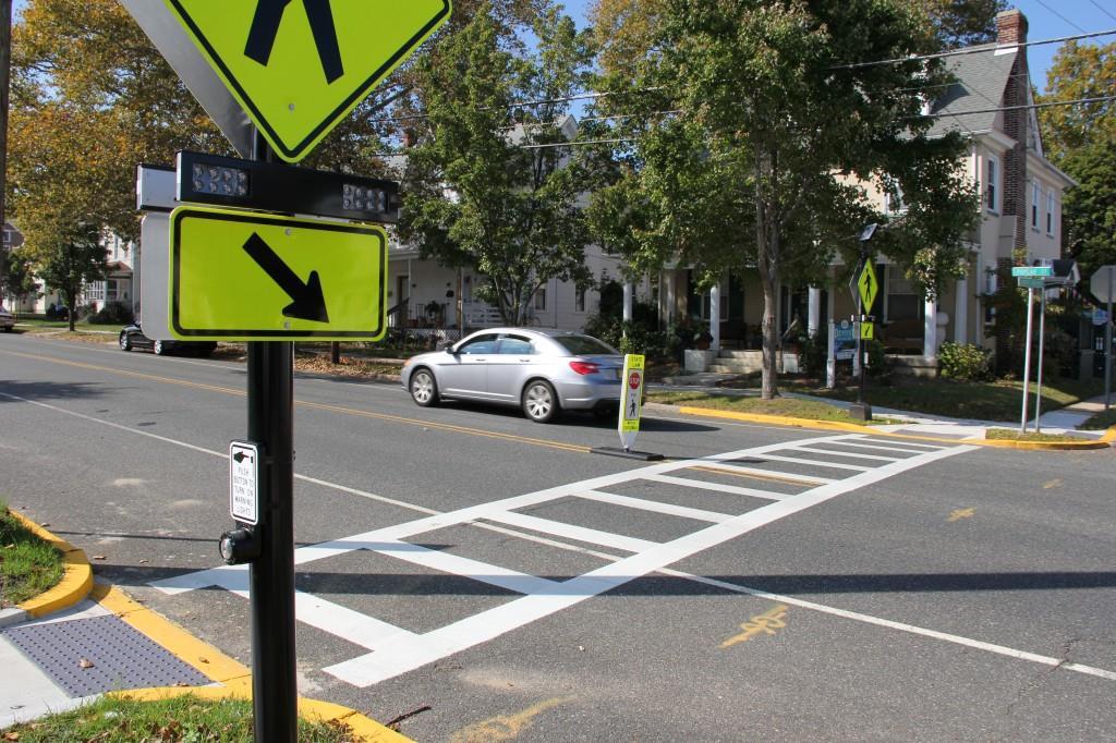
31 Proposed Pedestrian Crossings
32 Road Map for Discussion 1. Recap the Planning Process 1. Scope and Timeline 2. Steps in the Process 2. Strategies and Recommendations 1. Final input to be incorporated into Plan 3. Main & Bird Intersection Redevelopment Concepts 1. Site A: Northwest Corner 2. Site B: Northeast Corner 3. Site C: Southeast Corner 4. Site D: Southwest Corner 4. Bicycle and Pedestrian Map 1. Existing Connections 2. Proposed Connections 5. Placemaking Strategies 1. Review of focal nodes, kiosks, murals, and entry nodes 6. Implementation Plan 7. Workshop Stations & Next Steps 1. Final input to be incorporated into Plan
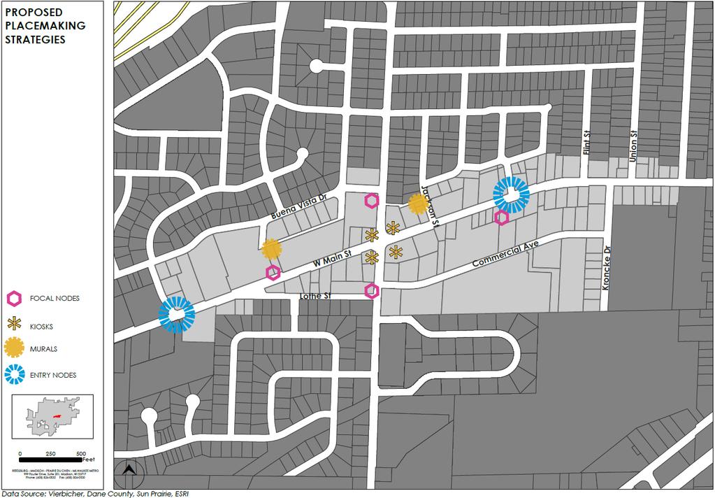
33 Placemaking Strategies

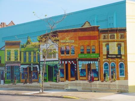
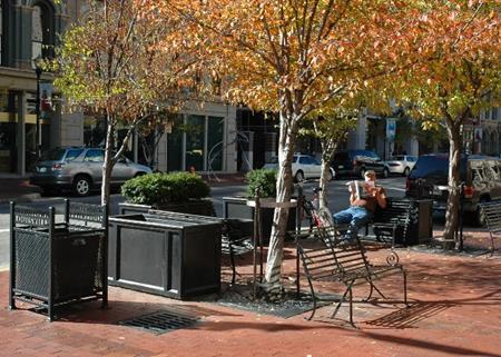
34 Place Making Strategies

35 Place Making Strategies

36 Place Making Strategies
37 Road Map for Discussion 1. Recap the Planning Process 1. Scope and Timeline 2. Steps in the Process 2. Strategies and Recommendations 1. Final input to be incorporated into Plan 3. Main & Bird Intersection Redevelopment Concepts 1. Site A: Northwest Corner 2. Site B: Northeast Corner 3. Site C: Southeast Corner 4. Site D: Southwest Corner 4. Bicycle and Pedestrian Map 1. Existing Connections 2. Proposed Connections 5. Placemaking Strategies 1. Review of focal nodes, kiosks, murals, and entry nodes 6. Implementation Plan 7. Workshop Stations & Next Steps 1. Final input to be incorporated into Plan


38 Implementation Strategies Chapter Implementation Strategies Placemaking Develop community-wide wayfinding signage system. Establish gateway features at all community entrances. Create Multi-family Housing Strategy- Identify sites and promote sites to developers for new, infill, or rehabilitation. Consider adaptive reuse by turning old warehouses or large vacant buildings into live-work uses. Create a flexible street program to alllow for street closures for economic development and recreational uses. Work the Chamber to create an identifiable brand to market city. Elected Officials City Administration City City Public Works/Engineering City Parks & Recreation Roles Planning Community Developm BID Other County Service Clubs Residents/Property Owners Action Timeframe Cost L* S P T1 $ L S P T1 $ L P T1 $ L R T2 $ C L S S S S P T2 $$ S S L* S S P T1 $ Program or regulatory change Priority and Timing Project and/or capital imrovement cost

39 Next Steps Community Development Authority September 25, 2017 Plan Commission October 2017 Final approval Common Council
40 BUILD Central Main Street Corridor Redevelopment Plan Public Meeting No. 3 September 14, 2017
LUNDY S LANE COMMUNITY IMPROVEMENT PLAN STUDY
 PUBLIC INFORMATION MEETING #2 October 12, 2016 LUNDY S LANE COMMUNITY IMPROVEMENT PLAN STUDY AGENDA 5:00 to 5:30pm: Open House 5:30 to 6:15pm: Presentation 6:15 to 7:00pm: Individual paced workshop with
New Westminster Downtown Parking Strategy Public Open House #1 September 13, 2012
 New Westminster Downtown Parking Strategy Public Open House #1 September 13, 2012 The City is preparing a strategy for parking in Downtown New Westminster. The study team and a group of key stakeholders
Corridors. Re-vitalize our Corridors and Gateways
 Corridors Re-vitalize our Corridors and Gateways Artist s rendering from the 287 Strategic Plan, 2015 Corridors are the major throughways of Loveland but they also provide important commercial, community
In partnership with: Harbor Corridor Plan Bali Hi Mobile Home Park July 24, 2013
 In partnership with: Harbor Corridor Plan Bali Hi Mobile Home Park July 24, 2013 Project Intro 2-miles of Harbor Boulevard Westminster/17 th Street to just north of Edinger Avenue Many people use the corridor
7Page 91 CLEMMONS COMMUNITY COMPASS 7 COMMUNITY CHARACTER
 7 Community Character The beauty of Clemmons won t necessarily be a reflection of our past, but our future. This quote from Comprehensive Plan Steering Committee member Wayne Dodson captures the essence
Port Lavaca Future Land Use
 Port Lavaca Future Land Use Introduction The City of Port Lavaca is beginning to see sustained growth, after many years of relative stable population. New single family homes, apartments, and businesses
Dyersville Downtown Plan. Open House October 24, 2017
 Dyersville Downtown Plan Open House October 24, 2017 What is a Comprehensive Plan? - Vision - Guidance for decisions - Basis for regulations What is a Downtown Plan? - Understand priorities - Identify
TOWN OF NEW CASTLE - Master Plan Update
 Our Presentation Today (1) Recap the Master Planning Process To Date (2) Present the Outline of the Master Planning Work Plan (3) Present the Calendar for the Master Plan (4) Outline the scope of a Downtown
EXISTING COMPREHENSIVE PLAN
 EXISTING COMPREHENSIVE PLAN Town Center Land Use Element: V. LAND USE POLICIES Town Center Mercer Island's business district vision as described in "Your Mercer Island Citizen-Designed Downtown" was an
DRAFT: NOT FINAL DESIGN
 T H E M E S O F S T A K E H O L D E R I N P U T GREEN INFRAST RUCTURE & EDGES STEWARDSHIP THROUGH P ARTNERSHIP AMENITIES & ANCHORS DESTINATION DISTRICT sustainable landscapes & infrastructure that are
1.0 INTRODUCTION 1.1 TH 14 WEST STUDY AREA Project Description Functional Classification Purpose of the Project
 1.0 INTRODUCTION 1.1 TH 14 WEST STUDY AREA 1.1.1 Project Description The Trunk Highway (TH) 14 West Corridor is a two-lane roadway approximately 22 miles in length. Located in Nicollet County, the corridor
TOWN COUNCIL / PLANNING COMMISSION
 Workshop #3 TOWN COUNCIL / PLANNING COMMISSION January 20, 2011 Consultant Team In Attendance Tonight BMS Design Group Nevada City and San Francisco Michael Smiley, AICP, ASLA Partner-in-Charge Nancy L.
Urban Design Manual PLANNING AROUND RAPID TRANSIT STATIONS (PARTS) Introduction. Station Study Areas
 Introduction. Station Study Areas") 111111 PLANNING AROUND RAPID TRANSIT STATIONS (PARTS) Introduction The ION rapid transit system will link Waterloo, Kitchener and Cambridge through a central transit corridor (CTC). There are a number
111111 PLANNING AROUND RAPID TRANSIT STATIONS (PARTS) Introduction The ION rapid transit system will link Waterloo, Kitchener and Cambridge through a central transit corridor (CTC). There are a number
[PLANNING RATIONALE] For Site Plan Control and Lifting of Holding Zone By-Law 101 Champagne Avenue. May 23, 2014
![[PLANNING RATIONALE] For Site Plan Control and Lifting of Holding Zone By-Law 101 Champagne Avenue. May 23, 2014](/thumbs/75/71599615.jpg "[PLANNING RATIONALE] For Site Plan Control and Lifting of Holding Zone By-Law 101 Champagne Avenue. May 23, 2014") [PLANNING RATIONALE] For Site Plan Control and Lifting of Holding Zone By-Law 101 Champagne Avenue May 23, 2014 Contents 1.0 Introduction... 2 2.0 Site Context... 2 2.1 Adjacent Uses... 2 Figure 1: Site
[PLANNING RATIONALE] For Site Plan Control and Lifting of Holding Zone By-Law 101 Champagne Avenue May 23, 2014 Contents 1.0 Introduction... 2 2.0 Site Context... 2 2.1 Adjacent Uses... 2 Figure 1: Site
edmonton.ca/ribbonofgreen #ribbonofgreen
 WHAT IS THE RIBBON OF GREEN? The Ribbon of Green is Edmonton s entire river valley and ravine system. The Ribbon of Green (2018) Project will provide strategic guidance for the southwest and northeast
A New Plan For The Calgary Region June calgary.ca call 3-1-1
 A New Plan For The Calgary Region June 2009 calgary.ca call 3-1-1 Introduction Since January 2006, The City of Calgary has been actively participating with the member municipalities of the Calgary Regional
Land Use. Hardware Street Vendor Mixed-Use
 Land Use Definition Land Use is the way a piece of real estate is utilized. Existing, proposed, and adopted land uses all play a role in the planning process. Once a land use plan is adopted, the next
5.0 WAYFINDING STREETSCAPE DESIGN MASTER PLAN 55
 OVERVIEW 57 SIGN TYPE A: GATEWAY 57 SIGN TYPES B & C: WAYFINDING KIOSKS & BOLLARDS 58 SIGN TYPES D: POLE MOUNTED ELEMENTS 59 SIGN TYPE E: LARGE-SCALE TYPOGRAPHIC INSTALLATION 60 SIGN TYPE F: VERTICAL CHOPSTICKS
INDEPENDENCE BOULEVARD AREA PLAN
 INDEPENDENCE BOULEVARD AREA PLAN Public Meeting October 28, 2008 Tonight s Agenda Introduction 4:00 4:05 Tom Warshauer Presentation 4:05 5:00 Blake Drury Group Exercises 5:00 5:50 All Wrap Up & Next Steps
City of Le Sueur DOWNTOWN MASTER PLAN Town Hall, September 19, 2018
 City of Le Sueur DOWNTOWN MASTER PLAN Town Hall, September 19, 2018 Presentation Overview 1. Master Plan Findings 2. Implementation Strategies 3. Completed to Date 4. Comments or Questions 01 MASTER PLAN
The Auburn Plan Designing the Future of Auburn February 28, 2005
 The Auburn Plan Designing the Future of Auburn February 28, 2005 Block-by-Block Bicycle Tour Aerial survey Focus Group Meetings September 7 and 8 Design Workshops October 11, 14, and 21 Revitalization
Welcome to the. Open House
 Welcome to the 5th Street to Kinsman Road Open House November 14 5:30 7:00 p.m. Please sign in Project Overview In December 2016, City Council adopted SW 5th Street as the preferred alignment to connect
WELCOME and introduction
 1 WELCOME and introduction Mobility Hub Locations within Burlington STUDY OVERVIEW STUDY OBJECTIVES The City of Burlington is developing four Area Specific Plans, one for each of Burlington s Mobility
City of Ennis. Downtown Master Plan Catalyst Projects
 City of Ennis Downtown Master Plan Catalyst Projects Revised Framework Plan REVISED Project Types and Descriptions Project Types A. Visitor Attracting Projects: Projects in this category are intended to
Stadium District Masterplan
 Stadium District Masterplan Masterplan (noun): an evolving long-term planning document that establishes the framework and key elements of a site. It reflects a clear vision synthesizing developer goals
City of Long Beach. creating vibrant and exciting places
 City of Long Beach creating vibrant and exciting places Land Use Element Urban Design Element Overview of the two draft General Plan elements Discuss areas of change Economic goals of the plans Case study
Streets, Connectivity & Built Environment Working Group August 2, 2017
 Streets, Connectivity & Built Environment Working Group August 2, 2017 DOWNTOWN OAKLAND SPECIFIC PLAN WELCOME Streets, Connectivity & Built Environment Working Group Social Equity Meeting August 2, 2017
B&M European Value Retail SA Interim Results Presentation 26 weeks to 23 rd September 2017
 B&M European Value Retail SA Interim Results Presentation 26 weeks to 23 rd September 2017 Interim FY18 Group Highlights Group revenues increased by 21.7% to 1,346.4m B&M LFL revenues +7.5%, Q2 LFL +7.7%
Table of Contents. Elm Avenue Improvement Plan City of Waco, Texas. Introduction 1. Existing Context 1 Figure 1 2.
 Table of Contents Introduction 1 Existing Context 1 Figure 1 2 Plan Guidelines 3 Future Urban Form 4 The West-End 4 Main Street 6 The East-End 7 Figure 2 9 Public Improvement Recommendations 7 General
Today Land & People. Northeast Nampa Gateway District. Employment. Land Use Characteristics. Demographics. Current Zoning
 Today Land & People Employment Major employers include Saint Alphonsus, the College of Western Idaho, the Auto Mall, Sorrento Lactalis and Walmart. 3,004 jobs in 2010 (COMPASS-CIM 2040 TAZ data) 4,345
New Berlin City Center Concept Review PDQ Food Stores, Inc
 September 23, 2016 City of New Berlin Planning Commission 3805 S Casper Dr New Berlin, WI 53151 RE: New Berlin City Center Concept Review PDQ Food Stores, Inc Dear Plan Commission Members, On behalf of
Carlsbad Village Redevelopment Concept Summary of Features
 Carlsbad Village Redevelopment Concept Summary of Features Calthorpe Associates November 5, 2003 The Redevelopment Concept illustrates a vision for the future of Carlsbad Village. The overall vision of
State of the City of Rocklin. City Manager Rick Horst March 3, 2017
 State of the City of Rocklin City Manager Rick Horst March 3, 2017 City of Rocklin Sales Tax Comparison Reversing the Trend of Retail Leakage l 10000 SF Pacific Street Corridor Why the recent interest?
Town Center (part of the Comprehensive Plan)
") Town Center (part of the Comprehensive Plan) Mercer Island Town Center Looking North (2014) In 1994, a year-long process culminated in a set of design guidelines and code requirements for the Town Center
Town Center (part of the Comprehensive Plan) Mercer Island Town Center Looking North (2014) In 1994, a year-long process culminated in a set of design guidelines and code requirements for the Town Center
Hillsborough County MPO Transit Study. Citizens Team Workshop Wednesday, February 28 th, 2006 Hillsborough Community College - Brandon
 Hillsborough County MPO Transit Study Citizens Team Workshop Wednesday, February 28 th, 2006 Hillsborough Community College - Brandon What is the MPO Transit Study? An effort to look at the full range
Equitable Growth Through TOD Planning
 Equitable Growth Through TOD Planning Community Meeting # 2 November 2017 Goals Objectives Extend investment from downtown Connect neighborhoods physically and economically Enhance places based on local
Hockessin Community Redevelopment Plan
 Hockessin Community Redevelopment Plan 3.1 Introduction The Community Redevelopment Plan for the Village of Hockessin is the result of the people s vision for a distinct village center that serves as the
PINE CURVE REZONING. Property does not meet criteria for open space preservation and is not a candidate for a park
 PINE CURVE REZONING BACKGROUND Purchased as two parcels in 2001 and 2002 Annexed and Zoned Greater Downtown District Historic Center September 25, 2002 and October 7, 2002 WHAT THE PROJECT IS AND IS NOT
ITEM #8. Regional Smart Growth Program. Regional Smart Growth Program. Presentation Overview. Coast Highway Vision and Stategic Plan.
 Regional Smart Growth Program Economic Development Commission What is Smart Growth? Adopted as part of the Regional Comprehensive Plan (RCP) RCP provides vision for region based on Smart Growth and sustainability
BEST-IN-CLASS PERFORMANCE 2015 Q3 SAME-STORE
 REITWorld 2015 PSA SSS PSA SSS CUBE CUBE BEST-IN-CLASS PERFORMANCE 2015 Q3 SAME-STORE 14.0% 12.0% 12.6% 10.0% 8.0% 9.9% 8.4% 8.4% 9.3% 6.0% 6.7% 6.5% 7.4% 4.0% 2.0% 3.0% 1.9% 2.6% 3.2% 0.0% REVENUE EXPENSES
City of Kingston. North King s Town Secondary Plan Open House + Workshop #1 February 28, 2018
 City of Kingston North King s Town Secondary Plan Open House + Workshop #1 February 28, 2018 1 event agenda 30 min Panel Review + Discussion 30 min Presentation + Q&A 75 min Workshop Session 15 min Report
City of Welland Commercial Policies. Public Information Centre March 25 th, 2009
 City of Welland Commercial Policies Public Information Centre March 25 th, 2009 Presentation Outline Presentation will address the following four areas: Purpose of this Public Information Centre? Why does
The Lincoln Neighborhood Corridor Plan. The LiNC
 October 1, 2014 Planning Commission Study Session The Lincoln Neighborhood Corridor Plan The LiNC Purpose of Tonight s Meeting Introduction to The LiNC Review of Existing Conditions and Community Identified
Economic Development & Housing Council Committee Comprehensive Plan Update September 20, 2005
 1 Economic Development & Housing Council Committee Comprehensive Plan Update September 20, 2005 Purpose To update the Committee on the ForwardDallas! Plan, including: Status Anticipated Products Public
FUTURE LAND USE ELEMENT
 FUTURE LAND USE ELEMENT GOAL I: To create and sustain a great place to live, play, and prosper Objective 1: The City of Ocala shall incorporate the principles and strategies of the Ocala 2035 Vision into
Downtown Development Specialist 2017 Year in Review
 Downtown Development Specialist 2017 Year in Review Downtown Development Specialist 3 Year Plan as Proposed (Autumn 2016): Year 1: Imagine Change (Organizationally Driven) Inspiring the local community
GOODY CLANCY WITH KITTELSON & ASSOCIATES RHODESIDE & HARWELL FARR ASSOCIATES W-ZHA
 1 1. Welcome 5 min. 2. Follow-up from 9/22 / Corridor of Light, ground floor uses 20 min. 3. Small on-site open spaces / Overview of types, identities 15 min. 4. Rosslyn Plaza Park / Rosslyn Plaza PDSP
Revitalizing Urban Main Streets
 MIT OpenCourseWare http://ocw.mit.edu Spring 2009 For information about citing these materials or our Terms of Use, visit: http://ocw.mit.edu/terms. Team 1: Traffic/Pedestrian Activity/Public Transportation
Northwest commuter rail station US 36 BRT. Westminster Station
 Northwest commuter rail station Westminster Station US 36 BRT Westminster Center US 36 & Church Ranch Broomfield Flatiron/96 th St. US 36 & McCaslin Table Mesa Boulder Junction 13-month effort that will
YONGE STEELES CORRIDOR SECONDARY PLAN. Young + Wright / IBI Group Architects Dillon Consulting Ltd. GHK International (Canada) Ltd.
 Ltd.") PART A: PREAMBLE 1.0 PURPOSE The purpose of this Secondary Plan is to provide a development framework for intensification of the Yonge/ Steeles corridor including the north side of Steeles Avenue West
PART A: PREAMBLE 1.0 PURPOSE The purpose of this Secondary Plan is to provide a development framework for intensification of the Yonge/ Steeles corridor including the north side of Steeles Avenue West
Page 1 of 19 URBAN DESIGN FRAMEWORK FOR BOLTON STREET WATERFORD
 Page 1 of 19 URBAN DESIGN FRAMEWORK FOR BOLTON STREET WATERFORD 1.0 Introduction: The relocation of the City Council stores and depot from Bolton Street creates an exciting opportunity for development
City Center Master Plan
 City Center Master Plan Bellingham, Washington August 2002 City Center Master Plan Bellingham, Washington August 2002 Prepared for the City of Bellingham by: Winter & Company Hoshide Williams Architects
Ivywild On The Creek PRELIMINARY CREEK DISTRICT MASTER PLAN
 Ivywild On The Creek PRELIMINARY CREEK DISTRICT MASTER PLAN Introduction: Rejuvenating an extraordinary Creekside neighborhood THE CREEKSIDE DISTRICT The Ivywild On The Creek Neighborhood District Master
A. WHAT IS A GENERAL PLAN?
 I. Introduction A. WHAT IS A GENERAL PLAN? A general plan is the planning guideline for the future of a city. It contains goals and policies which regulate urban development, the protection of the natural
Visioning Statement and Guiding Principles
 Visioning Statement and Guiding Principles Planning for the Future The General Plan The General Plan represents Woodland's shared vision of the future and defines a path to lead the community toward its
CHAPTER 2: FUTURE LAND USE CONCEPTS
 CHAPTER 2: FUTURE LAND USE CONCEPTS INTRODUCTION The future land use concepts presented in this chapter are an expression of community support for a viable and vital US 50 Corridor. Land use recommendations
SOUTH FLORIDA TOD GRANT UPDATE
 Palm Beach Transportation Planning Agency October 2018 SOUTH FLORIDA TOD GRANT UPDATE Presented by Treasure Coast Regional Planning Council in partnership with SFRTA & SFRPC What is Transit Oriented Development
CHAPTER 3 VISION, GOALS, & PLANNING PRINCIPLES. City of Greensburg Comprehensive Plan. Introduction. Vision Statement. Growth Management Goals.
 CHAPTER 3 VISION, GOALS, & PLANNING PRINCIPLES Introduction The Greensburg Comprehensive Plan is intended as a working community document. A combination of long and short-term goals, this document is intended
Sherri Ferguson. President/CEO Portland Chamber of Commerce. Tennessee Certified Economic Developer Capstone Project
 Sherri Ferguson President/CEO Portland Chamber of Commerce Tennessee Certified Economic Developer Capstone Project Strategic Plan Development for the North Gateway of Portland, Tennessee The New Gateway
CRA Five Year Capital Improvement Plan. September 2, 2015
 CRA Five Year Capital Improvement Plan September 2, 2015 Downtown CRA Recap Introduction Downtown Capital Improvement Projects: $2.6M available for FY 2016. Includes the recent loan of $2.0M. DOWNTOWN
COMMUNITY OPEN HOUSE. March 28, 2012
 COMMUNITY OPEN HOUSE March 28, 2012 THE CASE FOR URBAN INVESTMENT One of the best things that cities can do to create jobs especially in the private sector is to improve the quality of life of their inhabitants.
Draft Cary Community Plan Review Part 3: Shop, Engage, Serve, Special Area Plans, Other Updates. October 27, 2015 Police Department Training Room
 Draft Cary Community Plan Review Part 3: Shop, Engage, Serve, Special Area Plans, Other Updates Committee for the Future October 27, 2015 Police Department Training Room AGENDA 1. Welcome and Call to Order
MASTER PLANNING: THE CRITICAL ROLE OF ELECTED LEADERS AND THE PLANNING COMMISSION Planning Michigan Conference
 MASTER PLANNING: THE CRITICAL ROLE OF ELECTED LEADERS AND THE PLANNING COMMISSION 2018 Planning Michigan Conference Today s Presenters: Chris McLeod, AICP, Sterling Heights City Planner Gerald (Jerry)
Committee Meeting: Downtown Today & Concept Refinement September 11, 2017
 Committee Meeting: Downtown Today & Concept Refinement September 11, 2017 AGENDA 1. Brief Input Update 2. Comprehensive Plan Principles 3. Downtown Today 4. Concept Updates 5. Future Schedule What is a
WLAC Facilities Committee Meeting. September 18, 2017
 Campus Program Report WLAC Facilities Committee Meeting September 18, 2017 Page 1 DSA approved the plans on May 15, 2017. Notice to Proceed was issued June 8, 2017 and the project remains on schedule for
PLAN ELEMENTS WORKSHOP. April 5, 2016
 PLAN ELEMENTS WORKSHOP April 5, 2016 needs more housing. But there is no one-size fits-all solution. Every neighborhood has its own character. In some places, density is not only appropriate it is badly
Policies and Code Intent Sections Related to Town Center
 Policies and Code Intent Sections Related to Town Center The Town Center Vision is scattered throughout the Comprehensive Plan, development code and the 1994 Town Center Plan. What follows are sections
2 Project Description
 Project Description 2 Project Description The proposed project involves the adoption of the Bay Fair Transit Oriented Development (TOD) Specific Plan ( proposed Specific Plan ). The proposed Specific Plan
14 October 10, 2012 Public Hearing APPLICANT: MPB, INC
 14 October 10, 2012 Public Hearing APPLICANT: MPB, INC PROPERTY OWNER: MUNDEN & ASSOCIATES, LP STAFF PLANNER: Karen Prochilo REQUEST: Conditional Change of Zoning (AG-1 & AG-2 to Conditional O-2) ADDRESS
Elm Street Business District: Streetscape and Signage Plan
 Elm Street Business District: Streetscape and Signage Plan VILLAGE OF WINNETKA DOWNTOWN MASTER PLAN TASK FORCE MTG #1 Teska Associates 30 October 2017 AGENDA 1. Introductions and Walking Tour 2. Past Streetscape
CHAPTER 7: Transportation, Mobility and Circulation
 AGLE AREA COMMUNITY Plan CHAPTER 7 CHAPTER 7: Transportation, Mobility and Circulation Transportation, Mobility and Circulation The purpose of the Transportation, Mobility and Circulation Chapter is to
Sub Area 2: Downtown Overland Park
 Downtown 132 2.12 encompasses over 600 acres and extends between 71st Street and 87 th Street including Downtown Overland Park. The area is home to several individual historic sites and structures, including
Chapter 1: Introduction
 Chapter 1: Introduction The Penn Avenue Community Works Corridor Vision and Implementation Framework presents an integrated communitybased vision and a coordinated, long-term implementation framework for
Remodeling Market. Kermit Baker. Remodeling Futures Conference November 9, Harvard University JOINT CENTER FOR HOUSING STUDIES
 Remodeling Market Trends and Update Kermit Baker Remodeling Futures Conference November 9, 2010 Remodeling Market Trends 1. Remodeling spending saw significant decline during recession; greatest fall-off
East Central Area Plan
 East Central Area Plan Steering Committee Meeting March 8 th, 2018 CHUN Tears McFarlane House Vision Statement Development Opportunities Analysis Vision Elements 1. Equitable, Affordable and Inclusive
Southeast Extension to RidgeGate Parkway Scoping Booklet
 Southeast Extension to RidgeGate Parkway Scoping Booklet PUBLIC SCOPING MEETING SCHEDULE Public Scoping Meeting Wednesday, November 2, 2011 6:00pm to 7:30pm City of Lone Tree Recreation Center Willow Room
Plano Tomorrow Vision and Policies
 Plano Tomorrow Vision and Policies PLANO TOMORROW PILLARS The Built Environment The Social Environment The Natural Environment The Economic Environment Land Use and Urban Design Transportation Housing
2.0 Strategic Context 4
 2.0 Strategic Context 4 2.1 The Area Action Plan is a non-statutory plan, which forms a corporate policy document, expressing particular issues and areas of concern while also providing a vision for the
Plymouth Transportation & Visitor s Services Center May 6, 2014 Town of Plymouth Board of Selectmen Project Update - Schematic Design
 Plymouth Transportation & Visitor s Services Center May 6, 2014 Town of Plymouth Board of Selectmen Project Update - Schematic Design Overview PRIMARY PROJECT OBJECTIVES: Help address the downtown/waterfront
Welcome. Walk Around. Talk to Us. Write Down Your Comments
 Welcome This is an information meeting introducing the applications for proposed redevelopment of the Yorkdale Shopping Centre site at 3401 Dufferin Street and 1 Yorkdale Road over the next 20+ years,
ASPEN HILL Minor Master Plan Amendment
 ASPEN HILL Minor Master Plan Amendment Project Briefing Planning Board Agenda Item #7 Andrea Gilles, Area 2 June 5, 2014 Briefing Purpose 1. Follow-up evaluation on Mixed-Use land use in the Minor Amendment
Sacramento Area Council of Governments (SACOG)
") Sacramento Area Council of Governments (SACOG) The Blueprint Vision The SACOG Board of Directors adopted the Preferred Blueprint Scenario in December 2004, a bold vision for growth that promotes compact,
Sacramento Area Council of Governments (SACOG) The Blueprint Vision The SACOG Board of Directors adopted the Preferred Blueprint Scenario in December 2004, a bold vision for growth that promotes compact,
4/8/2015 Item #10D Page 1
 MEETING DATE: April 8, 2015 PREPARED BY: Christy Villa, Associate Civil Engineer DEPT. DIRECTOR: Glenn Pruim DEPARTMENT: Public Works CITY MANAGER: Larry Watt SUBJECT: NORTH COAST HIGHWAY 101 STREETSCAPE
Arlington County Retail Plan
 Arlington County Retail Plan Draft April 28, 2015 EXECUTIVE SUMMARY Arlington will be a community where retail is convenient, appealing, activating and sustainable; that provides interest and authenticity,
MassDOT Highway ACEC State Markets Conference April 4, Jonathan Gulliver, Highway Administrator
 MassDOT Highway ACEC State Markets Conference April 4, 2019 Jonathan Gulliver, Highway Administrator About MassDOT Highway 9,561 Lane Miles of Interstate, Numbered Routes, and Toll Roads 60% of all trips
Pedestrian and Bike Bridge LOGO
 6.2.2 Pedestrian and Bike Bridge The proposed pedestrian and bike crossing re-envisions the existing bridge at Pismo Creek on Cypress Street. The bridge is currently underutilized by vehicular through
WATERFORD Plan of Preservation, Conservation and Development Supplement Part 1 - Policy Element
 WATERFORD 2012 Plan of Preservation, Conservation and Development 2015 Supplement Part 1 - Policy Element Effective June 11, 2015 2015 Plan Update GOAL To respond to the evolving land use needs and continually
Murphy Crossing Site Redevelopment Community Engagement Meeting September 19, 2016
 Murphy Crossing Site Redevelopment Community Engagement Meeting September 19, 2016 SUMMARY 1 EXECUTIVE SUMMARY STATEMENT OF PURPOSE ABI has conducted a detailed study of 1. Market potential 2. Building
Downtown Area. Draft Vision and Strategies. February 24, 2015 Public Meeting
 Downtown Area Draft Vision and Strategies February 24, 2015 Public Meeting 1 SEA District North Beach Sea and Sky 3 Uptown Opportunity Neighborhoods Hillcrest Assist owner-occupants in negotiating fair
Mark-up of the effect of the proposed Bronte Village Growth Area OPA No.18 on the text of section 24, Bronte Village, of the Livable Oakville Plan
 Mark-up of the effect of the proposed Bronte Village Growth Area OPA No.18 on the text of section 24, Bronte Village, of the Livable Oakville Plan Notes: This document is provided for information purposes
CITY OF COLWICH COMPREHENSIVE PLAN LAND USE LAND USE 1
 LAND USE LAND USE 1 WHAT YOU WILL FIND IN THIS CHAPTER: Discussion of today s conditions and tomorrow s projections Discussion of challenges and opportunities Discussion of the environmental quality goals,
Silver Line CPAM UPDATE. Transportation and Land Use Committee October 14, 2016
 Silver Line CPAM UPDATE Transportation and Land Use Committee October 14, 2016 Purpose Recap Project History and Map Changes Provide Overview of CPAM Components Discuss Transportation Impacts Discuss Fiscal
International Blvd. TOD Plan Public Workshop #1
 International Blvd. TOD Plan Public Workshop #1 Add photos or project images September 21 and 22, 2010 Workshop Purpose Introduce the public to the Project Review and discuss the existing conditions analysis
Grantsburg Community Design Team (CDT)
") Grantsburg Community Design Team (CDT) Summary Report Overview On April 10-13, 2014, a team of (19) volunteer planners, design professionals, and community development educators volunteered their time
Grantsburg Community Design Team (CDT) Summary Report Overview On April 10-13, 2014, a team of (19) volunteer planners, design professionals, and community development educators volunteered their time
CHAPTER 6: Community Design and Appearance
 AGLE AREA COMMUNITY Plan CHAPTER 6 CHAPTER 6: Community Design and Appearance Community Design and Appearance How a community is designed and what a community looks like are attributes fundamental to the
V. Vision and Guiding Principles
 V. Vision and Guiding Principles The Master Plan for the Powers Ferry Corridor seeks a foundation in the desires of the community. At times, various elements of the community offered opposing viewpoints,
Chapter 7 Route window W20 Dover Road and Leigh Road bridges. Transport for London
 Chapter 7 Route window W20 Dover Road and Leigh Road bridges Transport for London ROUTE WINDOW W20 7 Route window W20 Dover Road and Leigh Road bridges Transport for London 7.6 7.7 7.8 Baseline conditions
Urban Design 9Identity
 Urban Design 9Identity URBAN DESIGN IDENTITY Urban design is about connecting people to their places through the built environment, nature, and overall urban form. Done well, it creates a memorable space
Special Joint Meeting. Emerald Isle Planning Board. Emerald Isle Board of Commissioners. January 18, 2017
 Special Joint Meeting Emerald Isle Planning Board Emerald Isle Board of Commissioners January 18, 2017 STEERING COMMITTEE: Jim Normile Town Commissioner Ken Sullivan Planning Board Larry Watson Retail
Uptown Vision /10/2011
 Uptown Vision 2025 1 5/10/2011 visionstatement Waterloo will partner with the community to enhance Uptown to: Be bold; be world class. Strive for an Uptown that is vibrant, fun, exciting, intelligent and