CenterPointe at Grantville Master Plan
|
|
|
- Bernard Parrish
- 5 years ago
- Views:
Transcription


1 CenterPointe at Grantville Master Plan Presented By: Sherman D. Harmer, Jr. Michael R. Dunham Jacob D. Schwartz Marco A. Cabrera Urban Housing Partners (619) First Ave. San Diego CA Request For Proposal
2 A Large Mixed-Use Urban Village in the central heart of the City of San Diego. Modern Urbanism: The vision and focus of the CenterPointe Master Plan is to provide a new Mixed Use Urban Village with housing opportunities and supportive retail/commercial services. One Owner: Fully approved by the City of San Diego, the CenterPointe Project Master Plan is one of the largest entitled single private land ownerships in the Central Region of San Diego, in the center of one of San Diego s newest Redevelopment Areas. The subject site includes a 12 acre parcel with eight (8) lots, all contiguous to each other, which are owned by the same owner. Fully Approved: CenterPointe s entitlement approvals include a Site Development Permit and a Vesting Tentative Map, which permit for the following: Mixed Use Development 588 multi-family residential units 135,228 +/- square feet of office, retail and restaurant uses. CenterPointe uniquely has full development rights - approved in May in an area with very limited residential and/or mixed use development rights. Walkable Village: There will be internal, centralized, walkable plaza areas throughout the community. These landscaped plazas will provide internal focal points within the community, with focus on themed architecture and an active retail environment. This will create an inviting environment for those who reside in the project and for visitors from the Central San Diego area. Design: Drawing inspiration from the urban farm movement The design of the site is reflecting the gritty industrial textures that invokes nature and combining that with the modern technology that is pushing this generation into the future. The Spirit of the design utilizes the clean lines of modern Architecture with the soul of the industrial and agricultural History of the area. Location: Grantville is centrally located in the heart of the San Diego region. It is sited in the Northeast corner of the Interchange of the I-8 and I-15 Freeways. Grantville is directly connected to Mission Valley. CenterPointe is located in the Center of a major, well established neighborhood, that has very easy access to a major food market, many restaurants, a 392 bed Hospital, light rail trolley transportation, San Diego State University, the University of San Diego, easy freeway access, jobs and employment centers, and a good balance of Single Family and Rental homes. CenterPointe is centrally located in San Diego, which is rated one of the top Multi-family markets in the country; job growth is good, rents are increasing and apartment vacancies are very low. In addition to Market Rate Rentals, Senior Housing has shown strong demand. New Redevelopment Area: CenterPointe has the opportunity to be a catalyst: a truly sustainable, mixed use, walkable lifestyle community in the heart of the new Grantville Redevelopment Project Area. Close to High Paying Jobs: CenterPointe is conveniently located to employment centers offering high paying jobs in some of the most promising fields of Telecom, Software, Bio-tech, Life Sciences, Clean Tech, and Medical Care. Project Vision


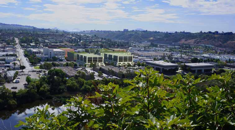
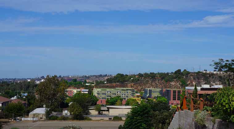
3 Project Location Grantville is centrally located in the heart of the San Diego region. It is sited in the Northeast corner of the Interchange of the I-8 and I-15 Freeways. Grantville is directly connected to Mission Valley, which is one of the most active regions of San Diego, with significant employment, shopping, and entertainment opportunities, including Qualcomm Stadium home to the San Diego Chargers NFL Football team. This region hosts over 155,000 jobs and is a major economic center in San Diego. In 2002, the San Diego Transit District completed the East Line Extension of the Light Rail Trolley to Grantville and to San Diego State University. Major Trolley Stops were constructed in Grantville and at the next stop, which is San Diego State University. In 2005, Grantville was approved as a State Redevelopment Project Area. It is now qualified to collect and commit funds for Public Infrastructure and Public/Private Investment. Site Plan/Location

4 Land use Patters The CenterPointe at Grantville Plan site is located in the path of several other large scale, high density multifamily development projects that have been built throughout the 1970 s and 1980 s. A few of these multifamily projects began as for-rent apartments and were later converted to forsale condominiums. Several of these existing projects are still for-rent apartments. These, along with a few newer apartment communities to the west in Mission Valley, provide the basis of comparable for the CenterPointe at Grantville Master Plan. NOTE: All of the surrounding multifamily projects are running at 95% occupancy levels. As seen by the development patterns, CenterPointe at Grantville will be the only true high-density, mixed-used use urban village in the area that combines ground floor retail and commercial all in one walkable and sustainable lifestyle community. This will give the CenterPointe at Grantville project a distinct competitive advantage to other residential projects in the area. High Density Multifamily (light Blue) Single Family Detached (Light Green) Commercial/Employment/Retail Zones (light Teal) Religious Facility and School (Yellow) Kaiser Hospital (Magenta) CenterPointe at Grantville Master Plan (Red) Map with a key that shows the land uses of the existing projects. Existing Multifamily Development Patterns

5 Access and Infrastructure One of the unique competitive advantages of the CenterPointe at Grantville Master Plan is its central location within the Central San Diego region. This allows residents of the Master Plan convenient and direct access to all the major employment clusters in San Diego County. Most of the aforementioned major bio-tech, hi-tech, clean tech, financial, military, and university based Industry Cluster jobs are within a minute drive of the Master Plan site. The centralized location of these job clusters is the foremost reason this portion of the San Diego region is more densely populated then other more outlying areas. The CenterPointe at Grantville Master Plan is located in the heart of this centralized and densely populated area at the convergence of major freeway networks that reach all portions of the county and provide quick access to all job base areas. Traffic Improvements As new development fills into the Grantville Area, new Traffic Improvements will be built to accommodate the higher density levels in the community. The improvements that will have the greatest benefit, and will therefore most likely occur first, are the following: Potential lane addition to Mission Gorge Road; Potential Re-alignment of Alvarado Canyon Road to the intersection of Fairmont Avenue; Potential widening of Mission Gorge Road to Mission Gorge Place; Significant re-construction of the I-8 bridge over Mission Gorge*. *The I-8 work is far out on the horizon and the redevelopment agency estimates the improvement cost to be $120M. Map with driving times in relation to the site. Access, Infrastructure, and Traffic
6 Entitlement Documents The following documents have been approved by the City of San Diego: 1. Vesting Tentative Map No Vesting Tentative Map (VTM) was approved by Resolution R by the City Council on May 15, See the Resolution for the VTM s Conditions of Approval. 2. Site Development Permit No Site Development Permit (SDP) was approved by Resolution R by the City Council on May 15, See SDP for the SDP s Conditions of Approval. 3. Supplemental Environmental Impact Report No The Supplemental Environmental Impact Report (SEIR) No was approved by the City Council by Resolution R by the City Council on May 15, Rezone Ordinance O The Rezone Ordinance O was Final Passed by the City Council on June 5, Community Plan Amendment Navajo Community Plan The Community Plan Amendment (CPA) to the Navajo Community Plan was Final Passed by the City Council on May 15, Mitigation, Monitoring and Reporting Program The Mitigation, Monitoring and Reporting Program (MMRP) was Final Passed by the City Council on May 15, There are various technical studies and reports that have been approved in conjunction with the approval of items 1 through 6 above. The items are: Traffic Impact Analysis The approved Traffic Impact Analysis (TIA) was included as Exhibit B of the approved Supplemental Environmental Impact Report (SEIR) Water Study The Water Study is titled Water Study for CenterPointe at Grantville Commercial/Residential Site, VTM #251403, WO #425043, PTS #80450, by Nasland Engineering, dated March 3, 2006, Amended April 24, Water Quality Technical Report The Water Quality Technical Report is titled Water Quality Technical Report for CenterPointe at Grantville Commercial/Residential Site, VTM #251403, IO # , PTS #178074, Dwg D, by Nasland Engineering, dated August 6, 2009, Amended December 9, 2009, Amended June 7, Amended July 6, Sewer Study The Sewer Study is titled Sewer Study for CenterPointe at Grantville Commercial/Residential Site, VTM #251403, WO # , PTS #80450, by Nasland Engineering dated February 23, 2006, Amended May 5, 2006, Amended July 7, Drainage Study (Hydrology) The Drainage Study is titled Drainage Study for CenterPointe at Grantville Commercial/Residential Site, IO # , PTS #178074, Dwg D, by Nasland Engineering, dated August 5, 2009, Amended December 7, Geo-technical Report The Geo-technical Report is titled Update Geo-technical Evaluation, CenterPointe at Grantville, by Ninyo & Moore, dated June 24, Further Required Plan Development and Approvals Grading and Public Improvement Plans Subsequent to the CenterPointe Project entitlement and report approvals by the City of San Diego, the Owner has pursued the preparation of the project s Improvement Plans (Grading, Water, Sewer and Storm Drain). All of this work is substantially complete and approved by the City; these plans are in the final MYLAR status with the City. Final Map Additionally, subsequent to the CenterPointe entitlement and report approvals by the City of San Diego, the Owner has pursued the preparation of the project s Final Map. The Final Map requires continued preparation and processing with the City; it is anticipated that it will require 6-months to complete this work. Building Drawings By intention, no work has been initiated for the design of the buildings. The buildings will need to have Construction Drawings prepared; they will need to be completed in conformance with the conditions of the Vesting Tentative Map and the Site Development Permit cited above. The Construction Drawings will need to be processed with the City of San Diego in order to obtain Building Permits. Entitlements and Processing
7 Build-Out Summary Due to the expiration of the leases and permitting schedule, the project can be broken out into two macro phases: Phase 1: Construction could begin on any of the lots (A,B,C,H or G) in the first phase (shown in red below) in approximately the 4th Quarter of 2013; with 272 multifamily units and 126,064 safe of office/retail space delivering sometime around the 2nd Quarter of 2015; KAISER Hospital/OFFICE Vander Ave. Existing Office Phase 2 Construction could begin on any of the lots in the second phase (shown in blue below) one year later, in approximately the 4th Quarter of 2014; with 316 multifamily units delivering by the 2nd Quarter of LOT Height (Floors): # Units: Office/Retail: Parking Spaces: A B C H ,264 s.f. 287 G- Adaptive Re-Use 4-54,800 s.f. 137 SUB TOTAL: ,064 s.f. 768 Fairnount Ave. Mission Gorge Rd. D E ,000 s.f. 194 F ,164 s.f. 107 SUB TOTAL: ,164 s.f. 490 PROJECT TOTAL: ,228 s.f. 1,258 Twain Ave. Phase 1 Start: 4th Quarter 2013 Phase 2 Start: 4th Quarter 2014 Development Build-Out Summary
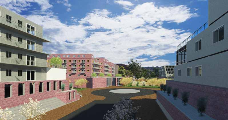
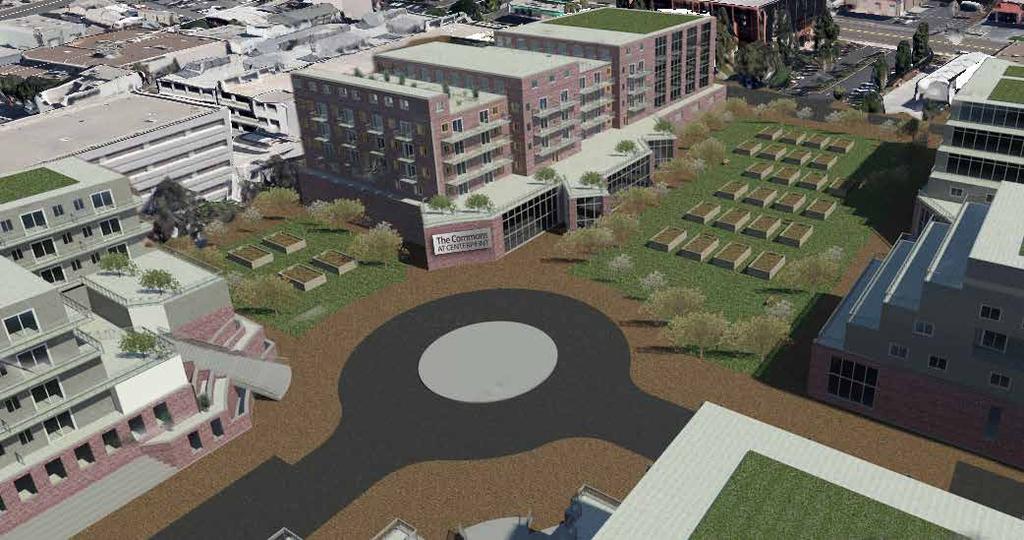
8 Renderings `
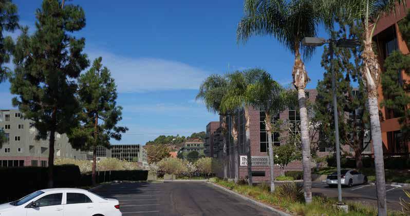
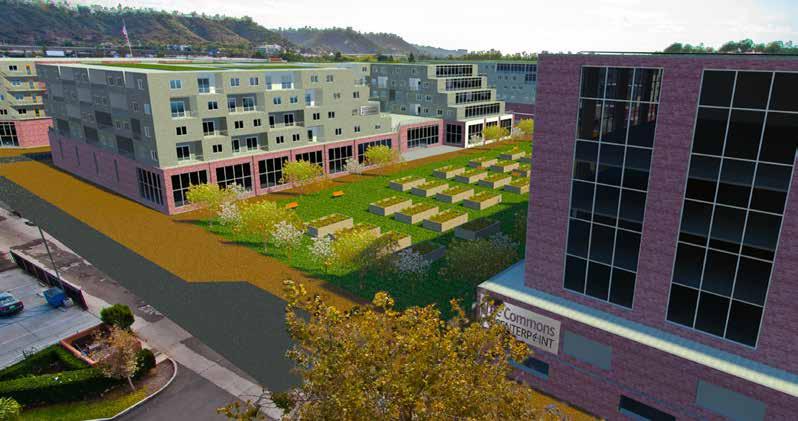
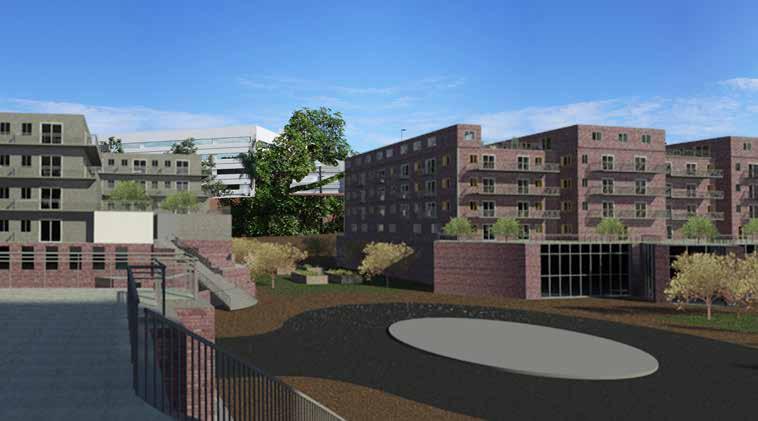
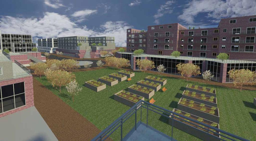
9 Renderings
10 Appendix The documents listed below can be downloaded at this link: A. Project Renderings B. Traffic Study C. Environmental Impact Report D. Remaining Cycle Issues E. Geotechnical Evaluation F. Rezone Ordinance G. Community Plan Amendment H. Final Site Development Permit and Resolution I. Mitigation Monitoring and Reporting Program J. Vesting Tentative Map Resolution K. Encroachment Maintenance & Removal Agreement/ Storm Water Maintenance Agreement L. Update Geotechnical Report M. Response to Update Geotechnical Report N. Approved Bond Estimate O. Grading and Improvement Plans (Multiple File Folder) P. Hydrology Study (Multiple File Folder) Q. Water Study R. Water Quality Technical Report S. Sewer Study T. Vesting Tentative Map U. Preliminary Title Report V. Assessor s Parcel Map W. Map Guarantee (First American Title) X. Clear Title Request Y. CoStar Office Report 2Q 2011 Z. CoStar Retail Report 2Q 2011 Za. London Group Market and Feasibility Report 2007 Zb. CentrePointe at Grantville Existing 2011 PL Forecast Zc. Mission Corporate Center Rent Roll Zd. Mission Industrial Park Rent Roll Ze. Mission Office Park Rent Roll Zf. Site and Area Photos Zg. Theoretical Development Schedule Appendix`
REZONING GUIDE. Zone Map Amendment (Rezoning) - Application. Rezoning Application Page 1 of 3. Return completed form to
 - Application. Rezoning Application Page 1 of 3. Return completed form to") Zone Map Amendment (Rezoning) - Application COMMUNITY PLANNING & DEVELOPMENT REZONING GUIDE Rezoning Application Page 1 of 3 PROPERTY OWNER INFORMATION* CHECK IF POINT OF CONTACT FOR APPLICATION Property
Zone Map Amendment (Rezoning) - Application COMMUNITY PLANNING & DEVELOPMENT REZONING GUIDE Rezoning Application Page 1 of 3 PROPERTY OWNER INFORMATION* CHECK IF POINT OF CONTACT FOR APPLICATION Property
Isabel Neighborhood Plan: Alternatives
 Isabel Neighborhood Plan: Alternatives Presented by: Lori Parks, Associate Planner February 2, 2015 Agenda 1. Background on BART to Livermore 2. Isabel Neighborhood Plan 3. Alternative Scenarios 4. General
EXHIBIT A. Tax Increment Reinvestment Zone No. 1 (Town Center) First Amended Project Plan 1
 First Amended Project Plan 1") EXHIBIT A Tax Increment Reinvestment Zone No. 1 (Town Center) First Amended Project Plan 1 1 As amended by Resolution No. 2008-02-001(TR1R) of the Tax Increment Reinvestment Zone No.1, and approved to
EXHIBIT A Tax Increment Reinvestment Zone No. 1 (Town Center) First Amended Project Plan 1 1 As amended by Resolution No. 2008-02-001(TR1R) of the Tax Increment Reinvestment Zone No.1, and approved to
LEED-ND 101: Practical Strategies for Achieving Sustainability Goals. Travis Parker Lakewood Planning Director
 LEED-ND 101: Practical Strategies for Achieving Sustainability Goals Travis Parker Lakewood Planning Director Metro Vision Idea Exchange Oct 11, 2012 West Corridor Stations West Corridor Overview West
Madison St. Oak Park. Request for Proposals. Village Owned Parcel Madison Street Oak Park, Illinois Reissued May 25, 2018.
 Madison St. Oak Park Village Owned Parcel 700-728 Madison Street Oak Park, Illinois Reissued May 25, 2018 Proposal Due, 2018 Date 3:00 pm 700-728 Madison Street including adjacent public alley and street
CITY OF COLWICH COMPREHENSIVE PLAN LAND USE LAND USE 1
 LAND USE LAND USE 1 WHAT YOU WILL FIND IN THIS CHAPTER: Discussion of today s conditions and tomorrow s projections Discussion of challenges and opportunities Discussion of the environmental quality goals,
KEIZER STATION PLAN INTRODUCTION
 KEIZER STATION PLAN INTRODUCTION Planning for this area began in 1987 when the Keizer Comprehensive Plan established the Chemawa Activity Center and McNary Activity Center. The first Chemawa Activity Center
Joint Study Session of the Sutter County. March 2, 2009
 Joint Study Session of the Sutter County Board of Supervisors and Planning Commission March 2, 2009 CURRENT APPLICATION General Plan Amendment Specific Plan Specific Plan Appendices Utility Plans Transit/AQ
This Review Is Divided Into Two Phases:
 Semiahmoo Town Centre Review The purpose of this review: To review the Semiahmoo Town Centre Concept Plan, originally approved in 1993, to ensure that this centre will continue to serve the needs of South
C. Westerly Creek Village & The Montview Corridor
 C. Westerly Creek Village & The VISION Community Vision When the goals of the city are achieved Westerly Creek Village, a distinctive community defined by Montview Boulevard and Westerly Creek, is a strong
SHEFFIELD PARK Paulding County, GA DRI #588
 SHEFFIELD PARK Paulding County, GA DRI #588 Supplemental Information for RDC s DRI (Form 2) Review August 16, 2004 Prepared for: Mr. David Howerin Coosa Valley RDC 1 Jackson Hill Drive Rome, GA 30161 P.O.
NEC of Central Avenue and Indian School Road
 NEC of Central Avenue and Indian School Road For this location, there are two applicable plans that provide guidance on development. The two plans include the Indian School Specific Plan (1991) and the
SYRINGA VALLEY SPECIFIC PLAN NARRATIVE
 SYRINGA VALLEY SPECIFIC PLAN NARRATIVE Introduction With this application, Pleasant Valley South LLC ( Pleasant Valley ) seeks the City of Boise s approval of a new Specific Plan Ordinance to be added
Staff Report to the North Ogden City Planning Commission
 Staff Report to the North Ogden City Planning Commission SYNOPSIS / APPLICATION INFORMATION Application Request: Concept review on a legislative application to rezone land located at approximately 1750
City Center Specific Plan Amendments And Background Report City of Richmond. PLANNING COMMISION FINAL DRAFT January, 2001
 City Center Specific Plan Amendments And Background Report City of Richmond PLANNING COMMISION FINAL DRAFT January, 2001 TABLE OF CONTENTS Page LIST OF TABLES... LIST OF FIGURES... INDEX... OVERVIEW...
MOUNT BAKER TOWN CENTER: THE 2014 REZONE AND TRANSIT ORIENTED DEVELOPMENT. By Talis Abolins
 MOUNT BAKER TOWN CENTER: THE 2014 REZONE AND TRANSIT ORIENTED DEVELOPMENT By Talis Abolins In 2014, the City of Seattle adopted Ordinance 124513, and created a transit oriented rezone over the area known
4 LAND USE DESIGNATIONS
 4 LAND USE DESIGNATIONS Chapter 4 describes the land use designations and densities that will implement the development vision for North Burlingame outlined in Chapter 3. Land use densities are described
Planning and Growth Management Committee. Chief Planner and Executive Director, City Planning Division. Pg12013 (File No NNY 34 OZ)
") 865 York Mills Road Official Plan Amendment Application Preliminary Report STAFF REPORT ACTION REQUIRED Date: February 28, 2012 To: From: Wards: Reference Number: Planning and Growth Management Committee
865 York Mills Road Official Plan Amendment Application Preliminary Report STAFF REPORT ACTION REQUIRED Date: February 28, 2012 To: From: Wards: Reference Number: Planning and Growth Management Committee
Staff Report and Recommendation
 Community Planning and Development Planning Services 201 W. Colfax Ave., Dept. 205 Denver, CO 80202 p: 720.865.2915 f: 720.865.3052 www.denvergov.org/cpd TO: City Council Neighborhoods and Planning Committee
RESOLUTION NO. R Refining the route, profile and stations for the Downtown Redmond Link Extension
 RESOLUTION NO. R2018-32 Refining the route, profile and stations for the Downtown Redmond Link Extension MEETING: DATE: TYPE OF ACTION: STAFF CONTACT: Capital Committee Board PROPOSED ACTION 09/13/2018
New Partners for Smart Growth Conference February 5, 2010
 Dan Stroh, Planning Director City of Bellevue Planning and Community Development Bellevue, WA New Partners for Smart Growth Conference February 5, 2010 Summary of Project Long-range plan update for Bel-Red
Westbound: A One-day Exploration of Growth
 Westbound: A One-day Exploration of Growth Frog Pond Area 2018 UGB Expansion Proposal June 13, 2018 Growing Out: UGB Asks Four cities submitted proposals to expand greater Portland s urban footprint by
DOMINION BOULEVARD CORRIDOR STUDY AND ECONOMIC DEVELOPMENT STRATEGIC PLAN A MODEL FOR CHESAPEAKE S FUTURE
 DOMINION BOULEVARD CORRIDOR STUDY AND ECONOMIC DEVELOPMENT STRATEGIC PLAN A MODEL FOR CHESAPEAKE S FUTURE Overview I. Draft Plan Process II. Draft Plan Overview a. Market Analysis b. Master Land Use Plan
Beatties Ford Road & Mt. Holly-Huntersville Road Small Area Plan
 Beatties Ford Road & Mt. Holly-Huntersville Road Small Area Plan Town of Huntersville October 2005 Town of Huntersville Planning Department 101 Huntersville Concord Road Post Office Box 664 Huntersville,
PROJECT DESCRIPTION. Providing a mix of housing options supporting a diversity of needs (800-1,600 sf 1-3 bd flats and Townhomes).
.") ROHNERT PARK Planned Development - Preliminary Application Project Site LOCATION MAP Project Site Rohnert Crossings is a acre mixed-use urban village proposed in the center of the city adjacent what will
ROHNERT PARK Planned Development - Preliminary Application Project Site LOCATION MAP Project Site Rohnert Crossings is a acre mixed-use urban village proposed in the center of the city adjacent what will
Mill Woods Town Centre Proposed Rezoning LDA
 Mill Woods Town Centre Proposed Rezoning LDA15 0649 The City of Edmonton has received an application for rezoning and an amendment to the Mill Woods Station Area Redevelopment Plan (ARP) for the Mill Woods
FOR SALE Roosevelt Way Seattle, WA Features. Michael Todd
 FOR SALE FOR MORE INFORMATION PLEASE CONTACT: 5048 Roosevelt Way Seattle, WA 98105 Features mtodd@ westlakeassociates.com PRICE: $1,795,000 UNITS: 3 SIZE: 6,450 SF ZONE: NC2 40 CAP: 4.5 GRM: 18.1 + Transit
City of Grande Prairie Development Services Department
 City of Grande Prairie Development Services Department ROYAL OAKS NORTH OUTLINE PLAN OP-07-03 NW 35-71-6 W6M May 7, 2007 Royal Oaks North Outline Plan TABLE OF CONTENTS 1.0 INTRODUCTION........ 3 1.1 Purpose
Secrest Short Cut and Monroe Expressway Small Area Plan AUGUST 29, 2018
 Secrest Short Cut and Monroe Expressway Small Area Plan AUGUST 29, 2018 Background and Process Monroe Expressway will be open by the end of 2018 Union County and Indian Trail identified a need to revisit
6 Growth Management Challenges and Opportunities
 6 Growth Management Challenges and Opportunities The Town has established a goal of attaining a 50% participation rate with respect to employment opportunities versus residential population. The Town s
Existing Conditions Summary (Draft for Review)
") Existing Conditions Summary (Draft for Review) Prepared by March 16, 2015 Bird s-eye-view of Norwalk in 1899 (Cropped) Existing Conditions Summary (Draft for Review) March 16, 2015 Table of Contents 1.
Existing Conditions Summary (Draft for Review) Prepared by March 16, 2015 Bird s-eye-view of Norwalk in 1899 (Cropped) Existing Conditions Summary (Draft for Review) March 16, 2015 Table of Contents 1.
MALL REVITALIZATION CASE STUDIES
 MALL REVITALIZATION CASE STUDIES DECEMBER 9, 2012 MALL REVITALIZATION OVERVIEW Introduction Sample Case Studies prepared for Lacey Woodland District Steering Committee as it considers strategies to revitalize
CITY OF ALAMEDA PLANNING BOARD Draft RESOLUTION
 CITY OF ALAMEDA PLANNING BOARD Draft RESOLUTION A RESOLUTION OF THE PLANNING BOARD OF THE CITY OF ALAMEDA APPROVING DESIGN REVIEW AND DEVELOPMENT PLAN AMENDMENT APPLICATION PLN13-0157 TO CONSTRUCT ELEVEN
Pantops Master Plan Update 2018
 Pantops Master Plan Update 2018 Focus Area Topic Meeting #1 Land Use & Development Area Boundary North of I-64 February 26, 2018 Pantops Master Plan Update 2018 Focus Area Public Meetings: Kickoff Meeting
D-O LRT Zoning Discussion. Chapel Hill Boards & Commissions October 16, 2017
 D-O LRT Zoning Discussion Chapel Hill Boards & Commissions October 16, 2017 Update on Overall D-O LRT Station Area Initiative Objectives Design and educate on principles of Good Transit-Oriented Development
3. Project Description
 3.1 PROJECT LOCATION The Platinum Triangle (herein after also referred to as the Project Area ) is located at the confluence of the Interstate 5 (I-5 Freeway) and the State Route 57 (SR-57 Freeway), in
S o u t h C e n t r a l O u t l i n e P l a n. Leduc Business Park. North Leduc Industrial Area Structure Plan C it y of Led u c.
 Leduc Business Park North Leduc Industrial Area Structure Plan C it y of Led u c Prepared for Farm Air Properties Inc. January, 2007 Table of Contents Page Number 1.0 Purpose of Plan and Definition of
REZONING GUIDE. Zone Map Amendment (Rezoning) - Application. Rezoning Application Page 1 of 3. Return completed form to
 - Application. Rezoning Application Page 1 of 3. Return completed form to") Zone Map Amendment (Rezoning) - Application COMMUNITY PLANNING & DEVELOPMENT REZONING GUIDE Rezoning Application Page 1 of 3 PROPERTY OWNER INFORMATION* CHECK IF POINT OF CONTACT FOR APPLICATION Property
Zone Map Amendment (Rezoning) - Application COMMUNITY PLANNING & DEVELOPMENT REZONING GUIDE Rezoning Application Page 1 of 3 PROPERTY OWNER INFORMATION* CHECK IF POINT OF CONTACT FOR APPLICATION Property
Jeff Brasel, Senior Planner, Community Planning and Development Analiese Hock, Senior Planner, Community Planning and Development
 To: From: Jeff Brasel, Senior Planner, Community Planning and Development Analiese Hock, Senior Planner, Community Planning and Development Ascendant Capital Partners Date: February 21, 2017 Re: Summary
Bourne Downtown Site Planning
 Prepared for: The Town of Bourne, MA In Cooperation with: Bourne Financial Development Corporation Prepared by:, Inc. June 24, 2009 Table of Contents Introduction and Summary... 1 Site Existing Conditions...
Metro. Activity Center Design Guidelines. Recommendations For Developing Focused, Mixed-Use Commercial/Residential Centers
 Metro Activity Center Design Guidelines Recommendations For Developing Focused, Mixed-Use Commercial/Residential Centers Metro Activity Centers What is a MAC? Legacy, the adopted guide for the future growth
Today Land & People. Northeast Nampa Gateway District. Employment. Land Use Characteristics. Demographics. Current Zoning
 Today Land & People Employment Major employers include Saint Alphonsus, the College of Western Idaho, the Auto Mall, Sorrento Lactalis and Walmart. 3,004 jobs in 2010 (COMPASS-CIM 2040 TAZ data) 4,345
178 Carruthers Properties Inc.
 178 Carruthers Properties Inc. Planning Rationale for 178 Carruthers Avenue Site Plan Control Application June 2014 Table of Contents 1.0 Introduction 2.0 Overview of Subject Property 3.0 Current Zoning
Gold Line Bus Rapid Transit Transit Oriented Development (BRTOD) Helmo Station Area Plan
 Helmo Station Area Plan") Appendix F Gold Line Bus Rapid Transit Transit Oriented Development (BRTOD) Helmo Station Area Plan Introduction and Purpose of the Plan The Gold Line Bus Rapid Transit facility is an eleven-mile dedicated
Appendix F Gold Line Bus Rapid Transit Transit Oriented Development (BRTOD) Helmo Station Area Plan Introduction and Purpose of the Plan The Gold Line Bus Rapid Transit facility is an eleven-mile dedicated
Planning Commission Staff Report June 5, 2008
 Owner/Applicant Taylor Village Sacramento Investments Partners, LP c/o Kim Whitney 1792 Tribute Road #270 Sacramento, CA 95815 Staff Recommendation Planning Commission Staff Report Project: File: Request:
Peppertree Business Park
 12.55 Net Acres Corporate/Institution Development Site PEPPERTREE BUSINESS PARK IS A UNIQUELY BEAUTIFUL MASTER PLANNED DEVELOPMENT SITE NESTLED AT THE FOOT OF THE SIMI HILLS WITH MEIER CREEK STREAMBED
Urban Planning and Land Use
 Urban Planning and Land Use 701 North 7 th Street, Room 423 Phone: (913) 573-5750 Kansas City, Kansas 66101 Fax: (913) 573-5796 Email: planninginfo@wycokck.org www.wycokck.org/planning To: From: City Planning
Town of Portola Valley General Plan. Nathhorst Triangle Area Plan
 Town of Portola Valley General Plan Amended December 10, 1997 Table of Contents Introduction... 1 Planning Area... 1 Objectives... 2 Principles... 2 Standards... 4 Description... 4 Community Commercial...
City Of Sparks Planning Commission Item
 Page 1 of 12 City Of Sparks Planning Commission Item Meeting Date: May17, 2012 Subject: PCN12009, Public Hearing, Consideration and possible action on a Master Plan Amendment and Rezoning request to change
PLANNING COMMISSION RESOLUTION NO GREEN LINE MIXED USE SPECIFIC PLAN
 PLANNING COMMISSION RESOLUTION NO. 2017-16 GREEN LINE MIXED USE SPECIFIC PLAN A RESOLUTION OF THE PLANNING COMMISSION OF THE CITY OF HAWTHORNE RECOMMENDING THAT THE CITY COUNCIL OF THE CITY OF HAWTHORNE,
CITY OF NORCROSS LILLIAN WEBB PARK REDEVELOPMENT AREAS
 7/2/2016 CITY OF NORCROSS LILLIAN WEBB PARK REDEVELOPMENT AREAS 2016 Potential Development Around Lillian Webb Park The Lillian Webb Park Development Project is located north of Buford Highway; east of
PSRC REVIEW REPORT & CERTIFICATION RECOMMENDATION
 PSRC REVIEW REPORT & CERTIFICATION RECOMMENDATION KITSAP COUNTY COUNTYWIDE PLANNING POLICIES July 2, 2012 BACKGROUND A major emphasis of the Washington State Growth Management Act (GMA) is the need to
City of Farmington. Downtown Plan. Amendment to the 1998 Master Plan Adopted October 11, 2004
 City of Farmington Amendment to the 1998 Master Plan Adopted October 11, 2004 Introduction Planning Background 1 Scope and Components of the Plan Amendment 2 Concept Introduction 3 Plan Concepts 3 Conceptual
PLANNING AND ZONING COMMISSION AGENDA MEMORANDUM
 PLANNING AND ZONING COMMISSION AGENDA MEMORANDUM City and County of Broomfield, Colorado To: Planning and Zoning Commission From: John Hilgers, Planning Director Anna Bertanzetti, Principal Planner Meeting
Sewanee Village + Request for Builder/Developer Proposals
 Sewanee Village + Request for Builder/Developer Proposals Contact: Frank X. Gladu Special Assistant to the Vice Chancellor University of the South 735 University Ave Version 3 Sewanee TN 37383 Released:
2.0 THE PLATINUM TRIANGLE VISION
 2.0 THE PLATINUM TRIANGLE VISION The envisions an exciting future for the area surrounding Angel Stadium of Anaheim, the Honda Center and The Grove of Anaheim. 2.1 Planning Principles In order to further
Approved: CITY OF ARDEN HILLS, MINNESOTA PLANNING COMMISSION WEDNESDAY, AUGUST 5, :30 P.M. - ARDEN HILLS CITY HALL
 Approved: CITY OF ARDEN HILLS, MINNESOTA PLANNING COMMISSION WEDNESDAY, AUGUST 5, 2015 6:30 P.M. - ARDEN HILLS CITY HALL PLANNING CASES A. Planning Case 15-016; Final Planned Unit Development Arden Plaza;
City of Fort Lauderdale UPTOWN URBAN VILLAGE. Public Workshop December 7, 2016
 Public Workshop December 7, 2016 Workshop Agenda Introductions Project Presentation o o o History Project Scope/Timeline Character of Study Area o o o o Land Use Public Realm/Pedestrian Mobility Multimodal
Santa Monica Chamber of Commerce DSP Subcommittee s DSP EIR Scoping Comments and Preliminary Comments on the DSP Framework
 Santa Monica Chamber of Commerce DSP Subcommittee s DSP EIR Scoping Comments and Preliminary Comments on the DSP Framework The Chamber of Commerce s DSP Subcommittee s comments on the scope of the DSP
TUSTIN RED HILL DEVELOPMENT TUSTIN CITY COUNCIL WORKSHOP
 TUSTIN RED HILL DEVELOPMENT TUSTIN CITY COUNCIL WORKSHOP 7-6-15 CONTEXT MAP PREVIOUS CHURCH AND ADJACENT RETAIL SITE EXISTING RETAIL CENTER SITE CONDITIONS PREVIOUS SITE CONDITIONS PREVIOUSLY APPROVED
CHAPTER 1. Ms. Guajardo s Class - Central Elementary CH 1 1
 INTRODUCTION CHAPTER 1 Ms. Guajardo s Class - Central Elementary CH 1 1 1.1 SETTING South Centre City is a linear corridor south of Downtown Escondido paralleling Centre City Parkway and South Escondido
A. WHAT IS A GENERAL PLAN?
 I. Introduction A. WHAT IS A GENERAL PLAN? A general plan is the planning guideline for the future of a city. It contains goals and policies which regulate urban development, the protection of the natural
SUNSET CORRIDOR LAND. The property is now available and ready for corporate utilization, development or investment.
 SUNSET CORRIDOR LAND The property is now available and ready for corporate utilization, development or investment. This 275-acre site is now available and ready to develop. Just off US 26, this west Sunset
Description of Preferred Alternative
 Chapter 2 Description of Preferred Alternative 2.1 Introduction This chapter of the programmatic Sammamish Town Center Sub-area Plan Final EIS provides a more detailed description of the Preferred Alternative
CHAPTER 20: NEIGHBORHOOD J
 CHAPTER 20: NEIGHBORHOOD J INTERSTATE 43 & RACINE QUARRIES Revisions approved by Council 11/15/16 via Ordinance #2579 PLANNING CONTEXT The Highway Interstate 43 & Racine Avenue interchange offers numerous
141 GEORGE STREET PLANNING RATIONALE
 141 GEORGE STREET PLANNING RATIONALE MINOR ZONING BY-LAW AMENDMENT NOVEMBER 2, 2016 PLANNING RATIONALE 223 McLeod Street Ottawa, ON K2P 0Z8 613.730.5709 fotenn.com INTRODUCTION FOTENN Consultants is acting
Figure 1- Site Plan Concept
 Figure 1- Site Plan Concept Parking will be provided underground on three levels at rate of 1.0 space/ unit; this rate includes all visitors parking. MMM Group has prepared a parking assessment (April,
Planning Commission April 4, 2013 BOCC Workshop Page 1
 Planning Commission April 4, 2013 BOCC Workshop Page 1 Planning Commission April 4, 2013 BOCC Workshop Page 2 Planning Commission April 4, 2013 BOCC Workshop Page 3 Planning Commission April 4, 2013 BOCC
General Location Annex, Rezone & Preliminary Plat Lansdowne Addition, Unit Three
 NEWFOUNDLAND I-5 Agricultural District Subject Site SUNDANCE ANDERSON Single Family Residential CHRISTY PUD Agricultural District Highway Business General Location Annex, Rezone & Preliminary Plat Lansdowne
Taming Tysons Corner Transforming the Quintessential Edge City
 Taming Tysons Corner Transforming the Quintessential Edge City Transit is the greatest catalyst for change at Tysons, but how do we take advantage of this billion-dollar investment? If transit is built
Town Center (part of the Comprehensive Plan)
") Town Center (part of the Comprehensive Plan) Mercer Island Town Center Looking North (2014) In 1994, a year-long process culminated in a set of design guidelines and code requirements for the Town Center
Town Center (part of the Comprehensive Plan) Mercer Island Town Center Looking North (2014) In 1994, a year-long process culminated in a set of design guidelines and code requirements for the Town Center
FOR SALE Bannister /- Acres Residential/Multifamily Urban Infill
 FOR SALE Bannister -- 32.0 +/- Acres Residential/Multifamily Urban Infill Anticipate 15,000 new employees! Adjacent to huge Bannister Urban Redevelopment area, near Cerner Innovation Campus, Oxford on
Urban Renewal Proposal
 Urban Renewal Proposal South Nevada Avenue & South Tejon Street June 24, 2015 After Eight (8) years of exhaustive efforts by a number of local developers, the time has finally come for the City of Colorado
SOUTH NATOMAS COMMUNITY PLAN
 SOUTH NATOMAS Community Plan Part Three : COMMUNITY PLAN AREAS AND SPECIAL STUDY AREAS SACRAMENTO 2030 GENERAL PLAN Contents Community Location... 3-SN-3 Community Vision... 3-SN-4 Community Profile...
Living in Albemarle County s Urban Places
 Living in Albemarle County s Urban Places ALBEMARLE COUNTY, VIRGINIA A Closer Look at Albemarle s Approach to Managing Growth and Creating Quality Urban Environments www.albemarle.org Page 2 Living in
The Private Role in a Public-Private Partnership. Ask Me Anything Conference May 30, 2018
 The Private Role in a Public-Private Partnership Ask Me Anything Conference May 30, 2018 1 Thoughts to Share Today Schmit+Associates Essential Elements of a P3 Community Vision Market Demand Economic Viability
Behnke Ranch Property, Pasco County: Master Plan Development Approach
 February 24, 2014 , Pasco County: Master Plan Development Approach Location & Program The (Legacy PUD) is located in southwest Pasco County along State Road 54 approximately 1.5 miles west of the Suncoast
International Blvd. TOD Plan Public Workshop #1
 International Blvd. TOD Plan Public Workshop #1 Add photos or project images September 21 and 22, 2010 Workshop Purpose Introduce the public to the Project Review and discuss the existing conditions analysis
What. - Civic anchors including a park and an updated library branch
 SUMMARY What Master Plan aimed at delivering - A walkable, mixed-use downtown in the heart of University City anchored by UNC Charlotte and University Research Park - Civic anchors including a park and
Northwest Rail Corridor and US 36 BRT Development Oriented Transit Analysis 4.4 STATION AREA FINDINGS
 4.4 STATION AREA FINDINGS Each station is different, and each one requires a separate set of recommendations based on the vision for the site. This section outlines an initial TOD strategy and recommendations
CHAPTER 2 SUMMARY 1. PROJECT SUMMARY DATA
 CHAPTER 2 SUMMARY This is an Initial Study format used to determine, pursuant to CEQA Guidelines Section 15177, whether a project 1) is within the scope of a Master EIR (MEIR), 2) may result in additional
ADMINISTRATION RECOMMENDATION(S) 2018 January 25. That Calgary Planning Commission recommend APPROVAL of the proposed Land Use Amendment.
 2018 January 25. That Calgary Planning Commission recommend APPROVAL of the proposed Land Use Amendment.") Page 1 of 9 EXECUTIVE SUMMARY This land use amendment proposes to redesignate a parcel from DC Direct Control District to Multi-Residential Contextual Grade-Oriented (M-CG) District to allow for multi-residential
Page 1 of 9 EXECUTIVE SUMMARY This land use amendment proposes to redesignate a parcel from DC Direct Control District to Multi-Residential Contextual Grade-Oriented (M-CG) District to allow for multi-residential
Sustainable Development Call for Projects
 Sustainable Development Call for Projects 2005-2006 Infrastructure Project Examples *Note: This list is not all inclusive, but a sampling of the types of projects that were awarded funds. 137 Projects
CHARLES PUTMAN CHARLES PUTMAN AND ASSOCIATES, INC
 MEMORANDUM CHARLES PUTMAN & ASSOCIATES, INC. LAND DEVELOPMENT CONSULTANTS PLANNING ZONING PERMITTING 4722 NW Boca Raton Boulevard, Suite C-106 Boca Raton, Florida 33431 Phone: 561/994-6411 FAX: 561/994-0447
THEMES, VISION, + PRINCIPLES
 CHAPTER 2: THEMES, VISION, + PRINCIPLES This page intentionally left blank. 20 VISION DRAFT AUGUST 2018 2 2 THEMES, VISION, + GUIDING PRINCIPLES The Key Themes, Vision, and Guiding Principles presented
TIRZ 17/Redevelopment Authority Capital Improvements Plan Projects
 Gessner Widening: T-1701 What: Widen the road from a six-lane divided boulevard to an eight-lane divided boulevard street section, increase turn lanes, update traffic signal system, improve drainage by
Corridor Vision. 1Pursue Minnehaha-Hiawatha Community Works Project. Mission of Hennepin County Community Works Program
 1Pursue Minnehaha-Hiawatha Community Works Project Minnehaha-Hiawatha Community Works is a project within the Hennepin Community Works (HCW) program. The mission of the HCW program is to enhance how the
STAFF REPORT INTRODUCTION
 STAFF REPORT SUBJECT: DATE: Application for Master Land Use Plan Modification Southern Village Master Land Use Plan (Project No. 12-101) May 22, 2013 (Community Design Commission) May 23, 2013 (Transportation
Woodburn Comprehensive Plan Growth Management Goals and Policies
 Goal Woodburn Comprehensive Plan Growth Management Goals and Policies G-1. The City's goal is to manage growth in a balanced, orderly and efficient manner, consistent with the City s coordinated population
Implementation Guide Comprehensive Plan City of Allen
 Implementation Guide 2030 Comprehensive Plan City of Allen DRAFT 2015 Implementation Guide Allen 2030 Comprehensive Plan INTRODUCTION The Comprehensive Plan serves as a guide for the growth and development
DRAFT Land Use Chapter
 Stevens Creek Urban Village DRAFT 1 18 17 Land Use Chapter INTRODUCTION This Land Use Chapter describes how the Stevens Creek Urban Village will accommodate the growth that is planned for it in the Envision
LAND USE AMENDMENT CORNERSTONE (WARD 3) 60 STREET NE AND COUNTRY HILLS BOULEVARD NE MAP 26NE BYLAW 22D2017
 60 STREET NE AND COUNTRY HILLS BOULEVARD NE MAP 26NE BYLAW 22D2017") Page 1 of 14 EXECUTIVE SUMMARY This Land Use Amendment application covers an area of 43.76 hectares ± (108.14 acres ±) located in northeast Calgary, bound by Country Hills Boulevard NE to the south and
Page 1 of 14 EXECUTIVE SUMMARY This Land Use Amendment application covers an area of 43.76 hectares ± (108.14 acres ±) located in northeast Calgary, bound by Country Hills Boulevard NE to the south and
Seneca Meadows. Block 4 Locate office, technology, and medical development adjacent to I Screen views of garage structures from I-270.
 Seneca Meadows Seneca Meadows has an industrial park in its southern end and a mixed-use employment area planned for the north end. The district benefits from extensive I-270 visibility, stream valley
DRAFT PLAN PRESENTATION
 DRAFT PLAN PRESENTATION 1.23.2018 AGENDA Process Project Schedule Results from Visioning Workshop Draft Plan Highlights Concept Plans Feedback Next Steps PROJECT SCHEDULE KICK-OFF WORKSHOP August 29 th
Right-of-Way Acquisitions and Relocations Technical Memorandum
 Right-of-Way Acquisitions and Relocations Technical Memorandum Southeast Extension Project Lincoln Station to RidgeGate Parkway Prepared for: Federal Transit Administration Prepared by: Denver Regional
LAND USE OVERVIEW WHAT YOU WILL FIND IN THIS CHAPTER
 LAND USE WHAT YOU WILL FIND IN THIS CHAPTER Information about the City s expected population and employment growth. Description and capacity of existing and future land use designations. Policies that
West Broadway Transit Study Initial Screening of Alternatives Memo
 West Broadway Transit Study Initial Screening of Alternatives Memo 5/22/2015 Prepared by the SRF Consulting Group Team for Table of Contents Purpose... 1 Methodology... 1 Screening... 5 Screening Criteria...
AWH REPORT OF THE PLANNING AND DEVELOPMENT DEPARTMENT FOR APPLICATION FOR REZONING ORDINANCE TO PLANNED UNIT DEVELOPMENT
 AWH REPORT OF THE PLANNING AND DEVELOPMENT DEPARTMENT FOR APPLICATION FOR REZONING ORDINANCE TO PLANNED UNIT DEVELOPMENT MAY 8, 2014 The Planning and Development Department hereby forwards to the Planning
Rezoning Petition Pre-Hearing Staff Analysis September 17, 2018
 Rezoning Petition 2018-065 Pre-Hearing Staff Analysis September 17, 2018 REQUEST Current Zoning: NS (neighborhood services) Proposed Zoning: NS SPA (neighborhood services, site plan amendment) with five-year
The petition proposes to renovate two existing buildings in order to allow a mix of uses as permitted in MUDD (mixed use development).
.") Rezoning Petition 2017-156 Pre-Hearing Staff Analysis December 18, 2017 REQUEST Current Zoning: I-2 (general industrial) Proposed Zoning: MUDD-O (mixed use development, optional) with five-year vested
Rezoning Petition 2017-156 Pre-Hearing Staff Analysis December 18, 2017 REQUEST Current Zoning: I-2 (general industrial) Proposed Zoning: MUDD-O (mixed use development, optional) with five-year vested