Urban Design Guidelines
|
|
|
- Britney Floyd
- 5 years ago
- Views:
Transcription
1 Urban Design Guidelines These Urban Design Guidelines comprise the Key Design Objectives below, the Roads Design Guidelines overleaf and Neighbourhood Framework Plans. Together with Section 3: Urban Design Strategy and Section 4: Accessibility and Movement Strategy they will inform the planning, design and assessment of new development in Gorey Town and its Environs. Key Design Objectives Character New development must respond positively to the unique sense of place of the town, such as its unique planned market town structure and its surrounding topography and rural landscape. New development should add quality to the town and enhance its urban and landscape structure. Coherence Development in Gorey must contribute to its urban and landscape quality and coherence. This will be achieved by making and improving connections and interfaces between developments. The landscape and urban structure of areas of poor coherence should be addressed by public space improvements and, where appropriate, redevelopment. Where appropriate this coherence can be achieved by new open spaces or by upgrading and/or reconfiguring existing areas of open space and left-over spaces between adjoining developments. Connectivity and Permeability All new developments should provide for optimum levels of connectivity and permeability, particularly for pedestrians and cyclists, through careful consideration of layout and design. In general, each street or road in a new development should lead to another street or road. Existing areas with low levels of connectivity and permeability will be considered for retrofitting for new connections and comprehensive public space improvements in consultation with the local community. The priority will be for safe and attractive pedestrian and cyclist routes which are well overlooked and also provide for new facilities (play and passive recreation) for local residents and the community. Locations of poor connectivity are identified in the individual Neighbourhood Framework Plans (NFPs). Continuity and enclosure New streets and spaces should be continuously and adequately enclosed by building frontages and landscape. Existing continuity and enclosure should be maintained where it exists and opportunities to address weaknesses should be realised through infill development or redevelopment. Scale In the town centre building scale should reflect the established range of building heights. In new areas building scale should reflect the new urban structure of routes and landscape, with greater scale focused on the main avenues and focal spaces and lower scale on the secondary streets and spaces. Opportunities for increased building height will be considered where they make a clear contribution to the legibility and character of the town. Landscape New development should incorporate existing, significant landscape features and provide a coherent and distinctive new landscape structure as an integral and reinforcing part of the new urban structure. New landscape and open space corridors and hubs must connect to surrounding landscape features and be designed so as to be functional, safe and attractive. The watercourses of the town must be rehabilitated to provide important corridors for amenity, biodiversity, local access and water management. The public domain in the town centre will be upgraded as part of a new public realm plan to provide a hub for the open space network of the town. Adaptability The physical adaptability of the town centre, particularly its existing fine urban grain and robust urban blocks, should be retained. Adaptability in new areas should be achieved by providing robust urban blocks in which different building typologies can be achieved. Adaptable building typologies should also be considered to encourage variety of use and live-work opportunities, particularly in the town centre and at the focal spaces of new areas. Diversity Diversity of uses and activities is essential in securing the vitality and viability of the town. New development should contribute to an expansion of the range of uses and activities in the town. It should also ensure a mix of household types and tenures in new areas (see Section 2 Housing). The diversity of existing areas should be retained and expanded by protecting the rich mix of uses of the town centre and attracting new uses and activities to streets and spaces. Building style and materials Building style should be based on a proper consideration of the uniqueness and urban qualities of Gorey. Contemporary, vernacular or other styles should be compatible with existing building styles and the character and quality of the streetscape. Careful consideration should be given to articulating larger buildings and roof forms in the town centre. In all cases materials in new development should reflect local and regional materials and finishes and they should be durable and low maintenance. Urban Blocks Urban blocks are one of the basic components of the built environment. Although the planning and design of urban blocks has been neglected in the many developments in the past, in recent years there has been a recognition that proper block layout and design is fundamental to good urban design and successful places. Urban blocks are the basic development parcels that remain once open space, streets and footpaths and other public spaces have been provided. Urban blocks need to be sized and shaped to accommodate development of different uses and types. Urban blocks for residential areas, for example, tend to be smaller than urban blocks for industrial areas, where building and spaces are larger. Blocks also need to be laid out so that they take account of the local street network, topography and other features. They must also allow for good movement around them, to ensure that people have ease of movement through an area (permeability). If blocks are too large, inefficient use of urban land can occur. If they are too small, problems such as lack of floorspace, private open space, car parking and issues such as overlooking and poor access to sunlight, and daylight can occur. As a result, residential blocks require careful design. If the design and layout is appropriate and robust, then blocks can be developed in one go or in stages, using single or multiple building types and uses. 1


2 The perimeter block provides the greatest flexibility of urban block types. It provides coherent frontage to streets and spaces and it provides a clear distinction between public and private spaces. Figure 2 shows some of the main characteristic of a residential perimeter block. Design Speed DMURS Table 4.1 illustrates the broader application of design speeds according to context and function. Designers should refer to this table when designing urban streets and urban roads to align speed limits, design speeds and road function. When applying these limits designers must also consider how effectively they can be implemented, as the introduction of more moderate and/or lower speed limits out of context and/or without associated speed reduction measures may not succeed. DMURS Table 4.1: Design speed selection matrix indicating the links between place, movement and speed that need to be taken into account in order to achieve effective and balanced design solutions Main Streets and Roads Roads Design Guidelines The route concept set out in Section 3: Urban Design Strategy establishes the hierarchy of routes of different role and type in the plan area as follows: Main streets and roads Country roads/green routes Local streets and roads The route concept is important in that it is a key element of the urban structure of Gorey which informs not only movement, but also building type and density, landscape and land use. The purpose of these guidelines is to provide for a coherent design of new streets and roads and the improvement of existing routes to achieve a wider range of urban design and planning objectives and to contribute to greater quality and coherence of the town. The planning and design of all streets and roads in the plan area should comply with the objectives and guidelines included in the Design Manual for Urban Roads and Streets 2013 (DMURS). As outlined in Section the main streets and roads are the highest level routes within the street and road hierarchy of the town. This typology is diverse as it includes existing routes and planned new avenues connecting the local community spaces (as shown in the NFPs). Careful design of the new avenues will be required to achieve good movement characteristics, along with active frontage. Indicative sections and plans for these road types are included in Figures 26 and 27 below. DMURS provides guidance on the detailed design of radii, carriageway width, surfaces, visibility and splays, alignment, curvature and deflections and parking. In particular, careful consideration must be given to junction design. All junction must meet DMURS standards and there will be a presumption against roundabouts and in favour of standard junctions (either signalised, priority or uncontrolled). Existing large-scale roundabouts may, where necessary, be retrofitted or replaced by standard junctions along the existing main routes in the town, to achieve better provision for cyclist and pedestrians and to provide for the redevelopment of key corner locations. Developments requiring direct access or the intensification of existing accesses onto the Regional Road Network will be carefully considered in accordance with the relevant objectives and development management standards in the County Development Plan. 2


3 Table 1 - Main Street and Roads Design Objectives Country Roads 1. To provide high levels of access between the different parts of the town and, in particular, between the town centre and surrounding areas. 3. To ensure high levels of pedestrian and cycle movement and the inclusion of high quality dedicated facilities. 5. To provide for active streets and road frontage with opportunities for direct access and on-street car parking. 7. To provide for a distinctive landscape character and function, in particular secondary enclosure through measures such as tree lines, swales and margins. 9. To prepare an integrated urban design framework for the Main Streets and Roads to address in detail the preservation of the landscape and biodiversity, a coherent approach to redesign and re-alignment, redevelopment of the frontage and new cycle and pedestrian facilities. 2. To provide high levels of access to the main areas and local community spaces with the character areas. 4. To minimise severance caused by traffic movement by careful design and regular and frequent pedestrian and cycle crossings. 6. To provide for increase scale and continuity of street frontage, through the integration of different housing typologies such as apartments, townhouses and duplexes. 8. To consider opportunities for nonresidential and commercial use along the main streets and roads. These may be those already established or new opportunities at the new community spaces and at key intersection along the new avenues. 10. Developments requiring new accesses or the intensification of existing access onto the Regional Roads Network must comply with the relevant section and objectives in the Wexford County Development Plan (and any future Plan). As outlined in Section Gorey s existing country roads, such as the Hollyfort road, Fort road, Ballytegan road and Clonattin road, provide important radial connections from the surrounding and suburban areas to the town centre. They are also important access routes for many existing developments. Careful design of the country roads/green routes will be required to achieve good movement characteristics, along with active frontage.. Indicative sections and plans for this road type are included in Figure 28 below. DMURS provides detailed guidance on the detailed design of radii, carriageway width, surfaces, junction design, visibility and splays, alignment and curvature and deflections and parking. The emphasis, where possible, should be on improving rather than significantly realigning or widening the existing country road. Additional pedestrian and cycle facilities should be provided behind the retained hedgerow and tree line. Visibility and splay distances at new junctions must be carefully considered to minimise the impact on the existing hedgerow and tree line. 1. To provide good levels of access between the town centre and surrounding areas. 3. To ensure high levels of pedestrian and cycle movement and the inclusion of high quality dedicated facilities within a safe and high quality landscape. 5. To provide for an attractive setting for residential or commercial frontage which is suited to a range of different housing typologies including apartments, townhouses and duplexes. 7. To prepare an integrated urban design framework for the approach roads to the town to address in detail the preservation of the landscape and biodiversity, a coherent approach to redesign and realignment, redevelopment of the frontage and new cycle and pedestrian facilities Table 2 - Country Roads Design Objectives 2. To provide direct access and connection to the new avenues. 4. To provide for retained landscape (trees and hedgerows and other features) to the county road with a secondary building frontage recessed behind the retained tree and hedgerow line. 6. To provide for local water management measures, where appropriate, including swales and margins. 3


4 Table 3 - Local Streets and Roads Design Objectives 1. To provide controlled levels of local access within locals areas and developments and good connection to local community spaces and landscape. 3. To include appropriate pedestrian priority and cycle friendly facilities in the design of local streets and roads. 5. To limit the use of short, closed courtyard typologies, which negatively impact on local permeability in new development. 2. To provide high levels of permeability, particularly for pedestrians and cyclists, to surrounding areas, developments and landscape. 4. To connect all new local streets and spaces to other existing or planned streets and spaces and to prohibit, or limit to exceptional cases, cul-de-sacs. 6. To provide for active frontage to new local streets and roads with direct overlooking. 7. To enhance the landscape character and function of new local streets and roads through carefully considered elements such as tree lines, swales and margins. Local Streets and Roads As outlined in Section local streets and roads are the most common and lowest level of route in the hierarchy of routes in the plan area. Although important from an access point of view, they generally (although not always) carry low levels of traffic. They are particularly important as places in their own right, often acting as social spaces for interaction, children s play, recreation, business and other activities. Careful design will be required to balance the access and place functions of local streets and roads.. Indicative sections and plans for this road type are included in Figure 29 below. DMURS provides guidance on the detailed design of local streets and roads. Measures should focus on managing traffic speeds and optimising safety measures within a high quality urban context. It will be very important to combine smaller dimensions in street design with smaller scale urban design for building scale and setback. Junction size and design should emphasis pedestrian and cyclist needs and priority. Uncontrolled junctions (cross-roads) may be suitable for many junctions in new residential areas. 4

.")
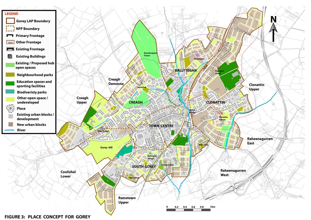
5 Neighbourhood Framework Plans Neighbourhood Framework Plans (NFPs) set out detailed urban design objectives and key components for key areas of the town. These are: The Town Centre Creagh Ballytegan Clonattin Gorey South. The Gorey Hill area is not included as an NFP as it is largely developed with remaining lands zoned for open space and amenity. The NFPs include components that may require later, more detailed urban design consideration or site/project briefs (larger site briefs may be prepared by the Council, while smaller site briefs are likely to be prepared by proposers of development in consultation with the Council). The graphics for each area highlight local urban design issues and provide indicative frameworks for local community spaces, routes, and landscape. In each of these frameworks, the overall planning and urban design intention is critical. The NFPs have been developed having regard to the principles of place-making that is the need to create distinctive places of character and high quality using, as a starting point, the positive aspects of local character and context. Local topography and landscape are important considerations in choosing the functional route and landscape structure of the NFPs. The NFPs prioritise connections between different developments and areas in Gorey. Local community spaces are located where they can serve as a focus for recreation, community facilities and local services in a built and landscape form that can provide a distinctive sense of place. The NFPs set out a robust structure that is based on appropriately-sized and shaped urban blocks within the route structure. These allow for a range of uses and building typologies (within a larger functional range) and provide for high levels of local permeability. The NFP shows urban blocks, which provide both efficiency, high levels of local permeability and connectivity to surrounding developments and future development areas. Indicative building frontage is also shown, with primary frontage indicating greater continuity and scale, being located along main routes and spaces and secondary frontage indicating lesser continuity and scale along other local streets and roads. As the NFPs are indicative frameworks, it is accepted that local or site constraints and opportunities may become apparent at later planning and design stages. This may require deviation from the indicative framework to achieve optimal planning outcomes. In all cases the main components of route and landscape structure and objectives must be realised and deviations from the framework must be justified on sound urban planning and design grounds and against the urban design objectives of this Local Area Plan. Where there are discrepancies between the proposals contained in the individual NFPs and the overall land use zoning objectives which are identified on Map 11, the land use zoning map will take precedence. 5
6 6
New-Cast Mixed-use Development Proposal King Street West, Newcastle, Ontario
 URBAN DESIGN BRIEF New-Cast Mixed-use Development Proposal King Street West, Newcastle, Ontario TABLE OF CONTENTS: 1.0 Executive Summary 2.0 Creating Vibrant and Sustainable Urban Places: Excerpts from
4.0 URBAN DESIGN FRAMEWORK. The vision for the future development of the plan area is to:
 4.0 The vision for the future development of the plan area is to: Create a new neighbourhood that focuses on the highly valued natural and aesthetic features of the lands and provides good quality homes,
Woodbrook - Shanganagh
 Section 4: Key Sites Framework Strategy Woodbrook - Shanganagh Local Area Plan 2017-2023 4. Site Framework Strategies The Master Plans shall have regard to the thematic objectives under the LAP Development
Memorial Business Park Site. Proposed Future Development. Design guidelines. August
 Memorial Business Park Site Proposed Future Development Design guidelines August 2014 www.designenvironment.co.nz 0064 3 358 3040 Contents 1.0 Background 1.1 Introduction 3 1.2 Objectives 4 2.0 Context
The Proposed Auckland Unitary Plan (notified 30 September 2013)
") 3 Business zones Introduction There are 10 business zones in the Unitary Plan: City Centre Metropolitan Centre Town Centre Local Centre Neighbourhood Centre Mixed Use General Business Business Park Light
3 Business zones Introduction There are 10 business zones in the Unitary Plan: City Centre Metropolitan Centre Town Centre Local Centre Neighbourhood Centre Mixed Use General Business Business Park Light
Chapter 5 Urban Design and Public Realm
 5.1 Introduction Public realm is all areas of the urban fabric to which the public have access. It is where physical interaction takes place between people. It therefore, includes buildings and their design,
QUEENSTOWN LAKES DISTRICT COUNCIL SUBDIVISION DESIGN GUIDELINES
 Attachment C: Draft QLDC Subdivision Design Guidelines QUEENSTOWN LAKES DISTRICT COUNCIL DESIGN GUIDELINES A DESIGN GUIDE FOR AND DEVELOPMENT IN THE URBAN ZONES QUEENSTOWN OFFICE 10 Gorge Road Queenstown
BLETCHLEY PARK AREA - DEVELOPMENT FRAMEWORK
 ANNEX A To Item 9 REVISED TEXT: additions shown bold and underlined, deletions in (brackets and in italics). BLETCHLEY PARK AREA - DEVELOPMENT FRAMEWORK This framework sets out the key objectives and requirements
Urban Design Manual PLANNING AROUND RAPID TRANSIT STATIONS (PARTS) Introduction. Station Study Areas
 Introduction. Station Study Areas") 111111 PLANNING AROUND RAPID TRANSIT STATIONS (PARTS) Introduction The ION rapid transit system will link Waterloo, Kitchener and Cambridge through a central transit corridor (CTC). There are a number
111111 PLANNING AROUND RAPID TRANSIT STATIONS (PARTS) Introduction The ION rapid transit system will link Waterloo, Kitchener and Cambridge through a central transit corridor (CTC). There are a number
CONTENTS 8.0 LAND USE 8.1 GENERAL LAND USE 8.2 RESIDENTIAL 8.3 MIXED USE 8.4 COMMERCIAL 8.5 EMPLOYMENT LANDS
 8-2 Land Use 8.0 LAND USE CONTENTS 8.1 GENERAL LAND USE 8.1.1 Uses provided for in all Land Use Designations 8.1.2 Uses prohibited in Hazardous Lands, Hazardous Sites and Special Policy Areas 8.1.3 Uses
East Bayshore Road Neighbourhood
 East Bayshore Road Neighbourhood Northridge Property Management Urban Design Brief 3195 East Bayshore Road City of Owen Sound January 2016 East Bayshore Road Neighbourhood Northridge Property Management
Nelson Residential Street Frontage Guideline
 DRAFT 22-06-2012 Nelson Residential Street Frontage Guideline June 2012 1317273 Contents and purpose Residential s are important Residential s are much more than corridors which move traffic. Streets allow
I615. Westgate Precinct
 I615. Westgate Precinct I615.1. Precinct Description The Westgate Precinct is located approximately 18km west of the Auckland city centre. There are seven Sub-precincts in the Westgate Precinct: Sub-precinct
URBAN DESIGN BRIEF. 2136&2148 Trafalgar Road. Town of Oakville
 URBAN DESIGN BRIEF 2136&2148 Trafalgar Road Town of Oakville Prepared By: METROPOLITAN CONSULTING INC For 2500674 Ontario Inc November 2016 TABLE OF CONTENTS Page No. 1.0 Introduction/Description of Subject
15 Urban Design Guidelines
 15 Urban Design Guidelines Aim: To create vibrant and bustling towns and villages with a diverse mix of activities where residents can benefit from quality urban living. 15.1 Background Through the planning
4 RESIDENTIAL ZONE. 4.1 Background
 4 RESIDENTIAL ZONE 4.1 Background The residential areas within the City are characterised by mainly lowrise dwellings sited on individual allotments. Past architectural styles, settlement patterns and
Keystone Business Park Precinct Structure Plan North East Industrial Precinct. Part 2 Design Principles
 Keystone Business Park Precinct Structure Plan North East Industrial Precinct Part 2 Design Principles Context Issues Services Landform Issues Geotech and contamination Ecology Traffic and access Issues
PUBLIC REALM STRATEGY
 CONSULTATION DRAFT PUBLIC REALM STRATEGY Trenchard Street & Frogmore Street City Design Group Place Directorate Public Realm Strategy Trenchard Street & Frogmore Street Contents 1. Introduction 2. Understanding
ELMVALE ACRES SHOPPING CENTRE MASTER PLAN
 ELMVALE ACRES SHOPPING CENTRE MASTER PLAN Contents 1.0 INTRODUCTION... 2 2.0 LOCATION... 2 3.0 EXISTING CONTEXT... 2 4.0 VISION & GUIDING PRINCIPLES... 2 5.0 LAND USE AND BUILT FORM... 4 5.1 St. Laurent
CONTENTS 6.1 URBAN DESIGN
 6-2 Urban Design and Sustainable Development 6.0 URBAN DESIGN AND SUSTAINABLE DEVELOPMENT CONTENTS 6.1 URBAN DESIGN 6.1.1 General Policies 6.1.2 The Public Realm 6.1.3 Streets and Blocks 6.1.4 Streetscapes
3.1 The hybrid planning application proposes the following description of development:
 CHAPTER 3: PROPOSED DEVELOPMENT 3.1 The hybrid planning application proposes the following description of development: Hybrid (part-outline/part-full) planning application for a single composite development
Housing Development at Balloonagh Tralee Co Kerry
 Design Statement Housing Development at Balloonagh Tralee Co Kerry Area of site 10,400m2 24 houses-12no 3 bed, 12no 2 bed and 4 single bed apartments total residential area of 2411m2 Open space provided
Chapter 2: OUTLINE PLANNING APPLICATION PROPOSALS. A New Garden Neighbourhood Matford Barton 17
 Chapter 2: OUTLINE PLANNING APPLICATION PROPOSALS A New Garden Neighbourhood Matford Barton 17 2.1. SUMMARY AND STATUS OF THE PROPOSALS 2.1.1. The parameter plans and associated wording in this chapter
8.0 Design and Form of Development 43/
 42/ 8.0 Design and Form of Development 43/ Rothwells Farm, Golborne/ Development Statement Figure 7. Site Constraints Key 44/ Site Boundary 360 Bus Route/Stops Existing Trees Underground Water Pipe Sensitive
Complete Neighbourhood Guidelines Review Tool
 Complete Neighbourhood Guidelines Review Tool Prepared By: City of Regina Planning Department October 2014 Page 1 of 14 Community Development Review Checklist for Secondary Plans and Concept Plans The
THREE PARKS ZONE Three Parks Special Zone The process of applying for resource consents in the zone.
 .25 Three Parks Special Zone The purpose of this zone is to provide for growth and to give effect to the Wanaka 2020 Community (2002) and the more recent Wanaka Structure (2007) and Wanaka Transport Strategy
WELLINGTON HOSPITAL DESIGN GUIDE TABLE OF CONTENTS
 WELLINGTON HOSPITAL DESIGN GUIDE TABLE OF CONTENTS 1.0 Introduction Page 2 The Place of Wellington Hospital 2 The Future of the Hospital 2 2.0 The Intention of the Design Guide 3 3.0 Analysis 4 General
URBAN DESIGN BRIEF URBAN DESIGN BRIEF 721 FRANKLIN BLVD, CAMBRIDGE August 2018
 URBAN DESIGN BRIEF URBAN DESIGN BRIEF 721 FRANKLIN BLVD, CAMBRIDGE August 2018 DESIGN BRIEF CONTENTS PART A 1.0 INTRODUCTION 2.0 DESCRIPTION & ANALYSIS OF SITE CONTEXT 3.0 DESIGN CONSTRAINTS AND OPPORTUNITIES
Chapter 13 Residential Areas: Appendices APPENDIX 1 Residential Areas
 Chapter 13 Residential Areas: Appendices Page 1 Chapter 13 Residential Areas: Appendices APPENDIX 1 Residential Areas Design Code for Intensive Housing INTRODUCTION DESIGN ELEMENTS A NEIGHBOURHOOD DESIGN
UNIVERSITY TOWN NEIGHBOURHOODS 5.5 HOUSING MELBOURNE CAMPUS MASTER PLAN 2014
 5.5 169 EXISTING CONDITIONS & VISION NEIGHBOURHOOD VISION The provision of on-campus housing into the future will continue to be an important element of the La Trobe University experience. A long-term
6 Site Framework Strategies
 6 Site Framework Strategies 6.1 Introduction Section 6 identifies a number of specific areas which are considered to be key sites within the Plan area and which may have potential for development / redevelopment.
medium desnity housing
 This section updated September 2013 This part of the Plan sets out the assessment criteria for medium density housing. The criteria are designed to give designers and builders flexibility and to provide
Section 4 - Public Realm & Landscape proposals Landscape Masterplan. Section 4 52
 - Public Realm & Landscape proposals Landscape Masterplan 52 Proposed Masterplan - Green Infrastructure Strategy District Park 4.33 Ha to provide Passive and active recreation with a large play area which
Regency Developments. Urban Design Brief. Holyrood DC2 Rezoning
 Regency Developments Urban Design Brief Holyrood DC2 Rezoning Stantec Consulting Ltd. 7-31-2017 1. Overview Regency Developments intends to rezone the lands located at 8510 and 8511 93 Avenue, within the
PUBLIC RIGHT-OF-WAY IN THIS CHAPTER PUBLIC REALM
 PUBLIC RIGHT-OF-WAY This section provides design guidelines for improvements in the public right-of-way. The public right-of-way refers to streets, sidewalks, non-vehicular thoroughfares, parks and greenways
AOTEA SUPERMARKET ZONE. Zone Introduction
 C18 AOTEA SUPERMARKET ZONE Zone Introduction C18.1 Objective This zone identifies a specific area in Aotea for a stand alone supermarket. The zone is site specific and has a range of objectives, policies
Town of Oakville Streetscape Strategy
 Town of Oakville Streetscape Strategy Endorsed by PDC on February 10, 2014 (PD-011-14) Town of Oakville Streetscape Strategy [endorsed by PDC February 10, 2014] 0 Town of Oakville Streetscape Strategy
CONTENTS 2.0 A FRAMEWORK FOR SUSTAINABLE GROWTH 2.1 MANAGING SUSTAINABLE GROWTH THE VISION TO GOALS AND OBJECTIVES 2.3 MARKHAM STRUCTURE
 2 A Framework for Sustainable Growth 2.0 A FRAMEWORK FOR SUSTAINABLE GROWTH CONTENTS 2.1 MANAGING SUSTAINABLE GROWTH THE VISION TO 2031 2.2 GOALS AND OBJECTIVES 2.2.1 Protecting the Natural Environment
Tāhuhu whakaruruhau ā-taone The sheltering ridge pole
 B2. Tāhuhu whakaruruhau ā-taone - Urban growth and form B2.1. Issues Tāhuhu whakaruruhau ā-taone The sheltering ridge pole Auckland s growing population increases demand for housing, employment, business,
Animating the Rideau Canal December 2013
 Executive Summary Animating the Rideau Canal December 2013 Why study the Rideau Canal? The Rideau Canal has been an important part of Ottawa throughout its history, and has shaped and been shaped by the
[PLANNING RATIONALE] For Site Plan Control and Lifting of Holding Zone By-Law 101 Champagne Avenue. May 23, 2014
![[PLANNING RATIONALE] For Site Plan Control and Lifting of Holding Zone By-Law 101 Champagne Avenue. May 23, 2014](/thumbs/75/71599615.jpg "[PLANNING RATIONALE] For Site Plan Control and Lifting of Holding Zone By-Law 101 Champagne Avenue. May 23, 2014") [PLANNING RATIONALE] For Site Plan Control and Lifting of Holding Zone By-Law 101 Champagne Avenue May 23, 2014 Contents 1.0 Introduction... 2 2.0 Site Context... 2 2.1 Adjacent Uses... 2 Figure 1: Site
[PLANNING RATIONALE] For Site Plan Control and Lifting of Holding Zone By-Law 101 Champagne Avenue May 23, 2014 Contents 1.0 Introduction... 2 2.0 Site Context... 2 2.1 Adjacent Uses... 2 Figure 1: Site
LOW DENSITY RESIDENTIAL
 LOW DENSITY RESIDENTIAL Corner lots with coach houses to increase diversity, provide unity to the streetscape and increase eyes on the street. Garages and ancillary units accessed via rear lanes. Parking
REMARKABLES PARK ZONE
 .10 Remarkables Park Zone.10.1 Resources, Activities and Values The Remarkables Park Area comprises approximately 150 hectares of perimeter urban land in the vicinity of Frankton and occupies a strategic
SQUAMISH 2010 AND BEYOND COMMUNITY VISION
 Our plan has been imagined and created to be both pragmatic and visionary. At the core of the strategy is a consideration of the highway s role and its impact on the community. First and foremost in creating
Highland Village Green Design Guidelines
 Highland Village Green Design Guidelines Publishing Information Title Highland Village Green Design Guidelins Author The City of Calgary Status DRAFT - Proposed document subject to changes Additional Copies
Subdivision Design Criteria. Penihana North GUIDELINES TO THE RULES
 Created September 2013 Penihana North Subdivision Design Criteria GUIDELINES TO THE RULES This part of the Plan sets out the design criteria for subdivision in Penihana North. The criteria will be considered
Next Steps / Development Process. Structure Plan. June submitted to City of Fremantle. Structure Plan. July supported for advertising
 overview What is today about? In July 0, the City of Fremantle resolved that the be advertised for public comment. Today is about: Understanding the history and context of the site Having your say on the
APPENDIX A: Kilternan Neighbourhood Framework Plan
 APPENDIX A: Kilternan Neighbourhood Framework Plan 95 www.dlrcoco.ie Kilternan Neighbourhood Framework Plan January 2010 dlr Architects Department dlr Planning Department Contents: Kilternan Neighbourhood
I539. Smales 2 Precinct
 I539. Smales 2 Precinct I539.1. Precinct Description The Smales 2 Precinct applies to a 4.8 hectare block of land located on the southern side of Northcote Road and fronting Lake Pupuke, Takapuna. The
PHASE III: Reserved Matters Submission
 Statement of Compliance with the outline approval for the proposed residential development of land at: BURGES LANE, WIVELISCOMBE PHASE III: Reserved Matters Submission Foreword Contents: This Statement
PART AOTEA PRECINCT
 CONTENTS... PAGE AOTEA PRECINCT...4 14.5.1 INTRODUCTION...4 14.5.2 RESOURCE MANAGEMENT ISSUES...4 14.5.3 RESOURCE MANAGEMENT OBJECTIVES AND POLICIES... 4 14.5.4 RESOURCE MANAGEMENT STRATEGY...5 14.5.5
Deicke Richards Aug 2009 Rev A. Varsity Station Village A master plan for a TOD
 Deicke Richards Aug 2009 Rev A Varsity Station Village A master plan for a TOD Introduction The Varsity Station Village project is transforming empty governmentowned industrial land on Queensland s Gold
SCHEDULE 12 TO THE DESIGN AND DEVELOPMENT OVERLAY GLEN WAVERLEY ACTIVITY CENTRE STRUCTURE PLAN
 DD/MM/YY Proposed C120 SCHEDULE 12 TO THE DESIGN AND DEVELOPMENT OVERLAY Shown on the planning scheme map as DDO12. GLEN WAVERLEY ACTIVITY CENTRE STRUCTURE PLAN 1.0 Design objectives DD/MM/YY Proposed
2.0 A FRAMEWORK FOR SUSTAINABLE GROWTH CONTENTS
 2-2 A Framework for Sustainable Growth 2.0 A FRAMEWORK FOR SUSTAINABLE GROWTH CONTENTS 2.1 MANAGING SUSTAINABLE GROWTH THE VISION TO 2031 2.2 GOALS AND OBJECTIVES 2.2.1 Protecting the Natural Environment
01 the vision NEW LYNN IS WAITING FOR THE GREAT LEAP FORWARD
 [A] FRAMEWORK 01 the vision 02 the framework 03 urban design principles 04 c o n t e x t 05 issues a n d o p p o r t u n i t i e s 06 creating a t.o.d. 07 key recommendations 08 seven strategic areas of
2A District-wide Policies
 2A Introduction This Chapter contains policies which are relevant to subdivision, use and development activities occurring across all zones and areas of the District. The policies in this Chapter implement
Community Design Guidelines. Port Wallace DRAFT
 Community Design Guidelines Port Wallace DRAFT Energy 1 2 3 Nature Movement Connections Built Form DRAFT Layout Energy 1 Nature Community Design Guidelines GREAT COMMUNITIES PROTECT, CELEBRATE, AND CONSERVE
GUIDING PRINCIPLES IN THIS CHAPTER
 GUIDING PRINCIPLES The guiding principles and design concepts in this chapter work together with the Chapel Hill 2020 Comprehensive Plan to support new public places that can be enjoyed by all while also
SECTION TWO: Overall Design Guidelines
 SECTION TWO: Overall Design Guidelines This section provides overall design principles and guidelines for the Gardnerville Mixed-use Overlay. They provide criteria for mixed-use places consisting of residential,
2.0 Strategic Context 4
 2.0 Strategic Context 4 2.1 The Area Action Plan is a non-statutory plan, which forms a corporate policy document, expressing particular issues and areas of concern while also providing a vision for the
Subdivision and Development
 Subdivision and Development 8.0 Introduction - Subdivision and Development The principle purpose of subdivision is to provide a framework for land ownership so that development and activities can take
5.1 Site Plan Guidelines
 5. Community Core Guidelines Development of the Community Core will take place by plan of subdivision and site plan approval. It will occur in a phased manner that will reflect the timing of residential
City of Vaughan Urban Design Guidelines for Infill Development in Established Low-Rise Residential Neighbourhoods
 City of Vaughan Urban Design Guidelines for Infill Development in Established Low-Rise Residential Neighbourhoods DRAFT - September 2016 Contents 1. Introduction 1 2. Policy Context 3 3. Characteristics
Carton Avenue Action Area Plan Maynooth
 Carton Avenue Action Area Plan Maynooth Kildare County Council JULY 2006 (AAP) Table of Contents Section 1. Introduction...3 Statement of Strategy...3 Location of the Lands...3 Context in the Town Development
elbridge Core Strategy
 C elbridge Core Strategy Celbridge is designated as a Moderate Growth Town in the RPGs. The County Development Plan reinforces this designation in its settlement strategy. Moderate Growth Towns within
YONGE STEELES CORRIDOR SECONDARY PLAN. Young + Wright / IBI Group Architects Dillon Consulting Ltd. GHK International (Canada) Ltd.
 Ltd.") PART A: PREAMBLE 1.0 PURPOSE The purpose of this Secondary Plan is to provide a development framework for intensification of the Yonge/ Steeles corridor including the north side of Steeles Avenue West
PART A: PREAMBLE 1.0 PURPOSE The purpose of this Secondary Plan is to provide a development framework for intensification of the Yonge/ Steeles corridor including the north side of Steeles Avenue West
Draft Urban Hamilton Official Plan. Amendment No. XX
 1 of 75 The following text, together with: Draft Appendix A Appendix B Volume 1, Schedule E-1 Urban Land Use Designations Appendix C Volume 1, Appendix A Parks Classification Map Appendix D Volume 1, Appendix
Clair-Maltby Community visioning
 Clair-Maltby Community visioning workshop #1 Summary April 27th, 2017 Table of Contents INTRODUCTIon 1 PURPOSE 1 CONSULTATION STRUCTURE 2 PARTICIPANT FEEDBACK 3 VISIONING EXERCISE 8 ONLINE SURVEY RESULTS
Urban Design Brief Proposed Residential Development 5219 Upper Middle Road City of Burlington
 Urban Design Brief Proposed Residential Development 5219 Upper Middle Road City of Burlington Prepared by Weston Consulting Prepared for BLOOMFIELD DEVELOPMENT INC. Date: March 2017 Table of Contents 1.
Policies and Code Intent Sections Related to Town Center
 Policies and Code Intent Sections Related to Town Center The Town Center Vision is scattered throughout the Comprehensive Plan, development code and the 1994 Town Center Plan. What follows are sections
Design Guidance. Introduction, Approach and Design Principles. Mauritius. November Ministry of Housing and Lands. .. a
 sig evelo r D Mauritius s. Utilities.. Individu a s. er itects.to ls chpers.po e Public. T. h rban D Sc U e me Promot e h ners. A Design Guidance o.h Planne rs n w iticians r l useholde National Development
THE CITY OF VAUGHAN BY-LAW BY-LAW NUMBER A By-law to adopt Amendment Number 1 to the Official Plan of the Vaughan Planning Area.
 THE CITY OF VAUGHAN BY-LAW BY-LAW NUMBER 015-2014 A By-law to adopt Amendment Number 1 to the Official Plan of the Vaughan Planning Area. NOW THEREFORE the Council of the Corporation of the City of Vaughan
Plan Modification to Chapter B2 of the Auckland Unitary Plan(AUP) Operative in part (15 November 2016)
 Operative in part (15 November 2016)") UNITARY PLAN UPDATE REQUEST MEMORANDUM TO FROM Phill Reid Linley Wilkinson DATE 25 September 2018 SUBJECT Plan Modification to Chapter B2 of the Auckland Unitary Plan(AUP) Operative in part (15 November
UNITARY PLAN UPDATE REQUEST MEMORANDUM TO FROM Phill Reid Linley Wilkinson DATE 25 September 2018 SUBJECT Plan Modification to Chapter B2 of the Auckland Unitary Plan(AUP) Operative in part (15 November
B. Blocks, Buildings and Street Networks
 B. Blocks, Buildings and Street Networks Figure IV.4 A rational block pattern with connected streets Introduction The single most important element in the physical and functional integration of mixed use
Derry Green Corporate Business Park
 Town of Milton Derry Green Corporate Business Park Urban Design Guidelines BMI/Pace - June 2010 Draft 3 Prepared by: Brook McIlroy Planning + Urban Design / Pace Architects Suite 300-51 Camden Street Toronto,
Welcome to Our Open House
 Welcome to Our Councillor Gerbasi & the Planning, Property, & Development Department welcome you to tonight s open house The open house outlines the proposed Osborne Village Neighbourhood Plan a secondary
I609. Penihana North Precinct
 I609. Penihana North Precinct I609.1. Precinct description The Penihana North Precinct is located south of the Swanson Railway Station, adjacent to the Rural Urban Boundary (RUB) and Waitakere Ranges Heritage
Ensure that development within the Arrowtown Urban Growth Boundary provides:
 URBAN DEVELOPMENT 4 4.2.5.2 Ensure that development within the Arrowtown Urban Growth Boundary provides: an urban form that is sympathetic to the character of Arrowtown, including its scale, density, layout
Land Use Amendment in Southwood (Ward 11) at and Elbow Drive SW, LOC
 at and Elbow Drive SW, LOC") 2018 November 15 Page 1 of 10 EXECUTIVE SUMMARY This land use amendment application was submitted by Rick Balbi Architect on 2017 August 31 on behalf of Sable Developments Ltd, and with authorization from
2018 November 15 Page 1 of 10 EXECUTIVE SUMMARY This land use amendment application was submitted by Rick Balbi Architect on 2017 August 31 on behalf of Sable Developments Ltd, and with authorization from
*** DRAFT 2 FOR PUBLIC REVIEW ***
 6.7 The area is generally bounded by the Red Hill Valley Parkway to the west, Lake Avenue to the east, the Queen Elizabeth Way (QEW) to the north, and by the properties just south of Queenston Road to
DAVENPORT VILLAGE SECONDARY PLAN
 27 DAVENPORT VILLAGE SECONDARY PLAN 27. DAVENPORT VILLAGE SECONDARY PLAN 1. VISION FOR THE DAVENPORT VILLAGE SECONDARY PLAN Davenport Village, municipally known as 830, 940, 980 and 1100 Lansdowne Avenue,
East Grove Public Realm
 H - - MP - Elephant Park Public Realm RO EY DN NEW KENT ROAD E AC PL The public realm has been designed to create an environment which is easy to move through, accessible to all, safe and playful. The
Urban Design Site Assessment
 1150 Great North Road/8 Parr Road North, Point Chevalier Urban Design Site Assessment (8th February 2017) 1. Introduction and Overview 0B It is proposed to develop land at 1150/1158 Great North Road and
RESIDENTIAL. QLDC PROPOSED DISTRICT PLAN [PART THREE] DECISIONS VERSION 8 medium density residential
![RESIDENTIAL. QLDC PROPOSED DISTRICT PLAN [PART THREE] DECISIONS VERSION 8 medium density residential](/thumbs/84/89275880.jpg "RESIDENTIAL. QLDC PROPOSED DISTRICT PLAN [PART THREE] DECISIONS VERSION 8 medium density residential") 8 MEDIUM DENSITY RESIDENTIAL QLDC PROPOSED DISTRICT PLAN [PART THREE] DECISIONS VERSION 8 medium density residential QLDC PROPOSED DISTRICT PLAN [PART THREE] DECISIONS VERSION 8 medium density residential
8 MEDIUM DENSITY RESIDENTIAL QLDC PROPOSED DISTRICT PLAN [PART THREE] DECISIONS VERSION 8 medium density residential QLDC PROPOSED DISTRICT PLAN [PART THREE] DECISIONS VERSION 8 medium density residential
INSTITUTIONAL USE DESIGN COMPATIBILITY TECHNIQUES
 INSTITUTIONAL USE DESIGN COMPATIBILITY TECHNIQUES INTRODUCTION Community institutions are an important part of the character and vitality of neighborhoods in Forsyth County. Institutional uses include
DRAFT. October Wheaton. Design Guidelines
 October 2011 DRAFT Wheaton Design Guidelines 2 Draft - Design Guidelines - Wheaton Sector Plan Contents 04 Section 1: Introduction 06 Section 2: Context 08 Section 3: Design Guidelines 09 Goal 1: Create
39 WALLACEVILLE STRUCTURE PLAN
 39 WALLACEVILLE STRUCTURE PLAN PRECINCT DESCRIPTIONS, INTENTIONS AND OUTCOMES Wallaceville Living Precinct Area A At approximately 13.4ha, this precinct is the largest precinct and the precinct provides
DRAFT DRAFT DRAFT DRAFT
 # 19 EXPAND GREEN AND OPEN SPACES AND COMMUNITY FACILITIES IN TANDEM WITH NEW DEVELOPMENT The role of Eglinton will change in the coming years, along with the intensity of activity and land uses. As more
PORT WHITBY COMMUNITY
 PORT WHITBY COMMUNITY SECONDARY PLAN UPDATE COMMUNITY IMPROVEMENT PLAN URBAN DESIGN GUIDELINES September 2015 DRAFT PROPOSED AMENDMENT NUMBER # to the Whitby Official Plan PURPOSE: The intent of this Amendment
LUNDY S LANE COMMUNITY IMPROVEMENT PLAN STUDY
 PUBLIC INFORMATION MEETING #2 October 12, 2016 LUNDY S LANE COMMUNITY IMPROVEMENT PLAN STUDY AGENDA 5:00 to 5:30pm: Open House 5:30 to 6:15pm: Presentation 6:15 to 7:00pm: Individual paced workshop with
BROADWAY-ARBUTUS POLICIES. Adopted by City Council on July 7, NOTE: To be considered in combination with applicable guidelines
 50 City of Vancouver Land Use and Development Policies and Guidelines Community Services, 453 W. 12th Ave Vancouver, BC V5Y 1V4 F 873.7344 fax 873.7060 planning@city.vancouver.bc.ca BROADWAY-ARBUTUS POLICIES
15. Urban Design AIM. 340 Kildare County Development Plan Kildare County Development Plan
 . Urban Design AIM To create vibrant and bustling towns and villages with a diverse mix of activities where residents can benefit from quality urban living. 340 Kildare County Development Plan 2017-2023
appendix and street interface guidelines
 appendix five: building and street interface guidelines appendix 5 building and street interface guidelines BOULEVARDS Boulevards are generally characterized by higher levels of traffic movement at higher
Yonge Eglinton Centre Urban Design Guidelines
 Yonge Eglinton Centre Urban Design Guidelines City Planning Urban Design January 2009 YONGE EGLINTON CENTRE INTRODUCTION.................................................... 1 GENERAL SITE PLAN OBJECTIVES......................................
Urban Design Brief to 1557 Gordon Street & 34 Lowes Road West
 Urban Design Brief 1533 to 1557 Gordon Street & 34 Lowes Road West Reid s Heritage Homes Ltd. & 883928 Ontario Ltd. and RHH Property Management Ltd. City of Guelph Zoning By-law Amendment November 2017
URBAN DESIGN BRIEF NORTHVIEW FUNERAL HOME HIGHBURY AVE N, LONDON, ON
 URBAN DESIGN BRIEF NORTHVIEW FUNERAL HOME - 1490 HIGHBURY AVE N, LONDON, ON 1.1Purpose The intent of the following report is to identify an opportunity for redevelopment of two residential properties within
Appendix D: Rockbank Major Town Centre key design principles
 Appendix D: Rockbank Major Town Centre key design principles ATTRACTING INVESTMENT & SUPPORTING THE COMMUNITY Principle 1 Create a focal point for a diverse range of uses within the town centre that are
DELEGATED DECISION on 1st September 2015
 Application N o : 14/04810/OUT LONDON BOROUGH OF BROMLEY TOWN PLANNING RENEWAL AND RECREATION DEPARTMENT DELEGATED DECISION on 1st September 2015 14/04810/OUT Claire Harris 4 Oaklands Road Bromley BR1
This Review Is Divided Into Two Phases:
 Semiahmoo Town Centre Review The purpose of this review: To review the Semiahmoo Town Centre Concept Plan, originally approved in 1993, to ensure that this centre will continue to serve the needs of South
Urban Design Guidelines Townhouse and Apartment Built Form
 Urban Design Guidelines Townhouse and Apartment Built Form Town of Wasaga Beach Table of Contents 1. Introduction 1.1. Purpose 1.2. Urban Design Principles 1.3. Application of Guidelines 2. Site Design,