01.02 Impervious Soil Coverage (Sealing of Soil Surface) (Edition 2012)
|
|
|
- Alyson Berniece Harrell
- 5 years ago
- Views:
Transcription
1 Senate Department for Urban Development and the Environment Impervious Soil Coverage (Sealing of Soil Surface) (Edition 2012) Overview Data on impervious soil coverage are regularly used in the offices of the Berlin administration responsible for environmental protection and for urban and landscape planning. One main area of application is the use and processing in various models, such as urban climate and water balance, or in various evaluation methods, such as soil protection. But the documentation of the condition of the impairment of nature and the landscape due to impervious soil coverage is also of great significance. Finally, policy-makers increasingly require data on impervious coverage in high time-resolution, in order to monitor and measure the success of environmental or urban-planning strategies. Definition The impervious coverage of natural soils has a number of negative effects on the ecosystem and on the human habitat. Impervious coverage means the paving of the soil with non-porous materials. The categories of impervious areas are: built-up impervious areas, i.e., buildings of all kinds; and nonbuilt-up impervious areas, i.e., roads, parking lots, paved walkways, etc. In addition to building complexes and surfaces completely imperviously paved with asphalt or concrete, more porous paving types are also considered impervious, although these often have very different ecological qualities. Such coverings as honeycomb brick or paving stones with wide seams still permit reduced plant growth, are partially permeable to water, and provide for a considerably more favourable microclimate. The existing types of pavement were grouped into four pavement classes, with different effects on the ecosystem (cf. Table 1). Tab. 1: Overview of Pavement Classes Pavement Class Estimated effects on ecosystem Types of pavement 1 extreme Asphalt, concrete, paving stones with joint sealer or concrete substructure, synthetic surface materials 2 high Artificial stone and plates (edge length > 8 cm), concrete-stone composites, clinker, medium and large-sized paving stones 3 medium Small-stone and mosaic paving (edge length < 8 cm) 4 low Grass trellis stones, water-bound pavement (i.e. ash, gravel or tamped ground), gravel lawn Tab. 1: Overview of impervious pavement classes The Effects of Impervious Coverage on the Natural Balance The effects of impervious coverage are felt primarily in cities and metropolitan areas, where a high proportion of the total area is impervious. Among the various effects on the ecosystem is first of all the fact the impervious coverage contributes to the development of a specific urban climate. The air is heated by the high heat-storage capacity of buildings and asphalt streets. Especially in summertime, night-time cooling is reduced (cf. Fig. 1). 1
2 Fig. 1: Temperature Curves Over Various Surfaces (Kessler 1971 in: Mählenhoff 1989) At the same time, the relative atmospheric humidity too is reduced, since vegetation-covered areas and the evaporation they generate is lacking. This can lead to the occurrence of extreme values which can impair human well-being considerably. In this context, pervious areas, such as parks, play a major role. Parks of even one hectare in size or more have a demonstrably positive climatic effects on human well-being. Vegetation-covered areas also have an effect on the dust and pollutant contents of the air, since, with their large leaf surfaces, they are able to bind dust particles and other air pollutants. The effects of impervious coverage on the Berlin urban climate are described in detail in various maps of the chapter 04 Climate. Impervious coverage of the soil also causes profound changes in the water balance, due to the loss of evaporation and seepage surfaces for precipitation. The rainwater runoff from impervious areas, heavily polluted by tire abrasion, dust, dog excrement, etc., is passed by via the sewage system either directly into the tributaries or into sewage-treatment plants (cf. Map 02.09, Management of Rain and Waste Water). Impervious coverage and condensation moreover strongly disturb the functions of the soil. The blockage of the water and oxygen supply destroys most soil organisms. Since no more water can seep down, the pollutants introduced via the air and precipitation are no longer retained in the soil, and are washed into the surface waters. The complete impervious coverage of the soil causes the complete loss of all flora and fauna, but even partial impervious coverage always means habitat loss. Biotopes are fragmented or isolated, while sensitive species are crowded out in favour of more adaptable species. In addition to the above-described consequences for the ecosystem, the degree of impervious coverage in urban areas also has an immediate effect on the human habitat. A high degree of impervious coverage is usually associated with a disparity of open space per capita. Long rows of buildings, frequently interrupted only by asphalt or concrete surfaces, can have a depressing, monotonous effect on residents. Such factors of nature as the change of the seasons can no longer be experienced in the immediate residential environment. Increased dependence on nearby recreation areas at the outskirts of a city on the other hand generates traffic, which also has a negative effect on the environment. Impervious Coverage and Land Consumption in Germany In Germany, impervious areas accounted for approx. 6 % of the total area in This corresponds to an impervious area of 2.16 million ha (State statistical offices, 2011). 2
3 In the political debate, the environmental indicator land consumption is primarily cited, and has also found its way into the national sustainability strategy. There, since 2002, the goal of reducing land consumption to 30 ha per day by 2020 has been formulated. Daily land-consumption demand in Germany for residential/commercial and traffic use was 78 ha in 2009 (UBA 2011). Nationwide, the increase in areas used for buildings and open spaces is clearly on the decline. The increase in land areas used for traffic purposes, while it is lower than the increase in areas used for residential/commercial purposes, is still approx. 23 ha/day, and has thus not changed over the course of the past 20 years. Land consumption has been reduced in recent years, due to the economic situation, the drop in new road building, and the impervious coverage regulations for new buildings; however, it is still a long way from the target for Land consumption is calculated from the daily increase in built-up and traffic areas. This is not equal to the impervious area, since it also includes areas which are only slightly impervious, such as gardens in residential areas or green median strips on roads, etc. The Federal-State Cooperative Association for Soil Protection (LABO) in 2005 appointed a group of federal and state experts to develop a suitable assessment procedure for ascertaining soil impervious coverage at the state level, in order to expand the sustainability indicator land consumption for residential/commercial and traffic areas to include the component impervious coverage. The results of the experts group are incorporated into the System of Integrated Environmental and Economic Accounting (SEEA) by the Working Group on Environmental-Economic Accounting of the German States (EEAL), and have been documented in the report Indikator Versiegelung, (the indicator Impervious Coverage / Frie & Hensel 2007). See too the Excursus Versiegelungsdaten [impervious coverage data] 2011 and 2005, below, which compares the present results with those of the Indikator Versiegelung, by the EEAL. The reduction of land consumption, which is a goal of the Sustainability Strategy, is to be achieved by space-reduced construction of buildings, densification of urban areas, concentration of infrastructure, provision of compensation areas, and the removal of impervious surfaces no longer used (space recycling). With the increase of the quality of the living environment in residential areas, concentrated housing in the city is to be reestablished as an alternative to the home in the green suburbs once again. (Bundesregierung 2007). Germany s states and municipalities are to realize these targets in the context of their spatial and construction planning. Legally mandatory stipulations are also being used to reduce impervious coverage. The impervious-coverage removal requirement under 5 of the Federal Soil Protection Law (BBodSchG) of 1998 is designed to provide compensation for land consumption, by causing areas no longer used to be made pervious again, and thus regain their natural soil functions, as per 2 Sect. 2 BBodSchG. The law makes allowance for reasonable expense and burden (Oerder 1999,.pp. 90 ff.). However, since costs and reasonableness of the imposition are taking into account, this regulation has not proven itself in practice. A further possible instrument for reducing impervious coverage is financial incentives at the individual level. For example, Berlin has since January 1, 2000, invoiced the charge for precipitatewater sewage separately. The introduction of this so-called fee-splitting is based on a ruling by the Federal Administrative Court (ruling of June 12, 1972) and the Superior Administrative Court of Lüneburg (rulings of June 14, 1968 and of April 10, 1980). These rulings stated that in municipalities in which the cost of precipitate-water sewage disposal accounts for more than 15% of the total costs of sewage disposal, the fees must be invoiced separately, so that the fee for precipitate-water sewage disposal is no longer linked proportionally to the general sewage fee, but is rather charged according to the impervious share of the property from which waste water is fed into the sewage system (BWB 1998). Therefore, owners have since 2000 endeavoured to keep the impervious area of their property as low as possible, in order to save on sewage fees. Since the new Precipitate-Water Exemption Ordinance of August 2001 came into effect (the Ordinance on Exemption from Requirement for Permission for Harmless Percolation of Precipitate Water NWFreiV, August 24, 2001), it is possible to obtain proportionate or full exemption from the precipitate-water sewage disposal fee (SenStadt 2001) via measures for relieving the rainwater sewage system via-water percolation on one's own property, without permission. Statistical Base Data on impervious soil coverage for Berlin have been available in the Environmental Atlas since the beginning of the 80s. At first, this was true only for the western part of the city; since the political change in the East, a full-coverage data stock has been built up and maintained over the course of a 3
4 number of shifts of emphasis and updates. However, this data base was no longer up-to-date, and was moreover based on non-uniform surveying methods. In cooperation with the Berlin University of Technology, the Humboldt University and the company Digitale Dienste Berlin, a new procedure for ascertaining impervious coverage was developed for the 2007 Edition. It is now been partially re-adapted and used for the 2012 Edition. The databases for impervious coverage which had existed previously had been based on non-uniform ascertainment methods, for which reason a direct comparison was not possible. The present reuse of this ascertainment method now permits an overall comparison of degrees of impervious coverage between 2005 in The following specialized information and geo-data, as well as satellite-image data, have been used: The Urban and Environmental Information System, Block Map 1: 5,000 (ISU 5) and Land Use Data The spatial reference of the City and Environment Information System (ISU) is oriented toward the structure of the statistical blocks of the Regional Reference System (RBS) of the Berlin-Brandenburg Bureau of Statistics. However, each block may be further subdivided into homogeneous-use block segments. For each of the approx. 25,000 sections of the ISU 5 structure, a 16-digit key is stored in a database, in which information on both section size and use is stored. A total of 52 section types with homogeneous use and spatial structures are distinguished. The ISU 5 was used for the impervious coverage maps current as of Dec. 31, The ISU data were used as follows in the evaluation process: The geometric data served to delimit blocks and distinguish streets and bodies of water. Sections outside the statistical blocks were not analyzed. The degrees of impervious coverage were calculated at the ISU block and block segment levels. The ISU utilization data were used for the stratification of the municipal area, and were fed into the rule-based classification system. In the course of the updating of the database in 2010, not only were the block geometries further developed, but the categories and the information on land use and urban structure were also revised. In this process, changes in the mapping methodology, e.g., the definition of section types, were undertaken, which had implications for the impervious coverage mapping methodology developed for the Database For the impervious coverage investigation in 2011, it was therefore necessary to undertake certain procedural modifications. Automated Map of Properties (ALK) In Berlin, the lot-referenced factual and geometric data of the Register of Land Properties is maintained in the form of the Automated Book of Properties (ALB) and Automated Map of Properties (ALK). The data stock of the Berlin ALK covers the entire area of the State of Berlin and consists of approx. 1.5 million properties, largely fields and buildings. The vector data of the ALK, current as of December 2010, were used for the delimitation of buildings within the ISU blocks, and for the specification of remaining areas as non-built-up block space, and hence as analysis areas for satellite-image evaluation. With regard to the integration of the ALK data into the evaluation process, it was ascertained that facilities on railyards and urban-rail stations, and also buildings in industrial and commercial areas, were frequently missed. Due to a change in the definition of buildings, summer cottages in allotmentgarden areas are no longer included in the current ALK. Map of Berlin 1:5,000 - K5 The map of Berlin by the State Mapping Agency at a scale of 1:5,000 (K5) is drafted by the Berlin boroughs on the basis the Berlin ALK. The above-ground railway lines shown in the K5 Map were used for the impervious-coverage maps current as of January 2006, to the extent that these were provided by the boroughs. The lot-precise recording of track beds was used primarily for the mapping of the shaded railway lines in forests, such as that north of Müggel Lake. 4
5 Orthophotos The full-coverage digital orthophotos used were taken from real-colour aerial-photography material shot in July and August In the K5 sheet-line system, they are available in a resolution of 0.25 m, and were used for the following work steps: Ascertainment and delimitation of reference sections, Ascertainment and delimitation of sections to be corrected (e.g. water bodies not recorded). Data on Impervious Soil Coverage of the Berlin Water Utility In the process of the evaluation, so-called corrective factors for ascertaining the degree of impervious coverage were used for certain section types. The purpose was to correct the view from the air, in which the impervious coverage is often largely obscured by trees, with certified information on impervious coverage. The corrective factors developed and tested in 2007 were used again. The ascertainment of corrective factors was carried out on the basis of the current impervious coverage information of the Berlin Water Utility (BWB). Starting in January 2000, these data were collected in connection with the changed calculation of the precipitate-water fees. The BWB aerial photography and the ALK served for the initial recording of the impervious sections of the properties. Moreover, the checked information of the property owners was incorporated (WTE 2004). The lot-precise data was aggregated at the ISU block-segment level, and was available for evaluation, current as of Only the details on the non-built-up impervious sections were used. Lot-precise local observation and recording permitted a very high degree of precision of data on impervious soil coverage to be obtained. Multi-Spectral SPOT5 Scene In 2011, the state of Berlin issued a contract for the photography of a SPOT5 scene. For the development of the procedure and the preparation of the impervious-coverage map, it was ultimately possible to use a multi-spectral SPOT5 scene of May 8, 2011 as a system-corrected data set. The photo was free of clouds. The analysis of the spectral bands showed only very low atmospheric impairment. The pan angle was approx. 1.9, and tilts of buildings were negligibly low, so that in the context of this project, an ideal scene was available. Due to the seasonal lighting conditions, the shaded areas were relatively large; however, they were in any case treated separately in the development of the procedure. Methodology The evaluation procedure was based on the use of ALK data for impervious built-up sections, and on the analysis of high-resolution multi-spectral satellite-image data for the impervious non-built-up sections. Once again, a SPOT5 scene was used. Relevant information from the Environmental Atlas, the Urban and Environmental Information System (ISU), and the already ascertained corrective factors developed from the data of the Berlin Water Works (BWB data) were incorporated into the classification process. The ISU statistical blocks serve as reference surfaces. You to the new satellite-image seen and the changes in the ISU section types in 2010, the mapping procedure had to be slightly adapted, and now consists of three evaluation steps: Mapping of impervious built-up sections Mapping of impervious non-built-up sections Derivation of the degree of impervious coverage. The mapping of impervious coverage concentrates on the areas of the statistical blocks; transportation routes and bodies of water are not considered. The following illustration shows the use of the various data from the agencies and from geo- and satellite image data in the Berlin mapping procedure for impervious sections. The complete Final Report of the Impervious Coverage Mapping Procedure 2011 can be downloaded from the chapter Literature as a PDF file (in German). 5

6 Fig. 2: Diagram of the Hybrid Mapping Procedure Mapping of Built-up Impervious Sections The delimitation of the built-up impervious sections was carried out exclusively on the basis of ALK data. Their integration into the mapping process constituted the first component of the hybrid method approach. For these sections, no evaluation has been carried out via satellite-image data. With regard to the mapping precision of the built-up impervious sections, the familiar problems with regard to the topicality of ALK data must be considered. Particularly buildings on industrial and commercial areas, as well as urban rail stations, are frequently missed, partially or entirely. Due to a change in the definition of buildings, summer cottages in allotment garden areas are no longer included in the current ALK. The share of built-up impervious space in allotment garden areas therefore had to be calculated separately. Mapping of Impervious Non-built-up Sections For the mapping of the impervious non-built-up sections, a classification approach was used in which satellite-image data (SPOT5) and geo-data (ALK, ISU) were incorporated and combined. This procedure took into account the following criteria: Mapping of the entire municipal area Low expenditure of time and effort for the pre-processing of the satellite-image data o o use of geo-coded, system corrected data coverage of the municipal area with as few scenes as possible Low expenditure of time for the analysis of the satellite-image and geo-data Restriction of use of terrestrial photos, or controls to ensure they be kept to a minimum Flexible sensor and scene selection Realization of a high degree of automation Integration of the mapping results into the ISU. The satellite-image evaluation consists of the following evaluation focuses. Categorization of Section Types Relevant for Remote Sensing To improve the mapping results, a categorization of ISU section types according to the remotesensing-relevant criteria building height, vegetation height, reflection quality, heterogeneity and relief, as well as the average degrees of impervious coverage (2001) was carried out. This permitted 6

7 spatially separate segment classification, and optimized choice of methodology. Eighteen categories were defined (Table 2), which had to be adapted to the new ISU section types of adopted in Some adaptations have also affected the ascertainment of changes between 2005 and 2011, and required special consideration. In the course of the updating of ISU section types in 2010, uses were not only updated, but also corrected. In the course of the automated evaluation process, unchanged block sections were thus assigned to different impervious coverage categories (pseudo-changes). This involved 718 block sections. Major changes in ISU block geometry affected 244 block sections between 2005 and 2010, i.e., the section sizes had changed by more than 10 %. Here too, pseudochanges in impervious coverage mapping could result. Spectral Classification of Non-Built-Up Areas The satellite-based remote-sensing data were further processed by means of a machine-based, automatic classification procedure. First, the degree of vegetation coverage of non-built-up areas was ascertained via the Normalized Differenced Vegetation Index (NDVI). This index is based on the fact that healthy vegetation reflects relatively little radiation in the visible spectral range (wavelengths of approx. 400 to 700 nm), and relatively much more in the subsequent near-infrared range (wavelengths of approx. 700 to 1300 nm). In the near-infrared range, this reflection is strongly correlated with the vitality of a plant: the greater the vitality, the higher the increase of the reflection coefficient in this spectral range. Other surface materials, such as soil, rock or even dead vegetation, show no such distinctive difference in reflection coefficients for these two ranges. This fact can thus serve on the one hand to distinguish areas covered with vegetation from bare areas, and also to obtain information on photosynthetic activity, vitality and density of vegetation cover. This standardization yields a range of values between -1 and +1, where an area containing a dense vegetation canopy will tend to positive values (say 0.3 to 0.8) (Wikipedia 2007). Particularly relevant surface materials, such as sand, ash and tamped soil, railway-track gravel, artificial surfacing, as well as shaded areas, which are frequently evaluated faultily, must continue to be examined with special care. Fig. 3 shows the spectral classification procedure, which consists of 6 partial evaluations. Fig. 3: Diagram of the Spectral Classification of Non-Built-Up Sections The degrees of impervious coverage are obtained step-by-step from the degrees of vegetation coverage per pixel ascertained. The method is based on the following assumptions: 7
8 There is a linear connection between NDVI and degree of vegetation coverage: the higher the NDVI value, the more vital vegetation will be present. There is a high negative correlation between degree of vegetation coverage and degree of impervious coverage. Vegetation-free spaces (degree of vegetation: 0 %) are reflected by low to very low index values. More detailed distinctions between impervious and pervious sections are not possible via NDVI. Areas completely covered by green vegetation, such as forests or grasslands (degree of vegetation: 100 %) are largely reflected by high to very high index values. These areas were classified as pervious. The problem of the local obscuring by treetops of impervious areas is not soluble via the evaluation of satellite-image data. To correct for this error, context-related correction factors were ascertained and used, with the aid of ISU data. The ascertainment and distinction process of the graduation of degrees of vegetation coverage (degree of vegetation coverage: >0 % and <100 %) was methodologically demanding. Medium index values predominated. The fact that identical index values could result from different mixtures of signatures had to be taken into account. The present procedural development made use of these differences: NDVI values which indicate partial vegetation coverage of sections (vegetation degree >0 %) were considered in a differentiated manner, and assigned to different degrees of impervious coverage in the rule-based classification system, depending on section type or section-type category. Based on this approach, 12 NDVI categories were established (cf. Table 2). In the context of the process of the mapping of changes, the degrees of impervious coverage in 2005 are to be compared with those in 2011, for which purpose the spectral properties and phenological properties of a satellite image scene taken in May and of one taken in September are to be considered and rendered comparable. To that end, the satellite images of 2011 were adapted both geometrically and radiometrically to the existing reference system of 2005, the so-called master scene. Track gravel was to be evaluated differently in the context of the use of the data on impervious coverage. In some contexts, it is considered impervious, for others, it is assigned to the pervious sections category. Therefore, such areas were classed separately within railyards. A "track gravel" category was created, which can be assigned optionally to either of the two impervious coverage categories. The spatial proximity of the materials iron, gravel and in some cases the wood of the rail ties yielded a largely characteristic reflection of track gravel. Here, ascertainment was more difficult, due to a category-typical spectral heterogeneity. Particularly distinction from such impervious surfaces as streets was not always possible for certain. To avoid mis-mapping, the mapping of track gravel was carried out exclusively within the section-type categories "Railyards without Track Beds" and "Track Beds". Moreover, the K5 route network was used, which made it possible to detect tracks of secured by treetops as well. The corrected classification components were brought together into a pixel based data set, which formed the basis for the subsequent rule-based classification system. The mapped sand, artificialsurface and track-gravel sections were aggregated with the impervious built-up building sections from the ALK to form a classified combined-block section. The category "shaded" remained separated from the other categories. Rule-Based Classification Under rule-based classification, the results of spectral classification are combined with ISU data (section types) to yield degrees of impervious coverage derived at the pixel level. For this purpose, we first proceeded by using the set of rules developed for the 2007 Edition, and carried out a preliminary mapping process for 2011 was. Figure 4 shows a schematic overview. In order to improve the comparability between two mono-temporally derived rule-based classifications, a second step was carried out involving a multi-temporal change analysis of satellite image data between 2005 and
.")
9 Fig. 4: Diagram of Rule-based Classification The classes and the NDVI categories were then assigned to degrees of impervious coverage. A reliable delimitation of completely vegetation-free and completely vegetation-covered areas was achieved in the NDVI categories 1 and 12 (lowest and highest NDVI values, respectively). The corresponding threshold values were derived automatically by means of reference sections. NDVI Category 12 "Vegetation Certain:" Under the rules, such sections were classified as 0 % impervious. This applied to all section-type categories. NDVI Category 1 "Vegetation-Free Certain:" Vegetation-free spaces were only considered to be 100 % impervious once they had been determined to not be neither "Sand" nor "Track Gravel. The range of values between these NDVI limits is broken down via interval scaling into ten additional NDVI categories of Vegetation Uncertain". In order to obtain a reliable assignment of degrees of vegetation and impervious coverage, they had to be interpreted differently, by section-type category or section type. Thus, three assignment variants were established (Table 2), with the mean percentage value (5 %, 15 %,..., 95 %) the conversion factor for each NDVI and impervious coverage category. Recommendations from the concept study, the evaluation results of Haag 2006 and findings from aerial image interpretations, and terrain inspections were incorporated, and results of the procedural validation process (cf. Validation, 2007 Edition) were taken into account for the iterative process optimization. KAT % Degree of impervious coverage % A % B % C Assignment variant 9
10 Conversion factors for the calculation of pixel values: Degree of impervious coverage 100% = 1.00; 95 % = 0.95 etc. Tab. 2: Assignment Variants: Degree of Vegetation Degree of Impervious Coverage The assignment variants were oriented toward certain section types, which are characterized by the spatial interconnection and proximity of certain surface materials and types of buildings. Assignment Variant A: Vegetation and pervious vegetation-free sections. The intermediate stages of the degrees of vegetation coverage (5% - 95%) were interpreted as mixed signatures of vegetation and other pervious surface types. The corresponding sections were therefore classified as pervious. Examples: Fallow areas, Forest, Farmland. Assignment Variant B: Vegetation and impervious vegetation-free sections. The characteristic surface materials suggest a low share of vegetation-free pervious sections. Intermediate stages of the degrees of vegetation were therefore interpreted as mixed signatures of vegetation and impervious surfaces. The gradual increase in degree of vegetation per category thus corresponded to an adequate drop in degree of impervious coverage. Examples: Allotment gardens, traffic areas, block-edge buildings. Assignment Variant C: Vegetation and impervious vegetation-free sections block type "Airports". A variety of impervious surfaces characterized this block type. Some materials, such as concrete, showed strong spectral coincidences with sand and open soil. Such blocks indicate runways, parking areas etc. Within the airport area; green spaces were largely delimited as separate blocks. To achieve certain separation, it has proved useful to classify sections with low degrees of vegetation as completely impervious (NDVI categories 2 through 6). The new rule-based classification for 2011 and that of 2005 were thus available as intermediate results. These sets of map data were interlinked, and also linked to the current ISU block map, in order to obtain reliable information on changes of degree of impervious coverage at block level. Methodologically, the following aspects had to be taken into account in this process: Ascertainment of changed sectors and elimination of pseudo-changes by means of multitemporal change mapping Comparability of the blocks in terms of geometry and sector type category. For the reliable ascertainment of suspected sectors, the satellite image data of 2005 and 2011 for the non-built-up sectors were first of all evaluated, and secondly, the ALK data on possible changes in the built-up impervious sectors were examined. Figure 5 provides an overview of the derivation of the results of the 2011 rule-based classification: 10

11 Figure 5: Diagram of the 2011 Rule-based Classification The ascertainment of changed sectors was carried out taking the various phenological effects pertaining at the times of photography of the scenes, May and September respectively, into account. The spectral reflections of vegetation-covered services could vary depending on the development and/or vitality of the vegetation. Unchanged surfaces are accordingly described differently in the satellite images, and could therefore lead to mis-mapping in the automated evaluation, due to socalled pseudo-changes. Using the procedure of principle component transformation (cf. Principal Component Analysis/ PCA, Wikipedia 2012), the respective NDVI channels for 2005 in 2011 were analyzed, and suspected sectors, i.e. those which, based on their NDVI values, indicated possible changes in impervious coverage, were statistically derived. The conclusive rule-based classification in 2011 was derived from a set of rules from the rule-based classification of 2005, and from the 2011 intermediate results. For unchanged blocks, the 2005 classification was retained. The rule-based classification in 2011 was adopted in the following cases: changed blocks (changes of the ISU sector type, or major changes of block geometry) suspected areas within unchanged blocks (changes in spectral properties, taking into account the phenology, ascertained by means of principle component transformation) previously built-up areas which, according to the current ALK, no longer contain any structures (demolition). The conclusive result of the rule-based classification system in 2011 for the non-built-up blocks corresponded to the final result of the satellite-image classification process. The category non-built-up impervious sections has been described in the classification with the 12 impervious coveragedegree categories, a Shade class and a Track-Gravel class. Fig. 6 shows the result of the 12 impervious coverage-degree categories, a Shade class and a Track- Gravel class, and the built-up impervious sections from the ALK, on a grid basis. Based on this intermediate results (grid data), the mean degrees of impervious coverage per block section were then calculated (cf. Calculation of the Degrees of Impervious Coverage). 11


12 Fig. 6: Uncorrected Degree of Impervious Coverage (Grid Data) Intermediate Results of Rule-based Classification The intermediate result published in the FIS Broker as the 2011 Impervious Coverage Map (uncorrected degrees of impervious coverage, grid data) shows the distribution of impervious coverage within the blocks. The effect of shade in the various blocks can also be seen (Map 01.02, by contrast, shows the mean degree of impervious coverage per block area). Calculation of Degrees of Impervious Coverage The goal of the impervious-coverage mapping process is the derivation of the degrees of impervious coverage at block level. The absolute and relative section information was calculated. Three degrees of impervious coverage (IC) were distinguished: 12
13 IC Built-up impervious sections (calculated from the Automated Map of Properties/ ALK data), IC Non-built-up impervious sections (calculated from satellite data), IC Total (sum of the above). For the calculations, the results of the pixel-based satellite-image classification were collated with the areas from the block map ISU 5. First, a summation by category of degree of impervious and block area was carried out. Thus, the grid data of the classification system was no longer necessary for further analyses. There were thus 15 section-referenced statements in sq. m. for each block and block segment: Built-up areas (from the ALK) 12 categories of degrees of impervious coverage for non-built-up areas (corresponding to the NDVI categories) Track-gravel areas (optionally either 0 % or 100 % impervious), and Shaded area (unclassified). For the further improvement in the mapping results, the following additional calculations were carried out. Optional Assignment of an Impervious-Coverage Value to Track-Gravel Areas The class "Track Gravel" has been maintained as a data field of its own, and can optionally be included in the calculations either as an impervious non-built-up (100 %) or pervious built-up area (0 %). This ensures the different evaluation of gravel according to the respective question at issue. In the map shown, track gravel is considered 100% impervious. Classification of Shaded Areas Shaded areas have been assigned impervious-coverage values at block level in a follow-up classification procedure using ISU data or BWB data. The shaded areas were evaluated depending on section type. For section types with predominantly residential use and adequate BWB data, the latter were used for the classification of the shaded areas. For all other section types, shaded areas were classified in accordance with their block-specific surroundings. Evaluation of Built-Up and Non-Built-Up Impervious Sections in the Category "Allotment Gardens" For the category "Allotment Gardens," the data on impervious soil coverage usually showed only the overall degree of impervious coverage. Since the ALK mapped no summer cottages and hardly any functional buildings, the non-built-up impervious areas could only rarely be distinguished from the builtup impervious areas. Therefore, the degree of impervious coverage was ascertained almost entirely via satellite-image evaluation. For this impervious-coverage map, the differentiation between built-up and non-built-up areas was carried out with the help of average values from the Department of Urban Development and the Environment, Section I C, Allotment Gardens. A degree of impervious coverage for built-up areas of 9.6 % for West Berlin and 8.6 % for East Berlin was assumed. Application of Correction Factors For the further improvement in the mapping results, so-called correction factors were used. The BWB data on impervious soil coverage was used for this purpose. The principle of section-typereferenced corrections is based on the following well-founded assumptions: the BWB data were still largely up-to-date at the time of processing, the BWB data were adequately precise, due to the ascertainment methods (terrestrial inspection, aerial-image interpretation, building-owner information), the one-time calculation of correction factors makes them transferable to future evaluations, since they describe systematic trends in a city-wide comparison. Due to topicality, overlap problems, differing definitions of impervious coverage, and gaps in impervious coverage ascertainment of some types by the BWB, correction factors could be calculated only for 5 section types (cf. Table 3). 13
14 Correction factors were only used on the non-built-up areas. Section type (TYPE) BWB data impervious non-built-up area [sq. m] Classification result impervious non-built-up area [sq. m] Correctionfactor 21 Mixed village type 447, , Row houses and duplexes with gardens 830,718 1,315, Single-family homes with gardens 4,129,760 6,349, Villas and townhouses with park-like gardens 1,353,980 1,411, Densification in single-family home areas Gardens, semi-private green space Tab. 3: Correction Factor by Section Type Adoption of the Surface Types from ,133,823 1,367, The surface types of the non-built-up impervious block segments (walkways, courtyard areas etc.) were grouped into four surface-type classes, from concrete to grass pavers. Their respective distribution was investigated via selected test areas, and the results transferred to all areas of the same section type. The type-specific surface type distribution was not updated for the current map, but is based on a survey from 1988 (AGU Arbeitsgemeinschaft Umweltplanung 1988). The surface types are not shown on the map; however, they can be shown via the factual data display by block area. Tab. 4: Surface Classes of Non-Built-Up Impervious Areas Share of Surface Classes of Non-Built-Up Impervious Areas Section type % Residential areas 1 Dense block construction, closed rear courts, 5-6 storey Closed block construction, rear courts, 5 storey Closed or semi-open block construction, decorative & garden courts, 4- storey Mixed structures, semi-open or open shed courts, 2-4 storeys Closed or semi-open de-cored block-edge buildings; postwar gap-closures Heterogeneous inner-city mixed construction; post-war gapclosures Large high-rise residential estates, tower flats, 4-11 storey Block-edge construction with large courts, 3-5 storey Linear buildings with landscaped greenery, 3-6 storey Mixed village type Row houses and duplexes with gardens Single-family homes with gardens Villas and townhouses with park-like gardens Densification in single-family home areas Gardens, semi-private green space Other and heterogeneous public use and special areas Row houses with architectural greenery, 3-5 storey Post-1990 residential area Core area Industrial/ commercial districts 30 Commercial/industrial areas, large-scale retail with sparse construction Commercial/industrial areas, large-scale retail with dense construction
15 33 Mixed area, largely trade and small business, with sparse construction Mixed area, largely trade and small business, with dense construction Utilities Areas Community Services 41 Security and order Administration Universities and research institutions Culture Hospitals Child-care centres Churches Other youth recreation centres Old school buildings (pre- 45) New school buildings (post- 45) Outdoor sports facilities Not yet determined 17 Indoor sports facilities Not yet determined Green and Open Spaces 37 Allotment gardens, general Cemeteries Tree nurseries/horticulture Parks, green spaces Urban squares/promenades Forest Farmland Fallow areas Camp sites Weekend house and allotment-garden type areas Traffic Areas 91 Parking lots Railway facilities Airports Other traffics areas Railway track areas Tab. 4: Impervious Coverage Classes in Non-built-up Impervious Areas Map Description In the map, the degree of impervious coverage, i.e. the coverage of the earth's surface with impermeable materials, is represented as a percentage of the reference area (statistical block or block segment). Generally, the degree of impervious coverage declines from the city centre toward the outskirts, since the building structure toward the outskirts is less dense, and the outskirts areas are either completely undeveloped (forest or farmland), or characterized by detached homes. The exceptions to this are the traditional centres of boroughs like Spandau and Köpenick, which were separate cities prior to There, the impervious coverage degree is about 60 %, and more than 90 % in their core areas. The large new development areas at the outskirts, such as Marzahn, Hellersdorf and Hohenschönhausen, or Gropiusstadt in Neukölln and the Thermometer Estate in Lichterfelde, are between 50 % and over 80 % impervious. The following table shows the average degrees of impervious coverage per section type in The highest overall degrees of impervious coverage are shown for the section types "Closed courtyards" with 84.5 %, Core areas with 81.9 % and "commercial and industrial areas, large-scale retail, dense construction" with 86 %. The lowest degrees of impervious coverage, with 0 % each, are listed for the section types "Forest" and "Farmland. 15
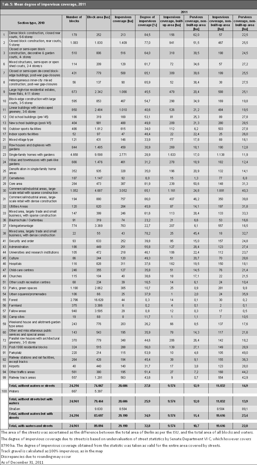
16 16

17 Tab. 5: Mean Degrees of Impervious Coverage per Section Type, 2011 For a better overview, the degrees of impervious coverage are also summarized for each land-use type (ISU categories). Residential areas have an average degree of impervious coverage of 39.5%. The core areas have the highest mean degree of impervious coverage, with 81.9%, while Forest and "Farmland" have the lowest. Tab. 6: Mean Degrees of Impervious Coverage by Land-use Type The statistical blocks and block segments of Berlin (without streets and waters) are 27.8 % impervious, on average. Of this, 12.9 % are accounted for by impervious built-up areas, and 14.9 % by impervious non-built-up areas. Including bodies of water and streets, Berlin is thus 32.8 % impervious. Of this, 10.7 % is accounted for by impervious built-up areas, and 12.4 % by impervious non-built-up areas. Impervious streets account for 9.6 % of the Berlin area. Berlin is thus one third impervious. The impervious area in turn consists of roughly equal parts of buildings, streets, and nonbuilt-up impervious areas (one third each). Impervious Coverage in the Boroughs For the borough-referenced evaluation, the average degree of impervious coverage of the road surfaces was calculated. For this purpose, statistics on the pavement and road surfacing of Berlin s streets, bicycle paths and sidewalks were evaluated (SenStadt 2006). 17

18 Fig. 7: Degree of Impervious Coverage by Borough (in Percentage of Total Area without Bodies of Water) The borough with the lowest degree of impervious coverage is Treptow-Köpenick, with 21.3 %, while Kreuzberg-Friedrichshain and Mitte have the highest degrees, with 68.7 and 62.7 %, respectively. These two boroughs also have the highest shares of built-up areas, as a proportion of their total areas. Data on Impervious Soil Coverage in 2011 Compared with 1990, 2001 and 2005 Due to different ascertainment methods, a direct comparison between the impervious coverage values of 1990 or 2001 with 2005 or 2011 is possible only to a limited degree. No change in the impervious area over the course of this period of time can be ascertained from these figures. In 2001, the degree of impervious coverage in Berlin amounted to 34.7 %, incl. streets and bodies of water. These data are to some extent based on evaluations of satellite images and other sources from the 80s (only in West Berlin). This mapping material was expanded to include East Berlin in 1990, and partially updated, in 2001 by means of aerial photography and topographical maps of the area. Here, use-specific flat values were assumed in some cases. Overall, the ascertainment methodology was non-uniform. The mapping projects of 2005 in 2011 now provide a data set gain from a uniform, completely automated and considerably improved procedure. The result is that the degree of impervious coverage in 2011 amounts to 32.8 %, and is thus approx. 0.9 % higher than the value for The major share of this increase in impervious coverage is accounted for by the non-built-up impervious areas. Tab. 7: Results of mapping of impervious coverage in Berlin, 1990 to 2011 Impervious coverage Built-up impervious areas Non-built-up impervious areas Streets Total area evaluated Number of blocks ha % ha % ha % ha % ha , , ,358 23, , , ,317 24, , , ,090 24, , , ,095 24,961 Discrepancies may occur, due to rounding 18
19 Tab. 7: Results of mapping of impervious coverage in Berlin, 1990 to (all information refers to the total area of Berlin, incl. streets and bodies of water). Due to changed evaluation methods, no change can be concluded for the entire period of time. The values for 1990 and 2001 are based on different evaluation methods, which do not permit any comparison with the values for 2005 and However, a comparison between 2005 in 2011 is possible. It is notable that the values ascertained for the impervious built-up area over the years are almost identical. This indicates that the old ascertainment methods yielded values that were quite good on the average, since the surveys of 2005 and 2011 using the ALK can be considered very precise. For the non-built-up impervious areas, the picture is somewhat different. Here, the values ascertained for 2005 decreased by 2.8 percentage points compared with 2001, and increased by 0.9% between 2005 in The decrease between 2001 and 2005 may on the one hand be due to the fact that on the old maps, some green and open-space categories (e.g. Forest and Farmland) were assigned estimated values for their non-built-up impervious portions, values which we today recognize as having been too high. Since these areas constitute a major share of the municipal area, the degree of impervious coverage was overestimated for the non-built-up impervious areas overall. On the other hand, due to the problems mentioned above regarding the interpretation of the satellite data, the non-built-up impervious areas were more likely to be underestimated under the new method. These assumptions are rather more plausible than the supposition that any reduction in impervious areas actually took place in the municipal area. With regard to the ascertainment of impervious roadways, the roughly estimated values available in 1990 could not be replaced by values from the Road-Building Authority until These were used for the evaluations in For the impervious coverage mapping projects in in 2005 and 2011, degrees of impervious coverage for streets, recorded by borough based on 2006 data, were obtained for the entire city (Gerstenberg & Goedecke 2011). A slight increase in the degree of impervious coverage attributable to the streets category and caused by road-building measures, primarily in East Berlin, certainly seems plausible. The multiple use of the new procedure in 2011 also permits a comparison with the impervious coverage at block level. Figure 8 maps the changes between 2005 in Blocks with changes of greater than 10 % of the degree of impervious coverage are shown. However, in the overall accounting of the impervious coverage in the total area and at the level of sector types, smaller changes have also been incorporated. Investigations during the development of the procedure showed that the ascertainment of the built-up impervious surface was very precise (cf. Validation 2007). For the ascertainment of the non-built-up impervious areas, the precision is not as good. This is due to the following reason: Due to the correction of ISU sector types in 2010, pseudo-changes occurred in 718 blocks. In the SPOT5 satellite image scene of 2005, there were much larger shaded areas than in These were classified specific to the surroundings. In the comparison, different impervious coverage values could even occur when using the same evaluation methods. For 244 block sectors, the block geometries was changed considerably between 2005 in 2010, causing pseudo-changes to appear in the impervious coverage map. For 37 block sectors, there were no SPOT5 satellite image scenes available in These sectors were entered into the comparison for 2005 as 0 % impervious. However, since most of them involved forest areas east of Müggel Lake, the error here must be considered minimal. For these reasons, only blocks with changes in overall impervious coverage of greater than 10 % are shown in the map of impervious coverage changes between 2005 in

20 Figure 8: Map of Changes in Impervious Coverage between 2005 in 2011 Excursus Comparison of the impervious coverage data for 2011 and 2005 with the Impervious Coverage Indicator of the Working Group on Integrated Environmental and Economic Accounting of the German States (EEAL; Ger.: UGRdL) The impervious coverage value for Berlin of the Working Group on Integrated Environmental and Economic Accounting of the German States (EEAL), developed by the Federal-State Commission on Soil Protection (LABO) on the bases of the sustainability indicator land consumption for residential/ commercial and traffic areas, is now juxtaposed to the results of the Environmental Atlas. The data survey of degrees of impervious coverage by state is based on official land statistics, in which estimated degrees of impervious coverage are assigned to various use categories of residential/ commercial and traffic areas, modified in accordance with residential density of the areas, and then used as a factor in calculation. In this way, impervious coverage data can be generated on an annual basis. The data on development of impervious coverage in the states are updated annually (EEAL 2010). Accordingly, the proportion of impervious coverage in the total area of Berlin rose from % in 2000 to % in 2010, and thus increased by 0.86 % in 10 years, which comes to an annual rate of 20

21 increase of 0.09 %. The absolute increase in impervious coverage was thus 770 ha during that tenyear period. Figure 9 shows the rate of impervious coverage of the Environmental Atlas in 2005 and 2011, compared with the annually generated data of the EEAL. Neither approach ascertains impervious coverage precisely; both work with different methods and different goals, and, to a certain extent, with estimates and assumptions, and are thus ultimately estimation methods. While the EEAL approach gives the current (2010) overall impervious coverage of Berlin as 35.1 %, the Environmental Atlas mapped only 32.8 % of the city as impervious in Under the procedure of the Environmental Atlas, the built-up impervious coverage area was derived directly from the ALK, and hence has a very high degree of precision, while the non-built-up impervious coverage area, as described above, is determined from satellite imagery. Hence, the above-mentioned error sources must be methodologically taken into account. By contrast, the EEAL approach operates from the outset with estimates for certain use classes, which are moreover nationally uniform, and hence do not take regional particularities into account. For instance, the elimination of the area of Tempelhof Airport for the category of traffic areas at the time of its closure led to a change in the statistical situation, in spite of the fact that nothing changed in real life. Figure 9: Degrees of impervious coverage shown in the Environmental Atlas, 2005 in 2011 Editions, compared with the annually generated data of the EEAL. For political decision-making, other impervious coverage data can also be used. The impervious coverage data of the EEAL is collected annually according to a fixed, nationally uniform comparison method, and is thus best suited for monitoring, and ultimately, too, has been developed precisely for that purpose. Due to the ability to differentiate between built-up impervious areas, non-built-up impervious areas, and impervious street surfaces, the Environmental Atlas figures complement and modify the figures of the EEAL data. For built-up impervious surfaces, a very high degree of precision can be assumed. Literature [1] AGU Arbeitsgemeinschaft Umweltplanung 1988: Extrapolation and incorporation of the impervious-coverage map of the Environmental Atlas into the spatial reference system of the Berlin Ecological Planning Instrument (ÖPB), by order of the Berlin Senate Department for Urban Development and the Environment, not published. 21
01.02 Impervious Soil Coverage (Sealing of Soil Surface) (Edition 2007)
 (Edition 2007)") Senate Department for Urban Development 01.02 Impervious Soil Coverage (Sealing of Soil Surface) (Edition 2007) Overview Data on impervious soil coverage are regularly used in the offices of the Berlin
Senate Department for Urban Development 01.02 Impervious Soil Coverage (Sealing of Soil Surface) (Edition 2007) Overview Data on impervious soil coverage are regularly used in the offices of the Berlin
06.07 Urban Structure Urban Structure differentiated (2011 Edition)
") Senate Department for Urban Development and the Environment 06.07 Urban Structure 06.08 Urban Structure differentiated (2011 Edition) Overview The effects of urban development upon the environment depend
Senate Department for Urban Development and the Environment 06.07 Urban Structure 06.08 Urban Structure differentiated (2011 Edition) Overview The effects of urban development upon the environment depend
Fire Mapping Chapter. Working Paper
 Fire Mapping Chapter Working Paper Version 1.0 as of September 2018 International Working Group on Satellite-based Emergency Mapping (IWG-SEM) Contents 1. FOREWORD... 3 2. IWG-SEM Fire delineation section...
06.07 Urban Structure Urban Structure Area Types Differentiated (2016 Edition)
") 06.07 Urban Structure 06.08 Urban Structure Area Types Differentiated (2016 Edition) Overview The effects of urban development upon the environment depend to a particular degree on the type and intensity
06.07 Urban Structure 06.08 Urban Structure Area Types Differentiated (2016 Edition) Overview The effects of urban development upon the environment depend to a particular degree on the type and intensity
Draft Impervious Cover Reduction Action Plan for West Long Branch Borough, Monmouth County, New Jersey
 Draft Impervious Cover Reduction Action Plan for West Long Branch Borough, Monmouth County, New Jersey Prepared for West Long Branch Borough by the Rutgers Cooperative Extension Water Resources Program
CaseStudy Climate-ADAPT. Stuttgart: combating the heat island effect and poor air quality with green ventilation corridors
 CaseStudy Climate-ADAPT Stuttgart: combating the heat island effect and poor air quality with green ventilation corridors Cover design: EEA Cover photo: EEA Layout: EEA Legal notice The contents of this
Edward R. Sajecki Commissioner of Planning and Building
 Corporate Report Clerk s Files Originator s Files CD.03.POR DATE: TO: FROM: SUBJECT: Chair and Members of Planning and Development Committee Meeting Date: February 27, 2012 Edward R. Sajecki Commissioner
CITY OF CLEVELAND GREEN DESIGN GUIDELINES
 CITY OF CLEVELAND GREEN DESIGN GUIDELINES SEPTEMBER 18, 2008 PROJECT COMPLIANCE PATH: 1. Approved master plan 2. Approved design district boundaries 3. Approved district design guidelines, Green design
Draft Impervious Cover Reduction Action Plan for West New York, Hudson County, New Jersey
 Draft Impervious Cover Reduction Action Plan for West New York, Hudson County, New Jersey Prepared for the Town of West New York by the Rutgers Cooperative Extension Water Resources Program March 29, 2017
STORMWATER MANAGEMENT CODES ANALYSIS RICHLAND COUNTY, SC SITE PLANNING ROUNDTABLE
 STORMWATER MANAGEMENT CODES ANALYSIS RICHLAND COUNTY, SC SITE PLANNING ROUNDTABLE Codes analyses for each subcommittee were completed to assist participants of the Richland County Site Planning Roundtable.
THE GARDEN CITY PLAN. City of St. Catharines Official Plan. City of St. Catharines
 THE GARDEN CITY PLAN City of St. Catharines Official Plan City of St. Catharines August 2010 APPROVAL INFORMATION This Official Plan of the City of St. Catharines Planning Area, known as the Garden City
HEALTH SCIENCES BUILDING REDEVELOPMENT PROJECT
 INTRODUCTION In recent years, the University of Cincinnati (University) has demonstrated a commitment to identifying and implementing sustainable goals and objectives throughout University s Uptown Campuses.
DESIGN REVIEW COMMITTEE AGENDA ITEM
 DESIGN REVIEW COMMITTEE AGENDA ITEM AGENDA DATE: DECEMBER 16, 2015 TO: THRU: FROM: SUBJECT: Chair McCormick and Members of the Design Review Committee Leslie Aranda Roseberry, Planning Manager Kelly Christensen
A Growing Community Rural Settlement Areas
 Town of Huntsville Official Plan Review - POLICY BACKGROUND PAPER A Growing Community Rural Settlement Areas BACKGROUND: In addition to the fully municipally-serviced Urban Settlement Area and the Hidden
ANALYSIS AND EVALUATION OF NATURE SPACE POTENTIAL IN PERI-URBAN SPACES USING REMOTE SENSING DATA AND GIS
 ANALYSIS AND EVALUATION OF NATURE SPACE POTENTIAL IN PERI-URBAN SPACES USING REMOTE SENSING DATA AND GIS Ellen BANZHAF UFZ-Centre for Environmental Research Leipzig-Halle, Permoserstr. 15, D-04318 Leipzig
06.05 Availability of Public, Nearresidential Green Spaces (Edition 2013)
") Senate Department for Urban Development and the Environment 06.05 Availability of Public, Nearresidential Green Spaces (Edition 2013) Overview Densely built-up urban space is characterized by high structural
Senate Department for Urban Development and the Environment 06.05 Availability of Public, Nearresidential Green Spaces (Edition 2013) Overview Densely built-up urban space is characterized by high structural
ATTACHMENT. To the west, north, and east of the block, primarily singlefamily detached residential patterns, with some townhouses, predominate.
 COMMENT / REVISION MATRIX (as of ) for Washington and Kirkwood Special GLUP Study "Plus" and Concept Plan 1 2 Resolve inconsistency between American Legion site area noted in Map 1 1.36 AC 1.29 AC and
PLANNED UNIT DEVELOPMENT & SUBDIVISION STAFF REPORT Date: May 18, 2017
 & PUD-0000102-2017 PLANNED UNIT DEVELOPMENT & SUBDIVISION STAFF REPORT Date: May 18, 2017 NAME SUBDIVISION NAME Dauphin Creek Estates Subdivision Dauphin Creek Estates Subdivision LOCATION CITY COUNCIL
Metropolitan Area Planning Council 60 Temple Place, Boston, Massachusetts fax
 Metropolitan Area Planning Council 60 Temple Place, Boston, Massachusetts 02111 617-451-2770 fax 614-482-7185 www.mapc.org Serving the 101 Cities Towns in the Metropolitan Boston Region MEMORANDUM TO:
B L A C K D I A M O N D D E S I G N G U I D E L I N E S for Multi-family Development
 B L A C K D I A M O N D D E S I G N G U I D E L I N E S for Multi-family Development Adopted June 18, 2009 This section of the Design and focuses on site planning and design guidance for new multi-family
Green Infrastructure and Low-Impact Development Technologies
 Green Infrastructure and Low-Impact Development Technologies The guiding principles of these technologies is to manage stormwater at their sources using natural means, and establish conditions so that
Saying Mahalo to Solar Savings: A Billing Analysis of Solar Water Heaters in Hawaii
 Saying Mahalo to Solar Savings: A Billing Analysis of Solar Water Heaters in Hawaii Jenny Yaillen, Evergreen Economics Chris Ann Dickerson, CAD Consulting Wendy Takanish and John Cole, Hawaii Public Utilities
Duplex Design Guidelines
 Duplex Design Guidelines Adopted by Council May 29, 2006 Prepared By: Table of Contents 1.0 Application and Intent 1 2.0 Areas of Application 2 3.0 Design Principles 3 4.0 Design Guidelines 4 4.1 Site
Analysis of Environs of 1000 New York Street, German Methodist Episcopal Church
 Item No. 3: L-14-00028 p.1 Analysis of Environs of New York Street, German Methodist Episcopal Church Step One Historical Significance and Context According to the application for Historic Landmark Designation,
ALBERTA FOREST PROTECTION THERMAL INFRARED PROGRAM
 ALBERTA FOREST PROTECTION THERMAL INFRARED PROGRAM Eleventh Biennial USDA Forest Service Remote Sensing Applications Conference Salt Lake City, Utah April 25 Ken Dutchak, P. Biol. Reconnaissance and Remote
Section 9 NEIGHBORHOOD DESIGN
 Section 9 NEIGHBORHOOD DESIGN City of Lancaster Comprehensive Plan D u n k i n, S e f k o & A s s o c i a t e s, I n c. NEIGHBORHOOD DESIGN INTRODUCTION There are many ways in which a neighborhood can
Draft. Impervious Cover Reduction Action Plan for Dunellen Borough, Middlesex County, New Jersey
 Draft Impervious Cover Reduction Action Plan for Dunellen Borough, Middlesex County, New Jersey Prepared for Dunellen Borough by the Rutgers Cooperative Extension Water Resources Program September 22,
PhD Candidate, Université Paris-Est (France) and Institut d Urbanisme de l ALBA - Univerité de Balamand (Lebanon) 2
 and Institut d Urbanisme de l ALBA - Univerité de Balamand (Lebanon) 2") Noushig Kaloustian 1, Youssef Diab 2, Benjamin Bechtel 3, Jürgen Ossenbrügge 3 1 PhD Candidate, Université Paris-Est (France) and Institut d Urbanisme de l ALBA - Univerité de Balamand (Lebanon) 2 Professor,
Noushig Kaloustian 1, Youssef Diab 2, Benjamin Bechtel 3, Jürgen Ossenbrügge 3 1 PhD Candidate, Université Paris-Est (France) and Institut d Urbanisme de l ALBA - Univerité de Balamand (Lebanon) 2 Professor,
3.10 LAND USE SETTING PROJECT SITE EXISTING LAND USE DESIGNATIONS AND ZONING. General Plan Land Use Designations.
 This section of the Draft EIR addresses the existing land uses on and adjacent to the project site and discusses the potential impacts of the proposed project on existing land uses. Key issues addressed
BLACK/HARMONY/FAREWELL CREEK WATERSHED EXISTING CONDITIONS REPORT CHAPTER 5 IMPERVIOUS SURFACES
 BLACK/HARMONY/FAREWELL CREEK WATERSHED EXISTING CONDITIONS REPORT CHAPTER 5 IMPERVIOUS SURFACES Draft November 2009 TABLE OF CONTENTS 1.0 INTRODUCTION... 3 2.0 STUDY AREA AND SCOPE... 4 3.0 METHODOLOGY...
Impervious Cover Reduction Action Plan for City of Vineland, Cumberland County, New Jersey
 Impervious Cover Reduction Action Plan for City of Vineland, Cumberland County, New Jersey Prepared for the City of Vineland by the Rutgers Cooperative Extension Water Resources Program May 23, 2016 Table
Attachment 1 TOWN OF NEW TECUMSETH. Manual for the Preparation of an Urban Design Report
 Attachment 1 TOWN OF NEW TECUMSETH Manual for the Preparation of an Urban Design Report July 2010 TABLE OF CONTENTS Background, Policy Framework and the Preparation of Urban Design Reports 1. Introduction
Introduction Post Construction Stormwater Management Performance Requirements
 Introduction Post Construction Stormwater Management Performance Requirements The primary objective of these Post Construction Stormwater Management Performance Requirements is to minimize the downstream
DETECTION AND MONITORING OF ACTIVE FIRES USING REMOTE SENSING TECHNIQUES
 DETECTION AND MONITORING OF ACTIVE FIRES USING REMOTE SENSING TECHNIQUES Source: Unknown n.d., http://www.hotrodsandclassics.net/featuredpictures/featurepictures2.htm. by Claire Riddell DETECTION AND MONITORING
Reported Fires in High-Rise Structures in Selected Occupancies with and without Automatic Extinguishing Systems by Extent of Smoke Damage
 Reported Fires in High-Rise Structures in Selected Occupancies with and without Automatic Extinguishing Systems by Extent of Smoke Damage Marty Ahrens Fire Analysis and Research Division National Fire
CROWD-SOURCED REMOTE ASSESSMENTS OF REGIONAL-SCALE POST-DISASTER DAMAGE
 Eleventh U.S. National Conference on Earthquake Engineering Integrating Science, Engineering & Policy June 25-29, 2018 Los Angeles, California CROWD-SOURCED REMOTE ASSESSMENTS OF REGIONAL-SCALE POST-DISASTER
APPENDIX A SIMPLIFIED APPROACH TO STORMWATER MANAGEMENT FOR SMALL PROJECTS. In West Sadsbury Township, Chester County, Pennsylvania
 APPENDIX A SIMPLIFIED APPROACH TO STORMWATER MANAGEMENT FOR SMALL PROJECTS In West Sadsbury Township, Chester County, Pennsylvania TABLE OF CONTENTS I. Introduction 3 II. Importance of Stormwater Management
Newcourt Masterplan. November Exeter Local Development Framework
 Newcourt Masterplan November 2010 Exeter Local Development Framework Background The Exeter Core Strategy Proposed Submission sets out the vision, objectives and strategy for the development of Exeter up
Chapter 1 - General Design Guidelines CHAPTER 1 GENERAL DESIGN GUIDELINES
 CHAPTER 1 GENERAL DESIGN GUIDELINES 1.0 INTRODUCTION This Publication has been developed to provide current, uniform procedures and guidelines for the application and design of safe, convenient, efficient
Town of Washington Master Plan & Regulatory Audit: Interim Results
 Town of Washington Master Plan & Regulatory Audit: Interim Results May 20, 2008 Presented by: 30 Bank Street Lebanon, NH 03766 www.uvlsrpc.org Introduction & Purpose Compare the Master Plan to the regulations
Smart City Governance URBIS Solutions. David Ludlow, Assoc. Professor European Smart Cities University of the West of England, Bristol
 Smart City Governance URBIS Solutions David Ludlow, Assoc. Professor European Smart Cities University of the West of England, Bristol Integrated smart city model Smart Mobility Services focused on decreasing
RESEARCH HIGHLIGHT. Technical Series Urban Heat Island Mitigation Measures and Regulations in Montréal and Toronto
 RESEARCH HIGHLIGHT May 2014 Technical Series 14-100 Urban Heat Island Mitigation Measures and Regulations in Montréal and Toronto INTRODUCTION The Heat Island Research Group of the Department of Geography
Catawba Area Plan Advisory Group
 Catawba Area Plan Advisory Group Meeting #3 Natural Environment, Part I September 23, 2008 Advisory Group Meeting #3 Welcome and Introductions Review Handouts Vision Statement GDP - Environment Draft Vision
Brine Generation Study
 DOE/WIPP 00-2000 Brine Generation Study April 2000 Waste Isolation Pilot Plant Carlsbad, New Mexico Processing and final preparation of this report was performed by the Waste Isolation Pilot Plant Management
Ancient Greek and Roman planners recognized the importance of centralized gathering spaces within urban
 TEAMS Competition 2014 Urban Green Space Design Introduction Ancient Greek and Roman planners recognized the importance of centralized gathering spaces within urban areas. Early Greek agora and Roman forums
Metropolitan Area Planning Council 60 Temple Place, Boston, Massachusetts fax
 Metropolitan Area Planning Council 60 Temple Place, Boston, Massachusetts 02111 617-451-2770 fax 614-482-7185 www.mapc.org Serving the 101 Cities and Towns in the Metropolitan Boston Region MEMORANDUM
2.1 Decision Making Matrix
 2.1 Decision Making Matrix The following decision-making matrix merges the elements of architectural and historical significance and current condition within the over-arching treatment recommendation of
Impervious Cover Reduction Action Plan for Hampton Township, Sussex County, New Jersey
 Impervious Cover Reduction Action Plan for Hampton Township, Sussex County, New Jersey Prepared for Hampton Township by the Rutgers Cooperative Extension Water Resources Program November 8, 2016 Table
STORMWATER UTILITY FREQUENTLY ASKED QUESTIONS
 STORMWATER UTILITY FREQUENTLY ASKED QUESTIONS What is Stormwater? Stormwater is water that falls to the ground during a precipitation event. When land is undeveloped or covered with vegetative surface,
Transportation Research Center
 Increasing Design Flexibility in the AASHTO Green Book Your Department Name Presentation to AASHTO Subcommittee on Design Doug Harwood, MRIGlobal July 2017 Transportation Research Center Resolution of
What is stormwater runoff? Why is it a problem? Available Financial Incentives for Stormwater BMP s Downspout Disconnection - up to $20
 What is stormwater runoff? Stormwater is any form of natural precipitation (including ice and snow melt) that flows across undeveloped or developed land. In a natural setting, a majority of the water seeps
Creating Complete Roadway Corridors:
 Creating Complete Roadway Corridors: The AASHTO Guide to Transportation Landscape Architecture and Environmental Design NCHRP Project 15-33 Status Report AASHTO Standing Committee on Design Technical Committee
114 Richmond Road Les Soeurs De La Visitation D'Ottawa. Community Discussion
 114 Richmond Road Les Soeurs De La Visitation D'Ottawa Community Discussion Overview of the Proposal Ashcroft s Vision The Development Proposal Ashcroft has released its proposal a for development (700+
Chapter 4 - Preparation of Stormwater Site Plans
 Chapter 4 - Preparation of Stormwater Site Plans The Stormwater Site Plan is the comprehensive report containing all of the technical information and analysis necessary for the City to evaluate a proposed
tinyan lee the hastings experience masterplan : hastings corridor individual design sustainable urbanism : the hastings corridor
 tinyan lee the hastings experience masterplan : hastings corridor individual design Research Context Managing urban growth in Burnaby has become an increasing challenge. Burnaby currently has an estimated
STORM WATER UTILITY FREQUENTLY ASKED QUESTIONS
 STORM WATER UTILITY FREQUENTLY ASKED QUESTIONS In 2007, the City Council adopted Ordinance No. 1155 establishing a storm water utility in the City. No fee structure was adopted at that time. The idea of
North York Community Council. Director, Community Planning, North York District. Ward No. 26, Don Valley West
 STAFF REPORT ACTION REQUIRED 85 Laird Drive Zoning Application - Final Report Date: December 18, 2007 To: From: Wards: Reference Number: North York Community Council Director, Community Planning, North
Keep the Rain, not the runoff! Residential Best Management Practice (BMP) Incentive Program Criteria
 Incentive Program Criteria") CleanSScapes Keep the Rain, not the runoff! Residential Best Management Practice (BMP) Incentive Program Criteria Howard County Office of Community Sustainability, 410-313-0678 CleanScapes Program, www.cleanwaterhoward.com
CleanSScapes Keep the Rain, not the runoff! Residential Best Management Practice (BMP) Incentive Program Criteria Howard County Office of Community Sustainability, 410-313-0678 CleanScapes Program, www.cleanwaterhoward.com
asphalt applications European Asphalt Standards and their application in the UK mpa asphalt Asphalt Information Service Mineral Products Association
 asphalt applications 12 European Standards and their application in the UK Information Service mpa asphalt November 2009 Mineral Products Association PD 6691 and the BS EN 13108 series Wherever a reference
Draft. Impervious Cover Reduction Action Plan for Fair Haven, Monmouth County, New Jersey
 Draft Impervious Cover Reduction Action Plan for Fair Haven, Monmouth County, New Jersey Prepared for Fair Haven by the Rutgers Cooperative Extension Water Resources Program June 10, 2016 Table of Contents
WINDSOR GLEN DESIGN GUIDELINES
 WINDSOR GLEN DESIGN GUIDELINES Adopted by Council, 2006 WINDSOR GLEN REDEVELOPMENT DESIGN GUIDELINES August 2006 1.0 Master Plan Organization For this area of the Coquitlam Town Centre, a mix of high,
This Review Is Divided Into Two Phases:
 Semiahmoo Town Centre Review The purpose of this review: To review the Semiahmoo Town Centre Concept Plan, originally approved in 1993, to ensure that this centre will continue to serve the needs of South
Semi-automated extraction of Landscape Features from VHR satellite data
 Semi-automated extraction of Landscape Features from VHR satellite data Lukas Brodsky, Katerina Jupova, Lubos Kucera GISAT www.gisat.cz lukas.brodsky@gisat.cz Goals and motivations Landscape Features:
Can Short Term ARRA Stimulus Funding Achieve Long Term Market Transformation? 1
 Can Short Term ARRA Stimulus Funding Achieve Long Term Market Transformation? 1 Jane Colby, Cadmus Group, Boulder, CO Scott Davis, Cadmus Group, Boulder, CO ABSTRACT The New York Energy $mart SM Products
Urban Design Brief. Watson Parkway North & Watson Road North Guelph, Ontario. Prepared by Coletara Development
 Urban Design Brief Watson Parkway North & Watson Road North Guelph, Ontario Prepared by Coletara Development December, 2013 Urban Design Brief, Coletara Development 1 Introduction This Urban Design Brief
City of Redlands Architectural Guidelines for Non-Residential Development
 14. Building articulation shall be included in the design of building, in order to create a formal entry statement. Avoid this Do this Page 11 15. Give special attention to creating pedestrian scale and
Implemented by. Integrated Resource Management in Asian Cities: the Urban NEXUS
 Implemented by Integrated Resource Management in Asian Cities: the Urban NEXUS 10/12/2013 Page 1 The Governance Dimension of the Urban Nexus: Integrated Spatial Planning as Essential Condition for Sound
CHAPTER 7: VISION AND ACTION STATEMENTS. Noble 2025 Vision Statement
 CHAPTER 7: VISION AND ACTION STATEMENTS This chapter presents the vision, policy and action statements that transform the comprehensive planning study, an analysis of Noble s past, future trends and community
CONTENTS 8.0 LAND USE 8.1 GENERAL LAND USE 8.2 RESIDENTIAL 8.3 MIXED USE 8.4 COMMERCIAL 8.5 EMPLOYMENT LANDS
 8-2 Land Use 8.0 LAND USE CONTENTS 8.1 GENERAL LAND USE 8.1.1 Uses provided for in all Land Use Designations 8.1.2 Uses prohibited in Hazardous Lands, Hazardous Sites and Special Policy Areas 8.1.3 Uses
County of Fairfax, Virginia
 County of Fairfax, Virginia To protect and enrich the quality of life for the people, neighborhoods, and diverse communities of Fairfax County DATE: July 16, 2007 TO: SUBJECT: All Architects, Attorneys,
Zagreb. Strategic planning. City of Zagreb City Office of Strategic Planning and Development of the City
 Zagreb http://www.zagreb.hr/ Strategic planning Through ZAGREBPLAN a vision of Zagreb was defined: City of Zagreb as an urban incubator of sustainable concepts, entrepreneurship and new values City of
DESIGN REVIEW COMMITTEE AGENDA ITEM
 DESIGN REVIEW COMMITTEE AGENDA ITEM AGENDA DATE: OCTOBER 17, 2012 TO: Chair Woollett and Members of the Design Review Committee THRU: FROM: SUBJECT: Leslie Aranda Roseberry, Planning Manager Daniel Ryan,
6 PORT SYDNEY SETTLEMENT AREA
 Section 6 Port Sydney Page 61 6 PORT SYDNEY SETTLEMENT AREA 6.1 Basis and Principles Village of Port Sydney Waterfront Community Existing Services 6.1.1 Port Sydney is an historic settlement that has developed
Appendix D - Technical Design Criteria for BMPs
 Appendix D - Technical Design Criteria for BMPs City of Wayzata Page 3 On-site infiltration features Definitions and Scope: Infiltration facilities are constructed basins or depressions located in permeable
PLANNING BOARD HEARING Miami Shores Village Town Hall Council Chambers NE 2 nd Avenue Miami Shores Workshop Date April 24, 2014
 MIAMI SHORES VILLAGE DEPARTMENT OF PLANNING & ZONING 10050 NE 2 nd Avenue Miami Shores FL 33037-2304 www.miamishoresvillage.com David A. Dacquisto AICP, Director dacquistod@miamishoresvillage.com Main
COMMUNITY SUSTAINABILITY AND ENVIRONMENTAL MASTER PLAN IMPLEMENTATION UPDATE
 Attachment 1 COMMUNITY SUSTAINABILITY AND ENVIRONMENTAL MASTER PLAN IMPLEMENTATION UPDATE Priorities and Key Initiatives Committee May 2013 Page E-1 How we grow Goal 2: To ensure sustainable development
V-5 TREE PROTECTION AND LANDSCAPING REQUIREMENTS
 V-5 TREE PROTECTION AND LANDSCAPING REQUIREMENTS V-5.1 General A. Intent: It is the intent of this section to establish protective regulations for trees within the City of Milton, in order to better control
J. Paul Guyer, P.E., R.A.
 J. Paul Guyer, P.E., R.A. Paul Guyer is a registered civil engineer, mechanical engineer, fire protection engineer, and architect with over 35 years experience in the design of buildings and related infrastructure.
Colchester Northern Gateway Master Plan Vision Review Draft. July 2016
 Colchester Northern Gateway Master Plan Vision Review Draft July 2016 Contents Introduction 4 Context 8 Purpose of the Report 8 Strategic Position 9 Overview of the Process 11 2012 Master Plan Vision 12
ONTARIO MUNICIPAL BOARD
 PL 120483 ONTARIO MUNICIPAL BOARD Applicant/Appellant: 2124123 Ontario Limited Subject: OPA, Rezoning and Draft Plan of Subdivision Municipal Address: 3940 Highway 7 East Municipality: City of Markham
F. Driveways. Driveways which provide access to off-street parking or loading from public streets shall comply with the following:
 Section 20.945.040 General Design Standards for Surface Parking Areas. A. Review Authority. Parking lot design and drainage shall be subject to review and approval of the City Transportation Manager. B.
HUDSON VALLEY REGIONAL COUNCIL 3 Washington Center, Newburgh NY
 PROJECT AREA: HYDE PARK HUDSON VALLEY REGIONAL COUNCIL 3 Washington Center, Newburgh NY 12550 http://www.hudsonvalleyregionalcouncil Insert aerial site photo with streets labeled GREEN INFRASTRUCTURE CONCEPT
TOWN OF HILLSBOROUGH SAN MATEO COUNTY
 TOWN OF HILLSBOROUGH SAN MATEO COUNTY Planning Division 650/375-7422 Fax: 650/375-7415 1600 Floribunda Avenue Hillsborough California 94010 Administrative Review of Landscape Plans April 2017 WHAT TYPES
Description of Preferred Alternative
 Chapter 2 Description of Preferred Alternative 2.1 Introduction This chapter of the programmatic Sammamish Town Center Sub-area Plan Final EIS provides a more detailed description of the Preferred Alternative
Chapter 10 IMPLEMENTATION RECOMMENDATIONS
 Chapter 10 IMPLEMENTATION RECOMMENDATIONS The recommended land use plan presented in the previous chapter provides a design for the attainment of the urban and rural development and open space preservation
Strasbourg SUMP Award: Finalist factsheet. Local Transport facts. Urban transport policy objectives of the city:
 Strasbourg 2013 SUMP Award: Finalist factsheet Local Transport facts Name of the authority: Urban Community of Strasbourg, FR Website: www.strasbourg.eu Contact: Maeva Moreau Telephone: +33 388436514 Email:
STORM WATER MANAGEMENT PLAN APPLICATION Manheim Borough
 STORM WATER MANAGEMENT PLAN APPLICATION Manheim Borough DATE Application is hereby made to Manheim Borough for the issuance of a Storm Water Management Plan approval pursuant to the Manheim Borough Storm
Page 19 L.L.C. (Previously the United Salad Co. Garage) 939 SE Alder St.
 939 SE Alder St.") Page 19 L.L.C. (Previously the United Salad Co. Garage) 939 SE Alder St. Project Summary Project Type: Technologies: Major Benefits: Light industrial retrofit (parking lot) - demonstration project Landscape
Page 19 L.L.C. (Previously the United Salad Co. Garage) 939 SE Alder St. Project Summary Project Type: Technologies: Major Benefits: Light industrial retrofit (parking lot) - demonstration project Landscape
CITY CLERK. Parkland Acquisition Strategic Directions Report (All Wards)
") CITY CLERK Clause embodied in Report No. 10 of the, as adopted by the Council of the City of Toronto at its meeting held on November 6, 7 and 8, 2001. 10 Parkland Acquisition Strategic Directions Report
CITY CLERK Clause embodied in Report No. 10 of the, as adopted by the Council of the City of Toronto at its meeting held on November 6, 7 and 8, 2001. 10 Parkland Acquisition Strategic Directions Report
DESIGN REVIEW COMMITTEE AGENDA ITEM
 DESIGN REVIEW COMMITTEE AGENDA ITEM AGENDA DATE: OCTOBER 3, 2012 TO: Chair Woollett and Members of the Design Review Committee THRU: FROM: SUBJECT: Leslie Aranda Roseberry, Planning Manager Daniel Ryan,
Chapter 19.5 LANDSCAPING REQUIREMENTS
 Chapter 19.5 LANDSCAPING REQUIREMENTS Sec. 19.5-1. Intent The intent of the landscaping requirements stated herein are as follows: To aid in stabilizing the environment's ecological balance by contribution
Highway Alignment and Route Location Survey
 CHAPTER 2 Highway Route Surveys and Location Introduction To determine the geometric features of road design, the following surveys must be conducted after the necessity of the road is decided. Type of
CITY OF HOLLY SPRINGS STORMWATER UTILITY FREQUENTLY ASKED QUESTIONS
 CITY OF HOLLY SPRINGS STORMWATER UTILITY FREQUENTLY ASKED QUESTIONS GENERAL What is a Stormwater Utility and why is it needed in Holly Springs? A Stormwater Utility is an entity responsible for the daily
CHAPTER 11 SITE DESIGN AND LOW IMPACT DEVELOPMENT
 CHAPTER 11 SITE DESIGN AND LOW IMPACT DEVELOPMENT Source: City of Bend Chapter Organization 11.1 Purpose... 11-1 11.2 Applicability... 11-1 11.3 Low Impact Development Overview... 11-2 11.3.1 Key Strategies...
Homeowners Guide to Stormwater BMP Maintenance
 Homeowners Guide to Stormwater BMP Maintenance What You Need to Know to Take Care of Your Property Rain Barrel Dry Well Rain Garden Pervious Asphalt Porous Pavers City of El Monte Stormwater BMP Management
Swatara Township Stormwater Program. 1. There are no storm sewers on or near my property. Why should I pay a fee?
 1. There are no storm sewers on or near my property. Why should I pay a fee? All properties produce stormwater runoff that must be managed by the Township. Even if your property has never flooded and there
DRAFT DESIGN GUIDELINES
 IHZ Booklet #7 May 6, 2010 DRAFT DESIGN GUIDELINES CANTERBURY 7 Overview During the recent planning process for the Plan of Conservation and Development community character was identified as an important
CITY OF CYPRESS 5275 Orange Avenue Cypress, California (714) DESIGN REVIEW COMMITTEE PERMIT PROCESS
 DESIGN REVIEW COMMITTEE PERMIT PROCESS") CITY OF CYPRESS 5275 Orange Avenue Cypress, California 90630 (714) 229-6720 DESIGN REVIEW COMMITTEE PERMIT PROCESS 1. Discuss project with Planning staff to determine zoning regulations, any unusual characteristics
CITY OF CYPRESS 5275 Orange Avenue Cypress, California 90630 (714) 229-6720 DESIGN REVIEW COMMITTEE PERMIT PROCESS 1. Discuss project with Planning staff to determine zoning regulations, any unusual characteristics
Lecture: Landscape Ecology
 Borderland: Border Landscapes Across Europe 2013 Lecture: Landscape Ecology Dr Iwona Markuszewska Department of Landscape Ecology iwmark@amu.edu.pl Presentation schedule: Landscape ecology as a scientific
VILLAGE OF SKOKIE Design Guidelines for Mixed-Use Districts NX Neighborhood Mixed-Use TX Transit Mixed-Use CX Core Mixed-Use
 VILLAGE OF SKOKIE Design Guidelines for Mixed-Use Districts NX Neighborhood Mixed-Use TX Transit Mixed-Use CX Core Mixed-Use TABLE OF CONTENTS CHAPTER 1 SITE DESIGN Purpose 1 CHAPTER 2 SITE DESIGN Streetscape