DISCLAIMER. 3/11/13 Gregory P. Humora City Engineer, Director of Public Works. Revised 03/11/13
|
|
|
- Loraine Preston
- 5 years ago
- Views:
Transcription
1
2 City of La Mesa Tree Policy Manual DISCLAIMER The City of La Mesa Tree Policy Manual was prepared and developed as a guide for City departments and divisions that will be involved with the review of landscape design and maintenance of trees within the City. This is the most current version of the City s Tree Policy Manual. It may not be fully adequate to address all aspects of tree maintenance. Therefore, it is prudent for the applicable City department members and outside design professionals to avail their best professional experience and good judgment is using the information in this document. The City of La Mesa makes no warranty either expressed or implied as to the accuracy or reliability of the information contained in this 2012 version of the City of La Mesa Tree Policy Manual. Effective July 28, 1987, by Resolution No , the City of La Mesa adopted as policy the San Diego Regional Standard Drawings as the design standards governing development within the City of La Mesa s jurisdiction. The design guidelines presented here are only meant to supplement the Regional Standard Drawings; where conflict arises between these guidelines and the Regional Standard Drawings, the City of La Mesa Standard Drawings shall take precedence. 3/11/13 Gregory P. Humora Date City Engineer, Director of Public Works Revised 03/11/13
3 City of La Mesa Tree Policy Manual TABLE OF CONTENTS SECTION 1: PURPOSE SECTION 2: AUTHORITY AND POWER SECTION 3: APPLICABILITY SECTION 4: DEFINITIONS SECTION 5: TREE PLANTING, MAINTENANCE AND REMOVAL Street Tree Program Installation Removal Tree Replacement Care And Maintenance After Planting Trimming Of Street Trees Root Pruning Standards And Specifications SECTION 6: ADJACENT LANDOWNER RESPONSIBILITY Responsibility Procedure References SECTION 7: TREE PROTECTION Preservation Protection New Developments TOC 1 Revised 3/11/13
4 City of La Mesa Tree Policy Manual TABLE OF CONTENTS (Continued) SECTION 8: LANDSCAPING Landscape Standards Zoning Requirements Tree Related Land Use Guidelines Site Design Landscape Design Off Street Parking Design Visually Sensitive Areas Safety Design SECTION 9: PERMITS SECTION 10: TREE CITY U.S.A History Policy Web Link SECTION 11: OTHER Open Spaces And Landscaping Specific Plans Additional Tree Related Requirements TOC 2 Revised 3/11/13
5 City of La Mesa Tree Policy Manual EXHIBITS EXHIBIT I EXHIBIT II EXHIBIT III EXHIBIT IV EXHIBIT V City of La Mesa Tree Planting Specifications; LS 1, LS 2 Approved Street Tree List & Specifications Right Of Way Tree Maintenance Handout Notice of Liability For Tree Hazard Tree Planting & Maintenance Agreement EXHIBIT VI Ordinance No EXHIBIT VII La Mesa Tree Policy, Adopted November 14, 1989 APPENDICIES APPENDIX I APPENDIX II City Maintained Street Tree Inventory Downtown Village Specific Plan APPENDIX III Harry Griffen Park Xeriscape and Trails Project Specification APPENDIX IV Landscape Standards APPENDIX V Urban Design Overlay Zone APPENDIX VI Mixed Use Overlay Zone Design Guidelines TOC 3 Revised 3/11/13
6 City of La Mesa Tree Policy Manual SECTION 1: PURPOSE The purpose of this manual is to provide a reference for existing City of La Mesa guidelines, policies and standards for the planting, care, preservation, maintenance, replacement and removal of trees within the public right of way and on private property. The goal is the preservation of existing trees wherever feasible and their replacement when removal is necessary. This manual is also to be used as a reference guide for planting new trees, and to provide rules in the exercise of the City's authority to remove encroachments when deemed necessary for public safety and welfare within the City of La Mesa. (Tree Policy, Adopted November 14, 1989, Section II Purpose) References made in this manual have been extracted from existing documents governing and pertaining to planting, caring for and maintaining trees and landscaping throughout the City. Individual users of this manual should consult the complete documents referenced for specific and comprehensive information. 1 1 Revised 3/11/13
7
8 City of La Mesa Tree Policy Manual SECTION 3: APPLICABILITY The scope of this policy is intended to cover only those trees and other landscaping located within or which encroach into the public right of way. Trees or landscaping located entirely within private property shall be subject to the provisions of the appropriate sections of the City Municipal Code. (Tree Policy, Adopted November 14, 1989, Section I Scope) 3 1 Revised 3/11/13
9 City of La Mesa Tree Policy Manual SECTION 4: DEFINITIONS A. Street Tree: Any tree located within the City street right of way. These may be located in parkways, behind sidewalks, or in cases where there is no sidewalk, in the space between the edge of pavement or curb and the property line. Exception: Trees planted as a condition of approval of a development entitlement and which are designated as the adjacent property owner's responsibility to maintain. (Tree Policy, Adopted November 14, 1989, Section III Definitions) B. Parkway: The strip of land located within 10 feet from face of curb; generally between face of curb and the sidewalk or back of sidewalk and City street right of way. (Tree Policy, Adopted November 14, 1989, Section III Definitions) C. Street right of way: That area owned by the City and used for street purposes, extending between property lines on either side of the street. Paralleling or adjacent easements identified for utilities are not considered as street right of way for purposes of this policy. (Tree Policy, Adopted November 14, 1989, Section III Definitions) D. Exterior Architectural Feature: The architectural style, design, general arrangement, components and natural features and all the outer surfaces of the improvement, including, but not limited to, the kind and texture of the building material, the type and style of all windows, doors, lights, signs, walls, fences, and other fixtures appurtenant to such improvement, and the natural form and appearance of but not by way of limitation, any grade, rock, body of water, stream, tree, plant, shrub, road, path, walkway, plaza, fountain, sculpture, or other form of natural or artificial landscaping. (Municipal Code Section (g)) 4 1 Revised 3/11/13
10 City of La Mesa Tree Policy Manual SECTION 5: STREET TREE PROGRAM: TREE PLANTING, MAINTENANCE AND REMOVAL The City maintains an inventory of all trees within the public right of way for which the City is responsible for continual maintenance, (See Appendix I). Any additions, deletions or substitutions to the existing inventory should be documented. I. STREET TREE PROGRAM: A. Street Tree Requirements 1. Street trees shall be planted at a minimum of one 15 gallon tree per 40 feet of linear street frontage. Trees may be placed on center or clustered in groups, dependent on the prevailing pattern in the neighborhood. (For requirements within the Mixed Use Overlay Zone, refer to Appendix VI.) 2. Trees shall be placed a minimum of 10 feet from all traffic signals, stop signs, utility poles, street lights, fire hydrants or transformer enclosures. 3. A root barrier such as bio barrier shall be installed per manufacturer s specifications for all trees within 5 feet of a public sidewalk. 4. Trees shall be selected and maintained so that upon maturity a minimum distance of 7 feet clear is maintained between the finish grade and the lower branches. 5. Trees shall be specified from the approved street tree list for final approval by the Director of Public Works. II. INSTALLATION: A. The City maintains an inventory of all trees within the public right of way which the City is responsible for maintenance. (See Appendix I.) When a property owner desires to replace an existing tree or add additional trees along their property frontage within the public right of way the following policy shall be adhered to: 1. The property owner shall sign a Tree Planting and Maintenance Agreement for continued maintenance of the tree. (See Exhibit VI.) 2. A property owner may request that City forces do the work. Trees being planted at the request of the property owner are performed on a first come first serve basis. 5 1 Revised 3/11/13
11 City of La Mesa Tree Policy Manual 3. The property owner may perform the work themselves but replacement of an existing tree that requires tree removal shall be done in accordance with provisions set forth in this manual. 4. Prior to beginning the work, the property owner should contact the City and obtain an Encroachment Permit to perform work within the public right of way, and provide a sketch of their property frontage showing locations of existing and proposed tree locations, driveway location, distance off of curb face, adjacent property lines, utility locations and any other facilities that may conflict with the tree locations. 5. All trees should be free of insects, pests, or fungus disease. They should have normally well developed branch systems and a vigorous and fibrous root system, which is not root or pot bound. 6. Trees shall be staked or guyed until they are self supporting. (See LMSD LS 1 and Tree Planting & Staking, Exhibit I.) 7. See Section V through VIII, below, for care and maintenance. B. Final Approval 1. Upon completing the installation of the landscaping and irrigation system, the developer, contractor, or landscape architect shall submit a letter to the Director of Public Works stating that all landscaping, irrigation, drainage, and hardscape was installed according to City standards and per specifications and details of the approved plans. This letter shall also note any significant changes to either the planting or irrigation plans which were made during installation. Receipt of this letter and final inspection by the Department shall be required prior to final occupancy being granted for the project. Any trees added by new development will be added to the City s asset inventory by the Land Development Mgr. III. REMOVAL: A. Street trees shall only be removed by the City or duly authorized agents of the City. In certain cases, removal will be permitted by others but only upon approval by the Director of Public Works and an encroachment permit is obtained from the City. Removal by others shall be subject to all the conditions contained in the encroachment permit. Removal by either the City or others will be allowed only when one of the following has occurred: (Tree Policy, adopted November 14, 1989, Section IV Tree Removal #1 8 p.2) 5 2 Revised 3/11/13
12 City of La Mesa Tree Policy Manual 1. The tree is dead. 2. The tree is damaged, diseased, or infested beyond the point of saving using reasonable horticultural practices, or should be removed to prevent the spread of disease or infestation. 3. The tree is uprooted and a hazard. 4. The tree is damaging improvements such as pavement, curb and gutter, and sidewalk, and all options such as root pruning, re routing of improvements around the tree, or other methods which may become available, have been considered but deemed infeasible. 5. The tree is damaging private improvements and methods described in number 4 above are not feasible. 6. The tree is deemed by the Department of Public Works to be a substantial hazard to traffic or pedestrians, and all other reasonable alternatives are deemed infeasible. 7. The tree is noxious, a public nuisance or is otherwise a safety or health risk. Property owner dislike or dissatisfaction with a particular street tree shall not be grounds for removal, unless strong medical or other reasons are documented to the satisfaction of the Public Works Superintendent. 8. Root intrusion into a private sewer lateral shall not be grounds for removal of a tree. Root intrusions shall be handled in a manner consistent with the revised sewer lateral maintenance policy adopted December 24, B. Tree Removal By Utility Company A utility company may request removal of a tree if it has determined that the tree is interfering with and has the potential to disrupt utility service. A utility wishing to remove a tree shall perform the following prior to removing the tree: 1. Inform the City in writing which tree it would like to remove and the reasons for requesting removal. 2. If the City approves the request for removal then the Utility shall: a. Send a letter to the property owner(s) informing them that the tree will be removed and the reasons why. b. Propose a replacement tree and location to the City and property 5 3 Revised 3/11/13
13 City of La Mesa Tree Policy Manual owner(s). c. Have the property owner(s) execute a tree maintenance agreement if a new tree is installed. (See Exhibit VI.) d. Remove the old tree and stump. e. Plant new tree. C. Where tree stumps are removed, the City will be responsible only for backfilling the hole with topsoil. The City will not be responsible for replacing surface improvements such as decorative brick, ground cover, or other treatments which previously existed around the tree. Improvements replaced by the property owner shall be done in a manner acceptable to the City Engineering Division. (Tree Policy, adopted November 14, 1989, Section IV Tree Removal p. 2) D. The owner or resident of the property at which a street tree is to be removed shall be notified a minimum of one week in advance of the removal, except in the case of an emergency so deemed by the Superintendent of Public Works. (Tree Policy, adopted November 14, 1989, Section IV Tree Removal p. 3) E. Except where removal by others is approved, all cleanup and removal of debris, brush, and wood shall be the responsibility of the City. (Tree Policy, adopted November 14, 1989, Section IV p. 3) F. Emergencies may require immediate action on an individual tree basis. The Superintendent of Public Works shall determine whether an emergency exists. (Tree Policy, adopted November 14, 1989, Section VII Trimming of Street Trees p. 3) G. For replacement of removed trees, see Section IV Tree Replacement, below. IV. TREE REPLACEMENT: A. Trees will be replaced when: (Tree Policy, adopted November 14, 1989, Section V Tree Replacement) 1. The property owner signs the tree maintenance agreement. 2. The property owner purchases the tree and all related materials necessary to plant the tree in accordance with Exhibit I. 3. The original tree was destroyed as the result of some action, such as an auto accident, from which recovery of costs may be made by the City. 5 4 Revised 3/11/13
14 City of La Mesa Tree Policy Manual B. Trees will not be replaced at locations where deemed inappropriate by the Director of Public Works due to inadequate space, sight distance or other problems. C. The method of the planting (Exhibit I) and the list of approved street trees (Exhibit II) may be amended by the Director of Public Works from time to time as experience or technology dictates. In areas of special landscaping, such as median islands or other street landscaped areas, trees of other species may be planted that are appropriate for the space available. (Tree Policy, adopted November 14, 1989, Section V Tree Replacement p.3) D. Plant materials that have deteriorated or died shall be replaced with healthy plantings, or the area should be redesigned and replanted with other landscape treatments to provide an attractive and equivalent appearance. (Urban Design Program Streetscape D(4) p. 67) V. CARE AND MAINTENANCE AFTER PLANTING: A. Resource limitations make it impractical for City forces to provide continual care for newly planted trees. Adjoining property owners will be responsible to provide water to the tree, and to report tree distress if any should occur. Homeowners will be required to enter into a maintenance agreement for care of the tree, (See Exhibit VI). Written watering instructions along with a contact phone number, will be provided by the City. (Tree Policy, adopted November 14, 1989, Section VI Care and Maintenance After Planting) B. Trees should be maintained to ensure water efficiency. A regular maintenance schedule should include, but not be limited to: checking, adjusting, and repairing irrigation equipment; resetting the automatic controller; aerating and dethatching turf areas; replenishing mulch; fertilizing; pruning; and, weeding in all landscaped areas. (See Water Efficient Landscape Regulations, Appendix 4.) C. Watering should be scheduled between the hours of 2:00 AM and 10:00 AM to avoid irrigating during times of high wind or high temperature. Deep watering practices shall be utilized to promote deep rooting of trees and shrubs. D. Trees and shrubs should be trimmed or pruned to prevent blocking or interference with the following: 1. Sight distance views; no shrubs shall be allowed to exceed 36 in height when planted within parkways. Tree canopy shall not extend below; 7 in height over sidewalks or 14 feet in height over public streets and alleys. (Refer to LMSD LS 1; Tree Planting & Staking, (See Exhibit I) and LMFD Fire Code Section ) 2. Pedestrian or motor vehicle access. 5 5 Revised 3/11/13
15 City of La Mesa Tree Policy Manual 3. Installation, maintenance or repair of any public utility or fire lane. 4. Damage to property line fences or structures on adjoining properties. E. All landscaped areas shall be regularly watered, fertilized, weeded and otherwise kept in good condition. F. The City will be responsible for pruning, and chemical treatment for insects. (Tree Policy, adopted November 14, 1989, Section VI Care and Maintenance After Planting), R.O.W. Tree maintenance Handout (See Exhibit IV.) G. Plantings must be kept watered, fed, cultivated, and pruned as required to give a healthy and well groomed appearance during all seasons. Planting areas should be periodically weeded and cleaned. (Urban Design Program Streetscape D(5) p. 67) VI. TRIMMING OF STREET TREES: A. Trimming of street trees shall be the responsibility of the City Public Works Department, either by City forces or by private contract. Scheduling shall generally be by Maintenance Zones so as to give a uniform appearance to neighborhoods. The City is divided into seven (7) maintenance zones. One zone shall be pruned each year and maintenance shall rotate through the zones in numerical and clockwise order around the City. Tree and root pruning shall be followed by repairs to concrete hardscape then asphalt concrete public improvements. (See Exhibit IV). (Tree Policy, adopted November 14, 1989, Section VII Trimming of Street Trees) B. Regular trimming will consist of providing a minimum clearance of 7 feet above sidewalks, and 14 feet above the street or alley. Trees will be thinned out and or have their crowns reduced. Traffic control signs or other warning devices shall be kept clear of growth, with good visibility provided to motorists. (Tree Policy, adopted November 14, 1989, Section VI Trimming of Street Trees and LMFD Fire Code Section ) C. SDG&E will be notified of trees growing into electrical wires. That agency will normally provide trimming necessary for their facilities only. The City will provide other trimming as necessary. (Tree Policy, adopted November 14, 1989, Section VII Trimming of Street Trees) VII. ROOT PRUNING: A. PURPOSE The purpose of the root pruning policy is twofold: 1. To provide guidelines for root pruning that will protect the health of the tree; 5 6 Revised 3/11/13
16 City of La Mesa Tree Policy Manual and 2. To reduce safety hazards and damage to property caused by aggressive tree roots. B. OBJECTIVES 1. To reduce future root problems by implementing a proper planning and assessment process. 2. To develop root pruning practices and guidelines. 3. To provide a process for correcting existing root problems that is a threat to public safety or is causing property damage. 4. To train and instruct staff in the methods of root growth control. 5. To develop a communication link with other City departments whose operations are affected by aggressive tree roots. C. DEFINITIONS 1. Root Pruning The practice of removing a portion of a tree's root system. 2. Root Pruner A machine that cuts roots up to a depth of half a meter 1½ feet below grade level. 3. Tree A woody plant with one or more stems and a minimum diameter width of 1 inch and a minimum height of 4 feet. D. RESPONSIBILITY 1. The Park Maintenance Supervisor has the overall responsibility for implementing the root pruning guidelines. 2. The Park Maintenance Supervisor is responsible for coordinating the root pruning operations. 3. The Park Maintenance Supervisor is responsible for training staff. 4. Approval of the Park maintenance Supervisor or Engineering Division is required before any tree root over four inches in diameter is pruned. Any tree root with a diameter of less than four inches can be pruned without the approval of the Parks Supervisor. 5 7 Revised 3/11/13
17 City of La Mesa Tree Policy Manual E. PROCEDURE 1. All new planting locations shall be assessed by the appropriate Parks or Engineering Division personnel to avoid creating future root problems for the site. In order to prevent tree root problems created by using inappropriate trees for the site, The Approved Parkway Street Tree List shall be followed by all persons planting trees on public land. 2. Applicants applying for a building permit whose construction activities will require a public tree to be root pruned shall be advised to contact the Parks Supervisor. 3. All new construction projects shall be jointly assessed by the Parks Supervisor and the contractor to determine if there is a need to do any root pruning before work commences. The contractor is required to notify Department of Public Works a minimum of two weeks in advance so that any root pruning can be completed before the work commences. 4. The Park Maintenance Supervisor shall conduct an on site assessment of the root pruning work required. 5. The Park Maintenance Supervisor shall schedule a crew/contractor to do the root pruning required. The work shall be done in accordance with the root pruning guidelines described in Section G, below. 6. The Park Maintenance Supervisor is responsible for conducting ongoing site assessments while the project is occurring. This is to ensure that no additional roots are cut by the contractor without the approval of The Department of Public Works. 7. In cases where a tree on public property must be root pruned to accommodate a private development, the cost of the root pruning shall be billed to the proponent of the project. 8. Contractors or private property owners performing unauthorized root pruning on public trees resulting in instability to the tree or its subsequent demise shall be billed for any expenses incurred in remedying the situation or replacing the tree. An assessment of all affected trees shall be conducted within two years of the project completion to determine the effectiveness of the root pruning and if any additional work will be required. The Park Maintenance Supervisor will determine any follow up work needed. 5 8 Revised 3/11/13
18
19 City of La Mesa Tree Policy Manual approval of the Park Maintenance Supervisor. 6. Roots must not be removed from more than one side of the tree in any given year. 7. All excavation holes are to be covered with a wet tarp and kept moist for the duration of the construction project to protect the roots from desiccation. 8. Root barriers shall be used in association with root problems adjacent to concrete and asphalt walkways. (Refer to LMSD LS 1, Tree Planting Policy for root barrier installation. (See Exhibit I.)) 9. Root control barriers may be used in those sites deemed appropriate. 10. Should the Park Maintenance Supervisor determine that root pruning will not alleviate the problem then the tree may be rated as a hazard tree and subsequently recommend for removal. (See Section 5: Street Tree Planting, Maintenance and Removal, Subsection III Removal.) 11. Top soil shall be used to backfill the excavation area. 12. Root pruning of surface roots shall only occur if the level of the surrounding surface cannot be raised. 13. No root pruning will occur within six feet of a tree without the approval of the Park Maintenance Supervisor. The installation of any utilities within the six foot zone shall be by auguring a trench under the tree. VIII. STANDARDS AND SPECIFICATIONS: A. See Section 8 LANDSCAPING, Subsection V Landscape Design, p to B. See Tree Planting Specifications, (Exhibit I) C. See Approved Street Tree List, (Exhibit II) D. See Tree List Color Exhibit, (Exhibit III) 5 10 Revised 3/11/13
20 City of La Mesa Tree Policy Manual SECTION 6: ADJACENT LANDOWNER RESPONSIBILITY I. RESPONSIBILITY A. The area commonly referred to as the parkway between the public right of way and the improved street, excluding sidewalk, shall be maintained by the adjacent property owner. B. Unless otherwise agreed to, trees within the public right of way shall be trimmed by the city. C. Unless otherwise agreed to, trees within the parkway shall be trimmed by the city. D. Trees within the public right of way or the parkway shall be watered and fertilized as necessary by the adjacent property owner. E. The maintenance of trees and landscaping located on private property adjacent to the public right of way shall be the responsibility of the property owner II. PROCEDURE A. Parkway improvements shall be approved by the city. B. Parkways are to be properly maintained. Plant material shall be healthy. Weeds shall be removed. Plants or vegetation shall not encroach into the street or the sidewalk as this could create a hazard. Debris from parkways shall not encroach into the street or the sidewalk. C. To reduce storm water pollution and runoff, parkways are not to be paved with asphalt, concrete or other impervious material. They may be landscaped with plants, mulch, decomposed granite, pavers or other pervious material. D. Sidewalks shall have a minimum of a 7 foot high clearance from all trees and vegetation. It shall be the property owner s responsibility to maintain height clearances. (See Exhibit I.) E. Encroachment and Obstructions: 1. Where trees on private property encroach into the public right of way and are determined to be in need of trimming because they are affecting the safety of the general public, the property owner shall be notified in writing to perform designated trimming within 10 days. If not done within the specified period, City forces will perform the trimming, but only as necessary to remove the endangerment. No special shaping or trimming will be performed. The City will dispose of all trimmings. The 6 1 Revised 3/11/13
21 City of La Mesa Tree Policy Manual property owner will be billed for the City's costs in performing the work and accept all risk and liability associated with the trimming even after the work has been performed. (Tree Policy, adopted November 14, 1989, Section VIII Privately Owned Street Trees) 2. In case of a private tree falling across the public right of way, the Public Works Department will take immediate action to clear the obstruction back to the property line and off the right of way. The wood from this type of removal will be cut into handling lengths and given to the property owner only if the property owner requests. The property owner will be billed for the City's costs in performing the work and accept all risk and liability associated with the trimming even after the work has been performed. (Tree Policy, adopted November 14, 1989, Section VIII Privately Owned Street Trees) F. See Section 5 TREE PLANTING, MAINTENANCE AND REMOVAL, Subsection III Removal (C), p G. Streets shall have a minimum of a 14 foot high clearance from all trees and vegetation. It shall be the property owner s responsibility to maintain height clearances. (See Exhibit I.) H. Trees and vegetation shall not affect site distance as this could create a hazard. It shall be the property owner s responsibility to maintain site distances. (See Exhibit V Sight Distance Requirements At Corners.) I. City staff spends a considerable amount of time responding to complaints regarding vegetation encroachments from height clearance and site distance. It is the property owner s responsibility to remove these encroachments. If a complaint is received regarding an encroachment, the city will investigate the complaint. If the investigation finds that the encroachment complaint is valid, a letter will be issued to the property owner requesting removal of the encroachment within a specified time period. If the encroachment is not removed as requested the city may perform the removal with its own or contact forces and may seek reimbursement of all associated costs from the property owner. III. REFERENCES A. California Streets and Highways Code, Section 5610 The owners of lots or portions of lots fronting on any portion of a public street or place when that street or place is improved or if and when the are between the property line of the adjacent property and the street line is maintained as a park or parking strip, shall maintain any sidewalk in such condition that the sidewalk will not endanger persons or property and maintain it in a condition which will not interfere with the public convenience in the use of those works or areas save and except as to those conditions 6 2 Revised 3/11/13
22 City of La Mesa Tree Policy Manual created or maintained in, upon, along, or in connection with such sidewalk by any person other than the owner, under and be virtue of any permit or right granted to him be law or by the city authorities in charge thereof, and such persons shall be under a like duty in relation thereto. B. La Mesa Municipal Code, Chapter 24.11, Urban Design Overlay Zone (D) 6 3 Revised 3/11/13
23 City of La Mesa Tree Policy Manual SECTION 7: TREE PROTECTION The following excerpts are extractions from the La Mesa General Plan. For the complete core of policies which govern the physical development and growth of La Mesa including policies which govern new development, redevelopment and the maintenance of property, consult the La Mesa General Plan in its entirety. I. PRESERVATION: A. The City values trees for their role in processing carbon dioxide in the atmosphere, and will continue efforts to save existing trees and to require planting of new trees in conjunction with public and private developments. (La Mesa General Plan Conservation and Open Space Element Conservation Policies #5 p. 3) B. The Community Development Department will review the Zoning Ordinance to consider what standards can be added to preserve and protect stands of mature trees within the City. (La Mesa General Plan Conservation and Open Space Element Conservation Objectives #2 p. 4) C. The Community Development Department and the Public Works Department shall review the current standards for street trees and landscaping in the right of way to insure that the plant varieties and quantities specified are adequate. (La Mesa General Plan Conservation and Open Space Element Conservation Objectives #3 p. 4) The following page contains excerpts from Chapter 9.08 of the La Mesa Municipal Code and the City s General Plan. For the complete set of rules governing parks and recreation areas, please consult Chapter 9.08 of the La Mesa Municipal Code in its entirety. For a comprehensive list of La Mesa s historic landmarks, please consult Appendix A of the City s General Plan. II. PROTECTION: A. It is unlawful for any person to do any of the acts herein specified within the exterior boundary lines of any park or recreation area in the city: 1. To cut, break, injure, deface or disturb any tree, shrub, plant, rock, building, fence, bench, table, or other structures, apparatus or property; or to pluck, pull up, cut, take or remove any shrub, bush, plant, or flower; or to mark or write upon, paint or deface in any manner, any building, monument, fence, bench, or other structure. (La Mesa Municipal Code Section ) (Ord (part); March 14, 1972) 7 1 Revised 3/11/13
24 City of La Mesa Tree Policy Manual III. NEW DEVELOPMENTS: A. See Section 8 LANDSCAPING, Subsection I Landscape Standards, C Landscape Design Plans (2h), p.5 4. B. Also see Section 8 LANDSCAPING, Subsection II Zoning Requirements, A Limitations on Permitted Uses and Structures (1), p C. Also see Section 8 LANDSCAPING, Subsection IV Site Design, p Revised 3/11/13
25 City of La Mesa Tree Policy Manual SECTION 8: LANDSCAPING Pages 8 1 to 8 6 of this manual contain excerpts from the City of La Mesa Landscape Standards. Individual users should refer to the City of La Mesa Landscape Standards in its entirety for more specific information governing new and rehabilitated landscaping for certain projects. I. LANDSCAPE STANDARDS: A. The regulations and guidelines listed in these Landscape Standards adopted by the La Mesa City Council are intended to achieve the following goals: 1. Promote the values and benefits of landscapes while recognizing the need to invest water and other resources as efficiently as possible. 2. Establish a structure for designing, installing, and maintaining water efficient landscapes in new projects. 3. Establish provisions for water management practices and water waste prevention for established landscapes. B. Properties Subject to Landscape Standards 1. These standards shall apply to all new and rehabilitated landscaping for the following projects: a. Public agency projects. b. Private industrial and commercial projects. c. Multiple unit residential projects and developer installed landscaping in single family residential projects. 2. These standards shall not apply to landscaping by homeowners in single family residences. C. Review Process 1. Landscape Plan Review a. Prior to the issuance of a building permit, landscape and irrigation plans must be submitted to the Community Development Department Building Division for approval. The property owner or his agent shall submit two copies of the landscape and irrigation plans. Building permits will not be 8 1 Revised 3/11/13
26 City of La Mesa Tree Policy Manual issued without an approved set of landscape and irrigation plans. b. Projects subject to site plan review or design review shall provide conceptual landscape plans including a Water Conservation Information Package with the initial application. D. Landscape Design Plans 1. General Landscape Design Requirements a. Each project shall contain a brief description of the project and the design elements that are intended to achieve conservation and efficiency in water use. b. The landscape plan shall be designed to achieve architectural and environmental enhancement in the following areas: 1. Screening of parking, storage areas, and unsightly objects such as public utilities and substations. 2. Creating buffer zones between residential, commercial and industrial areas. 3. Erosion control. 4. Wind and noise barriers. 5. Streetscape enhancement. 6. Improving the relationship of site to structure through the use of shade, screening, accent, and foundation plantings. 2. Landscape Plan Design a. Plant materials should be selected for their ability to withstand drought conditions. The following xeriscape principles should be incorporated into the planting design: 1. Plant materials with low water requirements should be utilized. 2. Plants with similar water requirements should be grouped together on the same irrigation system. 3. Native plants should be utilized when applicable and for transitional 8 2 Revised 3/11/13
27 City of La Mesa Tree Policy Manual zones. 4. All shrub and ground cover areas (excluding lawns and slopes over 3:1) should be top dressed with a minimum of 2" depth shredded bark mulch to retain soil moisture. 5. The use of lawns shall be limited to conserve water. b. All areas should be provided with a mixture of groundcover, shrubs, and trees. Trees shall generally be in minimum 15 gallon containers and shrubs in 5 gallon containers, except where approved by the Community Development Department (or by the Public Works Department where appropriate). c. At least one tree shall be provided for every 500 square feet of landscaped area (except in public parks, subject to approval by the Public Works Department). A minimum of 20% of the trees shall be specimen size (i.e., in 24" box or larger containers). Additional trees may be required for screening or to provide vertical scale as a requirement of the Design Review process. d. Plant spacing shall be determined by the average mature size of the plant. Flats and liners shall be spaced at a maximum of 12" on center, triangular spacing. e. Planting or suitable non living groundcover (i.e., bark chips, mulch, etc.) shall be required in all areas not developed by buildings, parking, or hardscape. f. Shrubs over 36" in height (at maturity) shall not be permitted within a 15 foot sight distance triangle at the intersection of the public right of way, or within 15 feet of the intersection of any ingress or egress driveway and the public right of way. g. Non living groundcover such as bark or stone may be used, but shall not cover more than 30% of any landscape area. h. Existing mature trees should be preserved and incorporated into the landscape design wherever feasible and appropriate. 3. Specifications and Details a. Planting plans shall include botanical and common names of plant materials, symbols, size, quantity, and spacing. 8 3 Revised 3/11/13
28 City of La Mesa Tree Policy Manual b. The name, address, phone number and license number of the person or firm who prepared the plans. Either a licensed landscape architect or licensed landscape contractor shall prepare plans for projects with over 1,000 square feet of landscaping area. For smaller projects, a person familiar with the proposed species of plants, irrigation systems, and water conservation principles shall prepare the plans. c. The plans shall include the details for the installation of trees and shrubs, including details for the staking and guying of all trees. d. The following minimum information shall be included on the plans: E. Erosion Control For Slopes 1. Property lines, easements, locations of utilities, the result of approved construction (i.e. buildings, pavement, pools, rock outcroppings, walls, fences, planters, lighting, etc.). The existing or proposed curbs, gutters, sidewalks or edge of pavement, street name(s), scale, north arrow, site address, etc. (Minimum scale = 20'). 2. The location, type and caliper size of any existing mature trees to remain, to be relocated, or to be removed. If mature trees are removed due to grading or other reasons, replacement specimen size trees may be required. 1. All newly graded slopes at a gradient of 4:1 or greater; in excess of 3 feet vertical height shall be landscaped with groundcover from flats which is known to have soil binding characteristics to control erosion. Groundcover shall be planted at a rate to achieve complete coverage in the first year. Jute matting, or other similar erosion control material, shall be installed on all slopes. Hydro seed may be substituted for groundcover plantings if it is shown that the hydro seed area will achieve 100% coverage in the first year. 2. Slopes in excess of 5 feet vertical height shall be irrigated with a permanent irrigation system and planted with a combination of trees, shrubs and groundcovers to prevent erosion of soil. 3. Slope planting and irrigation shall be installed and operative before the final inspection by the Public Works Department. F. Fire Protection / Brush Management 1. Plantings of low fuel volume and low to moderate fire retardant characteristics 8 4 Revised 3/11/13
29 City of La Mesa Tree Policy Manual shall be required in high fire hazard areas. 2. Regular maintenance of new and existing plantings shall include pruning and thinning to eliminate dead or excessive fuel, and provide adequate space between shrubs and structures. G. Graffiti Prevention 1. Landscaping shall be installed to provide screening of blank building or retaining walls to discourage graffiti. A dense row of trees or vines, which climb to cover blank wall areas, shall be utilized. In addition, shrubs that exhibit thorns may also be utilized to inhibit access to the wall area. The landscaping should be designed to provide substantial coverage of the wall within a one year period after installation. The following are excerpts from Chapter 24, Zoning, of the La Mesa Municipal Code. Please consult Chapter 24.09, Scenic Preservation Overlay Zone (P), of the La Mesa Municipal Code for complete information governing established regulations for the recognized scenic areas within the city, the character of which could be permanently damaged by action involving the development and use of land without special regulation to prevent or mitigate such damage. For comprehensive information concerning development standards for Brier Crest Tract, refer to Chapter of the La Mesa Municipal Code. II. ZONING REQUIREMENTS: A. Scenic Preservation Overlay Zone (P) All uses and structures permitted in the underlying zone shall be subject to the same conditions and restrictions of such zone and the following: (Municipal Code Section (A), (B) & ) 1. The improvement of the building site either initially or after a principal use has been established shall not involve alteration of the surface of the land by construction, excavation, filling, or otherwise, through which trees would be removed, water courses would be altered, or earth banks exceeding 3 feet in height would be created unless the development is first submitted to and approved by the Planning Commission. 2. Insofar as feasible, natural topography, vegetation, and scenic features of the site shall be retained and incorporated into each proposed development. The design of the foundation and structure for each proposed building shall accommodate the natural terrain with minimal grading. 8 5 Revised 3/11/13
30 City of La Mesa Tree Policy Manual 3. All building sites shall be landscaped and maintained. In connection with each proposed development a landscaping plan shall be submitted with application for building permit. Such plan shall show location, size, and type of all trees proposed to be removed together with the size, location, and type of all trees proposed for replacement. All specimen trees shall be replaced with healthy trees also of specimen size except where this requirement is relieved by the Planning Commission upon justification. B. Brier Tract Overlay Zone (BT)* (Municipal Code Section (a)(c)) In order to maintain the rustic atmosphere of the Brier Tract the following development standards shall apply in addition to those of the underlying zone: 1. Streets: All streets shall conform to the Brier Tract standards for rural roads. Note: The standard below is intended to be a flexible standard. A 40 right ofway is required with an 18 travel way and an 8 parking bay. When designing the street the City Engineer shall vary the location of the travel way within the right of way so as to avoid trees and other environmental disruptions. 2. Landscaping: Regardless of any other standard, four trees shall be required on every lot within the Brier Tract Overlay zone. Two of the required four trees shall be placed in the front setback area and the required trees shall be not less than ten feet high and three inches in girth. The following excerpts are extractions from the La Mesa General Plan. For the complete core of policies which govern the physical development and growth of La Mesa including policies which govern new development, redevelopment and the maintenance of property, consult the La Mesa General Plan in its entirety. III. TREE RELATED LAND USE GUIDELINES: A. Land Use Goal 1. To create a network of mixed use transportation corridors throughout the City by transforming El Cajon Boulevard, Fletcher Parkway, La Mesa Boulevard, Spring Street and University Avenue into tree lined civic boulevards accommodating a mix of high volume retailers, professional offices, financial centers and moderate density residential projects. (General Plan Land Use & Urban Design Element Land Use Goal #7 p. 8) B. Land Use Policy 8 6 Revised 3/11/13
31 City of La Mesa Tree Policy Manual 1. Methods to preserve natural features of the land, including mature stands of trees and topographic features should be incorporated in new residential development standards. (General Plan Urban Design Element Policies Residential #18 p. 25) C. Urban Design Policy 1. New development shall be designed to enhance as well as maintain the natural features of a site. Removal of major rock outcroppings, trees or other natural features through grading or the construction processes will be avoided. (General Plan Land Use & Urban Design Element Urban Design Program #6 p. 40) D. Fire Safety Design 1. Fire safety in developed areas shall be increased through a program of plant materials management, including weed abatement on vacant land, and the replacement of flammable vegetation with less flammable plant materials. (General Plan Safety Element Fire Safety Landscape Buffers p. 39) 2. Around undeveloped and open space areas the selective clearing and thinning of overgrown vegetation reduces fire risk. Native chaparral species as well as nonnative grass species are relatively less fire resistant. Replacement plantings using fire resistant species along the interface between developed and undeveloped areas reduces wild land fire hazard. (General Plan Safety Element Fire Safety Responses to Fire Hazards p. 23) Pages 8 9 through 8 13 contain excerpts from the City of La Mesa s Urban Design Program. Please refer to Chapter 24.11, Urban Design Overlay Zone (D) of the La Mesa Municipal Code and the Urban Design Program for the specific requirements for all new development and major renovations or remodeling of property within the Urban Design Overlay Zone. This zone is used to supplement the required land use regulation that are reviewed under the standard provisions of the Zoning Ordinance. IV. SITE DESIGN: A. Natural site amenities should be recognized and be considered as strong site design determinants. Canyons, rock outcroppings, views, trees and similar features unique to the site should be preserved and incorporated into development proposals. (Urban Design Program Development Guidelines Site Design #4 p. 31) 8 7 Revised 3/11/13
32 City of La Mesa Tree Policy Manual V. LANDSCAPE DESIGN: La Mesa has been nationally recognized as a Tree City for its concern and dedication to the maintenance and preservation of our urban landscape. All site development should include a well thought out and executed landscape plan. The Design Review Board encourages innovation in planting design and choice of landscape materials. (Urban Design Program Development Guidelines p. 37) A. Existing Vegetation Healthy existing vegetation and natural rock formations should be kept an incorporated into site and landscaping plans if they improve the site s appearance or enhance its proposed use and function. B. Landscape Design There should be a consistent landscape design throughout a development. Unrelated choice or placement of plant materials should be avoided. Different landscape themes may be utilized in larger developments, where it may help to heighten the distinction between spaces and to strengthen a sense of movement or place, as long as such themes are internally consistent. Landscaping should use a combination of trees, shrubs, and ground cover. A project s planting should blend with vegetation on nearby property if the neighboring greenery is healthy and appropriate. C. Plant Purposes 1. Walls: Shrubs and scrubby trees can be grouped densely together to form substantial hedges and walls. Such use of shrubs can range from 4 to 8 feet in eight and be maintained in very formal or natural forms depending on the appropriateness of the plant materials. Tall shrubs and small trees can also extend this landscape for up to heights of 8 20 feet where appropriate. 2. Ceilings: Moderate to very full trees can be used singly or in groups as an umbrella or canopy to form landscape ceilings. These can serve to provide privacy, climate control, control erosion, and define a hierarchy of spatial organization, structure, or function. D. Plant Selection Healthy and well maintained plant materials should be used in all landscaped areas. Thickness, height, color, seasonal characteristics and ultimate growth should always be considered. 1. Where planting is intended to perform a function such as screening or shading, its initial size and spacing must be selected to achieve its purpose within two years, or else it should be supplemented by temporary architectural features such as street fencing or an arbor. The use of indigenous or native type plant materials is encouraged. (Urban Design Program Development Standards Development Guidelines #1 12 p. 37) 8 8 Revised 3/11/13
33 City of La Mesa Tree Policy Manual E. Landscaping Scale and Nature The scale and nature of landscaping materials should be appropriate to the site and/or structure. Large scale buildings generally should be complemented landscaping with similar scale and proportions. Where a site, structural or circulation hierarchy exists, the landscape plan should enhance the definition of use and function. For example, where shade is desired, broad spreading canopy type trees are appropriate, or landscaping of sites on major streets should include large scale trees. F. Existing Landscape Elements Existing landscape elements should be incorporated into landscape plans. Mature trees and tree groupings as well as rock outcroppings should be considered as design determinants and clearly shown on all plans submitted. G. Street Trees Street trees should be considered a required landscape element for all projects unless otherwise directed by the City. Street trees should be 15 gallon size or larger, and should complement the existing street trees or the City s street tree plan for the area. Use of ornamental type trees as street trees is discouraged unless deemed appropriate. H. Ground Cover Ground cover should be of live plant materials. I. Parking Areas All parking areas should be landscaped. Planting and landscaping should be provided at suitable intervals throughout the lot and at the ends of parking rows, and should screen parked cars from adjacent streets. It should include trees that will provide adequate visual interest and shading when they mature. The planting must not block a driver s view. J. Placement Plants should be placed with respect to their life cycles attention should be given to their ability to maintain and reproduce, achieve their size at maturity and their expected life span. Placement also should respect the various environmental requirements of different plants including such factors as temperature, moisture, soil, sunlight, and wind. K. Energy Conservation Solar accessibility and utility should be a determinant of landscape design: dense, tall screen type landscaping along northerly property lines should be avoided where solar access may be appropriate on adjoining properties. Deciduous trees on the southerly and westerly side(s) of buildings may help reduce overall energy consumption as well. L. Planting Sizes A variety of plant sizes are encouraged at the time of installation with the following minimum standards as general guidelines: Trees: 1¾ inch caliper, 6 foot height M. Protection for Planters Planting areas adjacent to parking areas, drives, or walks must be protected by concrete curbing where necessary. 8 9 Revised 3/11/13
34 City of La Mesa Tree Policy Manual N. Planting Types Where possible, landscaping and vegetation should be native and drought resistant or tolerant. Choice of fire retardant plants is also required in canyon areas. VI. OFF STREET PARKING DESIGN: (Urban Design Program Development Guidelines Off street Parking Design p. 42) A. Parking Area Element 1. Concrete curbing around all landscaped areas in order to contain landscape material and to protect landscaping from automobiles. B. Parking Design Off street parking areas should be designed and landscaped so as to minimize the visual impact of large paved areas. Parking areas should include the following elements: 1. Landscaping in and around the paved area to meet the City s Parking and Landscape Standards. Generally, trees, shrubs, and ground cover should be incorporated in peripheral areas. 2. Both perimeter and interior landscaping of canopy type trees: the location and spacing of trees is dependent on type of tree used, but the overall effect should be of a relatively consistent tree cover which will shade the pavement and autos. VII. VISUALLY SENSITIVE AREAS: (Urban Design Program Visually Sensitive Areas #14 p. 19) A. La Mesa is making a conscious attempt to create a physical environment which is well landscaped. All parking areas shall be screened from public streets with landscaping and decorative screening walls. Interior yards need not be landscaped unless required by the Board. However, all parking lots shall be landscaped with ground cover, shrubs, and trees for shade. Landscape arrangement should provide for safe pedestrian/vehicular orientation. Plantings should be selected and placed to reinforce and enhance pedestrian scale and character along street frontages. Trees that provide shade canopies or seasonal color are encouraged. B. Major Circulation Corridors: Fletcher Pkwy., El Cajon Blvd., University Ave., La Mesa Blvd. east of University Ave. The community, new projects, and redevelopment (where feasible) should provide for visual characteristics which strengthen the image of the corridor and the streetscape through such features as street trees programs, landscaped areas, sign programs, appropriate site design and architecture, and removal of visually disruptive elements. The following specific guidelines are applicable to development 8 10 Revised 3/11/13
35 City of La Mesa Tree Policy Manual occurring along these major circulation corridors: (Urban Design Program Visually Sensitive Areas p. 20) 1. Street Trees The provision of street trees and live vegetation within the rightof way is significant in strengthening a corridor s image. The City encourages the use of street trees and planting in the space between the street and sidewalk (park strip) rather than replacement with paving materials. Preservation of all existing mature trees within the street right of way and on private property where visible from the street is encouraged. (Urban Design Program Visually Sensitive Areas #4 p. 22) 2. Street Furniture The location of street furniture along corridors and adjacent to major intersections is very desirable and should be included in new projects which encompass this need. By including amenities, such as trash receptacles, benches, public mailboxes, telephone booths, and street trees or landscaping can greatly enhance the pedestrian environment and give greater function and amenity to these areas. (Urban Design Program Visually Sensitive Areas #6 p. 22) 3. Landscaping Adjacent to Freeways Because CALTRANS does not provide adequate vegetation along all freeway areas the City and property owners must also assist in creating and maintaining landscape areas in these corridors. Landscaping adjacent to the freeway right of way would be similar in nature to the existing and adjacent landscaping of the freeway and should provide trees and ground cover wherever visible. Care in the integration of the project and freeway topography should be provided. (Urban Design Program Visually Sensitive Areas #13 p. 24) VIII. SAFETY DESIGN A. Barriers to Police In semi public and semi private areas barriers, which would hinder police patrol, such as confused parking patterns and tall shrubs, should be avoided. Plant materials such as high shrubs should not be located so that surveillance of semi public and semi private areas is blocked. Sticker shrubs may discourage crime activities. Low shrubs and umbrella trees (where the canopy is maintained above five feet from the ground) will allow surveillance opportunities, hence reducing the potential for criminal behavior. (Urban Design Program Development Guidelines Safety Design #11 p. 48) 8 11 Revised 3/11/13
36 City of La Mesa Tree Policy Manual SECTION 9: PERMITS The following are excerpts from the La Mesa Municipal Code Chapters and For additional information regarding permits for street work, please consult Chapter of the La Mesa Municipal Code. For specific information pertaining to design and construction, please see Chapter of the La Mesa Municipal Code in its entirety. A. An encroachment permit is required for any work being performed within the public right of way by non city personnel, inclusive of planting, maintaining or removing any trees growing in the public right of way. (Municipal Code Section (e)) B. Nothing contained in a utility franchise agreement shall empower a grantee to cut or trim any trees in any street, alley or public highway, but grantee may cut or trim trees pursuant to a prior agreement with the owner of property on which they stand, or as otherwise authorized in writing by grantor. (Municipal Code Section ) (Ord (part); March 23, 1993) See Section 8 LANDSCAPING, Subsection I Landscape Standards, B Review Process (1a), p See Section 5 TREE PLANTING, MAINTENANCE AND REMOVAL, Subsection I Removal (A), p Revised 3/11/13

37 City of La Mesa Tree Policy Manual SECTION 10: TREE CITY U.S.A. I. HISTORY: The Tree City USA program, sponsored by the Arbor Day Foundation in cooperation with the USDA Forest Service and the National Association of State Foresters, provides direction, technical assistance, public attention, and national recognition for urban and community forestry programs in thousands of towns and cities that more than 120 million Americans call home. La Mesa has been nationally recognized as a Tree City for its concern and dedication to the maintenance and preservation of our urban landscape. The City of La Mesa has been designated as a Tree City USA by the National Arbor Day Foundation since 1980 and is currently recognized as the longest standing City within San Diego County to achieve this designation. II. POLICY: There are four standards a community must comply with to be Tree City USA qualified: A. The City must have a Tree Board or Forestry Department: Ordinance amends Section of the La Mesa Municipal Code, amending the administrative responsibilities of the Development Advisory Board to include serving as the City Tree Board. The DAB shall consist of the Community Development Director, City Engineer, Building Division Director, Associate Engineer, and Fire Marshal. When acting as the City Tree Board the Public Works Superintendent shall also be a voting member. (Municipal Code Section (G), Ordinance No (See Appendix A)) B. The City must have a local tree ordinance: Ordinance amends Section of the La Mesa Municipal Code, providing for the adoption of a Tree Policy Manual. C. The City must spend $2 per capita on tree maintenance: 10 1 Revised 3/11/13
38 City of La Mesa Tree Policy Manual Fiscal year 2011 budget numbers were $327,360. The number of City residents is currently 56,881. Dividing the budget amount by the number of residents gives you the amount spent per capita of $5.75. D. The City must promote Arbor Day: Each year during the second week of March the Mayor and the City Council sign a proclamation designating the week as Arbor Week where citizens are encouraged to celebrate Arbor Week and support efforts to protect our trees and woodlands and support the City s tree planting programs. III. WEBLINK: A. To view the City s website information regarding approved street tree lists, tree maintenance agreements, policies, or to report a problem please follow this link; B. To view the National Tree City U.S.A. website information please follow this link; Revised 3/11/13
39 City of La Mesa Tree Policy Manual SECTION 11: OTHER The following excerpts have been extracted from City of La Mesa project area plans. Please see Attachments 1 through 3 for complete redevelopment plans. References made to trees and tree related guidelines and standards can be found in the following references. Please see the plans in their entirety for more complete information. I. SPECIFIC PLANS: A. Downtown Village Specific Plan B. Harry Griffin Park Xeriscape and Trails C. Alvarado Creek Redevelopment Project, Environmental Impact Report II. OPEN SPACES AND LANDSCAPING: Landscaping plans shall be submitted to the Agency for review and approval to ensure optimum use of living plant material. (Excerpt from Alvarado Creek Redevelopment Plan [Sec 516] p. 22; Amended Redevelopment Plan for the Central Area Redevelopment Project [Sec 519] p. 15; Fletcher Parkway Redevelopment Project [Sec 517] p. 16.) III. ADDITIONAL TREE RELATED REQUIREMENTS: A. No news rack shall be placed, installed, used or maintained within three feet of, or on any public area improved with lawn, flowers, shrubs, trees or other landscaping. (Municipal Code ( )) B. The responsibility for landscaping park areas, direction and assistance to workmen engaged in planting and caring for lawns, trees, shrubs, and flowers and maintenance of all parks, shall be under the supervision of the Director of Public Works of the City. (Municipal Code Section ) (Ord (part); March 14, 1972) 11 1 Revised 3/11/13
40
41

42

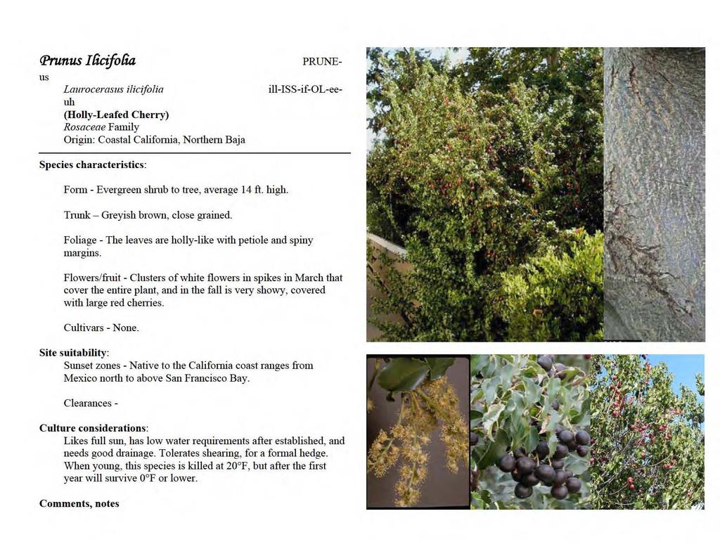
43 APPROVED STREET TREES February 15, 2010

44
45

46

47
48
49
50
51
52
53
54

55
56
57
58
59
60
61
62
63 Right-of-Way Tree Maintenance Along with being responsible for the maintenance of public parks and traffic island landscape, the Park Maintenance Division of the Public Works Department is also responsible for the maintenance of over 8,156 trees planted throughout the City including the public rights-ofway. This maintenance includes scheduled and emergency tree trimming and removal. Removal Of Existing Trees: Removal of existing trees is caused by many factors including death of the tree, hazardous conditions and damage to surrounding improvements including sidewalks, curb and gutter and pavement. This work is done by the City or a duly authorized agent. Removal by others is permitted only with the approval of the Director of Public Works and a street encroachment permit. (Tree Policy Manual Section 6) Replacement of Removed Trees: Selection of the correct tree for a specific location is extremely important. The wrong tree would not grow properly and may cause damage to infrastructure. Removed trees are replaced following several guidelines such as adequate space for planting, clear traffic sight lines and locations of existing utilities. Replacement trees are selected from an approved tree list Once the location is decided, the selected tree is planted by City crews or authorized agents. The list of approved trees and the method of planting may change over time due to changing standards and practices. (Refer to Tree Policy Manual, Exhibit III for a current list.) Care and Maintenance after Replacement: Due to staffing and funding limitations, adjacent property owners are required to provide water for the tree and periodic weeding. The city will be responsible for pruning of the tree. Due to many environmental factors including soil type, weather factors and tree type, an exact watering schedule is difficult to determine. As a general practice, the application of 15 to 20 gallons of water per week for the first year is sufficient to establish most trees, The water may be applied with a hose, bucket or irrigation system. Typically this watering can be cut back after the first Trimming of Existing Trees: Trimming of trees located in the right-ofway is the responsibility of the Department of Public Works and is done by maintenance zone approximately every seven years. Trimming is done to maintain a proper growth structure to the trees. This trimming consists of raising trees to 12 foot over streets, seven feet over sidewalks and thinning. Emergency trimming is done on a case be case basis and is done primarily due to hazardous conditions and blocked visibility. It is the City of La Mesa s practice to establish, keep and maintain a viable urban forest in its community. This practice is supported with the planting of new vegetation in the right-of-way, parks and green belts within its borders using guidelines for drought and disease tolerance, appropriate plantings in proper places and current industry standards. For Further Information: You may contact the Public Works Department at or the Park Maintenance Supervisor at with any questions or concerns.
64

65
66 March 18, 2013 Owner's Name Title Address 1 Address 2 Ref: Pedestrian Hazard in Public Right of Way at Property Address & APN Dear Owner's Name, NOTICE OF LIABILITY The above described property was recently inspected and found to have a hazardous sidewalk condition which is a danger to pedestrians, due to a tree on private property. Pursuant the California Street and Highway Code, Section 5610, the abutting property owner is responsible for maintenance and repair of damaged sidewalks. Should an injury occur to any pedestrian as a result of this condition} you may be held legally responsible. CALIFORNIA CODES STREETS AND HIGHWAYS CODE SECTION 5610: The owners of lots or portions of lots fronting on any portion of a public street or place when that street or place is improved or if and when the area between the property line of the adjacent property and the street line is maintained as a park or parking strip} shall maintain any sidewalk in such condition that the sidewalk will not endanger persons or property and maintain it in a condition which will not interfere with the public convenience in the use of those works or areas save and except as to those conditions created or maintained in upon, along, or in connection with such sidewalk by any person other than the owner, under and by virtue of any permit or right granted to him by law or by the city authorities in charge thereof and such persons shall be under a like duty in relation thereto. Although it has been City policy to maintain the sidewalk within the public right of way} in order to repair the sidewalk the tree or root system must be pruned or removed. The City cannot perform maintenance on private trees. There is liability associated with the action that may cause damage to the tree or to surrounding improvements if the tree or a portion thereof should fall. Please make the necessary repairs to the tree and sidewalk within 30 calendar days from the date of this notice. A follow up visit will be made by a City inspector to ensure the work has been completed. If it is found that the work has not been completed, the property owner may incur a fine of up to $100 per day until such time that the hazard is remedied. For information on how to properly maintain trees, root systems, permanently repair the sidewalk and obtain the required City permit, contact the Public Works Department at (619) City offices are located at 8130 Allison Avenue, La Mesa, CA City maintenance crews may make temporary asphalt
67 repairs to alleviate the immediate pedestrian hazard. All work associated with the temporary repairs will be performed at the cost of the owner. If you have any questions or concerns with this information please do not hesitate to contact the City at your earliest convenience at (619) Sincerely, Gregory P. Humora Director of Public Works/City Engineer CC: File
68 LETTER OF AGREEMENT GENERAL TREE PLANTING AND MAINTENANCE GUIDELINES PLEASE READ THE FOLLOWING CAREFULLY BEFORE SIGNING THE AGREEMENT -To join your neighborhood street tree planting in partnership with The City of La Mesa the responsibilities are: Maintenance Watering In planting on the sidewalk or in the parkway adjacent to a property, the owner accepts responsibility for the tree's maintenance, both for the sake of its survival and for the beauty and safety of the neighborhood and all passersby. Specifically, a tree must be watered deeply and regularly initially, about 15 gallons once a week - and pruned and re-staked as necessary normally about once a year. The basin must also be weeded, kept full of soil, empty of trash and mulched as necessary. The City of La Mesa staff will give you information and advice about watering and further maintenance at any time thereafter. Maintenance responsibility can be voluntarily assumed by renters or even added to a lease; but ONLY THE PROPERTY OWNER can sign the TREE RECIPIENT AGREEMENT. Damage to Underground Utilities Planting Day Participation Cost The owner is also responsible for repair of any underground utilities that may be damaged during preparation of basins or subsequently disrupted by tree roots. The City of La Mesa takes precautions to see that lines are not damaged: We participate in UNDERGROUND SERVICE ALERT, a service that notifies all utilities in the area of excavation work on your property. A City representative then approves of your basin's location and species selection following City regulations. Your property insurance should cover any underground damages, but you should check with your agent if you are concerned to know exactly what is covered. The owner, or surrogate (at least one person per address and one for every two trees), is expected to participate on Planting Day. All the neighbors will help each other until all of the trees are planted. Donations are often requested from the tree recipient to help defray costs of all services, materials and labor required for planting. The amount varies depending on outside and other funding sources. You will be appraised of any costs prior to the need to sign this agreement. PAGE 1 OF 3
69 Community Meetings Planning Placement of Basins Change of Marked Location Pre-Planting Meeting SPECIES SELECTION - You are also expected to attend a minimum of one organizational meeting. At first, neighbors from each area (block, housing project, community etc.), with The City of La Mesa guidance, will choose a tree species to plant in their area. Often there is more than one tree type available. At the community meeting(s) the neighbors pool their resources and ideas, and volunteer their individual time and energy to help prepare for a smooth and enjoyable planting. Some offer their garages, or trucks, wheelbarrows, etc. for planting day. Others offer to coordinate coffee and donuts or a potluck when the "fun-work" is complete. Everyone offers what help (s)he can. If you favor, or specifically DO NOT DESIRE a particular location for your tree(s), you should explain on the attached tree recipient agreement. You should mark the preferred spot on the curb with an "X" of durable tape or crayon. A City of La Mesa employee will visit the site listed on your application to determine if it fits within the City's requirements; notify DIG ALERT and then notify the City for final approval. These authorities will endeavor to meet your requests but final decision is based on many factors including utilities, proximity to driveways, stop signs, street corners, property lines, etc. Some few unlucky properties have no viable tree location (approx. 1 in 20). (Please see the City's permit application.) Keep your eye on the sidewalk. If the "tree mark" appears where you don't want it, or if your neighbor's mark appears and yours doesn't, call The City of La Mesa immediately. If time and restrictions allow we will be happy to try one more time to accommodate you. This is a brief (optional) gathering -usually less than a half hour long. which in same cases can be handled by phone, for working out last minute logistics, confirmation of plans for planting day and collection of all fees by the City. If you can't come to the meeting call your community coordinator afterwards to get any last minute information and to say what you'd like to bring to the potluck (if you are having one). PAGE 2 OF 3
70 TREE RECIPIENT AGREEMENT I HAVE READ THE CITY OF LA MESA "LETTER OF AGREEMENT" AND UNDERSTAND THE RESPONSIBILITES I ASSUME IN JOINING A NEIGHBORHOOD PLANTING IN COOPERATION WITH THE CITY OF LA MESA. ALTHOUGH MAINTENANCE IS MY SOLE RESPONSIBILTY I ALSO GIVE CONSENT TO CITY STAFF RESPONSIBLE FOR STREET TREES TO PRUNE MY TREE OR ADJUST OR REMOVE STAKES OR HARDWARE AT THEIR DISCRETION; TO PROMOTE HEALTHY DEVELOPMENT OF THE TREE(S) AND TO PROTECT THE PUBLIC SAFETY. We agree to accept responsibility for checking the water needs of each tree at our address each week for the first three years after planting, and watering accordingly. We also accept responsibility for keeping the tree wells free of leaves, debris and weeds and will maintain the stakes and ties until the time at which they should be removed. I am the owner of the property for which I received the trees listed below: Property Owner's Signature: Address of Proposed Trees: Cross Street: Please Print: Name: Home Address: Telephone: (H) (W) Name(s) of Other Co-Owners: Number of Trees: Species Name and phone number of tenants or neighbors planning to plant or care for trees: PAGE 3 OF 3
71
72
73
74
75
76
77
78
79
80
81
82
83
84
85
86
87 I. REMOVAL: A. Street trees shall only be removed by the City or duly authorized agents of the City. In certain cases, removal will be permitted by others but only upon approval by the Director of Public Works and an encroachment permit is obtained from the City. Removal by others shall be subject to all the conditions contained in the encroachment permit. Removal by either the City or others will be allowed only when one of the following has occurred: (Tree Policy, adopted November 14, 1989, Section IV Tree Removal #1 8 p.2) 1. The tree is dead. 2. The tree is damaged, diseased, or infested beyond the point of saving using reasonable horticultural practices, or should be removed to prevent the spread of disease or infestation. 3. The tree is uprooted and a hazard. 4. The tree is damaging improvements such as pavement, curb and gutter, and sidewalk, and all options such as root pruning, re routing of improvements around the tree, or other methods which may become available, have been considered but deemed infeasible. 5. The tree is damaging private improvements and methods described in number 4 above are not feasible. 6. The tree is deemed by the Department of Public Works to be a substantial hazard to traffic or pedestrians, and all other reasonable alternatives are deemed infeasible. 7. The tree is noxious, a public nuisance or is otherwise a safety or health risk. Property owner dislike or dissatisfaction with a particular street tree shall not be grounds for removal, unless strong medical or other reasons are documented to the satisfaction of the Public Works Superintendent. 8. Root intrusion into a private sewer lateral shall not be grounds for removal of a tree. Root intrusions shall be handled in a manner consistent with the revised sewer lateral maintenance policy adopted December 24, B. Tree Removal By Utility Company A utility company may request removal of a tree if it has determined that the tree is interfering with and has the potential to disrupt utility service. A utility wishing to remove a tree shall perform the following prior to removing the tree: 1. Inform the City in writing which tree it would like to remove and the reasons for requesting removal. 2. If the City approves the request for removal then the Utility shall: a. Send a letter to the property owner(s) informing them that the tree will be removed and the reasons why. b. Propose a replacement tree and location to the City and property owner(s). c. Have the property owner(s) execute a tree maintenance agreement if a new tree is installed. (See Exhibit VI.) d. Remove the old tree and stump. e. Plant new tree. C. Where tree stumps are removed, the City will be responsible only for backfilling the hole with topsoil. The City will not be responsible for replacing surface improvements such as decorative brick, ground cover, or other treatments which previously existed around the tree. Improvements replaced by the property owner shall be done in a manner acceptable to the City Engineering Division. (Tree Policy, adopted November 14, 1989, Section IV Tree Removal p. 2) D. The owner or resident of the property at which a street tree is to be removed shall be notified a minimum of one week in advance of the removal, except in the case of an emergency so deemed by the Superintendent of Public Works. (Tree Policy, adopted November 14, 1989, Section IV Tree Removal p. 3) E. Except where removal by others is approved, all cleanup and removal of debris, brush, and wood shall be the responsibility of the City. (Tree Policy, adopted November 14, 1989, Section IV p. 3) F. Emergencies may require immediate action on an individual tree basis. The Superintendent of Public Works shall determine whether an emergency exists. (Tree Policy, adopted November 14, 1989, Section VII Trimming of Street Trees p. 3) G. For replacement of removed trees, see Section II Tree Replacement, below. II. TREE REPLACEMENT: A. Trees will be replaced when: (Tree Policy, adopted November 14, 1989, Section V Tree Replacement) 1. The property owner signs the tree maintenance agreement. 2. The property owner purchases the tree and all related materials necessary to plant the tree in accordance with Exhibit I. 3. The original tree was destroyed as the result of some action, such as an auto accident, from which recovery of costs may be made by the City. B. Trees will not be replaced at locations where deemed inappropriate by the Director of Public Works due to inadequate space, sight distance or other problems. C. The method of the planting (Exhibit I) and the list of approved street trees (Exhibit II) may be amended by the Director of Public Works from time to time as experience or technology dictates. In areas of special landscaping, such as median islands or other street landscaped areas, trees of other species may be planted that are appropriate for the space available. (Tree Policy, adopted November 14, 1989, Section V Tree Replacement p.3) D. Plant materials that have deteriorated or died shall be replaced with healthy plantings, or the area should be redesigned and replanted with other landscape treatments to provide an attractive and equivalent appearance. (Urban Design Program Streetscape D(4) p. 67 F:\DMARQUARDT\Revised City Std's\City Tree Policy\Street Tree Removal Request Rev 4-13.doc
88 HISTORIC RESOURCES INVENTORY NON-STRUCTURAL SITES Many of the following non-structural sites are located in the City Right of Way: DATE OF ADDRESS HISTORIC NAME CONSTRUCTION 8000 Blk. of Culowee Street Street Eucalyptus Trees Blk. of Stanford Street Eucalyptus Grove Water Street Eucalyptus Pass Date Avenue Palm Trees Nebo Drive Palm Trees Nebo Street Redwood Trees 1930
89 DOWNTOWN VILLAGE SPECIFIC PLAN CITY OF LA MESA Adopted by the La Mesa City Council April 17, 1990 Zucker Systems with Gerald Gast, Urban Design Natelson, Levander, Whitney, Inc., Economics Parsons Brinckerhoof Quade & Douglas, Transportation Paul McKim, Architecture Land Design of San Diego, Landscape Architecture Sorrento Mesa Design Center 9909 Huennekens Street, Suite 120 San Diego, CA (619)
90 Staff for Study ZUCKER SYSTEMS Paul C. Zucker, President Jan Lundsey, Typing & Research Amy Crews, Drafting & Research Lyn Meckstroth, Graphics Lynn Fieschutz, Graphic Design & Research Lucio Cervantes, Computer Operations & Research Sheila Perlingos, Computer Operations & Research GERALD GAST Gerald Gast, AIA, Principal James Guthrie, AIA, Associate NATELSON LEVANDER WHITNEY, INC. Dale Levander Ronald Wade, Sr., Associate Rossi Riebman, Analyst PAUL McKIM & ASSOCIATES Paul McKim Ken Backes, Project Architect PARSONS BRINCKERHOFF QUADE & DOUGLAS, INC. James G. Douglas, Sr., Transportation Planner Elaine Longobardi, Transportation Planner LAND DESIGN OF SAN DIEGO Karen Hanna, Landscape Architect N:\Downtown Village Specific Plan Update\DVSP Document\Existing Plan docs\dvsp Update formatted.doc
91 Contents Introduction Plan Elements Implementation Design Guidelines Appendix A. Levels of Service B. Revenue Sources C. Cost Estimates Figures A. Specific Plan Area B. Land Use Clusters C. Future Average Daily Traffic and Peak Hour Conditions D. Street Classification System and Parking Lots E. Bicycle Network F. Redevelopment G. Priorities for Street Tree Planting H. Priorities for Pedestrian Scaled Street Lights I. Streets Needing Undergrounding of Utilities DG-1. Parking Areas Needing Landscaping DG-2. Design Review Checklist DG-3. La Mesa Boulevard (South Side Nebo Dr. to Date Ave.) Illustrative Design DG-4. La Mesa Boulevard (North Side Palm Ave. to New Walkway) Illustrative Design DG-5. Alley (North of La Mesa Boulevard) Illustrative Design N:\Downtown Village Specific Plan Update\DVSP Document\Existing Plan docs\dvsp Update formatted.doc
92 DG-6. Zoning DG-7. Downtown Sub-Areas Tables 1. Land Use by acres, Number of Establishments and Building Footage 2. Costs for Comprehensive Street Changes 3. Implementation Program Summary Specific Plan Citizen Advisory Committee City of La Mesa Primary Staff for This Study Other City Staff of Assistance N:\Downtown Village Specific Plan Update\DVSP Document\Existing Plan docs\dvsp Update formatted.doc
93 INTRODUCTION Purpose and Intent of the Specific Plan The Downtown Village Specific Plan is designed to provide a clear image and direction for the future of Downtown La Mesa over the next twenty years. A variety of plans and projects have been completed or proposed for Downtown, but there has been no comprehensive agreement on direction, no clear image of the future, nor a plan to carry out such a direction. Single purpose improvements could not proceed with the comfort that they were part of an overall approach to Downtown improvement. The adoption of a Specific Plan can provide a Vision for the Downtown Village future. A synergistic approach, where the whole becomes greater than the sum of the parts. A system where each part of the plan can add to and reinforce another. A Plan that City residents can use to coalesce around a group of ideas to create Downtown Village matching their highest aspirations. This Specific Plan serves as a planning tool for carrying out the objectives of the La Mesa General Plan. The Specific Plan bridges the gap between the general policy-oriented language of the General Plan and more detailed criteria guiding the development of specific sites or public improvements. It also adds additional criteria for carrying out projects under the City Zoning Ordinance. It is authorized by Article B of the California Government Code (Section et. seq.) and this document meets all of the requirements as specified in this Article. The Specific Plan is a flexible planning document which features precise parcel specific Design Guidelines in some areas with less specificity in others. The Plan promotes public/private coordination of development efforts. Specific Plan Project Area The project area as shown on Figure 1 consists of approximately 161 acres of land plus street rights-of-way. This area extends from the Route 8 Freeway south along Spring Street to Pasadena Avenue. It is roughly bounded on the east by the University Avenue La Mesa Boulevard intersection and on the west by the University Avenue La Mesa Boulevard intersection. The project area encompasses the Downtown commercial activities, Civic center and surrounding residential neighborhoods. The area is also divided in to 13 sub-areas, which were used for analysis and specific Design Guidelines as discussed in the Design Guidelines. N:\Downtown Village Specific Plan Update\DVSP Document\Existing Plan docs\dvsp Update formatted.doc
94 INSERT SPECIFIC PLAN AREA MAP (FIGURE 2) N:\Downtown Village Specific Plan Update\DVSP Document\Existing Plan docs\dvsp Update formatted.doc
95 The Planning Process The Specific Plan was prepared during a year-long process which began with interviews of 30 of La Mesa community leaders and executives. These interviews provided a breadth of opinion, ideas and issues about Downtown that formed the focus of subsequent studies. Nationally renowned urban designer, Allan B. Jacobs, was asked to look at Downtown La Mesa, and present his findings at a well-attended public meeting. As part of this meeting, citizens were asked to complete a questionnaire giving their thoughts and goals for Downtown. Many did, and more that 50 questionnaires were completed and returned for analysis. The City Council appointed a 19-person Citizen Advisory Committee that met throughout the study to give thoughtful analysis and direction to the study effort. Extensive background studies were completed by the consulting team with a detailed analysis of land use, circulation and parking, urban design and economic and market conditions. These studies were published in an extensive report available in the Planning Department, Background Studies Technical Memorandum 1. A second extensive report, highlighting issues and plan alternatives, is also available, Conceptual Plan Alternatives Technical Memorandum 2. All of this work formed the basis for the Downtown Village Specific Plan, a Plan designed to match the aspirations of La Mesa residents and provide a long-term guide for Downtown s future. INSERT PHOTO OF VILLAGE HERE Summary Downtown is envisioned as La Mesa s Symbolic Center the shopping, cultural, governmental and housing center of the entire community the place that can provide citizens with a sense of belong, roots, history and pride. In discussing how to best capture this image, the Downtown Citizen Advisory Committee decided on the words, Downtown Village. The Vision for this symbolic center focuses on 5 major themes or ideas and a number of subthemes. COMPACT PEDESTRIAN-ORIENTED COMMERCIAL AREA WITH RESIDENTIAL EMPHASIS The Plan proposes to keep the commercial area concentrated and easily walkable. The emphasis is on the pedestrian rather than the automobile. This compactness will not only add to the visual interest of the area, but also makes economic sense by creating amore inviting shopping atmosphere. The compactness is reinforced through an emphasis on residential development by preservation of the surrounding residential neighborhoods, requiring residential development in the Residential/Business Zones, restricting any future 3rd floor development with the Village N:\Downtown Village Specific Plan Update\DVSP Document\Existing Plan docs\dvsp Update formatted.doc
96 to residential uses and creating a historic area in the Date Avenue neighborhood. The residential emphasis also reinforces the commercial activities by providing close-by customers and night time street activity. CIVIC CENTER URBAN FOREST The Civic Center complex is proposed to remain on its present site to reinforce the symbolic center of La Mesa. The exisiting Civic Center buildings are not distinguishable; however, many remain highly functional. To preserve these resources, but provide an appropriate civic image, a dramatic urban forest landscape is proposed with a thick density of canopy trees over the entire site, including parking lots. The visual focus will shift to the entire landscaped campus setting, rather than on individual buildings. New uses as needed, such as City Hall space, library, or a theatre, should be added to the east side of the existing City Hall in a visually prominent relation to Spring Street. A park-like open space, with pedestrian paths and informal seating areas, should be developed between the Civic Center buildings and the railroad tracks. The construction of a parking garage will allow the existing parking areas to be transformed into pedestrian courtyards with covered walkways as circulation elements between buildings. The courtyards would provide settings for gardens, fountains and sculpture, and could be used for public events and ceremonies. The return of diagonal parking and street trees to Allison Avenue will mirror the theme already established on La Mesa Boulevard in the Village, visually tie the Civic Center to the rest of the Village, and return a pedestrian scale to this entire area. CIVIC BOULEVARD SPRING STREET Spring Street should be developed as a unifying civic boulevard that provides a strong entry sequence into Downtown and integrates several points of focus Civic Center, The Village, La Mesa Village Plaza, Trolley Stop and Depot Museum. Spring Street would be lined with a dramatic row of Mexican Fan Palms on both sides of the street; include special paving at the Freeway entrance and at the intersection with La Mesa Boulevard; include a special design element at La Mesa Boulevard; landscaped medians where possible; dense canopy trees at the freeway entrance; building setbacks that narrow to focus on La Mesa Boulevard; pedestrian-scaled street lights; new Civic Center buildings on one side of the street and redeveloped commercial buildings across from the Civic Center. INSERT DRAWING OF SPRING STREET WITH PALMS PEDESTRIAN/TRANSIT/PARKING STREET (PTP) La Mesa Boulevard and Allison Avenue would be turned into a new street category 0 Pedestrian/Transit/Parking Street. These streets would tie the Downtown Village together. They would include the major bus routes and access all of the proposed parking lots and N:\Downtown Village Specific Plan Update\DVSP Document\Existing Plan docs\dvsp Update formatted.doc
97 garages. They would be heavily landscaped with trees. Allison Avenue west of Spring Street would be returned to diagonal parking, and diagonal parking would be added to the south side of La Mesa Boulevard from Acacia Street to University Avenue. Pedestrian-scaled lighting would be included on both streets. PEDESTRIAN EMPHASIS TREES The entire Downtown Village would emphasize the pedestrian. Design Guidelines will emphasize pedestrian-scaled buildings, streets and parking lots. Pedestrian-scaled street lights would be used throughout. A thousand trees would be added to the streets, located at the curb between the travel way and sidewalks to create pleasant pedestrian paths. Commercial activity will remain compact and highly walkable. Small-scale residential developments would be favored over larger apartment buildings. INSERT GRAPHICS The Pedestrian scale is also emphasized through adding a landscaped median to Baltimore Drive and narrowing University Avenue east of Spring Street. Bike lanes would be added to both streets. OVERALL GOALS If American cities are to change into something worth having, there must be a clear image clearly conceived of what that city should be, and this image must be injected into and mature within the processes which actually dictate the form the city will take. If the image exists but does not make contact with the form-determining processes, the city will fail to achieve the humane character we seek for it. Edmond Bacon, The City Image. Downtown Village Symbolic center The image for Downtown La Mesa should be a Downtown Village, the City s symbolic, shopping, cultural, governmental, and housing center. Pedestrian Scale People The focus for the Downtown Village should be on people living, working, shopping, and recreation. The entire area should be highly walkable from end to end. Pedestrian and bicycle movements should be given equal weight with the automobile. New development should emphasize interesting places enticing people to walk. Image, Beauty, Service Emphasis for Downtown Village development should be on image, beauty and service for human satisfaction. Although many downtowns emphasize increasing sales tax, La Mesa s N:\Downtown Village Specific Plan Update\DVSP Document\Existing Plan docs\dvsp Update formatted.doc
98 Downtown Village will always produce a small part of La Mesa s total sales tax revenue, and its emphasis should be on features that strengthen the function as La Mesa s symbolic center. II. Plan Elements Land Use As part of the background studies for the Specific Plan, an extensive inventory and review of land and building uses was conducted. Summary acreages and square footages are shown in Table 1. INSERT UPDATED LAND USE BY ACRES TABLE Twenty-five percent of the business properties are owner occupied, 38% owned by other City of La Mesa residents, with the remaining 37% owned by people living outside of La Mesa. The Plan area is surrounds by a series of single-family R-1 neighborhoods. The Plan area contains 996 units. Of these, 341 unites of 34% are in single*family use, 162 or 16% in two-family use, and 493 or 49% are in multi-family use. Twenty-seven percent of all units are owner occupied, and 59% of the single-family units are owner occupied. The project area is a major focal point for La Mesa s historic resources. It contains 142 sites listed in La Mesa s Historical Resource Inventory, which is 43% of all sites located in the City. Two key goals of the plan are to emphasize compactness of the commercial areas and retention of residential development. The Plan study explored a variety of zoning changes as one approach to achieving these goals; however, the Plan recommends an approach leaving most of the zoning intact and modifying it through Design Guidelines or other special regulations. As part of the analysis leading to the Specific Plan, a market and economic study was conducted by Natelson, Levander, Whitney, Inc. This study, included in Technical Memorandum 1, found that ample population exists within the marketing area to support new commercial development, not in direct competition with the regional malls, but rather for regionally-oriented specialty retail, coupled with local services. Some office expansion is also likely with a focus on local-serving offices rather than regional. Also, housing growth demand should continue within the marketing area. Principal development determinants for all uses will be adequate site assembly, appropriate site pricing, and creating a desirable commercial and residential environment. Sales tax data was analyzed for the CD zoned part of the Downtown Village. This area generated $222,955 in sales tax from July /87 to June 88, equating to gross sales of $22, 295,500. This same area contained 136,150 sq. feet of occupied space in the categories of retail, food services and auto-related, which yields an average sale of $97 per sq. ft. A sampling of individual stores is even more revealing. Restaurants are averaging about $100 per sq. ft. However, a few are doing very well at $300-$325/sq.ft. range. Many stores are averaging $50/sq.ft. or less. As the area revitalizes, N:\Downtown Village Specific Plan Update\DVSP Document\Existing Plan docs\dvsp Update formatted.doc
99 average sales per square foot can be expected to increase at least by 50% and many stores should be expected to readily double or triple current sales. Goals Emphasize compactness and diversity An intimate concentrated blend of diverse prosperous pedestrian-oriented small shops and services, as distinguished from sprawling auto-oriented strip retail or shopping centers, should be encouraged. Small friendly stress with personal service, a variety of eating places, sidewalk cafes, combined with professional offices and governmental services is the desired image. Retain and Encourage Residential Development Although over time natural economic forces will tend to replace residential development with commercial development, the goal for the Downtown Village is to retain a variety of viable residential neighborhoods in close proximity as well as within the area, and thus provide a balanced community. Policies Land Use Clusters Land use areas are shown in Figure 2 and are clustered in five categories: Village Commercial Residential/Office Residential Civic Center Historic Figure 2 also designates four specific sites which are subject to special policy as designated in Policy 5. Zoning Ordinance Modifications Land use policy in the Specific Plan is consistent with the General Plan. It is also consistent with the Zoning Ordinance except as modified by the Design Guildelines and as follow (see Figure DG-6 for drawing of the zones: INSERT LAND USE CLUSTERS MAP CD Zone N:\Downtown Village Specific Plan Update\DVSP Document\Existing Plan docs\dvsp Update formatted.doc
100 C Zone R-B Zone Parking Institutions providing services accessible to persons who remain in their automobile shall be prohibited. Residential uses shall not be allowed on the first floor elevation facing the street on La Mesa Boulevard or Spring Street. Institutions providing services accessible to persons who remain in their automobile shall be prohibited. Manufacturing uses shall be prohibited except for sale on premises only. Outdoor rental of tools and equipment is prohibited. Institutions providing services accessible to persons who remain in their automobile shall be prohibited. Retail sales shall be prohibited except restaurants may be allowed by Conditional Use Permit when the Board of Adjustment can make the finding that any adverse affect on residential property is mitigated through project design. Although the Zoning Ordinance describes this zone as in transition from residential to business development, the intent of the Specific Plan is to emphasize and encourage residential uses in the RB zones, while still allowing some office uses. The goal for properties in the RB zones is that, where feasible, roughly half of the uses on the parcel should be residential. This provision should be implemented as part of the Design Review process. Offsite Parking Fund All properties within 300 feet of a public parking lot or planned public parking lot should be allowed to contribute to a parking fund rather than provide onsite parking. As an incentive, fees for such contributions should be set at 75% of current estimated value. A discretionary review and approval should be required to implement this procedure. The resulting shared group parking provides for better parking space utilization, improved parking location identity, discourages driving from one store to another, increases pedestrian activity, and allows for improved concentrated pedestrian-oriented business development. Residential Parking Standards As an encouragement for residential development in the Downtown Village and because of close proximity to the MTDB Trolley Station, the Zoning Ordinance parking standards for residential development may be reduced by 25%. N:\Downtown Village Specific Plan Update\DVSP Document\Existing Plan docs\dvsp Update formatted.doc
101 Density Height Theatre Parking Although a movie theatre or other theatres are considered desirable uses for the Downtown Village, land values and parking requirements may discourage such uses. As part of a Conditional Use Permit for theatres, and to encourage such uses in the Downtown Village, the City may waive part of the parking requirement when it is determined that street parking, public parking or other joint use parking will be sufficient to accommodate the use sq. ft. of lot area per residential unit is authorized for Site 4. See Policy 5. Height restrictions shall be as shown in the City Zoning Ordinance except that: All street facing facades should be limited to 2 stories. Third stories or above shall be set back at least 10 ft. from the street facing façade in order to reduce the apparent building height. The areas shaded on the map below shall be limited to two stories except that a third story may be permitted if the third story is exclusively for residential use. INSERT MAP HERE Civic Center The Civic Center should remain on its current site as the symbolic central focus of La Mesa and the Downtown Village, and should expand east across Date Avenue and Nebo Drive to Spring Street. The City Hall, Library and Police Station should remain within the Civic Center complex. Other appropriate long term uses include an art gallery and theatre or similar civic uses. Other compatible uses include the Fire Department, Water District, School District, and Chamber of Commerce, although these uses may also be appropriately located at another site. La Mesa s Civic Center should retain its informal, friendly character as a focus of service rather than a monument to government. The Civic Center concept is to retain most of the present buildings and add a parking garage. This is to be accompanied by new uses as needed at the east end, in a visually prominent relationship to Spring Street. The entire site is to be developed as an urban forest. The existing Civic Center buildings are not distinguishable; however, many remain highly functional. To preserve these resources, but provide an appropriate civic image, a dramatic urban forest landscape is proposed with a think density of canopy trees over the entire site, including parking lots. The visual focus will shift to the entire landscaped campus setting rather than on individual buildings. N:\Downtown Village Specific Plan Update\DVSP Document\Existing Plan docs\dvsp Update formatted.doc
102 Additional details on the proposed Civic Center complex are shown in the Design Guidelines, Sub-Area F. The Post Office should be considered an interim use with the wholesale functions to be relocated outside the Downtown Village. A retail post office use should be retained within the Downtown Village on a site with appropriate parking and traffic control facilities. For example, the southwest corner of Date and Allison would be appropriate. Cultural Resources Development of any site located within the Downtown Village that is listed in La Mesa s Historic Resources inventory shall be subject to design review. INSERT VILLAGE DRAWING HERE Specific Development Sites Four specific development sites are shown on Figure 2 and are subject to the following specific site-by-site policy. Site 1: East Side of Spring Street The existing lumber yard site and surround uses represents a special opportunity to develop 4.73 acres at a highly-visible location in the heart of the Downtown Village. Development could take place through private land assembly or public redevelopment. The entire site should be designed at one time. In response to an acceptable proposal, considerations should be given to rezoning the entire parcel to the CD Zone classification. (The area is currently zone C,CD and RB). Development should be in strict accordance with Design Guidelines in Chapter V for sub-areas C and E, as well as the following guidelines. Envisioned is a mixed-use development of ground floor retail and upper floor offices and residential, with residential uses concentrated on the east side (away from Spring). Key design issues for development should be: The Spring Street edge it would be preferable to place buildings fronting Spring Street, with a 10-foot setback, to be used as a paved pedestrian area and place parking at an internal location out of view from Spring Street. Insert artist rendering here. Access should be from University and Allison Avenue no driveways opening directly to Spring. The relationship to the Civic Center across Spring Street is important. The building heights and profiles of the two projects should be similar or complementary, producing a sense of unity between the two as one moves through on Spring Street. N:\Downtown Village Specific Plan Update\DVSP Document\Existing Plan docs\dvsp Update formatted.doc
103 The size of the development has potential to produce large buildings. It will be important for building masses to be divided in to smaller parts to keep the project at a scale similar to neighboring buildings and the Downtown Village atmosphere. The historic building at 8200 Allison Avenue could be moved to another site or incorporated as a special feature on this site. Palm trees should be planted on the curb side on the Spring Street frontage. Landscaping for Allison Avenue and University Avenue should follow the specifications for those streets. Insert concept drawing here. Site 2: N.E. Corner of El Cajon Boulevard and Baltimore Drive Site 2 is a 2.5 acre undeveloped parcel owned by the City. It should be retained as a landscaped entrance to the City for as long as feasible. If developed, the City should retain the underlying ownership or control of the use of the property to adequately limit development of the site in a manner which is consistent with the design objective of the Specific Plan. Although zoned C, the property should be restricted to office uses under strict Design Guidelines. Envisioned is a 20,000 25, 000 sq. ft. general purpose office building. The building would be 2 stories with parking on the roof with access off Baltimore Drive. The building would be set back from Baltimore Drive feet and be heavily landscaped with the landscape theme established by Baltimore Drive to the north, i.e. pines, eucalyptus, etc. The roof elevation would be at or slightly below the grade of Baltimore Drive. Views to the north from the Baltimore Drive El Cajon Boulevard intersection would remain unobstructed, and the building and parking areas would be virtually unseen from this location. Although the building could be seen from the Route 8 Freeway off-ramp to Spring Street, it should be set back 50 to 150 ft. from this ramp, should be heavily landscaped, and because of the direction of the car movements, would not generally be noticed. A second surface parking area could be located between the building and El Cajon Boulevard. This parking area should be set back 25 to 30 ft. from the curb and heavily landscaped. The elevation of the parking surface should be 5 ft. below El Cajon Boulevard so as to retain the natural open space feeling of this important intersection. Access to the building would be right turns only on Baltimore Drive, with no crossing of the median. While this is not the most desirable access, the market should exist either today or in the future for this type of building, attracting tenants with limited public access needs. Insert concept drawing here. Site 3: Kitzman Site Insert map here. N:\Downtown Village Specific Plan Update\DVSP Document\Existing Plan docs\dvsp Update formatted.doc
104 Site 4: La Mesa Lumber Insert map here. Site 5: Chase Bank and Union Bank Site 6: Civic Center/New Police Station Site 7: La Mesa Boulevard (between Acacia Avenue and Nebo Drive) La Mesa Boulevard store facades on these two blocks should be preserved and rehabilitated to preserve the Village scale. The City should not pursue clearance and rebuilding; however, some of these buildings could be replaced in a similar pattern and in some cases be expanded to two stories. Insert Illustrative Design concept here Circulation and Parking As part of the background studies for the Specific Plan, future (year 2010) average daily traffic and peak hour traffic was projected for the Downtown Village area as shown in Figure 3. Under this projection, the existing streets can accommodate future traffic without adding any travel lanes. Morning peak hour travel will remain at a high level of service with some increased congestion in the afternoon peak hour. However, all intersections operate at peak hour level of service D or above (see Appendix A for level of service description). The highest level of congestion at this location can be viewed as a normal part of the function of this street which is proposed as a pedestrian/transit/parking street. The Plan proposed to keep the same number of travel lanes on all streets as exist today. Streets, however, will be heavily landscaped with medians where possible. Large canopy trees will normally be placed at the curb-side, rather than at the back of the sidewalk. This has the effect of visually narrowing the street since trees are closer together, and creates a friendlier pedestrian atmosphere, since trees create a buffer between the pedestrian and moving traffic. A number of other minor street changes are also proposed. Although the existing parking supply in the Downtown Village is more than adequate to serve the existing uses, provision is made so that the long-term supply is sufficient to support projected longterm development. It is anticipated that major new developments would provide sufficient offstreet parking to support their own uses, but parking will need to be added to accommodate a projected increase in activity from existing development. Parking demand was projected using a low demand of one space per 400 square feet of commercial activity and a high demand of one space per 300 square feet of activity. This resulted in a long term shortage of between 350 to 1,100 spaces. The proposed parking additions could accommodate 900 to 1,000 new spaces. N:\Downtown Village Specific Plan Update\DVSP Document\Existing Plan docs\dvsp Update formatted.doc
105 Goals Provide for Accessibility Vehicular access and parking to serve the Downtown Village should be convenient and efficient; however, with a clear emphasis on the pedestrian. Traffic should operate at no worse than Level of Service D during the peak hours. Route Through Traffic Around Downtown Through traffic should be encouraged to use alternative travel routes which bypass Downtown, such as Route 125. Create Pedestrian-Scaled Streets Streets should be designed to emphasize safe and pleasant pedestrian and bicycle movements, views of surrounding hills, and a close relation to abutting landscape. This is in contract to streets that emphasize wide ribbons of concrete and rapid auto movement. Encourage Transit Use People coming to the Downtown Village should be encouraged to use travel modes other than the automobile and take advantage of the San Diego Trolley. Increase Parking as Area Grows The Downtown Village parking supply should be sufficient to accommodate demand for parking as business grows, but should not be provided in a way that will encourage automobile use nor negatively impact pedestrians. Public parking areas (not restricted to patrons of a particular business or shopping area) should be encouraged. Parking facilities should be available within a reasonably short walk of destination, so that excessive searching for a parking space in not required. Recognize Alleys as Important Resource Alleys are in keeping with the Downtown Village character, humanize the area, should be retained, and should be named. Policies Street Classification The street classification system is shown in Figure 4 and consists of a Civic Boulevard (Spring Street), Prime Arterials (Baltimore Drive, El Cajon Boulevard and University Avenue), and Pedestrian/Transit/Parking streets (Allison Avenue and La Mesa Boulevard). The Civic Boulevard and Prime Arterials category meet the Prime Arterial category of the General Plan, N:\Downtown Village Specific Plan Update\DVSP Document\Existing Plan docs\dvsp Update formatted.doc
106 except for University Avenue, which is proposed for 3 lanes. The Prime Arterial category requires 4 lanes. The Pedestrian/Transit/Parking streets meet the Class 4 Collector category of the General Plan. Insert the following maps: Future Average Daily Traffic & Peak Hour Conditions Street Classification System & Parking Lots Civic Boulevard (Spring Street) Spring Street should be developed as a unifying Civic Boulevard that provides a strong entry sequence into Downtown and integrates several points of focus Civic Center, The Village, La Mesa Village Plaza, Trolley Stop and Depot Museum. It should consist of four travel lanes, no parking, a divided median for landscaping where possible, safety islands and turn pockets, a strong rhythmic row of Mexican Fan Palm trees on both sides of the street at the curb line, with sidewalks and landscape behind where feasible. Although Spring Street is classified as a Prime Arterial due to functional needs both within the Downtown Village and the City of La Mesa, the street shall serve an important dual role as the Civic Boulevard which is intended to unify the Downtown Village and create an important visual street image. Details of the suggested design are shown in the Design Guidelines, Sub area E. Insert concept drawing here (palms) Prime Arterials University Avenue, Baltimore Drive, El Cajon Boulevard are designated as Prime Arterials and are intended to carry traffic that bypasses the core of the Downtown Village and connect the Downtown Village to La Mesa north of the freeway. Individual configurations will vary for each street as follows: Baltimore Drive Baltimore Drive is an important gateway to the Downtown Village. In order to better serve this function both visually and functionally, it should include a divided landscape median at least 6 feet in width, parking restricted to accommodate four travel lanes and bike lanes, and have trees planted at the curb line with sidewalks behind in order to visually narrow the street. Insert concept drawing here. El Cajon Boulevard As per City standards University Avenue East of Spring Street Should include two travel lanes, a central turn lane, two bike lanes and parallel parking on both sides. At intersecting streets, curbs should be N:\Downtown Village Specific Plan Update\DVSP Document\Existing Plan docs\dvsp Update formatted.doc
107 extended to the edge of the bike lanes, and large canopy trees shall be located at the curb line in these extended areas. Curb lines should also be periodically extended to the travel way between parking areas (bulb-outs) as shown in the illustrations. Because of the numerous driveways which can be used for parking maneuvering, the bulb-outs can be added and still retain much of the parallel parking. Large canopy trees should be located at the curb line in these bulb-out areas. Median islands shall be lengthened where feasible, and planted with trees. At Spring Street, University Avenue west bound should allow for three lanes; a left turn, through, and shared through/right turn. Also, two eastbound through lanes should be provided after the intersections before tapering down to one lane. Where redevelopment of abutting properties allows, curb side parking should be removed in favor of creating landscaped mediums or narrowing the street. Insert concept drawings here. University Avenue West of Spring Street Should include a divided landscape median 6-14 feet in width with large canopy trees, spaced ft. on center, four travel lanes, two bike lanes, parallel parking, large canopy trees at the curb line, spaced feet on center with sidewalks behind. Insert concept drawing here. The dual University Avenue eastbound right turn lanes and traffic islands should be replaced with a single right turn lane with a typical T-intersection configuration. This change will improve traffic flow at this intersection, narrow a wide and visually undesirable intersection, and add land area for the proposed Civic Center Urban Forest. Insert concept drawing here. Pedestrian/Transit/Parking Streets (PTP Streets) La Mesa Boulevard and Allison Avenue are designated as pedestrian/transit/parking streets. For these streets, the needs of pedestrian, transit and parking shall take priority over traffic movement. The configuration of each street shall vary as outlined below. Allison Avenue East of Spring Street Should consist of two travel lanes with parallel parking as exists today. Large canopy trees should be planted at the curb line spaced feet on center with sidewalks behind. Insert concept drawing here. Allison Avenue West of Spring Street Should consists of two travel lanes with 45 degree angle parking, and tree wells for large canopy trees every third parking space. Tree guards should be used to protect these trees from automobiles. This configuration will match the theme already established on La Mesa N:\Downtown Village Specific Plan Update\DVSP Document\Existing Plan docs\dvsp Update formatted.doc
108 Boulevard, help visually tie the Civic Center area to the rest of the Downtown Village, create a pedestrian scale, and add needed parking. A bus transfer area should be located on the east end of the street in front of the Police Station. Sidewalks and curb lines should be extended to the travel lanes at all intersections. Insert concept drawing here. La Mesa Boulevard East of Spring Street Should retain the existing configurations consisting of two travel lanes with angle parking, and tree walls for large canopy trees every third parking space. Metal tree guards should be added to each tree to protect them from damage. La Mesa Boulevard (Spring Street to Acacia Avenue) The configuration of this part of La Mesa Boulevard has been set as part of the Phase II A Redevelopment Project and consist of one travel lane each direction, turn bays, parallel parking south side, sidewalks north and south sides, and MTDB drop off and bus stop on north side. Large canopy trees should be added in the median and at curb side as space permits. Insert concept drawing here. La Mesa Boulevard (Acacia Avenue to University Avenue) Proposed is one travel lane each direction, turn bays at Acacia, Normal Avenue, and University Avenue, no parking north side, 45 degree perpendicular parking south side, large canopy trees at curb line north side, tree wells for large canopy trees every third parking space south side. Extend curbs to travel lanes at intersections with large planting and sidewalk areas. It should also be possible to include a landscaped median for the wider sections from University Avenue to Normal Avenue. This new configuration will be in keeping with the function of this street as a Pedestrian/Transit/Parking street, will increase parking, allow the removal of current front yard parking, and visually tie this area to La Mesa Boulevard east of Spring, which has the same type of parking. Since the east end of La Mesa Boulevard (Spring to Acacia) has been downgraded to a two lane facility, it is appropriate to also downgrade the section from Acacia to University Avenue. The current four travel lanes at University Avenue is misleading to drivers who turn onto this roadway believing it maintains this type of facility throughout its entire length, and thus creates a dangerous situation with high speeds. Insert concept drawing here. Street Closures and Changes Nebo Drive (I-8 to University Avenue) N:\Downtown Village Specific Plan Update\DVSP Document\Existing Plan docs\dvsp Update formatted.doc
109 To remove confusion for drivers entering the Downtown Village from I-8 and add to the design of the Civic Boulevard (see Urban Design Guidelines), the access to Nebo Drive from I- 8 should be closed and Nebo Drive either abandoned or cul-de-saced. Access to the City s sewer pumping station at the location should be retained. Nebo Drive (University Avenue to Allison Avenue) As part of a future Civic Center expansion, this portion of Nebo Drive should be abandoned as a public street and either converted to landscaping or incorporated into an access drive for the Civic Center. (see Urban Design Guidelines). The Street is not needed to accommodate traffic, will add needed space to the Civic Center, and will allow new Civic Center uses closer visual proximity to Spring Street. Date Avenue (University Avenue to Allison Avenue) Date Avenue at this location should be abandoned as a public street and incorporated as a landscaped pedestrian way in a new Civic Center Design. The large trees west of the Post Office should be retained. Palm Avenue at Allison Avenue Future consideration should be given to the cost/benefit of realigning Palm Avenue at Allison to remove the intersection off-set. This review should take place in conjunction with consideration of a new parking structure on Palm Avenue and possible relocation of the Allison Avenue bus transfer stop. Public Parking Lots Public surface parking lots are proposed in locations indicated on the drawing below. Insert concept drawing here. Any or all of these lots may be converted to structure parking in the future based on parking demand and careful visual analysis. Conceptual design should be completed for each lot now so that most trees may mature without being removed in the future for parking structures. In no case should structures exceed two stories of four floors of parking (i.e. one basement, one surface, and two parking levels above). Strategy for each specific lot is as follows: Lot-A. Allison Avenue (East of Spring) Because of this lot s visual relation to Allison Avenue, the stores on La mesa Blvd., the triangular shape, and the usability of this lot for public events such as the Octoberfest, it should be kept as a surface lot until parking demands dictate an extreme need to parking. At that time, a complete visual, functional and financial analysis should be conducted prior to any decision for structured parking. N:\Downtown Village Specific Plan Update\DVSP Document\Existing Plan docs\dvsp Update formatted.doc
110 Lot-B. Allison Avenue (West of Spring) A structure parking lot is proposed at this location to accommodate current Civic Center parking needs and free up Civic Center land for landscaping. (see Urban Design Guidelines discussion). To add to the street scene and pedestrian vitality of Allison Avenue, public offices should be located on the Allison Avenue ground floor. Lot-C. La Mesa Boulevard The City s current parking lot on La mesa boulevard could accommodate a 2 story building (4 floors of parking) built into the side of the hill. The La Mesa Street frontage should be used for retail space to provide pedestrian-oriented continuity to the street. Lot-D. Lemon Avenue and Nebo This important property should be acquired at an early date. Initially, the building could be leased and excess yard space used for parking. The property should be heavily landscaped. The second phase would remove the building and convert the entire site to public surface parking. The third phase would be construction of a public parking garage with retail uses on the ground floor Nebo Drive frontage. Lot-E. Lemon Avenue (Palm to 3rd Street) As opportunities present themselves, the City should acquire this entire ½ block. Initially buildings could be leased. As parking demand increases, a public surface lot or parking structure should be built. Commercial uses should occupy the ground floor street frontages. Lot-F. Palm Avenue (North of La Mesa Blvd.) A public/private partnership is proposed for the open parking areas currently owned and utilized by the two free standing banks on Spring Street. Proposed is a joint use (banks and public) parking garage with new commercial uses on the first floor Palm Avenue frontage. Lot-G. Palm Avenue (South of La Mesa Blvd.) No changes are proposed for this existing public surface parking lot. Parking Controls Parking Meters Parking meters should be used within the Village commercial and Civic Center areas to regulate curb-side and surface parking lot parking and to help finance parking enforcement. Existing meter locations should be expanded as needed within the commercial and Civic Center area (for example, on Date Avenue south of La Mesa), but should normally not be installed in RB zones or residential areas. The amount of meter fees should be periodically adjusted in relation to the needs of a Downtown Village marketing strategy and financial needs. Two Hour Parking Limits N:\Downtown Village Specific Plan Update\DVSP Document\Existing Plan docs\dvsp Update formatted.doc
111 Where streets are signed for restricted parking (such as two hour limits), these limits should be enforced. Parking limits should be extended as necessary into residential areas to control all day commercial employee parking, or MTDB-related parking. Transit MTDB Drop Off & Bus Access MTDB drop off points and bus loading bays should be located on both La Mesa Boulevard and Allison Avenue at roughly Nebo Drive. Good pedestrian access should be provided from these points to the MTDB station. Encourage Trolley Ridership Merchants should provide free trolley tickets or other incentives to encourage use of the trolley for persons coming to the Downtown Village. Bus Transfer Location A detailed study should be undertaken to examine the feasibility of moving the Bus Transfer stop on Allison Avenue east of Spring Street to west of Spring Street, between Date Avenue and Spring Street. This would provide for better coordination with the MTDB Trolley Station and to ease traffic congestion at the intersections o Allison Avenue and Palm Avenue. Pedestrians Pleasant pedestrian ways shall be emphasized throughout the Downtown Village area. Features shall include planting of trees and other landscape between the pedestrian way and the travel or parking lanes on streets, the use of texture or other interesting paving surfaces, and the use of safety islands at intersections on wide streets. A sidewalk should be added on the east side of Spring Street for roughly a 450 foot area north and south of Pasadena Avenue. Amenities for pedestrians shall be provided throughout the Downtown Village such as benches, planters, trash cans, and works of art. Alleys The alleys in the Downtown Village are particularly useful for service, supplementary parking and pedestrian ways, and should be retained. Many of the alleys are used for primary access to housing, and add interest and variety to the Downtown Village and should be named. The work alley suggests a rather negative image to most people. They should be renamed lanes or walks which suggests a more positive image. N:\Downtown Village Specific Plan Update\DVSP Document\Existing Plan docs\dvsp Update formatted.doc
112 Special paving treatment should be extended to as many of the alleys as feasible and the ornamental paving that has deteriorated in the Downtown Village area should be repaired. Bicycle Network Bike Lanes El Cajon Boulevard, Baltimore Drive, University Avenue south of Baltimore Drive and University Avenue east of Baltimore Drive to La Mesa Boulevard, should contain bike lanes (a lane on the paved area of the roadway for the exclusive or semi-exclusive use of bicycles.) See Figure 5. Bike Routes Designated bike routes (identified as a bicycle facility by signing only) should included Allison Avenue, Lemon Avenue, Palm Avenue and Normal Avenue See Figure 5. Bicycle Facilities Safe, convenient bicycle racks should be installed throughout the Downtown Village area. Insert Figure 5 Bicycle Network map Historic Preservation Background Goals Policies Public Facilities Background N:\Downtown Village Specific Plan Update\DVSP Document\Existing Plan docs\dvsp Update formatted.doc
113 Goals Retain City Hall in the Downtown Village City Hall is a symbol of the community and should be retained at the center of the Village area. It should focus on service rather than be monument to government. Policies Design As part of the background studies for the Specific Plan, a variety of urban design studies were conducted. These studies found that the Downtown area already contains many admirable design feature including many pedestrian scaled commercial buildings, attractive surrounding residential areas, and in some cases, dramatic landscaping. Key problem areas included the addition of a variety of new non-pedestrian scaled buildings, a number of wide barren streets that emphasize the automobile, and many asphalt parking lots with little or no landscaping. Goals Encourage Diverse Architecture A varied and diverse architecture should be encouraged without one architectural theme, like a jewel with many facets. Buildings should have a small pedestrian/human scale rather than be institutional or auto-oriented. Neglected buildings should be rehabilitated. Commercial buildings in close proximity to residential uses should respect and accommodate the residential values. Honor and Respect History The historic buildings in the area should be honored, restored and preserved, and Downtown s historic role in the community should be emphasized. This provides a link with the past (sense of past), creates a pleasant ambiance, and adds to the architectural diversity. Pedestrian and Human Scale Housing Buildings should have a pedestrian/human scale, and entrances and windows should be oriented to the street to emphasize a village, pedestrian atmosphere. While accommodating the automobile is important, the automobile should not dominate the front yard or streetscape. Small scale, fine-grained structures should be favored over large scale condominiums and apartments where feasible. N:\Downtown Village Specific Plan Update\DVSP Document\Existing Plan docs\dvsp Update formatted.doc
114 Trees Trees Trees An appropriate design theme for the Downtown Village is one of streets heavily landscaped with street trees. Parking areas should also be heavily landscaped, with cars visually screened to emphasize the pedestrian/landscape/architecture images, i.e. parking parks. Policies Design Review All property within the La Mesa Downtown Village Specific Plan area should be subject to design review. Single family dwellings located outside the historic area that are not listed as a historic resource are exempted from this requirement. Design review should follow the Downtown Village Specific Plan Design Guidelines as well as policies, procedures and guidelines established in the City-wide Urban Design Program. III. Implementation Forty-six specific actions are recommended to implement the Plan as outlines in Chapter I to V. These actions are discussed below and summarized in Table 3. Fourteen of these actions are administrative or operational in nature, will cost little to implement and should be completed within 1 to 2 years after Plan adoption. The other 32 actions relate to public improvements which could be implemented over the next 15 to 20 years and which will be relatively costly. A funding goal of 5 million dollars plus Civic Center improvement costs would not be unreasonable. Funding sources for these public improvements will need to be developed and will likely include bonds, assessment districts, land sale revenues, Block Grants, redevelopment funds, parking fees and City Capital Improvement Funds. (See Appendix B for discussion of revenue sources.) General Plan Amendments La Mesa Boulevard La Mesa Boulevard from Spring Street east to University Avenue shall be re-classified from a Collector Class 1 (4 lanes) to a Collector Class II (2 lanes). The Specific Plan classifies this street as a pedestrian/transit/parking street. Its current use as two travel lanes with diagonal parking is a more appropriate use than four travel lanes. Bicycle Network Plan Baltimore Drive from El Cajon Boulevard to University Avenue and University Avenue east of Baltimore Drive to La Mesa Boulevard should be reclassified from Bike Routes (streets N:\Downtown Village Specific Plan Update\DVSP Document\Existing Plan docs\dvsp Update formatted.doc
115 identified as a bicycle facility by signing only) to Bike Lanes (lanes on a paved area of a roadway for the exclusive or semi-exclusive use of bicycles. Baltimore Drive is one of the few streets in Downtown wide enough to accommodate a bike lane. This change will connect the bike lane on Baltimore Drive north of El Cajon Boulevard to the University Avenue bike lane. This will also be helpful to bicyclists because Baltimore Drive carries a heavy automobile traffic flow of 27,700 ADT. This change on University Avenue will enhance the abutting Downtown Village residential areas and will connect the Baltimore Drive and University Avenue Bike Lanes to McArthur Park. Prime Arterial Standards The General Plan sets standards for a Prime Arterial as 4 moving lanes. In order to accommodate the proposed 3 lane University Avenue configuration, the General Plan standards for a Prime Arterial should be modified or a new street classification created. General Plan and Zoning Map Amendments Spring Street The C-D Zone on the east side of Spring Street from University Avenue south to Allison Avenue shall be changed to a CD-D zone. The C zone allows uses such as manufacturing that are incompatible with the goals fro the Downtown Village. The General Plan designation for this area should also be changed from 12-General Commercial to 11-Downtown Commercial. La Mesa Boulevard To implement Policy 5, Site 4 on La Mesa Boulevard should be rezones from C to R3D. The General Plan designation for this area should also be changed from 12 General Commercial to 6 Multiple Unit Residential. Implementation Staffing In order to facilitate early implementation of the Plan, the City should assign a half time to full time staff person to plan implementation for at least the next year. The need for the position should be re-evaluated after the first year. Responsibilities should include: Parking Lot Landscaping Meeting with owners of each parking lot needing landscaping to encourage a voluntary landscaping program. As part of this program the City should provide free design guidance and perhaps grant or loan incentives. N:\Downtown Village Specific Plan Update\DVSP Document\Existing Plan docs\dvsp Update formatted.doc
116 Capital Improvements Programs Coordination of the City s capital improvements program for the Downtown Village, including design studies, prioritizing, and funding strategies. Façade Rehabilitation Program Encouraging owners to participate in the Façade Rehabilitation Program. This effort could focus on specific needs, such as the proposal to add display windows to the telephone building. Marketing Working with merchants, property owners, citizens and City officials to obtain long term support for the Downtown Village Plan. As trees are periodically added to the area, it will also be necessary to expand existing city tree maintenance crews. This need should be periodically evaluated as the Plan is implemented. Redevelopment Area Consideration should be given to expanding the Downtown Redevelopment Area to encompass as much of the Downtown Village as possible. This would potentially increase the tax increment available for revitalization and allow a larger area to benefit from needed public improvements. Likely high priority areas for expansion are shown in Figure 6, and include the commercial area on the north side of the area, the RB Zones on University Avenue and Baltimore Drive, and Site 4 on La Mesa Boulevard. Insert Redevelopment Map Figure 6 Paving Permits In order to protect existing landscaping and assure that new parking lots meet City landscape requirements and Specific Plan Design Guidelines, permits should be required for any new or resurfaced parking lot or driveway paving. The City should adopt a new ordinance to carry out this policy. Commercial Rehabilitation Programs Many downtown improvement programs throughout the country provide loans and grants to property owners and tenants of commercial properties to improve their properties. Through such programs the downtowns hope to stimulate the process of downtown revitalization. These are viewed as public/private action and investment. Typical assistance includes: N:\Downtown Village Specific Plan Update\DVSP Document\Existing Plan docs\dvsp Update formatted.doc
117 Design Assistance Either the community retains the service of an architectural consultant and makes such services available to applicants, or in some cases loans and grants are made to pay the applicant s architect. The architect provides a design proposal including, where appropriate, color and material selections and budgets. Most programs fund façade improvements, and many will include structural repairs. Some fund sign improvements, others do not. Most programs offer the design assistance as a grant. Construction Assistance Most programs reimburse the applicant for a portion of actual expenses incurred. Some offer full grants; however these are normally restricted to a few demonstration structures or a demonstration block. Many of the programs work on a sliding scale. The smaller the improvement, the higher the percentage of the grant. Normally, there is also a maximum sized grant. Other Factors The success of a commercial rehabilitation program hinges on a number of factors, often unique to the local community. Some experimentation with the program will likely be necessary. Almost all programs require a marketing effort. In addition to heavy involvement by property owners and merchants, it can be helpful to market the program to contractors such as painting, masonry, sign, window, awning, and landscape contractors. La Mesa Programs It is proposed that La Mesa form a committee to actually design the program. Members should include representatives of the City, property owners, merchants and contractors. Suggested ingredients include the following: Design: Initially, the use of one City-hired architect and landscape architect should prove cost effective, provide continuity, and help in integration and refinement of the Design Guidelines. As the program matures, the use of owner architects could be added. Design Grants: To stimulate interest in the program, design grants up to $2,000 per property should be authorized. N:\Downtown Village Specific Plan Update\DVSP Document\Existing Plan docs\dvsp Update formatted.doc
118 Final Plans and Specifications: An initial grant of 75% of cost is proposed. As the program becomes successful, this might be reduced to 50%. Construction Grants: Construction grants will be highly dependent on the interest in the program and the amount of money available. Assuming an initial allocation to the program of $100,000, consideration should be given to the following schedule of rebates or grants: Signs: Landscaping: 50% of cost 75% of cost Facades, Sidewalks, Lighting, etc. 50% of cost Maximum construction grants under the program should be limited to $5, 000. Priorities: The Specific Plan has a heavy emphasis on landscaping, and landscaping can be more effective in changing the character of the Downtown Village than façade improvements. Area The program should cover the entire Specific Plan area. Evaluation: The program should be continually evaluated as it proceeds. Priorities and criteria should be adjusted as necessary to either encourage utilization of the program, or if necessary, reduce the size of grants to increase the number of users. Organization-Promotion-Economic Restructuring The adoption and implementation of the Downtown Village Specific Plan can provide a major impetus for downtown revitalization in La Mesa. However, most communities involved with downtown revitalization have found that focusing on land use, circulation and design can be most effective when coupled with an additional emphasis on organization, promotion and economic restructuring. N:\Downtown Village Specific Plan Update\DVSP Document\Existing Plan docs\dvsp Update formatted.doc
119 The Merchants Association and Chamber of Commerce have both been involved in a variety of successful activities aimed at bettering Downtown, such as the Octoberfest and joint advertising. However, much more could be done and is being done by active downtowns. Generally some form of funding is needed and in California this is often provided by a Business Improvement District which allows assessing businesses within the area to fund downtown activities, often including paid staff. Activities include: Organization: Building consensus for action. Seeking cooperation from all parties. Providing long-term management and planning. Promotion: Advertising downtown as a place to shop, invest and live through publicity, promotional materials, etc. Economic Restructuring: Recruiting businesses or developers to fulfill specific downtown needs and assisting existing businesses through business seminars and the like. Because of the importance of this item, the Downtown Village merchants and owners should create a Business Improvement District and increase funding and action on organization, promotion and economic restructuring activities. Public Improvements A variety of public improvements are needed to implement the Downtown Village Plan. While proposed expenditures may seem well beyond the current means of the City, the program is designed for a year implementation. The Plan is a necessary first step to be ready to take advantage of external long term funding potential as well as a mechanism to provide a focus for likely needed assessment districts or City-wide bond issues. Improvements are grouped below in the topics of streets and tree planting programs, parking lots, Civic Center, street lights, undergrounding of utilities and other improvements. An approach to each topic is outlined along with a rough cost estimate, described in more detail in Appendix C. N:\Downtown Village Specific Plan Update\DVSP Document\Existing Plan docs\dvsp Update formatted.doc
120 The cost estimates are only to be used to set the overall direction of the program. Considerable refinement will be necessary as actual designs are prepared and posted. Street Improvements and Tree Planting Program Many downtown revitalization programs undertake comprehensive street and sidewalk modification programs similar to that undertaken in La Mesa Village a number of years ago. Such programs often include new sidewalks with ornamental paving, undergrounding of utilities and signs. While this type of program can add much to a downtown area, it is also quite expensive. Typical costs run $500 to $800 per linear foot of street. An example of this kind of program is currently being pursued in downtown Escondido. Such a program for the Downtown Village could easily cost 7 to 11 million dollars. More modest programs are similar to the one being developed for Linda Vista Road in the City of San Diego. This program will add medians, street trees 40 ft. on center, and irrigation, at a cost of $150 per linear foot. A similar program for the Downtown Village would cost 2 million dollars. Given the likely shortage of funds to implement the Downtown Village Plan, the City should be clear on priorities as related to both the most important streets and the improvements that will have the greatest impact. The primary components of the street improvement program recommended for the Downtown Village include trees, underground utilities and street lights as discussed below. The improvement that will have the most impact on the Downtown Village at the lowest cost is the addition of street trees. Given growth times, these should be planted as soon as feasible. Over a period of 5 to 15 years, such a program can dramatically transform the appearance of Downtown. Envisioned are generally small trees (15 gallons), planted at curb side within the sidewalk area, with minor modifications or expansions of sidewalk areas as needed. These trees will cost roughly $545 each, plus irrigation costs (see Appendix C). An exception to the use of small trees is the recommended larger palm trees for Spring Street. These will cost $1545 each for 20 ft. clear tree height. Priorities for street tree planting are shown in Figure 7. This proposal would add 813 new street trees in the Downtown Village. Insert Figure 7 Street Trees Five of the Downtown Village streets have been recommended for more comprehensive change. Each of these streets should undergo a comprehensive design study including preparation of detailed cost estimates. Recommendations and preliminary costs are summarized below and described in detail in Chapter IV. Allison Avenue (Spring Street West to University) N:\Downtown Village Specific Plan Update\DVSP Document\Existing Plan docs\dvsp Update formatted.doc
121 Convert to diagonal parking, tree wells in every third space, extend curb at corners. Baltimore Drive Add landscaped median island, bike lanes, extend curbs (bulb-outs) in many places for landscape islands, narrow intersections. La Mesa Boulevard (Acacia to University) Convert to 2 lanes with turn pockets, diagonal parking on south side with tree wells every third space, trees on curb line on north side. Selected median islands as appropriate. University Avenue (East of Spring to La Mesa) Convert from four lanes to three lanes, add bike lanes, extend curbs (bulb-outs) in many places for landscape islands, narrow intersections. Spring Street Add landscape or safety median islands where possible, special paving at I-8 entrance and La Mesa Boulevard intersection, Palm trees at curb both sides, entrance sign, and close Nebo Drive. N:\Downtown Village Specific Plan Update\DVSP Document\Existing Plan docs\dvsp Update formatted.doc
122 Table 2 Costs for Comprehensive Street Changes Street Length Cost/Linear Ft. Cost Allison Avenue 1000 $130 $ 130,000 Baltimore Drive 800 $175 $ 140,000 La Mesa Blvd $210 $ 262,500 University Avenue 1900 $245 $ 465,500 Spring Street 2925 $310 $ 906,750 Total $1,904,750 Parking Lots and Structures The Downtown Village Plan recommends seven parking lots distributed throughout the area. Six of these lots could readily accommodate parking structures should future demands and land values dictate. Current parking demands and land values do not support structures which cost $7500 to $10,000 per parking space. The parking lots are shown in Figure 4. Four of the lots are currently in public ownership: Lots A, B, C and G, and part of Lot E. Lot F is in private ownership and is currently used for parking. The long term proposal is for a joint public/private parking structure combined with retail uses. Lot D and part of Lot E are privately owned and may be available for purchase. The City should actively pursue purchase of these two lots before they are pre-empted for other uses. Lot D is estimated at a cost of $400 - $600,000. Lot E at $1,200,000 - $1,400,000. Both lots and their buildings could be leased to private uses on an interim basis until needed for public use. Civic Center N:\Downtown Village Specific Plan Update\DVSP Document\Existing Plan docs\dvsp Update formatted.doc
123 Civic Center costs cannot be determined until decisions are made in relation to specific building needs. The first step should be the completion of a detailed master plan for the existing site to clarify a variety of technical, financing and planning issues. The master plan should include a design for the Urban Forest. Cost for the master plan is estimated at $75,000 - $100,000. Major construction cost components would likely include: A New Library, City Hall Expansion, Parking Structure, The Urban Forest, Possible Theatre, and a New Fire Station. These components would total an amount that would likely require a city-wide dong issue. Street Lights Many of the streets in the Downtown Village are poorly lit or lit by automobile-oriented street lights. The long term goal for the area should be the addition of shorter, closely spaced pedestrian scaled street lights. The specially designed lights being used on La Mesa Blvd. in the Village would be expensive to add to the entire area and costly to maintain. A standard pedestrian scaled street light similar to those currently used in the Civic Center parking lot and in keeping with the Downtown Village historic character should be used. Pedestrian scaled street lights are estimated to cost roughly $3,000 each and should be located approximately 80 ft. on center. Conversion of the entire Downtown Village would require 334 street lights at a cost of a million dollars (see Appendix C for cost estimate). Since it is unlikely that these funds will be available, along term incremental program is necessary in which lights can be installed as part of other street rebuilding programs. Suggested priority streets are shown in Figure 8. Insert Figure 8 Priorities for Pedestrian Scaled Street Lights Undergrounding of Utilities The City participates with SDG&E in a program to underground overhead utilities. The Downtown Village will need to compete in priority with other areas of the City. Suggested streets in the Downtown Village and recommended priorities are shown in Figure 9. Insert Figure 9 Streets Needing Undergrounding of Utilities Other Improvements Other desirable improvements for the Downtown Village are as follows: N:\Downtown Village Specific Plan Update\DVSP Document\Existing Plan docs\dvsp Update formatted.doc
124 Item 1. Additional Street Furniture Cost $ 50, Design Element La Mesa & Spring Street $100, Revise University Ave./Baltimore Dr. Intersection $ 30, Sidewalk on Spring Street at Pasadena (450 ft.) $ 6, Sidewalks West Side of University Ave. near Allison $ 2, Repair Ornamental Sidewalk & Street Pacing $3 -$5 per sq. ft. *****Insert Implementation Program Summary here.***** N:\Downtown Village Specific Plan Update\DVSP Document\Existing Plan docs\dvsp Update formatted.doc
125 Appendix A LEVELS OF SERVICE Represents free flow. Individual users are virtually unaffected by the presence of others in the traffic stream. Freedom to select desired speeds and to maneuver within the traffic stream is extremely high. The general level of comfort and convenience is excellent. Volume/Capacity Is in the range of stable flow, but the presence of other uses in the traffic stream begins to be noticeable. Freedom to select desired speeds is relatively unaffected, but there is a slight decline in the freedom to maneuver within the traffic stream from LOS A. The level of comfort and convenience provided is somewhat less than at LOS A, because the presence of others in the traffic stream begins to affect individual behavior. Volume/Capacity Is in the range of stable flow, but marks the beginning of the range of flow in which the operation of individual users becomes significantly affected by interactions with others in the traffic stream. The selection to speed is now affected by the presence of others, and maneuvering within the traffic stream requires substantial vigilance on the part of the user. The general level of comfort and convenience declines noticeably at this level. Volume/Capacity Represents high-density, but stable, flow. Speed and freedom to maneuver are severely restricted, and the driver experiences a generally poor level of comfort and convenience. Small increases in traffic flow will generally cause operational problems at this level. Volume/Capacity Represents operating conditions at or near the capacity level. All speeds are reduced to low, but relatively uniform value. Freedom to maneuver with the traffic stream is extremely difficult, and it is generally accomplished by forcing a vehicle or pedestrian to give way to accommodate such maneuvers. Comfort and convenience levels are extremely poor, and driver frustration is generally high. Operations at this level are usually unstable, because small increases in flow or minor perturbations within the traffic stream will cause breakdowns. Volume/Capacity Is used to define forced or breakdown flow. This condition exists wherever the amount of traffic approaching a point exceeds the amount which can traverse the point. Queues form behind such locations. Operations within the queue are characterized by stop-and-go waves, and they are extremely unstable. Vehicle may progress at reasonable speeds for several hundred feet or more, and then be required to stop in a cyclic fashion. Volume/Capacity over 100. Source: Highway Capacity Manual, Transportation Research Board, Special Report No. 209, Washington, D.C N:\Downtown Village Specific Plan Update\DVSP Document\Existing Plan docs\dvsp Update formatted.doc
126 Appendix B REVENUE SOURCES A variety of revenue sources are available to implement the Downtown Village Plan recommendations. Each is discussed briefly below with a current estimate of funding potential. Since it is anticipated that it may take years to implement this plan, the revenue sources will need to be periodically re-examined. La Mesa Central Area Redevelopment Project The currently operating Downtown Redevelopment Project is shown in Figure 6. The Project area includes Phase IIA (La Mesa Village Plaza) and Specific Development Site 1 identified in the Specific Plan, Policy 5. It is assumed that all tax increments generated from this Redevelopment Area will be used to pay off bonds for Phase IIA or to acquire and develop Site 1. Expanded Downtown Redevelopment Area The expanded redevelopment area shown in Figure 6 could accommodate some new uses that would generate tax increments for Downtown Village improvements. Block Grant Funds The City currently receives $400,000 per year in Federal Block Grant monies. Under new regulation 60% of these funds must be used for low and moderate income related activities. Normally another 15% is needed for Agency administrative costs. It is projected that $125,000 per year could be available for Downtown Village improvements from this funding source. Part of these funds would be used for the Village Rehabilitation Program with the remainder for capital improvements. Parking District Number 1 The City created Parking District Number 1 in 1955 to build several parking lots. The district issued $210,000 in Bonds and the City contributed an additional $56,710 to the project. The District was established for 31 years and the Bonds were paid off a few years ago. The District levied an assessment of roughly 7 cents per $100 of valuation. These funds along with revenue from parking meters were used to build the parking lots, maintenance and enforcement. The Parking District has revenue of $114,000 available for maintenance or repair of paving. The District does not appear to have any additional funding potential. N:\Downtown Village Specific Plan Update\DVSP Document\Existing Plan docs\dvsp Update formatted.doc
127 Parking Meters Parking meter revenue and expenditures are placed in a special fund. Current annual revenues are roughly $63,000 per year with annual meter related expenditures of $60,000 per year. Current meter rates are 10 cents per hour. For analysis purposed, an increase of 25 cents is estimated to generate an additional $67,000 per year. The City also has a policy authorizing parking permits for some of the spaces at a cost of $20 for every 3 months. These permits are summarized in table B-1. Table B-1 City Parking Lots, Meters and Permits Parking Lot No. of Meters No. of Authorized Permits Permits Available La Mesa Boulevard Allison Avenue Waiting List of 50 Lemon Avenue Waiting List of 50 Palm Avenue Waiting List of 50 These permits generate roughly $8,000/year. For analysis purposes, if for example the permits were $20 per month (the private parking rate in the Downtown Village), they would generate $24,000 per year. This could be a short term revenue source until the parking spaces are needed for customer parking or as part of a parking garage construction program. Sale of City Property The sale of Specific Development Site 2 (see Policy 5) could generate $500,000 to $1,000,000. These funds should be earmarked to implement the Specific Plan. General Fund Each year the City appropriates some funds for Capital Facilities from the General Fund. For FY88-89, the appropriation was: N:\Downtown Village Specific Plan Update\DVSP Document\Existing Plan docs\dvsp Update formatted.doc
128 Park Projects $ 32,250 Street Projects $186,650 Sewer Projects 0 Drainage Projects $139,000 Building Projects $ 12,000 $369,900 It does not appear that the City will have any major increase in General Funds available for Capital Facilities in future years. Therefore, it is reasonable to assume that only $24,000- $50,000 per year will be available for Downtown Village Capital improvements. Undergrounding of Utilities SDG&E funds a number of projects each year to underground utilities. The property owner pays the cost from the property line to the building and SDG&E pays the remaining costs. The City has priorities already set through Projects in the Downtown Village will be eligible to be considered for funding in future years. Developer Exactions Most communities in California now require development projects to contribute to both onsite and off-site public improvements related to the project. Developer exactions could be used as a source to fund some of the street tree, sidewalk and street improvements. Proposition A Funds The voters of San Diego County passed Proposition A, otherwise known as the San Diego transportation Improvement Program Ordinance and Expenditure Plan. This imposes an additional ½ percent transactions and use tax, bringing the local sales tax rate to 6 ½ percent. This is effective for a twenty-year period beginning in April 1, 1988 and ending in March 31, The additional revenue generated by the ½ percent increase will be used to fund transit, street and road projects. The additional revenue will supplement the local funds already being spent on transit, street and roads. Each local agency receiving funds must maintain the same minimum level of local discretionary funding expended for streets and roads purposes. The City is anticipating $718,000 of revenues for Fiscal Year with a total estimated funding of $17,570,000 over the twenty-year program. N:\Downtown Village Specific Plan Update\DVSP Document\Existing Plan docs\dvsp Update formatted.doc
129 The City Council has allocated $700,000/year for the next five years for Fletcher Parkway Improvements. After the 5 years period Proposition A funds could be used for some Downtown Village improvements such as street improvements to Baltimore Drive, Spring Street and University Avenue. Assessment Districts A variety of assessment districts are available to fund Downtown Village activities such as: Parking Districts Lighting and Landscape Districts 1913 and 1915 Bond Acts Mello Roos Appendix C COST ESTIMATES Street Trees Table C-1 shows estimated street tree costs. Table C-2 lists the appropriate number of trees needed for each street, costs and recommended priority, A being the highest priority. This program would add 813 trees to the Downtown Village at a cost of $667,195 plus irrigation costs. N:\Downtown Village Specific Plan Update\DVSP Document\Existing Plan docs\dvsp Update formatted.doc
130 Table C-1 Typical Street Tree Costs Palms Other Street Tree 15 Gallon Can --- $90 Mexican Fan Palm 20 ft. clear trunk height skinned, includes crane $1, Root Barrier $40 $30 Tree Grate $450 $360 Expand Sidewalk as Needed ($2.70/sq. ft.) $65 $65 $1,595* $545* Additional cost will include irrigation which is difficult to estimate without a detailed street by street study. In some cases, it may also be appropriate to add tree guards to protect the trees from automobile bumpers. Tree guards will cost approximately $220 each. N:\Downtown Village Specific Plan Update\DVSP Document\Existing Plan docs\dvsp Update formatted.doc
131 Table C-2 Street Tree Cost Estimates Street Length (ft.) # Trees (3) Cost of Tree (1) Program Only Priority Allison Avenue (East of Spring) Allison Avenue (west of Spring) $32,700 C (2) 30,600 A Baltimore Drive ,700 B Cypress Street ,075 D Fourth Street (La Mesa to Lemon) ,085 C La Mesa (North Side) 9,265 A (Spring to Acacia) 17 (South Side) 13,005 La Mesa (North Side) 16,895 A (Acacia to University) 31 (South Side)(2) 23,715 Lemon Avenue (Spring to 4th) Palm Avenue (Allison to Finley) ,525 C ,700 C Pine Street ,712 D Spring Street (Freeway to Finley) (Palms) 311,025 A At I-8 (Canopy Trees) 30 16,350 A N:\Downtown Village Specific Plan Update\DVSP Document\Existing Plan docs\dvsp Update formatted.doc
132 Third Street (La Mesa to Lemon) ,085 C University Avenue (West of Spring to La Mesa) Sides of Street Median ,600 14,170 B University Avenue (East of Spring to La Mesa) ,775 A TOTAL 15, ,982 (1) Excludes irrigation costs (2) Includes tree guards at $220/tree (3) Assumes trees at an average of 40 ft. on center, except Palms at 30 ft. on center N:\Downtown Village Specific Plan Update\DVSP Document\Existing Plan docs\dvsp Update formatted.doc
133 Table C-3 Street Light Costs Street Estimated Number Fixtures of Cost Priority Acacia Avenue (La Mesa to Orange) Allison Avenue (East of Spring) Allison Avenue (West of Spring) Cypress Street (Allison to University) :La Mesa Blvd. (Spring St. West to University) La Mesa Blvd. (Grant Ave. to University) Lemon Avenue (Spring to Hillcrest) Orange Avenue (Acacia to Allison) Palm Avenue (Allison to University) Pine Avenue (Allison to University) 6 $18,000 B 30 90,000 A 24 72,000 B 22 66,000 C ,000 A 22 66,000 A 22 66,000 B 16 48,000 B 12 36,000 C 16 48,000 C N:\Downtown Village Specific Plan Update\DVSP Document\Existing Plan docs\dvsp Update formatted.doc
134 Spring Street (East Side) (El Cajon to Finley) University Avenue (Spring St. West to La Mesa Blvd.) University Avenue (Spring St. East to La Mesa Blvd ,000 A ,000 C ,000 C TOTAL 334 $1,002,000 Priorities are shown in Figure 8 and total as follows: Priority A $ 408,000 Priority B 204,000 Priority C 390,000 $ 1,002,000 N:\Downtown Village Specific Plan Update\DVSP Document\Existing Plan docs\dvsp Update formatted.doc
135 DESIGN GUIDELINES Downtown Village Specific Plan City of La Mesa N:\Downtown Village Specific Plan Update\DVSP Document\Existing Plan docs\dvsp Update formatted.doc
136 Contents Design Review Required How to Proceed Guidelines That Apply to All Area General Design Principles Building Form and Scale The Street Edge Historic Building and Cultural Resources Pedestrian Emphasis Materials and Colors Off-Street Parking Facilities Landscape Signs Design Guidelines for Sub-Areas The Village La Mesa Boulevard (East of 4th Street) Allison Avenue (Between Spring St. & La Mesa Blvd.) University Avenue (East of Spring Street) Spring Street Corridor Civic Center Baltimore Drive La Mesa Springs Shopping Center La Mesa Village Plaza and Trolley Stop La Mesa Boulevard (Between Acacia Ave. and Nebo Dr.) University Avenue and La Mesa Boulevard (Between Acacia Ave. and Nebo Dr.) Mills Avenue and Spring Street Residential Zones Figures Parking Areas Needing Landscaping N:\Downtown Village Specific Plan Update\DVSP Document\Existing Plan docs\dvsp Update formatted.doc
137 Design Review Checklist La Mesa Boulevard (South Side Nebo Dr. to Date Ave.) Illustrative Design La Mesa Boulevard (North Side Palm Ave. to New Walking) Illustrative Design Alley (North of La Mesa Blvd.) Illustrative Design Zoning Downtown Sub-Areas N:\Downtown Village Specific Plan Update\DVSP Document\Existing Plan docs\dvsp Update formatted.doc
138 DESIGN REVIEW REQUIRED All property within the La Mesa Downtown Village Specific Plan area is subject to design review as outlines in these Design Guidelines. Single family dwellings located outside the historic area that are not listed as a historic resource are exempted from this requirement. HOW TO USE THE GUIDELINES In order to assist property owners and developers in carrying out the intent of these Guidelines it is suggested that you follow the following procedure: 1st. Goals Read the Goals for the Downtown Village contained in Chapter II of the Specific Plan. These Goals should help you understand the overall intent of the Plan. 2nd. Sub-Area Guidelines Locate your property within one of the thirteen specific Downtown Sub-Areas (see the fold out map, Figure DG-7 located at the back of the Design Guidelines). Read the specific guidelines that only apply to your sub-area. 3rd. Guidelines Applying to All Sub-Areas Read the remainder of the Design Guidelines that apply to the entire Specific Plan area. To assist you with steps 2 and 3 you may wish to use the Design Review Checklist. Figure DG-2. 4th. Zoning Ordinance Your project must continue to meet the requirements of the City Zoning Ordinance. However, the Specific Plan modifies these requirements in a few cases. See Policy 2 of the Specific Plan for these modifications. 5tht. Store Front Designs If you are remodeling a store front, you may wish to review the illustrative designs shown at the end of this document, Figures DG-3, 4 and 5. These are not intended to be specific designs, but will provide some guidance in relation to implementing the Design Guidelines. GUIDELINES THAT APPLY TO ALL SUB-AREAS General Design Principles N:\Downtown Village Specific Plan Update\DVSP Document\Existing Plan docs\dvsp Update formatted.doc
139 All Elevations All elevations of a building should be given careful design consideration, including those which do not directly face the street. Climate Site design should give consideration to solar influences, energy efficiency and prevailing breezes. The summer climate of La Mesa is characterized by predominantly a hot-humid to infrequently hot-arid zone. In this zone, air movement constitutes the main comfort-restoring and cooling element. Wind currents generally are in an easterly direction creating a pleasant sea breeze, although this condition may vary in certain areas. Building openings and outdoor living spaces should be oriented to take advantage of this prevailing west to east direction. Insert Climate Range diagram Design Theme No one design theme is required. Good architectural character is based upon the relationship of a building to neighboring buildings, the suitability of a building for its purpose, and its relationship of proportion and materials. Insert Distinguishable Design Styles drawing Details and Ornamentation Surface detail, ornament and other architectural elements that add to building character are encouraged. This is especially important at the pedestrian level. Details should be carefully integrated with the design concept of the building. The variety, scale and rhythm provided by window, door and other openings should be used to improve building character, especially for large expanses of exterior building surfaces. Parapet walls should be treated as an integral part of the building design. Such walls should not appear as unrelated visual elements. Unnecessary height and bulk should be avoided. Where mansard roofs are incorporated into the parapet design, views from above the building onto the flat roof area must be considered. Exposed Rooftops Due to the topography of La Mesa, exposed roofs are a significant factor in establishing a building s appearance and character. Design should assure that color and texture of roofing materials complement those used for walls and other elements. Exposed rooftops should be treated as building elevations. Such rooftops should be free of mechanical equipment clutter where it may be visible from surrounding buildings and streets. Rooftop mechanical equipment is discouraged, but it used, its design and screening should incorporate the building s materials and design. N:\Downtown Village Specific Plan Update\DVSP Document\Existing Plan docs\dvsp Update formatted.doc
140 Lighting To achieve the desired lighting level for most projects, use of many short low intensity fixtures is encouraged, instead of a few tall fixtures that illuminate large areas. For commercial parking areas, overhead lighting should be mounted at a maximum height of 20 feet above the paved surface, with a lower height preferred. For residential parking areas, overhead lighting should not be mounted at a height of 15 feet, with lower heights preferred. The placement of lighting in residential parking areas should avoid interference with bedroom windows. Overhead fixtures used for pedestrian areas should be limited to 8 feet in height. Along walkways, low-level lighting in the form of bollards or fixtures mounted on short posts or low walls is encouraged. When this type of lighting is used, fixtures should be placed to minimize glare. Shatterproof coverings are recommended. Posts should be located to avoid hazards for pedestrians or vehicles. Orientation of Buildings The siting and orientation of buildings should respond to the pedestrian or vehicular nature of the street. Buildings on streets of high pedestrian use should face on and be directly accessible from the sidewalk, with minimal interruption by driveways or parking areas. Buildings on streets with heavy traffic, particularly those with no on-street parking, should provide a clearly legible major entry to the off-street parking area as well as orienting the building to the streetscape. Refuse Containers Refuse containers should be located away from public streets and building entrances and should be completely screened with materials that are compatible with building exteriors. Enclosures should be durable and designed for long-term use. Safety Design Because the Downtown Village Plan focuses on pedestrian activity and the retention of a residential environment, safety concerns in design are of paramount importance. Designers should carefully review the Safety Design Guidelines contained in the City s Urban Design Review process. Trademark Buildings Building design should strive to represent the character and image of La Mesa through the use of appropriate design elements. Trademark buildings may be prohibited if they are not consistent with other design principles established in these guidelines. N:\Downtown Village Specific Plan Update\DVSP Document\Existing Plan docs\dvsp Update formatted.doc
141 Utilities Meters and electrical transformers, telephone junction boxes, utility poles, light standards, and other utility equipment should be screened and located to reduce their visual impact. Utility services should be placed underground. Roof mounted equipment should be screened from view from adjacent streets, properties and pedestrian areas. Special attention should be given to changes in elevation which may provide a view down to a roof. In this case enclose the equipment in a screened shelter or design the layout of exposed equipment in an orderly fashion. Building Form and Scale Proportion and Scale. Proportion is defined as the relationship between parts of a building or building element. Scale is the relationship of the building to human size. Varied proportions are generally desired in the design of building elevations. The scale of building elements, especially at the pedestrian level, should be kept intimate and close to human size with relatively small parts. Insert proportion diagrams Reduction of Apparent Height and Bulk Suggested methods of reducing the apparent height and bulk of buildings are illustrated. Although these methods are encouraged, other approaches that achieve the same objectives are equally acceptable. Reduction of Apparent Width Buildings over 50 feet wide are encouraged to divide their elevations into smaller parts. This can be accomplished by a change of plane, projection or recess. Recesses and projections are encouraged to divide the mass of the building into small-scale elements and to provide strong areas of shade and shadow. Recesses may also be used to define courtyards, entries or other outdoor spaces along the perimeter of the building. Recessed or projected balconies, porches and arcades create a sense of depth in a building wall, contracting surfaces exposed to the sun with those in shadow. Projections may be used to emphasize important architectural features such as entrances, bays, stairs, balconies and arcades. Insert Reduction of Apparent Width drawing here. Details N:\Downtown Village Specific Plan Update\DVSP Document\Existing Plan docs\dvsp Update formatted.doc
142 Building details such as deep reveals, expressed columns, deeply-recessed doors and windows, and changes in texture help divide a wall plane into small-scale parts that relate to human size and scale. c. Vertical Setbacks. Buildings over two stories high should set back their upper story street-facing facades to reduce apparent height. Insert Vertical Setback drawing here. 2.3 Vertical Composition. A traditional principle which is often helpful in reducing building bulk and improving scale is to divide the mass of the structure into distinct horizontal parts that express a sense of base, mid-section and top. This is especially helpful for buildings of three or more stories, and can achieve a more sculptured quality of building form. 3. The Street Edge 3.1 Corner Buildings. Corner buildings should make a strong tie to the building lines of each street. Buildings should close in the corner rather than open it as is often the case in strip shopping centers. Insert drawing here. 3.2 Street Edge. Street spaces include both the public right-of-way and adjacent building setback zone. The network of street spaces establishes the basic scale and character of the Downtown public environment. The objective in La Mesa s Downtown is to create consistent street spaces that unify separate buildings and developments into a tightly-knit, walkable district with a traditional Downtown Village atmosphere. Four standard conditions for street edge treatment are described in the following pages. The condition that applies to each street is shown in the specific sub-area Design Guidelines. Condition 1: Continuous Building Edge Commercial Areas N:\Downtown Village Specific Plan Update\DVSP Document\Existing Plan docs\dvsp Update formatted.doc
143 Place as much of the ground level front elevation of the building as possible on the front property line and at the sidewalk edge to maintain the continuity of the street wall. Avoid deep setback from the sidewalk edge. Strive to create continuous pedestrian activity in an uninterrupted sequence by minimizing spatial gaps between buildings. Avoid parking lots that interrupt commercial space. Avoid blank walls and other dead spaces at the ground level. A drawing (example) is attached to this information. Condition 2: Courtyard, Patio or Plaza at the Street Edge Commercial Areas Paved pedestrian space that is continuous from curb to building, except for planters, trees, shrubs and fountains. Buildings should be set back to 10 feet from the property line. Paving with a variety of textures and colors. Trees located along the street edge planted in a linear, rhythmic pattern with occasional contrasts and accents. Insert drawing here (human size) Site furnishings scaled to human size. Lighting at pedestrian height to supplement street lighting. On major arterials such as Spring Street, there should be a buffer between the pedestrian and street: bollards, raised planter beds, and site furnishings such as street lamps, inward-facing benches or low walls help give the pedestrian a sense of protection from passing traffic. Avoid large expanses of lawn, using turf grasses only in small areas. Parking to be located at rear of buildings. Condition 3: Landscaped Buffer at the Street Edge Commercial Areas (a drawing is attached to the following bullets) Provide a minimum 10 foot deep fully-landscaped buffer at the street-facing edge of all parking lots. N:\Downtown Village Specific Plan Update\DVSP Document\Existing Plan docs\dvsp Update formatted.doc
144 Provide at least one tree per 300 square feet of the total landscaped buffer area. Trees, shrubs and/or low walls at least 30 inches high should be used to screen the parking area from street view. Provide street trees on curb edge. The sidewalk should be set back from the curb edge at least 4 feet. Condition 4: Planted Front Yard Space Residential and RB Zones (a drawing is attached to the following bullets) Provide a richly-planted front yard and garden space in the setback area along all front and side street property lines. The setback area should be fully-landscaped, interrupted only by pedestrian areas and sidewalks. Parking should not be located in the setback space. Locate parking at rear of building. When parking lots are located to the side of the building or elsewhere on the site where they may be visible from the street, they should be screened from street view by low walls and/or shrubs at least 30 inches high. No parking shall be located within the required front yards. Driveways are permitted, but should be of minimal number and width as necessary for safety. 4. Historic Buildings and Cultural Resources Insert drawing here. A variety of architectural styles occupy the Village area to serve as a guide or theme for revitalizing the Downtown Village. A historic building or other cultural resource which retains the historic character from the period in which it was created can substantially contribute to new development and the surround community. The contributions to the community include many tangible and intangible elements, such as the documentation of history in brick and mortar, providing a record of human achievements, a sense of place and continuity with the past. For new developments, the contributions a cultural resource can make are equally carried. The historic element can add character and charm to a modern backdrop; it can inspire a design N:\Downtown Village Specific Plan Update\DVSP Document\Existing Plan docs\dvsp Update formatted.doc
145 direction which will find broad-based public support; it can be a source of pride. The resource can also provide financial advantage to a project through the benefits of recycling, the special allowances of the State Historic Building Code and carious tax incentive. 4.1 Compatibility with Historic Resources. New development should recognize, respect, preserve and be compatible with existing Downtown historic resources. Particular emphasis should be placed on achieving an intimate scale, and a concern for craftsmanship. New developments which are built on or adjacent to designated historic sties or older buildings of substantial historic character should be respectful of the historic building or site. While not mimicking the older structure, the development should consider the compatibility of size, shape, scale, materials, details, textures, colors and landscape features. 4.2 Diligent Effort to Rehabilitate. New improvements to renovate, or alter an historic site, especially a site listed in the La Mesa Historic Resources Inventory, which have a rating of 1,2, or 3, should demonstrate a diligent effort to retain and rehabilitate the resource. For a detailed explanation of the laws and guidelines affecting Designated Landmark properties, see the Historic Preservation Element and Inventory, La Mesa, California, Volume 1, especially Chapter 2, Historic Preservation Ordinance and Chapter 3, resource Management Guidelines. Historic buildings and sites which are rehabilitated are encouraged to follow The Secretary of the Interior s Standards for Rehabilitation and Guidelines for Rehabilitating Historic Buildings published by the U.S. Department of the Interior, National Park Service. The Guidelines are too lengthy to be repeated here, but the Standards for Rehabilitation are as follows: 1) Every reasonable effort shall be made to provide a compatible use for a property which required minimal alteration of the buildings, structure, or site and its environment, or to use a property for its originally intended purpose. 2) The distinguishing original qualities or character of a building, structure, or site and its environment shall not be destroyed. the removal or alteration of any historic material or distinctive architectural features should be avoided when possible. 3) All buildings, structures, and sites shall be recognized as products of their own time. Alterations that have no historical basis and which seek to create an earlier appearance shall be discouraged. 4) Changes which may have taken place in the course of time are evidence of the history and development of a building, structure, or site and its environment. These changes may have acquired significance in their own right, and this significance shall be recognized and respected. N:\Downtown Village Specific Plan Update\DVSP Document\Existing Plan docs\dvsp Update formatted.doc
146 5) Distinctive stylistic features or examples of skilled craftsmanship which characterize a building, structure, or site shall be treated with sensitivity. 6) Deteriorated architectural features shall be repaired rather than replaced, wherever possible. In the event replacement is necessary, the new material should match the material being replaced in composition, design, color, texture, and other visual qualities. Repair or replacement of missing architectural features should be based on accurate duplications of features, substantiated by historic, physical, or pictorial evidence rather than on conjectural designs or the availability of different architectural elements from other buildings or structures. 7) The surface cleaning of structures shall be undertaken with the gentlest means possible. Sandblasting and other cleaning methods that will damage the historic building materials shall not be undertaken. 8) Every reasonable effort shall be made to protect and preserve archaeological resources affected by, or adjacent to any project. 9) Contemporary design for alternations and additions to existing properties shall not be discouraged when such alterations and additions do not destroy significant historical, architectural or cultural material, and such design is compatible with the size, scale, color, material, and character of the property, neighborhood or environment. 10) Wherever possible, new additions or alterations to structures shall be done in such a manner that if such additions or alterations were to be removed in the future, the essential form and integrity of the structure would be unimpaired. Insert historic photo here. The City and local historical groups will offer advice to owners remodeling heritage buildings. It is hoped a Rediscovery of our heritage will take place in the Village. This will be two-fold by saving heritage structures for future generations to enjoy and to reinforce the image needed today in the Village. 4.3 Design Example. There are many heritage structures existing in the Village today; however, many have been covered with pseudo-modern facades. Many key design elements are still present and with little difficulty, storefronts could be renovated into their original character. Some shops are unchanged like the Pretty and Plum store at 8333 La Mesa Boulevard; however, the La Mesa Gold, Tennis, Etc. store, its neighboring building at 8329, has been modified. This building, a former local Gas and Electricity office, could easily be restored to its original condition as shown below. Insert before and after photo/drawing N:\Downtown Village Specific Plan Update\DVSP Document\Existing Plan docs\dvsp Update formatted.doc
147 5. Pedestrian Emphasis 5.1 Address Pedestrian Needs. The emphasis of design throughout Downtown La Mesa should be to create a high-quality pedestrian environment. Designs should address pedestrian needs and develop creative approaches to improving pedestrian interest, access and enjoyment. 5.2 Active Building Frontages. Pedestrian interest should be maximized by creating active building frontages with inviting indoor and outdoor spaces visible from the sidewalk and street. Active building frontages are essential to strengthen Downtown La Mesa s pedestrian character. Buildings should provide generous openings at ground level to allow views of display windows by pedestrians and passing traffic. Entry courtyards, gardens and street-facing patios can create inviting outdoor spaces that offer a similarly-rich pedestrian experience. Site amenities such as seating, shade structure, public art, special landscaping and paving are helpful to further this intent. Insert Active Building Frontages drawing here. 5.3 Building Entrances. Commercial buildings with long frontages should provide frequent building entrances along the street. Side or rear building entrances should always be accompanied by a front, street-facing entrance. Insert Encouraged/discouraged drawing here 5.4 Storefronts. All new buildings and renovations in the Downtown Village shall give careful consideration to providing an attractive storefront to provide pedestrian variety and interest. Storefronts are the most important elements to a pedestrian oriented streetscape. Together with display windows, awnings and signs, storefronts make up the character of each building, and all the buildings together make up the total character of the Village. Historically, storefronts were well-integrated with the rest of the building. Doorways, windows, signs, awnings were balanced and complemented the building above, including the second story windows, parapet walls and cornices. Through the years, due to buildings being remodeled for the needs of particular merchants, regard to integrating each storefront to the total building has often been overlooked. 5.5 Entry Ways. Entry ways to stores should be recessed in a variety of ways for visual interest and to minimize doors swinging into the sidewalk right of way. However, recessed areas should be designed with security of the pedestrian in mind. lines of sight should be maintained. Building entries should be protected from the elements and should create a focus or sense of entry for the structure. Wall recesses, roof overhands, canopies, arches, signs and similar architectural N:\Downtown Village Specific Plan Update\DVSP Document\Existing Plan docs\dvsp Update formatted.doc
148 features should be integral elements of the building design calling attention to the importance of the entry. Insert 2 storefront drawings. 5.6 Windows/Transparency. Pedestrian activity should be encouraged by providing views into shops, offices and restaurants. At sidewalk level, buildings must be primarily transparent. A minimum of 505 of all first floor facades with street frontage should consist of pedestrian entrances, display windows or windows affording views into retail, offices, gallery or lobby space. The building wall subject to transparency requirements shall include the portion between three feet and ten feet above the sidewalk. Blank walls should be avoided and lively facades encouraged. All glass in windows and doorways should be clear for maximizing visibility into stores. A minimal amount of neutral tinting of glass to achieve some sun control is acceptable if the glass appears essentially transparent when viewed from the outside. Opaque and reflecting glass should not be used. Buildings and establishments where goods and services aren t offered shall contain at least passive elements focused to the pedestrian. These may include architectural detailing, art work, landscaped areas or windows for public service use. Perhaps the best advertising a merchant can do is to have an attractive storefront. A storefront that is visually exciting to the pedestrian will cause him to pause long enough to see well displayed merchandise, and this will, in turn, sell itself. Insert photo here. The Pacific Telephone building fronting on La Mesa Blvd. is an example of the type of large, expansive walls that should be avoided. Display bay windows for public use combined with landscape planters could be added for creating the visual interest that is necessary within the Village. Insert photo/rendering here. 5.7 Courtyards, Patios, Plaza, Gardens. Downtown projects are encouraged to provide courtyards, patios, plazas and gardens which accommodate outdoor activities, give scale and focus to a building or site, and provide a sense of transition between indoors and outdoors. Courtyards should supplement rather than take away from street activity. Courtyards that are designed to diminish street activity should not be allowed. N:\Downtown Village Specific Plan Update\DVSP Document\Existing Plan docs\dvsp Update formatted.doc
149 Downtown La Mesa has potential to develop more courtyard buildings that take advantage of the City s exemplary climate. Characteristics of courtyards and courtyard buildings encouraged are: It is preferable that courtyards be partially visible from the street or linked to the street by a clear circulation element such as an open passage or covered arcade. The edges of courtyard spaces should contain retail shops, restaurants, offices or other activities that show sign of life. Blank walls and dead spaces without pedestrian interest should be minimized. The design of the courtyard may provide a choice of sunny and shaded areas, variety of texture and color, movable seating and tables, sculpture or fountain as a focus. 6. Materials and Colors. 6.1 Materials and Colors. Materials and colors should provide for a pleasant pedestrian atmosphere, reinforce the continued quality of the Village look, and harmonize individual buildings into a cohesive and attractive environment. When refurbishing old structures or constructing new buildings, the material and color choices are an all important step taken to assure the continued quality of the Village. There are enough buildings of the Old La Mesa style, 1920 s through the 1950 s that are of stucco, terracotta tile to establish a theme. All materials and colors used should be compatible with the original styles and colors. 6.2 Materials. Development proposals should show evidence that the use of building materials in the area of the new project has been studied. In districts where a particular material predominates, the new project is encouraged to use a similar material palette or one compatible in texture, color and scale with the predominant materials. Although the range of building materials may be quite broad, surface materials should be only those in keeping with the tradition of the community. Natural materials (such as wood, stone N:\Downtown Village Specific Plan Update\DVSP Document\Existing Plan docs\dvsp Update formatted.doc
150 or brick), are prevalent and contribute to the character of La Mesa. Use of imitation materials, such as artificial stone, should be avoided. Surface materials that are in keeping with the tradition of the community are: Natural materials, such as wood, brick, unpolished stone, etc. Stucco. Textured masonry. Formed concrete with integral color and a textured finish. Surface materials that are not in keeping with the community include: Metal panels exceeding 10% area of the facing of the building. Glazed tiles exceeding 20% coverage of the face of the building. Polished marble or granite exceeding 10% of the building face. Plain concrete block. Plastic materials of any kind exceeding 10% coverage of the facing of the building. Highly reflective or mirror-like materials that reflect glare into the surrounding environment. These materials should be used only in small areas for architectural details near the ground level. 6.3 Color. Building color(s) should be compatible and blend with the existing colors of the surrounding neighborhood. They should strengthen the existing character, not detract or compete for attention. A range of color recommendations has been created that will allow diversity and yet maintain color harmony in the Village. Cleaning up a storefront and repainting it can enliven the identity of each individual building as well as harmonize separate structures into a cohesive and attractive environment. Color selection is a major design consideration; therefore, it is important colors be in good taste. Surface colors in keeping with the community are: Off white. N:\Downtown Village Specific Plan Update\DVSP Document\Existing Plan docs\dvsp Update formatted.doc
151 Natural brick and woods tones. Light pastel and earth tones are encouraged for similar buildings or any elevation containing 100 sq. ft. or less. Darker pastel and earth tones are encouraged for larger plain elevations exceeding 100 sq. ft. of facing. Very bright or very dark tones along with garish colors are prohibited for the primary colors of buildings in the Village. Accent colors, other than those colors in the color palette, for doors, window frames and other detailing, are allowed, provided such building accents do not exceed 10% of any exterior building elevation. Base colors (primary building color) should be in the light pastel range. Small buildings should range from white to medium earth tones. Large buildings should all range in the medium toned colors. Slightly darker tones can make large, dull buildings look smaller. Colors for accents, including signs and awnings, should be considered at the time the base colors are selected. 7. Off-Street Parking Facilities 7.1 Surface Parking Areas. Off-street parking areas should be designed and heavily landscaped so as to minimize the visual impact of large paved areas. Parking areas should include the following elements: Dense landscaping should be used at the perimeter of the paved area to meet the City s Parking and Landscape Standards. Generally, trees and shrubs should be used in conjunction with walls and fences to provide visual enclosure and screening. Insert Landscape Parking Area drawing. In parking areas over 6,000 square feet, interior landscaping should be provided to screen and visually separate the parking areas into smaller increments. N:\Downtown Village Specific Plan Update\DVSP Document\Existing Plan docs\dvsp Update formatted.doc
152 Both perimeter and interior landscaping should use canopy-type trees. The location and spacing of trees is dependent on the type of tree used, but the overall effect should be of a relatively consistent tree cover which will shade the pavement and autos. As a general guideline, a planted break at least 4 feet wide for canopy trees should be provided at a minimum interval of 6 parking spaces in a row. As an alternative to a planted break, one tree at a minimum interval of 3 parking spaces in a row may be located in the center of the parking bay, by a grate, planter or other protection device. Insert illustration. 7.2 Parking Structures. Parking structures which must be located on public street frontages should: Minimize the street frontage of the structure by placing its short dimension along the street edge when possible. Develop activities such as shops, offices or other commercial space along the ground level of street frontage. When this is not possible, provide a planted patio space between the structure and the street. Insert illustration. 8. Landscape 8.1 Mature Trees. All mature trees should be retained when feasible. This will require careful judgment weighing the value and hierarchy of all natural features, the size and species of the tree, and the developer s program 8.2 Landscape Heritage. La Mesa has been nationally recognized as a Tree City for its concern and dedication to the maintenance and preservation of the urban landscape. All development proposals shall include a well thought out and executed landscape plan. Innovation in planting design and choice of landscape materials is encouraged. Artificial plants and grass are discouraged. N:\Downtown Village Specific Plan Update\DVSP Document\Existing Plan docs\dvsp Update formatted.doc
153 Trees planted around homes, businesses and along streets consume carbon dioxide directly, and there fore help lessen the global greenhouse effect. They also minimize the heat islands produced by sunbathed streets and parking lots. 8.3 Street Trees. Street trees are a required element for all projects unless otherwise directed by the City. Locations for street trees are specified in the sub-area guidelines for each street. The basic design theme for all of Downtown is to locate the trees between the curb and the sidewalk. This reinforces the pedestrian atmosphere by providing a psychological barrier between the sidewalk and the street and by visually narrowing the street. Insert this / not this illustration here. Specific Trees are specified for some streets as part of the Sub-District Design Guidelines. Other trees recommended for commercial areas are as follows: a. Theme Tree (a dominant tree which signifies the commercial area theme). Choices: American Sweetgum Stone Pine Jacaranda b. Processional Tree (a medium size, evergreen tree used between theme trees). Choices: Fern Pine Carrotwood Brisbane Box Queen Palm c. Accent Trees (trees with showy flowers, dramatic form or Fall color; used at local points or transitional nodes) Choices: Chinese Flame Tree Purple Orchid Tree Chinese Pistache N:\Downtown Village Specific Plan Update\DVSP Document\Existing Plan docs\dvsp Update formatted.doc
154 Queen Palm Recommended trees are described below. Descriptions refer to mature sizes anticipated for these trees as street trees in La Mesa. STREET TREE DESCRIPTIONS American Sweetgum (liquidambar styraciflua) The American Sweetgum is a medium sized tree. In southern California it has a mature height of 30 to 40 feet and a spread of 8 to 20 feet. Its form is pyramidal at youth and more columnar when mature. the tree is deciduous with Fall foliage colors of yellow, orange and crimson red. The root system is deep and will take wet soils. The tree is free from disease and pests. It has dry seed balls that may cause more maintenance than many other fruits. Brisbane Box (Tristania conferta) This medium sized tree has an oval form and will grow to a height of 40 to 50 feet with a spread of 15 to25 feet. The small white, star-shaped flowers bloom in small clusters from May to June. The root system grows to an average depth. The tree is susceptible to scale. Cajeput Tree (Melaleuca quinquenervia) The Cajeput Tree is a narrow, columnar tree with a height of up to 40 feet and a spread of 15 feet at maturity. Its pendulous branches and peeling bark add interest to the tree, as do its clusters of creamy white flowers. The root system grows to an average depth and can withstand wet conditions. The tree is free from pests and diseases. Canary Island Pine (Pinus caneriensis) This tree is a large, pyramidal evergreen that can grow from 40 to 60 feet in height with a spread of feet. The root system is deep and the tree is free from pests and disease. Carrotwood (Cupaniopsis anarcardioides) The Carrotwood is a medium sized evergreen tree with a rounded canopy form. It can grow to a height of 30 feet and a spread of 20 feet at maturity. The root system is deep and the tree is free from pests and disease. It is important to plant male trees only as the female produces messy yellow-orange fruit about one inch in diameter. N:\Downtown Village Specific Plan Update\DVSP Document\Existing Plan docs\dvsp Update formatted.doc
155 Chinese Flame Tree (Koalrauteria bipinnata) The Chinese Flame Tree is a medium to large deciduous canopy tree. It will grow to a height of 20 to 40 feet with a spread of 10 to 30 feet. In December, the leaves turn yellow before dropping. The tree produces more color in late Summer and Fall with 2 inch long capsules of red, orange or salmon color. The root system is deep and the tree has no pests or disease. Chinese Pistache (Pistachia chinensis) The Chinese Pistache is a medium to large, round-headed, deciduous tree that will reach a height of 20 to 30 feet with an equal spread. The foliage will turn bright red and orange in the Fall for color accent. Female trees will produce clusters of small redbronze fruit in the Fall. The root system is deep and the tree is relatively free from disease and pests. Jacaranda (Jacaranda mimosifolia) This deciduous tree is known for its profuse lavender look in the Spring. It has a dense cover of fine, light green leaves and is bare for a brief time prior to flowering. The tree can attain a round form, but requires pruning to avoid an irregular structure. At maturity, it averages 2 to 40 feet in height, with a width of 15 to 25 feet. The tree is relatively pest free, with deep roots. However, it requires good drainage and will not tolerate wet soils. Mexican Fan Palm (Washingtonia robusta) The Mexican fan Palm is a tall tree with fan-shaped leaves and a tall, slender trunk. It can reach a height of 40 to 100 feet tall with a spread of 5 to 10 feet. It has a shallow, fibroxus root system (not invasive) and is free from pests and disease. Purple Orchid tree (Bauhinia variegate) This deciduous tree has a rounded form and grows to a height of 20 to 35 feet. Its lavender-purple flowers put on a show from January to April. The dry seed pods produced after flowering can be messy. The root system grows to an average depth. It is not susceptible to pests or disease. Queen Palm (Arecastrum romanzoffianum) The Queen Palm is a tall, slender tree with long, leathery leaves that form an arching head of 10 to15 feet in width. The tree will reach a height of 40 feet at maturity. It produces small white flowers and small orange fruit which hang in clusters from the base of the crown. The root system is shallow and fibrous, but not invasive. Disease and pests are not a problem. N:\Downtown Village Specific Plan Update\DVSP Document\Existing Plan docs\dvsp Update formatted.doc
156 Stone Pine (Pinus pinea) The Stone Pine is a large, massive tree with a possible mature height of 30 to 40 feet and a 30 foot spread. The branches sweep upward forming a flat-topped umbrellalike crown. The tree produces 4 to 5 inch cones which ripen in 2 years. The root system is deep and there are no pests or diseases. 8.4 Specific Areas Needing Landscaping. Numerous buildings throughout the study area have unattractive asphalt paved parking lots with no landscaping or poorly defined tree lawns. In these lots the paving abuts the sidewalk with no differentiation. These lots should be separated from the sidewalks by low walls, hedges, trees or other landscape and at least partially screened from public view as shown below. The larger lots also need trees and landscaping internal to the lot. Insert diagram here. The following list of 24 sites, mapped on Figure DG-1, include most of the more important sites. P.1 Legion Hall. There s no differentiation between the parking lot and the sidewalk at this location and the parking lot needs landscaping. P.2 Liquor Barn. This entire parking area needs landscaping. The landscaping on Spring Street is particularly poor, and the entire frontage needs trees at the curb line. P.3 United Methodist Church. The tree lawn on the Lemon Avenue frontage from Spring Street to the alley is asphalt. It could be changed to grass like the next half block. The Palm Avenue frontage is a green gravel tree lawn. This should either be planted in grass or an attractive hard surface. Both frontages should have trees planted at the curb line. P.4 Gaines Laundry. This area has painted gravel tree lawn that needs trees at the curb line. Additionally, the parking lot needs landscaping. P.5 North Side of Lemon Avenue (Palm to Third Street). This entire half block consisting of three parking lots needs landscaping. The City parking lot has two existing nice trees. However, overall the entire area needs landscape screening of the cars. N:\Downtown Village Specific Plan Update\DVSP Document\Existing Plan docs\dvsp Update formatted.doc
157 P.6 Alley South of Lemon (between Palm and Third). This is a typical example of an alley that needs landscaping. P.7 Lot on Third Street South of Lemon. Landscaping is needed on the front part of this lot. P.8 Palm Avenue (west side between Lemon Avenue and Finley). This commercial lot needs landscaping. P.9 Mortuary on Cypress. This parking lot needs landscaping. P.10 Telephone Building. This property needs trees at the curb line on Spring Street. P.11 La Mesa Auto Parts on Allison Avenue. This parking area needs landscaping. Insert photo here. P.12 City Parking Lot on Allison. The new walkway coming through Von s Cleaners should be extended through to Allison Avenue. Also, this entire parking lot could use more landscaping. P.13 Grossmont Escrow. This parking lot needs landscaping. Additionally, the blank undifferentiated north wall should be screened from the Palm Avenue view, since Palm Avenue is a residential street. P.14 Residential Court on Pine Street. This development could be substantially improved with the addition of trees. P La Mesa Boulevard. This entire parking area needs to be redefined. Currently, cars drive on the sidewalk or back on the sidewalk to maneuver. N:\Downtown Village Specific Plan Update\DVSP Document\Existing Plan docs\dvsp Update formatted.doc
158 P.16 South Two Corners, Normal Avenue and La mesa Boulevard. The 7-11 Store and Alinda Flower Shop both have bad parking lots that need landscaping. The intersection should also be visually closed through the addition of trees. P La Mesa Boulevard. The parking lot for the retirement home, and particularly the hill behind the parking lot, need additional landscaping. P.18 Bob Stall Chevrolet on Baltimore. This entire frontage needs landscaping. Trees should be placed at the curb line with a high canopy which would not block the auto display. P.19 Police Department Parking Lot. This parking lot at the corner of Date and Allison needs landscaping and street trees. P.20 Grant and Lemon. The Dansk Tea Room parking lot needs landscaping. Additionally, the chain link fence along the street line might be replaced with an attractive wrought iron fence or some similar feature. P.21 University Avenue Law Office. This parking lot needs landscaping. Insert photo here. P.22 Northeast Corner of University Avenue and Palm Avenue. The parking lot behind the chiropractor s office at 8300 University needs landscaping. This is particularly important since the lot abuts a single family area. P.23 Senior Center Parking Lot on University. This parking lot needs landscaping. P.24 University Avenue Architect s Office. This architect s office at 8270 University Avenue has paved the front yard for parking with no landscape. The area needs trees and landscaping. Insert Parking Areas needing Landscaping Map N:\Downtown Village Specific Plan Update\DVSP Document\Existing Plan docs\dvsp Update formatted.doc
159 9. Signs 9.1 General Design Criteria. Signs and related graphics should make a definite architectural contribution and function as an integral part of the building and site design. Sign concepts should be considered during the design of buildings, so that signs and graphics are architecturally incorporated into those buildings. Size, heights, location, and material should strongly relate to building design. Permanent signs should serve to identify a business. They are an index for the streetscape, and are not primarily intended to advertise specific products. They should provide visual interest to the pedestrian, enticing people to walk and browse. They should have graphic balance and be an integral part of the overall storefront. Signs should be sized and placed so as not to cover up architectural features. Signs of exceptional design quality of a historic design may be given special permission to modify these requirements. Signs communicate information about the business, and the quality of the sign can communicate something of the quality of the business. A well designed sign greatly contributes to the character of the building façade and can enhance the total character of the Village. Merchants depend on signs to communicate goods or services available to the shopper. Signs are the first thing the merchant wants one to notice. Historically signs have become larger and larger due to the necessity for them to be seen from passing automobiles. Her, in the Village, it is the intention to focus signs to a walking pedestrian, or a slow moving vehicle. Well designed signs get the clue or inspiration from a well designed building and/or the product or services offered. A good building is generally easy to sign, while a poorly designed building cannot be made interesting by the signage alone. 9.2 Sign Programs. Complete sign programs for entire buildings or building complexes shall be included with design review applications. 9.3 Freestanding Signs. Signs that are permanently attached to the building façade are encouraged. Freestanding signs should be considered only in the following special instances: N:\Downtown Village Specific Plan Update\DVSP Document\Existing Plan docs\dvsp Update formatted.doc
160 For the identification of a building group, commercial or otherwise, such as a shopping center, professional office group, or community center, in instances where more than one use is to be identified by a single sign. When attached signing would be ineffective due to: 1. Location of the building on the site 2. Design of the building 3. Location of other buildings or structures on or adjacent to the site. 4. Topography or other existing natural features. 9.4 Projecting Signs. Projecting signs are appropriate and encouraged because they are best oriented to the pedestrian. All projecting signs should be pedestrian oriented and should not exceed a size of 8 square feet. All projecting signs shall provide vertical clearance to sidewalks of a minimum of eight feet, and shall not extend more than four feet from the buildings or 1/3 of the sidewalks width, whichever is less. Although roof signs are not allowed, projecting signs may extend to a maximum of three (3) feet above the parapet roof line. 9.5 Awning Signs Awning signs are permitted but are limited to 15% of the awning area. 9.6 Illumination. The preferred illumination method for Downtown signs is to project light onto the face of the signs, with the light sources shielded from view. Small neon signs create an ambient mood while communicating a message and are allowed in the Village. Back-lit plastic box signs are discouraged. When such signs are allowed, they should consist of illuminated individual symbols or letters or have dark or opaque backgrounds with light colored letters. 9.7 Colors. Sign colors shall relate to the building s architecture and surroundings. Excessive brightness and overly brilliant colors should be avoided. N:\Downtown Village Specific Plan Update\DVSP Document\Existing Plan docs\dvsp Update formatted.doc
161 9.8 Graphics. Sign style should be simple and easy to read, with text kept to a minimum. Signs that are of complex type face should be avoided because they are generally too difficult to read. Signs that are faddish should also be avoided. Lettering, logos and other graphics are too often cramped onto the signboard. Lettering and logos need room to breathe. The space surrounding the lettering is an important part of the sign design. The following is a good rule of thumb. An imaginary rectangle that describes the area of lettering, logo or other graphics, should not exceed 40% of the total sign board area. Words communicate the sign s message; therefore, the typeface is important. generally, simple block letters for a short message work well. The sign might be one word like Hardware or Books, etc. Individual letters mounted on a façade are accepted; however, cut out letters above the parapet line are not allowed. Letters should not exceed 12 inches in height. Building signs should only communicate the primary message. Secondary information (description of goods or services) should be at eye level. Banners are permitted but must only communicate a general public message, such as festivals. Pictograph signs can communicate very rapidly. A cut out of a musical instrument, for example, as a sign, is easily recognizable. Three dimensional icons, such as a barber pole, are encouraged and appropriate in the Village. N:\Downtown Village Specific Plan Update\DVSP Document\Existing Plan docs\dvsp Update formatted.doc
162 DESIGN GUIDELINES FOR SUB AREAS Specific Guidelines are established for the thirteen sub-areas shown in Figure DG-7, which is a fold-out located at the end of this document. A. THE VILLAGE Insert photo The design objective fore the Village is to preserve its unique qualities including: Streets, walks and buildings that are in scale with a pedestrian-oriented experience Historic buildings and architecturally significant stores that establish a diverse, pedestrian-scaled architecture. A sense of friendliness and security for the shopper. Well placed landscaping that acts as a backdrop for Village activities. A sense of place and experience not found in shopping centers. Specialty shops not found elsewhere. Street Edge: Follow Guidelines 3.2, Street Edge, Condition 1. Landscape Design: Metal protective grates should be installed to protect the trees planted in the La Mesa Boulevard parking areas. Rooflines: The silhouette of buildings against the sky should provide interest but avoid visual clutter. Rooflines should vary as storefronts do, from one to the other. Old unused signs and brackets projecting above parapet walls should be removed. Insert photo Mass and Scale: To insure the Village character, mass and scale of new or remodeled buildings are important considerations. The following points are designed to maintain this scale. N:\Downtown Village Specific Plan Update\DVSP Document\Existing Plan docs\dvsp Update formatted.doc
163 There are illustrations for the following guidelines. The maximum permitted building height in the Village is two useable stories. A third story is permitted if the third story is exclusively for residential use. All street facing facades should be limited to 2 stories. If a building contains a third story, the third story should be set back at least 10 feet from the street-facing façade in order to reduce the apparent building height. Efforts to coordinate the actual and apparent height of adjacent structures are encouraged. This is especially applicable where buildings are placed very close to each other. It is often possible to adjust the actual height of a wall, cornice or parapet line to be a similar height to that of an adjacent building. Design linkages can also be achieved to adjust apparent height by placing window lines, belt courses or other horizontal elements in a place or pattern that reflects the same elements on neighboring buildings. Along public streets, at least 50% of all building frontages should be placed on the property line with a higher percentage desired. Setbacks should not exceed 4 feet at any point including recessed door entry ways. The drawing to the right illustrates how the rhythm and scale can be maintained in the future. Lively narrow storefronts, with activities, i.e. restaurants, shop and/or offices should be encouraged on second floors. Third floors should be for residential only. Note the scale at the street level. Although there are two levels shown above, the pedestrian s experience is not adversely impacted. Building Width The rhythm of the narrow one and two story buildings along La Mesa Boulevard offers the pedestrian maximum variety and interest while window shopping. Twenty-five to thirty-five foot storefronts should be the pattern for the Village. Existing large, expansive store fronts should be broken into smaller pedestrian-scale bays. Canopy and Awnings Incorporation of canopies and awnings into storefront design is encouraged since they add architectural interest to buildings, protect shoppers from inclement weather, provide places for signage, and shade merchandise display windows. Awning and Canopy Design N:\Downtown Village Specific Plan Update\DVSP Document\Existing Plan docs\dvsp Update formatted.doc
164 Awnings and canopies should not be the major design element of a storefront. Awnings that extend vertically to the upper parapet are overpowering to the pedestrian and should not be allowed. Awnings and canopies are limited to a projection of four (4) feet into the public right-of-way and are to be a minimum of seven (7) feet above the sidewalk to the soft flexible portion and eight (8) feet to any solid portion and eight (8) feet to any solid portion or frame of an awning. Awnings are also limited to a maximum of six (6) feet vertically long the building line. N:\Downtown Village Specific Plan Update\DVSP Document\Existing Plan docs\dvsp Update formatted.doc
165 Projection into Street Because the sidewalks are rather narrow, canopies and awnings should not project more than four feet from the property line toward the street. Some canopies exist in the Village that project over most of the sidewalk. Solid Canopies Fixed canopies or marquees must primarily be transparent and require an encroachment permit. Solid canopies extending to the street block views of awnings and signage for the pedestrian and should not be used in the Village. Adjacent awnings should be within eighteen (18) inches in vertical height of each other. This creates a pattern that flows horizontally with the streetscape. Awnings must be of flexible materials such as canvas and reinforced plastic. Awnings may be translucent or opaque. Translucent awnings may be illuminated from within. Replacement of existing awnings that exceed the size requirements must be reviewed for color approval. B. LA MESA BOULEVARD (EAST OF 4TH STREET) The tall palm trees, small-scale buildings of consistent 1 and 2 story height and well-planted front yards give this part of La Mesa Boulevard a distinction and unity, making it one of Downtown s best scenes. New infill development should preserve the present residential character of the street and district. Street Edge: Follow Guideline 3.2, Street Edge, Condition 4. Building Location: In order to maintain a consistent street setback and yard pattern, locate the building on or near the front setback line. Landscape Design: Street tree plantings should repeat the present Fan Palms. Front yard trees of this species are encouraged, and may be combined with canopy and ornamental trees of other species. N:\Downtown Village Specific Plan Update\DVSP Document\Existing Plan docs\dvsp Update formatted.doc
166 Scale: Retain the present fine-grain building pattern by dividing building masses into smaller-scale parts. Larger projects are encouraged to divide their buildings into more than one structure, or provide a courtyard or deep recess to reduce the apparent size of the building. Building Height: Buildings over two stories high should step back the street-facing façade of the upper story in order to reduce apparent building height on La Mesa Boulevard and maintain the consistent 1-2 story building scale of the street. Pedestrian Interest and Front Entries: It is extremely important for buildings in this district to maintain pedestrian interest on La Mesa Boulevard. Buildings should emphasize their La Mesa Boulevard facades as fronts, with street-facing entrances, porches, windows and entry courtyards strongly encourage. Garage doors and service areas should not face the street. Specific Development Site 4: This sub-area contains Specific Development Site 4 that includes additional policy. See Policy 5, Site 4. C. ALLISON AVENUE (BETWEEN SPRING STREET AND LA MESA BOULEVARD) The design objective on Allison Avenue is to extent the pleasant pedestrian character that now exists on the north side of the street (at its east and near La Mesa Boulevard) toward Spring Street. Street Edge: North side of Allison Avenue and Spring Street: Follow Guideline 3.2, Street Edge, Condition 2. A front yard setback of 10 feet, developed as a patio landscape, is strongly encouraged. South side of Allison Avenue and Palm Avenue: Follow Guideline 3.2, Street Edge Condition 1 or Condition 2. Landscape Design: Provide regular street tree planting on both sides of the street at curb line. The front yard patio landscape on the north side of the street should emphasize ornamental trees and shrubs to attain a pattern of small-scale outdoor spaces with color, texture and pedestrian interest. the restaurant patio on the northwest corner of Allison and Pine Street is an excellent example of the desired landscape character. Install perimeter landscape screening at all existing and new parking lot edges. Building Scale: Retain the present fine-grain building pattern on the north side of the street. Building masses should generally be less than 50 feet wide along the street, with larger buildings divided into smaller parts. New buildings on the south side of the street should follow a similar pattern. While this may not be possible in the case of a new parking structure, careful architectural detailing should be used to break down the scale of the structure to reduce it apparent width and visually divide it into smaller parts. N:\Downtown Village Specific Plan Update\DVSP Document\Existing Plan docs\dvsp Update formatted.doc
167 When the La Mesa Lumber site and adjacent property are developed, give careful design attention to the building scale and pedestrian interest along the street edge. Specific guidelines and policy for this area is included in the Specific Plan, Policy 5, Site 1. Building Height: Retain the pattern of low building heights along the street edge. Buildings over two stories high should step back the street-facing façade of the upper story(ies) in order to reduce apparent building height along the street to two stories. Buildings east of Palm Avenue should be limited to two stories in height except a third story may be allowed for residential uses. Pedestrian Interest: Buildings on Allison and Palm Avenues should give careful attention to creating pedestrian interest with active street frontages, placing shop fronts along the street and creating inviting outdoor pedestrian patios. If parking structures are built at a future date, they should contain shops along street frontages. N:\Downtown Village Specific Plan Update\DVSP Document\Existing Plan docs\dvsp Update formatted.doc
168 D. UNIVERSITY AVENUE (EAST OF SPRING STREET) The residential character with well-planted front yards and small-scale building pattern along University Avenue should be retained. Street Edge: Follow Guideline 3.2, Street Edge, Condition 4 for RB zoned property. Locate the building on or near the front 15 ft. setback line in order to maintain a consistent street setback and yard pattern. Follow Condition 2 or C or CD zoned property. Landscape Design: Generous front and side yard plantings of canopy and ornamental trees, shrubs and ground covers are encouraged. New development should implement the street landscape as recommended in the Specific Plan. Building Scale: Retain the present fine-grain building pattern and scale by dividing building masses into smaller pars. Larger projects should avoid large single buildings. Instead, create a grouping of smaller structures, or provide a deep street-facing courtyard to reduce apparent building size. Building Height: Buildings over two stories high should step back the street-facing façade of the upper stories in order to maintain a consistent 1-2 story building scale along the street. Pedestrian Interest: Buildings should maintain pedestrian interest, emphasizing University Avenue facades as fonts, with street0facing entrances, porches, windows and entry courtyards encourage. garage doors and service areas should not fact the street. E. SPRING STREET CORRIDOR Spring Street should be developed as a unifying civic boulevard that provides a strong entry sequence into Downtown and integrates several points o f focus Civic center, The Village, La Mesa Village Plaza, Trolley stop and Depot Museum. Specific Design Guidelines are set for each Downtown Sub-Area as it abuts Spring Street. Additional Guidelines for Spring Street are discussed in this section. Spring Street is the primary entry to Downtown from Interstate 8. The free exist ramp is very short. It delivers the driver from the high speed, grand scale of the interstate to Downtown within a few seconds. Currently, the scene is one of railroad tracks, overhead electric lines and confusion. It is unclear whether Spring Street is straight ahead (onto Nebo Street) or to the left. This northern N:\Downtown Village Specific Plan Update\DVSP Document\Existing Plan docs\dvsp Update formatted.doc
169 end of Spring Street needs to: identify the entry to the Village of La Mesa; slow the driver s speed so the details of the street can be noticed; direct the driver to the commercial and civic areas of town; and, introduce the driver to the Downtown La Mesa Village. The proposed design includes the following features: Close Nebo Drive: The Spring Street entrance from Interstate 8 should be simplified by closing off Nebo Drive. Distinctive Paving: Distinctive paving should be used on Spring Street just south of the El Cajon Boulevard overpass. Screen Parking Lots: A dense row of tall trees should be added on the east side of Nebo Drive to screen views of the parking lots. Restrict Access: In order to reduce traffic congestion, access to properties on Spring Street should be from side streets only, except when no other alternative exists. Canopy Trees: Dense canopy trees which, at maturity, will extend from 8 to 10 feet above ground to an overall height of 30 ft. should be planted on the freeway off-ramps and on both sides of the Spring Street south of the El Cajon Boulevard overpass for a portion of the block. The comparative intimacy of this landscape will serve to slow the driver s speed from the freeway. Other Spring Street design features should include the following: Dramatic Landscape: A strong rhythmic row of Mexican Fan Palm trees should be added on both sides of Spring Street at the curb line to provide a dramatic element and identity for Downtown. Trees should be planted no more than 30 ft. to 40 ft. on center and preferably at a mature height of 20 to 40 ft. Many San Diego County residents associate the City of La Mesa with the striking rows of skyline palm trees lining the railroad tracks on the west side of Spring Street. These Washingtonia Robusta have become part of a designated historic site and will be part of La Mesa s image for many more years. This theme will be extended with the Mexican Fan Palms. Pedestrian Scaled Street Lights: Pedestrian scaled street lighting fixtures should be used on the east side of Spring Street. Spring Street La Mesa Boulevard Design Element: A special street paving pattern should be used at the intersection of Spring Street and La Mesa Boulevard to announce the actual entrance to the Village. This should be accompanied by a vertical design element such as a La Mesa Village arch on the east side of La Mesa Boulevard. The City should consider a design competition to design the actual improvements for this intersection. Civic Center: New civic center uses should be built on the east side of the existing City Hall and be visually prominent on Spring Street. N:\Downtown Village Specific Plan Update\DVSP Document\Existing Plan docs\dvsp Update formatted.doc
170 Street Edge: The building setback areas recommended in each of the abutting sub-districts result in set-backs that are wide at the northern and southern end of Spring Street and come to a more narrow focus at La mesa Boulevard. Landscape Medians: Median islands should be added and landscaped where feasible and pedestrian safety islands should be added at all intersections. Height: Building facades facing Spring Street should be limited to two stories with upper stories set back a minimum of 10 feet. N:\Downtown Village Specific Plan Update\DVSP Document\Existing Plan docs\dvsp Update formatted.doc
171 F. CIVIC CENTER SUB-AREA The Civic center sub-area consists of both the government buildings and surrounding private properties. Each is discussed in a separate section below. CIVIC CENTER Insert photo La Mesa s Civic Center should retain its informal, friendly character as a focus of service rather than a monument to government. The Civic Center concept is to retain most of the present buildings. This is to be accompanied by new uses as needed at the east end, in a visually prominent relationship to Spring Street. The entire site is to be developed as an urban forest. The concept of fitting public buildings into downtown has been heavily researched by the national organization, Downtown idea Exchange, with the following conclusions: All new public buildings should be well-integrated physically and functionally with the downtown context. Old buildings should be retrofitted better into downtown. An impressive or grandiose city hall or central library that is walled off from effective interaction with downtown is a mistake. These facilities are triply important. They bring people downtown to work in them. They attract people who need the services. Where they fail is in facilitating the ability of people to use the facilities easily and conveniently, and interchanging people and activities with downtown s many other facilities. The concept includes the following feature: Urban Forest: The existing Civic Center buildings are not distinguishable; however, many remain highly functional. To preserve these resources, but provide an appropriate civic image, a dramatic urban forest landscape is proposed with a think density of canopy trees over the entire site including parking lots. The visual focus will shift to the entire landscaped campus setting rather than on individual buildings. The Civic Center forest tree types will be selected by a consultant at a future date. The trees along the adjoining streets should come from the trees selected for each specific street. New Uses As Needed: New uses as needed such as City Hall space, library or a theatre should be added to the east side of the existing City Hall in a visually prominent relation to Spring Street. A park-like open space, with pedestrian path and informal seating areas, should be developed between the Civic Center buildings and the tracks. Buildings should be set back a minimum of 20 feet from the Trolley tracks. N:\Downtown Village Specific Plan Update\DVSP Document\Existing Plan docs\dvsp Update formatted.doc
172 Pedestrian Spines: A north-south pedestrian spine in the vicinity of Date Street and an east-west spine between the existing City Hall and the Helix Water District Building are proposed. Around these would be an internal sequence of landscaped courtyards and gardens, with covered walkways as circulation elements between buildings. The courtyards would provide settings for gardens, fountains and sculpture, and could be used for public events and ceremonies. Parking Structure: in order to provide for increase landscaping and to meet parking needs, a twostory parking structure is proposed for the area west of City Hall. Portions of the ground floor could be used for additional public offices. Allison Avenue: Allison Avenue should be returned to a pedestrian-scaled street (pedestrian, parking, transit street) with diagonal parking and tree wells in the street similar to La Mesa Boulevard in the Village. This will not only add needed parking but will visually tie the area to the rest of the Village through the similar street treatment. University Avenue-Baltimore Drive Intersection: this intersection is redesigned to clarify traffic movements and visually reduce the size of the intersection. In the process, extra land is added to the Civic Center area for landscaping. Design Plan: The City should prepare a detailed master plan to carry out the proposed Civic Center improvements. The design should allow for long term incremental implementation. Consideration should be given to conducting a design competition. Insert Civic Center Concept Plan drawing SURROUNDING PROPERTIES Street Edge: Allison Avenue frontage (south side): Follow Guideline 3.2, Street Edge, Condition: 2. University Avenue frontage (west side): Follow Guideline 3.2, Street Edge, Condition 4. Date Avenue and Orange Avenue, south of Allison Avenue: Follow Guideline 3.2, Street Edge, Condition 2. A landscaped area of trees and shrubs may be provided instead of a pedestrian space. Building Height: Buildings over two stories high should step back the street-facing façade of the upper stories to reduce apparent building height and develop a consistent low building scale as seen from the street. Pedestrian Interest: Buildings should maintain pedestrian interest, emphasizing street-facing facades as front. N:\Downtown Village Specific Plan Update\DVSP Document\Existing Plan docs\dvsp Update formatted.doc
173 G. BALTIMORE DRIVE Baltimore Drive needs a strong street tree planting program and median island to eliminate its present barren character and to improve its appearance as an important gateway to Downtown. Insert Baltimore Drive looking north photo Street Edge: West side: Follow Guideline 3.2, Street Edge, Condition 4. East side: Follow Guideline 3.2, Street Edge, Condition 3: The provision of the guideline encouraging a 3-foot high low wall or shrubs along the street edge may be modified at the existing automobile agency property. A planted edge with ground cover or other low shrubs may be used. Landscape Design: Tree planting for properties on Baltimore Drive should reflect the landscape theme already established for the Baltimore Drive residential areas to the north. This can help to symbolically tie Downtown to this part of La Mesa. Street trees should be planted next to the curb with sidewalks behind, and a median island should be added to the street and heavily landscaped with trees. Appropriate street trees include: Trees for private property include: American Sweetgum Cajeput Tree Pines Eucalyptus Southern Magnolia Brisbane Box Specific Development Sites 2 and 3: The Specific Plan contains detailed policy for two sites in this sub-district, see Policy 5. H. LA MESA SPRINGS SHOPPING CENTER Insert photo here. Provide a better pedestrian scale through landscaping. Street Edge: Follow Guideline 3.2, Street Edge, Condition 3. Landscaping Provide added street tree plantings along the University Avenue and La Mesa Boulevard street edges. Trees should be located at the curb with sidewalks behind. N:\Downtown Village Specific Plan Update\DVSP Document\Existing Plan docs\dvsp Update formatted.doc
174 The parking areas of the shopping center are not adequately landscaped and should receive tree canopy plantings throughout the interior, as well as additional edge plantings at several locations. I. LA MESA VILLAGE PLAZA AND TROLLEY STOP Approved development is under construction. No guidelines needed. J. LA MESA BOULEVARD (BETWEEN ACACIA AVENUE AND NEBO DRIVE) Insert photo here. Preserve the present building scale and pattern to attain a character similar to the Village on the east side of Spring Street. Follow all Design Guidelines listed for the Village, District A, except that Date Avenue between Lemon Avenue and the alley shall follow Guideline 3.2, Street Edge, Condition 4. La Mesa Boulevard store facades on these two blocks should be preserved and rehabilitated to preserve the Village scale. The City should not pursue clearance and rebuilding; however, some of these buildings could be replaced in a similar pattern and in some cases be expanded to two stories. See Figure DG-3 for illustrative store front designs. K. UNIVERISTY AVENUE AND LA MESA BOULEVARD (BETWEEN ACACIA AVENUE AND NEBO DRIVE) Insert photo here. Reorganize parking and landscape to create a pedestrian atmosphere and transition to the Village. Parking: On the south side of La mesa Boulevard, from Acacia Avenue to Normal Avenue, replace parking in front yard areas with landscaping where possible. Provide diagonal parking on the south side of La Mesa Boulevard, from Acacia Avenue to Normal Avenue. Develop pedestrian and landscaping improvements at the intersections of Normal Avenue and La Mesa Boulevard and La Mesa Boulevard and University Avenue. Street Edge: La Mesa Boulevard, from Acacia Avenue to University Avenue: Follow Guideline 3.2 Street Edge, Condition 1 or 2. University Avenue RB-D Zone: Follow Guideline 3.2, Street Edge, Condition 4. University Avenue CD-D Zone: Follow Guideline 3.2, Street Edge, Condition 1 or 2. Landscape Design: N:\Downtown Village Specific Plan Update\DVSP Document\Existing Plan docs\dvsp Update formatted.doc
175 Trees should be located at curb edge with sidewalks behind. Closed spaced trees should be used at the intersection of Normal Avenue and La Mesa Boulevard and La Mesa Boulevard and University Avenue. This landscape is intended to visually narrow these visually expansive intersections. Height: Maximum of two stories except third story permitted for residential. L. MILLS AVENUE AND SPRING STREET A development was approved for this sub-area during the course of this study. Should this project not be built, the City will develop guidelines for this sub-area. M. RESIDENTIAL ZONES Insert photo here. Residentially zoned properties in the Downtown Specific Plan area are important resources that should be preserved and retained as desirable residential neighborhoods. Street Edge: Follow Guideline 3.2, Street Edge, Condition 4. Organize as many dwelling units as possible to front the street. The use of traditional front porches, entry patios, terraces and windows facing public streets is encouraged. Courtyard buildings with single or multiple entrances to dwelling units are common in the region, with several fine examples in La Mesa. When this building type is used, orient the courtyard toward the street. Internal corridor buildings are generally discouraged, except for senior citizen or other specialized residential applications. When buildings of this type are used, the primary entrance should face the street and be given special architectural emphasis. Preservation Emphasis: Preservation of existing structures, through additions to buildings rather than demolition for new, larger structures, is strongly encouraged. Retain and recognize historic houses when possible. Garages: Garage doors of multi-family buildings should open to the rear or side of the lot and not face a public street, except in the case of corner lots or lots with less than 100 feet of frontage. On small lots, when it is necessary for a garage door to face a public street, reduce garage door numbers and frontage on the street to a minimum. Buildings which contain a common enclosed parking garage may orient one garage door opening toward the street. N:\Downtown Village Specific Plan Update\DVSP Document\Existing Plan docs\dvsp Update formatted.doc
176 Garages and carports should be compatible with the architecture of the principle building(s). Insert photo here. Pedestrian Access: Driveways should not be used for pedestrian access to residential developments. Landscape: La Mesa s tradition of well landscaped residential streets should be preserved in the Downtown residential areas. Street trees should be selected to match an existing street tree theme. Normally only one tree type per street should be used as the dominate tree for that street. Suggested tree choices are: American Sweetgum Cajeput Tree Canary Island Pine Mexican Fan Palm Queen Palm Carrotwood Chinese Pistache APPENDIX A Design Review Checklist Required Encourage Discouraged 1.1 All Elevations Careful consideration of all elevations. 1.2 Climate Site design shall give consideration to energy efficiency and prevailing breezes. 1.3 Design Them Suitability of building for its purpose. One design theme. N:\Downtown Village Specific Plan Update\DVSP Document\Existing Plan docs\dvsp Update formatted.doc
177 1.4 Details & Ornamentations Good use of variety, scale and rhythm. 1.5 Exposed Rooftops Surface details that add to building character. Parapet walls treated as integral part of the building. Treat with same care as building elevations. Rooftop equipment. mechanical 1.6 Lighting 1.7 Orientation of Buildings Respond to pedestrian needs. 1.8 Refuse Containers 1.9 Safety Design Development proposals shall consider safety as an important site planning element Trademark Building Short low intensity fixtures. Clear entry to off-street parking areas. Screen with durable materials compatible with building exteriors. Commercial parking area lights over 20 feet in height. Residential parking area lights over 15 feet in height. Pedestrian area lights over 8 feet in height. Trademark buildings that are not consistent with design N:\Downtown Village Specific Plan Update\DVSP Document\Existing Plan docs\dvsp Update formatted.doc
178 principles of these Guidelines Utilities Reduce visual impact of all utilities. 2. Building Form and Scale Study of predominant scale of buildings in the district and street. Human scaled buildings. 3. The Building Street Edge Design the Building Street Edge according to one of the four standard street edge conditions. 4. Historic, Buildings & Cultural Resources Diligent effort to retain and rehabilitate sites with a rating of 1,2, or 3. Buildings shall reflect the intimate scale and concern for craftsmanship. 5. Pedestrian Emphasis Design should address pedestrian needs. Provide views into shops, office and restaurants. Clear glazing on windows and doorways. Special design attention to roof mounted utilities. Divide larger building masses into small-scale parts. Set back 3rd story and above. Divide the mass of the structure into horizontal parts. Corner buildings to make a strong tie to the building line of street. New developments should be compatible with existing historic resources. Active building frontages. Frequent street facing buildings entrances. Attractive storefronts. Recessed entryways for visual interest and protection Large or long continuous wall planes. Blank walls. Opaque and reflecting glass. Courtyards designed to discourage street activity. N:\Downtown Village Specific Plan Update\DVSP Document\Existing Plan docs\dvsp Update formatted.doc
179 5. Pedestrian Emphasis Design should address pedestrian needs. Provide views into shops, office and restaurants. Clear glazing on windows and doorways. 7. Off-Street Parking Facilities Interior & perimeter landscaping. 8. Landscape Well thought out and executed landscape plan. Street trees. 9. Signs Signs and related graphics shall be integral to overall building and site design. Complete sign programs for multi-occupancy buildings. Focus signs to a walking from elements. 50% of first floor transparent. Courtyards, patios, plazas and gardens that do not diminish street activity. Wood, brick, unpolished stone, stucco, textured masonry. Off-white, natural brick & wood tones, light pastel and earth tones. Locate parking at rear or interior portion of site. Use ground floor street edge of parking structures for commercial use. Retain mature trees. Pedestrian projecting signs. oriented Lettering area should not exceed 50% of total sign board area. Three dimensional icons. Plain concrete block. The following materials exceeding 10% of the face of building: metal panels, polished marble or granite, plastic. Also glazed tile exceeding 20%. Very bright or very dark tones or garish colors. Artificial plants and grass. Excessive brightness and overly brilliant colors. Complex type faces and faddish. Cut out letters above the parapet line. N:\Downtown Village Specific Plan Update\DVSP Document\Existing Plan docs\dvsp Update formatted.doc
180 pedestrian. Freestanding signs. Back-lit plastic box signs, flashing signs and chasing light signs. Letters exceeding 12 in height. SUN_AREAS A. The Village Preserve unique qualities of Village. Rooflines Mass and Scale Maximum of two stories except third story permitted for residential. Building Width Expansive store fronts shall be broken into smaller pedestrian scale bays. Street edge Condition 1. Avoid visual clutter. Vary rooflines. Remove unused signs and brackets. Front yard setback 0 (zero) feet for at least 50% of frontage, 4 feet for remainder. Outdoor gardens and patios. Coordinate actual and apparent height of structures ft. storefronts should be the pattern. Canopy and Awnings Use of canopy and awnings. Should not project more Solid-fixed canopies. Awnings that extend N:\Downtown Village Specific Plan Update\DVSP Document\Existing Plan docs\dvsp Update formatted.doc
181 than 4 ft. into right-of-way. Should be within 18 vertical height of adjacent awning. vertically to upper parapet. B. LM Blvd. (East of 4th St.) Preserve the residential character of area. Retain fine-grain building pattern. C. Allison Ave. (Between Spring Street and LM Blvd.) Provide pleasant pedestrian character with active street frontages. D. University Ave. (Between LM Blvd. & Spring Street) Retain residential character. Locate buildings on or near front setback. Fan palm street trees. Step back street facades over two stories. Face development to street. ++Street edge Condition 4. North side of Allison Ave.. & Spring Street: street edge Condition 2. South side of Allison Ave. & Palm Ave.: street edge Condition 1 or 2. Buildings over 2 stories should set back upper stories. Buildings east of Palm, maximum of two stories except third story permitted for residential. Buildings over 2 stories should set back upper stories. Front buildings to the street. Street edge Condition 4 for RB Zones property. Street edge Condition 2 for N:\Downtown Village Specific Plan Update\DVSP Document\Existing Plan docs\dvsp Update formatted.doc
182 C or CD Zoned property. E. Spring Street Corridor. Rhythmic row of palm trees on both sides of Spring Street. Dense canopy trees at I-8 entrance to Spring Street. F. Civic Center Surrounding Properties Pedestrian scaled street lights. Vehicular access from side streets only. Street edge Conditions as specified in abutting subdistricts. Buildings over 2 stories should set back upper stories. Develop urban forest over entire site. Locate any new City Hall and Library space on the east side of the site. Internal sequence of courtyards & gardens. Allison Avenue, street edge Condition 2. University Avenue (east side), street edge Condition 4. Date Avenue and Orange, street edge, Condition 2. Buildings over 2 stories should set back upper stories. Emphasize pedestrian oriented street facades. N:\Downtown Village Specific Plan Update\DVSP Document\Existing Plan docs\dvsp Update formatted.doc
183 G. Baltimore Drive Curb side street trees and landscaped median island. H. LM Springs Shopping Center Provide pedestrian scale through landscaping. I. Phase II Redevelopment Project La Mesa Village Plaza West side Street edge Condition 4. East side Street edge Condition 3. Street edge Condition 3. Approved development is under construction. J. La Mesa Boulevard (Between Acacia and Nebo) Attain character similar to the Village on the east side of Spring. K. University Ave. & LM Blvd. Reorganize parking and landscape to create a pedestrian atmosphere and transition to the Village. Height maximum of two stories except third story permitted for residential. Same guidelines as District A, the Village, except Date Ave. to follow street edge Condition 4. Preserve and rehabilitate storefronts. Acacia to University, street edge Condition 1 or 2. University Avenue (RB Zone), street edge Condition 4. University Ave. (C Zone), street edge Condition 1 or 2. Replace front yard parking with landscaping. Pedestrian and landscape improvements at the N:\Downtown Village Specific Plan Update\DVSP Document\Existing Plan docs\dvsp Update formatted.doc
184 intersection of Normal Ave. & La Mesa Blvd. L. Mills and Spring Streets M. Residential Zones Preservation as desirable residential neighborhoods. Street edge Condition 4. Preserve existing structures and retain and recognize historic house. Dwellings to front on street. Garage door fronting on street. N:\Downtown Village Specific Plan Update\DVSP Document\Existing Plan docs\dvsp Update formatted.doc
185
186
187
188
189
190
191
192
193
194
195
196
197
198
199
200
201
202
203
204
205

206

207

208
209
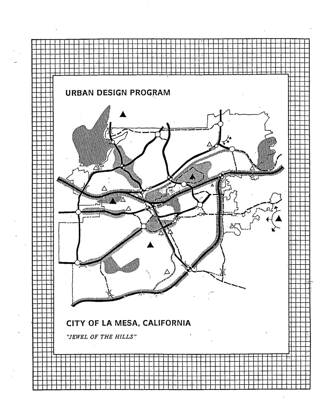
210
211
212
213
214
215
216
217
218

219
220
221
222
223
224
225
226
227
228

229
230
231
232
233
234
235
236
237
238
239
240
241
242
243
244
245
246
247
248
249
250
251
252
253
254

255
256
257
258
259
260
261
262
263
264
265
266
267
268
269
270
271
272
273
274
275
276
277
278
279
280
281
282
283
284
285
286
287
288
289
290
291
292
293
294
295
296
297
298
299
300
301
302
303
304
305
306
307
308
309
310
311


312 DESIGN GUIDELINES FOR PROPERTIES IN THE MIXED-USE OVERLAY ZONE Projects located in the Mixed-Use Overlay Zone (MU) are subject to Urban Design Review by the City s Design Review Board. The City s Urban Design Program report describes the City s Design Review Process and provides design guidelines. The following design guidelines include three sections. Section I of this document is the vision. Section II includes the design guidelines to be utilized by the City s Design Review Board in addition to the guidelines in the current Urban Design Program. Section III includes conceptual plans and massing studies for several specific sites. If a guideline is already part of the Urban Design Program, it is not repeated here. SECTION I - OVERALL VISION The City of La Mesa General Plan designates three older commercial corridors, El Cajon Boulevard, University Avenue, and La Mesa Boulevard, as Mixed-Use Urban. In order to implement this General Plan designation, and to prepare zoning development standards and guidelines for the properties designated as Mixed-Use Urban, a vision for the corridors must be defined first. Mixed Use means a mixture of both commercial and residential, combined to create a vital and attractive environment for residents, employees, and visitors along each corridor. The boulevards are envisioned to be transformed by a mixture of uses including retail, office, residential, open space, and public uses connected to each other and to transit by a walkable environment along the street. Today, El Cajon Boulevard, University Avenue, and La Mesa Boulevard are wide streets giving the adjacent private development an auto-oriented character. The City has undergrounded the utilities and added landscaped medians to corridors making the streets more attractive. However, to create places for people to live, work and stroll along the boulevards, the overall environment will need to change at the edges of the street adjacent to private properties. These street edges, the pedestrian realm, will need to become walkable and lively places with more

313 street trees, wider sidewalk, fewer curb cuts, special bus shelters, street furniture, decorative pedestrian crossings, public gathering spaces, and visual interest at the ground floor of buildings. Changing the character of the boulevard with new uses, a new pedestrian realm along the street and pedestrian improvements along the cross streets will enhance the quality of life in the neighborhoods adjoining the corridors. Mixed use may be horizontal mixed use or vertical mixed use. Horizontal mixed use means that residential and commercial uses are adjacent to each other. Vertical mixed use means that residential and commercial uses are stacked over each other. Typically, residential uses are placed over ground-floor retail, office and/or restaurant uses. Not all projects along the corridor must be mixed use to achieve the goals of the plan. For example, a new residential-only project sensitively designed and located adjacent to an older existing commercial building may help to stimulate renovation and reuse. The commercial building could be adaptively reused as a restaurant with outdoor seating serving the new residents as well as existing nearby residents. Successful infill development keeps a sense of history of each boulevard and enriches the life of the community. Design Guidelines For Properties Located in the Mixed-Use Overlay Zone City Of La Mesa Community Development Department October 2003 Page 2


314 The following are features of the overall vision for the corridors: Attractive, walkable environments along the streets include: - Wider sidewalks with landscaping, street furniture and other amenities. - Buildings instead of parking lots along the street - Visual interest incorporated at the ground level including frequent windows, awnings, indentations, outdoor dining, etc. New uses that enhance the walkable environment such as: - Infill residential and new retail spaces that are less auto dependent - Limitations on uses that are incompatible with residential Two- to four-story townhouses / condominiums / apartments designed to be pedestrian friendly and compatible with adjacent neighborhoods Design considerations of privacy, noise, light, and traffic intrusion when adjacent to existing neighborhoods Incentives for consolidating parcels Flexibility in requirements to respond to varied site conditions Places for transit stops designed as part of new development High-quality design with appropriate detail and articulation Where appropriate, create a sense of history along each corridor by incorporating existing buildings and uses in a project. Design Guidelines For Properties Located in the Mixed-Use Overlay Zone City Of La Mesa Community Development Department October 2003 Page 3

315 SECTION II - DESIGN GUIDELINES The following are design guidelines to be utilized by the City s Design Review Board in addition to the guidelines in the Urban Design Program. A. Pedestrian Orientation Along Street Frontage / Setbacks The pedestrian realm should include the following: inch box street trees should be planted approximately 30 to 35 feet apart in a 5-foot street furnishing area adjacent to the curb in the public right-of-way, if underground utilities permit. If the City s Department of Public Works determines that below grade utilities limit street trees at the curb, trees in planters with irrigation should be located at the curb or additional width may be added to the pedestrian realm to allow street trees to be planted between the sidewalk area and the adjacent building. 2. Street trees along El Cajon Boulevard, University Avenue and La Mesa Boulevard should be planted in tree wells with metal or concrete grates or that are landscaped, as approved by the City. 3. Street trees and ground cover may be planted in the 5-foot wide landscaped parkway adjacent to the curb along La Mesa Boulevard. 4. A concrete sidewalk should be provided with a clear pedestrian passage at least 5 feet wide, free of encroachment by landscape features, street furniture, or similar obstructions. 5. Appropriate pedestrian amenities should be provided such as outdoor seating, bus waiting areas, trash receptacles, public art, and plants in pots. 6. Plant materials specified for the pedestrian realm and the public open space areas are subject to City approval. Design Guidelines For Properties Located in the Mixed-Use Overlay Zone City Of La Mesa Community Development Department October 2003 Page 4


316 7. Residential on the ground-floor fronting the pedestrian realm should be located a minimum of 2 feet and a maximum of 3 feet above the sidewalk level or provide some other similar solution to provide privacy. 8. At least 50 percent of the ground floor façade of a commercial building should be devoted to transparent windows and/or doors. 9. For projects located at intersections, the design treatment provided for the pedestrian realm should be continued around the corner and an appropriate transition to between the project improvements and the adjacent public and private improvements should be provided. B. Ground-Floor Use and Design 1. Although ground-floor retail, restaurant and other pedestrian-friendly neighborhood serving uses are preferable along the pedestrian realm, residential is permitted on the ground floor with the following guidelines: a. Residential located on the ground floor facing the pedestrian realm should be designed with articulated facades, including features such as awnings, elevated steps and entrances, recessed windows, doors and patios, windows treated for privacy and pedestrian interest, and drought-tolerant planting. b. The more public areas of the residential units, such as lobbies, exercise rooms, living rooms, or dining areas, should face the street while more private areas, such as bedrooms, should be located in the rear of the building or on upper floors. Design Guidelines For Properties Located in the Mixed-Use Overlay Zone City Of La Mesa Community Development Department October 2003 Page 5

317 2. New development located at signalized intersections of major streets should include pedestrian-oriented community-serving commercial uses. 3. For development on sites over 30,000 square feet, it is encouraged that at least 30 percent of the linear street frontage on a major arterial excluding driveways and pedestrian connections be designed to accommodate pedestrian-oriented neighborhood serving uses including retail, restaurant, office or other community serving uses. The minimum depth of these uses should be 25 feet. C. Building Height 1. Building height should transition from the maximum building height to a lower height when directly adjacent to a single-family residential zone. However, when the adjacent single-family residential zone is at a much higher elevation than the mixed-use development, the building height may not need to transition to a lower height. 2. To accommodate the extra floor-to-floor ceiling heights of commercial uses, new mixed-use development with retail or restaurant uses on the ground floor may exceed the 46-foot building height limit up to 4 feet as long as the building does not exceed 4 stories, upon approval by the Planning Commission of a Special Permit, Section Heights greater than 46 (up to 6 stories) may be considered under Section Special Permits for any mixed-use development that includes Design Guidelines For Properties Located in the Mixed-Use Overlay Zone City Of La Mesa Community Development Department October 2003 Page 6
 is the maximum height limit.")
318 underground parking, more public open space adjacent to the street than is required, and is sensitively designed to be compatible with adjoining properties. 4. Forty-six feet (46 ) is the maximum height limit. However, variations in building height and massing as well as articulated facades contribute to community image, provide human scale and improve the pedestrian experience along the mixed-use corridors. D. Treatment Adjacent Single-Family Residential Zone 1. To provide privacy for adjacent singlefamily, windows in mixed-use projects directly facing single-family zones within 15 feet of the property line, should be designed either as translucent, louvered, offset from existing single-family windows, located at least five feet above the floor of each level or another solution achieving this intent. 2. Mixed-use projects should be designed to minimize motor vehicle circulation through local single-family neighborhood streets. 3. Guest parking areas should be located and designed to be convenient in order to minimize parking in residential neighborhoods. 4. Façades and garages that face existing single-family should be designed to be comparable with the setbacks and scale of the existing development. Design Guidelines For Properties Located in the Mixed-Use Overlay Zone City Of La Mesa Community Development Department October 2003 Page 7


319 E. Access 1. To minimize the number of curb cuts thereby making the streetscape more walkable and attractive for new mixed-use projects, consolidation of building sites should be encouraged to reduce the number of access drives from the major arterials. Shared driveway access between lots is permitted to further reduce driveways cuts from the arterials. 2. Vehicular access should be provided from the side streets, adjacent alleys, and parallel streets, if available and traffic calming techniques should be provided to minimize intrusion of traffic into adjacent neighborhoods. Where side streets, alleys, or parallel streets are not available, driveways access should be limited to no more than one 20-foot wide driveway per 200 feet of building frontage. 3. Improvements in the public right-of-way and pedestrian realm should be consistent with City plans for streetscape improvements such as median landscaping. Pedestrian crossings at arterials should include items such as curb extensions at intersections, decorative crosswalk paving, shortened turning radii for cars, complementary plant materials, pedestrian lighting and bus shelters. For details, refer to the Master Plan for University Avenue and Design Guidelines and Recommendations for the Revitalization of El Cajon Boulevard. Design Guidelines For Properties Located in the Mixed-Use Overlay Zone City Of La Mesa Community Development Department October 2003 Page 8


320 F. Parking 1. Parking should be conveniently located near non-residential uses but visibly minimized from arterial streets and public spaces. 2. Centralized parking decks/courts within the mixed-use development or below-grade parking should be provided for projects that include over 30 dwelling units per acre. 3. Parking access may be taken directly from an alley. G. Open Space 1. Common recreational areas should be centrally located and preferably be designed as courtyards or outdoor rooms. Outdoor recreational furnishings, community amenities, public gathering places, trees, shrubs and trellises for shade should be provided, where appropriate. Design Guidelines For Properties Located in the Mixed-Use Overlay Zone City Of La Mesa Community Development Department October 2003 Page 9


321 2. On sites over 30,000 square feet, a usable open space or public gathering place accessible to the community such as a pocket park or an expanded waiting area adjacent to a bus stop may be provided. H. Architectural Character and Massing 1. The form of mixed-use and residential use only buildings and architectural details should be designed to create visual interest at the street level using techniques such as staggering the frontage of the building, recessing doors and windows, providing varied display windows, providing awnings and canopies for weather protection and scale, and visually extending interior spaces outside through paving and glazing. 2. Building plans and facades should vary from building to building and from project to project to create interest along the street. Design Guidelines For Properties Located in the Mixed-Use Overlay Zone City Of La Mesa Community Development Department October 2003 Page 10


322 3. Materials and colors should be selected to unify the building appearance and fit into the pedestrian realm context. 4. Security features and equipment should be permitted if completely concealed and mounted inside of the structure. I. Compatibility with Surrounding Development and Between Uses on the Site 1. The design of the structures should address privacy between residential units and other non-residential uses on the site and on adjacent properties. 2. The design of the structures should compliment the street pedestrian realm with plazas, pocket parks, public gathering spaces, street furniture and landscaping. 3. The design should provide visual and physical cues that demark the public space from the private space. Design Guidelines For Properties Located in the Mixed-Use Overlay Zone City Of La Mesa Community Development Department October 2003 Page 11

323


324 K. Consolidations 1. As many of the lots are smaller than 10,000 square feet, lot consolidation is encouraged along the corridors to leave more space along the pedestrian realm for streets trees, other pedestrian amenities and on-street parking, as well as providing more efficient private development sites. 2. When consolidating lots, new development should respect the existing fabric of the community by reflecting historic development patterns through the use of building indentations, breaks in buildings for open space, changes in color, or other methods. Design Guidelines For Properties Located in the Mixed-Use Overlay Zone City Of La Mesa Community Development Department October 2003 Page 13

325
LANDSCAPE STANDARDS PURPOSE AND INTENT OF LANDSCAPE ORDINANCE
 LANDSCAPE STANDARDS COMMUNITY DEVELOPMENT DEPARTMENT / PLANNING DIVISION 8130 Allison Avenue, La Mesa, CA 91942 Phone: 619.667-1177 Fax: 619.667-1380 PURPOSE AND INTENT OF LANDSCAPE ORDINANCE The regulations
Landscape and fencing requirements of this Chapter shall apply to all new landscaped areas.
 Chapter 19.06. Landscaping and Fencing. Sections: 19.06.01. Purpose. 19.06.02. Required Landscaping Improvements. 19.06.03. General Provisions. 19.06.04. Landscaping Plan. 19.06.05. Completion of Landscape
CITY OF GILROY CONSOLIDATED LANDSCAPING POLICY
 CITY OF GILROY CONSOLIDATED LANDSCAPING POLICY Adopted by the City Council January 19, 1988 And amended September 17, 1990, October 18, 1999 THE PURPOSE OF THIS LANDSCAPING POLICY IS TO PROVIDE A COMPREHENSIVE
BUFFERS, TREE PROTECTION AND LANDSCAPING. Sec Purpose and Intent.
 ARTICLE 20 BUFFERS, TREE PROTECTION AND LANDSCAPING Sec. 20.1. Purpose and Intent. Trees improve air and water quality, reduce soil erosion, reduce noise and glare, provide habitat for desirable wildlife,
Improve the appearance of off-street parking areas, vehicular use areas, and property abutting public and private roads;
 Bedford Township, MI (Monroe Co.) 2012 http://library.municode.com/index.aspx?clientid=02123 400.1907 - Landscaping and screening. Se 1907. 1. Intent. Landscaping, greenbelts, and screening are necessary
ARTICLE 9: LANDSCAPING AND FENCING REQUIREMENTS
 ARTICLE 9: LANDSCAPING AND FENCING REQUIREMENTS Section 9.01 Intent The intent of the landscaping requirements are to improve the appearance of lot areas and soften paved areas and buildings; to provide
5.1.1 The streetscape along US Highway 64 (Brevard Road); and, The built environment within new residential developments; and,
; and, The built environment within new residential developments; and,") Article 5. Landscaping 5.1 Purpose The Town of Laurel Park s landscape standards are designed to create a beautiful, aesthetically pleasing built environment that will complement and enhance community
Article 5. Landscaping 5.1 Purpose The Town of Laurel Park s landscape standards are designed to create a beautiful, aesthetically pleasing built environment that will complement and enhance community
Landscaping Standards
 CHAPTER 29 ARTICLE 403 29.403 Landscaping Standards Purpose: The purpose of this section is to protect and promote the public health, safety and general welfare by requiring landscaping in relation to
The purpose of the requirements in this Article is to provide for landscaping and screening of parking and other outdoor areas that will:
 XIII. LANDSCAPING & SCREENING A. Purpose The purpose of the requirements in this Article is to provide for landscaping and screening of parking and other outdoor areas that will: 1. Protect residential
For the purposes of this chapter, the words and terms used herein are defined as follows:
 City of Visalia Street Tree Ordinance 12.20.010 Purpose. The purpose of this chapter is to promote and regulate the planting, long term care, maintenance, and protection of street trees within the city.
CHAPTER 26 LANDSCAPING (Chapter added in its entirety 05-08)
") CHAPTER 26 LANDSCAPING (Chapter added in its entirety 05-08) 26.01 DESCRIPTION AND PURPOSE. Landscaping is an important element of the use, development and preservation of land, and a significant factor
CHAPTER 26 LANDSCAPING (Chapter added in its entirety 05-08) 26.01 DESCRIPTION AND PURPOSE. Landscaping is an important element of the use, development and preservation of land, and a significant factor
City of Sheridan Landscape Plan Checklist
 Included? Section 1. Exemptions - Landscape Plan not Applicable (Sec. 56-512) 1. Single family dwellings, attached and detached, are exempt from landscape regulations and from providing landscape plans.
LANDSCAPE ORDINANCE 1. LANDSCAPE PLAN REVIEW REQUIREMENTS
 LANDSCAPE ORDINANCE PURPOSE A. The purpose of this chapter is to protect and promote the public health, safety, general welfare and beautification through the City of Kalispell s authority to regulate
D. Landscape Design. 1. Coverage Intent: To provide adequate landscaping materials that enhance the appearance of development projects.
 D. Landscape Design The standards and guidelines in this section give design guidance for the landscaping components of industrial and office projects. City regulations require that all landscaping be
GENERAL LANDSCAPE PROVISIONS. The following landscape provisions shall be adhered to by all land uses unless otherwise noted:
 CHAPTER 1.18 Sections: 1.18.005 Purpose. 1.18.010 Landscaping, Buffering, and Fencing Improvements Required. 1.18.015 General Landscape Provisions. 1.18.020 Landscaping Plan. 1.18.025 Single-Family Dwellings
The following specific definitions shall apply to the landscaping and screening regulations contained in this article:
 ARTICLE XII. LANDSCAPING Sec. 5-421. Purpose. The purpose of landscaping and screening requirements is to improve certain setback and yard areas, including off-street vehicular parking and open-lot sales
V-5 TREE PROTECTION AND LANDSCAPING REQUIREMENTS
 V-5 TREE PROTECTION AND LANDSCAPING REQUIREMENTS V-5.1 General A. Intent: It is the intent of this section to establish protective regulations for trees within the City of Milton, in order to better control
LANDSCAPE ORDINANCE PASADENA PLANNING DEPARTMENT (713) FAX (713)
 FAX (713)") LANDSCAPE ORDINANCE PASADENA PLANNING DEPARTMENT (713) 475-5543 FAX (713) 477-1072 ARTICLE X. LANDSCAPING OF NONRESIDENTIAL SITES* Sec. 9-195. Applicability. (a) This article shall apply to the following:
LANDSCAPE ORDINANCE PASADENA PLANNING DEPARTMENT (713) 475-5543 FAX (713) 477-1072 ARTICLE X. LANDSCAPING OF NONRESIDENTIAL SITES* Sec. 9-195. Applicability. (a) This article shall apply to the following:
ARTICLE 5 LANDSCAPE IMPROVEMENTS
 ARTICLE 5 LANDSCAPE IMPROVEMENTS 5-1 Purpose and Applicability 5-2 Landscape Plans and Installation 5-3 Landscaping Standards 5-4 Landscape Maintenance ARTICLE 5-1 PURPOSE AND APPLICABILITY 5-1-1 Purpose
Bylaw A Bylaw to amend Bylaw 12800, as amended, The Edmonton Zoning Bylaw Amendment No. 2239
 Bylaw 17672 A Bylaw to amend Bylaw 12800, as amended, The Edmonton Zoning Bylaw Amendment No. 2239 WHEREAS City Council at its meeting of February 22, 2001, gave third reading to Bylaw 12800, as amended;
CARVER COUNTY DIVISION OF PUBLIC WORKS LANDSCAPE POLICY. Adopted by the Carver County Board of Commissioners March 3, 2015
 CARVER COUNTY DIVISION OF PUBLIC WORKS LANDSCAPE POLICY Adopted by the Carver County Board of Commissioners March 3, 2015 Policy Statement Goals It is the goal of Carver County Public Works to provide
ARTICLE XIX SCREENING, LANDSCAPING AND TREES
 ARTICLE XIX SCREENING, LANDSCAPING AND TREES Part I. Landscaping and Screening Section 304 Purpose. The purpose of this Part is to establish minimum landscaping and screening requirements that provide
3.13. Development Guidelines
 3.3 Landscaping Elements Landscaping should be used to frame and soften structures, define site functions, enhance the quality of the environment, and screen undesirable views. Safety, environmental impacts,
Landscaping Regulations for City of Billings & Yellowstone County Jurisdictional Area
 Landscaping Regulations for City of Billings & Yellowstone County Jurisdictional Area Sec. 27-1101. Purpose. The purpose of this section is to provide landscaping and performance standards which: A. Enhance
Landscape area requirement compliance and landscape plans
 ARTICLE 6 LANDSCAPING 6-1. Statement of Intent The purpose of this Article is to promote the public health, safety and welfare by providing for the preservation, installation and maintenance of trees and
E. Natural areas include habitats such as wetlands, tidal marshes, waterways, natural drainage-ways, woodlands and grassland meadows.
 Adopted November 1999 I. Purpose A. The purpose of these guidelines is to assist in the design and layout of open space, as provided on developed lots within the District. The intent of these guidelines
LANDSCAPE AND IRRIGATION PLAN PREPARATION GUIDELINES
 LANDSCAPE AND IRRIGATION PLAN PREPARATION GUIDELINES The Parks Planning and Development Division of the City of Modesto s Parks, Recreation and Neighborhoods Department is responsible for the task of reviewing
The planning and zoning board considered amending the zoning code to address plantings and alteration of the swale.
 MIAMI SHORES DEPARTMENT OF PLANNING & ZONING 10050 NE 2 nd Avenue Miami Shores FL 33037-2304 www.miamishoresvillage.com David A. Dacquisto AICP, Director Main Number: 305-795-2207 Fax Number: 305-756-8972
Design Guidelines for Residential Subdivisions
 Design Guidelines for Residential Subdivisions Development Services 972-466-3225 cityofcarrollton.com This page intentionally left blank. Table of Contents Purpose... 1 Design Objectives... 1 Design Guidelines
4.500 Preston Road Overlay District
 Section 4.500 Preston Road Overlay District 2004 Zoning Ordinance 4.500 Preston Road Overlay District (ZC 98-29; Ordinance No. 98-9-12) 4.501 Purpose To provide appropriate design standards for the use
Article 10: Landscaping and Buffering
 10.01: Purpose Article 10: Landscaping 10.01: Purpose The purpose of this article is to: A) Promote and protect the interest of the public convenience, comfort, prosperity, or general welfare in accordance
ARTICLE 9: Landscaping
 ARTICLE 9: Landscaping 9-10 Legislative Intent The purpose of this Article is to regulate the planting and preservation of landscape materials; to facilitate the creation of an attractive and healthy environment;
DESIGN AND LANDSCAPE GUIDELINES FOR DEVELOPMENT
 DESIGN AND LANDSCAPE GUIDELINES FOR DEVELOPMENT IN THE SECOND SUPERVISORIAL DISTRICT (REVISED) ADOPTED BY RIVERSIDE COUNTY BOARD OF SUPERVISORS ON SEPTEMBER 15, 1998 REVISED OCTOBER 23, 1998 REVISED AUGUST
City of Kelowna Consolidated Zoning Bylaw No. 8000
 Section 7 Landscaping and Screening 7.1 Required Landscaping 7.1.1 The minimum level of landscaping required in each zone along all front, rear and side yards shall be determined from the Minimum Landscape
Chapter 19.5 LANDSCAPING REQUIREMENTS
 Chapter 19.5 LANDSCAPING REQUIREMENTS Sec. 19.5-1. Intent The intent of the landscaping requirements stated herein are as follows: To aid in stabilizing the environment's ecological balance by contribution
NC State University Design and Construction Guidelines Division 32 Exterior Improvements Plants, Turf Grass, and Soil Preparation
 1.0 Purpose These guidelines are for the use of all Campus landscaping. 2.0 General Requirements 1. Native trees and shrubs appropriate for this region are strongly preferred. The university has a do not
VEHICULAR AND PEDESTRIAN CIRCULATION
 This perspective sketch communicates the intended character and quality of a proposed streetscape design. Locate benches near a major intersection where people tend to gather. Seating and lighting provide
LANDSCAPE GUIDELINES. Submitted by the Landscape Committee of The Village Townhomeowners Association
 LANDSCAPE GUIDELINES Submitted by the Landscape Committee of The Village Townhomeowners Association Approved by the THOA Board of Directors April 2015 THE VILLAGE TOWNHOMEOWNERS ASSOCIATION BRADFORD WOODS,
SECTION RESIDENTIAL LANDSCAPING, STREETSCAPING, AND AMENITY STANDARDS
 SECTION 3.5400 RESIDENTIAL LANDSCAPING, STREETSCAPING, AND AMENITY STANDARDS 3.5401 RESIDENTIAL LANDSCAPE STANDARDS a) These standards shall apply to any single family detached and duplex residential zoning
SITE PLAN REVIEW APPLICATION AND CHECKLIST
 SITE PLAN REVIEW APPLICATION AND CHECKLIST PROJECT SUMMARY: Project Name: City/ETA Location: City ETA (Application fee & number of copies needed are based on location) Property Location (Legal Description
Community Design Plan
 Gardena General Plan 2006 Authority While the is not a required element of a General Plan, it is included because improving the community appearance and image is paramount to the overall quality of life
EXHIBIT A COOKE'S HOPE HOMEOWNERS ASSOCIATION FRONT YARD EASEMENT AREA MINIMUM STANDARDS FOR GARDEN MAINTENANCE
 EXHIBIT A COOKE'S HOPE HOMEOWNERS ASSOCIATION FRONT YARD EASEMENT AREA MINIMUM STANDARDS FOR GARDEN MAINTENANCE I. Definitions. For the purposes of these Cooke's Hope Homeowner's Association ("HOA") Minimum
Construction and Landscaping on Public Property
 Construction and Landscaping on Public Property City of Manhattan Beach Community Development Department 1400 Highland Avenue 310-802-5504 www.citymb.info January, 2004 Construction and Landscaping on
LANDSCAPING, BUFFERING
 A. Fencing 1. Unless otherwise provided in this Bylaw, the following shall apply to all Urban zones: a. No fence shall be constructed on a Lot to a Height exceeding: i. 1.9m (6.2 ft), or ii. 1.2m (3.9
Town of Fuquay-Varina
 170 LANDSCAPING 170.01 GENERAL 170.01.01 Street trees shall be provided in accordance with the Land Development Ordinance for site plans and subdivisions 170.01.02 Street trees, landscape areas, landscape
Required Internal Landscaping Percentage of Ground Cover in Living Materials Percentage of Tree Size
 CHAPTER 12-24 LANDSCAPE STANDARDS 12-24-101 Purpose 12-24-102 Landscaping Required 12-24-103 Parking Lot Screening 12-24-104 Parking Lot Trees 12-24-105 12-24-106 Landscaped Setbacks Buffers 12-24-107
SECTION LANDSCAPE MAINTENANCE FOR 90 DAYS. A. Section includes requirements for 90 day landscape maintenance for the following:
 SECTION 320190.13 LANDSCAPE MAINTENANCE FOR 90 DAYS PART 1 - GENERAL 1.1 SUMMARY A. Section includes requirements for 90 day landscape maintenance for the following: 1. Watering trees and grass. 2. Monitoring
Exhibit A. Scope of Work
 Exhibit A Scope of Work TURF / LAWNS Mowing Lawns shall be mowed weekly during growing season and as required during winter months. The height of mowing shall be maintained consistently to prevent scalping
COMMUNITY DESIGN. GOAL: Create livable and attractive communities. Intent
 COMMUNITY DESIGN Intent An attractive, well-designed County will attract quality development, instill civic pride, improve the visual character of the community, and create a strong, positive image for
ZONING ORDINANCE FOR THE ZONED UNINCORPORATED AREAS ARTICLE 1300 OF PUTNAM COUNTY, WEST VIRGINIA Page 119 ARTICLE 1300 LANDSCAPING AND SCREENING
 OF PUTNAM COUNTY, WEST VIRGINIA Page 119 ARTICLE 1300 LSCAPING SCREENING 1300.01 STATEMENT OF LEGISLATIVE INTENT 1300.02 GENERAL PROVISIONS 1300.03 REQUIREMENTS 1300.04 SUBMISSION APPROVAL 1300.05 SCREENING
City of Highland Park, MI Tree Ordinance
 City of Highland Park, MI Tree Ordinance http://library1.municode.com/minutes/home.htm?infobase=50019&doc_action=whatsnew CHAPTER 1026 Trees, Plants and Shrubs 1026.01 Definitions. 1026.02 Inspections.
ARTICLE II. LANDSCAPING
 ARTICLE II. LANDSCAPING Sec. 35-31. Landscaping required for all site development. (a) Residential Developments: (1) All residential lots shall provide a minimum of one (1) boulevard tree (planted between
CHAPTER 4: GENERAL LANDSCAPING STANDARDS 4.1 ALL PLANT STOCK 4.2 TREES
 CHAPTER 4: GENERAL LANDSCAPING STANDARDS This chapter describes plant material minimum standards that apply to landscaping both on private property (on-site) and within the public right-of-way (off-site).
Chapter LANDSCAPE FOR PLANNING APPLICATIONS
 Chapter 27.71 LANDSCAPE FOR PLANNING APPLICATIONS 27.71.010 PURPOSE. The purpose of this chapter is to enhance the quality of life in San Mateo by the provision for appropriate design of landscaping and
2-B-18-UR. Revised: 3/27/2018
 Revised: 3/27/2018 Revised: 3/27/2018 GI FOR KIDS A MEDICAL OFFICE BLDG. 0000 BOARDWALK BLVD. KNOXVILLE, TENNESSEE CONSTRUCTION PRELIMINARY - NOT FOR Landscape Plan Target Publix Town Center Boulevard
PRELIMINARY PLAT DESIGN REQUIREMENTS Updated 4/8/2016
 PRELIMINARY PLAT DESIGN REQUIREMENTS Updated 4/8/2016 The following items are required for the preliminary plat. Numbers correspond with those on the example preliminary plat. RENO COUNTY SUBDIVISION REQUIREMENTS
LANDSCAPING. Design. Development of the site shall not unreasonably impair the ability of adjoining properties to utilize solar energy.
 Landscape design is an integral component of Site Planning and Building. The current pattern of walkways, driveways and landscape elements such as fences, hedges, and retaining walls in the neighborhood
8 ARTICLE EIGHT LANDSCAPING AND SCREENING
 8 ARTICLE EIGHT LANDSCAPING AND SCREENING STANDARDS 801 Purpose The Landscaping and Screening Regulations provide additional guidance on the development of sites within Storm Lake by addressing landscaping
Ephrata Municipal Code, Chapter 19.07, Landscaping Regulations DRAFT January 28, 2013 Page 1
 Chapter 19.07 LANDSCAPING REGULATIONS Sections: 19.07.010 Purpose. 19.07.020 Landscape plan approval. 19.07.030 Failure to complete required landscaping Inspection. 19.07.040 General landscape requirements
ARTICLE 10 LANDSCAPING
 TABLE OF CONTENTS Page 10.1 Purpose and Findings... 10-2 10.2 Applicability... 10-3 10.2.1 Permits... 10-3 10.2.2 Types of Development... 10-3 10.2.3 Exempt Development... 10-4 10.2.4 Expansion of Uses...
PART TWO: PROJECT SPECIFIC DESIGN GUIDELINES
 PART TWO: PROJECT SPECIFIC DESIGN GUIDELINES 2.1.0 GENERAL REQUIREMENTS: 1. Approved warm season turf varieties shall be used for LMD/CFD, commercial, industrial, and public landscape areas. The use of
ORDINANCE NO AN ORDINANCE AMENDING THE CODE OF ORDINANCES OF THE CITY OF
 ORDINANCE NO. 07-03- 15-08 AN ORDINANCE AMENDING THE CODE OF ORDINANCES OF THE CITY OF CORINTH, BY ADDING A CHAPTER 158 " XERISCAPE PRACTICE AND PRINCIPALS "; PROVIDING THAT THIS ORDINANCE SHALL BE CUMULATIVE
Chapter Landscaping and Screening
 Chapter 17-11 Landscaping and Screening 17-11-0050 Guide to the Chicago Landscape Ordinance...11-1 17-11-0100 Parkway Trees...11-1 17-11-0200 Vehicular Use Areas...11-2 17-11-0300 Trash Storage Area Screening...11-9
 Celebration Residential Owners Association, Inc. Celebration Non-Residential Owners Association, Inc. 851 Celebration Avenue, Celebration, Florida 34747 Phone 407-566-1200 Fax 407-566-1210 ARC@celebrationtownhall.com
City of Aurora Planning Department DESIGN STANDARDS FOR MOTOR VEHICLE FUEL DISPENSING STATION. August 3, 1998
 City of Aurora Planning Department DESIGN STANDARDS FOR MOTOR VEHICLE FUEL DISPENSING STATION August 3, 1998 1. GENERAL PURPOSE AND APPLICABILITY The following design standards for motor vehicle fuel dispensing
TOWNSHIP OF LOGAN SOIL & FILL IMPORTATION AND PLACEMENT APPLICATION SUBMITTAL CHECKLIST
 TOWNSHIP OF LOGAN SOIL & FILL IMPORTATION AND PLACEMENT APPLICATION SUBMITTAL CHECKLIST Applications: 5 copies of application - Applicant will reproduce the copies at his/her costs. The Township Clerk
ARTICLE XII BUFFER REQUIREMENTS
 ARTICLE XII 1200. Intent. It is the intent of this section to establish standards to provide for buffer amenities and screening throughout unincorporated Georgetown County. The purpose of these standards
ARTICLE 17 SITE PLAN REVIEW
 ARTICLE 17 SITE PLAN REVIEW 17.01 INTENT AND PURPOSE The intent of this section is to provide for consultation and cooperation between the applicant and the township planning commission so that the applicant
A BILL FOR AN ORDINANCE TO AMEND CHAPTER 9, KAUAI COUNTY CODE 1987, RELATING TO STREET REQUIRE:MENTS FOR SUBDIVISIONS
 ORDINANCE NO. BILL NO. { vy"yj1j A BILL FOR AN ORDINANCE TO AMEND CHAPTER 9, KAUAI COUNTY CODE 1987, RELATING TO STREET REQUIRE:MENTS FOR SUBDIVISIONS BE IT ORDAINED BY THE COUNCIL OF THE COUNTY OF KAUA'I,
5.1 Commercial and Industrial Development. (Effective April 1, 2006)
") 5.1 Commercial and Industrial Development. (Effective April 1, 2006) A. Applicability: The requirements of this section (5.10) shall apply to all uses within the LB Local Business; HB Highway Business;
5.1 Commercial and Industrial Development. (Effective April 1, 2006) A. Applicability: The requirements of this section (5.10) shall apply to all uses within the LB Local Business; HB Highway Business;
ORDINANCE Underline: Additions to Ordinance Strike-through: Deleted Text from Existing Ordinance
 AN ORDINANCE OF INDIAN RIVER COUNTY, FLORIDA CONCERNING AMENDMENTS TO LAND DEVELOPMENT REGULATIONS (LDRS); PROVIDING FINDINGS; PROVIDING FOR AMENDMENTS TO CHAPTER, 901, DEFINITIONS; CHAPTER 911, ZONING;
COMMUNITY DEVELOPMENT DEPARTMENT
 COMMUNITY DEVELOPMENT DEPARTMENT CONDITIONAL USE APPLICATION FOR CITY USE ONLY Date Received: Date Determined Complete: Fees Paid: PC Meeting: Fees: $200 / $400 with Site Plan; plus all applicable Engineering
WASHINGTON TERRACE CITY ORDINANCE LANDSCAPING AMENDED
 WASHINGTON TERRACE CITY ORDINANCE 2018-09 LANDSCAPING AMENDED AN ORDINANCE OF THE CITY OF WASHINGTON TERRACE, UTAH, AMENDING CHAPTER 17.44 RELATED TO LANDSCAPING MAKING TECHNICAL CHANGES; SEVERABILITY;
CHAPTER BEAUTIFICATION AND LANDSCAPE MANAGEMENT
 APPLICATIONS FOR BEAUTIFICATION GRANTS (STARTING FISCAL YEAR 2017-2018) MUST ADHERE TO THE REQUIREMENTS OF RULE CHAPTER 14-40, FLORIDA ADMISTRATIVE CODE Including the pending revisions shown below CHAPTER
NOW, THEREFORE, THE CITY COUNCIL OF THE CITY OF SIMI VALLEY DOES ORDAIN AS FOLLOWS:
 ORDINANCE NO. 1241 AN ORDINANCE OF THE CITY COUNCIL OF THE CITY OF SIMI VALLEY APPROVING A SIMI VALLEY MUNICIPAL CODE TEXT AMENDMENT (Z-S-721) TO ALLOW THE USE OF ARTIFICIAL TURF IN MULTI-FAMILY RESIDENTIAL
Parks & Recreation Tree Board - Tree Ordinance Angola, Indiana
 Parks & Recreation Tree Board - Tree Ordinance Angola, Indiana 97.01 PURPOSE. (A) Promote and enhance the beauty of the city through tree preservation and landscaping. (B) Safeguard the ecological environment
This article shall be known and may be referred to as the "Landscaping Ordinance of the City of Baytown" or simply as the "Landscaping Ordinance.
 ARTICLE XIV. LANDSCAPING* *Note: See the editor's note to ch. 18. Sec. 18-1201. General regulations. (a) Title. This article shall be known and may be referred to as the "Landscaping Ordinance of the City
ARLINGTON COUNTY, VIRGINIA
 ARLINGTON COUNTY, VIRGINIA County Board Agenda Item Meeting of January 27, 2007 DATE: January 12, 2007 SUBJECT: U-3101-04-2 Use Permit Review for drive-through facilities; premises known as 5222 Lee Highway
COMMERCIAL & INDUSTRIAL DESIGN GUIDELINES CITY OF RANCHO CUCAMONGA PLANNING DIVISION
 COMMERCIAL & INDUSTRIAL DESIGN GUIDELINES CITY OF RANCHO CUCAMONGA PLANNING DIVISION INTRODUCTION These guidelines were prepared in response to the needs of many users: developers, property owners, architects,
II. SINGLE FAMILY RESIDENTIAL
 II. SINGLE FAMILY RESIDENTIAL Castle Rock is made up of numerous individually built houses and subdivision tracts that have been developed during the past century. Some of the tracts are diverse in architectural
COUNCIL POLICY. 1. Removals. a) Dead or Hazardous Trees
 Dead or Hazardous Trees") COUNCIL POLICY SUBJECT: BOULEVARD TREE POLICY DATE: MARCH 14, 1988 REFERENCE: 88/CW Revised: June 27/88, Jan. 2/90, Jan. 27/92, Jan. 4/93, March 15/93, Jan. 17/94 1. Removals a) Dead or Hazardous Trees
COUNCIL POLICY SUBJECT: BOULEVARD TREE POLICY DATE: MARCH 14, 1988 REFERENCE: 88/CW Revised: June 27/88, Jan. 2/90, Jan. 27/92, Jan. 4/93, March 15/93, Jan. 17/94 1. Removals a) Dead or Hazardous Trees
PART I-D BUFFERS AND LANDSCAPING REQUIREMENTS
 District Regulations Of General Applicability ARTICLE IX PART I-D BUFFERS AND LANDSCAPING REQUIREMENTS 9-107 BUFFERS AND LANDSCAPING 9-107 A. General Landscaping and Maintenance Requirements. Except for
SUBMITTAL REQUIREMENTS: FINAL PLAN REVIEW- PROJECT DEVELOPMENT PLAN (PDP)
") 1) Application form and filing fee. Application Form.pdf Development Review Guide STEP 6 of 8 SUBMITTAL REQUIREMENTS: FINAL PLAN REVIEW- PROJECT DEVELOPMENT PLAN (PDP) 2) Transportation Development Review
1) Application form and filing fee. Application Form.pdf Development Review Guide STEP 6 of 8 SUBMITTAL REQUIREMENTS: FINAL PLAN REVIEW- PROJECT DEVELOPMENT PLAN (PDP) 2) Transportation Development Review
PLANNING APPROVAL & PLANNED UNIT DEVELOPMENT Date: November 2, 2017
 PLANNING APPROVAL & PLANNED UNIT DEVELOPMENT Date: November 2, 2017 DEVELOPMENT NAME LOCATION Mobile Christian School 5900 Cottage Hill Road (North side of Cottage Hill Road, 230 ± West of Freemont Drive
The planning and zoning board held workshops on January 11, 2016, January 18, 2016 and January 25, 2016 to discuss the issue.
 MIAMI SHORES DEPARTMENT OF PLANNING & ZONING 10050 NE 2 nd Avenue Miami Shores FL 33037-2304 www.miamishoresvillage.com David A. Dacquisto AICP, Director Main Number: 305-795-2207 Fax Number: 305-756-8972
XERISCAPE ARCHITECTURAL LANDSCAPING DESIGN GUIDELINES September 2009
 The purpose of this document is to structure guidelines for other than standard lawn front yard landscape, including xeriscape. 1. XERISCAPE LANDSCAPING Based on current and near term projections of our
CITY OF VISALIA. Parks & Urban Forestry Guidelines. Street Tree Standards For Residential And Commercal Development
 CITY OF VISALIA Parks & Urban Forestry Guidelines Street Tree Standards For Residential And Commercal Development City of Visalia Street Tree Development Standards 2 These guidelines have been established
ESPLANADE LANDSCAPE MAINTENANCE STANDARDS
 ESPLANADE LANDSCAPE MAINTENANCE STANDARDS At Esplanade, landscaping is an essential element of design with the landscape theme being a natural, less formal design focusing on the use of native plant materials.
I. DEFINITIONS For the purpose of this policy the following terms, phrases, words and their derivations shall have the meaning given herein.
 CITY OF DYERSVILLE TREE AND LANDSCAPING ON PUBLIC RIGHT-OF-WAY POLICY This policy shall regulate the planting, maintenance, and removal of trees and shrubs in public rights-of-way. An approval from the
ARTICLE 13 STREETS General
 ARTICLE 13 STREETS 13.1 General Streets shall be designed to suit their functions. Many streets have purposes other than vehicular traffic. As an alternative to current N.C. Department of Transportation
SECTION 1000 HIGHWAY CORRIDOR OVERLAY DISTRICT REGULATIONS
 SECTION 1000 HIGHWAY CORRIDOR OVERLAY DISTRICT REGULATIONS 1001.00 INTENT AND PURPOSE... 1000-1 1002.00 CLASSIFICATIONS... 1000-1 1003.00 DEVELOPMENT STANDARDS TABLES Page 1003.01 Buffer Requirements...................................
F. Driveways. Driveways which provide access to off-street parking or loading from public streets shall comply with the following:
 Section 20.945.040 General Design Standards for Surface Parking Areas. A. Review Authority. Parking lot design and drainage shall be subject to review and approval of the City Transportation Manager. B.
Chapter 11. Industrial Design Guidelines 11.1 INTRODUCTION AND PURPOSE 11.3 SITE PLANNING GUIDELINES 11.2 GENERAL DESIGN OBJECTIVES
 Chapter 11 Industrial Design Guidelines 11.1 INTRODUCTION AND PURPOSE The following industrial/design guidelines seek to assure high quality development in Santa Ana s industrial districts by: The design
Corridor Identity. Section 9. Introduction. Corridor Guiding Principles
 Corridor Identity An attractive and healthy community is a critical element of a quality place, and the design of quality places is a balance between environmental, economic, and social considerations.
ASHLAND RANCH COMMUNITY ASSOCIATION ARCHITECTURAL / LANDSCAPE GUIDELINES
 ASHLAND RANCH COMMUNITY ASSOCIATION ARCHITECTURAL / LANDSCAPE GUIDELINES These Architectural/Landscape Guidelines are in addition to the Declaration and are binding on all Owners and Builders. These Architectural/Landscape
City of Bonner Springs, Kansas
 City of Bonner Springs, Kansas Site Plan Requirements, Outdoor Lighting Standards & Landscape Regulations March 29, 2017 City of Bonner Springs Planning Division SECTION 10. SITE PLANS: ZONING ORDINANCE
C H A P T E R 43. Landscaping, Irrigation and Grading. Sections
 C H A P T E R 43 Landscaping, Irrigation and Grading Sections 25-43.1 Purpose. 25-43.2 General provisions. 25-43.3 Specific provisions. 25-43.4 Landscape Plans and Submittal for Landscape Designs Not Subject
180 ZONING 180. ARTICLE XLII STREETSCAPE ENHANCEMENT OVERLAY ( SEO ) DISTRICT [Added Ord. No. 1086]
![180 ZONING 180. ARTICLE XLII STREETSCAPE ENHANCEMENT OVERLAY ( SEO ) DISTRICT [Added Ord. No. 1086]](/thumbs/75/72360049.jpg "180 ZONING 180. ARTICLE XLII STREETSCAPE ENHANCEMENT OVERLAY ( SEO ) DISTRICT [Added Ord. No. 1086]") 180 ZONING 180 ARTICLE XLII STREETSCAPE ENHANCEMENT OVERLAY ( SEO ) DISTRICT [Added 4-6-2016 Ord. No. 1086] 180.145. SEO DISTRICT 180.145.1. Intent. The SEO DISTRICT Regulations are intended to address
180 ZONING 180 ARTICLE XLII STREETSCAPE ENHANCEMENT OVERLAY ( SEO ) DISTRICT [Added 4-6-2016 Ord. No. 1086] 180.145. SEO DISTRICT 180.145.1. Intent. The SEO DISTRICT Regulations are intended to address
ARTICLE 21A LANDSCAPING AND SCREENING
 ARTICLE 21A LANDSCAPING AND SCREENING SECTION 21A.01 INTENT AND SCOPE OF REQUIREMENTS Landscaping, greenbelts, and screening are necessary for the continued protection and enhancement of all land uses.
B L A C K D I A M O N D D E S I G N G U I D E L I N E S for Multi-family Development
 B L A C K D I A M O N D D E S I G N G U I D E L I N E S for Multi-family Development Adopted June 18, 2009 This section of the Design and focuses on site planning and design guidance for new multi-family