This Review Is Divided Into Two Phases:
|
|
|
- Bruce Boone
- 5 years ago
- Views:
Transcription
1 Semiahmoo Town Centre Review The purpose of this review: To review the Semiahmoo Town Centre Concept Plan, originally approved in 1993, to ensure that this centre will continue to serve the needs of South Surrey residents and remain viable as the residential and commercial heart of the peninsula. Why review this plan? To ensure that the Semiahmoo Town Centre remains competitive in the larger marketplace To accommodate the residential demand for a range of housing types To ensure that the area is attractive, vibrant, and safe This Review Is Divided Into Two Phases: Phase I includes a review of the role, trade area, and function of the Town Centre through a market analysis. It includes an inventory of existing land uses, an overview of the existing utility services and traffic circulation systems, an assessment of development potential in the area, and other issues and opportunities that will influence the further development of the area. Phase II will produce a planning and urban design concept and servicing strategy. It will explore development densities and potential, identify improvements to transportation systems (bicycle, pedestrian, transit, and vehicular), identify parking opportunities, constraints and management strategies, update the servicing strategy, and recommend revisions to the urban design concept. The purpose of this public open house is to present the findings to date from Phase I, and to receive ideas from the Public about the future of Semiahmoo Town Centre
2 Draft Planning Principles Principle 1: Create a complete community and offer, in addition to residential uses, a full range of shopping, financial, medical, and dental offices, health and fitness facilities, restaurants, and entertainment so that a resident can fulfill their daily needs within the Semiahmoo Town Centre. Offices should be encouraged above retail on 152 Street and integrated into the redevelopment of the Semiahmoo Mall as a key strategy for differentiating the Town Centre from nearby malls as a destination with opportunities for fulfilling a number of needs in one place. Fitness is already strong in the Town Centre and supports a health and wellness focus that could be associated with the hospital and with a medical clinic. Restaurants and entertainment are important uses to generate evening activity. Higher densities and a broader range of residential units would support and attract the businesses and amenities that will make Semiahmoo Town Centre more complete. Principle 2: Integrate future development in Semiahmoo with White Rock to be welcoming to all Surrey and White Rock residents. The sense of place that will emerge through the planning process should compliment, but be distinct from the waterfront / Mediterranean character of White Rock. Any changes to transit services should improve the level of service for the area. Principle 3: Design pedestrian-friendly streets that are comfortable and allow easy movement for all people, including seniors and people with wheelchairs, walkers, carts, and strollers. Distances across streets at intersections should be as narrow as possible while retaining vehicular capacity. Sidewalks should be continuous, smooth-surfaced, and have a movement zone that is predictably in the same location throughout the Town Centre. Sidewalks, ramps, and other pedestrian routes should be graded with gentle slopes that are easily negotiated. Adjacent areas should be reviewed to ensure that there are good vehicular and pedestrian circulation connections to the amenities in the Town Centre. Principle 4: Permit additional new residential development to provide a wider range of housing choice than is currently available. Appropriate sites for multiple family housing should be identified along the 152 corridor and on the Semiahmoo Mall redevelopment site, including several sites that could accept a tower form, taking into consideration shadowing, overlook, and compatibility with adjacent development. Other opportunities for residential redevelopment near the edges and transition areas of the Town Centre should be identified. Sites that would be suited to ground-oriented multiple family housing should be identified and front onto streets (other than 152 Street) with a residential character.
3 Draft Planning Principles Continued Principle 5: Include retail, office, and service opportunities for both national chains and local independents, with a mix of shopping centre and street-fronting locations. Semiahmoo Town Centre and Mall both have a significant number of locally owned and operated stores and offices that help to create a uniquely Semiahmoo mix of destinations. New retail, office, and service development should be encouraged to support both national and local operations. Redevelopment of the Semiahmoo Mall should have its movement patterns and storefronts configured to encourage shoppers to access shops and services both within the site and along 152 Street. Reinforcement of a unique character in Semiahmoo through the development of a coordinated urban design concept should be explored. Principle 6: Concentrate retail and office development on 152 Street and within the Semiahmoo Mall site to optimize the market potential for the Town Centre within a walkable distance. Retail businesses should be focused on 152 Street and the mall site to concentrate activity where it is most desired. Martin Drive and 16 Avenue should be considered as having office and residential land uses and an appropriate streetscape character for these uses. Principle 7: Incorporate opportunities for social interaction in the Town Centre, including new public open spaces and indoor community spaces. Indoor space that is open, welcoming, and programmed for the use of seniors, youth and all residents should be available in the Town Centre. A new public plaza could be a focal point near the intersection of 152 Street and 16 Avenue. Public open space with ample seating should be located at intervals in sunny spots along 152 Street for resting and people watching. A well-developed network of public spaces and inviting pedestrian routes are key to making Semiahmoo Town Centre a more attractive destination for regional residents and tourists, and to obtaining economic benefits of becoming a well-recognized place to visit. A recent trend in shopping mall redevelopment following a Main Street model, with shops organized around an open-air street and/or public open space should be explored as a desirable approach to redeveloping the Semiahmoo Mall. Principle 8: Ensure that cultural facilities, entertainment, and public art are integral to the Town Centre Plan to create a sense of place and attract use, especially in the evenings. Redevelopment planning should include cultural and/or community facilities as public benefits. Locations for public art should be identified in the plan both in the public realm, along streets, in public open spaces, and on private redeveloped commercial property.
4 Draft Planning Principles Continued Principle 9: Maintain the traffic capacity of 152 Street to support the potential for future growth without compromising mobility. Community consultation to date has noted the importance of 152 Street for north-south traffic. Street improvements to enhance the pedestrian environment should not be made at the expense of traffic capacity. This is important when considering additional commercial and residential development in the Town Centre. Principle 10: Incorporate effective transit access into the Plan for Semiahmoo as a strategy to reduce vehicular use and parking demands in the Town Centre. The existing transit exchange is not considered by Surrey, White Rock, or TransLink to be optimum. The current location has negative impacts on pedestrian comfort along 152 Street. Considerations should be given to integrating the transit exchange into redevelopment plans. Principle 11: Complete 152A Street between 16 and 18 Avenues to provide additional on-street parking opportunities and to offer a convenient way for drivers to loop through the area. Two alignment options have been discussed for providing additional traffic circulation along 152A Street. The variables that need to be considered in selecting an option include the width of the road, on-street parking capacity, the opportunity for street landscaping, and impacts on properties.
.")
5 Commercial Market Study Overview Businesses in the Semiahmoo Town Centre study area are becoming increasingly reliant on customers living within one to two miles of the Centre. Under the Current Plan: Limited additional commercial space is expected (up to 31,000 square feet by 2009 and 70,000 square feet by 2014). Most of the demand for additional commercial space in the study area will be in the form of office uses. To create a successful neighbourhood shopping area: A continuous façade of ground level retail is required - any gaps in street-front retail should be filled in with retail. Less interesting facades from a pedestrian perspective (office and service types of uses) should not be encouraged at street level along main pedestrian-oriented streets. Street front retail should be concentrated to ensure success of the shopping area. Additional on-street parking may contribute to the success of commercial businesses. The owner of Semiahmoo Shopping Centre has expressed interest in redeveloping this 20 acre site. Redevelopment potential on this site offers several opportunities: The residential capacity in the area could be increased through a variety of housing forms including high-rise buildings on the mall site. This could provide an opportunity for more open space and a village like atmosphere with street front retail. More customers in the area would increase the potential for retail and commercial/service uses. This major redevelopment could help define an updated market niche and character for the area.

6 Residential Market Study Overview Newport Village, Port Moody Residential market projections were prepared based on the existing supply of available multiple family residential development sites. Based on current trends, over the next ten years there is a potential for an additional: 500 low-rise apartment units 400 high-rise apartment units (assuming that there would be 90 units per building, this area could absorb 3 4 high-rise projects by the year 2014) 400 senior s accommodation. The number of people living in the Semiahmoo Town Centre trade area is expected to increase from 71,200 in 2004 to 78,600 by 2009 and 85,900 in 2014 More than half of the new residents are anticipated to be 55 years of age and over After the market review was conducted, the opportunity for the redevelopment of the Semiahmoo Mall site was raised. This could increase the amount of residential capacity and demand in the area, especially if new residential uses were part of a new mixed-use town centre development on the mall site.
7 Transportation Overview General Conditions Vehicles There is a reasonable level of traffic in the area. The majority of intersections work satisfactorily or better most of the time. 16th Avenue and 152nd Street is the busiest intersection that was monitored, at nearly 80% of capacity. Initial assessments show the road network offers some opportunities to divert traffic away from 152nd. 148th Street offers an alternative route from the south to Highway 99. Completing the connection of 152A Street could provide for looping movements and more on-street parking opportunities. Pedestrians There is a fair amount of pedestrian traffic, a high proportion of which is seniors. Many seniors use walking aids. Pedestrian accessibility (adequate provision of drop curbs, etc.) will be an important feature of any redevelopment. Cyclists Cycling traffic is minimal and cyclists generally get off their bikes to cross the 16th and 152nd intersection. Transit A fair number of transit routes serve Semiahmoo centre, although many of the transit stops lack shelter or bus information. A well placed transit exchange could raise the profile and ridership of transit in the area. Summary The Semiahmoo Town Centre transportation system appears to work reasonably well. While transportation improvements will need to be considered together with any proposed land use changes, some potential improvements to be considered include: Finding alternate routes to 152 Street Completing the connection of 152A Street Locating an improved transit exchange in the area Constructing improvements to the Pedestrian environment
 and the late afternoon (between 4pm - 5pm).")
 were noticeably less full than the lots that can be seen from 152nd.")
8 Parking Overview Greatest demand for parking is in the early afternoon in lots close to 152nd Street, between 16th and 18th Avenues. Parking lot supply is illustrated in Exhibit 1. Exhibit 2 illustrates the number of stalls occupied during the early afternoon (between 1pm - 2pm) and the late afternoon (between 4pm - 5pm). Areas B (upper deck) and F in Semiahmoo Mall have the highest percentage of occupied parking stalls. Other areas have some spare capacity. Parking lots further away from 152nd Street (such as K, N, P and R) were noticeably less full than the lots that can be seen from 152nd. On-street parking near the mall is limited to the east side of the street and charges $1 per hour up to a maximum stay of three hours. This parking is generally not more than 50% utilized. On-street parking north of 18th Avenue includes some two-hour-free stalls opposite some paid on-street parking. The free stalls were better utilized than the paid stalls. Summary Parking stalls close to the centre of town are well used during the weekday in the early afternoon with utilization typically between 80 and 100%. Parking spaces remain available further away from the centre and even within the mall parking lot. On-street parking is available in some areas, but not well used, possibly because it is metered parking.
9 Servicing Infrastructure Overview Water Supply The area is within the Semiahmoo pressure zone, which has a static pressure head of 80 meters and functions adequately. Existing 300mm diameter mains are located along 152 Avenue, 18 Avenue, and 17 Avenue. Other mains are located in existing streets and vary from 150 to 200 mm. The main feeder line for the system is at 20 Avenue/Sunnyside Reservoir. Land use changes may increase the design fire flows and building heights greater than 2 or 3 stories may require booster pumps. A full network analysis will be required. Sanitary Sewer The area is serviced by 200 mm diameter gravity sewers. The system is currently at capacity and there may be some surcharging problems: Interceptor sewers and force mains are located along 16 Avenue. There is a discharge to the North Bluff Pump Station at 16 Avenue and King George Highway. Land use changes will require a review of the capacity of all local 200 mm diameter gravity systems. Downstream systems along 16 Avenue to the North Bluff Pump Station and the capacity of the pump station will have to be evaluated. Storm Sewer The study area is split by 152 Street. There are currently no concerns with this system: West of 152 Street discharges at 146 Street and 16 Avenue. East of 152 Street discharges ultimately to Fergus Creek. An Integrated Storm Management Plan is currently being developed for the Fergus Creek Watershed and opportunities for storm water management in the land use plans will be considered Any land use changes will require analysis of the existing systems from the study area to both discharge points. Additional low-impact detention systems will also be evaluated. Summary Any substantial new development in the Town Centre will require upgrading of existing sewer infrastructure and booster pumps for water supply. There are no major obstacles to future growth. Opportunities for sustainable storm water management practices could be considered if significant redevelopment in the Semiahmoo Town Centre is undertaken.


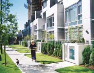
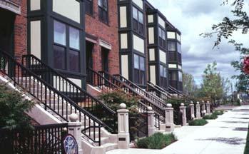
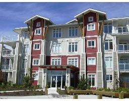
10 Potential Housing Forms - What do you think? Ground Floor Retail in a Residential Building Podium Ground Floor Townhouses in a Podium with Point Towers


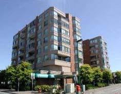
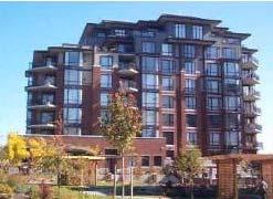

11 Potential Housing Forms - What do you think? Three to Four-Storey Residential Buildings Five to Six-Storey Residential Buildings Possibly with Retail at the Ground Level

12 Completing 152A Street from 16 Ave to 18 Ave - What do you think? Option A Create a through street on alignment with existing section of 152A This option requires the purchase of 8 houses and could accommodate angled parking and a greenway path between 17 and 18 Avenues Between 16 and 17 Avenues, the road would be two travel lanes and parallel parking Option B Create a through street with two travel lanes and parallel parking similar to the existing section of 152A The intersection would not be aligned at 17 Avenue This option requires the purchase of 4 houses and could accommodate standard sidewalks and street trees Between 16 and 17 Avenues, the road would be two travel lanes and parallel parking
13 Next Steps Results of the Public Open House and comment sheets will be reviewed and reported to Council More detailed land use and urban design studies will be done Plan options will be developed that will consider building architecture, public realm design, density, pedestrian routes, public open spaces, and vehicular circulation plan Plan options will be reviewed with the Steering Committee A second Public Open House will be held to receive feedback on plan options A preferred option will be refined and design guidelines will be developed A Transportation Plan will be developed that illustrates the proposed transportation system for vehicles, pedestrians, bicycles, transit, and parking management An Implementation Plan will be prepared, with recommendations for transportation and servicing improvements, and financing strategies The preferred option will be reviewed with the Steering Committee and the Public Thank you for attending this Public Open House and filling out the questionnaire with your ideas and comments

14 Aerial Photograph of Semiahmoo Town Centre Study Area
Introduction. Intent of the Plan. Urban Design and Land Use Approach
 Introduction Intent of the Plan This is the Second Public Open House for the. The intent of the is to update current City policy in order to encourage future development that will ensure a diverse, lively,
Town Center (part of the Comprehensive Plan)
") Town Center (part of the Comprehensive Plan) Mercer Island Town Center Looking North (2014) In 1994, a year-long process culminated in a set of design guidelines and code requirements for the Town Center
Town Center (part of the Comprehensive Plan) Mercer Island Town Center Looking North (2014) In 1994, a year-long process culminated in a set of design guidelines and code requirements for the Town Center
ELMVALE ACRES SHOPPING CENTRE MASTER PLAN
 ELMVALE ACRES SHOPPING CENTRE MASTER PLAN Contents 1.0 INTRODUCTION... 2 2.0 LOCATION... 2 3.0 EXISTING CONTEXT... 2 4.0 VISION & GUIDING PRINCIPLES... 2 5.0 LAND USE AND BUILT FORM... 4 5.1 St. Laurent
South Davis County COMMUNITY SPOTLIGHT
 South Davis County COMMUNITY SPOTLIGHT Davis/SLC Community Connector Bus Rapid Transit line connecting SLC & Davis County RTP Phase 1 Project Generate 3,100 average weekday riders Relieve congestion on
WEST LOOP DESIGN GUIDELINES CHECKLIST
 WEST LOOP DESIGN GUIDELINES CHECKLIST Section 1.0 General Strategies 1.1 DESIGN EXCELLENCE: ENCOURAGE HIGH QUALITY AND INNOVATIVE DESIGN OF NEW BUILDINGS WITHIN THE WEST LOOP WITHOUT BEING PRESCRIPTIVE
Policies and Code Intent Sections Related to Town Center
 Policies and Code Intent Sections Related to Town Center The Town Center Vision is scattered throughout the Comprehensive Plan, development code and the 1994 Town Center Plan. What follows are sections
appendix and street interface guidelines
 appendix five: building and street interface guidelines appendix 5 building and street interface guidelines BOULEVARDS Boulevards are generally characterized by higher levels of traffic movement at higher
WHAT WE HEARD REPORT - Summary Bonnie Doon Mall Redevelopment Application (LDA )
") WHAT WE HEARD REPORT - Summary Bonnie Doon Mall Redevelopment Application (LDA18-0184) PROJECT ADDRESS: 1 Bonnie Doon Shopping Centre NW, 8420 85 Street NW & 8715 85 Street NW PROJECT DESCRIPTION: Rezoning
WHAT WE HEARD REPORT - Summary Bonnie Doon Mall Redevelopment Application (LDA18-0184) PROJECT ADDRESS: 1 Bonnie Doon Shopping Centre NW, 8420 85 Street NW & 8715 85 Street NW PROJECT DESCRIPTION: Rezoning
PLAN ELEMENTS WORKSHOP. April 5, 2016
 PLAN ELEMENTS WORKSHOP April 5, 2016 needs more housing. But there is no one-size fits-all solution. Every neighborhood has its own character. In some places, density is not only appropriate it is badly
BROOKHILL NEIGHBORHOOD MODEL ZONING MAP AMENDMENT PREFACE TO APPLICATION
 BROOKHILL NEIGHBORHOOD MODEL ZONING MAP AMENDMENT PREFACE TO APPLICATION June 15, 2015 Revised: August 1, 2016 I. VISION Brookhill is a proposed community based upon the principles of Albemarle County
New-Cast Mixed-use Development Proposal King Street West, Newcastle, Ontario
 URBAN DESIGN BRIEF New-Cast Mixed-use Development Proposal King Street West, Newcastle, Ontario TABLE OF CONTENTS: 1.0 Executive Summary 2.0 Creating Vibrant and Sustainable Urban Places: Excerpts from
Redevelopment of Ajax Plaza Area Public Open House Meeting February 19, 2015 Questions and Answers
 Redevelopment of Ajax Plaza Area Public Open House Meeting February 19, 2015 Questions and Answers Redevelopment of Ajax Plaza Area Why is the redevelopment of the Ajax Plaza important to the revitalization
9.5 Austin Heights Neighbourhood Plan
 City of Coquitlam Austin Heights Neighbourhood Plan 1.0 BACKGROUND 1 1.1 Welcoming Innovative and Sustainable Investment in Neighbourhoods 1 1.2 Relationship with the CWOCP and the SWCAP 1 1.3 Austin Heights
Shared Principles and Emerging Plan Directions
 Shared Principles and Emerging Plan Directions Introduction Since the Fairfield Neighbourhood planning process launched in June 2016, we have heard from many residents, businesses, groups and other people
The Master Plan Framework
 The Master Plan Framework The East Harbour Master Plan advances the development of 60 acres of former industrial lands east of the Don River. The Master Plan outlines a vision for a vibrant, transit-oriented
[PLANNING RATIONALE] For Site Plan Control and Lifting of Holding Zone By-Law 101 Champagne Avenue. May 23, 2014
![[PLANNING RATIONALE] For Site Plan Control and Lifting of Holding Zone By-Law 101 Champagne Avenue. May 23, 2014](/thumbs/75/71599615.jpg "[PLANNING RATIONALE] For Site Plan Control and Lifting of Holding Zone By-Law 101 Champagne Avenue. May 23, 2014") [PLANNING RATIONALE] For Site Plan Control and Lifting of Holding Zone By-Law 101 Champagne Avenue May 23, 2014 Contents 1.0 Introduction... 2 2.0 Site Context... 2 2.1 Adjacent Uses... 2 Figure 1: Site
[PLANNING RATIONALE] For Site Plan Control and Lifting of Holding Zone By-Law 101 Champagne Avenue May 23, 2014 Contents 1.0 Introduction... 2 2.0 Site Context... 2 2.1 Adjacent Uses... 2 Figure 1: Site
Small Area Plan. South Gateway
 Small Area Plan Adopted May 12, 2008 South Gateway Purpose. The South Gateway Small Area Plan defines the City s expectations for the future of the southern entrance to the City at Interstate 85 and Highway
DOWNTOWN GEORGETOWN PLANNING STUDY
 DOWNTOWN GEORGETOWN PLANNING STUDY Community Workshop #3 Thursday, May 4, 08 The Planning Partnership OVERVIEW OF STUDY, PROCESS & MILESTONES We are here PURPOSE OF THE STUDY To develop a clear vision
City of Farmington. Downtown Plan. Amendment to the 1998 Master Plan Adopted October 11, 2004
 City of Farmington Amendment to the 1998 Master Plan Adopted October 11, 2004 Introduction Planning Background 1 Scope and Components of the Plan Amendment 2 Concept Introduction 3 Plan Concepts 3 Conceptual
MALL REVITALIZATION CASE STUDIES
 MALL REVITALIZATION CASE STUDIES DECEMBER 9, 2012 MALL REVITALIZATION OVERVIEW Introduction Sample Case Studies prepared for Lacey Woodland District Steering Committee as it considers strategies to revitalize
Regency Developments. Urban Design Brief. Holyrood DC2 Rezoning
 Regency Developments Urban Design Brief Holyrood DC2 Rezoning Stantec Consulting Ltd. 7-31-2017 1. Overview Regency Developments intends to rezone the lands located at 8510 and 8511 93 Avenue, within the
Workshop 3. City of Burlington Waterfront Hotel Planning Study. September 14, The Planning Partnership
 Workshop 3 City of Burlington Waterfront Hotel Planning Study September 14, 2017 The Planning Partnership The Waterfront Hotel Planning Study 01 The Brant & Lakeshore Planning Study will establish a Strategic
Clairtrell Area Context Plan
 Clairtrell Area Context Plan March 2005 Urban Development Services City Planning Contents 1. Introduction... 4 2. Development Structure... 6 2.1 Streets... 7 2.1.1 Sheppard Avenue and Bayview Avenue...
PORT WHITBY COMMUNITY
 PORT WHITBY COMMUNITY SECONDARY PLAN UPDATE COMMUNITY IMPROVEMENT PLAN URBAN DESIGN GUIDELINES September 2015 DRAFT PROPOSED AMENDMENT NUMBER # to the Whitby Official Plan PURPOSE: The intent of this Amendment
38 Queen s University Campus Master Plan Part 1
 38 Queen s University Campus Master Plan Part 1 46 The Campus at the City Scale Chapter 4 The Campus at the City Scale 39 Queen s is an urban University centrally located in Kingston. Decisions made by
LUNDY S LANE COMMUNITY IMPROVEMENT PLAN STUDY
 PUBLIC INFORMATION MEETING #2 October 12, 2016 LUNDY S LANE COMMUNITY IMPROVEMENT PLAN STUDY AGENDA 5:00 to 5:30pm: Open House 5:30 to 6:15pm: Presentation 6:15 to 7:00pm: Individual paced workshop with
Moody Centre Station TOD Area Today
 Moody Centre Station TOD Area Today WHAT IS a transit-oriented Murray Street development area? A Transit-Oriented Development (TOD) Area is a dense, walkable residential and commercial area built to support
EXISTING COMPREHENSIVE PLAN
 EXISTING COMPREHENSIVE PLAN Town Center Land Use Element: V. LAND USE POLICIES Town Center Mercer Island's business district vision as described in "Your Mercer Island Citizen-Designed Downtown" was an
Create Policy Options Draft Plan Plan Approval. Public Consultation Events. Phase 2
 Background Grandview-Woodland Community Plan In the spring of 2012, the City of Vancouver embarked on a comprehensive community planning program in the Grandview-Woodland neighbourhood. The process has
LOW DENSITY RESIDENTIAL
 LOW DENSITY RESIDENTIAL Corner lots with coach houses to increase diversity, provide unity to the streetscape and increase eyes on the street. Garages and ancillary units accessed via rear lanes. Parking
DRAFT. 10% Common Open Space
 % OF CHARLOTTE IS CATEGORIZED AS A. LAND USES : Placeholder map displaying location of Place Type GOALS: Accommodate XX% of future growth. Provide a concentration of primarily commercial and civic activity
Further input invited as Colchester Growth Strategy nears final phase
 IUE 3 / NOVEMBER 2015 Further input invited as Colchester Growth trategy nears final phase trathcona County is seeking public feedback as it enters the final phase of work on a Growth Management trategy
Tyvola & Archdale Transit Station Area Plan. June 5, 2008
 Tyvola & Archdale Transit Station Area Plan Second Public Meeting June 5, 2008 Presentation Outline 1. Purpose and Process 2. Station Area Overview 3. Plan Recommendations 4. Comments Received and Proposed
ADMINISTRATION RECOMMENDATION(S) 2018 January 25. That Calgary Planning Commission recommend APPROVAL of the proposed Land Use Amendment.
 2018 January 25. That Calgary Planning Commission recommend APPROVAL of the proposed Land Use Amendment.") Page 1 of 9 EXECUTIVE SUMMARY This land use amendment proposes to redesignate a parcel from DC Direct Control District to Multi-Residential Contextual Grade-Oriented (M-CG) District to allow for multi-residential
Page 1 of 9 EXECUTIVE SUMMARY This land use amendment proposes to redesignate a parcel from DC Direct Control District to Multi-Residential Contextual Grade-Oriented (M-CG) District to allow for multi-residential
Community Design Guidelines. Port Wallace DRAFT
 Community Design Guidelines Port Wallace DRAFT Energy 1 2 3 Nature Movement Connections Built Form DRAFT Layout Energy 1 Nature Community Design Guidelines GREAT COMMUNITIES PROTECT, CELEBRATE, AND CONSERVE
Tyvola & Archdale Transit Station Area Plan. May 15, 2008
 Tyvola & Archdale Transit Station Area Plan First Public Meeting May 15, 2008 Presentation Outline 1. Purpose and Process 2. Station Area Overview 3. Plan Recommendations Vision Land Use Transportation
Welcome. Walk Around. Talk to Us. Write Down Your Comments
 Welcome This is an information meeting introducing the applications for proposed redevelopment of the Yorkdale Shopping Centre site at 3401 Dufferin Street and 1 Yorkdale Road over the next 20+ years,
Welcome! to Keller Town Hall
 Welcome! to Keller Town Hall Keller Town Center Planning a New Downtown What is Keller Town Center? A new, growing downtown district planned as an urban village A combination of retail and office spaces,
Queensborough Eastern Neighbourhood Node. Community Open House
 Queensborough Eastern Community Open House The Vision The Queensborough Eastern will become the heart of eastern Queensborough. Through a sensitive mix of viable commercial and residential areas, the neighbourhood
Urban Planning and Land Use
 Urban Planning and Land Use 701 North 7 th Street, Room 423 Phone: (913) 573-5750 Kansas City, Kansas 66101 Fax: (913) 573-5796 Email: planninginfo@wycokck.org www.wycokck.org/planning To: From: City Planning
The University District envisions, in its neighborhood
 Envisioning the University District Link Light Rail in Seattle s neighborhoods CIY OF SEALE CONCEP-LEVEL SAION AREA PLANNING RECOMMENDAION RESOLUION # 30165 EXHIBI L Vision 08.2000 he University District
Public Open House. Yonge Street and Bernard Avenue (Bernard KDA) Planning Study Update Town of Richmond Hill. March 30, 2017
 Planning Study Update Town of Richmond Hill. March 30, 2017") Public Open House Yonge Street and Bernard Avenue (Bernard KDA) Planning Study Update Town of Richmond Hill March 30, 2017 Open House Review of Project Purpose and Process Policy Refresher Highlights of
Public Open House Yonge Street and Bernard Avenue (Bernard KDA) Planning Study Update Town of Richmond Hill March 30, 2017 Open House Review of Project Purpose and Process Policy Refresher Highlights of
Tysons Circulator Study: Process and Preliminary Results Summary. March 2012
 Tysons Circulator Study: Process and Preliminary Results Summary March 2012 Background: 1. The Comprehensive Plan for the Tysons Corner Urban Center calls for a System of Circulators in Tysons Corner to:
THEMES, VISION, + PRINCIPLES
 CHAPTER 2: THEMES, VISION, + PRINCIPLES This page intentionally left blank. 20 VISION DRAFT AUGUST 2018 2 2 THEMES, VISION, + GUIDING PRINCIPLES The Key Themes, Vision, and Guiding Principles presented
1.0 Purpose of a Secondary Plan for the Masonville Transit Village
 Report to Planning and Environment Committee To: Chair and Members Planning & Environment Committee From: John M. Fleming Managing Director, Planning and City Planner Subject: Masonville Transit Village
Crofton Manor 2803 West 41st Avenue WHAT WE HEARD. Public Consultation: Phase 1
 Crofton Manor 2803 West 41st Avenue WHAT WE HEARD Public Consultation: Phase 1 Background CROFTON MANOR What s Happening The City of Vancouver is undertaking a planning and public engagement process to
Civic Center District
 Civic Center District The Civic Center district is the civic and social heart of Warrenville, containing such public buildings as the City Hall, Warrenville Public Library, Police Station, Park District
Old Town Neighborhoods Plan. Choices Event Wednesday, December 9, 2015
 Old Town Neighborhoods Plan Choices Event Wednesday, December 9, 2015 Agenda 6:00 6:10 p.m. Welcome + Sign In 6:10 6:30 p.m. Presentation 6:30 8:00 p.m. Workshop + Open House Seeking your input on: Neighborhood
LAND USE AMENDMENT DOWNTOWN COMMERCIAL CORE (WARD 7) MACLEOD TRAIL SE AND 5 AVENUE SE BYLAW 254D2017
 MACLEOD TRAIL SE AND 5 AVENUE SE BYLAW 254D2017") Page 1 of 10 EXECUTIVE SUMMARY This Land Use Amendment application seeks to redesignate a full downtown block (currently the YWCA site) from a Direct Control based on the CM-2 District (Land Use Bylaw
Page 1 of 10 EXECUTIVE SUMMARY This Land Use Amendment application seeks to redesignate a full downtown block (currently the YWCA site) from a Direct Control based on the CM-2 District (Land Use Bylaw
Official Plan Review: Draft Built Form Policies
 PG.30.1 REPORT FOR ACTION Official Plan Review: Draft Built Form Policies Date: May 15, 2018 To: Planning and Growth Management Committee From: Chief Planner and Executive Director, City Planning Division
Seneca Meadows. Block 4 Locate office, technology, and medical development adjacent to I Screen views of garage structures from I-270.
 Seneca Meadows Seneca Meadows has an industrial park in its southern end and a mixed-use employment area planned for the north end. The district benefits from extensive I-270 visibility, stream valley
Northwest Rail Corridor and US 36 BRT Development Oriented Transit Analysis 4.4 STATION AREA FINDINGS
 4.4 STATION AREA FINDINGS Each station is different, and each one requires a separate set of recommendations based on the vision for the site. This section outlines an initial TOD strategy and recommendations
4- PA - LD - LIVELY DOWNTOWN. LD - Background
 4- PA - LD - LIVELY DOWNTOWN LD - Background The downtown has been the service centre for the community since the city s inception and the area continues to supply people with their personal services,
Downtown Langley Transit Exchange Concept Plan
 Downtown Langley Transit Exchange Concept Plan Presented to TransLink and the City of Langley September 13, 2013 Prepared by: In collaboration with: TABLE OF CONTENTS 1 INTRODUCTION... 1 1.1 Background
TSAWWASSEN TOWN CENTRE REDEVELOPMENT BLOCK A 004
 Current Context The context for the project includes storey multi-family residential to the northwest, a TD bank immediately north, highway oriented commercial to the east, a surface parking lot to the
Table of Contents. Elm Avenue Improvement Plan City of Waco, Texas. Introduction 1. Existing Context 1 Figure 1 2.
 Table of Contents Introduction 1 Existing Context 1 Figure 1 2 Plan Guidelines 3 Future Urban Form 4 The West-End 4 Main Street 6 The East-End 7 Figure 2 9 Public Improvement Recommendations 7 General
FLEETWOOD TOWN CENTRE
 FLEETWOOD TOWN CENTRE LAND USE PLAN and URBAN DESIGN CONCEPT PLAN DECEMBER, 2000 Planning and Development Department Cloverdale Town Centre Land Use Plan and Urban Design Concept FLEETWOOD TOWN CENTRE
SECTION ONE: INTRODUCTION. introduction
 introduction 1 INTRODUCTION Since it was first established in 1843 as a trading post for the Hudson s Bay Company, Victoria has evolved into a Provincial capital city that is recognized across Canada and
WELCOME and introduction
 1 WELCOME and introduction Mobility Hub Locations within Burlington STUDY OVERVIEW STUDY OBJECTIVES The City of Burlington is developing four Area Specific Plans, one for each of Burlington s Mobility
REPORT BACK BROADSHEET 3 May 2016
 Paddington Place REPORT BACK BROADSHEET May 06 Architects and planners should work with the community first and then thinking about developers profits second. - Quote from participant at Paddington Place
Land Use Amendment in Southwood (Ward 11) at and Elbow Drive SW, LOC
 at and Elbow Drive SW, LOC") 2018 November 15 Page 1 of 10 EXECUTIVE SUMMARY This land use amendment application was submitted by Rick Balbi Architect on 2017 August 31 on behalf of Sable Developments Ltd, and with authorization from
2018 November 15 Page 1 of 10 EXECUTIVE SUMMARY This land use amendment application was submitted by Rick Balbi Architect on 2017 August 31 on behalf of Sable Developments Ltd, and with authorization from
Complete Street and the EA Process. Queen Street Corridor- Brampton Golden Mile
 Complete Street and the EA Process. Queen Street Corridor- Brampton Golden Mile Contents A. Vision B. Overview of Existing Conditions C. Queen Street Complete Street Criteria D. A quick look at the Queen
CONTENTS 8.0 LAND USE 8.1 GENERAL LAND USE 8.2 RESIDENTIAL 8.3 MIXED USE 8.4 COMMERCIAL 8.5 EMPLOYMENT LANDS
 8-2 Land Use 8.0 LAND USE CONTENTS 8.1 GENERAL LAND USE 8.1.1 Uses provided for in all Land Use Designations 8.1.2 Uses prohibited in Hazardous Lands, Hazardous Sites and Special Policy Areas 8.1.3 Uses
Historic Yonge Street HCD Study Public Meeting #2
 Historic Yonge Street HCD Study Public Meeting #2 March 26, 2014 Archaeological Services Inc. Philip Goldsmith Architect Agenda: 7:00 p.m. Open House 7:30 p.m. Welcome and Presentation 8:00 p.m. Questions
Commercial Node Plan Devine Street/Jackson Blvd. COLUMBIA, SC
 Commercial Node Plan Devine Street/Jackson Blvd. COLUMBIA, SC 9.17.13 AGENDA 1 Introductions 2 Project Update 3 Concepts 4 Recommendations 5 Next Steps Introductions Project Update Process 5-Phase Process
Public Consultation Summary: Lakeview Place Making Workshop January 30, 2008.
 Page 1 of 11 Public Consultation Summary: Lakeview Place Making Workshop January 30, 2008. 1.0 Introduction: On January 30, 2008 the City of Mississauga, in conjunction with the consulting team of Brook
URBAN DESIGN BRIEF. 2136&2148 Trafalgar Road. Town of Oakville
 URBAN DESIGN BRIEF 2136&2148 Trafalgar Road Town of Oakville Prepared By: METROPOLITAN CONSULTING INC For 2500674 Ontario Inc November 2016 TABLE OF CONTENTS Page No. 1.0 Introduction/Description of Subject
Lehigh Acres Land Development Regulations Community Planning Project
 Lehigh Acres Land Development Regulations Planning Effort Summary In July, 2010 Commissioner Frank Mann invited the Lehigh Acres community to start discussing how to achieve their recently adopted community
John M. Fleming Managing Director, Planning and City Planner. Old East Village Dundas Street Corridor Secondary Plan Draft Terms of Reference
 Report to Planning and Environment Committee To: From: Subject: Chair and Members Planning & Environment Committee John M. Fleming Managing Director, Planning and City Planner Old East Village Dundas Street
Rapid Transit Implementation Working Group Transit Oriented Development and Transit Villages January 12, 2017
 Rapid Transit Implementation Working Group Transit Oriented Development and Transit Villages January 12, 2017 Purpose of Presentation Highlight opportunities for Transit-Oriented Development in London
New Auburn Village Center Study Auburn, Maine
 Auburn, Maine Option Review Summary Prepared for: Androscoggin Transportation Resource Center and City of Auburn Prepared by: T.Y. Lin International MRLD October 10, 2013 1. Introduction This memo summarizes
ARLINGTON COUNTY, VIRGINIA
 ARLINGTON COUNTY, VIRGINIA County Board Agenda Item Meeting October 15, 2005 DATE: September 28, 2005 SUBJECT: Request to Advertise the adoption of the 2005 Clarendon Sector Plan C. M. RECOMMENDATION:
DRAFT ROOSEVELT ROAD. District Recommendations. Figure 5.23 The Roosevelt Road Corridor
 CHAPTER 5 Figure 5.23 The Road Corridor Road will develop as a mixed-use corridor, emphasizing regional retail, west of the river and mixed-use development east of the river. KEY RECOMMENDATIONS 1. High
Establish a network of streetscaped vehicle and pedestrian routes that connect within and outside the Plan area.
 This Plan s urban design goals are to create an urban scale, walkable community with connections to transit, parks, and services and with amenities and facilities for residents and employees. The 1992
St. Clair Avenue West Area Transportation Master Plan
 1 (Between Keele Street and Old Weston Road) Public Information Centre 1 December 2, 2015 2 Welcome Welcome to the first Public Information Centre for the St. Clair Avenue West Area. The panels will present
C I T Y O F T O R O N T O L A W R E N C E A V E N U E E A S T S T U D Y. Northwest Corner of Birchmount Road and Lawrence Avenue East
 C I T Y O F T O R O N T O A P P E N D I X A Northwest Corner of Birchmount Road and Lawrence Avenue East 92 DILLON CONSULTING LTD. - J.C. WILLIAMS GROUP LTD. APPENDIX B LAWRENCE AVENUE EAST STUDY SUMMARY
Developer s Program. The Station at East 54
 Developer s Program The Station at East 54 Existing Conditions The Station at East 54 is proposed for a 1.12 acre site at the northeast corner of Hamilton Road and Prestwick Road, tucked between the East
PROPOSED REDEVELOPMENT OF THE GLEN ABBEY GOLF CLUB. STREETSCAPE DESIGN STUDY (excerpt from the Urban Design Brief) TOWN OF OAKVILLE.
 TOWN OF OAKVILLE.") PROPOSED REDEVELOPMENT OF THE GLEN ABBEY GOLF CLUB STREETSCAPE DESIGN STUDY (excerpt from the Urban Design Brief) TOWN OF OAKVILLE OCTOBER, 2016 for 2.4.2 STREETS Streets are the single largest component
PROPOSED REDEVELOPMENT OF THE GLEN ABBEY GOLF CLUB STREETSCAPE DESIGN STUDY (excerpt from the Urban Design Brief) TOWN OF OAKVILLE OCTOBER, 2016 for 2.4.2 STREETS Streets are the single largest component
Study Area. Capitol Way. Greening America s Capitals 11/13/2014. A Greening America s Capitals Project
 Olympia, WA: Greening Capitol Way Supporting Communities move towards sustainability is a priority for the federal government. A Greening America s Capitals Project Office of Sustainable Communities U.S.
Lambeth Main Street Streetscape Improvements
 Lambeth Main Street Streetscape Improvements Open House October 5th, 2017 Agenda 1. Introduction 2. Project Background 3. Context 4. Project Objectives 5. Design Principles & Approach 6. Streetscape Design
Urban Design Manual PLANNING AROUND RAPID TRANSIT STATIONS (PARTS) Introduction. Station Study Areas
 Introduction. Station Study Areas") 111111 PLANNING AROUND RAPID TRANSIT STATIONS (PARTS) Introduction The ION rapid transit system will link Waterloo, Kitchener and Cambridge through a central transit corridor (CTC). There are a number
111111 PLANNING AROUND RAPID TRANSIT STATIONS (PARTS) Introduction The ION rapid transit system will link Waterloo, Kitchener and Cambridge through a central transit corridor (CTC). There are a number
Hockessin Community Redevelopment Plan
 Hockessin Community Redevelopment Plan 3.1 Introduction The Community Redevelopment Plan for the Village of Hockessin is the result of the people s vision for a distinct village center that serves as the
CHAPTER 7: Transportation, Mobility and Circulation
 AGLE AREA COMMUNITY Plan CHAPTER 7 CHAPTER 7: Transportation, Mobility and Circulation Transportation, Mobility and Circulation The purpose of the Transportation, Mobility and Circulation Chapter is to
ROAD CLOSURE AND LAND USE AMENDMENT SILVER SPRINGS (WARD 1) NORTHEAST OF NOSEHILL DRIVE NW AND SILVER SPRINGS ROAD NW BYLAWS 2C2018 AND 29D2018
 NORTHEAST OF NOSEHILL DRIVE NW AND SILVER SPRINGS ROAD NW BYLAWS 2C2018 AND 29D2018") Page 1 of 19 EXECUTIVE SUMMARY This application proposes redesignating two parcels in the community of Silver Springs from Special Purpose Future Urban Development (S-FUD) District and undesignated road
Page 1 of 19 EXECUTIVE SUMMARY This application proposes redesignating two parcels in the community of Silver Springs from Special Purpose Future Urban Development (S-FUD) District and undesignated road
PLANNING ADVISORY BOARD AGENDA OCTOBER
 ! City of Langley PLANNING ADVISORY BOARD AGENDA OCTOBER 1, 2014 3-5pm LANGLEY CITY HALL - 112 2 nd Street, Langley WA 1) Call to Order and Roll Call 2) Approval of the Minutes September 10, 2014 3) Public
The Vision. Photo provided by The Minervini Group. 46 Vision, Objectives & Strategies
 Vision, Objectives & Strategies The is the public framework and guide for future development of the Grand Traverse Commons. The establishes public polices for infrastructure, the preservation of natural
Bourne Downtown Site Planning
 Prepared for: The Town of Bourne, MA In Cooperation with: Bourne Financial Development Corporation Prepared by:, Inc. June 24, 2009 Table of Contents Introduction and Summary... 1 Site Existing Conditions...
SLIDE TITLE TRANSIT-ORIENTED DEVELOPMENT PLAN RED-PURPLE BYPASS STUDY AREA PUBLIC MEETING #2 RED AND PURPLE MODERNIZATION. RPM TOD Plan Update
 SLIDE TITLE TRANSIT-ORIENTED DEVELOPMENT PLAN RED-PURPLE BYPASS STUDY AREA PUBLIC MEETING #2 RED AND PURPLE MODERNIZATION 1 SLIDE TITLE AGENDA Project Introduction TOD s and Development Trends Real Estate
SECTION TWO: Urban Design Concepts
 SECTION TWO: Urban Design Concepts The Gardnerville Plan for Prosperity shapes economic opportunities presented by regional growth. The Urban Design Concepts provide policies and concepts for land use,
Highland Village Green Design Guidelines
 Highland Village Green Design Guidelines Publishing Information Title Highland Village Green Design Guidelins Author The City of Calgary Status DRAFT - Proposed document subject to changes Additional Copies
THE NEIGHBORHOOD TODAY
 THE NEIGHBORHOOD TODAY CORE AREA VISION How are we Good Urbanism A Site s DNA thinking about Elements of great Unique elements urban communities embedded in a place the site and design? ELEMENTS LIKE:
Silverdale Regional Center
 Silverdale Regional Center Vision for Silverdale Regional Center The Silverdale Regional Center Plan (Plan) will guide the evolution of the Silverdale Regional Center from a collection of strip malls and
Mavis Road Class Environmental Assessment
 Mavis Road Class Environmental Assessment Public Information Centre #2 Wednesday November 9, 2016 6:00 to 8:00 p.m. Please sign in and complete a comment sheet Review the displays on your own or join in
CHAPTER 5: GUIDING PRINCIPLES
 CHAPTER 5: GUIDING PRINCIPLES The following 10 principles were developed based on public consultation, planning policy and the background analysis conducted during Phase 1. The Guiding Principles significantly
Courtice Main Street Study Community Vision Workshop PLANNING SERVICES DEPARTMENT
 Courtice Main Street Study Community Vision Workshop PLANNING SERVICES DEPARTMENT July 22, 2009 Tonight s Meeting 7:00 pm Introduction David Crome, Director of Planning 7:05 Presentation Stasia Bogdan,
Mark-up of the effect of the proposed Bronte Village Growth Area OPA No.18 on the text of section 24, Bronte Village, of the Livable Oakville Plan
 Mark-up of the effect of the proposed Bronte Village Growth Area OPA No.18 on the text of section 24, Bronte Village, of the Livable Oakville Plan Notes: This document is provided for information purposes
DEFINED VILLAGE CENTRES & NEIGHBOURHOODS
 DEFINED VILLAGE CENTRES & NEIGHBOURHOODS residents in Nanoose Bay support focusing attractive, planned future development in Red Gap Centre and the Area s neighbourhood centres. In addition, the development
Newton Town Centre. Land Use, Urban Design & Transportation Plan
 Newton Town Centre Land Use, Urban Design & Transportation Plan Public Workshop - June 2-4, 2009 6:15 6:30 Sign-in & conversations Tonight s Agenda 6:30 6:55 Project introduction and summary of previous
The Cambie Corridor 2015 Fall workshop series. What we heard WORKSHOP OUTLINE
 The Cambie Corridor 2015 Fall workshop series W 16 AVE Area 5 CAMBIE CORRIDOR Phase 3 What we heard ovember 21, 2015, 9am-noon, 1:30-4:30pm Peretz Centre 89 Participants* WORKSHOP OUTLIE Introductions
A. Selma Park, Davis Bay and Wilson Creek
 A. Selma Park, Davis Bay and Wilson Creek This waterfront neighbourhood consists of three separate community areas, linked by Highway 101, but with different character, land use patterns and future potential.