Goals for Tonight s Meeting
|
|
|
- Tracey Jenkins
- 5 years ago
- Views:
Transcription
1 South Anthony Boulevard Railroad Grade Separation Study Report to Community November 30, 2011 Andorfer Commons Theatre Indiana Tech University
2 Goals for Tonight s Meeting Recap of the meeting from last November Provide an overview of the options that were developed for the feasibility study Present recommended option Present opportunities for enhancement of the project Solicit input from attendees Respond to questions/comments

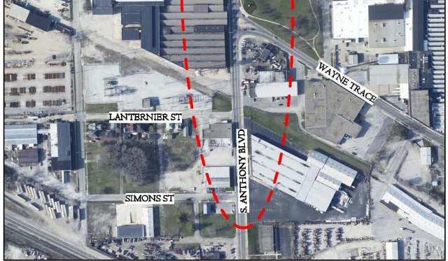
3 Project Location
4 Statistics History of congestion South Anthony Boulevard over 13,000 vehicles per day Wayne Trace over 7,000 vehicles per day Norfolk Southern Railroad -50 trains per day per Norfolk Southern Trucks and large emergency vehicles unable to use corridor Barrier to investment and development
5 Goals Develop a long-term solution Assure public input on the solution Meet the long-term needs of the community Enhance investment opportunities on Anthony Boulevard Maximize connectivity for Southeast Fort Wayne Give this vicinity a sense of place and placemaking Integrate historic aspects and enhance user experience Provide structures with a 75 to 100 year life expectancy
6 Public Involvement Public Introduction November 18, 2010 Focus Group Sessions Early 2011 Urban Enterprise Association Board Corridor and Area Businesses City Council Members Local Government Leaders Community Leaders Neighborhood Residents Transportation and Emergency services Majority of Focus Group participants noted a grade separation was needed
7 Respect this area, its history, its commerce, and its people. Do something great, make this a better place, or don t do anything at all. Train Blockages and Area Street Usage Anthony Boulevard is vital to area travel Frequent train blockages have stifled business and housing development School Bus Crossings Complaints from businesses and delivery companies Significant support for keeping Winter Street open Concerns raised about trains parking for long periods Neighborhood residents report frequent detours to Hanna Street underpass or east to the aging EdsallStreet overpass Public safety officials try to avoid the area due to potential delays
8 Projected Construction Impacts Concerns regarding impact on businesses if Anthony Boulevard is closed during construction. Current train avoidance strategies would work for most during potential construction closures. There was support for keeping Anthony Boulevard open as much as possible during construction. Sensitive Features to Be Protected Protect existing Anthony Boulevard businesses to the maximum extent possible. Protect Shepherd of the City Church and keep it from harm. Limit the impacts to remaining viable houses.
9 Recommended Area Improvements Lighting Pedestrian and bicycle connectivity Bus stops Neighborhood placemaking Greenspacingand landscaping Extend improvements beyond rail crossing Include private property
10 Recommended Theme When Improvements are Completed Urban not suburban Celebrate history Use historic materials and decorative elements Preserve Tokheim Tower Public art
11 Recommended Land Use Improvements Industrial corridor Quality restaurants and shops Quality housing Value of Proceeding With a Grade Separation 80% ranked 4 or 5 100% for certain groups
12 What We Have Studied Defining the impacted area
13 What We Have Studied Defining the impacted area Property ownership and parcel boundaries Fort Wayne GIS Database
14 What We Have Studied Defining the impacted area Property ownership and parcel boundaries Impacts to side streets and accesses Simons Street Lanternier Street Hayden Street Luther Street Lillie Street Fletcher Street
15 What We Have Studied Defining the impacted area Property ownership and parcel boundaries Impacts to side streets and accesses Community impacts connectivity, area quality and placemaking
16 What We Have Studied Defining the impacted area Property ownership and parcel boundaries Impacts to side streets and accesses Community impacts connectivity, area quality and placemaking Norfolk-Southern policies and train traffic volume 50 trains/day 60 MPH No traffic disruption Future 3 rd track 23 clearance above track 16-6 clearance below structure
17 What We Have Studied Defining the impacted area Property ownership and parcel boundaries Impacts to side streets and accesses Community impacts connectivity, area quality and placemaking Norfolk-Southern policies and train traffic volume Anthony Boulevard traffic volume and patterns Traffic study to identify number of lanes required
18 What We Have Studied Defining the impacted area Property ownership and parcel boundaries Impacts to side streets and accesses Community impacts connectivity, area quality and placemaking Norfolk-Southern policies and train traffic volume Anthony Boulevard traffic volume and patterns Topography through the corridor
19 What We Have Studied Defining the impacted area Property ownership and parcel boundaries Impacts to side streets and accesses Community impacts connectivity, area quality and placemaking Norfolk-Southern policies and train traffic volume Anthony Boulevard traffic volume and patterns Topography through the corridor Utilities and potential realignments I&M NIPSCO Comcast Frontier Municipal Utilities
20 What We Have Studied Defining the impacted area Property ownership and parcel boundaries Impacts to side streets and accesses Community impacts connectivity, area quality and placemaking Norfolk-Southern policies and train traffic volume Anthony Boulevard traffic volume and patterns Topography through the corridor Utilities and potential realignments Roadway alignment options Multiple options evaluated Shift to east Maintain in the existing roadway Shift to west
21 What We Have Studied Defining the impacted area Property ownership and parcel boundaries Impacts to side streets and accesses Community impacts connectivity, area quality and placemaking Norfolk-Southern policies and train traffic volume Anthony Boulevard traffic volume and patterns Topography through the corridor Utilities and potential realignments Roadway alignment options Underpass and overpass impacts to nearby businesses and accesses Underpass and overpass impacts to nearby homes and neighborhoods Shift to minimize impacts Maintain traffic through corridor and on Wayne Trace Maintain or re-establish access
22 What We Have Studied Pedestrian and bicycle access
23 What We Have Studied Pedestrian and bicycle access Safety issues Historic preservation issues Stormwater and drainage needs 72 sewer to facilitate draining underpass
24 What We Have Studied Pedestrian and bicycle access Safety issues Historic preservation issues Stormwater and drainage needs Past, present, and potential future land uses Environmental issues Impacts of the railroad underpass to the south, near Creighton Avenue
25 Options Evaluated Everything was on the table Narrowed down to 3 options Three Options Evaluated Overpass with T intersection at Wayne Trace Underpass with roundabout at Wayne Trace Underpass with T intersection at Wayne Trace
26 Overpass with T Intersection at Wayne Trace

27 Overpass with T Intersection at Wayne Trace Attributes Meets project goals Least impact to business access along South Anthony Boulevard Least involvement by the railroad Drawbacks Largest footprint Impacts the largest number of parcels Requires large retaining walls Extends project north to Alliger Street Greater impact to residential area to the north
28 Underpass with Roundabout at Wayne Trace

29 Underpass with Roundabout at Wayne Trace Attributes Meets project goals Provides opportunities for enhancements Eliminates signalized intersection Minimizes impacts to residential area to the north Drawbacks Most disruptive to business access Impacts a large number of parcels Requires additional retaining walls Extends project south of Simons Street Extensive coordination with railroad
30 Underpass with T Intersection at Wayne Trace
31 Underpass with T Intersection at Wayne Trace Attributes Meets project goals Provides opportunities for enhancements Impacts least number of parcels Smallest project footprint Shortest project length Drawbacks Somewhat disruptive to business access Requires additional smaller scale retaining walls Extensive coordination with railroad
32 Recommended Option -Underpass with T Intersection at Wayne Trace Opportunities to enhance user experiences Separation between pedestrian and vehicular facilities Landscaping opportunities Aesthetic treatments to proposed walls Opportunities for placemaking
33 Design Concept, Plan View Underpass with T Intersection

34 Possible View North on Anthony Toward Overpass Existing Condition

35 Possible View South on Anthony Toward Overpass Existing Condition
36 Rail Bridge Design Opportunity
37 Where Do We Go From Here? Review and incorporate feedback from this public meeting Prepare the final feasibility study report Make final feasibility study report available to the public Identify and apply for funding from all potential sources
The transportation system in a community is an
 7 TRANSPORTATION The transportation system in a community is an important factor contributing to the quality of life of the residents. Without a sound transportation system to bring both goods and patrons
Strachan Ave. Overpass Community Design Update. October 26, 2010 Stephen Lipkus Executive Director Georgetown South Project GO Transit
 Strachan Ave. Overpass Community Design Update October 26, 2010 Stephen Lipkus Executive Director Georgetown South Project GO Transit Welcome Program Overview 6:30 8:30 p.m.: Storyboard Review Project
St. Clair Avenue West Area Transportation Master Plan
 1 (Between Keele Street and Old Weston Road) Public Information Centre 1 December 2, 2015 2 Welcome Welcome to the first Public Information Centre for the St. Clair Avenue West Area. The panels will present
Southeast Extension to RidgeGate Parkway Scoping Booklet
 Southeast Extension to RidgeGate Parkway Scoping Booklet PUBLIC SCOPING MEETING SCHEDULE Public Scoping Meeting Wednesday, November 2, 2011 6:00pm to 7:30pm City of Lone Tree Recreation Center Willow Room
Reconstruction Project. Wayzata Task Force Meeting September 3, 2009
 CSAH 101 Reconstruction Project Wayzata Task Force Meeting September 3, 2009 Agenda 700 7:00 Re-Introductions ti 7:05 2008 Activity Recap / 2009 Activities-to-date 7:10 Discussion of Layout Revisions (per
Adelaide Street / Canadian Pacific Railway (CPR) Grade Separation Class Environmental Assessment. Public Information Centre 3
 Grade Separation Class Environmental Assessment. Public Information Centre 3") 1 Adelaide Street / Canadian Pacific Railway (CPR) Grade Separation Study Process and Purpose of PIC 3 2 Study Commencement February 2016 Phase 1: Problem and Opportunity Identify problems and opportunities
1 Adelaide Street / Canadian Pacific Railway (CPR) Grade Separation Study Process and Purpose of PIC 3 2 Study Commencement February 2016 Phase 1: Problem and Opportunity Identify problems and opportunities
WELCOME TO OPEN HOUSE TWO November 28, 2018
 Langstaff Road Weston Road to Highway 7 Class Environmental Assessment Study WELCOME TO OPEN HOUSE TWO November 28, 2018 Please sign in and join our mailing list Study Overview York Region is conducting
PROPOSED IMPROVEMENTS
 IV. PROPOSED IMPROVEMENTS The proposed improvements for each alternative carried forward are discussed below. A. FUNCTIONAL CLASSIFICATION AND ROADWAY CROSS-SECTIONS The classifications of the roadways
Mississippi Skyway Preliminary Engineering Report
 EXECUTIVE SUMMARY Mississippi Skyway Preliminary Engineering Report CITY OF RAMSEY, MINNESOTA DECEMBER 2014 City of RAMSEY EXECUTIVE SUMMARY Project Need and Intent The Mississippi Skyway pedestrian bridge
University Parkway Corridor Plan. Public Workshop Sept. 18, 2017
 University Parkway Corridor Plan Public Workshop Sept. 18, 2017 AGENDA 1. Overview of Process 2. Study Area 3. Components of the Plan 4. What We Know 5. What We Have Heard 6. Tonight s Input 7. Next Steps
The Illinois Department of Transportation and Lake County Division of Transportation. Route 173, including the Millburn Bypass
 The Illinois Department of Transportation and Lake County Division of Transportation welcome you to this Public Hearing for U.S. Route 45 from Illinois Route 132 to Illinois Route 173, including the Millburn
CHAPTER 7: VISION AND ACTION STATEMENTS. Noble 2025 Vision Statement
 CHAPTER 7: VISION AND ACTION STATEMENTS This chapter presents the vision, policy and action statements that transform the comprehensive planning study, an analysis of Noble s past, future trends and community
BeltLine Corridor Environmental Study
 BeltLine Corridor Environmental Study Joint TAC and SAC Meeting December 8, 2008 What We Will Discuss Today Outreach and Agency Coordination Scoping Results Existing Conditions Historical and Archeological
Project Status. Construction is underway for Phase 3. Overall Project Area and Schedule. Schedule of Current Construction Phases.
 I-95 Avenue Interchange Project Status Construction is underway for Phase 3. Overall Project Area and Schedule Phase 0: Completed 2010 Section GR0: Completed in Fallin 2010 Phase 2: Completed Section GR2:
MARINA BAY NEIGHBORHOOD PRESENTATION. City of Richmond Officer Bradley A. Moody Memorial Underpass. April 11, 2012
 MARINA BAY NEIGHBORHOOD PRESENTATION City of Richmond Officer Bradley A. Moody Memorial Underpass April 11, 2012 TEAM INTRODUCTIONS Project Oversight and Approval City of Richmond Formally Richmond Community
Chesterfield County Project Update
 Chesterfield County Project Update SOUTHEAST HIGH SPEED RAIL TIER II ENVIRONMENTAL IMPACT STATEMENT RICHMOND, VA, TO RALEIGH, NC CHESTERFIELD COUNTY, VA OFFICIALS BRIEFING February 2013 Federal Railroad
include playgrounds, sports fields, community gardens and picnic areas.
 DEVELOPMENT PLAN OPEN SPACE SYSTEM OPEN SPACE SYSTEM The neighborhood provides for a range of open space types. The Village Square is an important open space in the neighborhood. It serves as a gathering
Welcome to the. Open House
 Welcome to the 5th Street to Kinsman Road Open House November 14 5:30 7:00 p.m. Please sign in Project Overview In December 2016, City Council adopted SW 5th Street as the preferred alignment to connect
Railyard Alternatives and I-280 Boulevard Feasibility Study. MTA Board Meeting May 6, 2014
 Railyard Alternatives and I-280 Boulevard Feasibility Study MTA Board Meeting May 6, 2014 Planned Infrastructure Major pieces of new infrastructure are planned including: Downtown Rail Extension (DTX)
The West Vaughan Employment Area Secondary Plan Policies
 Part 2: The West Vaughan Employment Area Secondary Plan Policies 2.1 General Policies It is the policy of Council: 2.1.1. That the West Vaughan Employment Area (the WVEA), identified on Schedule 1, will
SH 199 Corridor Master Plan. Community Meeting No. 2 May 31, 2017
 Community Meeting No. 2 May 31, 2017 Transportation Projects On or Near SH 199 SH 199 from 0.3 miles south of FM 1886 to south end of Lake Worth bridge Construct freeway mainlanes and frontage roads 10-Year
Public Meeting #3 May 9, 2009 MVVA Team
 Public Meeting #3 May 9, 2009 MVVA Team Welcome to the third Public Meeting for the Lower Don Lands Municipal Class Environmental Assessment (EA) Infrastructure Master Plan and Keating Channel Precinct
Purpose of Open House #3
 Public Meeting #3 May 9, 2009 MVVA Team Purpose of Open House #3 The main purpose of this Open House is to present and seek input on the: Evaluation of transportation and infrastructure design alternatives
MARINA BAY. City of Richmond Officer Bradley A. Moody Memorial Underpass. April 14, 2010
 MARINA BAY NEIGHBORHOOD G O OO PRESENTATION S O City of Richmond Officer Bradley A. Moody Memorial Underpass April 14, 2010 TEAM INTRODUCTIONS Project Oversight and Approval City of Richmond Richmond Community
Bostwick Road. Municipal Class Environmental Assessment. Public Information Centre #2 June 14, City of London
 Bostwick Road Municipal Class Environmental Assessment Public Information Centre #2 June 14, 2017 Welcome! Welcome to the 2 nd Public Information Centre for the. Representatives from the and the consulting
CHAPTER 7: Transportation, Mobility and Circulation
 AGLE AREA COMMUNITY Plan CHAPTER 7 CHAPTER 7: Transportation, Mobility and Circulation Transportation, Mobility and Circulation The purpose of the Transportation, Mobility and Circulation Chapter is to
TOWN OF WHITBY REPORT RECOMMENDATION REPORT
 TOWN OF WHITBY REPORT RECOMMENDATION REPORT REPORT TO: Council REPORT NO: PL 95-09 DATE OF MEETING: October 13, 2009 PREPARED BY: Planning/Public Works Joint Report FILE NO(S): N/A LOCATION: N/A REPORT
Scope of Services. River Oaks Boulevard (SH 183) Corridor Master Plan
 Corridor Master Plan") Scope of Services River Oaks Boulevard (SH 183) Corridor Master Plan PROJECT AREA The project area consists of the River Oaks Boulevard (SH 183) corridor bounded by SH 199 at the northern end and the Trinity
Scope of Services River Oaks Boulevard (SH 183) Corridor Master Plan PROJECT AREA The project area consists of the River Oaks Boulevard (SH 183) corridor bounded by SH 199 at the northern end and the Trinity
Gratigny Parkway East Extension Project Development & Environment (PD&E) Study
 Study") Gratigny Parkway East Extension Project Development & Environment (PD&E) Study Session 4: Presentation of Charrette Results December 8, 2010 MDX Work Program #: 92407 ETDM#: 11500 Project Location & Description
Gratigny Parkway East Extension Project Development & Environment (PD&E) Study Session 4: Presentation of Charrette Results December 8, 2010 MDX Work Program #: 92407 ETDM#: 11500 Project Location & Description
Eastside Transit Corridor Phase 2 Technical Study Update Community Outreach Meeting February 2017
 Eastside Transit Corridor Phase 2 Technical Study Update Community Outreach Meeting February 2017 Purpose of Tonight s Meeting Recap of Board motion (2014) and technical study process Provide update on
PLAN ELEMENTS WORKSHOP. April 5, 2016
 PLAN ELEMENTS WORKSHOP April 5, 2016 needs more housing. But there is no one-size fits-all solution. Every neighborhood has its own character. In some places, density is not only appropriate it is badly
CHAIR AND MEMBERS CIVIC WORKS COMMITTEE MEETING ON AUGUST 13, 2018
 TO: FROM: SUBJECT: CHAIR AND MEMBERS CIVIC WORKS COMMITTEE MEETING ON AUGUST 13, 2018 KELLY SCHERR, P.ENG., MBA, FEC MANAGING DIRECTOR, ENVIRONMENTAL & ENGINEERING SERVICES AND CITY ENGINEER ADELAIDE STREET
Carlsbad Village Redevelopment Concept Summary of Features
 Carlsbad Village Redevelopment Concept Summary of Features Calthorpe Associates November 5, 2003 The Redevelopment Concept illustrates a vision for the future of Carlsbad Village. The overall vision of
PUBLIC HEARING. Thursday, December 14, 2017 FDOT Urban Office 2198 Edison Avenue Jacksonville, FL 32204
 DISTRICT TWO PUBLIC HEARING I 10 (SR 8) from I 295 to I 95 Project Development & Environment Study Duval County, Florida Financial Project Number 213326 2 22 01 Efficient Transportation Decision Making
WELCOME 50 street cp rail grade separation + road widening. public information session #1 June 26, pm to 8 pm
 WELCOME 50 street cp rail grade separation + road widening public information session #1 June 26, 2018 5 pm to 8 pm session purpose To provide residents, businesses, and users of 50 Street with the opportunity
Welcome. Comprehensive Plan & Transportation Plan Open House November 7, 2012
 Welcome Comprehensive Plan & Transportation Plan Open House November 7, 2012 Agenda Proposed future land use plan Comprehensive Plan strategies Traffic forecasts Future traffic operations Possible future
Illustration of Eastlake Farmer s Cooperative Grain Elevator. Chapter 5: implementation 5-1
 Illustration of Eastlake Farmer s Cooperative Grain Elevator Chapter 5: implementation 5-1 chapter 5: implementation Introduction The Eastlake Subarea Plan includes a wide range of recommendations intended
Right-of-Way Acquisitions and Relocations Technical Memorandum
 Right-of-Way Acquisitions and Relocations Technical Memorandum Southeast Extension Project Lincoln Station to RidgeGate Parkway Prepared for: Federal Transit Administration Prepared by: Denver Regional
Preliminary Design of Major Rehabilitation Works for the Bridge Structure on PTH 1A Over Assiniboine River and CP Rail (Bridge Site No.
 Preliminary Design of Major Rehabilitation Works for the Bridge Structure on PTH 1A Over Assiniboine River and CP Rail (Bridge Site No. 2582-00) Public Consultation Report December 2014 First Street Bridge
City of Toronto. Emery Village Transportation Master Plan
 City of Toronto Emery Village Transportation Master Plan May 2009 Emery Village Transportation Master Plan Toronto, ON May 2009 Consulting Inc. 100 York Blvd., Suite 300 Richmond Hill, ON L4B 1J8 Tel:
East Corridor Final Environmental Impact Statement
 East Corridor Final Environmental Impact Statement Alternatives Considered Operating Plan The requirements for opening day operations versus year 2030 are based on ridership and operations. Opening day
Overall Map. Chicago. St. Louis. Summit. Joliet. Dwight. Pontiac. Bloomington-Normal Lincoln. Springfield. Carlinville. Alton EXPERIENCE IT YOURSELF.
 Overall Map Summit Chicago Bloomington-Normal Lincoln New Station Planned New Station Planned Dwight Pontiac Joliet Pedestrian overpass and second platform planned Higher speed service began in this section
Adelaide Street / Canadian Pacific Railway (CPR) Grade Separation. Public Information Centre #1
 Grade Separation. Public Information Centre #1") 1 Adelaide Street / Canadian Pacific Railway (CPR) Why Are We Here? 2 The purpose of Public Information Centre (PIC) #1 is to: Introduce the study Provide the study background and context Identify the
1 Adelaide Street / Canadian Pacific Railway (CPR) Why Are We Here? 2 The purpose of Public Information Centre (PIC) #1 is to: Introduce the study Provide the study background and context Identify the
ALTERNATIVES. NCDOT made an early decision to first determine how to build the project (construction method) followed by what to build (alternatives).
 followed by what to build (alternatives).") III. ALTERNATIVES A. CONSTRUCTION METHOD ALTERNATIVES NCDOT made an early decision to first determine how to build the project (construction method) followed by what to build (alternatives). One of the
III. ALTERNATIVES A. CONSTRUCTION METHOD ALTERNATIVES NCDOT made an early decision to first determine how to build the project (construction method) followed by what to build (alternatives). One of the
Rosecrans/Marquardt Grade Separation Project. Community Open House Meeting
 Rosecrans/Marquardt Grade Separation Project Community Open House Meeting October 17, 2017 Rosecrans/Marquardt Presentation Agenda 1. Welcome Remarks & Introductions 2. Community Outreach 3. Project Goals
Gold Line Bus Rapid Transit Transit Oriented Development (BRTOD) Helmo Station Area Plan
 Helmo Station Area Plan") Appendix F Gold Line Bus Rapid Transit Transit Oriented Development (BRTOD) Helmo Station Area Plan Introduction and Purpose of the Plan The Gold Line Bus Rapid Transit facility is an eleven-mile dedicated
Appendix F Gold Line Bus Rapid Transit Transit Oriented Development (BRTOD) Helmo Station Area Plan Introduction and Purpose of the Plan The Gold Line Bus Rapid Transit facility is an eleven-mile dedicated
Middlebury RS 0174(8)
") Middlebury RS 0174(8) Preferred Alternative Meeting VT 125 Bridge #13 over Middlebury River August 6, 2012 Presented to Presented by Town of Middlebury VTrans & VHB Introductions: Jennifer Fitch VTrans
Middlebury RS 0174(8) Preferred Alternative Meeting VT 125 Bridge #13 over Middlebury River August 6, 2012 Presented to Presented by Town of Middlebury VTrans & VHB Introductions: Jennifer Fitch VTrans
Reconnecting New Haven: Downtown Crossing
 Reconnecting New Haven: Downtown Crossing Phase 2 Update Introduction to Phase 3 November 16, 2017 City of New Haven, Connecticut Toni N. Harp, Mayor Reconnecting New Haven Introduction Project Overview
TRANSPORTATION COMMITTEE
 TRANSPORTATION COMMITTEE CITY OF OTTAWA Ministry of Transportation Detailed Design Assignment G.W.P.# 4058-01-00 Highway 417 (Ottawa Queensway) Widening & Rehabilitation from Maitland Avenue to Island
A BLUEPRINT FOR BROCKTON A CITY-WIDE COMPREHENSIVE PLAN
 A BLUEPRINT FOR BROCKTON A CITY-WIDE COMPREHENSIVE PLAN Public Meeting October 2016 1 Plan Summary and Discussion Public Meeting May 4 2017 City of Brockton Bill Carpenter, Mayor Department of Planning
I-25 / Rio Bravo Interchange. I-25 / Rio Bravo Interchange. Presenters 11/30/2016 THIRD PUBLIC MEETING DECEMBER 1, 2016 NMDOT CN A300280
 I-25 / Rio Bravo Interchange TONIGHT S MEETING SCHEDULE OPEN HOUSE 6:00 PM TO 6:30 PM PRESENTATION BEGINS AT 6:30 PM Q & A FOLLOWING PRESENTATION CN A300280 / PNA300280 I-25 / Rio Bravo Interchange THIRD
Maplewood Avenue Downtown Complete Street Project
 Maplewood Avenue Downtown Complete Street Project Second Public Meeting January 24, 2018 Welcome and Introduction of Project Team City Planning and Public Works Staff City of Portsmouth Juliet Walker Planning
Access Management: An Overview
 Figures 1-5 Below Evolution of development along a highway. In the early stages, land along the road is used for farming with little traffic generated. As time passes, the highway corridor becomes a de
Century Highfield Sub Area Plan
 Century Highfield Sub Area Plan The Century Highfield Sub Area Plan provides an opportunity to re evaluate the vision that was set forth for this area when the Township conducted a similar planning exercise
Second Line West Pedestrian/Cyclist Crossing of Highway 401 Class EA. Second Line West Pedestrian/Cyclist Crossing of Highway 401 Class EA
 1 1 Purpose of Public Information Centre #2 To provide interested and/or potentially affected stakeholders with an opportunity to participate in the planning and decision-making process for this Municipal
Bostwick Road. Municipal Class Environmental Assessment. October 13, City of London. Bostwick Road Municipal Class Environmental Assessment
 Bostwick Road Municipal Class Environmental Assessment October 13, 2016 Welcome! Welcome to the first Public Information Centre for the Bostwick Road Municipal Class Environmental Assessment. Representatives
AESTHETIC APPEARANCE. Design Guidelines for Grade-Separated Pedestrian, Cyclist and Equestrian Structures
 III. AESTHETIC APPEARANCE The aesthetic qualities of a grade-separated structure are as important as the specific design criteria. For example, a structure may be constructed to the exact criteria set
NORTHEAST RIVER CROSSING FUNCTIONAL PLANNING STUDY
 WELCOME Northeast River Crossing Functional Planning Study Phase 2 Public Meeting 4 to 8 PM Informal drop-in format and discussion tables Meeting Purpose Introduce the Northeast River Crossing Functional
Tyvola & Archdale Transit Station Area Plan. May 15, 2008
 Tyvola & Archdale Transit Station Area Plan First Public Meeting May 15, 2008 Presentation Outline 1. Purpose and Process 2. Station Area Overview 3. Plan Recommendations Vision Land Use Transportation
Presenting a Vision for Thread Lake
 Presenting a Vision for Thread Lake FEBRUARY 20, 2014 SPECIAL THANKS TO: International Academy of Flint Flint River Watershed Coalition South Saginaw Business and Resident Association South Side Neighborhood
PennDOT Public Meeting. S.R. 3044, Section A01 Castle Shannon Boulevard Roadway Improvement Project
 PennDOT Public Meeting S.R. 3044, Section A01 Castle Shannon Boulevard Roadway Improvement Project Mt Lebanon Township, Allegheny County Mt Lebanon Township Municipal Building November 6, 2014 1 Project
ANDERSON PROPERTY SITE ANALYSIS
 ANDERSON PROPERTY SITE ANALYSIS Introduction The Montgomery County Department of Transportation (MCDOT) initiated a feasibility study in the fall of 2012 to evaluate the need for transit service expansion
Hillsborough County MPO Transit Study. Citizens Team Workshop Wednesday, February 28 th, 2006 Hillsborough Community College - Brandon
 Hillsborough County MPO Transit Study Citizens Team Workshop Wednesday, February 28 th, 2006 Hillsborough Community College - Brandon What is the MPO Transit Study? An effort to look at the full range
A Claustrophobic Corridor Grows Up
 A Claustrophobic Corridor Grows Up Presenters: Chris Bauserman, PE, PS Delaware County Engineer Jeff Griffin, PE Burgess & Niple, Inc. Brian Moore, PE Burgess & Niple, Inc. PROJECT OVERVIEW Sawmill Parkway
Welcome. Northern Segment of Hwy 100 I-90 to South of Madison Street Meeting Goals:
 Welcome Northern Segment of Hwy 100 I-90 to South of Madison Street Meeting Goals: - Review Environmental Assessment - Share Preferred Alternative -Receive Public Comments 2003 EA Preferred Alternative
Urban Design Brief Fanshawe Park Road. Competition Toyota
 Urban Design Brief 1300 Fanshawe Park Road Competition Toyota May 2, 2014 TABLE OF CONTENTS Page No. INTRODUCTION... 1 SECTION 1 LAND USE PLANNING CONTEXT... 1 1.1 The Subject Lands... 1 1.2 The Proposal...
Green Line North Centre City Alignment
 Project overview The Green Line will be an important piece of Calgary's transit network, adding 40 kilometres of track to the existing 59 kilometre LRT system. End-to-end, the line will connect North Pointe
Hockessin Community Redevelopment Plan
 Hockessin Community Redevelopment Plan 3.1 Introduction The Community Redevelopment Plan for the Village of Hockessin is the result of the people s vision for a distinct village center that serves as the
Establish a network of streetscaped vehicle and pedestrian routes that connect within and outside the Plan area.
 This Plan s urban design goals are to create an urban scale, walkable community with connections to transit, parks, and services and with amenities and facilities for residents and employees. The 1992
Tyvola & Archdale Transit Station Area Plan. June 5, 2008
 Tyvola & Archdale Transit Station Area Plan Second Public Meeting June 5, 2008 Presentation Outline 1. Purpose and Process 2. Station Area Overview 3. Plan Recommendations 4. Comments Received and Proposed
Corridor Enhancements
 Corridor Enhancements Safety is MoDOT s first priority in widening and rebuilding I-70 across the state of Missouri. MoDOT also understands that the interstate - and its interchanges and overpasses - are
Appendix G Response to Comments
 Appendix G Response to Comments This appendix contains the comments received during the public circulation and comment period (May 27, 2008 to July 11, 2008). The comments have been numbered (Comment Set
New Stanton Project Update July 3, 2012
 New Stanton Project Update July 3, 2012 The Needs BACKGROUND INFO I-70 Geometric Concerns Substandard Horizontal & Vertical Clearance at Center Ave. Bridge (The Center Avenue Bridge is Replaced in all
Executive Summary. NY 7 / NY 2 Corridor
 Executive Summary NY 7 / NY 2 Corridor Transportation and Land Use Study December 2005 Prepared for: Town of Colonie Capital District Transportation Committee Prepared by: Introduction: Land use decisions
1.0 Circulation Element
 5/9/18 1.0 Circulation Element 1.1 Introduction As growth and development occur in Apache County, enhancements to its circulation system will be necessary. With time, more roads will be paved and air and
Burton Station Village Community Meeting February 26, 2014
 February 26, 2014 SGA Plan Overview Recent announcements by the City of Norfolk regarding the closure of Lake Wright Golf Course and retail development proposals Update on infrastructure improvement plans
Preliminary Assessment of Transportation Issues Related to Proposed Casino at Gateway South
 Preliminary Assessment of Transportation Issues Related to Proposed Casino at Gateway South DRAFT - 9/16/09 This memorandum summarizes the perspective of the City of Baltimore, Department of Transportation
Reinventing Miner Avenue as a
 Reinventing Miner Avenue as a Complete Street Reinventing Miner Avenue as a Complete Street Agenda Project Overview / Introductions Previous Meeting Recap Economic Considerations Opportunities & Constraints
Section4 Design Vision & Implementation Plan
 Section4 Design Vision & Implementation Plan W Woodschurch Rd 4.1 Design Focus Areas The Framework Plan is simply the starting point for directing the design and implementation of a wide range of transportation
Urban Design Brief December 23, 2015 Southside Construction Group Official Plan & Zoning By-Law Amendment
 Urban Design Brief Proposed Official Plan & Zoning By-Law Amendment 3244, 3263 and 3274 Wonderland Road South Southside Group December 23, 2015 TABLE OF CONTENTS Page No. INTRODUCTION... 1 SECTION 1 LAND
Midtown Corridor Alternatives Analysis. Appendix A - Initially Considered Alternatives Screening
 Midtown Corridor Alternatives Analysis Appendix A - Initially Considered Alternatives Screening Arterial BRT on Lake Street - Overall Rating: RATING Metropolitan Council recommendations stated in the Transportation
Kankakee River Bridge & Track Improvements Supplemental Environmental Assessment. May 5, 2016
 Kankakee River Bridge & Track Improvements Supplemental Environmental Assessment May 5, 2016 1 History: Chicago-St. Louis Corridor Since 1980 s IDOT has been looking at this corridor for high-speed service
Asheville Design Center March 2010
 Community-Based Design Update Asheville Design Center March 2010 www.ashevilledesigncenter.org 1 introduction contents 1. Introduction 2. Background 3. ovember Design Charrette 4. January Work Session
APPENDIX D: Visual and Aesthetic Conditions for NCCU Station Refinement. Durham-Orange Light Rail Transit Project
 APPENDIX D: Visual and Aesthetic Conditions for NCCU Station Refinement Durham-Orange Light Rail Transit Project October 2016 1. Introduction The Combined FEIS/ROD summarizes the effects of the D-O LRT
TENNESSEE STATE ROUTE 109 CORRIDOR MANAGEMENT AGREEMENT MEMORANDUM OF UNDERSTANDING CORRIDOR MANAGEMENT ALONG STATE ROUTE 109
 TENNESSEE STATE ROUTE 109 CORRIDOR MANAGEMENT AGREEMENT MEMORANDUM OF UNDERSTANDING CORRIDOR MANAGEMENT ALONG STATE ROUTE 109 I. Purpose The purpose of this Agreement is to provide a framework for the
Institutional Master Plan The Arnold Arboretum of Harvard University
 Institutional Master Plan The Arnold Arboretum of Harvard University Submitted to: Boston Redevelopment Authority One City Hall Square Boston, MA 02201 Submitted by: The Arnold Arboretum of Harvard University
Community Workshop. Tuesday, February 15, 2011 New Haven Free Public Library
 Community Workshop Tuesday, February 15, 2011 New Haven Free Public Library 1 Planning and Engineering Design Team PARSONS BRINCKERHOFF (PB) Lead Planning and Design NEWMAN ARCHITECTS Urban Architecture
Street Flooding Mitigation Plan KYOVA Interstate Planning Commission. Presented to AMPO National Conference October 18, 2017
 Street Flooding Mitigation Plan KYOVA Interstate Planning Commission Presented to AMPO National Conference October 18, 2017 Saleem Salameh, Ph.D., P.E., M.ASCE Chet Parsons, AICP CTP Agenda: Background
New York Avenue Streetscape and Trail Project Public Meeting #1 Summary
 New York Avenue Streetscape and Trail Project Public Meeting #1 Summary I. King Jordan Student Academic Center (SAC) Gallaudet University, Washington, DC February 23, 2017 Table of Contents 1.0 Introduction...
I. DESCRIPTION OF PROPOSED ACTION... 1 A. General Description... 1 B. Historical Resume and Project Status... 2 C. Cost Estimates...
 PROJECT COMMITMENTS SUMMARY... S-1 1. Type of Action... S-1 2. Description of Action... S-1 3. Summary of Purpose and Need... S-1 4. Alternatives Considered... S-2 5. NCDOT Alternatives Carried Forward...
MORRISVILLE TRANSPORTATION PLAN TOWN COUNCIL PRESENTATION AUGUST 22, 2017
 TOWN COUNCIL PRESENTATION AUGUST 22, 2017 SCENARIO PLANNING CORRIDORS Town Hall Drive Baseline + 2 McCrimmon Parkway Baseline + 2 NC 54 Baseline + 2 7 subregion model runs determining carrying capacity
3.5 VISUAL AND AESTHETIC QUALITIES
 3.5 VISUAL AND AESTHETIC QUALITIES 3.5.1 Introduction to Analysis 3.5.1.1 Summary of Results The Preferred Alternative would represent a minimal change to the visual character of the existing rail corridor.
McDonald s Restaurant - Purcellville Town of Purcellville Special Use Permit Statement of Justification July 24, 2014
 Introduction / Written Statement McDonald s Restaurant - Purcellville McDonald s Corporation is proposing to redevelop the existing McDonald s eating establishment with a drive-through located at 121 N
3. Additional driveways may be permitted where determined by the Planning Commission to adequately accommodate traffic or ensure public safety.
 ARTICLE 10 ACCESS MANAGEMENT Section 10.01 Purpose. The purpose of this Article is to protect the substantial public investment in the City s street system by preserving the traffic capacity of existing
DESIGN PUBLIC HEARING. Phase II
 CITY OF SYRACUSE DEPARTMENT OF ENGINEERING STEPHANIE A. MINER, Mayor MARY E. ROBISON, City Engineer DESIGN PUBLIC HEARING Phase II City of Syracuse Onondaga County Tuesday, July 26, 2016 at 7:00 P.M. Southwest
Comprehensive Development Guide
 INDUSTRIAL ELEMENT Comprehensive Development Guide 1 Industrial Element 7.1 Hardin County Industrial Overview BG PKWY Fort Knox Industrial Corridor Comprised of 11 parcels totaling 720 acres of land 68
City of Hermosa Beach Administrative Policy #
 City of Hermosa Beach Administrative Policy # SUBJECT: Living Streets Policy Date: Approved by: City Council Authority: Public Works Department & Community Development Department Mayor, PURPOSE The City
Study Area. Capitol Way. Greening America s Capitals 11/13/2014. A Greening America s Capitals Project
 Olympia, WA: Greening Capitol Way Supporting Communities move towards sustainability is a priority for the federal government. A Greening America s Capitals Project Office of Sustainable Communities U.S.
Metro Orange Line Extension Four Years Early and $61 Million Under Budget
 White Paper: Metro Orange Line Extension Four Years Early and $61 Million Under Budget July 2013 Innovation for better mobility Metro Orange Line Extension Iteris, Inc. was the prime consultant leading
MEMPHIS URBAN AREA METROPOLITAN PLANNING ORGANIZATION POPLAR SOUTHERN / CORRIDOR STUDY
 MEMPHIS URBAN AREA METROPOLITAN PLANNING ORGANIZATION POPLAR SOUTHERN / CORRIDOR STUDY Execut i vesummary Executive Summary July, 2010 I. Preface The Memphis Metropolitan Area faces transportation issues