Courtice Main Street Study Issues Review Paper
|
|
|
- Sabina O’Connor’
- 5 years ago
- Views:
Transcription


1 Courtice Main Street Study Issues Review Paper PREPARED BY in collaboration with FOR MUNICIPALITY OF CLARINGTON PLANNING SERVICES DEPARTMENT January 26, 2010
2 TABLE OF CONTENTS EXECUTIVE SUMMARY V 1.0 INTRODUCTION CLARINGTON OFFICIAL PLAN REVIEW COURTICE MAIN STREET PROJECT COURTICE STUDY AREA PROFILE West : Townline Road To Prestonvale Road Central : Central West Central East 2.3 East : Courtice Road to Hancock Road and the 407 East Link PUBLIC WORKSHOP Process Session Session PLANNING POLICY CONTEXT Provincial Policies Regional Policies Municipal Policies Form Based Zoning and The Transect Highway to Mainstreet : Courtice Highway 2 Corridor 44 and Main Central Area Study 5.0 INTENSIFICATION, GROWTH MANAGEMENT AND IMPLICATIONS 45 FOR COURTICE 5.1 Interrelationship of Project Components Implications of the Analyses on Courtice Preliminary Intensification Scenarios INFRASTRUCTURE AND SERVICES CONTEXT Open Space, Parks and Trails Cycling Transit Transportation Municipal Services 63 i
3 7.0 PROPOSED DEVELOPMENT PROJECTS Shoeless Joe s Shoppers Drug Mart Farewell Development Point of View Residential Development ISSUES AND OPPORTUNITIES Community Input / Vision Planning Policy Physical Characteristics, Land Use and Compatibility Community Infrastructure and Services URBAN DESIGN FRAMEWORK - EMERGING PRINCIPLES Establishing a Vision Development Principles for Consideration NEXT STEPS 83 Appendix 1 Definitions and Terms 84 ii
4 TABLE OF FIGURES Fig. 1.1 Clarington Official Plan Components and Themes 1 Fig. 1.2 Integrated Projects of the Official Plan Review Process 2 Fig. 1.3 Study Area 4 Fig. 1.4 Courtice Study Timing 5 Fig 4.1 Excerpt Four Draft RTP mapping 33 Fig 4.2 Courtice Area - Schedule A- Map A5, ROP Fig 4.3 Courtice Area - Schedule A- Map A5, ROPA Fig 4.4 Excerpt from Land Use -Courtice Urban Area Map A2, Clarington Official Plan 37 Fig 4.5 Land Use Map A, Courtice West Shopping District Secondary Plan. 38 Fig 4.6 Current Zoning Allocations 41 Fig 4.7 The Urban - Rural Transect, Duany Plater Zyberk & Company 42 Fig 4.8 Examples Of Form Based Zoning to Describe the Relationship of Buildings to Property Edges 43 Fig 4.9 Proposed Land Use - Schedule A, Highway to Mainstreet 49 Fig 4.10 Proposed Streetscape, Fig 31, Highway to Mainstreet 49 Fig 5.1 Application of ROPA 128 Densities to the Study Area 47 Fig 6.1 Regional Cycling Plan (excerpt), Durham Regional Planning Department 56 Fig 6.2 Courtice Regional and Municipal Road Works (excerpt), AECOM, July Fig 6.3 Excerpt from ACS, Section 4.1 Spatial Definition of the Road Corridor. 61 Fig 6.4 Guidelines for Snow Storage (Section 7.0), Arterial Corridor Guidelines 61 Fig East Individual EA Study- East Durham Link Preliminary Design Plan 62 Fig.7.1 Artists Rendering of the Proposed Shoppers Drug Mart 70 iii
5 LIST OF REFERENCES Markson Borooah Hodgson Architects, T. E. A. P., Valerie Cranmer & Associates, TCI Management Consultants (2001). Highway to Mainstreet: Courtice Highway 2 Corridor and Main Central Area Study. Durham, Municipality of Clarington, Regional Municipality of Durham. McCrae, W. (January 26, 2010). AECOM, Courtice Corridor Servicing Overview. Metrolinx (2009). 25-Year Plan for Regional Rapid Transit and Highway Improvements. Toronto. Region of Durham. (2008). Regional Cycling Plan Study. Durham, ON. Robert Steuteville, P. L. (2003). New Urbanism: Comprehensive Report & Best Practices Guide. Ithaca, NY, New Urban News. Urban Strategies, TSH (2007). Arterial Corridor Guidelines. Durham Region. Urban Strategies Inc, W. a. A., TSH (2008). Growth Plan Implementation Study. Growing Durham. Durham, ON. (2006). Places to Grow Better Choices. Brighter Futures. Growth Plan for the Greater Golden Horseshoe. Ontario, Ministry of Public Infrastructure Renewal. (2007). Official Plan - Municipality of Clarington. Clarington. (2008). Durham Regional Official Plan. Durham. (2009). Annotated Consolidation of Regional Official Plan Ammendment No. 128 (for Convenience). Growing Durham, Our Future, Our Community. Durham, ON. iv
6 EXECUTIVE SUMMARY 1.0 INTRODUCTION The Courtice Main Street Study is one of three Special Projects as part of the Municipality of Clarington s Official Plan Review. The Study is linked thematically to the Intensification and Growth Management Studies, two component studies of the Review process undertaken by Dillon Consulting Ltd. The Courtice Main Street Study Area extends the full length of Durham Highway 2 (referred to as Highway 2 or the Corridor ) from Townline Road to the proposed future 407 East Link highway interchange east of Hancock Road. The Study Area also includes the Courtice Town Centre site, a large parcel of mostly vacant land at the south-east quadrant of Highway 2 and Trulls Road. In 2001, a study was completed for the Town Centre site and a limited portion of Highway 2 but the study was not adopted. The purpose of this current Study is to develop a new vision for redevelopment and intensification in light of recent planning goals towards compact growth. The Study will result in a Secondary Plan, zoning and urban design policy. The purpose of this Issues Review Report is to highlight topics that will influence the shape of the Secondary Plan and policies. 2.0 COURTICE STUDY AREA PROFILE The Study Area can be described in three distinct segments, defined by the Area s two prominent natural features, Farewell and Black Creeks. Each segment of the Corridor has its own characteristics and potential for redevelopment and public realm improvement, that will be influenced by physical features, property configurations and current and anticipated land uses. West Segment The west segment is Courtice s commercial and business area, known as the Courtice West Shopping District. It is adjacent to Oshawa, and has a strong opportunity to become Clarington s and Courtice s major gateway. Themed streetscaping and landscaping would improve the image and pedestrian comfort of this area. Ultimate redevelopment of the large plaza properties into mixed use sites would be ideal, but such a transition would occur in the very long term. The east end of the Shopping District area has good potential for higher density development along the Farewell Creek Valley frontage. A special Community Streetscape theme that celebrates the Valley as a distinct Courtice asset and links the area to the next section of the Corridor, east of Prestonvale Road should be considered. Central Segment The central segment, from Prestonvale Road to Courtice Road is primarily residential, with some convenience commercial plazas. There is already conversion of residential to business uses, indicating that some mixed uses could be planned. v
7 East of Trulls Road is the site of the Courtice Town Centre. It has the potential for higher density, mixed use development along the Highway 2 frontage, with lower scale development along its edges, compatible with the adjacent homes. It should be developed with a distinctive streetscape theme, a central gathering space and open space connections. East Segment Highway 2 and Courtice Road is the intersection of two Regional Corridors and should be developed with a gateway treatment, higher densities and mixed uses. Along the north side of Highway 2, most of the lands have been acquisitioned by The Ministry of Transportation for a proposed Transitway station as part of the 407 East Link infrastructure. The lands on the south side should develop at higher, transit-supportive densities with buffering/transition to the Hancock ramp/bypass frontage. An internal local street network accessed from Courtice Road will be necessary to provide access to any new development. 3.0 PUBLIC WORKSHOP The first of three opportunities for public input to the Study was a Community Vision Workshop held in July, Approximately 60 residents and business owners discussed the Study Area s positive and negative attributes or challenges, and identified goals and visions for development and improvement. Highway 2 was seen as an important and convenient route within Clarington, with the potential for improvement both in terms of its appearance and collaboration of residents and businesses to create a more community-focused area. Farewell and Black Creeks were seen by all participants as great natural assets that are distinct to Courtice. All participants stressed that new development and creating a positive image for Courtice was dependent on investment in this infrastructure. Other visions for development included higher density and mixed use development at moderate heights (3-5 storeys) some select sites for higher buildings and an improved streetscape. 4.0 PLANNING POLICY CONTEXT Places to Grow, also known as The Growth Plan, outlines the Province of Ontario s objectives to reduce sprawl through intensification and infill of existing areas. It points to the need for a new pattern of compact development that creates better places for living, working and pedestrian activity. The Regional Official Plan Amendment No. 128 (ROPA128) furthers the Provincial policies with recommendations for specific densities and built form (floor space index) for Centres and Corridors. ROPA 128 has been submitted to the Province but has not yet been approved. In ROPA 128, Highway 2 is a designated Regional Corridor and the Town Centre site is a Regional Centre. Other transportation initiatives (Metrolinx, Durham Region Long Term Transit Strategy, Transit-Oriented Design Strategy and the Region Arterial Corridor Guidelines) require that new development should be transit-supportive, more urban and have a well developed public realm. The Clarington Official Plan already contains numerous policies that encourage higher density and mixed use development; however, they are distributed under various sections of the Official Plan. The Courtice Main Street Secondary Plan will consolidate these policies. vi
8 Current zoning in the Study Area is cumbersome as it has developed over time with many site specific amendments. The Secondary Plan will include a Master Development Plan which will be described by new zoning that is more open and flexible and describes both land use and built form character. 5.0 INTENSIFICATION, GROWTH MANAGEMENT AND IMPLICATIONS FOR COURTICE The Clarington Official Plan s conformance to Provincial and Regional growth policies will be directed by the outcomes of the Growth Management and Intensification Studies, two important components of the Official Plan Review. As the Study Area is a Regional Corridor and Centre, the potential for growth and intensification along Courtice Main Street will influence the refinements of the Growth Management scenarios. Preliminary analyses of Courtice s projected housing demand (or population) indicate that numerically, intensification of Courtice Main Street is not required to meet Courtice s growth. However, intensification of the Study Area is necessary to meet the policy requirements of ROPA 128 and in general, to plan responsibly for the future. Applying ROPA 128 Recommendations to the Study Area A calculation of the recommended densities of ROPA 128 applied along the Corridor and the Town Centre site resulted in approximately 3,600 units. Two options calculated at different density ranges on actual property areas were then created to test how intensification of the Study Area compared with the ROPA 128 scenario. Preliminary Intensification Options with Compatibility The first option, which explored moderate redevelopment of selected existing residential properties to medium density development, accommodated 42% of the ROPA 128 scenario. Although it envisions moderate intensification, it assumes development at current densities which do not satisfactorily approach ROPA 128 projected units. A second option that explored complete, but much longer term redevelopment of the entire Study Area at slightly higher densities almost met the ROPA 128 scenario (95%). The densities and resulting built form of this option are in stride with current best practice for compact growth. However, this option envisions redevelopment across the entire Corridor which is unpredictable over the long term. What do the Options Reveal? The two options revealed that a balanced mix of medium and higher density development across the Corridor is needed in the long term. In the shorter term the community could benefit from other strategies such as streetscaping, which may encourage new development in the near term. ROPA 128 sets a logical approach for an urban structure with an improved urban form, pedestrianoriented and transit supportive design. The density and built form recommendations are a broad stroke needed to define the basic elements of the Urban Structure. The preliminary intensification options illustrate that more refined planning at the local level will need to carefully balance planning for intensification that can approach the recommended densities with compatible built form. vii
9 6.0 INFRASTRUCTURE AND SERVICES CONTEXT The network of open space, roadways and servicing create the necessary framework for where and how development will occur. Open Space Courtice s most visible and valued open space features are the valleylands of Farewell and Black Creeks, both of which have frontage along Highway 2. Future development along the north side of Highway 2 will be constrained by the proximity of the valley slope edges and drainage issues; however, the views of the valley edges and the sloping topography create excellent opportunities for special streetscaping and developing a theme of green links. There are numerous parks near the Study Area; these could be better connected to the valleylands through more formal trails and recreational signage. Transit There are many policies and projects that call for the transition to transit-supportive and pedestrian oriented development along Highway 2. The Regional Official Plan designates Highway 2 as both a Transit and Cycling Spine. To explore this further the Region has initiated a Long Term Transit Strategy (LTTS) and a Transit-Oriented Design Strategy. The Metrolinx initiatives of GO Transit Rail service to Clarington and the proposed 407 East Link Highway and Transitway will improve transit usage in Clarington. The GO Transit Rail Station is proposed west of Courtice Road north of the Canadian Pacific track, will also be a great benefit to the surrounding employment lands and residential areas. Higher densities and urban form that brings people to the street and transit comfortably on foot or cycle are needed for these exciting transit initiatives to be fully realized and viable. Durham Highway 2 Characteristics Highway 2 is a Regional Class B Arterial Road with an ultimate planned right-of-way (ROW) of 36m. It is a wide road that carries significant traffic, but it is also the front door to many individual residences and businesses, each with driveway access to the roadway. Residents expressed frustration with services and access along the Corridor, such as restricted turning and snow clearance which blocks driveways. However, as development proceeds, improvements to the roadway will be made, which should alleviate some of these concerns. Municipal Servicing Courtice shares its servicing capacity with Oshawa and Whitby which results in more complex analysis and recommendations than in other areas of Clarington. For development to succeed there must be capacity in the system to support the greater demands of intensification. There are no current constraints for water supply, but storm and sanitary sewers do not have increased capacity. Most of the Corridor is on private septic systems. In 2011, the Region will be undertaking a Fiscal Impact Analysis Study to determine the future capacity needs of the Corridor. In the interim, development proposals along the Corridor will be evaluated by the Region of Durham on an individual basis to identify how or if they can be serviced by existing sanitary sewer infrastructure within or adjacent to the Corridor. viii
10 A current Environmental Assessment for a new Courtice Trunk Sanitary Sewer is investigating alternative designs, but at this time, selection of the preferred alternative has not been identified. This EA process is in the early stages, and it is hoped that the selected design will enable the Study Area to develop to its full potential, to meet new Regional density recommendations and support transit initiatives through the provision of full municipal services. A section of the Corridor between Prestonvale Road and Sandringham Drive has been identified for implementation in 2010 in the Region s Capital Sewerage Budget. in the near future (exact timing not available). The Region has recommended that further sanitary servicing sewer of the Corridor will require the extension of this sanitary sewer easterly to Courtice Road. 7.0 PROPOSED DEVELOPMENT PROJECTS There are five projects in various stages of application or completion within the Study Area. The proposed developments are improvements to the Corridor but some are designed in a low intensity development format, with buildings set back from the street and large amounts of surface parking. They could utilize their sites more efficiently with mixed uses at the street edge and structured parking; however, their current development format implies that the market for mixed use and the viability for structured parking has not yet come to Courtice. In general, this development activity is a positive sign for Courtice indicating the relative health of the Study Area for small scale retail and office development, but lesser potential for higher density residential development. 8.0 ISSUES AND OPPORTUNITIES There are many opportunities for the Study Area to become a more urban and attractive community area. There are also obstacles that may limit change. Opportunities include: The community s desire for a strong Courtice identity, through improvements to streetscaping, built form, transit and infrastructure and enhancement of the views and access to Farewell and Black Creeks, as well as acceptance of transition to higher densities. All levels of existing planning policy mandate and support the need for intensification. The presence of the Creek Valleys and Courtice s prime location along Highway 2 provide good opportunities for redevelopment. Some properties are constrained, but other, larger sites have good development potential. Some existing residential uses are in the process of conversion to businesses indicating a potential for the need for mixed use development. The designation of Highway 2 as a Regional Corridor and the Town Centre site as a Regional Centre are strong justifications for intensification and the eventual provision of services so that the Study Area can develop to its full potential and meet the ROPA 128 recommendations. ix
11 There are several provincial and regional transit initiatives (GO Transit Rail Station, 407 East Link Transitway) that, once implemented, will improve the development potential of the Study Area and adjacent areas in Courtice. The Region has committed to undertaking a Fiscal Analysis Impact Study to determine the servicing requirements associated with implementation of ROPA 128. This indicates that the Region recognizes the imperative for services to support future development. Challenges or obstacles to redevelopment and improvement of the Corridor include: There is community concern about the uncertainty of how sanitary services will be provided to the Corridor. Residents expressed that this issue is critical to ensuring the civic pride and development potential of the Corridor. Courtice has enough land to fulfill its projected growth to 2031, which implies that development of the Study Area is likely to occur in the long term. Planning policy will need careful consideration to promote development with higher densities that ensures that the appropriate amount of intensification can occur in the long term. Physical property configurations may be too small to accommodate more intense land use. Planning policy will need to determine minimum site areas to achieve higher densities. This will require land assembly which will take time, potentially slowing development. Transition of larger commercial properties to mixed use, higher density may be challenging to achieve. The lack of municipal services and the uncertainty of the timing for provision of full services in the future is the most critical issue influencing the planning for growth and intensification along the Corridor. However, as noted above, the Region has committed to undertaking a Fiscal Analysis Impact Study to determine the capacity of services that will be needed to meet ROPA 128 and beyond. 9.0 URBAN DESIGN FRAMEWORK EMERGING PRINCIPLES This initial phase of the Study has identified some directions on how the Study Area could evolve. Establishing a Vision Courtice Main Street should become Courtice s community hub that provides a broad mix of living, amenity and mobility choices for its residents and businesses. This can be achieved through enhancing the streetscape of the Courtice West Shopping District; planning for the Town Centre site to be a villagelike focal area where people live, work and can gather; and, planning for building types and heights that are denser than what currently exists, but make sensitive transitions to adjacent neighbourhoods and do not create a corridor of isolated high rise buildings. x
12 The Corridor already has distinct functions along it from retail, to office, to residential. New development should reinforce existing character and create opportunities for new, small-scale commercial uses as well asmixed uses. Recognizing that Highway 2 is an important link across Clarington, the street edge of the Corridor should be comfortable and attractive for pedestrians, transit and cars. With signage and streetscaping, Farewell and Black Creeks can be developed as a unique Courtice community theme Clarington s Green Link. Establishing a Vision The development plan should propose moderately scaled built form that balances full intensification with creating local, human-scaled places that become the pride of the community. Larger sites with greater flexibility to provide access and parking should be considered for higher density, signature developments. The plan should seek to reinforce the current community structure along the Corridor by delineating distinct neighbourhoods but also link them through streetscaping and definition of key intersections. Bringing buildings closer to the street, that have active ground floors with convenience uses, and the potential of transit improvements to Highway 2 will help to slow traffic and create a more urban and cohesive image of Courtice NEXT STEPS The next step of the Study will be a Stakeholder Workshop that will explore development options for specific areas along the Corridor. The results of this session will be integrated into a proposed Master Development Plan for which Secondary Plan policies will be created. Presentation to Council for approval is planned for June xi


13 1.0 introduction 1.1 Clarington Official Plan Review The Official Plan is the Municipality s key planning policy document that provides a framework to guide future land use, development and community decisions over the next 25 years. The Municipality of Clarington is currently in the process of reviewing its Official Plan that was originally adopted in Since that time, Clarington has experienced rapid growth, the provincial government has introduced major legislation, the Durham Regional Official Plan has been reviewed, and the Municipality is required to conform to both provincial and regional planning policies. In addition, the Municipality is in the midst of major structural shifts in the economy and the environment. The Courtice Main Street Area ( Courtice Corridor ) is one of the elements of the Official Plan Review, as illustrated below: Fig. 1.1 Clarington Official Plan Components and Themes 1

14 Official Plan Review Components and Discussion Papers Clarington s approach to the Official Plan review process is designed to have continuous implementation throughout the process. Each major topic will begin with a discussion paper to highlight the key issues and to suggest directions as to how to address the issues to best suit the Clarington community. The proposed themes for the discussion papers are: Built Environment and the Planning Process; Rural/Agriculture; Growth Management; Intensification; and, Sustainable and Healthy Communities The Official Plan Review also includes three special projects: Courtice Main Street Study Courtice Employment Lands Study Parks, Open Space and Trails Plan An interdisciplinary consultant team, led by Dillon Consulting Ltd. is undertaking the Growth Management, Intensification and Employment Lands, Sustainable and Healthy Community Studies and the Special Projects. This Issues Review Paper is the first phase of the Courtice Main Street Study, and is coordinated with the study process of the Intensification Analysis and Growth Management Study components. Official Plan Review Integrated Process Input from Working Committee, Hemson & AECOM Intensification Analysis Internal Options and Concepts Parks, Open Space and Trails Plan Land Supply Analysis / Growth Management Internal Options and Concepts Consultants meeting Structural Options for Growth Evaluation of Options Preferred Option Recommendations OPA Council Courtice Main Street Study Internal Options and Concepts Public Sessions & Workshop Open House & GPA Employment Lands Internal Options and Concepts We are here Fig. 1.2 Integrated Projects of the Official Plan Review Process 2
 has designated the lands along Durham Highway 2 as a Regional Corridor and the Courtice Town Centre Area as a Regional Centre with specific density")


15 1.2. COURTICE MAIN STREET PROJECT Study Goals and Objectives The goal of the Courtice Main Street Study is to create a Secondary Plan that reflects new planning, land use and infrastructure criteria. The Regional Official Plan Amendment 128 (ROPA 128) has designated the lands along Durham Highway 2 as a Regional Corridor and the Courtice Town Centre Area as a Regional Centre with specific density and built form recommendations. These designations now define the Courtice Main Street Study Area as the primary intensification area in Courtice. In 2001, the Clarington Planning Services Department completed a study of the Durham Highway 2 Corridor and the Town Centre Site but it was never adopted due to some objections at the time. Since that time, with the above-noted Regional planning policy, a new study is required to update and recommend land use, urban design and transportation policies. The Secondary Plan that will result from this Study is intended to include proposed land use policies and intensification built form policies, form-based zoning recommendations and urban design policy that respond to the new planning criteria, and builds on themes and policies that are still relevant from the 2001 study. The Courtice Main Street Study will also be related to the Intensification and Growth Management Discussion Papers by identifying a proposed vision for intensification over time of the Study Area. This vision will help form criteria for an Intensification Strategy for other Centres and Corridor designations in Clarington that have similar characteristics as the Study Area. Stakeholder and public consultation will be an important component of the Study, to establish a vision for development and to address the current issues and planned objectives of all stakeholders. Images of some buildings and streetscape conditions along Highway 2. 3
 spanning the width of the Courtice Urban")

16 Study Area The Courtice Main Street Study Area extends along 4.7 km of Durham Highway 2, (referred to herein as Highway 2 and the Corridor) spanning the width of the Courtice Urban Area, from Townline Road eastward to the proposed 407 East Link highway at Hancock Road. The Study Area also includes the Courtice Town Centre site, a large tract of mostly vacant land (approximately 13 hectares) at the southeast corner of Trulls Road and Highway 2. Fig. 1.3 Study Area 4
17 Study Process and Timing The Study will be conducted in three phases: Phase 1: Review of background issues, identification of opportunities and constraints, and public visioning consultation Phase 2: Development Options, public consultation and a resulting Master Development Plan Phase 3: Preparation of a Secondary Plan with supporting Urban Design policies Courtice Main Street Study Timing PHASE 1 PHASE 2 PHASE 3 JULY 2009 JANUARY 2010 APRIL 2010 JULY 2010 Study Area Profile Development Options Master Plan + Development Options Report Draft Policy Documents Review and Consultation Council Final Policy Documents Consultation and Reporting Evaluation and Preferred Option Community Vision Workshop We are here Development Options Workshop Open House/Council Presentation Public Input and Process Fig. 1.4 Courtice Study Timing The Study provides three opportunities for community input: a Community Vision Workshop held July 22, 2009 a Development Options Workshop planned for February 2010 a final Open House/Council for presentation of the Master Development Plan and accompanying secondary plan and urban design policy May or June

18 2.0 COURTICE MAIN STREET PROFILE Along its length, Durham Highway 2 s land use transitions from commercial uses at the western end at Townline Road, to a mix of residential and small commercial uses in the central area, to rural lands at Hancock Road, with intermittent frontages of the environmental lands of Farewell and Black Creeks. The Creek Valley frontages provide a natural separation and transition of land uses. The Corridor can be viewed in three major segments. The three segments are: 2.1. West: Townline Road to Prestonvale Road 2.2. Central: Central-West: Prestonvale Road to Trulls Road Central-East : Trulls Road to Courtice Road 2.3. East : Courtice Road to Hancock Road and the 407 East Link WEST CENTRAL WEST CENTRAL EAST EAST Gateway/Commercial Precinct Black Creek/Residential and Town Centre Precinct Courtice Transit Gateway Precinct 6

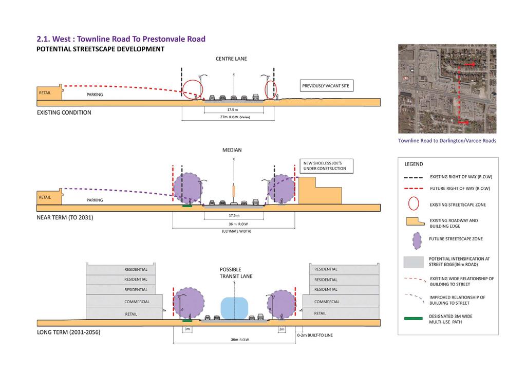
19 2.1. West : Townline Road to Prestonvale Road WEST Gateway/Commercial Precinct 7


20 2.1. West : Townline Road to Prestonvale Road Townline Road to Darlington/Varcoe Roads LAND USE AND BUILT FORM The intersection of Townline Road with Highway 2 is the commercial hub of Courtice. This area is defined as the Courtice West Shopping District Secondary Plan. Current uses are low intensity commercial plazas, but the policies permit mixed uses, increased densities and encourage new buildings to be located at the street edge. The Townline Centre retail plaza is the largest contiguous parcel in the commercial district, with significant frontage along both Highway 2 and Townline Road. The single storey plaza is set well back from the street, served by an expansive parking lot which is about a half storey lower than the street elevation. The building has raised glazed entrances and an arcade at the shopfronts. Retail tenants range from a mix of medium sized franchises such as Price Chopper, Bulk Barn and Quiznos to smaller, specialty shops such as Play it Again Sports and other personal service uses. Two gas stations occupy the eastern corner properties at Townline Road and Highway 2 and create the first impression of Clarington and Courtice. There is opportunity to utilize these sites for municipal or community signage. Consideration should be given to phase out automotive uses in the Study Area. Eastgate Plaza is a single storey plaza on a large, contiguous site. The building is set well back from the street edge with a surface parking in front. It has a mix of medium sized retailers and offices, such as Dairy Queen, Rogers, Pizza Nova and personal services such as a salon and optometrist. The buildings along the south side of Highway 2 continue eastward as a mix of single storey, newer and older multi-unit retail plazas, set back from the street with parking in front and along the sides. The south side of the commercial district consists of smaller, narrower properties which have evolved as separate plazas, occupied by a range of local businesses and corporate franchises. All buildings are set back from the street edge with customer parking at the front and some underutilized parking in the rear. This pattern creates an uncoordinated range of building forms, setbacks, building style and signage. Franchises include RBC, Home Hardware, Money Mart, Tim Hortons, Blockbuster Video and Subway. Local businesses include Barnaby s Restaurant and Lucinda s Salon and Spa. Tim Hortons, one of the recent developments, generates significant traffic in its front parking area and drive-through lanes. These buildings are occupied by established, local businesses providing community amenities, such as Durham Travel, East Oshawa Physiotherapy, Val s Bridal, Valeo Draperies, insurance, hair and cosmetic services. This photo is of the new Shoeless Joe s restaurant which is set closer to the street than the existing buildings and it locates its customer parking at the rear. 8


21 2.1.2 Darlington/Varcoe Roads to Prestonvale Road 2.1. West: Townline Road to Prestonvale Road LAND USE AND BUILT FORM The north east side of Varcoe Road and Highway 2 is occupied by Courtice Health Centre, a three storey medical building. The property shares parking and access with the adjacent White Cliffe Terrace Retirement Home, and has corner frontage and attractive streetscaping. The Courtyard Restaurant at the south-west corner of Darlington Boulevard and Highway 2 is set close to the street frontage, attractive landscaping and a patio at the street edge, creating an inviting presence at the intersection. The four storey White Cliffe Terrace Retirement Home shares its site with the medical building. Together, the buildings break the single storey arterial commercial format to the west. Tim Hortons is located in the intersection of Centrefield Drive with Highway 2. The sloping setting abutting Black Creek makes it an attractive, green site, with good sidewalk conditions. A large, vacant area that edges onto the Farewell Creek valleyland creates open frontage along south side of Highway 2. The property presents a good opportunity for high density development, with excellent views to the valley, access to Highway 2 and proximity to shopping in the Courtice West Shopping District. The Hilltop Restaurant is a well established Courtice locale, perched at the intersection of Farewell and Black Creek. The property s location makes it an excellent redevelopment site, but it has constraints because of its proximity to the natural lands and servicing issues. Once servicing infrastructure is in place, this property may have better opportunity to become a landmark development. 9


22 2.1. West: Townline Road to Prestonvale Road STREETSCAPE AND PEDESTRIAN CONTEXT/OBSERVATION The Townline Centre and Eastgate Plazas are quite active. Cars move quickly through the large parking areas and driveways. Pedestrian orientation across the parking areas is poor. Driveways from Highway 2 and Townline Road are wide, resulting in heavy vehicular turning. The intersection of Townline Road and Highway 2 is wide with many carsturning in all four directions. Pedestrian movement is difficult because of the pavement width and turning vehicles. The Courtice West Shopping District Secondary Plan provides for a system of internal lanes to provide continuous access between the properties. Currently the route is circuitous, and faces rear loading and garbage areas. Shoeless Joe s is one of the the last sites to complete the easement access. If the access is intended for customer use, its alignment and pedestrian amenity/access should be improved. This photo shows the current termination of the easement, which would eventually be connected to the rear of the Shoeless Joe s site. The side walk conditions along Highway 2 towards Prestonvale Road are in good condition, but the sidewalks are visually unappealing and inconsistent. One of the most attractive features of Highway 2 is the Courtice signage tucked into the Black Creek valley slope. This gateway signage could be enhanced by other complementary signage and landscaping in both travel directions. This long range view across the two valleys is Courtice s defining image. It could be significantly improved with formalized landscaping, distinctive light standards and banner poles. Old Kingston Road, a small curved street diverts into the Farewell Creek valley, providing access to one residential property. This segment presents an opportunity to enhance and celebrate the natural features of the two creeks and the history of Courtice. Streetscaping, signage and potentially, trail or pathway access into the valley could be explored. 10
23 11

24 2.1 West : Townline Road to Prestonvale Road OPPORTUNITIES - Municipal Gateway, signage opportunity at Townline Road. - North side plazas could redevelop as greyfield conversion to mixed use, intensified development; this would be long term. - Vacant site at Farewell Creek could be developed as high density signature site. - Special streetscaping can identify the Courtice Shopping District and Farewell Creek Valley view corridor. CONSTRAINTS - Multi unit plazas on the south side are established businesses; redevelopment in short term is unlikely. - Comprehensive redevelopment of south side will be limited by individual property ownership. CONCLUSIONS 1. Implement a streetscape and gateway program to improve image in short term. 2. Consider policies to encourage transition of north side to mixed use. 3. Encourage higher density development at Farewell Creek edge. 4. Implement special community streetscaping programme at the Creek Valley crossing. 5. Develop a Business Improvement Area (BIA) for the corridor which would provide some ownership of some of the streetscape features. 12 PRESTONVALE RD Excerpt of maps A and B from Section 8. South Side TOWNLINE RD Refer to Section 8 for full diagrams and legends. South side along Townline Road North Side

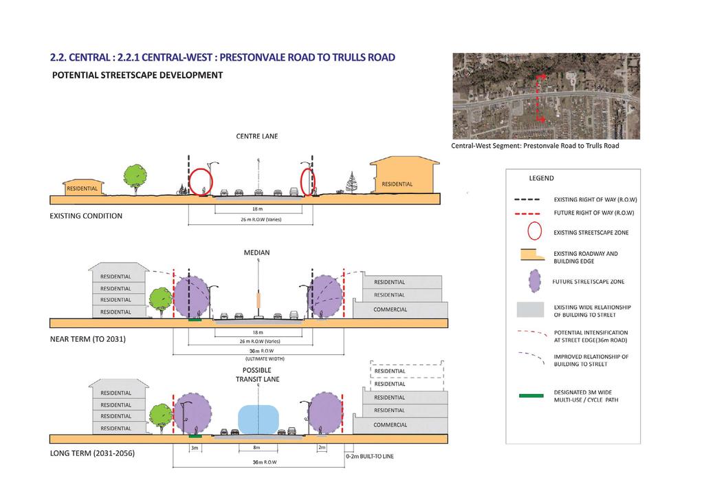
25 2.2.1 Central-West : Prestonvale Road to Trulls Road CENTRAL WEST Black Creek/Residential Precinct 13


26 2.2. Central : Central West Prestonvale Road to Trulls Road LAND USE AND BUILT FORM The segment from Prestonvale Road to Trulls Road is primarily residential in nature. It has a mix of established small single family dwellings, and some that have converted to business uses each with driveway access to Highway 2. As one drives along Highway 2, there is a lingering small town main street character in this area, as some of the properties are large and well kept. View of a series of adjacent small single residential properties along the north side. A large parcel of land occupied by Rogers interrupts the pattern of residential/business properties. It is a single storey office building set well back against the edge of the Black Creek. Some of the residential properties have converted to offices and other uses, which is evidence of transition from residential to commercial uses. The townhouses at the north end of the adjacent neighbourhood have flankage frontage along a window street parallel with Highway 2. Future development will need to create a transition to these properties. The south side of Highway 2 is mostly commercial with small businesses on narrow deep lots with individual driveway access to Highway 2. The Courtice Funeral Home at the intersection of Sandringham Drive and Highway 2, is an attractive institutional use at street edge with a high quality brick and stone building and well maintained landscaping. The Pine Ridge Motel along the south side of Highway 2 appears neglected. It is a large deep site with good redevelopment potential. 14


 has the potential to be an important")
27 2.2 Central: Central West: Prestonvale Road to Trulls Road STREETSCAPE AND PEDESTRIAN CONTEXT/OBSERVATION The north-west corner of Trulls Road and Highway 2 is a municipally-owned parcel of vacant land. It has the potential to become a small gateway parkette, as a passive green space. It could also provide future secondary access to the north side properties, to facilitate their redevelopment. The John Michaels Hair Studio & Barber Shop is one of the businesses in a converted dwelling. The front setback is a surface parking lot which creates a car-oriented street edge. Courtice Automotive adjoins the parking area with the Salon. Cars are parked at the parking lot edge at the sidewalk, separated by a concrete curb/barrier in some locations. There is little separation between the sidewalk and the cars. The sidewalk abuts uneven asphalt paving beside the parked cars, creating a generally unattractive pedestrian environment. The intersection of Trulls Road and Highway 2 (looking east towards the Town Centre Site) has the potential to be an important gateway into the Town Centre site. The window street and berm create a streetscape condition that does not occur anywhere else along Highway 2. New streetscaping should provide landscape screening to the flanking town homes. At the Pine Ridge Motel and adjacent properties, the sidewalk is in good condition, but visually unappealing and inconsistent. Sidewalk surface upgrades and coloured paving strips would be minimal improvements that could enhance the overall image. 15
28 16

29 TRULLS RD Excerpt of maps A and B from Section 8. North Side 2.2 Central : Central West :Prestonvale Road to Trulls Road 17 Refer to Section 8 for full diagrams and legends. OPPORTUNITIES - View corridor enhancement : Sweeping views of the valleylands can be enhanced with special streetscaping and signage. New trail links to the valleylands could become a recreational destination. - Small town image of Courtice can be retained with lower scale redevelopment. - Conversion to more commercial uses is already happening. - Corridor safety could be improved with the installation of a raised median with limited left turn opportunity. CONSTRAINTS - Properties are constrained by Black Creek along north side. - No alternative street / lane access for Highway 2 properties. - All properties remain on private sanitary services which will limit opportunity for redevelopment and intensification inthe short term. - Existing property sizes are too small for higher density developmentland assembly is required. CONCLUSIONS 1. Implement raised median for traffic measures and streetscaping (banners, lighting) 2. Implement a special Community Streetscape programme at the Creek Valley crossing. 3. Prioritize provision of municipal servicing to catalyze redevelopment and support intensification. 4. Implement shared local street /lane network to provide access for new development. 5. Establish minimum property areas to achieve desired level of intensification. South Side PRESTONVALE RD

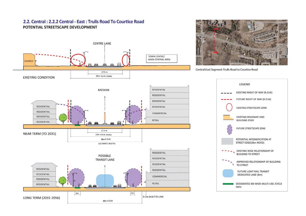
30 2.2.2 Central-East : Trulls Road to Courtice Road CENTRAL EAST Town Centre Precinct 18


31 2.2 Central: Central-East : Trulls Road to Courtice Road LAND USE AND BUILT FORM This segment is divided into two distinct areas: The Courtice Town Centre site, between Trulls Road and the future Maplefield Drive, and a group of individual properties between the Town Centre site and Courtice Road. The existing homes along the west side of Trulls are a series of townhouse blocks that edge onto an established low density neighbourhood. The Courtice Town Centre site comprises 13 hectares of mostly vacant land, with 330m of frontage along the south side of Highway 2 and 500m of frontage along the east side of Trulls Road. These two businesses, Clarington Stove Centre and Permanent Pool and Patio are located in a converted dwelling. The corner property forms part of a possible gateway location to the new Town Centre site and has the potential to transform into a designed view corridor. This panorama of the properties opposite the Town Centre site illustrates both their potential for intensification on mostly vacant land, but also shows the constraints of the proximity to the Black Creek valley edge. There will most likely be significant erosion setbacks and servicing issues, which will limit its potential for increased density. This view looks into the future Town Centre site. The lands are currently vacant and present a good opportunity to create a vibrant mixed-use area with a commercial focus. Current policies permit a mix of land uses and range of densities. This property is one of several single family dwellings along Highway 2. Some properties are in better condition than others, signaling a transition from single family to other uses. The Roy Nichols Motor Ltd. GM Dealership occupies a large, contiguous property at the south west corner of Highway 2 and Courtice Road. The size and corner orientation of the site presents an excellent redevelopment/ intensification opportunity. 19


32 2.2 Central: Central-East : Trulls Road to Courtice Road STREETSCAPE AND PEDESTRIAN CONTEXT/OBSERVATION The north side of Highway 2, from the Town Centre site to east of Courtice Road is occupied by Black Creek. This natural, green frontage is one of Courtice s most defining characteristics, providing a natural streetscape into the community. The attractive Nantucket townhome neighbourhood is visible behind the Creek. The intersection of Trulls Road and Highway 2 represent the focal intersection of the new Town Centre site. This corner should be developed with a highly designed pedestrian and landscaped corner gateway. This single dwelling presents an opportunity for redevelopment to higher density, as part of an assembly with adjacent properties. New comprehensive streetscape and sidewalk improvements should occur with redevelopment of this frontage from the Town Centre to Courtice Road. The intersection of Courtice Road with Highway 2 is the most important intersection of this segment. As the potential eastern gateway to the Courtice Main Street C orridor. The sidewalk is in good condition but visually unappealing and inconsistent and cars from the Roy Nichols Motor Ltd. Dealership edge directly onto the sidewalk. New streetscaping and gateway signage could be implemented in the short term. 20
33 21

34 Excerpt of maps A and B from Section Central : Central East : Trulls Road to Courtice Road Refer to Section 8 for full diagrams and legends. OPPORTUNITIES - Town Centre site has potential to develop as Courtice core. - Current land uses at Courtice Road provide good base for mixed use development. - Improving corridor safety with the installation of a raised median with limited left turn opportunity. CONSTRAINTS - Properties constrained by Black Creek along north side resulting in single sided development of Town Centre site. - All properties are currently on private sanitary services. CONCLUSIONS 1. Implement raised median for traffic measures and streetscaping (banners, lighting) 2. Prioritize provision of municipal servicing to catalyze redevelopment and support intensification. 2. Implement shared local street /lane network to provide access for new development. 4. Require minimum property area for redevelopment. 22 COURTICE RD View of the South Side at future Maplefield Drive View of the South Side along Highway 2 next to Roy Nichols GM Auto dealership TRULLS RD

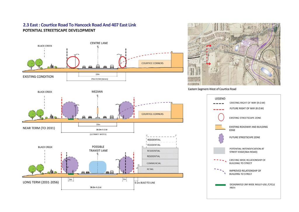
35 2.3. East : Courtice Road to Hancock Road and the 407 East Link EAST Courtice Transit Gateway Precinct 23


 for the 407 East Link, a Transitway, Commuter Parking Area / Transitway Station")

36 2.3 East : Courtice Road To Hancock Road and The 407 East Link LAND USE AND BUILT FORM This segment of the Study Area consists of dispersed commercial and residential uses in a predominantly rural setting. The eastern edge of the Study Area presents long term development opportunities. ROPA 128 has designated Courtice Road as a Regional Corridor and, with the proposed 407 East Link interchange and Transitway, this area has the potential for increased densities and mixed land uses to support transit use. There is a pocket of single family dwellings along the north side adjacent to the agricultural land. They are isolated properties, with the Black Creek frontage on the western side and the proposed Transitway on the east. They have the potential to transition to commercial uses. Agricultural lands to the east of this residential property have been purchased by The Ministry of Transportation (MTO) for the 407 East Link, a Transitway, Commuter Parking Area / Transitway Station and bypass to Hancock Road. The Courtice Corners Retail Centre is a large land parcel which could redevelop as a compact mixed use, higher density development in the long term. From the Courtice Corners Retail Centre easterly to the proposed 407 East Link, the lands on the south side of Highway 2 are currently agricultural but designated as Future Living Area in ROPA128. Because of the availability of other lands for intensification, these lands may develop in the very long term. However, because of their proximity to future transit, and their location on a Regional Corridor, they should be designated for at the minimum, mixed use, medium density. Provision of a rear system of local street/lane access will be necessary for their development. 24

37 2.3 East Segment-courtice Road To Hancock Road And The 407 East Link STREETSCAPE AND PEDESTRIAN CONTEXT/OBSERVATION There is no streetscape activity along this stretch of rural property. The residences have driveway access and there is no sidewalk. Streetscape improvements will occur at the time of redevelopment of these lands for the proposed 407 East Link Transitway. The Courtice Corners Retail Centre sets a good precedent for a well developed streetscape. The plaza s street edge is well landscaped with good pedestrian connections to the sidewalk and bus stop. These connections could be improved further with a Courtice gateway treatment, pedestrian scaled lighting and bicycle lock-up areas, to encouraged walking to the plaza from neighbouring residential areas and schools. 25
38 26

39 South side looking East 2.3 East : Courtice Road to 407 East Link OPPORTUNITIES - Potential for higher densities to support transit infrastructure. - Courtice Corners Plaza provides good commercial amenity to future development. - Potential Gateway development at intersection of Highway 2 and Courtice Road. - Improving corridor safety with the installation of a raised median with limited left turn opportunity. CONSTRAINTS - Future land uses adjacent to new Hancock Road ramp/by-pass will require careful interface. - Existing residential properties are isolated. - Part of the area is outside current urban boundary pending. (Provincial approval) CONCLUSIONS 1. Implement raised median for traffic measures and streetscaping (banners, lighting) 2. Design for transit-oriented development with possibility for nonresidential development at Hancock Road by-pass. 3. Designate existing residential properties as commercial to serve Transitway; a connection across the proposed storm water management (SWM) will be required. 4. Develop intersection as a distinctive Courtice arrival gateway, with Black Creek as a natural backdrop. Plan for intensification at the intersection of Highway 2 and Courtice Road, the two Regional Corridors EAST LINK Excerpt of maps A and B from Section 8. COURTICE RD Refer to Section 8 for full diagrams and legends.


40 3.0 PUBLIC WORKSHOP 3.1. Process The first of two public workshop and information sessions for this Study was a Community Vision Workshop, held on July 22, 2009, from 7:00 to 9:00 p.m. The purpose of this meeting was to introduce the Study to the Courtice business and property owners and residents, discuss issues and characteristics of the Study Area and identify some preliminary goals or vision for development of future built form and streetscape improvement. The goal of the session was to establish a Vision Statement, as a foundation for establishing the Study s planning and urban design principles. The Workshop was attended by approximately 60 residents, property and business owners. The evening was structured in two parts: the consultant presented the key issues of the Study which was followed by a question/answer period. The second hour of the evening was devoted to group work. The attendees worked at eight tables of six to ten participants and responded to a few simple questions presented by the consultant. Each table was provided with an aerial photo of the Study Area and some images of mixed use residential and streetscape development for discussion. Below are the questions and highlights of the ensuing discussions. Group working sessions 3.2. Session 1 Identify some Positive Attributes of the Highway 2 Corridor. Participants cited that the Corridor has an important function as Clarington s primary east-west link, providing convenient vehicular access to Oshawa and Bowmanville. It was seen as having limited community character but that there is a great potential for both business development and community involvement to improve the area and its image. Many groups cited the presence of the Farewell and Black Creek Valleys as the area s most noticeable, beautiful and unique features. These green areas were seen as places to be emphasized, better utilized and integrated with future development. Some sample comments were: Not much has been done; it is a clean slate for improvement. There is opportunity for working together. The two Valleys are beautiful and unique and could be utilized better for pedestrians and cyclists. View of Farewell Creek 28


41 Indentify some Challenges and Issues of the Highway 2 Corridor. A variety of functional issues were identified as the main challenges and negative issues, ranging from snow clearance to lack of street trees. Almost each group cited snow clearance as a major obstacle for private property maintenance and access to Highway 2 from individual driveways. Snow is ploughed onto sidewalks, blocks driveway access and causes difficulties for pedestrians, drivers and property owners. Some residents are physically unable to clear the snow. The lack of sanitary services was clearly a sensitive point for the community. Participants stressed that this condition gives Courtice a poor image in the context of other Clarington communities. Many stressed that development is not likely to occur as long as properties remained in private services. It was also noted that some properties are now vacant with no apparent plans for redevelopment. There was a perceived increase in vandalism and crime which participants felt directly resulted from the deterioration of these properties. Another one of the most noted issues was Highway 2 s high traffic speeds and volume, which participants felt resulted in noise, dirt and a route that is neither accessible nor comfortable to pedestrians and cyclists. Traffic in the Courtice West Shopping District was noted as congested and transit service was also noted as insufficient. Other negative characteristics of the Corridor were that it had no distinct community image; there was no central commercial area; there were not enough street trees and gathering spaces; and, there was a perceived lack of commitment for maintenance of landscaping along the street edge. Some sample comments were: Views of less desirable qualities of the Corridor Invest in services for the Corridor development won t happen without full services. Courtice residents feel like the second class citizens of Clarington (no sanitary services). It has no character or Courtice image; Courtice is a bedroom community. Street trees and landscaping should only happen if there is a commitment to maintaining them. There is no centralized business area and no central gathering space. Traffic and lack of identity 29

42 What is Courtice s Role in Relation to Oshawa and Bowmanville? The resounding sentiment to this question was that Highway 2 is important, as it is the only major link between Oshawa and Bowmanville. Although convenient, residents felt the area has little connection to either Oshawa or Bowmanville. They expressed that it should be more defined as a distinct community. Again, the perception that Courtice has a poor image in Clarington was voiced. Some sample comments were: Courtice is the poor cousin of Clarington. Courtice should be a Gateway between Oshawa and Bowmanville. Highway 2 as the main link across Clarington 3.3. Session 2 Identify qualities to be improved and some goals or a Vision for development. Investment in sanitary services was registered as the primary need for improvement. New streetscaping that enhanced the presence of the Valleys and creation of a gathering space were also important. Other issues included creating a commercial hub, promoting small business and increasing densities and mixed uses. Some sample comments included: Create a central gathering space with a smaller scale villagelike or historical character for independent businesses and residents to enjoy; the historical intersection should be the hub of Courtice. Improve the edges of the corridor well-designed sidewalks, landscaping and lighting are a must to improve safety and civic pride. Create a realistic and achievable plan! Envision Courtice as A Breath of Fresh Air between Oshawa and Bowmanville. Be bold about encouraging higher density and mixed use but not too high! An example of built form in Markham, Ontario, that was seen as too high and massive for Courtice 30


 mixed use buildings, with retail at grade and office or residential above were the preferred")

43 What are examples of desirable buildings and streetscaping? For this question, participants were provided two pages of photographs of higher density residential buildings, from townhouses to 8 and 12 storey buildings (in Markham); images of new commercial uses along an arterial highway condition; and, some landscaping and public spaces. Participants were asked to identify which images they liked or disliked. Some groups numbered the images on stickers provided and put the stickers that corresponded with the photographs on the aerial photograph. Preference for Residential Built Form: Low rise (three to five storeys) mixed use buildings, with retail at grade and office or residential above were the preferred types of buildings. Some groups envisioned higher buildings (six to eight storeys) on select sites (e.g. at Darlington Blvd overlooking Farewell Creek and at Trulls Road). Other groups envisioned townhouses along the Black Creek edge and west of Courtice Road towards Hancock Road. Non Residential Uses: A mix of retail and office uses was envisioned at Trulls Road; denser development closer to Townline Road and lower densities further east. There was a definite need for a public open space, with seating, shade and landscaping that is connected to shopping and transit amenities. Examples of preferred development forms 31

44 4.0 PLANNING POLICY CONTEXT There is a range of planning policy - from Provincial to Municipal that mandates that intensification should be directed to urban areas and utilize existing infrastructure. The application of these various levels of planning policy to the Study is summarized in this Section Provincial Policies Provincial Policy Statement (PPS) and Places to Grow The PPS In 2005 the Provincial government issued a new Provincial Policy Statement (known as the PPS) which includes recommendations for residential intensification as a means of meeting long term housing demand. The PPS states that municipalities shall promote opportunities for intensification and redevelopment that respond to the local context of existing buildings and the availability of suitable existing or planned infrastructure and that they should build on these objectives through the Official Plan Process (Section ). Places to Grow - The Growth Plan Shortly following the PPS, the Province issued Places to Grow or The Growth Plan for the Greater Golden Horseshoe (2006). This document provides more detailed policies for managing growth and revitalization of existing urban areas to ensure that existing and new development grows as balanced, complete and compact communities. Similar to the PPS, The Growth Plan municipalities to concentrate growth through: the intensification of the existing built-up areas, with a focus on urban growth centres, intensification corridors, major transit station areas, brownfield sites and greyfields. (Section 2.1) These broad policy directives are directly relevant to the Study Area: it is Courtice s business and community core, which has the potential to become a more vibrant area and focused area for intensification; it is located along a major transportation route that provides a vital link between Oshawa and the rest of Clarington; and, there are significant transportation route and infrastructure initiatives planned for the area. 32

.")
45 As a component of the Official Plan Review and creation of a Secondary Plan, this Study will contribute to determining how Courtice can be developed as an important element of Clarington s commitment to reinforcing communities and encouraging compact growth and development to support the Provincial goals Metrolinx Draft Regional Transportation Plan In 2006, after a review of the transportation infrastructure of the Greater Toronto and Hamilton Area (GTHA), the Province created Metrolinx (formally known as Greater Toronto Transportation Authority). The result of the review was that the current GTHA network of transportation corridors is inadequate, both in terms of physical capacity and implementation, and a new strategy to develop and implement an integrated multi-modal transportation plan for the GTHA was necessary. Metrolinx s resulting Draft Regional Transportation Plan (RTP) identifies the required infrastructure (roads, rail, subways and bridges); changes in travel needs and behaviour; and, sustainable implementation and funding to achieve the strategy over the next twenty-five years. Fig 4.1 Excerpt from Metrolinx Draft Regional Transportation Plan mapping 33

46 The Draft RTP has identified some priority routes and infrastructure in the near term (4 15 year horizon) in Durham Region: Rapid transit service along Highway 2 in Durham Region Improvements to existing GO Rail services and extension of GO Rail service to Bowmanville which includes a potential GO Station in south Courtice; and, A transportation Corridor to be implemented with the results of Environmental Assessment (EA) studies The 407 East Link Preliminary studies for all of these initiatives are currently underway. As part of the extension of transit and GO Rail services, Durham Region Transit is undertaking a Long Term Transit Strategy and a Transit Oriented Design Strategy. These studies are investigating the location of a Courtice South GO Station on the west side of Courtice Road, along the north side of the existing CPR track, and future improvements to transit service along Highway 2 are anticipated, subject to further studies. As part of the transportation Corridor Class EA study for the 407 East Link, preliminary technical designs include a dedicated rapid transit/transitway along the west side of the highway corridor which will provide a transit link between the proposed Courtice South GO Station and Highway 2. The result of these multi-level, coordinated initiatives will be a future convenient, interconnected transit network for Courtice, which demands that Courtice must plan for more intense land use and compact built form to support the viability of these commitments. STUDY AREA 4.2. Regional Policies Durham Regional Official Plan The Durham Regional Official Plan (ROP) (consolidation 2008) establishes fundamental goals, objectives and policies for all land uses in the Region, based on goals and an urban structure pattern that is intended to preserve farmland and natural areas, define employment areas and create distinct community focal areas with a balanced pattern of residential, commercial and mixed use development. Courtice figures prominently in the ROP in both broad planning objectives and detailed policies. Specifically, Section Regional Structure Policies identifies the Whitby/Oshawa/Courtice Urban Area as the focal point of the Region. The subsequent Regional Structure policies establish land use and intensification patterns for the Regional Urban Areas which directs growth towards areas called Centres and Corridors. Fig 4.2 Courtice Area - Schedule A- Map A5, ROP
 and therefore, these areas are logical areas for intensification.")
47 This pattern recognizes that the proposed 407 East Link transportation corridor will have an impact on adjacent communities, that is, that they will experience growth over time (Section 7.3.4) and therefore, these areas are logical areas for intensification. The Courtice Main Street Study Area is one of these focal areas that include both a Regional Centre and Regional Corridor: the Town Centre Site is a Regional Centre and Highway 2 is a Regional Corridor. The ROP requires that as part of their Official Plan processes, municipalities shall include detailed policies or a Secondary Plan to guide the development in these areas. As such, these designations and their policies are fundamental to the development of the Courtice Main Street Secondary Plan. CENTRES Regional Centres are defined as areas that should accommodate the main concentration of commercial, residential, cultural and governmental functions in a well design and intensive land use. (Section 8.A. 1.1). Regional Centres are to be designed as focal areas with a mix of uses, pedestrian oriented, high quality urban form and architectural design with a diversity of compact, higher density housing forms (Section 8A. 1.2.) CORRIDORS Regional Corridors form the key connections between the Centres and are considered the main arteries of the Region s urban structure. (Section 8A.1.4). Similar to Regional Centres, the policies for the development of Corridors require mixed use development at higher densities, transit supportive design and mixed uses that integrate with existing development (Section 8A. 1.5.) Growing Durham After the release of the Growth Plan in 2006, the Region initiated a Growth Plan Implementation Study - Growing Durham, to bring the Regional Official Plan into conformity with the Growth Plan policies. The Study makes recommendations to address population and employment forecasts to 2031, intensification and Greenfield targets and the resulting urban land needs up to that time frame. The analyses formed the basis for the development of alternative growth scenarios and a recommended preferred growth option for Durham which resulted in a set of key planning policy amendments to the ROP. 35
, which incorporated recommendations from the aforementioned Growing Durham Study. The Region has submitted ROPA 128 to the Province for review.")

48 4.2.3 Regional Official Plan Amendment 128 On June 3rd, 2009, Durham Regional Council approved the Durham Regional Official Plan Amendment No. 128 (ROPA 128), which incorporated recommendations from the aforementioned Growing Durham Study. The Region has submitted ROPA 128 to the Province for review. At the time of writing January 2010, the Province has not yet approved ROPA 128. ROPA 128 contains a number of policies regarding density, land use and built form that modify the previous ROP policies for Regional Centres and Corridors by prescribing specific densities and built form recommendations for these areas to meet the Region s anticipated population growth and preferred urban structure. The ROPA128 policies that augment the 2008 ROP Centres and Corridor policies are: CENTRES Regional Centres should support an overall, longterm density target of 75 residential units per gross hectare and a floor space index (FSI) of 2.5, within the Lake Ontario Shoreline Urban Areas. The built form should be an appropriate mix of high-rise and mid-rise development, as determined by municipalities. (Policy 8A2.2(b)(ii)) CORRIDORS Portions of Regional Corridors with an underlying Living Area designation should support an overall, long term density target of 60 residential units per gross hectare and a floor space index (FSI) of 2.5. The built form should be a wide variety of building forms, generally mid-rise in height, with some higher buildings, as detailed in municipal official plans. (Policy 8A2.9) (Please refer to Appendix 1 for a discussion of density and FSI.) In consideration of the planned 407 East Link, ROPA 128 also recommends expansion to Courtice s Urban Boundary to the 407 East Link, and designates Courtice Road as an additional Regional Corridor. Courtice Road intersects with Highway 2; the future intersection treatment and the type of built form at the Courtice Road / Highway 2 intersection should be of a higher order to mark its linkage and higher density Corridor designation. Fig 4.3 Courtice Area - Schedule A- Map A5, ROPA

49 4.3. Municipal Policies Clarington Official Plan (January 2007 Office Consolidation) As mentioned earlier, the Study Area spans the entire width of the Courtice Urban Area along Highway 2. There are five primary Official Plan land use designations within the Study Area: Courtice West Shopping District Secondary Plan Urban Residential Medium and High Density Special Study Area 1 - Town Centre Special Policy Areas F and E Environmental Protection (Farewell and Black Creeks) Each of these designations reflects current land uses, built form patterns and recognizes the potential constraints of existing property ownerships and land use activities. The urban design and built form policies of each designation also promote further intensification and the transition of site planning and built form to more street-related and pedestrian oriented and transit-supportive design. However, there is no single vision for a comprehensive and integrated development of the length of the Corridor. Fig 4.4 Excerpt from Land Use - Courtice Urban Area Map A2, Clarington Official Plan 37
 provides development policy for the area from Townline Road to the east side of Varcoe")

50 Courtice West Shopping District Secondary Plan The Courtice West Shopping District Secondary Plan (CWSDP) provides development policy for the area from Townline Road to the east side of Varcoe Road/Darlington Blvd. The area is defined as the western gateway to Clarington and the municipality s interface with Oshawa, and is to be developed as a focal point of activity. The land uses include General Commercial, Office Commercial and Mixed Use designations each with their respective built form policies. In general, The CWSDP reflects the current Provincial and Regional planning goals for mixed-uses, high quality urban design and pedestrian and transit-supportive development. Policies support redevelopment of the area with more compact form (4 6 storeys), mixed uses, bringing buildings to the street edge, higher quality of public realm, and propose a solution of access issues through the implementation of internal lanes. For this Study, the redevelopment and intensification of the area s current mix of strip plazas, vacant lands and single dwellings is anticipated to occur over the very long term. In the interim, the area will remain as Courtice s business and commercial hub and would benefit from a simplification of land uses and implementation of a gateway and streetscape programme. Fig 4.5 Land Use Map A, Courtice West Shopping District Secondary Plan Urban Residential - Medium and High Density This designation is predominantly for housing purposes with some ancillary uses such as corner stores and home-based occupations and mixed use development. Medium Density is defined as units/net hectare, in built form ranging from townhouses to mixed use developments up to 4 storeys. High Density is defined as units/net hectare, in built form ranging from medium rise apartments to mixed use developments, up to 6 storeys. Views of Shopping District Courtice West Shopping District from sidewalk 38
 at the south east quadrant of Highway 2 and Trulls Road. The area has significant vacant frontage along both roadways and abuts low density, single family neighbourhoods.")
51 Special Study Area 1 - Town Centre Section Courtice Main Central Area Special Study Area 1 delineates the Courtice Town Centre (termed the Main Central Area in Section 17.2) at the south east quadrant of Highway 2 and Trulls Road. The area has significant vacant frontage along both roadways and abuts low density, single family neighbourhoods. It is to be developed in a Secondary Plan as the centre of commercial, cultural and community activity with a fully integrated array of land uses. (Section 17.2) In conformance with ROPA 128 policy, this area is Courtice s Regional Centre and if ROPA 128 is approved it will require a density of 75 persons/gross hectare and an FSI of 2.5. The policies under Section 17.2 permit the development of a 6.4 hectare parcel of land at the south-east corner of Highway 2 and Trulls Road to be developed with up to 13,900 sq.m. (150,000 s.f) of commercial retail space. Aerial view of Town Centre Site The policies for this area will be consolidated in the new secondary plan of this Study and will reflect the higher densities, built form and land use mix of the Regional requirements. Specific boundary delineations, such as the 6.4 hectare commercial area may be modified through this process. Section Town and Village Centres This section provides additional, more detailed policies for the municipality s Town Centre designation: Maximum Gross Leasable Floor Space for Retail and Service Uses: 30,000 sq.m. Maximum Floor Space Index (FSI): 1.5 on a net development parcel Residential and/or mixed use developments to achieve higher densities, a diverse land use mix with complimentary functions Planned on a grid system of streets and walkways to support pedestrian and transit supportive environments Active streetscapes and creation of a pedestrian, human scale environment as a paramount priority for the planning of buildings and public spaces; and, Mitigation of the views of parking areas through provision of street related built form and siting of parking areas to the rear. View of the Town Centre Site, Looking south-west This Study will seek to consolidate the range of density and built form policies of ROPA 128, simplified Official Plan designations and urban design policy. 39


52 Special Policy Areas E and F Section 16.7 Area E Redevelopment Districts These areas are lands defined as being occupied by long-established commercial or industrial uses. The designation recognizes that there may be land-use conflicts with adjacent residential uses and the policy encourages the relocation of these uses to other designated Employment Areas or Highway Commercial Districts. However, the designation also recognizes that established businesses, these uses may bring economic benefits to the area and therefore supports and encourages the improvement of such operations, if they are to remain. Special Policy Area E is occupied by the Roy Nichols Motors Ltd. GM Dealership. As an auto-oriented use, it is generally seen as incompatible with residential intensification, mixed use higher density development and pedestrian oriented design. However, this is an established, local business which contributes to the community s identity and commercial vitality. The Study will determine a long-term land use, density and desired built form that may be triggered by sale or redevelopment of the property, should it occur. Further consultation with the owner is required. In the short term, improved streetscape conditions and possible gateway development at the intersection would further enhance the image of this high visibility site. Section 16.8 Area F King Street Corridor These lands are predominantly existing residential dwellings on larger lots with individual driveway access to Highway 2. With this Special Policy Area, the municipality has set in place the intent to transition these dwellings and individual properties to higher density uses to create a transit supportive environment along Highway 2, which is designated as a Regional Transit Spine. Permitted uses are medium and high density residential uses with some office uses, recreation, community and institutional uses. The policies are supportive of intensification and diversity of land use. Aerial view of Special Policy Area E. View of the Roy Nichols Motors Ltd. GM Dealership from Courtice Road. Example of a single family dwelling along Highway 2 Because of individual ownership, lack of sanitary servicing (which will be discussed later in this report) and access restrictions, redevelopment would be longer term, yet foreseeable, with future infrastructure investment and introduction of rapid transit along the Highway. Many of these properties have already been converted to business, or a mix of business/ dwellings. 40

53 4.3.2 Zoning By-Law There are three primary zoning categories in the Courtice Main Street Study Area: Environmental Protection, Residential and Commercial. The residential and commercial designations fall into several sub-zones with multiple amendments related to site specific developments that have occurred over time. In total, the Study Area encompasses 25 sub designations. Fig 4.6 Current zoning allocations: Green= Environmental Protection, Pink=Commercial; and, Yellow=Residential Residential Residential zones (yellow areas) extend along the entire corridor except for the Courtice West Shopping District. Permits low density development including single family and semi-detached housing. Site specific zoning amendments to permit townhouse development, seniors housing (White Cliffe Terrace) and other non-residential uses (funeral home, real estate office). Building heights are low-rise with an average height of 10.5m (3 storeys) 41


54 Commercial The predominant commercial zone is the Courtice West Shopping District with sporadic commercial uses across the Study Area and a small cluster at Courtice Road, at the Roy Nichols Motors Ltd. GM Dealership and the Courtice Corners Retail Plaza. Permits mixed use development (buildings with commercial ground floor and residential floors on top) including all nonindustrial commercial uses. Average permitted coverage of 75% is high, indicating the potential for intensification in commercial zones. Average building height limit is 3-4 storeys. The Study Area s current zoning format and site specific content point to the need for simplified and flexible ready-to-go zoning. Pre-zoned areas that permit a wider mix of uses would facilitate a quicker development / approvals period and may be an incentive for redevelopment. New policy must be careful to set in place and protect for the desired land use, density and built form relationships that support longer term intensification goals. 4.4 Form Based Codes and the The Transect As part of the Official Plan review, the Municipality has reviewed the potential for improving Clarington s urban design, built form and public realm. Two planning models, Form-Based Zoning and The Transect, have been identified to assist in re-crafting the current zoning by-law from either a one-size-fits-all or site specific, to a more designoriented format that conveys a better image of a desired built form that is sensitive to adjacent buildings and public areas. The following definition is summarized from the American Form-Based Codes Insitute: Through the use of diagrams and words as opposed abstract parameters of FAR,(floor-area-ratio) densities and parking ratios etc. form-based codes address the relationship between building facades and the public realm, the form and mass of buildings in relation to one another, and the scale and types of streets and blocks. They relate to an Regulating plan or master plan that provides the overall designations of built form and scale, not only land use. In contrast to guidelines, Form-based codes are regulatory, not advisory. Fig 4.7 Examples of Form-based zoning to describe the relationship of buildings to property edges and adjacent land uses 42
.")
55 The Transect The Transect is a simple model used by new urbanist planners in the United States to assist in creating development standards that are sensitive to context and convey an image of desired built form. The Transect is essentially a master plan that identifies zones or distinct areas of different character (referred to in new urbanist theory as tiers ). The different zones identify certain characteristics of streets and buildings that categorize the main function and physical environment of that area, and the desired transition between zones. This regulating plan or master plan sets the structure that the more detailed Form-based codes, mentioned above, will describe through diagrams and text. Fig 4.8 The Urban - Rural Transect, Duany Plater Zyberk & Company Relevance of The Transect and Form-Based Codes The resulting Master Development Plan of this Study will be, in essence, the regulating plan. The concept of The Transect is useful in that it suggests that a linear area is composed of segments that need transition between them. As illustrated in Section 2.0, the Highway 2 Corridor is naturally divided into distinct segments. As the Corridor will most likely develop with a mix of commercial and residential uses, at a range of densities and scales, the differences in strict land use will be subtle. The type and character of the buildings and streets will be the defining characteristics. Therefore, The Transect and Form-based Codes are planning mechanisms that can help structure the definition of the Corridor s distinct areas and convey the desired form of their development. The resulting secondary plan will be a Master Development Plan described by description and illustration of the type of desired built form that will be easier to use by both applicants and officials. 43

. The study was never adopted because of some stakeholder objections.")
56 4.5. Highway to Mainstreet : Courtice Highway 2 Corridor and Main Central Area Study Completed in 2001 by Markson Borooah Hodgson Architects and a multi-disciplinary consulting team, this study proposed a land use plan, policy and guidelines for the segment of Highway 2 between Prestonvale Road and Courtice Road, including the Main Central Area. For this limited area of Highway 2, the study presented a comprehensive streetscape and public realm program for this limited area of Highway 2 and detailed land uses, street pattern, built form, open spaces and the pedestrian system for the Main Central Area (Town Centre site). The study was never adopted because of some stakeholder objections. However, the main principles of improved public realm, compact form, an interconnected street network, mixed uses and creating a community focal area remain valid. This current Courtice Main Street Study will build upon these principles, where they prove appropriate to the site specific conditions. Fig 4.9 Proposed Land Use - Schedule A, Highway to Mainstreet Fig 4.10 Proposed Streetscape, Fig 31, Highway to Mainstreet 44
57 5.0 INTENSIFICATION, GROWTH MANAGEMENT AND IMPLICATIONS FOR COURTICE As discussed in the first section of this report, this study is concurrent with the Growth Management and Intensification Strategy components of the Official Plan Review. Centres and Corridors are key policy elements of the Growth Management and Intensification analyses and strategies. 5.1 Interrelationship of Project Components The Intensification Study component of the Official Plan review will determine how much land within the built-up areas of Courtice, Bowmanville and Newcastle can accommodate intensification. In general, this definition of intensification means the filling in, or development, of existing vacant lands. The Study will also propose a strategy for achieving higher densities along the key policy areas of Centres and Corridors. In some cases, these areas have of underutilized existing land uses and low intensity built form that have the potential to transform to more intense uses and development formats. The Courtice Main Street Study Area is one such environment and to that end, how the Courtice Main Street Study can respond to the ROPA 128 intensification objectives for Centres and Corridors will act as a test and possibly a template for a Centres and Corridors intensification strategy for Clarington. The Growth Management Study (GMS) component of the Official Plan Review determines the capacity of each of the three urban areas to accommodate Places to Grow, Growing Durham, ROPA 128 and Clarington Council s Corporative Strategic Plan to tackle some of the challenges facing growth. The Municipality s GMS examines how, when and where growth should occur by testing and distributing the Growing Durham population and employment forecasts to the local urban communities. The outcome of GMS will have significant fiscal implications for the Municipality and influence the provision of services and local infrastructure. The GMS will be the basis for updating Clarington s Official Plan to conform to Places to Grow and Growing Durham. The Courtice Main Street Study s proposal for future development and the appropriate amount of intensification will directly influence the allocation and timing of growth across the municipality. 45
58 5.2 Implications of the Analyses on Courtice The preliminary Housing Projection analysis for Courtice has identified a projected housing demand to 2031 of 4,010 units. Preliminary analyses of lands available for development indicate that, there are sufficient other Greenfield and vacant lands that, if developed, will fulfill both the Provincial intensification requirements and Courtice s projected population demand. This means that Courtice has sufficient available lands to meet this housing demand, without taking into consideration any intensification that could occur within the Courtice Main Street Study Area This begs the question: Why intensify Courtice Main Street? The answer is twofold: the Region s urban structure of Centres and Corridors recognizes the importance of the Study Area for Durham and Clarington to achieve intensification and managed growth; and, the Courtice community is ready for improvement and change. Intensification of Courtice Main Street is a strategic component to respond to higher level policies, create an integrated growth pattern for Clarington and galvanize the local community s civic pride Preliminary Intensification Scenarios Applying ROPA 128 Recommendations to the Study Area If the Courtice Main Street Study Area does not need to fully intensify in order for the Courtice Urban Area to fulfil its housing demand, to 2031, then one scenario for the Study Area to remain on its current development pattern is changing slowly with intermittent residential and commercial development. However, ROPA 128 requires specific densities and built form for Regional Centres and Corridors over time. Continuing with current development patterns will not be sufficient to meet these policies, nor is it acceptable planning to permit unplanned, low density development in existing community area. The diagram on the following page illustrates the application of the ROPA 128 densities to the Study Area: The pink areas represent 60 units/gross hectare (Corridors) along a 45m strip on both sides of the Highway, excluding the Highway 2 right of way and environmental areas. This yields 2,520 units. The blue area represents 75 units/gross hectare (Centres) to the Town Centre site. This yields 1,157 units. 46

59 Fig 5.1 Application of ROPA 128 densities to the Study Area If Highway 2 and the Town Centre were to be developed at the ROPA 128 recommended densities, the Study Area would accomodate 3,677 residential units. The definitions of density used in ROPA 128 describe that the distribution of density should be applied to 45% of an overall or gross site area (refer to Appendix 1 for further explanation). The implication of allocating development on less than half of the overall land area means that building heights would need to increase, possibly in the range of ten storeys, in order to meet the recommended densities. For comparison, as illustrated in the Growth Management Discussion Paper, areas of recent intensification in established urban centres are similar to ROPA 128 s density recommendations. For example, Toronto s Yonge/Eglinton area has a gross density of 84 units/gross hectare and North York Centre at Yonge/Sheppard has a gross density of 52 units/gross hectare. These gross densities are significantly higher than Clarington s recent new medium density development. However, these densities are broadly defined, a clear and simple tool needed to describe density across the entire Region. The structure of Centres and Corridors of ROPA 128 provides a logical based for a long term intensification and development strategy, and it is also reasonable that each condition needs to be refined to local conditions. Determining the right fit of density at the municipal level is essentially the role of this Study, not planning by numbers. Understanding the definition of ROPA 128 sets the benchmark but is not the solution. 47


 high rise buildings.")

60 5.3.2 Recent Development Trends in Clarington The ROPA 128 density and built form recommendations would represent a significant change in overall appearance of the Study Area. Some recent site plan applications along Highway 2 have illustrated the desire to build at higher densities, but these applications have not gone forward. Recent commercial redevelopment applications propose one and two storey, single use buildings with surface parking, mostly at the street edge. Other recent residential development in Clarington consists of three storey townhouses and condominium complexes with at-grade garage and/or surface parking. In addition, Municipal staff have reported that based on recent projects, unit sizes tend to be larger than average sized units found in other Greater Toronto Area (GTA) high rise buildings. This reflects the motivations of buyers who move outside the GTA to smaller communities such as Clarington, to have more spacious dwellings at lower real estate costs. These trends indicate that Clarington s current market can support three storey development with surface parking. Continuing to permit low intensity development on a case-by-case basis, will not meet the ROPA 128 recommendations. Highway 2 and the Town Centre site are at risk of continuing to evolve as a car-focused commercial area with little community character or distinct image. Courtice will have lost its opportunity to be in control of creating a vibrant focal area for the community. Examples of recent townhouse and medium density condominium developments in Clarington. 48

61 5.3.3 Getting To ROPA 128 Preliminary Planning Options with Compatibility To address the broad strokes of ROPA 128 and test the potential of development in Courtice, two preliminary development options were created. They were based on the application of planning principles that considered compatibility with adjacent development and the physical potential of specific sites to accommodate density. Option A: Moderate Growth Intensification of Selected Areas This development pattern envisions a partial redevelopment of select sites along the Corridor using moderate densities of 30 units/net hectare for medium density and 75 units/net hectare for high density: high density redevelopment of select sites with high visibility (short term) medium density and some mixed use redevelopment of individual properties (long term) development of the Town Centre with mixed use with a mix of medium and high densities (mid-term) retention of existing neighbourhood convenience sites (no redevelopment) retention of the Courtice West Shopping District (no redevelopment) It results in a total increase of approximately 1,563 residential units. This target achieves 42% of the number of units of applying ROPA 128 densities (ROPA 128 Scenario). Option A: Moderate Growth 49
62 Option A: Moderate Growth The densities applied to this option reflect current medium density development in Clarington, such as two storey townhouses and three storey condominiums with surface parking. New high density development is essentially non existent, so the high density calculation actually reflects the upper end of medium density. As a result, this option yields less than half the number of units than the ROPA 128 scenario. The issues highlighted by this option are: Recognizes the physical and market limitations of many of the sites to be redeveloped at higher densities; and, that many existing sites may not intensify; The lower densities require surface parking, a less efficient use of land; Larger, more flexible sites need to accommodate more density to compensate (somewhat) for the lower density or non-developed sites; Reflects the intent of ROPA 128 to increase densities along Corridors and in Centres in a built form that is compatible with Courtice today, but it falls well short of the recommended units; and, Provides a quick illustration that more intensification, in a different format, is needed to approach ROPA 128 s long term vision. 50

63 Option B: Long Term Redevelopment - Transition to Full Intensification This development pattern envisions the eventual redevelopment of every site along the Corridor using higher densities of 45 units/net hectare for medium density and 150 units/net hectare for high density. The ROPA 128 scenario applies higher densities to 45% of the land within a narrow strip along either side of the Corridor, while this option applies lower densities to all sites, utilizing their full depth. The match will most likely be somewhere in between, where some sites may not redevelop, and other sites may need to accommodate more density. high density redevelopment of several select sites with high visibility based on relatively larger lot sizes (short term) medium density and some mixed use redevelopment of individual properties (long term) development of the Town Centre with mixed use with a mix of medium and high densities (mid-term) redevelopment of existing neighbourhood convenience sites as mixed use high density sites redevelopment of the Courtice West Shopping District as mixed use medium density It results in a total increase of approximately 3,517 residential units. This target achieves 95% of the of the number of units of applying ROPA 128 densities (ROPA 128 Scenario). Option B: Long Term Redevelopment - Transition to Full Intensification 51
64 Option B: Long Term Redevelopment - Transition to Full Intensification These densities reflect current trends for townhouse development and medium-rise apartment buildings served by structured or underground parking. The resulting building heights would be a moderate four to six storey apartment building. This option produces almost the same number of units as the ROPA 128 scenario. However, it also assumes the eventual redevelopment of the entire Corridor, including the Courtice West Shopping District. The ultimate reality of such a full scale transformation is unknown. The issues highlighted by this option are: To achieve generally lower building heights, redevelopment of all sites is needed which may not be reliable; To achieve more units with moderate building heights, the general scale of all development should be higher, with greater investment needed in higher quality residential built form and the provision of underground or structured parking; 52
65 Larger, more flexible sites need to accommodate more density; these sites may need to be at 8 12 storeys, to enable most other buildings to be remain between three and six storeys; Reflects the intent of ROPA 128 to increase densities along Corridors and in Centres in an urban form that is comparable to current developments towards more sustainable and compact development that utilize sites and infrastructure more efficiently; this is the potential urban form for Courtice. Indicates that ROPA 128 s long term vision is achievable, but requires a realistic understanding of the long term development potential of key sites (such as Courtice West Shopping District) and carefully allocating density to other sites to ensure that intensification goals still can be achieved they have the flexibility to be altered as development progresses What do the Options Reveal? Option A indicates that in the short term, limited intensification might occur in areas not currently occupied by viable commercial activity. Option B indicates that in the long term, with fuller and more comprehensive development throughout the study area, the density and built form expectations of ROPA 128 may be achievable. However, Option B is likely to occur only when full infrastructure and transit is in place. These early directions point to the need to provide for other strategies to improve the Courtice Main Street Area in the short term, such as streetscaping and public realm beautification. For the long term, planning and zoning policies that both facilitate development yet protect for the desired land uses and densities needed to achieve the Region s recommendations and planned infrastructure projects is required. 53

66 6.0 INFRASTRUCTURE AND SERVICES CONTEXT The access of the community to parks and green space, the ability to move conveniently and safely through the community along roads and sidewalks and the availability of basic water supply, storm and sanitary sewers create an the skeleton or structuring network of a community. The ease with which residents can walk or cycle to open spaces delineates the pedestrian network. The type and location of roads and access to them influences the kind of kind of buildings that can be built adjacent to them and the ability for development to utilize existing sewers and water supply impacts the ease and cost of construction. As a result, the discussion of a community s infrastructure is an important element of understanding the key drivers for future development. Courtice already has a good distribution of parks, with excellent opportunities for improving access to its beautiful natural system. It also has the built-in economic benefit of being located along Clarington s primary east-west travel route, adjacent to Oshawa. These infrastructure pieces are in place and simply require enhancement. For Courtice, the key driver for development is the provision of sanitary sewers to the Corridor. The availability, capacity and cost of infrastructure will have a major impact of when and how development will occur. This chapter will describe these infrastructure elements, their opportunities and how improvement of them is essential in order to achieve ROPA 128 s vision of sustainable development and compact growth. Most notable view of the crossing of Farewell Creek along Highway 2 at Centrefield Drive 54

67 6.1. Open Space, Parks and Trails Open Space As noted throughout this report, Courtice s most notable and valued open space assets are the two Valleys of Farewell and Black Creeks. Farewell Creek crosses Highway 2 between Darlington Boulevard and Prestonvale Road and Black Creek runs parallel along the north side of Highway 2, from Prestonvale Road to Hancock Road. The lands within the Creek Valleys are designated Flood Plain and Environment Protection Areas. The Creek Valleys configuration and location present some physical development constraints. Sloping topography, top-of-bank delineations and setbacks restrict the amount of table land available for future development. For example, according to the Central Lake Ontario Conservation Authority, at any one property, the total development setback may require a 15m setback, horizontal allowance to achieve a 3:1 slope, and a 6m easement for municipal erosion control access. The determination of the ultimate setback is conducted on a case-bycase basis as the profile of the creek edges change from property to property. For some properties, these setbacks would eliminate more than half the property depth. However, the Creek Valleys also offer significant opportunities for: development of view corridors that can contribute to defining an image for Courtice development of formal, local trails that could link to the broader Durham Region Trail System development of a naturalized streetscape edge design and trail along Highway 2 Parks and Trails There are several neighbourhood and community parks near or adjacent to the Study Area. As well, the Clarington Official Plan designates that the undeveloped lands to the west of Farewell Creek and in the Town Centre site are to contain parks or public squares. The Courtice Community Centre, located along the north side of Black Creek just north of the Study Area offers passive and programmed open space with pathways to Black Creek. Mountain biking is a popular sport in the area and residents noted at the Community Vision Workshop that a system of trails that connect to the Creek Valleys could be improved. View of existing pathway access at Farewell Creek 55

68 For example, the Farewell Creek Valley is already being developed as an important heritage and active community location. As part of plans for a Courtice Tooley Memorial, the Municipality recently acquired the house and property at 71 Old Kingston Road with the intention of providing a trailhead and small parkette along the Farewell Creek Valley. The property acquired was the homestead of Augustus Tooley, who operated a mill along the creek. Although the home was destroyed by fire, the stone foundation walls have been removed and will be used for a cairn. (source: January 21, 2010 Clarington E-Planning update) 6.2 Cycling In October of 2008 the Region of Durham endorsed a Regional Cycling Plan that outlines Regional and Municipal responsibilities and commitments to develop and encourage active transportation within the Region. The cycling network is comprised of Regional Cycling Spines connecting key attractions, including Regional Centres designated in the Regional Official Plan, and key intermodal facilities such as GO Stations. Highway 2 is identified as the Municipality s only Regional Cycling Spine that has adjacency to the Regional Centres in Courtice and Bowmanville. Future planning along this spine and within these Centres must consider integration of the recommendations outlined in the Regional Cycling Plan. The Municipality will be undertaking a Parks, Open Space and Trail in 2011 that will address these linkages. (source: Clarington OP Review Overview of Transportation Studies & Major Infrastructure Related Initiatives, AECOM, July 2009) Designated Regional Cycle Routes should have linkages to an interconnected trail system that potentially could wind through the valleys of Farewell and Black Creeks. This recreational amenity could also be a potential draw or destination for Courtice. Fig 6.1 Regional Cycling Plan (excerpt), Durham Regional Planning Department 56

 provide 30 and 60 minute daily service and two GO Transit buses stop at the Courtice Road intersection at 30 and 60 minute intervals. 6.3.2 Planned Transit Infrastructure 6.")
69 6.3 Transit At the Community Vision Workshop, one of the most cited positive characteristics of Highway 2 was that it is the main link between Oshawa and Bowmanville. However, it was also noted that general transit service along the Corridor and pedestrian comfort at transit waiting areas are insufficient Current Service Highway 2 is served by two major transit routes: GO Transit and Durham Transit. Two Durham Transit bus routes (Townline and King) provide 30 and 60 minute daily service and two GO Transit buses stop at the Courtice Road intersection at 30 and 60 minute intervals Planned Transit Infrastructure Provincial - GO Transit GO Transit is currently undergoing a Transit Expansion Environmental Assessment, which has proposed preliminary locations and station designs for new commuter GO Stations along the Canadian Pacific (CP) Rail Corridor to Clarington. This eastern extension of the GO service is one of the component of the Metrolinx transit strategy described in Section 3.0. In Courtice, a new GO Station is proposed within the Courtice Employment Lands, west of Courtice Road, along the north side of the existing CP track. In the short term, the current GO Bus service along Highway 2 may diminish because of the service provided by the station; however, it is anticipated that local transit (Durham Transit) may increase in service, as ridership to the GO Station from the surrounding areas increases. As mentioned previously, the GO Station is one piece of a future integrated transit network for the Region. STUDY AREA PROPOSED COURTICE GO TRANSIT RAIL STATION Fig 6.2 Courtice Regional and Municipal Road Works (excerpt), AECOM, July
70 Regional-Rapid Transit The 2008 Regional Official Plan designates Highway 2 as a Transit Spine, defined as route that facilitates inter-regional and intermunicipal services along arterial roads, and intersect with local transit services. [ ]. The ROP specifies the type of adjacent development needed to support transit infrastructure and encourages Highway 2 to be developed to its fullest potential [ ]. This includes: complementary higher density and mixed uses; buildings oriented towards the street, to reduce walking distances to transit facilities; facilities which support non-auto modes including: drop off facilities, bus bays, bus loops, bus shelters, walkways, trails and other pedestrian and cycling facilities; and, limited surface parking and the potential redevelopment of existing surface parking. [ ] Durham Region Transit Long Term Transit Strategy (LTTS) The Region is currently undertaking a Long Term Transit Strategy to evaluate opportunities for improved transit services across the Region. Future improvements to transit service along Highway 2 are anticipated and will be subject to further studies to be completed by the Region of Durham. Durham Region Transit Oriented Development Strategy In the October 2009, Durham Region Transit also initiated a Transit Oriented Design (TOD) Strategy Study, led by Urban Strategies. This study will investigate the more detailed aspects of the potential for LRT/ BRT within the Highway 2 Corridor and linkages to the proposed GO Rail Transit Stations. It will present the fundamentals of TOD planning and design principles for public realm, densities and private building form along transit corridors that provide sustainability of usage and reduction of car use. The Courtice Main Street Study will attempt to integrate the results of the Region s work, as it relates to Highway 2. The Transit Spine designation, urban design principles, LTTS and the TOD Strategy study echo and reinforce the goals and policies that appear throughout the Provincial, Regional and Municipal planning documents for transit supportive development and utilization of existing infrastructure. 58
 (introduced earlier in this document).")
 wide lanes (five lanes), and deep building setbacks.")
71 6.4. Transportation Durham Highway 2 A Class B Arterial Road Durham Highway 2 is a Regional Road and is classified in the 2008 ROP as a Class B Arterial Road. Policies for functional design are detailed in Schedule E of the ROP and these criteria are refined in the Regional Arterial Corridor Guidelines (ACGs) (introduced earlier in this document). Highway 2 is a route that operates more at the scale of a provincial highway than a regional main street that links two communities. It is characterized by high traffic speeds, (60 and 70km/h) wide lanes (five lanes), and deep building setbacks. These were the characteristics that residents noted as undesirable, which conflicted with their appreciation of the Corridor as a convenient and important travel route through Clarington. Access and Roadway Services One of the design criteria for a Regional Class B Arterial is limited individual driveway access. Highway 2 has numerous individual driveways that have evolved with the historic lot patterning and incremental growth. As long as these properties remain in their current state, they maintain their right to access. Consolidation of accesses as right-in/right-out points or alternative access off local streets would be required when sites redevelop. Permission for such accesses would be at the discretion of the Region. Medians have been added to better regulate turning movements at busy commercial sites. Continued installation of medians with controlled turning breaks may alleviate the difficulties experienced with individual driveway access. Although perceived as inconvenient, medians improve pedestrian movement by restricting turning in both directions. One of the most noted issues from the Community Vision Workshop were the effects of snow clearance, which results in high snow banks that block visibility, driveway access and continuity of the sidewalks. Some residents are not physically able to clear the snow banks. For future development and streetscaping, this reality points to the need for sidewalks to be set well back from the curb to allow for snow storage. Driveway blockage will eventually diminish as the number of driveways becomes eliminated as properties redevelop. Views of properties on septic services with individual driveway to Highway 2 59


72 Streetscape Because of the unpredictable nature of redevelopment, implementation of a comprehensive streetscape program will be challenging. However, if a streetscape strategy or concept were in place, new development could be required to incorporate it incrementally. Such a concept that is designed to be achieved in stages would be required.there are sidewalks at all developed areas, although they are inconsistent in appearance because of their age and the varying quality of private landscape adjacent to them. Demonstrating an understanding of the importance of greening Highway 2, the Municipality recently planted 26 street trees at four locations between Townline and Courtice Road. Future funding is anticipated to augment the street tree planting program on the municipal road allowance, in accordance with the development and recommendations of this Study and future studies. Future Roadway Infrastructure As a Class B Arterial Road, Highway 2 will have an ultimate right-of-way (ROW) of 36m. The current ROW varies from 21m to 50m at certain intersections. As site plan applications are submitted, the Region will obtain the necessary land to accommodate the 36m ROW. Although there are no immediate plans for roadway works, the Region s Transit - Oriented Design Strategy will study how rapid transit can be accommodated within the 36m ROW, the requirements for the interface with private property and built form, and how this infrastructure would be implemented. For the purposes this Study, the profile of the existing roadway with provisions for the 36m ROW will be assumed. Views of properties on septic services with individual driveway to Highway 2 60
.")

73 6.4.2 Arterial Corridor Guidelines In 2007 the Region approved the Arterial Corridor Guidelines (ACGs) to help guide the evolution of the Region s higher order transportation network towards creating a more attractive, pedestrian and transit supportive environment that balances liveability and mobility within and adjacent to the public road allowance. (Section 1.0, ACGs). The ACGs present a toolbox of potential strategies that are intended to be applied during the planning and design of arterial road corridors. They attempt to integrate the technical requirements of transportation issues with land use planning, development and the design of the public realm. Fig 6.3 Excerpt from ACGs, section 4.1 Spatial Definition of the Road Corridor. The ACGs propose seven general street types based on function, land use, transit, and context. The purpose of this street typology is to assist planners and designers in defining the roles and character of streetscape improvements and land use changes (i.e. residential, mixed-use, intensification, transit, pedestrian etc.) and urban form when new development occurs along an arterial corridor. Relevance for Highway 2 Durham Highway 2 is a Class B Regional Arterial Road and as such, is influenced both by Regional Official Plan Transportation policies and the ACGs. In light of the current Regional transit studies and the impact of Metrolinx on Highway 2, the ACGs will be amended. However, until that time, they provide a good starting point for establishing streetscaping principles and the desired relationships of built form to the Highway s edge. The streetscape design should be the mechanism to provide the physical and visual connection between the various segments of the Corridor while containing special elements that might highlight gateways or areas of special character. Highway 2 most closely resembles Type 11 of Street Type but elements from other Types are also applicable. Bearing in mind that the ACGs and the Street Types will be modified to reflect the outcome of the TOD Strategy with the implementation of transit-dedicated lanes, the development setbacks and other policy for this Study will utilize the most appropriate elements and recommendations of the current ACGs. Fig 6.4 Guidelines for Snow Storage (Section 7.0), Arterial Corridor Guidelines. 61
 and the other in Clarington (East Durham Link).")
74 East Link and Transitway An extension of the 407 Highway eastwards is planned for Durham Region as part of a current Environmental Assessment (407 East EA Study). Two north-south freeway links connecting the proposed 407 extension to Highway 401 are planned: one in Whitby (West Durham Link) and the other in Clarington (East Durham Link). Each is approximately 10 km in length and includes protection for a dedicated transitway corridor. (source: The eastern boundary of the Courtice Main Street Study Area is terminated by the East Durham Link located between Hancock and Solina Roads. The Ministry of Transporation s (MTO) preliminary designs include land dedication for a proposed Transitway station/ commuter parking lot and stormwater facility at the north-west quadrant of Highway 2 and Hancock Road. A future ramp will extend southwards from Highway 2 to merge onto Hancock Road and lands have been acquisitioned and protected for this infrastructure (Hancock Road by-pass). MTO s land requirements have resulted in the isolation of a pocket of residential properties at the edge of Black Creek. A proposed land use for these properties is commercial that could potentially serve Transitway users. HANCOCK RD. Fig East Individual EA Study- East Durham Link Preliminary Design Plan (excerpt - at Highway 2 and Hancock Road) The Transitway is proposed as a dedicated route along the west side of the 407 East Link Highway. It is planned for buses in the short term, transitioning to light rail in the long term future. The design and functionality of the station/parking area is undetermined at this stage. The 407 East Link will have an interchange at Highway 2. This connection will improve Courtice s access and exposure to surrounding areas, but will change the face of Courtice s eastern edge from a pastoral, rural environment to a highway condition. Indeed, the lands around the 407 East Link are designated as Future Living and Future Employment in ROPA128 in the expectation that development of the agricultural lands to higher density residential will take place over time. The challenge of the 407 East Link will be to plan for the appropriate densities and mix of uses along this frontage, to be transit supportive while creating an attractive first image and gateway of the community. A green buffer or setback at the ramp/by pass frontage may be required. 62
75 6.5. Municipal Services Because of its proximity and connectivity with Oshawa and Whitby, Courtice shares its servicing capacity with the larger Oshawa and Whitby systems. As a result, analysis and recommendations are more complex than for other areas of Clarington. In 2001 AECOM (formerly TSH Associates) provided infrastructure and servicing related input to the Courtice Corridor and Main Central Area Study. From a servicing perspective, there have been minimal physical infrastructure changes along the Courtice Corridor since This section serves to confirm/ update the information included in the 2001 study and provide similar information for areas west of Prestonvale Road and east of Courtice Road that were not addressed in the original study. Preliminary comments from the Region have been received and this study will continue to consult with Regional Staff as the study progresses Storm Sewer Highway 2 East of Farwell Creek Crossing Existing storm sewer infrastructure along the Highway 2 Corridor east of the Farewell Creek crossing is consistent with the portions of the system described in the 2001 report. In this regard, storm sewer infrastructure in the area between Black Creek and Hancock Road consists of three (3) small systems, two that outlet directly to Black Creek and one directly to Farewell Creek. These systems were designed to convey only localized surface drainage from the roadway itself and thus consist mainly of small diameter pipes installed at shallow depths (between 1.2m and 2.0m). As a result, the existing sewer network east of Farewell Creek has limited capacity to service additional development. In this area the majority of the lands located on the north side of the Highway 2 corridor are developed with single family residential dwellings and naturally drain north directly to Black Creek, which is a cold water stream. Given the proximity of Black Creek and the relatively flat grade of Highway 2 as it parallels Black Creek, opportunities to consolidate outfalls throughout the eastern portion of the Courtice corridor or locate suitably large spaces for the construction of centralized Storm Water Management (SWM) facilities are limited. In this regard, it is likely that redevelopment in this area would require SWM quality and quantity controls to be implemented on site as individual properties or small groups of properties redevelop. 63
76 Highway 2 West of Farewell Creek Crossing West of the Farewell Creek crossing two larger storm sewer systems exist. The first extends 300 m westerly from Farewell Creek collecting roadway drainage from that area. This system also receives and conveys storm water flows from the residential subdivision south of Nash Road and immediately west of Centrefield Drive. Opportunities to direct additional flow to this system are likely limited as the majority of the lands serviced by this system along the Highway 2 corridor are either fully developed or consist of protected natural environment areas. The second system outfalls to Farewell Creek via a small tributary located approximately 400 m west of the Farewell Creek crossing. This system collects storm water from Highway 2 and the adjacent developed sites between Darlington Boulevard and Townline Road, and is inclusive of the sites centred on the Darlington Boulevard intersection. As the catchment area of this system is largely developed in a fashion that is almost completely impervious it is likely that the system would be sufficient to support long-term redevelopment as the quantity of runoff is already approaching its potential maximum. However, if sites are redeveloped it may be necessary to introduce storm water quality control measures as a condition of development approvals. The lands located immediately west of Centrefield Drive between Farewall Creek and the tributary, which serves as the outfall for this system, may provide an opportunity for the development of a centralized SWM facility such as a pond if sufficient land area exists above the floodplain elevation. Courtice Town Centre A large diameter trunk storm sewer on Trulls Road that drains north towards Black Creek borders the western boundary of the Courtice Town Centre site and is capable of servicing much of the site. The design of this sewer accounted for the drainage from 15.2 ha of the Town Centre site which includes all of the parcels fronting on Trulls Road north of Sanderingham Drive and the southern portion of the lands owned by Bonnydon Ltd. (RP;40R15590 PART 1,3, PART 2,4;PT). The northern portion of Bonnydon Ltd. lands could likely be served by the sewer on future Maplefield Drive that borders the eastern Boundary of the site and ultimately drains north under Highway 2 to outlet at Black Creek. Given the size of Town Centre site and the requirement for direction of all drainage towards Black Creek, it is anticipated that the site would be developed with some form of internal SWM facility to provide sufficient quality and quantity control. 64
77 6.5.2 Sanitary Sewer As noted in the 2001 report, there is no comprehensive sanitary sewer system within the Highway 2 corridor east of Centrefield Drive. In this regard, many of the existing homes and businesses east of Centrefield Drive fronting on Highway 2 are serviced by private septic systems. Wastewater flows from the serviced portion of the Highway 2 corridor and areas north of Highway 2 are conveyed to the Harmony Creek WPCP via the Farewell Creek trunk sanitary sewer (TSS) that crosses the Highway 2 corridor in the vicinity of Centrefield Drive. Similarly, a sub-trunk sanitary sewer on Sandringham Drive conveys flows from the area south of Highway 2 to the Farewell Creek TSS. Unserviced Section East of Prestonvale Road Given the natural drainage pattern of the area and the structure of existing system, the unserviced lands within the Highway 2 corridor are to be serviced from the Farewell Creek TSS which is tributary to the Harmony Creek WPCP. A section of sanitary sewer on Highway 2 extending from the existing terminus at Prestonvale Road to Sandringham Drive has been identified for design and construction in 2010 in the Region of Durham s Capital Sewerage Budget. Further sanitary servicing of the corridor will require the extension of this sanitary sewer easterly to Courtice Road. The strategy of extending a sanitary sewer on Highway 2 to provide sanitary servicing to the corridor is more viable now than it was at the time of the previous planning study because the Ministry of Transportation (MTO) would not permit sanitary sewers to be permitted within the Highway 2 roadway at that time. Therefore, this required a dual sanitary sewer system to be located within easements on both sides of Highway 2. Now that Highway 2 is under the Region of Durham s jurisdiction, a single sanitary sewer within the Highway 2 roadway is an option. Additionally, the Growing Durham Plan identifies the Courtice Corridor as a Regional Corridor and the Courtice Town Centre Lands as a Regional Centre. Both of these designations incorporate intensification objectives established by the Region of Durham in order to meet the goals set out in the Province s Places to Grow Growth Plan Study. 65
78 The Region of Durham is presently undertaking an Infrastructure and Fiscal Analysis Impact Study that will examine in detail the servicing requirements associated with implementation of the Growing Durham Plan. This study will: Examine the servicing needs for areas like the Courtice Corridor on a block-by-block level to identify any necessary infrastructure upgrades to accommodate the proposed intensification. Provide timelines and define funding mechanisms for implementing the necessary infrastructure improvements. Presently the Region of Durham s Infrastructure and Fiscal Analysis Impact Study is anticipated to be completed in In the interim period, development proposals associated with the Courtice Corridor will be evaluated by the Region of Durham on an individual basis to identify how or if they can be serviced by existing sanitary sewer infrastructure within or adjacent to the Courtice corridor. Courtice Trunk Sanitary Sewer Class Environmental Assessment Presently all flows treated at the Courtice WPCP are pumped from the Harmony Creek WPCP. The Region of Durham is currently undertaking a Class Environmental Assessment (EA) to establish an alignment for the future Courtice Trunk Sanitary Sewer (TSS). When complete, the Courtice TSS will convey sewage flows from north Whitby (Brooklin), north Oshawa, south and east Courtice and west Bowmanville directly to the Courtice WPCP. The exact location and extent of lands in Courtice that may be serviceable by the Courtice TSS will not be definitively known until the EA is complete and a preferred alignment is selected. The portion of the Courtice Corridor located between Courtice Road and Hancock Road is included within the limits of the expected east Courtice portion of the Courtice TSS drainage area. As such, there may be future potential to direct sewage from this area to the Courtice TSS. However, the extent of additional local and/or sub-trunk sewer construction required to service this section of the corridor via the Courtice TSS will not be known until the Class EA is completed and detailed local analysis can be undertaken on the basis of the preferred alignment. With respect to timing, the initial stage of construction will likely extend the Courtice TSS northward from the Courtice WPCP to a location in the vicinity of Baseline Road/the CPR Tracks by
79 Existing Serviced Lands West of Prestonvale Road Townline Road to Centrefield Drive The developed western section of the Highway 2 corridor between Townline Road and Centrefield Drive is serviced by an existing 300/375 mm sanitary sewer on Highway 2. Future intensification on these lands would have to be considered in the context of the reserve capacity provided by the existing sanitary sewer as well as any upstream commitments. Centrefield Drive to Prestonvale Road Sanitary servicing requirements in this area are minimal as the majority of the lands are not developable due to environmental constraints associated with the Farewell Creek and Black Creek floodplains and valley lands. On the north side of Highway 2, the existing Tim Horton s at Centrefield Drive and the banquet hall west of Prestonvale Road are both serviced by existing sanitary sewers. On the south side, the lands between Highway 2 and Old Kingston Road would likely be readily serviceable by the existing sanitary sewer on Old Kingston Road Watermain West Townline Road to Prestonvale Road This area is serviced by an existing 300 mm watermain located under the roadway with interconnections at each of the intersecting side streets. Between Centrefield Drive and Prestonvale Road the alignment of the watermain diverts south of Highway 2 to cross Farewell Creek along the alignment of Old Kingston Road. The configuration of this portion of the watermain is such that all developable lands along Highway 2 have access to the watermain along their frontage. Prestonvale Road to Trulls Road As noted in the 2001 report, this area is serviced by two watermains: a 300 mm watermain located within a 6-metre wide easement on the south side of Highway 2 and a 150 mm watermain located within an easement along the north side of Highway 2. The configuration of these watermains is such that all lands on both sides of Highway 2 between Prestonvale Road and Trulls Road have direct access to existing water supply services along the entirety of their frontages. Ultimately, additional interconnections between the 300 mm watermain and the 150mm watermain will be required. Additional fire hydrants may also be required within this section. 67
80 Trulls Road to Courtice Road This section of the Highway 2 corridor is serviced by a 300 mm watermain which is located under the south lane and extends westerly from Courtice road to a stub approximately 100 m west of the future intersection of Maplefield Drive. Between Trulls Road and this stub there is no existing watermain. In this regard, development in this area will require the construction of approximately 250 m of 300 mm watermain along the Highway 2 frontage of the Courtice Town Centre lands. The 2001 report indicates that the existing configuration is adequate for the current demands, thus the completion of the watermain will be development driven. Courtice Town Centre Lands As noted above, completion of the 300 mm watermain on Highway 2 is required to extend services along the Highway 2 frontage of the Town Centre Site. A 400 mm watermain exists on Trulls Road. Several 200 mm stubs have been extended from this watermain to the western boundary of the Town Centre Site. Courtice Road to Hancock Road There is currently no watermain in the Highway 2 corridor east of Courtice Road. In this regard, the extension of a watermain would be required to support potential development on the south side of Highway 2. To avoid a dead end, a secondary watermain feed will be required to interconnect with the existing watermain on Courtice Road. 68


81 7.0 PROPOSED DEVELOPMENT PROJECTS There are several proposed redevelopment projects at various stages of approval and completion along Highway 2 which range from single use retail to medium density residential projects. The commercial projects are more advanced than the residential proposals. This may reflect the health of the Study Area for ongoing commercial activity and the absence of a current market for higher density residential development. The following summarizes the developments. 7.1 Shoeless Joe s Site Plan Approval was granted in June of 2009 and construction is well underway on a new 490 sq.m. Shoeless Joe s Restaurant located east of Darlington Boulevard on the south side of Highway 2. The building will feature a 75 person patio. It is a one storey building with a prominent, raised entrance area. The building is set close to the street with parking in the rear. The Shoeless Joe s site is one of the the last properties to enter into a site plan agreement with the Municipality to implement an integrated system of private lanes, a provision of the Courtice West Shopping District Secondary Plan. The intent of this laneway system is to facilitate the movement of cars between the adjoining properties along the south side of Highway 2. The participation of the final property will trigger the remainder of the cross easements to be registered. Shoeless Joe s has the only north/south easement that connects back to Highway 2. There will be a break in the future cement median in front of Shoeless Joe s to allow for full traffic movement. View of the Shoeless Joe s construction 69


82 7.2. Shoppers Drug Mart Shoppers Drug Mart has applied for Site Plan Approval for a new store to be located on a vacant site on the north-west corner of Highway 2 and Varcoe Road. The project proposes a partial two storey development, with a 1,698 sq.m. prototypical store at grade and 948 sq.m. of second storey medical office space. The application is still in the review stage. The site plan proposes two access points, one at Highway 2, to the main parking area and one on Varcoe Road. The Varcoe Road access provides a connection to the rear internal laneway easement provision in the Courtice West Shopping District Secondary Plan for the properties along the north side of Highway 2 (similar to the easement described in the description of Shoeless Joe s). Fig 7.1 Artists rendering of the proposed Shoppers Drug Mart The building is set close to the street corner with parking to the side and rear. It is located across from the Courtice Health Centre, a three storey medical office building that shares its property with the White Cliffe Terrace Retirement Home on the opposite corner of Varcoe Road. This Shoppers site has the potential to provide more mixed uses, combining retail and office with some residential. However, its two storey retail/commercial mix signals a positive transition from single storey, single uses to higher density and more efficient land use. Its proximity to the Courtice Health Centre and White Cliffe Retirement Home Site also creates a community service node at this location. Courtice Health Centre Shopper Drug Mart site 70


83 7.3. Farewell Development Commercial Component A small parcel proposed for commercial development has been proposed on the south side of Highway 2 between Darlington Boulevard and Farewell Creek. It is associated with a larger land holding that includes redevelopment of series of properties along the western edge of Farewell Creek. The project proposes four small commercial buildings with internal surface parking. One small commercial building is located at the street at the driveway access to Highway 2 and the other buildings are arranged around the side and rear edges of the site. The eastern building proposes a drive-through facility with the stacking lane along the eastern property line. Schematic site plan for the new Farewell commercial plaza The site could be better much utilized with more building frontage at the street face with parking to the rear, partially screened by the by buildings at the street edge. However, the intention to develop the site from a vacant lot signals positive development activity. If this development proceeds, it will remain as a low intensity commercial site for the next years and as intensification eventually occurs along the Corridor, could be redeveloped as a mixed use site with some retail on the ground floor, office uses potentially on the second floor and residential uses above. Residential Component The larger Farewell residential development proposes development of vacant lots along Darlington Boulevard and along Farewell Creek, with multiple access points provided from the lots along Darlington. The proposal envisions a mix of bungalows, two storey townhouses and a 6 8 storey residential building. Schematic plans and threedimensional renderings have been submitted to the Municipality for preliminary Site Plan Approval but the project has not proceeded. Although technically outside the Courtice Main Street Study Area, the Farewell Development indicates there is an interest for infill residential that provides a range of housing type and density that is both compatible with adjacent existing development and capitalizes on the distinctive setting of the Farewell Creek frontage, suitable for higher intensity land use. View of Public Notice sign at the redevelopment property along Darlington Boulevard 71
84 7.4. Point of View Residential Development East of the Farewell Commercial development along Highway 2 and extending southwards along the Farewell Creek valley edge is a multistorey, high density residential development proposal. Also at the preliminary site plan stage, the project envisions three, four-storey condominium buildings served by internal surface parking. The proposed density is approximately 90 units/net hectare with an FSI of 1.0. In the long term, if served by underground or structured parking, this site could accommodate more density as a signature, higher building development at the Creek edge. The current proposal reflects the scale and intensity of other recent Clarington developments. If it proceeds, it will set the intensity of this site for the next 10 to 20 years at least, until pressure for higher density may trigger further redevelopment. This site is relatively large with excellent visibility. It has potential for excellent long range views and could be an attractive landmark building. It would be preferable to designate this site as a key signature high density development in the Courtice Main Street Secondary Plan. Similar to the Farewell residential project, the proposal signals an interest for higher density residences in Courtice but it should be required to accomodate much higher density and higher built form. 72
85 8.0 ISSUES AND OPPORTUNITIES There are many opportunities and the potential for the Corridor to become a more urban, attractive and community-focused area. There are also obstacles that may limit the ability for change in the short term. The following summary groups these potentials, challenges and other critical issues as they pertain to public/community vision; planning policy and infrastructure. Please refer to Maps A, B and C for illustration of these issues. 8.1 Community Input / Vision Opportunities / Potential The following points summarize the potentials for development, as seen by residents and business owners. Overall, there is a positive community interest for Courtice to develop into a more attractive, urban area that is pedestrian and transit supportive. Residents perceive there is potential for more business development and that the area can and should become the community focal area for Courtice; there is a desire for smaller scale shops and services. Residents would welcome attractive, higher density development that reflects Courtice s small community character. Moderate building heights of 4 6 storeys are acceptable with some limited sites for higher buildings. Improvements to the sidewalks, landscaping and lighting along the Highway s edge to make it more attractive and safe for pedestrians are strongly desired. Better transit service and waiting areas as well as cycle opportunities are desired. The Study Area is long, but convenient because a range of amenities can be accessed along one route. There was a perception that better transit service would increase ridership. Residents see a great potential in the presence of the two Creek valleylands along Highway 2. The natural areas are the community s most valued asset and have the potential to be enhanced through streetscaping and views to become an image unique to Courtice. 73
86 Challenges / Issues The lack of sanitary services along some portions of the area has a negative impact on the community satisfaction and pride of the area; residents expressed that this will limit development interest and feasibility. The highway-like conditions, such as high speeds, volume, noise and dirt do not support pedestrian activity and increase dependence on driving. Snow clearance is a significant difficulty for pedestrians, property maintenance, access and visibility. 8.2 Planning Policy Long term planning policies at the Provincial and Regional levels recommend and designate intensification of the Study Area. However, the physical conditions may limit the type of growth that can be realized. Planning policies will need to be flexible to accommodate these factors and facilitate development patterns that are compatible with the site specific conditions and adjacent development. Opportunities / Potential All levels of planning policy mandate improvement and intensification of the area there is strong planning justification for intensification. The Clarington Official Plan already has urban design principles in place to encourage more urban, pedestrian and transit supportive development. Challenges / Issues The densities and built form recommendations proposed by Durham Region may not be realistic to achieve in Courtice for the near to mid term (10-15 years) because of the current market trend toward low and low/medium density development and larger units. Planning policy will need careful consideration to encourage higher densities that are compatible with development in the short term yet Courtice s character ensure that the densities needed to meet ROPA 128 in the long term are provided for. The current zoning contains multiple designations and site specific amendments. New, flexible zoning that facilitates mixed land uses and provides easy to use requirements through illustrations and simple text should be developed. Development of the Study Area will most likely occur once all other Greenfield and vacant lands are built-out without policy intervention. 74
87 8.3. Physical Characteristics, Land Use and Compatibility The current land uses and configuration along the Corridor provide a range of development potential but also have several limiting factors. Opportunities / Potential The Farewell and Black Creek Valleys are strong natural assets that can be emphasized through preservation of view corridors, streetscaping, signage, and trail connections to become Courtice s green link or breath of fresh air community theme or image. Existing residential properties are currently changing to business/personal service uses. This indicates a transition towards more commercial activity, implying that mixed use development in the near term could be supported. The large and contiguous parcels of the Courtice West Shopping District plazas on the north side of Highway 2 have potential for a comprehensive mixed use redevelopment in the long term. Some other larger parcels along the Corridor present good potential for higher density development. Challenges / Issues The edges of the Creek Valleys create shallow parcels with extensive development limits, which restricts the ability to build higher density development. Current individual single ownership patterns result in sites that are too limited in area and configuration to accommodate higher density development. Many Corridor parcels abut low density, stable residential areas. Transitioning of building height, screening of parking areas and other measures will be necessary. The location of the service stations at the south and north corners of Townline Road and Highway 2 create a challenging context to create an attractive municipal gateway. Private participation for landscape/gateway development may be necessary and phasing out these automative uses may need to be considered. The transition and redevelopment of the Courtice West Shopping District to a mixed use, more urban and pedestrian oriented area will be challenging. Planning policy should facilitate consolidation of parcels on the south side to encourage such a transition. The streetscape and pedestrian environment along the entire length of the Corridor is unattractive, inconsistent and not pedestrian friendly. A comprehensive streetscape concept that can be implemented in stages to connect the Corridor should be considered. 75
88 8.4 Community Infrastructure and Services Servicing and transit along the Corridor is insufficient to support new development, intensification and community expectations. Opportunities / Potential Studies for the proposed Courtice Trunk Sanitary Sewer and other Regional Secondary Sanitary Sewer projects are underway and, and pending the timing of their implementation be catalysts for future development. Durham Region has indicated that transit service will be increased along Highway 2; it is designated as a Transit and Cycling Spine and Durham Region anticipates transit improvements, as well as a 3m multi-use path to accomodate cycling. There are multiple intersections along Highway 2. These locations could be beautified with signage, planters and lighting to improve Courtice s image and utilized as a means to slow traffic. New Regional policies (ROPA 128) to intensify the Corridors and Centres may provide the needed impetus to bring servicing to the area, which is needed to support development and intensification. The 407 East Link Transitway and Commuter Parking Lot will require transit supportive densities. The proposed GO Rail Transit stop in the employment lands south of the Study Area will have a positive impact on drawing development to the Courtice Employment Lands, which will in time, benefit the Study Area. Challenges / Issues Traffic volumes are high and vehicles travel at high speeds (60 and 70 km/h), creating an unfriendly environment for pedestrians and cyclists. Traffic speeds should be reduced. The lack of sanitary services will limit future development. Existing service does not have the capacity to accommodate moderate redevelopment / intensification of adjacent sites, should those sites connect to the existing services. Servicing will most likely be required to be funded by private development, which may be seen as a disincentive. Future consultation with the Region is required. In the short term, the 407 East Link Transitway and Commuter Parking Lot may increase the number of drivers to the Courtice Area, thereby reducing local transit usage. 76

89 MAP A OPPORTUNITIES AND CONSTRAINTS LAND USE AND CHARACTER 77

90 MAP B OPPORTUNITIES AND CONSTRAINTS PUBLIC REALM 78

91 MAP C OPPORTUNITIES AND CONSTRAINTS INFRASTRUCTURE 79
92 9.0 Urban Design Framework - Emerging Principles Below are possible vision directions and preliminary planning and urban design principles for the next stage of the Study, the preparation of a Master Development Plan, Public Consultation and Secondary Plan. Please refer to Map D - Urban Design Framework. 9.1 Establishing a Vision Balance ROPA 128 density and built form targets with compatible and attractive built form that creates meaningful, functional places for Courtice with a distinctive community image. Create a plan and policies that encourage new development but ensure that new development fulfill policy objectives for intensification, such as range of housing type and densities, pedestrian oriented and transit-supportive development. Define distinctive public realm places gateways, streetscapes and open spaces that create both distinct places and visual and physical connections across the Corridor. Encourage integration and cooperation between the Municipality and the Region to achieve mutual goals and support needs for infrastructure. Inspire an image or theme for Courtice, such as Clarington s Green Link. 9.2 Development Principles For Consideration Work with the Region to ensure that the sanitary services are provided along Highway 2. A commitment to services is of the utmost importance in order for the Municipality to realistically address ROPA 128 s Urban Structure and density recommendations. Plan for the long term, with densities and built form that will be serviced by municipal infrastructure. Define distinct precincts or neighbourhoods along the Corridor with built form and public realm policies that identify and link these areas, to create a contiguous Courtice Main Street. Design for built form that can be realistically achieved on existing sites, both in terms of physical constraints and market viability. Encourage the immediate / short term redevelopment of signature sites that can accommodate the higher densities and mixed uses to signal the transition towards intensification and mixed use development. 80
93 Encourage the redevelopment of the commercial plazas in the Courtice West Shopping District to higher intensity and mixed uses. Partner with developers to protect for and provide rear access for Highway 2 properties off of existing local roads through the construction of internal street / laneway networks. Ensure that these connections remain public and are not used as a service lane. Plan for the relocation or redevelopment of auto-oriented sites in the long term. Recognize that existing uses may remain in the near term; propose interim streetscape beautification measures that could be implemented to enhance the image of existing sites and integrate them with a new Courtice image. Through policy and zoning, limit the re-construction of sites in their current, low intensity uses. Facilitate land assembly in order to achieve minimum parcel sizes that can accommodate a range of higher densities and FSIs. Establish the east part of Courtice Main Street as a focal area for transit and transit-oriented development. Create new zoning that is flexible and simplified. Pre-zone to encourage development. Encourage the future creation of a public realm strategy/ theme for intersections, gateways and streetscaping. Partner with the Region so that implementation and maintenance can be achieved. Stage this work to initiate the process of redevelopment to deliver confidence, commitment and establish the expectation of quality to developers and the community. Where appropriate and in consultation with Regional Transportation staff and requirements, propose more local street access points as frequent signalized intersections, to slow traffic, support transit and pedestrian movement and create opportunities for community signage and landscaping to create a sense of arrival and community identity. Collaborate with the Region on establishing locations and intersection features. 81

94 MAP D OPPORTUNITIES AND CONSTRAINTS URBAN DESIGN FRAMEWORK 82
95 10.0 NEXT STEPS This Issues Review Paper represents the conclusion of the first stage of the Courtice Main Street Study. Building on the issues and principles presented in Section 9, the next stage of the study will look at each block in a greater level of detail to determine the highest and best use for building locations, access to Highway 2 and streetscape opportunities. Exploring development patterns for specific areas along the Corridor will be the subject of the Stakeholder Workshop, scheduled for February A Master Development Plan will be created which will take into consideration the outcome of the workshop. Policy will be developed to guide how development can meet higher density, urban design and built form standards. Completion of the project is anticipated for June
96 APPENDIX 1 Definitions and Terms 84
97 DEFINITIONS and TERMS (as per Provincial and Regional definitions, except where otherwise noted) GENERAL TERMS BUILT-UP AREA: All the lands within the built boundary. BUILT BOUNDARY: The limits of the developed urban area as identified on the Urban Structure map of ROPA 128. GREENFIELD: All undeveloped lands within a designated Urban Area that are not within the built-up area. GREYFIELD: A previously developed property that is not contaminated. They are usually but not exclusively former commercial properties that may be underutilized, derelict or vacant. INTENSIFICATION: The development of a property, site or area at a higher density than currently exists through: redevelopment; the development of vacant and/pr underutilized lots within previously developed areas; infill development; or, the expansion or conversion of existing buildings. MIXED USE: An appropriate combination of multiple uses, inside a single structure or place within a neighbourhood, where a variety of different living activities (live, work, shop, and play) are in close proximity, or walking distance, to most residents (source: Urban Land Institute, TRANSIT SUPPORTIVE Compact, mixed use development that has a high level of employment and residential densities to support frequent transit service. 85
98 DENSITY AND FLOOR SPACE INDEX DISCUSSION DEFINITIONS GROSS DENSITY: (ROPA 128 definition) A means of measuring the ratio of people, jobs or units to a broad land area. For the purposes of this Plan (ROPA 128) the measurement excludes significant natural heritage features and major infrastructure. NET DENSITY: (ROPA 128 definition) A means of measuring the ration of people, jobs or units to the developable parcel level. For the purposes of this Plan (ROPA 128) approximately 45% of the gross land area has been used to calculate the net density. FLOOR SPACE INDEX (FSI): The ratio of gross floor area of a building to its respective lot area. For example, a lot with an area of 10,000 sq.m. would support a building of 25,000 sq.m. or more, based on an FSI of 2.5 (ratio of 2.5 to 1). NET TO-GROSS: The ratio of a parcel that is developed, related to its total site area. COVERAGE: How much of a site is permitted to be covered by a building s total floor area. For example, 100% coverage means that a development can have the same area as the site. If a site has an area of 10,000 sq.m., then the development can have a total floor area of 10,000 sq.m. Regarding FSI, 100% coverage of a site also equals an FSI of 1.0. FOOTPRINT: The area of a building at the ground floor or grade level. For example, if a site is 10,000 sq.m. and a building s footprint is 25% of the site area, then the ground floor area of that building is 2,500 sq.m. or 25% of the total site area. If 10,000 sq.m. of floor area needs to be accommodated in a 25% footprint, then the building would be 4 storeys (4 x 2,500 = 10,000) DISCUSSION The discussion of FSI relates to both coverage and footprint. If the building s footprint is large, the building s total floor area can be distributed on a larger base. If the building s footprint is smaller, then the total floor area needs to be distributed over a smaller base, thereby increasing the number of storeys that are needed to accommodate the total floor area. This relationship also directly impacts parking. Based on average parking requirements, if all of the required parking for a development is to be surface parking, then usually, the building s footprint can generally only occupy about 25% of the site area. 86


99 Fig. FSI Diagram At a 25% footprint, an FSI of 1.0 can be achieved with four storeys. At a 25% footprint, an FSI of 2.5 will require ten storeys. Therefore, if less of the site is required for surface parking, then the building footprint can be larger and the number of storeys reduced. With a 50% building footprint an FSI of 2.5 can be accommodated in four storeys. However, the increased floor area will require parking that cannot be accommodated fully as surface parking. Therefore, to keep building height moderate, some underground parking is required. Built Examples of FSI and Density 1. Aspen Heights Condominiums Bowmanville, Ontario FSI = 0.51 Density = 60 units/net hectare Surface parking 2. The Towns of Liberty Bowmanville, Ontario FSI = 0.63 Density = 37.5 units/net hectare Surface parking 87


100 3. The Boardwalk Condominiums Toronto, Ontario FSI = 2.0 Density = 140 units/net hectare Underground parking 4. Cy Elsey Building Oshawa Ontario FSI = 2.7 Density = 330 units/net hectare Underground parking 5. Massey Square Condominiums and Towns Toronto, Ontario FSI = 3.06 Density = 240 units/net hectare Underground parking 6. Viva Condominiums Toronto, Ontario FSI =3.4 Density = 360 units/net hectare Underground parking (source: Quadrangle Architects, The Brown Group and The Remington Group) Photo courtesy of Quadrangle Architects 88
Courtice Main Street Study Community Vision Workshop PLANNING SERVICES DEPARTMENT
 Courtice Main Street Study Community Vision Workshop PLANNING SERVICES DEPARTMENT July 22, 2009 Tonight s Meeting 7:00 pm Introduction David Crome, Director of Planning 7:05 Presentation Stasia Bogdan,
AMENDMENT NO.XX TO THE CLARINGTON OFFICIAL PLAN
 AMENDMENT NO.XX TO THE CLARINGTON OFFICIAL PLAN PURPOSE: The purpose of this Amendment is to create a planning framework that will facilitate the development of a transit supportive, pedestrian friendly,
YONGE STEELES CORRIDOR SECONDARY PLAN. Young + Wright / IBI Group Architects Dillon Consulting Ltd. GHK International (Canada) Ltd.
 Ltd.") PART A: PREAMBLE 1.0 PURPOSE The purpose of this Secondary Plan is to provide a development framework for intensification of the Yonge/ Steeles corridor including the north side of Steeles Avenue West
PART A: PREAMBLE 1.0 PURPOSE The purpose of this Secondary Plan is to provide a development framework for intensification of the Yonge/ Steeles corridor including the north side of Steeles Avenue West
ELMVALE ACRES SHOPPING CENTRE MASTER PLAN
 ELMVALE ACRES SHOPPING CENTRE MASTER PLAN Contents 1.0 INTRODUCTION... 2 2.0 LOCATION... 2 3.0 EXISTING CONTEXT... 2 4.0 VISION & GUIDING PRINCIPLES... 2 5.0 LAND USE AND BUILT FORM... 4 5.1 St. Laurent
13 THORNHILL YONGE STREET STUDY IMPLEMENTATION CITY OF VAUGHAN OPA 669 AND TOWN OF MARKHAM OPA 154
 13 THORNHILL YONGE STREET STUDY IMPLEMENTATION CITY OF VAUGHAN OPA 669 AND TOWN OF MARKHAM OPA 154 The Planning and Economic Development Committee recommends the adoption of the recommendations contained
Urban Design Manual PLANNING AROUND RAPID TRANSIT STATIONS (PARTS) Introduction. Station Study Areas
 Introduction. Station Study Areas") 111111 PLANNING AROUND RAPID TRANSIT STATIONS (PARTS) Introduction The ION rapid transit system will link Waterloo, Kitchener and Cambridge through a central transit corridor (CTC). There are a number
111111 PLANNING AROUND RAPID TRANSIT STATIONS (PARTS) Introduction The ION rapid transit system will link Waterloo, Kitchener and Cambridge through a central transit corridor (CTC). There are a number
Trafalgar Road Corridor Planning Study Open House
 Trafalgar Road Corridor Planning Study Open House June 24, 2013 6:30-8:30 p.m. Oakville & Trafalgar Rooms Overview The Livable Oakville Plan identifies the lands along Trafalgar Road, between the QEW and
URBAN DESIGN BRIEF. 2136&2148 Trafalgar Road. Town of Oakville
 URBAN DESIGN BRIEF 2136&2148 Trafalgar Road Town of Oakville Prepared By: METROPOLITAN CONSULTING INC For 2500674 Ontario Inc November 2016 TABLE OF CONTENTS Page No. 1.0 Introduction/Description of Subject
New-Cast Mixed-use Development Proposal King Street West, Newcastle, Ontario
 URBAN DESIGN BRIEF New-Cast Mixed-use Development Proposal King Street West, Newcastle, Ontario TABLE OF CONTENTS: 1.0 Executive Summary 2.0 Creating Vibrant and Sustainable Urban Places: Excerpts from
John M. Fleming Managing Director, Planning and City Planner. Old East Village Dundas Street Corridor Secondary Plan Draft Terms of Reference
 Report to Planning and Environment Committee To: From: Subject: Chair and Members Planning & Environment Committee John M. Fleming Managing Director, Planning and City Planner Old East Village Dundas Street
ONTARIO MUNICIPAL BOARD
 PL 120483 ONTARIO MUNICIPAL BOARD Applicant/Appellant: 2124123 Ontario Limited Subject: OPA, Rezoning and Draft Plan of Subdivision Municipal Address: 3940 Highway 7 East Municipality: City of Markham
5.1 Site Plan Guidelines
 5. Community Core Guidelines Development of the Community Core will take place by plan of subdivision and site plan approval. It will occur in a phased manner that will reflect the timing of residential
Clairtrell Area Context Plan
 Clairtrell Area Context Plan March 2005 Urban Development Services City Planning Contents 1. Introduction... 4 2. Development Structure... 6 2.1 Streets... 7 2.1.1 Sheppard Avenue and Bayview Avenue...
URBAN DESIGN BRIEF URBAN DESIGN BRIEF 721 FRANKLIN BLVD, CAMBRIDGE August 2018
 URBAN DESIGN BRIEF URBAN DESIGN BRIEF 721 FRANKLIN BLVD, CAMBRIDGE August 2018 DESIGN BRIEF CONTENTS PART A 1.0 INTRODUCTION 2.0 DESCRIPTION & ANALYSIS OF SITE CONTEXT 3.0 DESIGN CONSTRAINTS AND OPPORTUNITIES
COURTICE MAIN STREET COMMUNITY IMPROVEMENT PLAN
 COURTICE MAIN STREET COMMUNITY IMPROVEMENT PLAN Public Meeting #1 April 28, 2016 Birdseye view of the study area PIC #1 AGENDA Agenda and Format 6:30 6:50 Registration 6:50 7:45 Introductions, Presentation
[PLANNING RATIONALE] For Site Plan Control and Lifting of Holding Zone By-Law 101 Champagne Avenue. May 23, 2014
![[PLANNING RATIONALE] For Site Plan Control and Lifting of Holding Zone By-Law 101 Champagne Avenue. May 23, 2014](/thumbs/75/71599615.jpg "[PLANNING RATIONALE] For Site Plan Control and Lifting of Holding Zone By-Law 101 Champagne Avenue. May 23, 2014") [PLANNING RATIONALE] For Site Plan Control and Lifting of Holding Zone By-Law 101 Champagne Avenue May 23, 2014 Contents 1.0 Introduction... 2 2.0 Site Context... 2 2.1 Adjacent Uses... 2 Figure 1: Site
[PLANNING RATIONALE] For Site Plan Control and Lifting of Holding Zone By-Law 101 Champagne Avenue May 23, 2014 Contents 1.0 Introduction... 2 2.0 Site Context... 2 2.1 Adjacent Uses... 2 Figure 1: Site
PORT WHITBY COMMUNITY
 PORT WHITBY COMMUNITY SECONDARY PLAN UPDATE COMMUNITY IMPROVEMENT PLAN URBAN DESIGN GUIDELINES September 2015 DRAFT PROPOSED AMENDMENT NUMBER # to the Whitby Official Plan PURPOSE: The intent of this Amendment
1.0 Purpose of a Secondary Plan for the Masonville Transit Village
 Report to Planning and Environment Committee To: Chair and Members Planning & Environment Committee From: John M. Fleming Managing Director, Planning and City Planner Subject: Masonville Transit Village
Hockessin Community Redevelopment Plan
 Hockessin Community Redevelopment Plan 3.1 Introduction The Community Redevelopment Plan for the Village of Hockessin is the result of the people s vision for a distinct village center that serves as the
6 Growth Management Challenges and Opportunities
 6 Growth Management Challenges and Opportunities The Town has established a goal of attaining a 50% participation rate with respect to employment opportunities versus residential population. The Town s
178 Carruthers Properties Inc.
 178 Carruthers Properties Inc. Planning Rationale for 178 Carruthers Avenue Site Plan Control Application June 2014 Table of Contents 1.0 Introduction 2.0 Overview of Subject Property 3.0 Current Zoning
Welcome. Walk Around. Talk to Us. Write Down Your Comments
 Welcome This is an information meeting introducing the applications for proposed redevelopment of the Yorkdale Shopping Centre site at 3401 Dufferin Street and 1 Yorkdale Road over the next 20+ years,
THE CITY OF VAUGHAN BY-LAW BY-LAW NUMBER A By-law to adopt Amendment Number 1 to the Official Plan of the Vaughan Planning Area.
 THE CITY OF VAUGHAN BY-LAW BY-LAW NUMBER 015-2014 A By-law to adopt Amendment Number 1 to the Official Plan of the Vaughan Planning Area. NOW THEREFORE the Council of the Corporation of the City of Vaughan
SCHEDULE 'A' TO BY-LAW as Amended by AMENDMENT NO. 90 TO THE WHITBY OFFICIAL PLAN
 SCHEDULE 'A' TO BY-LAW 6413-10 as Amended by 6553-11 AMENDMENT NO. 90 TO THE WHITBY OFFICIAL PLAN SECTION A: GROWTH PLAN CONFORMITY PURPOSE: LOCATION: BASIS: The purpose of this Amendment is to: conform
5 TOWN OF MARKHAM OFFICIAL PLAN AMENDMENT NO. 144 MILLIKEN MAIN STREET SECONDARY PLAN
 5 TOWN OF MARKHAM OFFICIAL PLAN AMENDMENT NO. 144 MILLIKEN MAIN STREET SECONDARY PLAN The Planning and Economic Development Committee recommends the following: 1. The communication from Brendan O Callaghan,
4.1.3 LAND USE CATEGORIES
 4.1.3 LAND USE CATEGORIES a. City Center District The City Center District incorporates the existing character and mix of uses in downtown Belmont to encourage redevelopment and new development in keeping
THAT the attached Terms of Reference for the Thornhill Centre Street Study be approved.
 COMMITTEE OF THE WHOLE AUGUST 18, 2003 THORNHILL CENTRE STREET STUDY PLANNING FILE: 15.92 Recommendation The Commissioner of Planning recommends: THAT the attached Terms of Reference for the Thornhill
Urban Design Brief December 23, 2015 Southside Construction Group Official Plan & Zoning By-Law Amendment
 Urban Design Brief Proposed Official Plan & Zoning By-Law Amendment 3244, 3263 and 3274 Wonderland Road South Southside Group December 23, 2015 TABLE OF CONTENTS Page No. INTRODUCTION... 1 SECTION 1 LAND
Mark-up of the effect of the proposed Bronte Village Growth Area OPA No.18 on the text of section 24, Bronte Village, of the Livable Oakville Plan
 Mark-up of the effect of the proposed Bronte Village Growth Area OPA No.18 on the text of section 24, Bronte Village, of the Livable Oakville Plan Notes: This document is provided for information purposes
11.4 Highway 400 North Employment Lands Secondary Plan APPROVED BY THE ONTARIO MUNICIPAL BOARD ON NOVEMBER 21, 2011
 11.4 Highway 400 North Employment Lands Secondary Plan APPROVED BY THE ONTARIO MUNICIPAL BOARD ON NOVEMBER 21, 2011 11.4.1 General 11.4.1.1. as approved by the Ontario Municipal Board on November 21, 2011,
3 TOWN OF WHITCHURCH-STOUFFVILLE OFFICIAL PLAN AMENDMENT NOS. 116 & 117
 3 TOWN OF WHITCHURCH-STOUFFVILLE OFFICIAL PLAN AMENDMENT NOS. 116 & 117 The Planning and Economic Development Committee recommends the adoption of the recommendations contained in the following report,
LUNDY S LANE COMMUNITY IMPROVEMENT PLAN STUDY
 PUBLIC INFORMATION MEETING #2 October 12, 2016 LUNDY S LANE COMMUNITY IMPROVEMENT PLAN STUDY AGENDA 5:00 to 5:30pm: Open House 5:30 to 6:15pm: Presentation 6:15 to 7:00pm: Individual paced workshop with
URBAN DESIGN BRIEF Gordon Street City of Guelph. Prepared on behalf of Ontario Inc. March 25, Project No. 1507
 URBAN DESIGN BRIEF 1131 Gordon Street City of Guelph Prepared on behalf of 1876698 Ontario Inc. March 25, 2016 Project No. 1507 423 Woolwich Street, Suite 201, Guelph, Ontario, N1H 3X3 Phone (519) 836-7526
Policies and Code Intent Sections Related to Town Center
 Policies and Code Intent Sections Related to Town Center The Town Center Vision is scattered throughout the Comprehensive Plan, development code and the 1994 Town Center Plan. What follows are sections
Official Plan Review: Draft Built Form Policies
 PG.30.1 REPORT FOR ACTION Official Plan Review: Draft Built Form Policies Date: May 15, 2018 To: Planning and Growth Management Committee From: Chief Planner and Executive Director, City Planning Division
Figure 1- Site Plan Concept
 Figure 1- Site Plan Concept Parking will be provided underground on three levels at rate of 1.0 space/ unit; this rate includes all visitors parking. MMM Group has prepared a parking assessment (April,
9 CITY OF VAUGHAN OFFICIAL PLAN AMENDMENT NO BOCA EAST INVESTMENTS LIMITED
 9 CITY OF VAUGHAN OFFICIAL PLAN AMENDMENT NO. 631 - BOCA EAST INVESTMENTS LIMITED The Planning and Economic Development Committee recommends the adoption of the recommendations contained in the following
NEW REGIONAL OFFICIAL PLAN HIGH LEVEL PROCESS & FRAMEWORK
 NEW REGIONAL OFFICIAL PLAN HIGH LEVEL PROCESS & FRAMEWORK Why A New Official Plan Originally the role of Regionally Planning and content of Regional Official Plan (1970s) primarily focused on protecting
The transportation system in a community is an
 7 TRANSPORTATION The transportation system in a community is an important factor contributing to the quality of life of the residents. Without a sound transportation system to bring both goods and patrons
PUBLIC OPEN HOUSE HURONTARIO-MAIN CORRIDOR SECONDARY PLAN
 PUBLIC OPEN HOUSE HURONTARIO-MAIN CORRIDOR SECONDARY PLAN Tuesday, February 28, 2012 6pm 9pm 1 st Floor Atrium, City Hall 2 Wellington Street West, Brampton 1 POLICY FRAMEWORK The 2006 Provincial Growth
599 Kennedy Road - Official Plan Amendment and Zoning Amendment Application - Preliminary Report
 STAFF REPORT ACTION REQUIRED 599 Kennedy Road - Official Plan Amendment and Zoning Amendment Application - Preliminary Report Date: March 7, 2017 To: From: Wards: Reference Number: Scarborough Community
PART 1. Background to the Study. Avenue Study. The Danforth
 The Danforth 1.1/ Study Purpose & Key Municipal Goals 1.2/ The Local Advisory Committee 1.3/ The Project Team 1.4/ Study Process/Summary of Method 1.5/ Summary of Consultation 1.1 Study Purpose and Key
URBAN DESIGN BRIEF REPORT
 URBAN DESIGN BRIEF REPORT PREPARED FOR 2568401 ONTARIO INC NEW GASBAR, CONVENIENCE STORE & CARWASH DEVELOPMENT @ 1509 FANSHAWE PARK ROAD WEST LONDON, ONTARIO GAMA ENGINEERING INC. PROJECT NUMBER 1669 PREPARED
Draft Urban Hamilton Official Plan. Amendment No. XX
 1 of 75 The following text, together with: Draft Appendix A Appendix B Volume 1, Schedule E-1 Urban Land Use Designations Appendix C Volume 1, Appendix A Parks Classification Map Appendix D Volume 1, Appendix
Derry Green Corporate Business Park
 Town of Milton Derry Green Corporate Business Park Urban Design Guidelines BMI/Pace - June 2010 Draft 3 Prepared by: Brook McIlroy Planning + Urban Design / Pace Architects Suite 300-51 Camden Street Toronto,
Speers Road Corridor Study. Livable Oakville (Official Plan) Council Sub Committee March 20, 2017
 Council Sub Committee March 20, 2017") Speers Road Corridor Study Livable Oakville (Official Plan) Council Sub Committee March 20, 2017 Overview 1) Study Purpose & Background 2) Study Area 3) Policy Context and Plan Review 4) Speers Road Corridor
Speers Road Corridor Study Livable Oakville (Official Plan) Council Sub Committee March 20, 2017 Overview 1) Study Purpose & Background 2) Study Area 3) Policy Context and Plan Review 4) Speers Road Corridor
Bloor St. W. Rezoning - Preliminary Report
 STAFF REPORT ACTION REQUIRED 1638-1644 Bloor St. W. Rezoning - Preliminary Report Date: April 1, 2008 To: From: Wards: Reference Number: Toronto and East York Community Council Acting Director, Community
The West Vaughan Employment Area Secondary Plan Policies
 Part 2: The West Vaughan Employment Area Secondary Plan Policies 2.1 General Policies It is the policy of Council: 2.1.1. That the West Vaughan Employment Area (the WVEA), identified on Schedule 1, will
Complete Neighbourhood Guidelines Review Tool
 Complete Neighbourhood Guidelines Review Tool Prepared By: City of Regina Planning Department October 2014 Page 1 of 14 Community Development Review Checklist for Secondary Plans and Concept Plans The
Uptown Rideau Street Secondary Plan [Amendment #166, January 12, 2016]
![Uptown Rideau Street Secondary Plan [Amendment #166, January 12, 2016]](/thumbs/76/73760497.jpg "Uptown Rideau Street Secondary Plan [Amendment #166, January 12, 2016]") [Amendment #166, January 12, 2016] The policies of this Secondary Plan are in effect, save and except for the property at 560 Rideau Street, for which there remains a site specific appeal to this Secondary
[Amendment #166, January 12, 2016] The policies of this Secondary Plan are in effect, save and except for the property at 560 Rideau Street, for which there remains a site specific appeal to this Secondary
11.4 Highway 400 North Employment Lands Secondary Plan
 11.4 Highway 400 North Employment Lands Secondary Plan APPROVED BY THE ONTARIO MUNICIPAL BOARD ON NOVEMBER 21, 2011 11.4.1 General 11.4.1.1. The following policies and Schedules A - I form Official Plan
Town of Cobourg Heritage Master Plan. Statutory Public Meeting
 Town of Cobourg Heritage Master Plan Statutory Public Meeting April 25 th 2016 Presentation Overview 1. Introduction 2. Project background and schedule overview 3. Review of strategic direction content
6 PORT SYDNEY SETTLEMENT AREA
 Section 6 Port Sydney Page 61 6 PORT SYDNEY SETTLEMENT AREA 6.1 Basis and Principles Village of Port Sydney Waterfront Community Existing Services 6.1.1 Port Sydney is an historic settlement that has developed
V. Vision and Guiding Principles
 V. Vision and Guiding Principles The Master Plan for the Powers Ferry Corridor seeks a foundation in the desires of the community. At times, various elements of the community offered opposing viewpoints,
CITY OF VAUGHAN D R A F T YONGE STREET STUDY. June 2008 YOUNG + WRIGHT /IBI GROUP ARCHITECTS DILLON CONSULTING LTD.
 CITY OF VAUGHAN June 2008 YOUNG + WRIGHT /IBI GROUP ARCHITECTS GHK SUSTAINABILITY INTERNATIONAL + LIVABILITY (CANADA) LTD. = COMMUNITY VALUE DILLON CONSULTING LTD. Public Open House Tonight s Meeting WELCOME
Lambeth Main Street Streetscape Improvements
 Lambeth Main Street Streetscape Improvements Open House October 5th, 2017 Agenda 1. Introduction 2. Project Background 3. Context 4. Project Objectives 5. Design Principles & Approach 6. Streetscape Design
Implementation Guide Comprehensive Plan City of Allen
 Implementation Guide 2030 Comprehensive Plan City of Allen DRAFT 2015 Implementation Guide Allen 2030 Comprehensive Plan INTRODUCTION The Comprehensive Plan serves as a guide for the growth and development
SECTION E. Realizing the Plan
 SECTION E Realizing the Plan 60 DESIGN REGINA - OFFICIAL COMMUNITY PLAN SECTION E Realizing the Plan Design Regina has been an ambitious plan-making exercise, with a high level of community, stakeholder,
DAVENPORT VILLAGE SECONDARY PLAN
 27 DAVENPORT VILLAGE SECONDARY PLAN 27. DAVENPORT VILLAGE SECONDARY PLAN 1. VISION FOR THE DAVENPORT VILLAGE SECONDARY PLAN Davenport Village, municipally known as 830, 940, 980 and 1100 Lansdowne Avenue,
2136 & 2148 Trafalgar Road Town of Oakville Region of Halton
 PLANNING JUSTIFICATION REPORT 2136 & 2148 Trafalgar Road Town of Oakville Region of Halton Zoning By-Law Amendment Application 2500674 Ontario Inc. November 2016 Table of Contents Page 1.0 Location/Summary
and services The protection and conservation of environmentally significant and sensitive natural heritage features and functions.
 6. Land Use 6.0 Preamble A healthy and livable city is one in which people can enjoy a vibrant economy and a sustainable healthy environment in safe, caring and diverse neighbourhoods. In order to ensure
Town Center (part of the Comprehensive Plan)
") Town Center (part of the Comprehensive Plan) Mercer Island Town Center Looking North (2014) In 1994, a year-long process culminated in a set of design guidelines and code requirements for the Town Center
Town Center (part of the Comprehensive Plan) Mercer Island Town Center Looking North (2014) In 1994, a year-long process culminated in a set of design guidelines and code requirements for the Town Center
DRAFT Northeast Quadrant of Kipling Avenue and Highway 7 DRAFT AUGUST 29, Goals Land Use. The goals of this Plan are to:
 AUGUST 29, 2017 12.15 Northeast Quadrant of Kipling Avenue and Highway 7 12.15.1 Goals 12.15.2 Land Use The goals of this Plan are to: 12.15.2.1 General Provisions: a) Ensure the development of a compact
St. Lawrence Neighbourhood Focused Area - Official Plan Amendment Status Report
 STAFF REPORT ACTION REQUIRED St. Lawrence Neighbourhood Focused Area - Official Plan Amendment Status Report Date: May 21, 2015 To: From: Wards: Reference Number: Toronto and East York Community Council
Sustainable Growth. Sustainable Growth
 2 Sustainable Growth Sustainable Growth SUSTAINABLE GROWTH 2.1 COMMUNITY VISION... 2-5 2.2 THE CITY SYSTEM... 2-7 2.2.1 AREAS... 2-7 2.2.2 CITY-WIDE SYSTEMS... 2-8 2.2.3 PROVINCIAL PLAN BOUNDARIES AND
Appendix C: Interim Mixed-Use Evaluation Criteria
 Appendix C: Interim Mixed-Use Evaluation Criteria C-1 Appendix C: Interim Mixed-Use Evaluation Criteria PURPOSE: The implementation of numerous policies contained within the Master Plan hinges on the creation
DOWNTOWN GEORGETOWN PLANNING STUDY
 DOWNTOWN GEORGETOWN PLANNING STUDY Community Workshop #3 Thursday, May 4, 08 The Planning Partnership OVERVIEW OF STUDY, PROCESS & MILESTONES We are here PURPOSE OF THE STUDY To develop a clear vision
Services Department B September 10, 2007
 Report To: Development Services Committee Item: Date of Report: DS-07-246 September 5, 2007 From: Commissioner, Development File: Date of Meeting: Services Department B7200-0001 September 10, 2007 Subject:
Brampton. Secondary Plan. Review. Bram West. A New Direction in Planning & Public Consultation
 Brampton Bram West Secondary Plan Review A New Direction in Planning & Public Consultation Introduction The Bram West Secondary Plan Review offers an important opportunity for the community to define a
*** DRAFT 2 FOR PUBLIC REVIEW ***
 6.7 The area is generally bounded by the Red Hill Valley Parkway to the west, Lake Avenue to the east, the Queen Elizabeth Way (QEW) to the north, and by the properties just south of Queenston Road to
This Review Is Divided Into Two Phases:
 Semiahmoo Town Centre Review The purpose of this review: To review the Semiahmoo Town Centre Concept Plan, originally approved in 1993, to ensure that this centre will continue to serve the needs of South
Official Plan Review
 Official Plan Review Summary Report - The Built Environment August 2014 Part 1: Introduction Planning for a healthy, prosperous and sustainable community is an important goal for our municipality. From
URBAN DESIGN BRIEF New Street Burlington, ON
 3225-3237 New Street Burlington, ON MARCH 2017 Prepared for: Royal Living Development Group Inc. Prepared by: adesso design inc. 218 Locke Street South, 2nd Floor Hamilton, ON L8P 4B4 t. 905.526.8876 3225-3237
PROPOSED REDEVELOPMENT OF THE GLEN ABBEY GOLF CLUB. STREETSCAPE DESIGN STUDY (excerpt from the Urban Design Brief) TOWN OF OAKVILLE.
 TOWN OF OAKVILLE.") PROPOSED REDEVELOPMENT OF THE GLEN ABBEY GOLF CLUB STREETSCAPE DESIGN STUDY (excerpt from the Urban Design Brief) TOWN OF OAKVILLE OCTOBER, 2016 for 2.4.2 STREETS Streets are the single largest component
PROPOSED REDEVELOPMENT OF THE GLEN ABBEY GOLF CLUB STREETSCAPE DESIGN STUDY (excerpt from the Urban Design Brief) TOWN OF OAKVILLE OCTOBER, 2016 for 2.4.2 STREETS Streets are the single largest component
Trafalgar Road Corridor Planning Study FINAL REPORT
 Trafalgar Road Corridor Planning Study FINAL REPORT February 2014 Table of Contents Executive Summary... 1 SECTION I Introduction... 2 What is a corridor?... 2 Why are corridors important?... 2 Why study
Urban Design Brief. 583, 585 and 589 OXFORD STREET EAST. Salt Clinic Canada Inc.
 Urban Design Brief 583, 585 and 589 OXFORD STREET EAST Salt Clinic Canada Inc. February 3, 2013 TABLE OF CONTENTS Page No. INTRODUCTION... 1 SECTION 1 LAND USE PLANNING CONCEPT... 1 1.1 The Subject Property...
8 Oak Street - Official Plan and Zoning By-law Amendment Application - Preliminary Report
 STAFF REPORT ACTION REQUIRED 8 Oak Street - Official Plan and Zoning By-law Amendment Application - Preliminary Report Date: March 17, 2014 To: From: Wards: Reference Number: Planning and Growth Management
Bank Street Secondary Plan
 1.1 Introduction The is a guide to the long term design and development of the portion of Bank Street between Riverside Drive and Ledbury Park, and provides direction on land use, built form, design, parking,
MAYFIELD WEST SECONDARY PLAN PHASE 2
 MAYFIELD WEST SECONDARY PLAN PHASE 2 Public Open House #3 February 25, 2010 Draft Preferred Land Use Scenario TOWN OF CALEDON PLANNING & DEVELOPMENT DEPARTMENT Open House Agenda TOWN OF CALEDON 1. Welcome
SECTION ONE: INTRODUCTION. introduction
 introduction 1 INTRODUCTION Since it was first established in 1843 as a trading post for the Hudson s Bay Company, Victoria has evolved into a Provincial capital city that is recognized across Canada and
4. INDUSTRIAL 53 CASTLE ROCK DESIGN
 4. INDUSTRIAL 53 CASTLE ROCK DESIGN CASTLE ROCK DESIGN 54 4. INDUSTRIAL Overview Well-designed and attractive industrial centers are the product of blending economic realities with both functional and
10 COPE DRIVE. May 08, 2018 Planning Rationale and Design Brief. Site Plan Control
 10 COPE DRIVE May 08, 2018 Planning Rationale and Design Brief Site Plan Control Prepared for: Taggart Realty Management 225 Metcalfe Street, Suite 708 Ottawa, ON K2P 1P9 taggart.ca Prepared by: Fotenn
Corridor Transformation Strategy
 Corridor Transformation Strategy County Road 22 Special Planning Area Design Guidelines January 2012 D14-06017 Corridor Transformation Strategy County Road 22 Special Planning Area Corridor Design Guidelines
MAYFIELD WEST SECONDARY PLAN PHASE 2
 MAYFIELD WEST SECONDARY PLAN PHASE 2 Council Information Workshop February 16, 2010 Draft Preferred Land Use Plan TOWN OF CALEDON PLANNING & DEVELOPMENT DEPARTMENT Workshop Agenda TOWN OF CALEDON 1. Welcome
Edward R. Sajecki Commissioner of Planning and Building
 Corporate Report Clerk s Files Originator s Files CD.03.POR DATE: TO: FROM: SUBJECT: Chair and Members of Planning and Development Committee Meeting Date: February 27, 2012 Edward R. Sajecki Commissioner
2040 LUP is a part of the Comprehensive Plan and carries the same legal authority. Economic Challenges
 1.1. Guiding Anchorage s Growth Where will new residents settle over the next two decades? Where will people work, shop, and play? Will there be enough room to grow? How will Anchorage look? Will growth
Former Rockcliffe Airbase Community Design Plan Guiding Design Vision and Principles December 4, 2013
 APPENDIX 5 - Guiding Design Vision and Principles Former Rockcliffe Airbase Community Design Plan Guiding Design Vision and Principles December 4, 2013 Vision Statement The redevelopment of the former
KANATA CENTRUM 255 KANATA AVENUE OFFICIAL PLAN AMENDMENT ZONING BY-LAW AMENDMENT
 KANATA CENTRUM 255 KANATA AVENUE OFFICIAL PLAN AMENDMENT ZONING BY-LAW AMENDMENT JUNE 2015 PREPARED BY: FOTENN Consultants Inc. 223 Mcleod Street Ottawa, ON K2P OZ8 (613) 730-5709 PREPARED FOR: Kanata
Land Use Amendment in Southwood (Ward 11) at and Elbow Drive SW, LOC
 at and Elbow Drive SW, LOC") 2018 November 15 Page 1 of 10 EXECUTIVE SUMMARY This land use amendment application was submitted by Rick Balbi Architect on 2017 August 31 on behalf of Sable Developments Ltd, and with authorization from
2018 November 15 Page 1 of 10 EXECUTIVE SUMMARY This land use amendment application was submitted by Rick Balbi Architect on 2017 August 31 on behalf of Sable Developments Ltd, and with authorization from
and Richmond Street West - Official Plan Amendment Application - Preliminary Report
 STAFF REPORT ACTION REQUIRED 822-838 and 860-862 Richmond Street West - Official Plan Amendment Application - Preliminary Report Date: August 14, 2017 To: From: Wards: Reference Number: Toronto and East
A. Background Summary of Existing Challenges and Potential Possibilities. 1. Summary of Existing Assets and Potential Opportunities
 A. Background 1 A Main Street Master Plan Study was performed and completed in October of 2007. The study was initiated to review current land uses and development patterns along Main Street, from Parrish
SUBJECT: GO Station Mobility Hubs Preferred Concepts: Aldershot GO, Burlington GO and Appleby GO. Planning and Development Committee - Public Meeting
 Page 1 of Report PB-76-17 SUBJECT: GO Station Mobility Hubs Preferred Concepts: Aldershot GO, Burlington GO and Appleby GO TO: FROM: Planning and Development Committee - Public Meeting Planning and Building
141 GEORGE STREET PLANNING RATIONALE
 141 GEORGE STREET PLANNING RATIONALE MINOR ZONING BY-LAW AMENDMENT NOVEMBER 2, 2016 PLANNING RATIONALE 223 McLeod Street Ottawa, ON K2P 0Z8 613.730.5709 fotenn.com INTRODUCTION FOTENN Consultants is acting
PLANNING JUSTIFICATION REPORT
 PLANNING JUSTIFICATION REPORT 55 DELHI STREET CITY OF GUELPH PREPARED FOR: VESTERRA PROPERTY MANAGEMENT PREPARED BY: LABRECHE PATTERSON & ASSOCIATES INC. SCOTT PATTERSON, BA, CPT, MCIP, RPP PRINCIPAL,
Planning Justification Report
 Planning Justification Report Application for Zoning By-law Amendment Prepared for: Sherrill Becker (OK Tire Auto Service) Prepared By: Black, Shoemaker, Robinson & Donaldson Limited June 2015 Sherrill
URBAN DESIGN BRIEF 181 Burloak Drive, Oakville
 URBAN DESIGN BRIEF 181 Burloak Drive, Oakville February 2017 Our File: 1730B 230-7050 WESTON ROAD / WOODBRIDGE / ONTARIO / L4L 8G7 / T: 905 761 5588/ F: 905 761 5589/WWW.MHBCPLAN.COM TABLE OF CONTENTS
East Bayshore Road Neighbourhood
 East Bayshore Road Neighbourhood Northridge Property Management Urban Design Brief 3195 East Bayshore Road City of Owen Sound January 2016 East Bayshore Road Neighbourhood Northridge Property Management
SCARBOROUGH SUBWAY EXTENSION. Scarborough Subway Extension. Final Terms of Reference
 Scarborough Subway Extension Final Terms of Reference 1 1.0 Introduction and Background 1.1 Introduction Toronto City Council recently confirmed support for an extension of the Bloor-Danforth Subway from
URBAN DESIGN BRIEF 1435 Beaverbrook Road On behalf of Wonderland Commercial Centre Inc.
 URBAN DESIGN BRIEF 1435 Beaverbrook Road On behalf of Wonderland Commercial Centre Inc. Knutson Development Consultants Inc. Development Engineering (London) Ltd. K & L Construction and Arthur Lierman
EXISTING COMPREHENSIVE PLAN
 EXISTING COMPREHENSIVE PLAN Town Center Land Use Element: V. LAND USE POLICIES Town Center Mercer Island's business district vision as described in "Your Mercer Island Citizen-Designed Downtown" was an