Portage Parkway Environmental Assessment Public Information Centre No. 1
|
|
|
- Myles Parker
- 5 years ago
- Views:
Transcription


1 City of Vaughan Portage Parkway Environmental Assessment Public Information Centre No. 1 November 25, 2015
2 Welcome to the Public Information Centre This first Public Information Centre (PIC) introduces the Environmental Assessment (EA) Study for Portage Parkway Widening and Easterly Extension to Creditstone Road. We welcome your input on: Background to the study Existing conditions of the study area Transportation problems or opportunities and solutions Design concepts for the preferred solutions Potential effects of the project and ways to avoid or minimize impacts You are invited to: Review the information boards Ask questions and discuss your comments with the study team Fill out and submit a comment sheet Sign in to receive future updates on the study Visit the project website: 2
3 Class EA Process This project is subject to the Municipal Engineers Association Municipal Class Environmental Assessment (2000 as amended in 2007 and 2011). The Municipal Class EA is a planning and design process approved by the Ministry of Environment and Climate Change to meet the requirements of the Environmental Assessment Act. This study follows the Class EA process for Schedule C projects. Study Commencement June 2015 PIC 1 November 2015 PIC 2 Spring 2016 Study Completion / Public Review Fall 2016 We are here Phase 1 Problem and/or Opportunity Phase 2 Alternative Solutions Phase 3 Alternative Design Concepts Phase 4 Environmental Study Report Phase 5 Implementation The City s Transportation Master Plan, having satisfied Phases 1 and 2, initiated the planning and design process for the Portage Parkway Widening and Easterly Extension to Creditstone Road. This study, proceeding for two interrelated parts, will complete Phases 3 and 4 for: Part A - Portage Parkway Widening from Applewood Crescent to Jane Street Part B - Portage Parkway Extension from Jane Street to Creditstone Road. 3

4 Study Area Improvements to Portage Parkway are being considered and proceeding as two interrelated Parts: Part A for the widening of Portage Parkway from two to four lanes from Applewood Crescent to Jane Street. Part B for the extension of Portage Parkway from Jane Street crossing the Black Creek Channel to Creditstone Road. The total distance of the Study Area corridor is approximately 1.5 km. 4

 identified Portage Parkway for Neighbourhood Bike Lanes with pavement markings and signs.")
5 Transportation Master Plans The City of Vaughan Transportation Master Plan A New Path (2012) established the need and justification for the Portage Parkway Widening and Easterly Extension to Creditstone Road as a strategic improvement and key element, supporting the planned level of intensification and building of the City s downtown - Vaughan Metropolitan Centre (VMC). The City of Vaughan Pedestrian and Bicycle Master Plan (2007) identified Portage Parkway for Neighbourhood Bike Lanes with pavement markings and signs. Study Area Transportation Master Plan A New Path, City of Vaughan, 2012 Pedestrian and Bicycle Master Plan Study, Marshall Macklin Monaghan with ESG International,
6 Recommended 2031 Road Improvements Study Area Transportation Master Plan A New Path, City of Vaughan,
7 Transportation Master Plan This study advances the planning and design process under the Municipal Class EA process for: Widening Portage Parkway to four lanes from Applewood Crescent to Jane Street, and Extending Portage Parkway with four lanes from Jane Street to Creditstone Road. Transportation Master Plan A New Path, Appendix I, City of Vaughan,

 Transportation Plan,")
8 Study Context Natural Environment Study Area Vaughan Metropolitan Centre (VMC) Transportation Plan, AECOM,
9 VMC Secondary Plan Transportation Studies The VMC Secondary Plan and supporting focused Transportation Plan: Designates Portage Parkway as a major collector road with a planned right-of-way of 28 to 33 metres Encourages the use of Portage Parkway as a link to Highway 400 Establishes the Creditstone-Portage-Applewood Bypass to mitigate traffic on Highway 7 and Jane Street Acquires right-of-way for the extension of Portage Parkway to Creditstone Road. The VMC Transportation Plan (2012) and the VMC and Surrounding Areas Transportation Study (2013) provide recommendations for transportation improvements to 2021 and Recommendations include: Extending Portage Parkway to alleviate congestion on Highway 7 by VMC Transportation Plan, AECOM, 2012 Vaughan Metropolitan Centre and Surrounding Areas Transportation Study, Halcrow with Hatch Mott MacDonald, 2013 The VMC Plan Secondary Plan Draft Consolidation Proposed Modifications WITHOUT PREJUDICE, Urban Strategies Inc., September
10 VMC Secondary Plan - Transit and Street Network Study Area The VMC Plan Secondary Plan Draft Consolidation Proposed Modifications WITHOUT PREJUDICE, Urban Strategies Inc., September
11 VMC Secondary Plan Study Area Portage Parkway Widening and Extension to Creditstone Road forms part of the planned street network addressing travel demand. + Designates Portage Parkway as a major collector road with a planned right-of-way of 28 to 33 metres + Establishes the Creditstone-Portage- Applewood Bypass to mitigate traffic on Highway 7 and Jane Street and facilitating an alternate for trucks The VMC Plan Secondary Plan Draft Consolidation Proposed Modifications WITHOUT PREJUDICE, Urban Strategies Inc., September
12 VMC Secondary Plan Study Area Extension east of Jane Street to Creditstone Road will necessitate a structured crossing of the Black Creek channel. Black Creek Stormwater Optimization Study Master Plan Municipal Class EA Report (Phases 1 and 2) and the VMC Streetscape and Open Space Plan provide the broader context for advancing a co-ordinated design for the crossing of the Black Creek Channel - a key structuring feature of the VMC Secondary Plan. The VMC Plan Secondary Plan Draft Consolidation Proposed Modifications WITHOUT PREJUDICE, Urban Strategies Inc., September
13 Transportation Benefits Widening Portage Parkway will: Accommodate travel demand from future development Address capacity and operational issues at intersections Facilitate the addition of bicycle facilities as part of the widening Extending Portage Parkway will: Increase pedestrian access from Creditstone Road to future (2016) Jane Street vivanext station Create an alternative route for trucks to bypass the VMC core Provide a continuous route for all travel modes from Weston Road to Creditstone Road 13


14 Existing and Future Traffic Conditions Applewood Crescent Edgeley Blvd Buttermill Ave Millway Ave Existing conditions Applewood Crescent Edgeley Blvd Buttermill Ave Millway Ave Future conditions Level of Service A B C - D E - F OPTIMAL CONGESTED * Future conditions with VMC to 2031 planning horizon (without widening of Portage Parkway) 14
15 Problem and Opportunity Statement Transportation improvements are needed to support growth within the VMC and surrounding area. Widening and extending Portage Parkway is an opportunity to: Capitalize on existing transportation infrastructure and strengthen east-west grid network, Address travel demand in the VMC and surrounding area, Create an alternate route to bypass the VMC including facilitating trucks as part of a broader strategy, Improve connections to local and regional infrastructure, Support transit-oriented nodes and corridors, Enhance transit ridership, cycling and walking, and Provide an alternate to Highway 7. 15


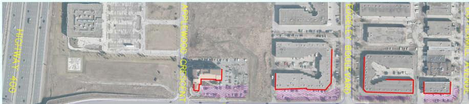
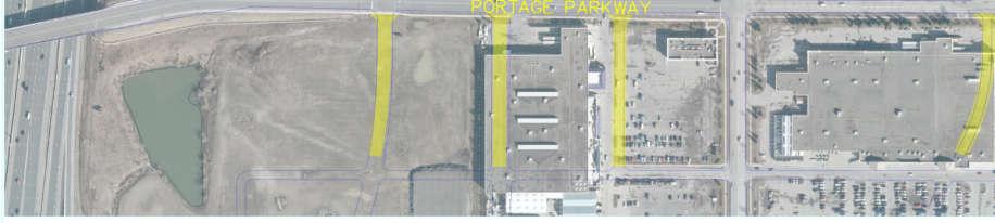
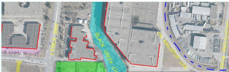
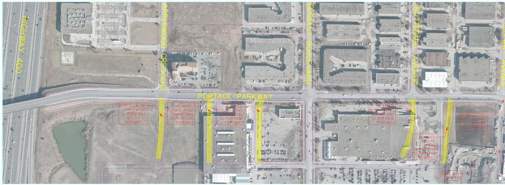
16 Existing Conditions - Portage Parkway, Applewood Crescent to Creditstone Road Study Area 4 Lane Roadway 2 Lane Roadway Land Use Employment /Industrial Vaughan Metropolitan Centre Secondary Plan Area Heritage Property Existing Sidewalk CN Rail Spur Black Creek Channel CN RAIL SPUR LINE PART A BOULEVARD LANDSCAPED WITH KENTUCKY BLUEGRASS AND NURSERY TREES BLACK CREEK FLOWS NORTH-SOUTH PART B Notes: Road Features: Posted speed limit is 50 km/h Natural Sciences: Vegetation communities include old field cultural meadow and deciduous forest Stage 1 Archaeological Assessment: Most of the study area has low to no archaeological potential; Sections found to have archaeological potential require a Stage 2 assessment PART A and PART B areas are conceptual subject to EA study 16
17 Alternative Planning Solutions in the Transportation Master Plan Problem or opportunity identified in the Transportation Master Plan Highway 7 is designated as a Rapid Transit corridor and, thus, will not be able to supply additional road capacity to the area. Alternative solution considered by the Transportation Master Plan: Need for parallel east-west collector roads extending throughout the VMC, optimizing network flexibility and providing additional east-west capacity. Impacts assessed in the Transportation Master Plan: The VMC area has long been designated for major growth and is located well beyond the Oak Ridges Moraine and the Green Belt, and will therefore not significantly impact the natural heritage network. Transportation Master Plan A New Path, City of Vaughan,
18 Alternative Planning Solutions for Portage Parkway Do Nothing Travel Demand Management Initiatives (e.g., flexible work hours, telecommuting, carpooling) Alternative Modes of Transportation (e.g., cycling and walking facilities, transit) Localized Intersection and Operational Improvements (e.g., traffic signals, turning lanes) Widening Portage Parkway from Applewood Crescent to Jane Street (e.g., 2 to 4 lanes) Extending Portage Parkway from Jane Street to Creditstone Road (e.g., new 4 lane roadway) 18
19 Summary of Alternative Planning Solutions Alternative Advantages Disadvantages Summary Do Nothing No natural environmental impacts Does not accommodate future traffic growth Does not address Does not conform to VMC Secondary Plan / Transportation Master Plan (TMP) problem and opportunity statement No improvements to traffic safety Carried forward for comparative evaluation Travel Demand Management Initiatives Alternative Modes of Transportation Indirect improvements encourage alternative transportation Long term potential for increased traffic capacity Partially conforms to VMC Secondary Plan / TMP Long term potential for reduction in vehicular emissions Direct and indirect improvements encourage alternative transportation Partial reduction of traffic volumes Partially conforms to VMC Secondary Plan / TMP / Pedestrian and Cycling Master Plan Potential for minor improvements to aesthetics and streetscape Low construction / implementation costs Does not accommodate future traffic growth No improvements to traffic safety Does not accommodate future traffic growth No impact to traffic safety Low potential for archaeological impact Carried forward as part of recommended solution Carried forward as part of recommended solution 19
20 Summary of Alternative Planning Solutions Alternative Advantages Disadvantages Summary Localized Intersection and Carried Forward Operational Improvements Widening Portage Parkway from Applewood Crescent to Jane Street Extending Portage Parkway from Jane Street to Creditstone Road Marginally improves level of service for traffic Opportunity for gateway intersections per Streetscape and Open Space Plan Opportunity to encourage alternative transportation Improves level of service for traffic Conforms to VMC Secondary Plan / TMP Opportunity to address traffic operations Opportunity to improve aesthetics and streetscape per VMC Streetscape and Open Space Plan Improves access to industry and businesses Improves emergency access Opportunity to encourage alternative transportation Conforms to VMC Secondary Plan / TMP Provides alternative route for truck traffic Improves access to industry and businesses Improves emergency route Does not accommodate future traffic growth Low construction costs Increases surface area contributing to storm-water runoff Low potential for archaeological impact Property required High construction costs Increases surface area contributing to storm-water runoff Potential traffic noise impact Potential environmental issues Low potential for archaeological impact Property required High construction costs Carried Forward Carried Forward 20
21 Recommended Solution The recommended solution for Portage Parkway is a combination of alternatives: Travel Demand Management Initiatives were identified in the Transportation Master Plan and are being implemented by the City as a separate strategy Alternative Modes of Transportation were identified in the Transportation Master Plan, including the provision for continuous sidewalk, cycling systems, connectivity to the subway extension to Highway 7, and rapid transit on Jane Street Localized Intersection and Operational Improvements (e.g., traffic signals, turning lanes) Widening Portage Parkway from Applewood Crescent to Jane Street (e.g., 2 to 4 lanes) Extending Portage Parkway from Jane Street to Creditstone Road (e.g., new 4 lane roadway) 21

22 Design - VMC Secondary Plan The VMC Plan Secondary Plan Draft Consolidation Proposed Modifications WITHOUT PREJUDICE, Urban Strategies Inc., September


23 Design Framework Typical Streetscape Elements for Mid-Block Vaughan Metropolitan Centre Streetscape and Open Space Plan, EDA Collaborative Inc., Draft January
24 Design Evaluation Criteria Criteria considered for high level assessment and comparison of alternative planning solutions: Cultural Natural Archaeology Aquatic Built Heritage and Cultural Landscapes Avian and Wildlife Economic Natural Areas Capital Costs Species at Risk Vegetation Implementation Watercourses Regulatory Framework Staging Social Municipal Servicing Coordination Air Quality Businesses Infrastructure Planning Emergency Services Alternative Transportation Land Use Streetscape Noise Level of Service Property Access Network Capacity Planning Policy (Official/Secondary Plans, Transportation Master Plans) Stormwater Management / Creek Crossing Traffic Safety 24

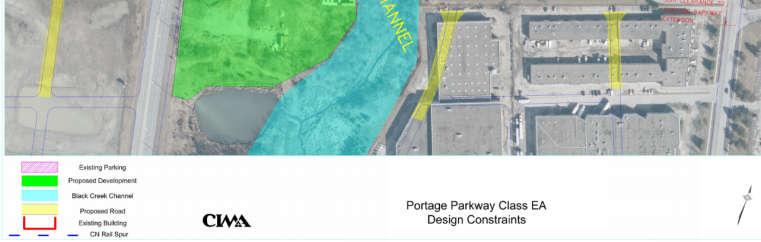

25 Design Opportunities and Constraints 25
26 Design Opportunities and Constraints 26


27 Next Steps Review your input Finalize Problem and Opportunity Statement Finalize Preferred Planning Solution Identify and Assess Alternative Design Concepts Identify preliminary preferred design concept Host meetings with Technical Agencies and Stakeholders Host Public Information Centre No. 2 in

28 What do you think? Please share your comments with either Project Manager by December 11, 2015: Marta Roias, RPP City of Vaughan Project Manager 2141 Major Mackenzie Drive Vaughan, ON L6A 1T1 T: Ext F: E: Stephen Keen, P.Eng. CIMA+ Project Manager 3027 Harvester Road, Suite 400 Burlington, ON L7N 3G7 T: Ext F: E: Thank you for attending this PIC 28
Commissioners Road West Realignment Environmental Assessment
 City of London Commissioners Road West Realignment Environmental Assessment Public Information Centre No. 1 March 30, 2017 Welcome to the Public Information Centre This first Public Information Centre
Commissioners Road West Realignment Environmental Assessment
 City of London Commissioners Road West Realignment Environmental Assessment Public Information Centre No. 2 November 29, 2017 Welcome to the Public Information Centre This 2 nd Public Information Centre
Heritage Road Improvements from Steeles Avenue to Rivermont Road
 The Corporation of the City of Brampton Heritage Road Improvements from Steeles Avenue to Rivermont Road Class Environmental Assessment Study (Schedule C) September 19, 2013 The Corporation of the City
The Corporation of the City of Vaughan
 The Corporation of the City of Vaughan Portage Parkway Class Environmental Assessment Portage Parkway Widening and Easterly Extension to West of Black Creek Environmental Study Report Part A July 2016
The Corporation of the City of Vaughan
 The Corporation of the City of Vaughan Portage Parkway Class Environmental Assessment Portage Parkway Extension from West of Black Creek to Creditstone Road Environmental Study Report Part B FINAL September
Vaughan Metropolitan Centre (VMC) Black Creek Renewal CLASS ENVIRONMENTAL ASSESSMENT
 Black Creek Renewal CLASS ENVIRONMENTAL ASSESSMENT") PUBLIC INFORMATION CENTRE Vaughan Metropolitan Centre (VMC) Black Creek Renewal Wednesday, May 10, 2017 6:00 p.m. to 8:00 p.m. Add photo Project Management, Environmental Assessment, Stormwater Management
PUBLIC INFORMATION CENTRE Vaughan Metropolitan Centre (VMC) Black Creek Renewal Wednesday, May 10, 2017 6:00 p.m. to 8:00 p.m. Add photo Project Management, Environmental Assessment, Stormwater Management
WELCOME TO OPEN HOUSE TWO November 28, 2018
 Langstaff Road Weston Road to Highway 7 Class Environmental Assessment Study WELCOME TO OPEN HOUSE TWO November 28, 2018 Please sign in and join our mailing list Study Overview York Region is conducting
City of Toronto. Emery Village Transportation Master Plan
 City of Toronto Emery Village Transportation Master Plan May 2009 Emery Village Transportation Master Plan Toronto, ON May 2009 Consulting Inc. 100 York Blvd., Suite 300 Richmond Hill, ON L4B 1J8 Tel:
Bostwick Road. Municipal Class Environmental Assessment. October 13, City of London. Bostwick Road Municipal Class Environmental Assessment
 Bostwick Road Municipal Class Environmental Assessment October 13, 2016 Welcome! Welcome to the first Public Information Centre for the Bostwick Road Municipal Class Environmental Assessment. Representatives
Bostwick Road. Municipal Class Environmental Assessment. Public Information Centre #2 June 14, City of London
 Bostwick Road Municipal Class Environmental Assessment Public Information Centre #2 June 14, 2017 Welcome! Welcome to the 2 nd Public Information Centre for the. Representatives from the and the consulting
The West Vaughan Employment Area Secondary Plan Policies
 Part 2: The West Vaughan Employment Area Secondary Plan Policies 2.1 General Policies It is the policy of Council: 2.1.1. That the West Vaughan Employment Area (the WVEA), identified on Schedule 1, will
Mavis Road Class Environmental Assessment
 Mavis Road Class Environmental Assessment Public Information Centre #2 Wednesday November 9, 2016 6:00 to 8:00 p.m. Please sign in and complete a comment sheet Review the displays on your own or join in
Public Information Centre #1
 and Highway 401 Interchange Improvements WELCOME Public Information Centre #1 Veterans Memorial Parkway Extension and Highway 401 Interchange Improvements Study May 23, 2012 4 p.m. to 7 p.m. Brief Overview
St. Clair Avenue West Area Transportation Master Plan
 1 (Between Keele Street and Old Weston Road) Public Information Centre 1 December 2, 2015 2 Welcome Welcome to the first Public Information Centre for the St. Clair Avenue West Area. The panels will present
Improvements Municipal Class Environmental Assessment. Public Information Centre #1 June 11, 2015
 Western Road & Sarnia Road/Philip Aziz Avenue Improvements Municipal Class Environmental Assessment Public Information Centre #1 June 11, 2015 1. Welcome We re hosting this Public Information Centre (PIC)
PUBLIC OPEN HOUSE HURONTARIO-MAIN CORRIDOR SECONDARY PLAN
 PUBLIC OPEN HOUSE HURONTARIO-MAIN CORRIDOR SECONDARY PLAN Tuesday, February 28, 2012 6pm 9pm 1 st Floor Atrium, City Hall 2 Wellington Street West, Brampton 1 POLICY FRAMEWORK The 2006 Provincial Growth
WELCOME and introduction
 1 WELCOME and introduction Mobility Hub Locations within Burlington STUDY OVERVIEW STUDY OBJECTIVES The City of Burlington is developing four Area Specific Plans, one for each of Burlington s Mobility
Shift Rapid Transit Public Participation Meeting May 3, 2017
 Shift Rapid Transit Public Participation Meeting May 3, 2017 Shift Rapid Transit Initiative Largest infrastructure project in the city s history. Rapid Transit initiative will transform London s public
9 CITY OF VAUGHAN OFFICIAL PLAN AMENDMENT NO BOCA EAST INVESTMENTS LIMITED
 9 CITY OF VAUGHAN OFFICIAL PLAN AMENDMENT NO. 631 - BOCA EAST INVESTMENTS LIMITED The Planning and Economic Development Committee recommends the adoption of the recommendations contained in the following
Introduction. Public Information Package. Project website. Overview. Class Environmental Assessment Process
 1 Introduction Public Information Package Baseline Road Extension between Lambs Road and Bennett Road, Bowmanville Schedule B Municipal Class Environmental Assessment November 6, 2017 Overview The purpose
Complete Neighbourhood Guidelines Review Tool
 Complete Neighbourhood Guidelines Review Tool Prepared By: City of Regina Planning Department October 2014 Page 1 of 14 Community Development Review Checklist for Secondary Plans and Concept Plans The
1.0 Purpose of a Secondary Plan for the Masonville Transit Village
 Report to Planning and Environment Committee To: Chair and Members Planning & Environment Committee From: John M. Fleming Managing Director, Planning and City Planner Subject: Masonville Transit Village
Highway 427 Industrial Secondary Plan Area 47 Schedule C Class Environmental Assessment For Arterial Roadways
 Welcome to Pubic Information Centre #1 Highway 427 Industrial Secondary Plan Area 47 Schedule C Class Environmental Assessment For Arterial Roadways Welcome to Open House # 1 Tonight, we invite you to.
Municipal Class EA Study Public Information Centre No. 1 December 13, :00 pm 7:00 pm. Please sign in so we can keep you updated on this study
 Reconstruction of Regional Road 45 (Creek Road) Between Regional Road 27 (River Road) and Regional Road 63 (Canborough Road) in the Township of Wainfleet Municipal Class EA Study Public Information Centre
12 AMENDMENT NO. 149, TOWN OF MARKHAM HIGHWAY 404 NORTH SECONDARY PLAN
 12 AMENDMENT NO. 149, TOWN OF MARKHAM HIGHWAY 404 NORTH SECONDARY PLAN The Planning and Economic Development Committee recommends the adoption of the recommendation contained in the following report August
FANSHAWE PARK ROAD/RICHMOND STREET INTERSECTION IMPROVEMENTS. PUBLIC INFORMATION CENTRE 2 June 16, 2016
 FANSHAWE PARK ROAD/RICHMOND STREET INTERSECTION IMPROVEMENTS Municipal Class Environmental Assessment PUBLIC INFORMATION CENTRE 2 June 16, 2016 ACCESSIBILITY Under the Accessibility Standards 2015 for
Edgeley Pond + Park Public Meeting
 Edgeley Pond + Park Public Meeting February 21, 2017 Purpose of the meeting This Public Meeting is an opportunity for you to review the project background, process and provide input. City of Vaughan staff
Rapid Transit Implementation Working Group September 14, 2017
 Rapid Transit Implementation Working Group September 14, 2017 BACKGROUND Council approved the Rapid Transit Master Plan and Updated Business Case on July 25, 2017. Approval of the RTMP confirmed the BRT
COUNCIL ATTACHMENT 2 HIGHWAY 7 CORRIDOR AND VAUGHAN NORTH-SOUTH LINK
 COUNCIL ATTACHMENT 2 HIGHWAY 7 CORRIDOR AND VAUGHAN NORTH-SOUTH LINK Welcome! The purpose today is to: Present the Study Background; Describe Alignment Alternatives Analyzed; Present the Evaluation of
11.12 Vaughan Metropolitan Centre Secondary Plan
 City of Vaughan Official Plan Volume 2 2017 Office Consolidation As Partially Approved by the Ontario Municipal Board 11.12 Vaughan Metropolitan Centre Secondary Plan PARTIALLY APPROVED BY THE ONTARIO
CITY OF VAUGHAN EXTRACT FROM COUNCIL MEETING MINUTES OF JUNE 7, 2016
 Item 5, Report No. 26, of the Committee of the Whole (Working Session), which was adopted without amendment by the Council of the City of Vaughan on June 7, 2016. 5 MUNICIPAL CLASS ENVIRONMENTAL ASSESSMENT
Second Line West Pedestrian/Cyclist Crossing of Highway 401 Class EA. Second Line West Pedestrian/Cyclist Crossing of Highway 401 Class EA
 1 1 Purpose of Public Information Centre #2 To provide interested and/or potentially affected stakeholders with an opportunity to participate in the planning and decision-making process for this Municipal
Western Road/Wharncliffe Road North Widening from Platts Lane to Oxford Street. Municipal Class Environmental Assessment Public Information Centre #1
 Western Road/Wharncliffe Road North Widening from Platts Lane to Oxford Street Municipal Class Environmental Assessment Public Information Centre #1 June 11, 2014 Welcome Welcome to the first Public Information
Public Meeting #3 May 9, 2009 MVVA Team
 Public Meeting #3 May 9, 2009 MVVA Team Welcome to the third Public Meeting for the Lower Don Lands Municipal Class Environmental Assessment (EA) Infrastructure Master Plan and Keating Channel Precinct
Purpose of Open House #3
 Public Meeting #3 May 9, 2009 MVVA Team Purpose of Open House #3 The main purpose of this Open House is to present and seek input on the: Evaluation of transportation and infrastructure design alternatives
WELCOME TO OPEN HOUSE # 3
 Bayview Avenue Class Environmental Assessment Study Steeles Avenue to Elgin Mills Road WELCOME TO OPEN HOUSE # 3 Please sign in and join our mailing list Why Are We Here Tonight? Study Process and Purpose
1.0 INTRODUCTION AND BACKGROUND
 1.0 INTRODUCTION AND BACKGROUND 1.1 INTRODUCTION / BACKGROUND The Regional Municipality of York (hereafter referred to as York Region ) has completed a Municipal Class Environmental Assessment (Class EA)
Integration of Trees into Roads Policy - the road to success -
 Integration of Trees into Roads Policy - the road to success - Trees, People and the Built Environment 3 City of Birmingham, UK April 5 th, 2017 Ian Buchanan Natural Heritage and Forestry Regional Municipality
London s Bus Rapid Transit System
 London s Bus Rapid Transit System HERITAGE WORKSHOP November 7, 2017 1 Agenda 1. Introductions 2. Overview of Transit Project Assessment Process 3. Archaeology and Heritage Approval Process 4. Role of
Mehemed Delibasic, P.Eng Project Manager Transportation Planning and Traffic Engineering AECOM CANADA Ltd.
 Mehemed Delibasic, P.Eng Project Manager Transportation Planning and Traffic Engineering AECOM CANADA Ltd. Currently, Mehemed is employed with AECOM Canada Ltd as a Project Manager (Transportation Planning
SCARBOROUGH SUBWAY EXTENSION. Scarborough Subway Extension. Final Terms of Reference
 Scarborough Subway Extension Final Terms of Reference 1 1.0 Introduction and Background 1.1 Introduction Toronto City Council recently confirmed support for an extension of the Bloor-Danforth Subway from
Vaughan Metropolitan Centre UTILITY MASTER PLAN
 Vaughan Metropolitan Centre UTILITY MASTER PLAN May 24, 2017 Executive Summary The Vaughan Metropolitan Centre (VMC) is under construction. The fast paced development activity in the VMC currently underway
City of Cornwall Municipal Class Environmental Assessment. Proposed Improvement and Extension of Lemay Street
 Welcome City of Cornwall Municipal Class Environmental Assessment Proposed Improvement and Extension of Lemay Street Redevelopment and Design of the Municipal Works Yard Public Information Centre #1 Thursday,
Report to: Development Services Committee Report Date: April 24, 2017
 SUBJECT: Cornell Rouge National Urban Park Gateway - Report on Design Charrette and Next Steps PREPARED BY: Lilli Duoba, MES, MCIP, RPP, Manager, Natural Heritage (ext. 7925) REVIEWED BY: Marg Wouters,
Emery Village Road 2A Municipal Class Environmental Assessment Study
 PW12.11 STAFF REPORT ACTION REQUIRED Emery Village Road 2A Municipal Class Environmental Assessment Study Date: March 30, 2016 To: From: Wards: Reference Number: Public Works and Infrastructure Committee
Rapid Transit Implementation Working Group
 Rapid Transit Implementation Working Group October 12, 2017 1 Agenda 1. Consultation Update 2. Technical Work Update 3. LTC Rapid Transit Integration 4. Next Steps 2 Consultation Update 3 Consultation
38 Queen s University Campus Master Plan Part 1
 38 Queen s University Campus Master Plan Part 1 46 The Campus at the City Scale Chapter 4 The Campus at the City Scale 39 Queen s is an urban University centrally located in Kingston. Decisions made by
Environmental Study Report
 Square One Drive Extension Municipal Class Environmental Assessment and Preliminary Design Prepared for: City of Mississauga Prepared by: Stantec Consulting Ltd. 300W-675 Cochrane Drive Markham, ON L3R
Master Environmental Servicing Plan & Secondary Plan
 East Side Lands Stage 2 1 Master Environmental Servicing Plan & Secondary Plan Public Information Centre #1 June 16, 2016 Welcome! Today s Agenda Please sign in at the front desk. 5:30 pm 6:30 pm: Open
AMENDMENT NO. 30 TO THE OFFICIAL PLAN OF THE TOWN OF MILTON
 AMENDMENT NO. 30 TO THE OFFICIAL PLAN OF THE TOWN OF MILTON Subject: Boyne Survey Secondary Plan and Related Official Plan Amendments The following text and schedules constitute Amendment No. 30 to the
Master Plan Class Environmental Assessment for Downtown Mississauga Road Improvements
 Master Plan Class Environmental Assessment for Downtown Mississauga Road Improvements Public Information Centre # 1 Wednesday June 25, 2014 5:30 p.m. to 8:00 p.m. Mississauga Civic Centre Great Hall Welcome
SUBJECT: Proposed Downtown Mobility Hub Precinct Plan and Proposed Official Plan Policies
 Page 1 of Report PB-81-17 SUBJECT: Proposed Downtown Mobility Hub Precinct Plan and Proposed Official Plan Policies TO: FROM: Committee of the Whole Planning and Building Department Report Number: PB-81-17
Adelaide Street / Canadian Pacific Railway (CPR) Grade Separation. Public Information Centre #1
 Grade Separation. Public Information Centre #1") 1 Adelaide Street / Canadian Pacific Railway (CPR) Why Are We Here? 2 The purpose of Public Information Centre (PIC) #1 is to: Introduce the study Provide the study background and context Identify the
1 Adelaide Street / Canadian Pacific Railway (CPR) Why Are We Here? 2 The purpose of Public Information Centre (PIC) #1 is to: Introduce the study Provide the study background and context Identify the
AGINCOURT SECONDARY PLAN
 1 AGINCOURT SECONDARY PLAN 1. AGINCOURT SECONDARY PLAN The following policies and principles apply to the area herein referred to as Agincourt, as outlined on Map 1-1. 1. GENERAL POLICIES 1.1 This Secondary
CITY OF VAUGHAN KIRBY GO TRANSIT HUB SUB-STUDY
 WELCOME! Thank you for attending, and welcome to the first of three Public Meetings for the Kirby GO Transit Hub Study. Your feedback is important to us, and will help inform the development of the draft
ELMVALE ACRES SHOPPING CENTRE MASTER PLAN
 ELMVALE ACRES SHOPPING CENTRE MASTER PLAN Contents 1.0 INTRODUCTION... 2 2.0 LOCATION... 2 3.0 EXISTING CONTEXT... 2 4.0 VISION & GUIDING PRINCIPLES... 2 5.0 LAND USE AND BUILT FORM... 4 5.1 St. Laurent
Summary of Changes for the Comprehensive Draft Proposed Official Plan Amendment
 Summary of Changes for the Comprehensive Draft Proposed Official Plan Amendment Note: Due to the broad scope of the Official Plan Review, this list is not exhaustive of the extent of changes in the comprehensive
South Yonge Street Corridor
 South Yonge Street Corridor Streetscape Master Plan Study Draft Final Executive Summary Prepared by: January 2012 In Partnership with: Introduction The Future... Yonge Street is at the forefront of York
2 STATUTORY PUBLIC MEETING AND INFORMATION REPORT FOR PUBLIC MEETING ON AMENDMENT NO. 62 TO THE YORK REGION OFFICIAL PLAN
 2 STATUTORY PUBLIC MEETING AND INFORMATION REPORT FOR PUBLIC MEETING ON AMENDMENT NO. 62 TO THE YORK REGION OFFICIAL PLAN Pursuant to Section 17(15) of the Planning Act, as amended, the Regional Planning
John M. Fleming Managing Director, Planning and City Planner. Old East Village Dundas Street Corridor Secondary Plan Draft Terms of Reference
 Report to Planning and Environment Committee To: From: Subject: Chair and Members Planning & Environment Committee John M. Fleming Managing Director, Planning and City Planner Old East Village Dundas Street
Update. What is the Osborne Bridge Rehabilitation project all about and how is it being planned? Neighbourhood Advisory Committee (NAC)
") Update JANUARY 2010 Neighbourhood Advisory Committee (NAC) ARTS AND CULTURE Gas Station Theatre BUSINESS Osborne Village BIZ Downtown BIZ COMMERCIAL PROPERTY OWNER Great-West Life COMMUNITY ORGANIZATIONS
Update JANUARY 2010 Neighbourhood Advisory Committee (NAC) ARTS AND CULTURE Gas Station Theatre BUSINESS Osborne Village BIZ Downtown BIZ COMMERCIAL PROPERTY OWNER Great-West Life COMMUNITY ORGANIZATIONS
SPECIAL COMMITTEE OF THE WHOLE DECEMBER 9, 2002 BLOCK 57/58 WEST BLOCK PLAN BLOCK PLAN FILE BL.57/58W.99 HUNTINGTON BUSINESS PARK LAND OWNERS
 SPECIAL COMMITTEE OF THE WHOLE DECEMBER 9, 2002 BLOCK 57/58 WEST BLOCK PLAN BLOCK PLAN FILE BL.57/58W.99 HUNTINGTON BUSINESS PARK LAND OWNERS Recommendation The Commissioner of Planning recommends: THAT
3 Development Process 3.1 Stage One page Stage Two page Stage Three page CENTRAL PICKERING DEVELOPMENT PLAN
 3 Development Process 3.1 Stage One page 24 3.2 Stage Two page 25 3.3 Stage Three page 28 22 CENTRAL PICKERING DEVELOPMENT PLAN The Central Pickering Development Plan establishes the key elements of new
Inform you of the purpose and scope of the study for PTH 100 and a proposed future St. Norbert Bypass;
 WELCOME The intent of today s Open House is to: Inform you of the purpose and scope of the study for PTH 100 and a proposed future St. Norbert Bypass; Review highway crossing locations, future access closures
Committee of the Whole (Public Hearing) Report
 Report") Item:1 Committee of the Whole (Public Hearing) Report DATE: Tuesday, June 05, 2018 WARD: 2 TITLE: OFFICIAL PLAN AMENDMENT FILE OP.17.016 ZONING BY-LAW AMENDMENT FILE Z.17.046 IMPORTANNE MARKETING INC.
Item:1 Committee of the Whole (Public Hearing) Report DATE: Tuesday, June 05, 2018 WARD: 2 TITLE: OFFICIAL PLAN AMENDMENT FILE OP.17.016 ZONING BY-LAW AMENDMENT FILE Z.17.046 IMPORTANNE MARKETING INC.
Director, Community Planning, Toronto and East York District
 Lower Yonge Precinct Plan Update STAFF REPORT ACTION REQUIRED Date: October 16, 2012 To: From: Wards: Reference Number: Toronto and East York Community Council Director, Community Planning, Toronto and
SUBJECT: GO Station Mobility Hubs Preferred Concepts: Aldershot GO, Burlington GO and Appleby GO. Planning and Development Committee - Public Meeting
 Page 1 of Report PB-76-17 SUBJECT: GO Station Mobility Hubs Preferred Concepts: Aldershot GO, Burlington GO and Appleby GO TO: FROM: Planning and Development Committee - Public Meeting Planning and Building
13 THORNHILL YONGE STREET STUDY IMPLEMENTATION CITY OF VAUGHAN OPA 669 AND TOWN OF MARKHAM OPA 154
 13 THORNHILL YONGE STREET STUDY IMPLEMENTATION CITY OF VAUGHAN OPA 669 AND TOWN OF MARKHAM OPA 154 The Planning and Economic Development Committee recommends the adoption of the recommendations contained
Master Environmental Servicing Plan & Secondary Plan
 1 East Side Lands Stage 2 Master Environmental Servicing Plan & Secondary Plan Public Consultation Centre #4 March 20, 2018 Welcome! Today s Agenda Please sign in at the registration table. 6:00 pm 6:30
1.0 Introduction. Purpose and Basis for Updating the TMP. Introduction 1
 1.0 Introduction The Town of Castle Rock is situated between the metropolitan areas of Denver and Colorado Springs, amidst a unique terrain of rolling hills, mesas, ravines, and waterways. Like many Front
Clair-Maltby Community visioning
 Clair-Maltby Community visioning workshop #1 Summary April 27th, 2017 Table of Contents INTRODUCTIon 1 PURPOSE 1 CONSULTATION STRUCTURE 2 PARTICIPANT FEEDBACK 3 VISIONING EXERCISE 8 ONLINE SURVEY RESULTS
THAT the attached Terms of Reference for the Thornhill Centre Street Study be approved.
 COMMITTEE OF THE WHOLE AUGUST 18, 2003 THORNHILL CENTRE STREET STUDY PLANNING FILE: 15.92 Recommendation The Commissioner of Planning recommends: THAT the attached Terms of Reference for the Thornhill
Welcome to the LYNX Blue Line Extension Transit Station Area Plans Public Workshop No. 3. Presentation will begin at 6:00 P.M.
 Welcome to the LYNX Blue Line Extension Transit Station Area Plans Public Workshop No. 3 Presentation will begin at 6:00 P.M. Meeting Agenda Blue Line Extension (BLE) Project Update LYNX Blue Line Extension
CONSULTING SERVICES FOR THE WHITEBELT VISIONING EXERCISE ADDENDUM TO THE GTA WEST LAND USE STUDY WORK PROGRAM
 CONSULTING SERVICES FOR THE WHITEBELT VISIONING EXERCISE ADDENDUM TO THE GTA WEST LAND USE STUDY 1. Introduction WORK PROGRAM The Town of Caledon is a large, local municipality located in the Greater Toronto
Further input invited as Colchester Growth Strategy nears final phase
 IUE 3 / NOVEMBER 2015 Further input invited as Colchester Growth trategy nears final phase trathcona County is seeking public feedback as it enters the final phase of work on a Growth Management trategy
SOUTHWEST TRANSITWAY (STAGE 2) PUBLIC OPEN HOUSE
 PUBLIC OPEN HOUSE") WELCOME! SOUTHWEST TRANSITWAY (STAGE 2) PUBLIC OPEN HOUSE Monday, November 18, 2013 3:30 to 5:30PM and 7:00 to 9:00PM Tuesday, November 19, 2013 3:30 to 5:30PM and 7:00 to 9:00PM Welcome to the Southwest
WELCOME! SOUTHWEST TRANSITWAY (STAGE 2) PUBLIC OPEN HOUSE Monday, November 18, 2013 3:30 to 5:30PM and 7:00 to 9:00PM Tuesday, November 19, 2013 3:30 to 5:30PM and 7:00 to 9:00PM Welcome to the Southwest
Public input has been an important part of the plan development process.
 Lakewood s Comprehensive Plan recognizes that transportation helps shape the community, and that the way the community provides for the safe and efficient movement of people affects the character of the
Macintosh HD:CURRENT WORK-(JRW):4026 Northumberland Trent River Crossings:4026_Mem- Pannu_Report(jm)Oct2510.docx
:4026 Northumberland Trent River Crossings:4026_Mem- Pannu_Report(jm)Oct2510.docx") MEMORANDUM To: Mobushar Pannu, County of Northumberland From: Nick McDonald Date: October 27, 2010 Re: First Draft of Report (Trent River Crossing) Our File No: 4026 Attached to this memorandum is a first
MEMORANDUM To: Mobushar Pannu, County of Northumberland From: Nick McDonald Date: October 27, 2010 Re: First Draft of Report (Trent River Crossing) Our File No: 4026 Attached to this memorandum is a first
Gold Line Bus Rapid Transit Transit Oriented Development (BRTOD) Helmo Station Area Plan
 Helmo Station Area Plan") Appendix F Gold Line Bus Rapid Transit Transit Oriented Development (BRTOD) Helmo Station Area Plan Introduction and Purpose of the Plan The Gold Line Bus Rapid Transit facility is an eleven-mile dedicated
Appendix F Gold Line Bus Rapid Transit Transit Oriented Development (BRTOD) Helmo Station Area Plan Introduction and Purpose of the Plan The Gold Line Bus Rapid Transit facility is an eleven-mile dedicated
Report to: Development Services Committee Report Date: September 11, 2017
 ~RKHAM Report to: Development Services Committee Report Date: September 11, 2017 SUBJECT: PREPARED BY: Conceptual Master Plan for the Future Urban Area - Community Structure Plan and Key Policy Direction
Street Flooding Mitigation Plan KYOVA Interstate Planning Commission. Presented to AMPO National Conference October 18, 2017
 Street Flooding Mitigation Plan KYOVA Interstate Planning Commission Presented to AMPO National Conference October 18, 2017 Saleem Salameh, Ph.D., P.E., M.ASCE Chet Parsons, AICP CTP Agenda: Background
DUFFERIN CENTRE STUDY REPORT March 7, 2017 DRAFT. with Poulos & Chung Limited
 DUFFERIN CENTRE STUDY REPORT March 7, 2017 DRAFT with Poulos & Chung Limited DUFFERIN CENTRE STUDY REPORT March 7, 2017 with Poulos & Chung Limited \\ toc CONTENTS intro Introduction 1 1 2 3 Background
Better Cycling. The City will update the cycling master plan (London ON Bikes) based on the approved BRT network.
 based on the approved BRT network.") Better Cycling Dedicated bike facilities will be constructed along BRT corridors where space is available. Nearby bike routes will also be upgraded to ensure a complete network is available for cyclists.
Better Cycling Dedicated bike facilities will be constructed along BRT corridors where space is available. Nearby bike routes will also be upgraded to ensure a complete network is available for cyclists.
Growth Area Reviews Preliminary Directions for Midtown Oakville, the Uptown Core and Palermo Village
 Growth Area Reviews Preliminary Directions for Midtown Oakville, the Uptown Core and Palermo Village Livable Oakville Council Subcommittee January 15, 2018 1 Introduction Why a study? January 2014 Signaled
Public Information Centre. Welcome
 Transportation Improvements from the Beaver Creek Bridge to the Entrance of Santa s Village District of Muskoka Municipal Class Environmental Assessment Welcome Please sign in Take a comment sheet Staff
Clairtrell Area Context Plan
 Clairtrell Area Context Plan March 2005 Urban Development Services City Planning Contents 1. Introduction... 4 2. Development Structure... 6 2.1 Streets... 7 2.1.1 Sheppard Avenue and Bayview Avenue...
CITY COUNCIL AGENDA REPORT
 CITY COUNCIL AGENDA REPORT Subject: COUNCIL MOTION LRT ALIGNMENT REMOVAL FROM THE TRANSPORTATION MASTER PLAN On February 10, 2016 Councillor Hughes provided notice in accordance with Section 23 of Procedure
Transportation. Strategies for Action
 Transportation A major priority for the Overlake Neighborhood is to develop a multimodal transportation system. To achieve this system, a balance has to be found among travel, circulation and access needs;
Appendix B-13: Community Stakeholders Group Meeting Materials and Minutes
 Appendix B-13: Community Stakeholders Group Meeting Materials and Minutes PREPARED BY IBI Group and WSP London s Rapid Transit Initiative Community Stakeholder Group Meeting Summary Report for October
Potential Green Infrastructure Strategies May 6, 2015 Workshop
 Potential Green Infrastructure Strategies May 6, 2015 Workshop Background The City of Cortland is developing the Tioughnioga Urban Headwaters Green Infrastructure Action Plan with funding from the National
URBAN DESIGN BRIEF. Terms of Reference. Purpose. When is an Urban Design Brief Required
 Purpose An Urban Design Brief (UDB) is intended to describe and illustrate proposed designs for new development projects and demonstrate how the City s Urban Design Guidelines and other City policies have
Welcome. Community Consultation Meeting November 28, Review and discuss the Bathurst Quay Neighbourhood Plan Framework
 Welcome Community Consultation Meeting November 28, 2016 Why Are We Here Today? Review and discuss the Bathurst Quay Neighbourhood Plan Framework Review and discuss an Action Plan for Implementation Next
Services Department F May 28, 2007
 Report To: Development Services Committee Item: Date of Report: From: DS-07-144 May 23, 2007 Commissioner, Development File: Date of Meeting: Services Department F-7000-0013 May 28, 2007 Subject: Gibb
Elfrida Growth Area Study
 Elfrida Growth Area Study Public Information Centre #2 December 6, 2017 6:00-8:30 pm PLANNING & ECONOMIC DEVELOPMENT DEPARTMENT Purpose of the Study The Elfrida Area has been identified as the preferred
PD&E STUDY SR 9/I-95 FROM SOUTH OF SR 870/COMMERCIAL BOULEVARD TO NORTH OF CYPRESS CREEK ROAD FM # ETDM 14222
 PD&E STUDY SR 870/COMMERCIAL BOULEVARD TO NORTH OF CYPRESS CREEK ROAD FM # 435808-1-22-02 ETDM 14222 WELCOME TO THE KICK-OFF MEETING May 24, 2016 1 1 2 3 4 5 6 PLANNING PROJECT DEVELOPMENT AND ENVIRONMENT
The Gore Road Queen Street East to Castlemore Road
 Municipal Class Environmental Assessment The Gore Road Queen Street East to Castlemore Road Public Open House # 1 Date: Thursday May 29, 2014 Time: 5:30pm to 8:30pm Location: Gore Meadows Community Centre
Case Study Presentation of the Downtown Brampton Flood Protection Class EA
 Case Study Presentation of the Downtown Brampton Flood Protection Class EA Presented by: Kenneth M. Dion, Project Director Port Lands Integration, Waterfront Toronto (formerly Senior Manager, TRCA) At:
McCowan Precinct Plan Study Background & Deliverables
 1 DRAFT & WITHOUT PREJUDICE McCowan Precinct Plan Study Background & Deliverables In September, 2011, City Planning (Scarborough District) began a study of an area within the Scarborough Centre, identified
The Corporation of the TOWN OF MILTON
 Report to: From: Chair & Members of the Administration & Planning Standing Committee W.F. Mann, Director of Planning and Development Date: April 16, 2012 PD 022-12 (Z19/11) Subject: Technical Report Proposed
The transportation system in a community is an
 7 TRANSPORTATION The transportation system in a community is an important factor contributing to the quality of life of the residents. Without a sound transportation system to bring both goods and patrons