6 ENVIRONMENTAL IMPACT ASSESSMENT METHODOLOGY
|
|
|
- Godfrey Barton
- 5 years ago
- Views:
Transcription
1 Section 6 6 ENVIRONMENTAL IMPACT ASSESSMENT METHODOLOGY An EIS sets out the findings of an EIA which is undertaken by the competent authority to assess the potential effects of certain development projects on the environment. The primary objective of an EIA is to ensure that projects which are likely to have significant effects on the environment are assessed and impacts avoided, where possible. This assessment process aims to achieve the most sustainable and environmentally friendly integration of a development with the local environment. Firstly, the planning context, the background to the project including the need for the development, the alternatives assessed and the existing and proposed development is described. This sets the reader in context as to the practical and dynamic process undertaken, in order to arrive at the layout and design of the proposed development that will cause least impact on the environment. Subsequent chapters deal with specific environmental topics for example, human beings, air, water, noise, etc. These appraisals may involve specialist studies and evaluations. The methodology applied during these specific environmental appraisals is a systematic analysis of the proposed development in relation to the existing environment. The broad methodology framework for these assessments is outlined below and is designed to be clear and concise and allow the reader to logically follow the appraisals process through each environmental topic. In some instances, more specific topic related methodologies are outlined in the relevant chapters of the EIS. The broad methodology framework used in all chapters includes: Introduction Methodology Existing Environment Summary of Key Possible Impacts Mitigation Measures Predicted Impacts after Mitigation Monitoring Conclusion and Summary References The advantage of using this framework is that it is easy to investigate each environmental topic and it facilitates easy cross-reference to specialist studies undertaken as part of the appraisals. The following sections outline the methodology used during this assessment process. The methodology has been undertaken in accordance with best practice EIS guidelines: Guidelines on the Information to be contained in Environmental Impact Statements, (EPA, 2002) Advice notes on Current Practice (in the preparation of Environmental Impact Statements) (EPA, 2003) 6.1 Environmental Appraisal Methodology Introduction This section generally introduces the environmental topic to be assessed and the areas to be examined with the appraisal Methodology Specific topic related methodologies are outlined in this section. This will include the methodology used in describing the existing environment and undertaking the impact assessment. Q:/2010/LE10/727/01/Rpt002-0.doc Page 64 of 294
2 Section 6 It is important that the methodology is documented so that the reader understands how the assessment was undertaken. This can also be used as a reference if future studies are required Existing Environment An accurate description of the existing environment is necessary to predict the likely significant impacts of a new development. Existing baseline environmental monitoring data can also be used as a valuable reference for the assessment of actual impacts from a development once it is in operation. To describe the existing environment, desktop reviews of existing data sources were undertaken for each specialist area. This literature review relied on published reference reports and datasets to ensure the objectivity of the assessment. Desktop studies are also supplemented by specialised field walkovers or studies in order to confirm the accuracy of the desktop study or to gather more baseline environmental information for incorporation into the EIS. The existing environment was evaluated to highlight the character of the existing environment that is distinctive and what the significance of this is. The significance of a specific environment can be derived from legislation, national policies, local plans and policies, guidelines or professional judgements. The sensitivity of the environment was also described Summary of Key Possible Impacts In this section individual specialists predict how the receiving environment will interact with the proposed development. The full extent of the proposed development s effects and emissions before the proposed mitigation measures are introduced is outlined here. Impacts from both the construction and operation phases of the proposed development are outlined. Interactions and cumulative impacts with other environmental topics are also included in this assessment. The evaluation of the significance of the impact is also undertaken. Where possible, pre-existing standardised criteria for the significance of impacts will be used. Such criteria can include Irish legislation, international standards, EPA guidelines or good practice guidelines. Where appropriate criteria do not exist the assessment methodology section states the criteria used to evaluate the significance Mitigation Measures If significant impacts are anticipated mitigation measures are devised to minimise impacts on the environment. Mitigation measures by avoidance, by reduction and by remedy can be outlined Predicted Impacts after Mitigation This identifies the likely impact that will occur after the proposed mitigation measures have been put in place. These impacts are described in detail and assessment of their significance undertaken Monitoring This section outlines specific monitoring programmes for the individual environmental topic to be undertaken to ensure the effectiveness of mitigation measures put forward in the EIS. Monitoring results can be compared with baseline monitoring undertaken as part of the EIS or with other regulatory standards, planning conditions, Industrial Emission, IPC or waste licence conditions, etc Conclusion and Summary An overall summary of the assessment undertaken, specific impacts predicted, mitigation measures outlined and final residual impacts is provided in this section. Q:/2010/LE10/727/01/Rpt002-0.doc Page 65 of 294
3 Section EIS Conclusion: Development and its Impacts in Context This section provides a summary of the key impacts and mitigation measures associated with the proposed development. It also discusses cumulative impacts and interactions and inter-relationships between environmental topics. This section provides an overall conclusion to the EIS. Q:/2010/LE10/727/01/Rpt002-0.doc Page 66 of 294
4 7 HUMAN ENVIRONMENT LAND USE 7.1 Introduction This section examines the potential impacts of the proposed pipeline project on land use. It covers the existing nature of the environment within the proposed planning corridor, and predicts the impacts that may be expected and the measures proposed to mitigate these effects. Consideration is given to both the construction and operational phases of the development. 7.2 Study Area The assessment area has been defined with reference to the potential for impact from the proposed scheme which is typically limited to the boundary of the pipeline planning corridor and the availability of relevant information. In terms of land use it was considered that a 500 m offset from the centerline of the proposed pipeline planning corridor would encompass all land uses directly impacted by the proposed scheme. Therefore, land use zoning and existing land uses within the 500 m offset were considered in this section. 7.3 Methodology In order to assess the existing local human environment, a desk-top study was undertaken. The areas studied included land use, education and amenity. The main land uses in the area which could be potentially impacted by the proposed project were described from Google Earth/OSI Orthophotography and this data was verified by subsequent walkovers and drive-by surveys. Heritage, culture, leisure and recreational facilities along the route were identified. A walkover of the route was subsequently conducted to confirm information. The following literature and data sources were reviewed as part of this assessment: The Dublin City Development Plan Fingal County Council Development Plan Ordnance Survey Mapping Sheet No. 50 Google Earth/OSI Orthophotography Existing Environment Human Environment - Land Use The main land use through which the route passes is roadway. The DCC and FCC Development plans outline existing and proposed land use zoning objectives within the planning corridor. These zoning objectives provide land use classification within the development plan areas. While there are a number of land use classifications within the development plans, some of these classifications are not relevant to the proposed aviation pipeline. With reference to the Dublin City and Fingal County Development Plans the following classifications are used to describe the zoning land uses surrounding the proposed pipeline route corridor. Q:/2010/LE10/727/01/Rpt002-0.doc Page 67 of 294
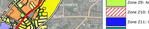
5 Table 7.1: Zoning Land Uses Within 500m of the Pipeline Corridor ZONE Zone Z1 - Sustainable Residential Neighbourhoods Zone Z2 - Residential Neighbourhoods /Conservation Areas) Plan No. of times Zoning occurs within 500 m of Pipeline Corridor Dublin City Development Plan Dublin City Development Plan Zone Z3 - Neighbourhood Centres Dublin City Development Plan Zone Z4 - District Centres Dublin City Development Plan Zone Z6 - Employment/Enterprise Zone Dublin City Development Plan Zone Z7 - Employment (Industry) Dublin City Development Plan Zone Z9 - Amenity and Open Space and Green networks Zone Z10 - Inner Suburban (Sustainable Mixed-Use) Dublin City Development Plan Dublin City Development Plan Zone Z14 - Strategic Development and Regeneration Areas Dublin City Development Plan Zone Z15 - Community and Institutional Resource Lands (Educational, Recreational, Dublin City Development Plan Community, Green Infrastructure, and Health) DA - Dublin Airport Fingal Development Plan Open Space Fingal Development Plan HT - High Technology Office, Research & development, high Fingal Development Plan technology GB -Greenbelt Recreation & community Fingal Development Plan RA - Residential Area Fingal Development Plan The distribution of these land use zonings is shown on Figure 7.1. Q:/2010/LE10/727/01/Rpt002-0.doc Page 68 of 294


6 7.1
7 A description of the dominant land uses along the proposed pipeline route corridor is provided hereunder. Table 7.2: Land Use Zoning & Classification Dublin Port and Tolka Quay Road The Dublin Port Oil Terminal and Tolka Quay Road are located in the Docklands area of the city which is under the remit of the Dublin Port Company. This area is surrounded by Dublin Harbour. Land use Employment (industrial) areas, SEVESO II establishments Description East Wall Road and Environs This area is designated as industrial land use with industrial facilities such as coal yards, oil installations, freight yards, car parks and oil and chemical storage tanks, some designated as SEVESO II sites, etc. The pipeline will commence from an AGI to locate at an existing fuel storage facility within the port. AMEC Environment & Infrastructure UK Limited prepared a Safety and Environmental Impact Evaluation Report (Appendix 2.1 of Volume 3 of the EIS) in which they identified five lower tier Seveso sites along with seven upper tier sites. While the pipeline does not cross over or through any of these sites, it does pass near to one and follows the outer wall of one of the lower tier site on Tolka Quay Road for approximately 300 m. Other land uses identified for this area are the pedestrian and cycle walkways including the Integrated S2S/Docklands cycle network which commences within the Port and passes along East Wall Road and onto Alfie Byrne Road. East Wall Road is in the Docklands area of the City and runs in an east-west direction from Tolka Quay Road to North Strand Road. (Note the proposed pipeline route does not impact on North Strand Road). Land use Residential amenity, residential amenity (conservation areas), strategic development & regeneration areas Waterway protection areas Employment/ enterprise areas. Description Significant areas to the south of East Wall Road have been designated for rejuvenation, for example, a factory area and the Docklands Innovation Park. An educational facility within this area includes Saint Joseph s National School. In addition there is a hotel, church, two medical centres, a community centre, fire station and post office. The remaining area to the south of East Wall Road is residential with terraced houses along the roadway. There are a number of residential conservation areas also designated within the region. The East Wall Road has also been identified as a priority cycle route. To the north of the East Wall Road, is the Portside Business Centre, a designated enterprise and employment centre as well as the Tolka River amenity. Alfie Byrne Road, the John McCormack Bridge Clontarf Road, Howth Road and Copeland Avenue There are a number of parks in the vicinity of the pipeline route corridor as it runs along Alfie Byrne Road. These include Fairview Park, which is located within the townland of Fairview just north of the Tolka River and west of the Tolka River Estuary/Dublin Harbour. The River Tolka is an important local fishery. The river is mostly a put and take fishery and is stocked by the Tolka Trout Angler s Club and the IFI The Alfie Byrne Open Area is also adjacent to this section of the pipeline route corridor. Q:/2010/LE10/727/01/Rpt002-0.doc Page 70 of 294
8 The route then travels a short distance (approx 650m) along the Clontarf Road before turning north-east at the John McCormack Bridge where it will cross under the Tolka River onto the Howth Road (over the port tunnel) for a distance of approximately 600 m. It then travels north-west along Copeland Avenue to join the Malahide Road. Land use Recreational amenity and amenity, open space and green networks Residential amenity, residential amenity (conservation areas) Neighbourhood centre/mixed service facilities, community/institutional areas. Description Fairview Park and Alfie Byrne Open Space are large green areas that are popular recreational areas for local workers, residents as well as visitors. There are a number of paths through the parks for recreational enjoyment as well as an access path across the River Tolka onto the East Wall Road (Fairview Park). Other facilities in these green areas include a playground, basketball ground, football pitches, etc. The DART and northern railway line passes between Fairview Park and the Alfie Byrne Open Space with the Clontarf train station on the Alfie Byrne Road. In the vicinity of this route there is a primary school, dance school, Garda station, nursing home, refugee centre, medical centres as well as a number of commercial activities including a service station and car showroom at John McCormack Bridge. Howth Road and Copeland Avenue are primarily residential areas. Malahide Road (R109) From Griffith Avenue Junction to Coolock Village Centre Malahide Road runs in a north-south direction north of Fairview Park and west from Clontarf. The proposed pipeline route corridor runs along this road from the Griffith Avenue junction, through Donnycarney and Artane to Coolock Village Centre. Land use Residential, amenity, residential amenity (conservation areas), Amenity/open space/green network areas, Employment/ enterprise zones, Neighbourhood / mixed service facilities, community/institutional areas. Description The dominant land use in this area is residential with both detached and semidetached dwellings. Some of these residential areas are designated residential conservation areas for example in Marino Cresent or along Carleton Road. Neighbourhood facilities and mixed services include veterinary clinics, local shops, bars and restaurants. In the Artane area there is an increase in industrial land use, primarily at the Fairdale Industrial Estate. There are a number of areas designated as mixed facility areas such as Artane Castle Shopping Centre and Cromcastle Court. There are several churches (5), schools (11), medical centres (2) and a community centre within a 500m buffer of the proposed pipeline route corridor in this area. There are a number of open spaces and recreational areas in close proximity to the route including an open space at the Howth Road/Clontarf Road junction, a GAA pitch within the Marino Casino Architectural Conservation Area (ACA), Clontarf Golf Course, Mayfield Park, St David s Park and Rockfield Park near the Killester Avenue junction, and Middle Park, Mask Park and McAuley Park in Artane. As well as the Marino Casino ACA, there is a protected structure at Griffith Avenue junction and near St. David s Woods estate and there is a site of archaeological interest north of the Collins Avenue Junction. There are two churches designated as sites of archaeological interest east of Artane Castle Shopping Centre and Woodville House, a protected structure, is also located to the north of Kilmore Road. Q:/2010/LE10/727/01/Rpt002-0.doc Page 71 of 294
9 Malahide Road (R109) From Coolock Village Centre to Clare Hall The pipeline corridor runs north-east along the Malahide Road from Coolock Village to Clare Hall. It crosses the Santry River just north of Coolock. Land use Residential, amenity, residential amenity (conservation areas), strategic development & regeneration areas Amenity/open space/green network areas, Employment (industrial), employment/ enterprise zones, District, neighbourhood centre, community/institutional areas. Description Along this part of the road the land use is predominantly retail and services associated with the district centre at Coolock village. Between Coolock and the Clare Hall Shopping Centre at the northern end of this area, there is significant industrial use in the form of the Cadbury s factory, the Coolock Industrial Estate and the Newtown Industrial Estate. To the east of the road, the Donaghmede area is primarily residential. There are a number of small green open space areas associated with residential areas including: Rathvale Field and Concarr Park. There are a number of churches (3), schools (3), community centres (2) and a Garda station in close proximity to the proposed pipeline route corridor in this area. In the north of this area is the Hilton Dublin Airport Hotel, located within the City Junction Business Park. Northern Cross (N32) to Clonshaugh Road (North) The proposed pipeline route corridor follows the Northern Cross in a northwesterly direction for approximately 4 km until the junction with Clonshaugh Road. It runs almost parallel to the Mayne River for much of this stretch, converging at Clonshaugh Bridge. Land use Residential, amenity, residential amenity (conservation areas), strategic development & regeneration areas Amenity/open space/green network areas Community/Institutional areas Industrial, enterprise employment zones, office business/high technology. Description This area represents the boundary between DCC and FCC functional areas, and the change in land use density that entails is in evidence. There are a limited number of residential areas along this section of the route, principally in the Darndale area. There is a large amount of open space in the form of the Darndale Park, Moatview Open Space, Belcamp Park and Clonshaugh Woods. There is also a GAA pitch. Belcamp Park covers 25 hectares. It has significant historic origin dating back to late 17 th century when the Lord Mayor of Dublin Sir Humphrey Jervis, erected a house on the property. Henry Grattan is believed to have been there in 1746 and Dean Swift was believed to have been a regular visitor. Also the Countess Markievicz rented the house in 1909 and it was used for a short time as a centre for the Fianna Eireann movement. This may attract some visitors to the park. The park also has facilities such as a pitch and putt course, tennis courts, playing fields, children s play and basketball areas, as well as pathways for walking to entice visitors. Darndale Park covers 13.1 hectares and was developed to its current layout during the late 1990s. It is a neighbourhood park providing a children s playground, playing pitches, tree planted boundaries, 2.3 km of recreational pathways and a significant water feature. The latter provides an important series of freshwater habitats and wetland and is also an important local fresh water fishing facility which is very popular in the area. North of the N32 the land is zoned as a master plan area for office, research and development and high technology manufacturing type employment. Q:/2010/LE10/727/01/Rpt002-0.doc Page 72 of 294
10 Clonshaugh Road/Stockhole Lane Local objectives in this area (432 and 442) require that any master planning in this area has regard to the capacity of the road network and development is restricted within the Mayne River Flood plain in accordance with the recommendation of the Greater Dublin Strategic Drainage Study. The Bewley's Hotel and Woodlands Lodge are located in this area. In addition there is a church, a permanent halting site (along Belcamp Lane), with ancillary training and resource centres, schools and medical centres. Also to the north is the Woodlands House site of archaeological interest and conservation area. The road runs north-south from the Northern Cross, on the south fringe of Fingal County Council s jurisdiction. The pipeline route corridor follows this road and crosses the Cuckoo Stream at Middleton. The road runs through the townlands of Clonshaugh, Stockhole and Glebe before joining the M1 motorway. The proposed pipeline corridor will follow this road until it reaches the townland of Stockhole and it then turns westwards off Clonshaugh Road. Land use Existing residential Amenity, open space and green networks, Neighbourhood/mixed service facilities, Industrial facilities. High technology areas. Description To the south of this road the area is designated as a master plan area for office, research and development and high technology manufacturing type employment. Local objectives to the east of the road are outlined above. To the west of the road local objectives for high technology type employment and mixed community facilities are proposed such as a hotel, education, petrol station, restaurants, cafes etc. Also there is an objective to facilitate the provision of public transport to the lands north of the M50 Extension. There are also proposed road developments for this road and a new road development of the East West Distributer. To the north of the route the surrounding land use is predominantly green open agricultural land. Across Athletic Union League (AUL) Sports Complex and M1 motorway The Athletic Union League Sports ground is located between the M1 motorway and Clonshaugh Road. The proposed pipeline route corridor will cross to the north of the sport grounds access road and sport fields. Land use Amenity/Open Space/Green Network areas Description This is a football (soccer) club grounds with associated club house, parking and soccer pitch facilities which are used for social and amenity purposes. The proposed pipeline route corridor will then cross under the M1 motorway. Dublin Airport Long term Airport Carpark (Red)and Swords Road The long term (red) airport carpark is located to the east of the M1 motorway and to the west of the R132 Swords Road. The proposed pipeline route corridor will follow the access route out of the carpark and will cross the R132 Swords Road. Land use Ancillary aviation related development zone Amenity/open space/green network areas Existing residential. Description Land use in this area includes ancillary aviation related development which comprise of logistics, taxi feeder park, aviation related light industrial, staff and long-stay parking, car hire. A sports and recreation facility the ALSAA Sports Fitness and Social Association and a limited number of residential dwellings are also located to the south of the proposed pipeline route corridor. Q:/2010/LE10/727/01/Rpt002-0.doc Page 73 of 294
11 Dublin Airport The Dublin Airport fuel storage depot is located at the entrance to Dublin airport. It is bounded by the R132 Swords Road to the east, to the north by the airport access road and to the west and south by the terminal/apron airport grounds. Land use Apron related development, terminal/apron, core aviation development zone, ancillary aviation related development zone Amenity/open space/green network areas Existing residential. Description Dublin airport area consists of apron related development such as cargo, flight catering facilities, aircraft maintenance and general aviation. The airport terminals, runways and aircraft aprons command the single greatest land use in this local area plan (LAP) and are located to the west and south of the fuel storage area. A Fingal County Council local objective (LA 399) south of this area includes for the construction of an oil pipeline from Dublin Port. Nearby land use across the airport access road includes the core aviation related development zone which includes public transport interchange, shortterm car park, taxi facilities, hotel and terminal related offices. Fingal County Council has a local objective (LA 378) in this area and that is to consider appropriate office, research and development and high technology/high technology manufacturing associated with airports or aviation within this area. Permission has been granted for the Metro North Scheme which includes a stop and deport at Dardistown which is located south-west of the proposed pipeline as it terminates at the airport tank farm. 7.5 Summary of Key Potential Impacts Construction Impacts Overall construction impacts on land use will be predominantly short-term (10 months) and temporary. Direct impacts on land use will occur mainly within the pipeline route planning corridor (public road, footway and verges within the boundary lines between public and private property) where sections of the proposed route will be fenced off for the duration of the works. This has the potential to cause disruption and interfere with access arrangements to these facilities. The pipeline will be constructed in sections, four crews operating at any one time. During this period there will be indirect impacts on adjacent land uses such as residential, commercial/retail, amenity/park areas and public roads where noise and dust nuisance may occur. These issues are discussed in more detail in Chapter 9 Road, Traffic and Transportation, Chapter 10 Noise and Chapter 14 Air Quality & Climate. The proposed pipeline route corridor will cross through Dublin Port, the AUL Athletic Union League Sports ground lands owned by the FAI, and Dublin Airport Authority owned lands, as it crosses through the long term (red) airport car park. Construction impacts on these lands will include some severance of land use in the AUL sports ground where the pipeline route corridor is located between the pitches and some maintenance facilities. No other private land uses will be directly impacted. Construction on these lands, while short term, will impact on users of these facilities. Impacts on land use will be predominantly temporary and confined to the construction period. With the exception of the above ground station sites at Dublin Port and Dublin Airport, the land use for construction will be limited to a defined planning route corridor as indicated on the strip mapping included in Appendix 3.4 of Volume 3 of the EIS and this will be further refined once construction commences. Q:/2010/LE10/727/01/Rpt002-0.doc Page 74 of 294
12 7.5.2 Operational Impacts Upon completion of the construction phase, the land use along the pipeline route corridor will be restored to its previous condition and use, with the resultant impacts on land use being negligible. A positive impact will be the establishment of a safer and cleaner form of transport for aviation fuel which have the potential to remove over 15,000 fuel tankers from public roads per year. Permanent land use impacts during operation of the pipeline will be restricted to the above ground stations at both Dublin Port and Dublin Airport. The proposed stations are located in existing industrial land use areas of similar use i.e. fuel storage facilities/tank farms. While the proposed development may result in minor intensification at these sites, the overall impact on land use in these areas will be negligible.. In addition, there will be a permanent sterilisation of the lands above the pipeline route in FAI/UAL owned grounds and in DAA owned grounds to allow for access to the pipeline for maintenance during its operation. In relation to Seveso sites, the AMEC report (Appendix 2.1 of Volume 3 of the EIS) has assessed the impact of a domino event between the pipeline and a neighbouring site. This report concluded that the risk was broadly acceptable which is a term typically used by the HSA to define the lowest risk threshold used in various forms of risk assessment. There is also the potential for impacts on water quality and water based recreational activities if a significant leak was to occur within the vicinity of a waterbody. This impact is discussed in more detail in Chapter 11 Flora and Fauna Decommissioning & Re-Validation Impacts The processes for decommissioning and re-validation of the pipeline as outlined in Chapter 3 Description of the Proposed Development, will not result in direct impacts on land use such as disruption nor a change in land use if commissioned as an alternative service such as a water main or sewer Do-Nothing Impact The do-nothing scenario will give rise to the continued transportation of aviation fuel by road tankers along public roads. Given the urban nature of the receiving environment, particularly the sections of the route within the functional area of DCC, commercial/retail, recreational (pedestrian and cycle walkways), transportation (bus corridors etc.) development will most likely occur Cumulative Impacts Cumulative impacts on land use may arise if the construction of proposed pipeline project coincided with the other projects along the proposed pipeline corridor. Such impacts would include increased traffic congestion, nuisance (noise and dust) and access issues. However, given that 13.6 km of the proposed route occurs within road way which is a regulated environment, the Developer will be made aware through consultation with DCC and FCC of any potential cumulative impacts and necessary mitigation measures can be put in place. Q:/2010/LE10/727/01/Rpt002-0.doc Page 75 of 294
13 7.6 Mitigation Measures Mitigation measures outlined to minimise the potential land use impacts are listed below. Potential impacts in terms of visual, noise, traffic and air impacts are individually assessed and are outlined separately within the EIS Mitigation by Avoidance Design The transportation of fuel by pipeline is a much safer mode when compared to road tankers. The AMEC report included in Appendix 2.1 of Volume 3 of the EIS states that a release frequency from the pipeline is a factor of over 90 times lower than for a road tanker. In addition, The selection of the proposed pipeline corridor was based on a number of health and safety, environmental and project requirements as outlined in Chapter 2 Background to the Development. The resultant route avoids all public park and amenity areas and is routed through the public road for 13.6 km of the 14.4 km. Consultation was undertaken with the Parks and Landscape Services Division of DCC in relation to the proposed routing through Fairview Park and Alfie Byrne Open Space, Clontarf linear open space and St Annes, Darndale and Belcamp Parks. The river and stream crossings will be completed using trenchless technology. This will maintain in particular the open channels of the River Tolka and Santry in their natural condition and there will be no disturbance to the bed of the river or flow within the channel itself Depth of cover 1.2 m Pipe wall thickness of 12.7 mm Trench backfilled with 700 mm of lean mix concrete providing protection from third party (external) interference External leak detection at the Tolka River. This will comprise a slotted duct installed in the pipeline trench with a sensing cable installed in the duct. The duct will have 0.5 mm wide slots to prevent it filling with silt. Other river crossings on the route are in culverts or in a concrete open channel (Santry River crossing) Marker tape installed in the lean mix concrete to indicate the presence of the utility Cathodic protection system to prevent external corrosion Leak detection using instrumentation to monitor: pressure; flow; mass balance and static pressure together with automatic and manual emergency shut-down capability Leak detection by visual inspection which includes a fortnightly walkover of the route by operators Isolation valves at the beginning and end of the pipeline with two emergency shutdown valves positioned along the pipeline, one on the Malahide Road and one on the R139. The emergency shut down valves are strategically located to limit the drain down of the pipeline taking into account topography of the route Protection for valves and fittings Disturbance of the fibre optic communications cable laid above the pipe will automatically initiate an emergency shutdown of the pumps and closure of the section isolation valves Construction Mitigation Measures The proposed pipeline will be constructed in a progressive and sequential manner divided into four working zones which allows a number of sections of pipeline to be laid concurrently and therefore minimises the duration of the overall works to 10 months The working zone of each crew will 72 m x 4 m and will be fenced off so as to minimise impacts on surrounding land uses Maximum separation between each work site will be maintained to ensure effective traffic and pedestrian management. A Construction Report (Appendix 3.3 of Volume 3 of the EIS) and a Traffic Management Report (Appendix 9.1 of Volume 3 of the EIS) have been prepared for the pipeline corridor, which sets out procedures and controls which will minimise land use impacts Q:/2010/LE10/727/01/Rpt002-0.doc Page 76 of 294
14 A Liaison Officer will be appointed for the construction phase and residents and businesses along the route will get regular construction updates to ensure construction schedules and management plans are communicated and any public issues or queries are resolved It is anticipated that permanent reinstatement will be carried out shortly after the pipeline is installed with all current land uses being restored Operational Mitigation Measures The operation of the pipeline will be monitored by an automated system and will include a leak detection system (refer to Chapter 3 Description of the Proposed Development). In the event of a leak this system will automatically shut down the pipeline and alarms will be activated and emergency response procedures activated These emergency response procedures will be put in place to cover the unlikely event of an accident with the pipeline. This plan will include a communications link to Dublin Port, Dublin City Council, Fingal County Council and Dublin Airport Authority. The plan will be based on existing plans used by the aviation fuel transportation industry in the UK and adapted and modified as necessary to meet local conditions and agreed with Dublin Fire Brigade. An outline emergency response plan is included in Appendix 3.7 of Volume 3 of the EIS Decommissioning & Re-Validation Mitigation Measures As no impacts were identified, mitigation measures have not been outlined. 7.7 Residual Impacts after Mitigation Following the implementation of mitigation measures as outlined above, residual impacts on the human environment from a land use perspective will be imperceptible - very low. There will be permanent sterilisation of the lands above the pipeline in the AUL/FAI sport complex and DAA grounds. This is to allow access to the pipeline during its operation. 7.8 References AMEC Environment & Infrastructure UK Limited (2014). Aviation Fuel Pipeline Safety and Environmental Impact Evaluation Dublin Docklands Development Authority - Dublin Docklands Area Master Plan (2008) - Transportation and Infrastructural Framework (Chp 5) Dublin City Council - The Dublin City Development Plan Fingal County Council-Fingal County Council Development Plan Q:/2010/LE10/727/01/Rpt002-0.doc Page 77 of 294
7 HUMAN ENVIRONMENT LAND USE
 7 HUMAN ENVIRONMENT LAND USE 7.1 Introduction This section examines the potential impacts of the proposed pipeline project on land use. It covers the existing nature of the environment within the proposed
16 LANDSCAPE AND VISUAL IMPACT
 16 LANDSCAPE AND VISUAL IMPACT 16.1 Introduction The term landscape refers primarily to the visual appearance of an area, including its shape, form and colour and the interaction of these elements to create
7. The Landscape. 7.1 Introduction. Environmental Impact Statement (EIS) Scoping Report
 Scoping Report") 7. The Landscape 7.1 Introduction The purpose of this section of the EIS Scoping Report is to describe the scope of work and methods to be applied in the identification and assessment of landscape and
7. The Landscape 7.1 Introduction The purpose of this section of the EIS Scoping Report is to describe the scope of work and methods to be applied in the identification and assessment of landscape and
Strategic Environmental Assessment Screening Report. Dublin Port Masterplan Review 2017
 Strategic Environmental Assessment Screening Report Dublin Port Masterplan Review 2017 Table of Contents 1 Introduction... 1 2 Purpose of the Masterplan... 2 3 Task 1.1 Pre-Screening Check... 5 4 Task
Public Consultation. Land at Monks Farm, North Grove. Welcome
 Welcome Welcome to our public exhibition for development on Land at Monks Farm, orth Grove. Gallagher Estates and Gleeson Strategic Land are preparing an outline planning application for new homes, open
University Park, Worcester Non Technical Summary December 2011
 University Park, Worcester Non Technical Summary December 2011 Introduction UW Wrenbridge LLP, a Joint Venture Company of the University of Worcester and Wrenbridge Land Ltd (the Applicants ) intend to
Oscar Traynor Road Land Initiative Project
 Oscar Traynor Road Land Initiative Project Page 1 INTRODUCTION This report has been prepared as a follow up document to the Housing Land Initiative Feasibility Study presented to the joint Housing and
EVALUATION OF MASTER PLAN ALTERNATIVES
 7 The Environmental Report is required to identify, describe and evaluate reasonable alternatives, taking into account the objectives and geographical scope of the Master Plan 2008. Three plan alternatives
Land at Rampton Road. Cottenham
 Land at Rampton Road Cottenham Introduction TEP is preparing an outline planning application for 54 dwellings on 6.9 hectares of land adjacent to Rampton Road, Cottenham on behalf of the owners Cambridgeshire
17. Coolaney-Rockfield Mini-Plan
 County Development Plan 2017-2023 Consolidated Draft + Adopted Amendments - August 2017 17. Coolaney-Rockfield Mini-Plan Village profile Coolaney is located approximately 23 km to the south-west of Sligo
17A. Wind Microclimate
 17A. Wind Microclimate 17A.1 Introduction 17A.1.1 17A.1.2 17A.1.3 17A.1.4 This Chapter, which has been prepared by Waterman and BMT, provides further information with regard to the potential wind microclimate
LAND SECURITIES REDEVELOPMENT OF NEWNHAM COURT SHOPPING VILLAGE, MAIDSTONE
 LAND SECURITIES REDEVELOPMENT OF NEWNHAM COURT SHOPPING VILLAGE, MAIDSTONE Land at Environmental Statement: Non-Technical Summary Introduction Land Securities plc is applying to Maidstone Borough Council
Parks & Landscape Services Section, Municipal Services Department
 Parks & Landscape Services Section, Municipal Services Department Proposed Development of Fernhill Park & Gardens, Stepaside, Co. Dublin with Works within the Curtilage of the Protected Structure (Fernhill
Public Consultation 23 January Peel Hall, Warrington Board 1. A message from Satnam... Site history...
 Board 1 A message from Satnam... Thank you for attending today s public consultation about proposals to develop a new residential neighbourhood at. The display boards show why the development is needed
H7 Open Space zones. (a) provide for the needs of the wider community as well as the needs of the community in which they are located;
 provide for the needs of the wider community as well as the needs of the community in which they are located;") H7. Open Space zones H7.1. Background The majority of land zoned as open space is vested in the Council or is owned by the Crown. However some areas zoned open space are privately owned. While the open
H7. Open Space zones H7.1. Background The majority of land zoned as open space is vested in the Council or is owned by the Crown. However some areas zoned open space are privately owned. While the open
Schedule of Planning Applications Committee Date: 23 May Reference: 06/17/0726/F Parish: Hemsby Officer: Mr J Beck Expiry Date:
 Schedule of Planning Applications Committee Date: 23 May 2018 Reference: 06/17/0726/F Parish: Hemsby Officer: Mr J Beck Expiry Date: 22-05-2018 Applicant: Proposal: Site: Mr Gillett Change of use to the
Newcourt Masterplan. November Exeter Local Development Framework
 Newcourt Masterplan November 2010 Exeter Local Development Framework Background The Exeter Core Strategy Proposed Submission sets out the vision, objectives and strategy for the development of Exeter up
Site ref: AS06 Site Name or Address: Murreys Court, Agates Lane
 Site ref: AS06 Site Name or Address: Murreys Court, Agates Lane Proposed Land Use: Total Site Area (Ha): Housing 1.85 Ha Description: It is understood that the owner has no plans to dispose of the site
GREENBANK DEVELOPMENT MASTERPLAN
 DEVELOPMENT MASTERPLAN POTENTIAL TRAIN STATION COMMUNITY CENTRE Greenbank will be a connected masterplanned community providing easy access to local and surrounding amenity. Affordable quality homes, green
NON-TECHNICAL SUMMARY
 Proposed Sand and Gravel Extraction and Associated Processing Operations with Restoration to a Mixture of Agriculture and Nature Conservation including Areas of Shallow Water at Hedgeley, Northumberland
3. Neighbourhood Plans and Strategic Environmental Assessment
 1. Introduction This report sets out a draft Screening Determination for the Preston Parish Council s Neighbourhood Plan and has been prepared by rth Hertfordshire District Council. The purpose of the
Sustainability Statement. Whitby Business Park Area Action Plan
 Sustainability Statement Whitby Business Park Area Action Plan November 2014 Contents Page 1. Introduction 1 2. Scoping 3 3. Sustainability Appraisal of Options 6 4. Assessment of Draft Area Action Plan
15 ARCHAEOLOGY, ARCHITECTURE & CULTURAL HERITAGE
 15 ARCHAEOLOGY, ARCHITECTURE & CULTURAL HERITAGE 15.1 Introduction This section has been prepared to outline the existing environment and assess and define the impact, if any, on the archaeological, architectural
Environmental Impact Assessment
 Environmental Impact Assessment Environmental impact assessment (EIA) is the process of systematically drawing together an assessment of the likely significant environmental effects of a development project.
ENVIRONMENTAL AND LANDSCAPE MAPPING
 APPENDIX IV : Environmental and Landscape Mapping ENVIRONMENTAL AND LANDSCAPE MAPPING Calveley Neighbourhood Plan November 2016 ENVIRONMENTAL AND LANDSCAPE MAPPING Calveley Neighbourhood Plan Calveley
Cardiff International Sports Village Waterfront Development Volume IV : Non-Technical Summary of the Environmental Statement
 Greenbank Partnerships Ltd October 2012 Cardiff International Sports Village Waterfront Development Volume IV : Non-Technical Summary of the Environmental Statement Environmental Statement - Non Technical
28. Coolaney-Rockfield Mini-Plan
 28. Coolaney-Rockfield Mini-Plan 28. Coolaney-Rockfield Mini-Plan Community facilities Community facilities in Coolaney-Rockfield consist of a primary school, crèche, community centre, sports field and
HS2 Hybrid Bill Petitioning. Summary of SMBC Asks 23/09/13. Background
 Summary of SMBC Asks 23/09/13 Background The Council has a developed a significant number of asks and propositions for consideration by HS2 Ltd and Government throughout further development of the HS2
Neighbourhood Planning Local Green Spaces
 Neighbourhood Planning Local Green Spaces Introduction... 2 1. Why green space is important... 4 2. Neighbourhood plans and green space... 6 3. Evidence... 8 Statutory designations... 9 Green space audit...
Former North Works, Lickey Road, Longbridge, Birmingham
 Committee Date: 14/11/2013 Application Number: 2013/06431/PA Accepted: 27/08/2013 Application Type: Full Planning Target Date: 26/11/2013 Ward: Longbridge Former North Works, Lickey Road, Longbridge, Birmingham
6.0 Development of Amenities,
 6.0 Development of Amenities, conservation of architectural heritage and other features This chapter outlines the Area's significant potential to provide for amenities of city wide and local importance
WHITELEY TOWN COUNCIL NORTH WHITELEY DEVELOPMENT SEPTEMBER 2014
 WHITELEY TOWN COUNCIL NORTH WHITELEY DEVELOPMENT SEPTEMBER 2014 Dear Resident This Special Edition of the Whiteley Voice which has been prepared in conjunction with the North Whiteley Consortium is to
20. Ballysadare Mini-Plan
 20. Ballysadare Mini-Plan 20. Ballysadare Mini-Plan Community facilities Ballysadare has a wide range of community facilities: a primary school, St Mary s College (secondary school), a health centre, playing
Date: TOWN AND COUNTRY PLANNING (ENVIRONMENTAL IMPACT ASSESSMENT) REGULATIONS 2011: REGULATION 13 SCOPING OPINION
 REGULATIONS 2011: REGULATION 13 SCOPING OPINION") PLANNING & BUILDING CONTROL Tracy Harvey Head of Planning & Building Control Rob Wells Savills Innovation Court 121 Edmund Street Birmingham B3 2HJ Our Ref: 5/16/3441 E-mail: Date: planning@stalbans.gov.uk
PLANNING & BUILDING CONTROL Tracy Harvey Head of Planning & Building Control Rob Wells Savills Innovation Court 121 Edmund Street Birmingham B3 2HJ Our Ref: 5/16/3441 E-mail: Date: planning@stalbans.gov.uk
Welcome to our public exhibition
 About our development Welcome to our public exhibition This exhibition gives you the chance to view and comment on our proposals for a new residential development of 165 high-quality homes, along with
volume 11 environmental assessment section 2 environmental impact assessment Part 7 ha 218/08
 DESIGN MANUAL FOR ROADS AND BRIDGES volume 11 environmental assessment section 2 environmental impact assessment Part 7 ha 218/08 glossary of terms Used in DMRB Volume 11, Sections 1 and 2 SUMMARY This
RURAL ZONE - POLICY. Rural Zone Policy. Issue: Rural Environment. Ruapehu District Plan Page 1 of 8
 Rural Zone Policy RU2 RURAL ZONE - POLICY RU2.1 Introduction The natural resources of the rural environment in the Ruapehu District provide the basis for the existing and potential character, intensity
Interim Advice Note 76 / 06 ASSESSMENT PART 1 AIMS AND OBJECTIVES OF ENVIRONMENTAL ASSESSMENT. Contents
 Interim Advice Note 76 / 06 VOLUME 11 SECTION 1: ENVIRONMENTAL ASSESSMENT INTRODUCTION PART 1 AIMS AND OBJECTIVES OF ENVIRONMENTAL ASSESSMENT Contents 1. Introduction and Application 2. Aims and Objectives
I539. Smales 2 Precinct
 I539. Smales 2 Precinct I539.1. Precinct Description The Smales 2 Precinct applies to a 4.8 hectare block of land located on the southern side of Northcote Road and fronting Lake Pupuke, Takapuna. The
Longbridge Town Centre Phase 2 Planning Application
 Longbridge Town Centre Phase 2 Planning Application Non-Technical Summary of the Environmental Statement December 2013 Introduction A full application for Planning Permission has been submitted to Birmingham
3.1 The hybrid planning application proposes the following description of development:
 CHAPTER 3: PROPOSED DEVELOPMENT 3.1 The hybrid planning application proposes the following description of development: Hybrid (part-outline/part-full) planning application for a single composite development
Cotswolds AONB Landscape Strategy and Guidelines. June 2016
 Cotswolds AONB Landscape Strategy and Guidelines June 2016 Cotswolds AONB Landscape Strategy and Guidelines Introduction The evolution of the landscape of the Cotswolds AONB is a result of the interaction
6. Ballintogher Mini-Plan
 County Development Plan 2017-2023 Consolidated Draft + Adopted Amendments August 2017 Volume 2, Chapter 6 Ballintogher Mini-Plan 6. Ballintogher Mini-Plan Village profile Ballintogher is located approximately
4 RESIDENTIAL ZONE. 4.1 Background
 4 RESIDENTIAL ZONE 4.1 Background The residential areas within the City are characterised by mainly lowrise dwellings sited on individual allotments. Past architectural styles, settlement patterns and
Elm Fork Land Use. Trinity River Corridor Project Committee May 13, 2013
 Elm Fork Land Use Trinity River Corridor Project Committee May 13, 2013 Purpose Discuss Trinity River planned Land Use and Appropriate Compatible Uses, particularly with respect to the Elm Fork Area 2
Tāhuhu whakaruruhau ā-taone The sheltering ridge pole
 B2. Tāhuhu whakaruruhau ā-taone - Urban growth and form B2.1. Issues Tāhuhu whakaruruhau ā-taone The sheltering ridge pole Auckland s growing population increases demand for housing, employment, business,
County Development Plan Consolidated Draft + Adopted Amendments August 2017 Volume 2, Chapter 22 Easky Mini-Plan
 22. Easky Mini-Plan Village profile Easky is a coastal settlement located approximately 40 km to the west of Sligo City, in a designated Rural Area In Need of Regeneration. The nearby coastline is designated
WELCOME GYPSY LANE. Wider Site Location plan. Proposals for the development of LAND OFF FOXLYDIATE LANE WEBHEATH. Proposals for the development of
 WELCOME The developers are preparing an outline planning application for a residential led development and need the community s views in order to develop the proposals further WHAT IS PROPOSED? A high
3.1 This evidence is based on the landscape and visual impact assessment included in Chapter 10 and Appendix I of the EIS.
 LANDSCAPE & VISUAL 1 QUALIFICATIONS AND EXPERIENCE 1.1 My name is Raymond Holbeach and I am a Regional Director for RPS Planning & Environment with full responsibility for management of the RPS Belfast
Overview Report. Proposed Development
 Overview Report Proposed Development the construction of a 1km cycle/pedestrian trail including a new footbridge, new car park and entrance road at Drumshanbo Lock and a new pedestrian/cycle road crossing,
Perth and Kinross Council Development Management Committee 20 February 2013 Report of Handling by Development Quality Manager
 Perth and Kinross Council Development Management Committee 20 February 2013 Report of Handling by Development Quality Manager 4(4)(iii) 13/81 Erection of sports hall, associated changing facilities, offices
Briefing Document of CNP. June 2017
 Cholsey Parish Council Cholsey Neighbourhood Plan Briefing Document of CNP June 2017 Cholsey Neighbourhood Plan Page! 1 of! 8 Cholsey Plan Briefing v1.4 Page Left Intentionally Blank Cholsey Neighbourhood
Rochford District Council Allocations Development Plan Document: Discussion and Consultation Document Sustainability Appraisal
 Option SWH1 Balanced Communities Option SWH1 1 To ensure the delivery of high quality sustainable communities where people want to live and work Will it ensure the phasing of infrastructure, including
Moat Lane Regeneration Project Environmental Statement
 AECOM Environment Towcester Regeneration Ltd. October 2012 Moat Lane Regeneration Project Environmental Statement Non-Technical Summary Prepared by:... Checked by:... Sophie Collins Scott Wilson Environmental
35. Gorteen Mini-Plan
 35. Gorteen Mini-Plan 35. Gorteen Mini-Plan Community facilities Community facilities in Gorteen consist of a crèche, community centre, sports field, church, burial ground and health centre. The former
Replacement Golf Course Facilities and Residential Development, Churston. Environmental Statement Non-Technical Summary
 Replacement Golf Course Facilities and Residential Development, Churston Environmental Statement Non-Technical Summary July 2011 Reproduced from the Ordnance Survey s map with the permission of the Controller
ENVIRONMENTAL ISSUES and TEN-T PROJECTS Key elements for a sustainable network development
 ENVIRONMENTAL ISSUES and TEN-T PROJECTS Key elements for a sustainable network development TEN-T Project Management Workshop 2010 George Kremlis DG ENV B4, European Commission 13 January 2010 Environmental
Wyvern Park Skipton Environmental Statement. Non-technical Summary - April 2015
 Wyvern Park Skipton Environmental Statement Non-technical Summary - April 2015 BWB Consulting Ltd Whitehall Waterfront 2 Riverside Way Leeds LS1 4EH Telephone: +44(0)113 233 8000 Copyright This Report
Neighbourhood Planning Site Assessment Pro-forma and Guide Version 2
 Neighbourhood Planning Site Assessment Pro-forma and Guide Version 2 September 2014 Site HNP 006 Land East of Stanbridge Road and North of Lower Road 1. Background information Site location and use Site
volume 11 environmental assessment section 2 environmental impact assessment Part 4 ha 204/08 scoping of environmental impact assessments
 DESIGN MANUAL FOR ROADS AND BRIDGES volume 11 environmental assessment section 2 environmental impact assessment Part 4 ha 204/08 scoping of environmental impact assessments SUMMARY This Advice Note provides
SPG 1. * the northern and western sections which are open fields used for pasture and grazing;
 SPG 1 1.0 INTRODUCTION This development brief is based on the allocation of the Priors Hall site for employment and countryside recreational purposes in the Corby Borough Local Plan. The brief is intended
15.0 EFFECT ON THE ENVIRONMENT: Sunlight
 15.0 EFFECT ON THE ENVIRONMENT: Sunlight 15.1 Introduction 15.1.1 ARC Architectural Consultants Ltd has been retained to carry out an analysis of the shadows likely to be cast by the proposed structures
College Green Project Environmental Impact Assessment Report
 Environmental Impact Assessment Report October 2017 Table of Contents EIS Non-Technical Summary 1. Introduction 2. Background to the Project and Alternatives Considered 3. Consultation 4. Proposed Project
Ref: A073350/SM/sm Date: 13 September 2013
 Ref: A073350/SM/sm Date: 13 September 2013 Ian Parkinson Development Control Team Leader Planning Portsmouth City Council Civic Offices Guildhall Square Portsmouth PO1 2AY Dear Ian LIGHT & GLEAVE VILLA
Environmental and Landscape Mapping
 Environmental and Landscape Mapping In support of the Calveley Neighbourhood Plan November 2016 Project Name and Number: Calveley Neighbourhood Plan 16-025 Document Name and Revision: Environmental and
LAND AT HOWES LANE, BICESTER ENVIRONMENTAL STATEMENT NON-TECHNICAL SUMMARY. March 2017 Our Ref: Q70433
 LAND AT HOWES LANE, BICESTER ENVIRONMENTAL STATEMENT NON-TECHNICAL SUMMARY March 2017 Our Ref: Q70433 Contents 1 INTRODUCTION AND SITE DESCRIPTION... 1 2 EIA METHODOLOGY... 5 3 ALTERNATIVES... 6 4 DESCRIPTION
Woodbrook - Shanganagh
 Section 4: Key Sites Framework Strategy Woodbrook - Shanganagh Local Area Plan 2017-2023 4. Site Framework Strategies The Master Plans shall have regard to the thematic objectives under the LAP Development
Greater Dublin Drainage Scheme
 Planning Policy Review for Potential Development Sites Submission to: Jacobs Engineering Merrion House Merrion Road Dublin 4 By: AOS Planning Limited 2nd Floor The Courtyard Great Strand Street Dublin
Page 1 of 19 URBAN DESIGN FRAMEWORK FOR BOLTON STREET WATERFORD
 Page 1 of 19 URBAN DESIGN FRAMEWORK FOR BOLTON STREET WATERFORD 1.0 Introduction: The relocation of the City Council stores and depot from Bolton Street creates an exciting opportunity for development
Additional information about land use types is given in Chapter 5. Design guidelines for Centers and Neighborhoods are given in Chapter 7.
 4. Place Types Introduction In Albemarle County s Development Areas, the Neighborhood is the fundamental unit of community planning. The County s Neighborhood Model, an adopted part of the Comprehensive
I615. Westgate Precinct
 I615. Westgate Precinct I615.1. Precinct Description The Westgate Precinct is located approximately 18km west of the Auckland city centre. There are seven Sub-precincts in the Westgate Precinct: Sub-precinct
Derry City and Strabane District Council Planning Committee Report. Amended layout from approval A/2004/0462/F with reduction from 166 units
 Derry City and Strabane District Council Planning Committee Report COMMITTEE DATE: 1 st February 2017 APPLICATION No: APPLICATION TYPE: PROPOSAL: LOCATION: APPLICANT: AGENT: Full Planning application Amended
Derry City and Strabane District Council Planning Committee Report
 Derry City and Strabane District Council Planning Committee Report COMMITTEE DATE: 23 rd March 2016 APPLICATION No: APPLICATION TYPE: PROPOSAL: LOCATION: APPLICANT: LA11/2015/0395/F Residential Development
CORRECTIONS WITHIN DESIGN MANUAL FOR ROADS AND BRIDGES AUGUST 2009
 DESIGN MANUAL FOR ROADS AND BRIDGES CORRECTIONS WITHIN DESIGN MANUAL FOR ROADS AND BRIDGES AUGUST 2009 SUMMARY OF CORRECTION HA 200/08 VOLUME 11, SECTION 1, PART 1 AIMS AND OBJECTIVES OF ENVIRONMENTAL
Derry City and Strabane District Council Planning Committee Report
 Derry City and Strabane District Council Planning Committee Report COMMITTEE DATE: 23rd March 2016 APPLICATION No: APPLICATION TYPE: PROPOSAL: LOCATION: APPLICANT: AGENT: LA11/2015/0263/O Outline Planning
Barvills Solar Farm Environmental Statement Non-Technical Summary
 Barvills Solar Farm Environmental Statement Non-Technical Summary 13 March 2015 Produced for Prepared by St John s House Queen Street, Manchester M2 5JB Contents Contents... 2 1 Introduction... 3 1.1 Development
WELCOME TO THE NEW WILTON PARK
 WELCOME TO THE NEW WILTON PARK VISION HISTORY OF WILTON PARK TOWARDS A PLANNING APPLICATION Our objective is to create a truly outstanding environment at Wilton Park. At the heart of our proposals is a
Making the case for Sustainable Transport Project Potential
 Making the case for Sustainable Transport Project Potential The Structural Investment Fund (SIF) Strategy for Greater Lincolnshire identifies the barriers to growth identified by having poor transport
Land at BROOK STREET PROPERTIES TENCREEK FARM, LISKEARD. Environmental Statement: Non-Technical Summary
 BROOK STREET PROPERTIES TENCREEK FARM, LISKEARD Land at Environmental Statement: Non-Technical Summary Introduction Brook Street Properties is applying to Cornwall Council for outline planning permission
SITE ASSESSMENT CHECKLIST
 1. Site Details a. What is the site s name/reference? SITE ASSESSMENT CHECKLIST CR3NPWHY 3007 Gasometer Site Godstone Road CR3 0EG b. Where is the site located? Wyhteleafe; Godstone Road. Urban category1
An Bord Pleanála. Eirgrid Plc. Meath County Council Cavan County Council Monaghan County Council
 An Bord Pleanála Ref: PL02.VS0002 Prospective Applicant: Eirgrid Plc. Local Authorities: Meath County Council Cavan County Council Monaghan County Council Nature of Application: Written opinion on information
SUBMISSION TO DRAFT FINGAL COUNTY DEVELOPMENT PLAN RE: LANDS AT CASTLEKNOCK VILLAGE CENTRE
 April 2016 SUBMISSION TO DRAFT FINGAL COUNTY DEVELOPMENT PLAN 2017-2023 RE: LANDS AT CASTLEKNOCK VILLAGE CENTRE On behalf of: Lidl Ireland GmbH Submitted to: Planning & Strategic Infrastructure Department
14 Introduction 14.2 Study area 14.3 Impact assessment methodology Magnitude Significance 14.4 Impact assessment 14.4.
 14 14.1 Material Assets: Agronomy Introduction 14.2 Study area 14.3 Impact assessment methodology 14.3.1 Magnitude 14.3.2 Significance 14.4 Impact assessment 14.4.1 Impact identification 14.4.2 Mitigation
Grantham Southern Quadrant Link Road Environmental Statement
 Grantham Southern Quadrant Link Road Environmental Statement Non Technical Summary Introduction Lincolnshire County Council (LCC) is submitting a planning application for the proposed implementation of
Plean Forbairt Development Plan
 1 COMHAIRLE THOGHLACH DHROICEAD ATHA DROGHEDA BOROUGH COUNCIL Plean Forbairt 2005 2011 Development Plan 2005-2011 2 Project Team: Planning Terence Savage: Senior Executive Planner (Acting) - Drogheda Borough
1. Objectives of this consultation
 1. Objectives of this consultation Provide an update on the results of the December 2014 consultation Provide a summary of the Pre-Submission Plan which is now out for formal consultation To ask for your
About 10% of the Borough's population lives in the seven rural parishes. Population figures from the 1991 census are given below:-
 8. THE DISTRICT VILLAGES 8.1 Population About 10% of the Borough's population lives in the seven rural parishes. Population figures from the 1991 census are given below:- Village No. of Persons Cottingham
GREENFORD HALL & ADJOINING LAND
 GREENFORD HALL & ADJOINING LAND CONTENTS 1. Introduction 1. Introduction 2. Urban Context 2.1 The Site and Surroundings 2.2 Urban Context Map 2.3 Access and Movement 3. Planning Context 3.1 Planning History
LONDON BRIDGE STATION ENVIRONMENTAL STATEMENT NON-TECHNICAL SUMMARY
 LONDON BRIDGE STATION ENVIRONMENTAL STATEMENT NON-TECHNICAL SUMMARY June 2011 1 EXECUTIVE SUMMARY 2 INTRODUCTION CONTENTS Page 2.1 Introduction 4 2.2 The Site 4 3 THE DEVELOPMENT 3.1 What is it? 5 3.2
Droitwich Spa 6. Reasoned Justification
 87 Droitwich Spa 6 Reasoned Justification 6.1 Droitwich Spa is identified in the settlement hierarchy (Policy SWDP1) as a main town being the largest settlement in Wychavon District with an estimated population
SOUTH EAST LINCOLNSHIRE LOCAL PLAN: HOUSING PAPER DONINGTON (JUNE 2016)
") SOUTH EAST LINCOLNSHIRE LOCAL PLAN: HOUSING PAPER DONINGTON (JUNE 2016) 1 DONINGTON S PLACE IN THE SPATIAL STRATEGY 1.1 Policy 2 of the South East Lincolnshire Local Plan 2011-2036 Draft for Public Consultation
SOUTH EAST LINCOLNSHIRE LOCAL PLAN: HOUSING PAPER DONINGTON (JUNE 2016) 1 DONINGTON S PLACE IN THE SPATIAL STRATEGY 1.1 Policy 2 of the South East Lincolnshire Local Plan 2011-2036 Draft for Public Consultation
Plan Modification to Chapter B2 of the Auckland Unitary Plan(AUP) Operative in part (15 November 2016)
 Operative in part (15 November 2016)") UNITARY PLAN UPDATE REQUEST MEMORANDUM TO FROM Phill Reid Linley Wilkinson DATE 25 September 2018 SUBJECT Plan Modification to Chapter B2 of the Auckland Unitary Plan(AUP) Operative in part (15 November
UNITARY PLAN UPDATE REQUEST MEMORANDUM TO FROM Phill Reid Linley Wilkinson DATE 25 September 2018 SUBJECT Plan Modification to Chapter B2 of the Auckland Unitary Plan(AUP) Operative in part (15 November
Kibworth Harcourt. Introduction. Introduction
 Introduction Introduction Welcome to this public exhibition on the proposals for the delivery of new homes on land at The Kibworths. The purpose of today s exhibition is to give you the opportunity to
Complete Neighbourhood Guidelines Review Tool
 Complete Neighbourhood Guidelines Review Tool Prepared By: City of Regina Planning Department October 2014 Page 1 of 14 Community Development Review Checklist for Secondary Plans and Concept Plans The
Dunboyne/Dunboyne North/ Clonee/ Local Area Plan
 Dunboyne/Dunboyne North/ Clonee/ Local Area Plan Strategic Policy SP 1 To operate an Order of Priority for the release of residential lands in compliance with the requirements of CS OBJ 6 of the County
The Fairfield Partnership Vision for North-East Elsenham
 The Fairfield Partnership Vision for North-East Elsenham August 2009 Frequently Asked Questions Who is The Fairfield Partnership? The Fairfield Partnership is a joint venture between Marchfield Developments
What I am going to cover
 What I am going to cover Environment Impact Assessments A Local Authority Perspective Kath Lawless Assistant Director, Planning Newcastle City Council Key stages in the consideration process Some examples
APPENDIX 11.5 INVASIVE SPECIES MANAGEMENT PLAN
 APPENDIX 11.5 INVASIVE SPECIES MANAGEMENT PLAN OUTLINE INVASIVE SPECIES MANAGEMENT PLAN FOR PROPOSED AVIATION FUEL PIPELINE MARCH 2015 TABLE OF CONTENTS PAGE 1 INTRODUCTION... 1 1.1 DESCRIPTION OF
Dublin North Fringe 220kV Reinforcement
 Dublin North Fringe 220kV Reinforcement EirGrid Site Selection Review of Constraints ECG/EG/NKP/02 ESBI Environmental Group Stephen Court, 18/21 St Stephen s Green, Dublin 2 Ireland Tel: +353 (0)1 703
BRAMPTON FLOWERTOWN SECONDARY PLAN Area 6
 BRAMPTON FLOWERTOWN SECONDARY PLAN Area 6 October 2018 EXPLANATORY NOTES Brampton Flowertown Secondary Plan Area 6 General i. Secondary plans form part of the Official Plan and are to be read in conjunction