CONTEXT + PROGRAM. CONTEXT - Site Photos RIALTO THEATRE STATION DEPOT HOTEL CONGRESS GREYHOUND SITE 4TH AVENUE BROADWAY BOULEVARD
|
|
|
- Alfred Hoover
- 5 years ago
- Views:
Transcription


1 PROJECT SITE - View facing South - GREYHOUND SITE RIALTO THEATRE HOTEL CONGRESS STATION DEPOT BROADWAY BOULEVARD 4TH AVENUE CONGRESS STREET TOOLE STREET CONTEXT - Site Photos CONTEXT + PROGRAM


2 6th Avenue Toole St Areal View 8th Street N 4th N N 5th Southern Pacific Railroad 9th Street MC ARTHUR SPRR STATION DEPOT 4th AVENUE UNDERPASS RONSTADT TRANSIT CENTER MLK HOTEL CONGRESS GRAYHOUND MIXED-USE SITE #2 Congress St RETAIL RIALTO THEATRE Congress RIALTO THEATER Broadway Blvd GRAYHOUND MIXED-USE SITE #1 S 5th Avenue Herbert Alley S 4th Avenue HOTEL CONGRESS 4th AVENUE UNDERPASS SPRR STATION DEPOT CONTEXT + PROGRAM
 - cuts apart land and makes it undevelopable - more road")

3 TUNNEL #2 TUNNEL #1 CITY s PROPOSAL - 2 Tunnels ($$$, less efficient) - cuts apart land and makes it undevelopable - more road - more construction - over 24,000 cu. yd. of dirt to be removed Single Undepass Configuration - February 2006 TWO TUNNELS ONE TUNNEL VS. TWO TUNNELS


4 9th Street Southern Pacific Railroad Single Undepass Configuration - Approved by City Council March 2006 N 4th Avenue 9th Street Toole St SPRR STATION DEPOT PLAZA CENTRO HOTEL CONGRESS LANDMARK TOWER Congress St RIALTO THEATRE RESTAURANT RETAIL CINEMA Broadway Blvd S 5th Avenue S 4th Avenue Herbert Alley OUR PROPOSAL - 1 Tunnel - less road - less tunnel - more focused pedestrian circulation/distribution - denser, larger areas of developable land - consolidated and more efficient pedestrian, trolley, and automobile circulation - $8 million savings ONE TUNNEL ONE TUNNEL VS. TWO TUNNELS
5 March intersection design with Toole closed MASTERPLAN
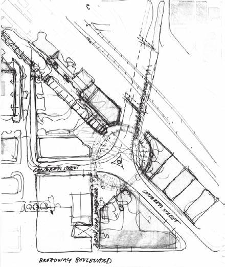
6 MASTERPLAN


7 Ground level Housing on top MASTERPLAN EVOLUTION - April & May MASTERPLAN Masterplan in June with two-way Boulevard configuration at Congress Street. Closed Toole Avenue as Pedestrian alle and solo East sidewalk through Underpass.

8 14 PLAZA CENTRO NORTH 01 THE UNDERPASS 02 THE PEDESTRIAN BRIDGE 04 THE STAIR 03 INTERSECTION 05 THE PASEO 06 THE SMALL PLAZA 11 ARCADE & LANDSCAPE 16 PLAZA CENTRO EAST 10 THE ALLEY 09 SIDEWALK 07 ARCADE & STREET PARKING 08 ENTRANCES 12 STREET EDGE CONFIGURATION 15 PLAZA CENTRO WEST SIDEWALK MASTERPLAN


9 14'-10" Section - Bridge Elevation from Core Intersection showing Primary Pedestrian Tunnel Entry at Lower Right VIERENDEEL TRUSS I-BEAM 14"x14" 14'-10" STEEL BEAM STEEL COLUMN The Link in the pedestrian Loop. Typical Section - Outer Structural Frame w/ Inner Secondary Skin and Cruciforn-Section Column Conceptual Sketch THE PEDESTRIAN BRIDGE

10 THE PEDESTRIAN BRIDGE


11 Gallery Space Artwork on the walls; Telling the Story of the Old Trolley. West sidewalk East sidewalk 4th AVE UNDERPASS


12 10'-7" LIGHT BOX 13'-10" LIGHT BOX BEAM; PAINTED SURFACE COLUMN; PAINTED SURFACE 20'-3" WHITE TILE IN STAINLESS STEELFRAME ETCHED IMAGE ON METAL, TBD BY ARTIST BLACK CONCRETE ETCHED CONCRETE; SAME AS STAIR BLACK CONCRETE ETCHED CONCRETE; SAME AS STAIR PAINTED SURFACE 1'-6" 1'-6" 4'-0" WEST SIDEWALK EAST SIDEWALK 4th AVE UNDERPASS


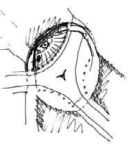
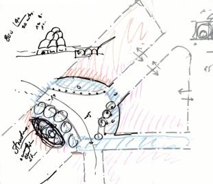
13 PLAZA CENTRO 4 th AVENUE Plan - Piazza-like stairs with water fountain and native planting garden Detail Plan of Pedestrian Bridge, Lift, Stair, Common Wall & Depot Plaza Park 0 2' 4' 8' Retaining Walls - Native Plantings Stair Elevation 02 1/4"=1'-0" Detail Plan & Sections/Elevations of Stair INTERSECTION: URBAN STAIR + FOUNTAIN 04 12/12/2006

 8'-0\" 3'-6\" SERVICE AND FIRE EXIT PLANTER FOR TREE 1/8\"=1'-0\" Section @ Broadway Boulevard F 1/8\"=1'-0\" TOOLE STREET 20'-0\" Section North of Underpass @ Sidewalk")

 - Opt With Curb 1/8\"=1'-0\" H PARKINGSTALL PAVING A ASPHALT ; DARK FOR GOOD MAINTENANCE DRIVE WAY PAVING B PAINTED CONCRETE; PATTERN TBD BY LOCAL ARTIST PARKINGSTALL 15'-0\" PARKINGSTALL")
14 Stage EQUIPMENT TROLLEY COORDINATE W HC PARKING Fire Alley (Along Railroad Track) 1/8"=1'-0" Waiting Area (Broadway Boulevard) C 1/8"=1'-0" Sidewalk West of 4th Avenue K 1/8"=1'-0" PROPERTY LINE TREES LANDSCAPING STREET-LIGHT/ SHORT POLE BUS PARKING Hotel Congress West of Tool Street K 1/8"=1'-0" O GUARDRAIL TREE COORDINATE TRANSITION W HOTEL CONGRESS Multi- Use Plaza Market/Fair PROPERTY LINE RETAIL RAILROAD TRACK 1'-0" 2'-0" 8'-0" 20'-0" SIDEWALK SHADING DEVICE 8'-0" BROADWAY BOULEVARD TREES LANDSCAPING STREET-LIGHT SIGNAGE STREET-LIGHT PEDESTRIAN ( Bollards with Lighting) 8'-0" 3'-6" SERVICE AND FIRE EXIT PLANTER FOR TREE 1/8"=1'-0" Broadway Boulevard F 1/8"=1'-0" TOOLE STREET 20'-0" Section North of Sidewalk East of 4th Avenue L 18'-0" CURB PARKING TREES LANDSCAPING STREET-LIGHT/ SHORT POLE PARKING METERS TRASH BIN LANDSCAPE 4'-0" Fire Alley (Along Railroad Track ) X'-X" SIDEWALK WALKWAY 1/8"=1'-0" Sidewalk West of Tool Street N 1/8"=1'-0" P EYELETS VERTICAL SHADING DEVICE 8'-0" POLES 4" DIAMETERS PAINTED IN VARIOUS COLORS 8'-0" CANOPIES 8'-0" FRAME LIGHTFIXTURES MISTERS OPTIONAL, BY SUBCONTRACTOR ANNUALLY RENEWED SHADING DEVICES TBD BY LOCAL ARTIST LIGHT FIXTURES 4'-0" 5'-6" 16'-0" TRAIN DEPOT/ RESTAURANT 10'-0" 26'-0" 16'-0" 8'-0" de (East Side of Congress Extension) - Opt With Curb 1/8"=1'-0" H PARKINGSTALL PAVING A ASPHALT ; DARK FOR GOOD MAINTENANCE DRIVE WAY PAVING B PAINTED CONCRETE; PATTERN TBD BY LOCAL ARTIST PARKINGSTALL 15'-0" PARKINGSTALL 18'-0" PAVING A ASPHALT ; DARK FOR GOOD MAINTENANCE DRIVE WAY 24 PAVING B PAINTED CONCRETE; PATTERN TBD BY LOCAL ARTIST NO PARKING MEETERS IN THIS ZOONE PARKING STALLS NUMBERED Detail Section and Elevation 10'-0" SIDEWALK / ARCADE SHADING DEVICE ENTRANCE LIGHT OPTION WITH TANDEM PARKING PARKING RETAIL East Side of Congress Extension - Opt With Curb 1/8"=1'-0" I Civic Stage PLAZA CENTRO NORTH: MULTI-USE CIVIC STAGE PARK/ PEDESTRIAN AREA PAVING C TREES PLANTERS FLAGPOLES BENCHES TRASH BIN 1/8"=1'-0" LOBBY HOUSING 5'-6" 8'-0" STREET FURNITURE TREES BENCHES TRASH BINS DRINKING FOUNTAINS SIGNAGE BICYCLE RACKS PARKING MEETERS STREET- LIGHT PAVING A ASPHALT ; DARK FOR GOOD MAINTENANCE Depot Plaza Multi-Use Urban Space 4'-0" 1'-0" KING ZOONE PARKINGSTALL 18 Q


15 1 2 Intimacy and Shade- A shaded intimate space in the middle of a major pedestrian path. Retail Paseo Outdoot-seating Retail THE PASEO


16 Meeting point- A waiting and a transit area for public transportation in the centre of the new Plaza Centro Development. The Plaza is a part of the Pedestrian Loop that goes all the way around the edges of the intersection. 4th Inter- Waiting Boot/ Trolley Paseo Waiting Boot/ Trolley Arcade THE SMALL PLAZA


17 Waiting 1area for Theatre Visitors. The fronyard of the Rialto Theatre. By only allowing for loading and emergency vehicles the Alley becomes the frontyard for the Thatre Rialto when their guests are lining up to get tickets for the show. The new development could have A Hole in the Wall Café or Fast food place for hungry queuers. hotel rialto alley hole in the wall THE ALLEY


18 retail arcade outdoor-seating retail congress intersection Arcade and Landscaped Edge with contained Outdoor-seating. Sun-brakes shade the Arcade from the strong West sun. ARCADE + LANDSCAPING


19 Urban Floor - Letting the sidewalk be level with the street and using the same paving on both surfaces creates a more generous sidewalk. Different shaped Bollards sepparates the sidewalk from the street- parking. The Bollards can be used for seating and Light and they can function as Meeting-points along the Street. At the wide parts of the Sidewalk tree grates out of laser-cut Steel are mixed up with the use of a softer material, Decomosed Granite or Sand to give a more varied natural feeling to the sidewalk but also to allow more water to the trees. SIDEWALK


20 The Gate- Garage Entrances are framed by the overlying building but set back from the face of the Arcade. The break in the arcade is easily perceived from a distance and indicates for the cars in the street where to enter. The building over head the entrance keeps the Streetedge intact. ENTRANCES The Vestibule


21 Short cuts - Freestanding Column at the corner of a building, the building steps back a little for the pedestrian, letting the pedestrian step on the nicer carpet underneath the building, within the footprint of the building/ the private. Loosening up the edge between private and public. Typical Corner Retail Store Conditions in Tucson BUILDING EDGES


22 1. Arcade, 4th Avenue Tucson, AZ Arcade at Storefront next to Street-parking, shaded storefront/ entrance, possibility for seating in-between indoors and outdoors. ARCADE + STREETPARKING


23 Multi-Use Plaza 4th avenue Intersection Plaza Centro Development East Elevation New Extended Congress St Plaza Centro Development Congress St Hotel Congress West Elevation New Extended Congress St 14 PLAZA CENTRO EAST / 15 PLAZA CENTRO WEST - Mixed Use Development Sites


24 14 PLAZA CENTRO EAST / 15 PLAZA CENTRO WEST - Mixed Use Development Sites

25 14 PLAZA CENTRO EAST / 15 PLAZA CENTRO WEST - Mixed Use Development Sites
4.9 Mendocino Avenue Corridor Plan Design Guidelines
 4.9 Mendocino Avenue Corridor Plan Design Guidelines The Mendocino Avenue Corridor Plan addresses the area between College Avenue and Steele Lane. Mendocino Avenue is a busy arterial that runs parallel
Figure Example of out door dining in the public right-of-way.
 Section 2 Core Area Goal 2.2.1 To maintain and enhance the character of existing streets in the Downtown Area. Character Figure 2.2.1 Example of out door dining in the public right-of-way. A. Provide street
Buildings may be set back to create small plazas provided that these setbacks do not substantially disrupt the street wall s continuity.
 6-22 Community Design Street Walls and Street-front Setbacks The siting of buildings will play a critical role in establishing the character and sense of place for the District. Siting buildings at the
Chapter 4: Jordan Road Character District
 4: Jordan Road Character District 4.1 Introduction The Jordan Road character district encompasses much of the former Jordan orchard and farmstead, which was a significant part of Sedona s history. The
BUSINESS DISTRICT DESIGN GUIDELINES
 Des Plaines, Illinois Prepared for the City of Des Plaines by: The Lakota Group Laurie Marston, AICP March 2005 Section 5: Streetscape Elements Business District Design Guidelines STREETSCAPE ELEMENTS
appendix and street interface guidelines
 appendix five: building and street interface guidelines appendix 5 building and street interface guidelines BOULEVARDS Boulevards are generally characterized by higher levels of traffic movement at higher
SFMTA PHELAN LOOP AND PUBLIC PLAZA PHELAN OCEAN AVENUE
 SFMTA Municipal Transportation Agency Image: a bus in front of the Palace of the Legion of honor SFMTA PHELAN LOOP AND PUBLIC PLAZA PHELAN AVENUE @ OCEAN AVENUE Community Meeting May 23, 2012 San Francisco,
Streetscape Patterns. Design Guidelines, Ridgewood Village Center Historic District, Ridgewood, N.J. page 20
 North Broad Street has a unique streetscape pattern with broad curving street, tight enclosure on the east side with attached commercial buildings aligned with the sidewalk, and landscaped open space on
CENTERS AND CORRIDORS
 INITIAL DESIGN STANDARDS AND GUIDELINES for CENTERS AND CORRIDORS City of Spokane Planning Services Third Floor, City Hall 808 W. Spokane Falls Blvd. Spokane, WA 99201-3329 (509) 625-6300 www.spokaneplanning.org
The Village. Chapter 3. Mixed Use Development Plan SPECIFIC PLAN
 The Village SPECIFIC PLAN Chapter 3 3.1 INTRODUCTION 3.1.1 Purpose This Chapter describes the development regulations applicable to the Mixed-Use and Transit Center Planning Areas. These form-based regulations
Chapter 5: Mixed Use Neighborhood Character District
 5: Mixed Use Neighborhood Character District 5.1 Introduction The Mixed Use Neighborhood character district acts as a transition or bridge between the State Route 89A District s commercial area to the
FLORIN ROAD CORRIDOR Site Plan and Design Review Guidelines Checklist
 FLORIN ROAD CORRIDOR Site Plan and Design Review Guidelines Checklist Applicant s Name: Project Address: Phone: Email: Applicant shall fill out the design guidelines checklist for all guidelines applicable
VEHICULAR AND PEDESTRIAN CIRCULATION
 This perspective sketch communicates the intended character and quality of a proposed streetscape design. Locate benches near a major intersection where people tend to gather. Seating and lighting provide
Carlsbad Village Redevelopment Concept Summary of Features
 Carlsbad Village Redevelopment Concept Summary of Features Calthorpe Associates November 5, 2003 The Redevelopment Concept illustrates a vision for the future of Carlsbad Village. The overall vision of
Cleveland Park Streetscape and Drainage Improvement Project 1
 Cleveland Park Streetscape and Drainage Improvement Project 1 Urban Context Washington, D.C. Connecticut Avenue Cleveland Park Streetscape and Drainage Improvement Project 2 Neighborhood Context Contributing
Pine Avenue Improvement Project
 Seaside Way to ocean Boulevard ocean Boulevard to 7 th Street 7 th Street to anaheim Street L O ng BeACh DeveLOpment ServiC e S Building a Better long Beach Pine Avenue Improvement Project Seaside Way
Maplewood Avenue Downtown Complete Street Project
 Maplewood Avenue Downtown Complete Street Project Second Public Meeting January 24, 2018 Welcome and Introduction of Project Team City Planning and Public Works Staff City of Portsmouth Juliet Walker Planning
4.0 Design Guidelines For The Village Centre. South fields Community Architectural Design Guidelines Town of Caledon
 4.0 Design Guidelines For The Village Centre 4.0 Design Guidelines for the Village Centre The Village Centre is the focal point of the entire South Fields Community and is designed as a traditional commercial
Division VI Community Mixed Use (CMU) Architectural Guidelines and Standards
 Architectural Guidelines and Standards") Division VI 18.40.800 Community Mixed Use (CMU) Architectural Guidelines and Standards 18.40.810 Guidelines The goals of the Comprehensive Plan include a focus on pedestrian safety, amenities and aesthetics
Division VI 18.40.800 Community Mixed Use (CMU) Architectural Guidelines and Standards 18.40.810 Guidelines The goals of the Comprehensive Plan include a focus on pedestrian safety, amenities and aesthetics
ELK GROVE TOWN CENTER DESIGN GUIDELINES
 ......... ELK GROVE TOWN CENTER DESIGN GUIDELINES LAGUNA RIDGE SPECIFIC PLAN... June 2008 ............ DESIGN GUIDELINES Table of Contents Contents Section A: Town Center Overview...1 A.1. Purpose and
STREETSCAPE IMPROVEMENTS - RECOMMENDATIONS
 STREETSCAPE IMPROVEMENTS - RECOMMENDATIONS Figure 4.3.1- A map of all of the recommended streetscape improvements. The key component of downtown s public realm, apart from its public spaces, is its street
SECTION TWO: Overall Design Guidelines
 SECTION TWO: Overall Design Guidelines This section provides overall design principles and guidelines for the Gardnerville Mixed-use Overlay. They provide criteria for mixed-use places consisting of residential,
VILLAGE OF SKOKIE Design Guidelines for Mixed-Use Districts NX Neighborhood Mixed-Use TX Transit Mixed-Use CX Core Mixed-Use
 VILLAGE OF SKOKIE Design Guidelines for Mixed-Use Districts NX Neighborhood Mixed-Use TX Transit Mixed-Use CX Core Mixed-Use TABLE OF CONTENTS CHAPTER 1 SITE DESIGN Purpose 1 CHAPTER 2 SITE DESIGN Streetscape
2. Form and Character. 2.1 Introduction. 2.2 The Downtown Addition Plan. 2.1 Introduction
 2.1 Introduction 2.1 Introduction This section of the Specific Plan describes and illustrates the desired form, character and uses of the Downtown Addition and explains the underlying design principles.
DRAFT. 10% Common Open Space
 % OF CHARLOTTE IS CATEGORIZED AS A. LAND USES : Placeholder map displaying location of Place Type GOALS: Accommodate XX% of future growth. Provide a concentration of primarily commercial and civic activity
STAFF BRIEF. Project: 2016-COA-356 Meeting: September 8, th Street Oxford Hotel
 Community Planning and Development Denver Landmark Preservation 20 West Colfax, Dept. 205 p: (720)-865-2709 f: (720)-865-3050 www.denvergov.org/preservation STAFF BRIEF E-Mail: landmark@denvergov.org This
Jewel. Platte. of the. Plattsmouth Main Street Landscape Architecture by HDR
 Jewel of the Platte Plattsmouth Main Street Landscape Architecture by HDR Plattsmouth, Nebraska is a historic community of 6,500 residents located along the west bank of the Missouri River, just south
Landscape and Streetscape Design 2.5
 Landscape and Streetscape Design 2.5 2.5.1 Goals 2.5.2 Planting 2.5.3 Sidewalks and Pavement 2.5.4 Furnishings 2.5.5 Walls 2.5.6 Lighting 2.5.7 Stormwater 2.5.8 Street Cross Sections 2.5 LANDSCAPE AND
3.13. Development Guidelines
 3.3 Landscaping Elements Landscaping should be used to frame and soften structures, define site functions, enhance the quality of the environment, and screen undesirable views. Safety, environmental impacts,
EcoVerde MADISON TO DOWNTOWN TO BEACH. Legend Highway Major Connection Major Street Local Street Proposed Access. Response to Tropicana Field RFP
 EcoVerde TO BEACH 275 16th Street North 16th Street South 13th Street North 13th Street South 11th Street North 11th Street South 1st Avenue North Central Avenue 1st Avenue South TO DOWNTOWN 2nd Avenue
FROM DUPONT CIRCLE NORTH TO CALIFORNIA STREET, NW. Welcome!
 FROM DUPONT CIRCLE NORTH TO CALIFORNIA STREET, NW Welcome! Meeting Agenda 6:00 PM Open House 6:30 PM Presentation 7:00 PM Open House / Q&A at the Boards Project Design Team Connecticut Avenue, NW Project
Burlington Enhancement Plan
 Burlington Enhancement Plan Community Presenta/on Burlington Residents Association East Tennessee Community Design Center The ETCDC is a non-profit that provides low cost, conceptual architectural and
Wayfinding. North Gateway: Integrate a vertical gateway marker on the west side of Ward Street at the south corner of Vernon Street.
 3.3.6.2 Wayfinding Existing Conditions Wayfinding signage is important to direct visitors and tourists to different locations in the downtown. A significant part of the wayfinding signage in the downtown
Design Guidelines. Roosevelt. Mike Podowski DPD Design Guidelines Ordinance ATT 13 August 13, 2012 Version #1
 Roosevelt Design Guidelines The Roosevelt Neighborhood Design Guidelines apply within the Neighborhood Boundary. Map 1 2 Map 2 3 Map 3 4 CS1 Natural Systems and Site Features Citywide Guideline: Use natural
Introduction Plan Overview Performance and Development Standards Design Guidelines
 TABLE OF CONTENTS Introduction... 6-11 Plan Overview... 6-19 Performance and Development Standards... 6-27 Design Guidelines... 6-33 6-9 6-10 This page is intentionally left blank. 6-11 INTRODUCTION This
Streets Vision
 streets 86 2.9 Vision : The Most Prevalent and Important Public Spaces Fixed routes of human travel have served as corridors for commerce and places for human interaction from the earliest trails and foot
Community Mixed Use Zone Districts (CMU)
") 18.28.500 Community Mixed Use Zone Districts (CMU) The Community Mixed Use Zone Districts (CMU) are intended to help implement the land use goals and strategies found in the Golden Vision 2030 values,
18.28.500 Community Mixed Use Zone Districts (CMU) The Community Mixed Use Zone Districts (CMU) are intended to help implement the land use goals and strategies found in the Golden Vision 2030 values,
NOVEMBER 2016 AARP IN ST. LOUIS & CITIZENS FOR MODERN TRANSIT PLACEMAKING STRATEGIES FOR ST. LOUIS TRANSIT DRAFT
 NOVEMBER 2016 AARP IN ST. LOUIS & CITIZENS FOR MODERN TRANSIT PLACEMAKING STRATEGIES FOR ST. LOUIS TRANSIT DRAFT SECTION 3 RECOMMENDATIONS AARP IN ST. LOUIS + CMT + ARCTURIS + THE INNIS GROUP 37 SECTION
City of Redlands Architectural Guidelines for Non-Residential Development
 14. Building articulation shall be included in the design of building, in order to create a formal entry statement. Avoid this Do this Page 11 15. Give special attention to creating pedestrian scale and
Policies and Code Intent Sections Related to Town Center
 Policies and Code Intent Sections Related to Town Center The Town Center Vision is scattered throughout the Comprehensive Plan, development code and the 1994 Town Center Plan. What follows are sections
COMPLETE GREEN STREET CHECKLIST
 COMPLETE GREEN STREET CHECKLIST This document was developed to dissect the structure of an urban street and explore opportunities to make our streets more complete while also integrating green street strategies.
New Park / Entry Court & Plaza Concept Design
 New Park / Entry Court & Plaza Concept Design The SECC Public realm is proposed to have a focus on health, wellness, and community and that site users will include patrons of the neighbourhood. The block
Discovering Public Space: An Investigation of Portland s Civic Realm
 Discovering Public Space: An Investigation of Portland s Civic Realm Irie Searcy Architectural Programming Seminar J. Von Bargen, Fall 2008 December 8, 2008 Discovering Public Space: An Investigation of
The McCoppin Hub. Boor Bridges Architecture
 The McCoppin Hub Boor Bridges Architecture Comments on the Original Concept: - Unify - explore means of making the layout feel less broken up and compartmentalized. Suggestions include: remove one level
Planning Board Hearing October 20th, 2016
 Planning Board Hearing October 0th, 06 Developer: Real Estate Management & Leasing: Architect: Transportation Engineers: Landscape Architect: Civil Engineer: THE ARSENAL PROJECT Planning Board AGENDA Introduction
ROME WATERFRONT VILLAGE PROJECT NARRATIVE January 25, 2018
 January 25, 2018 The Rome Waterfront Village project is intended to foster the revitalization of the area between South James Street and Erie Boulevard north of the Erie Canal as well as improve public
Metro. Activity Center Design Guidelines. Recommendations For Developing Focused, Mixed-Use Commercial/Residential Centers
 Metro Activity Center Design Guidelines Recommendations For Developing Focused, Mixed-Use Commercial/Residential Centers Metro Activity Centers What is a MAC? Legacy, the adopted guide for the future growth
EXISTING CONDITIONS 41. Existing Conditions
 EXISTING CONDITIONS 41 Existing Conditions The Existing Analysis phase of the planning process involved a study of the existing conditions on the campus in order to identify key planning issues to be addressed
Sidewalks Street Lights
 Boston Complete Streets Guidelines 013 Boston Transportation Department Sidewalks Introduction 17 Sidewalk Design Principles 18 Sidewalk Zones 0 Sidewalk Zones Widths Preferred and Minimum Widths for Sidewalk
Table of Contents. Elm Avenue Improvement Plan City of Waco, Texas. Introduction 1. Existing Context 1 Figure 1 2.
 Table of Contents Introduction 1 Existing Context 1 Figure 1 2 Plan Guidelines 3 Future Urban Form 4 The West-End 4 Main Street 6 The East-End 7 Figure 2 9 Public Improvement Recommendations 7 General
EXISTING VEHICULAR & PEDESTRIAN CIRCULATION
 46 EXISTING CONDITIONS EXISTING VEHICULAR & PEDESTRIAN CIRCULATION Vehicular and pedestrian circulation patterns are illustrated on this graphic. Campus entry points and major vehicular circulation routes
SUBJECT: PREDEVELOPMENT PLAN REVIEW OF PROJECT LOCATED AT E. COLORADO BOULEVARD (PASEO COLORADO)
") TO: FROM: Honorable Mayor and City Council Planning & Community Development Department SUBJECT: PREDEVELOPMENT PLAN REVIEW OF PROJECT LOCATED AT 260-400 E. COLORADO BOULEVARD (PASEO COLORADO) RECOMMENDATION:
TO: FROM: Honorable Mayor and City Council Planning & Community Development Department SUBJECT: PREDEVELOPMENT PLAN REVIEW OF PROJECT LOCATED AT 260-400 E. COLORADO BOULEVARD (PASEO COLORADO) RECOMMENDATION:
Gateway commercial MIXED USE MASTER SITE PLAN. CITILAND AIrDRIE GATEWAY VENTURE INC. airdrie GATEWAY COMMERCE CENTRE. airdrie, ALBERTA FEBRUARY 2012
 Gateway commercial MIXED USE MASTER SITE PLAN 1914 CENTRE STREET NORTH CALGARY, AB CANADA T2E 2S8 T. 403.264.7177 F. 403.264-7175 WWW.CITILAND.CA CITILAND AIrDRIE GATEWAY VENTURE INC. airdrie GATEWAY COMMERCE
Community Design Plan
 Gardena General Plan 2006 Authority While the is not a required element of a General Plan, it is included because improving the community appearance and image is paramount to the overall quality of life
A Vibrant Downtown. Chapter 5 Cary Public Art Opportunities 31
 A Vibrant Downtown Cary s vision for Downtown is a unique, vibrant, dynamic, pedestrian friendly location; a regional destination and a place to live, work, and recreate, according to the 2001 Town Center
FRUITVALE TRANSIT VILLAGE (Phase 2) Residential Project
 Residential Project") FRUITVALE TRANSIT VILLAGE (Phase 2) Residential Project DEVELOPER: SIGNATURE PROPERTIES ARCHITECT: HKIT ARCHITECTS April 23, 2010 TABLE OF CONTENTS 3 Vision 4 Description of Site 5 Guiding Concepts 6
FRUITVALE TRANSIT VILLAGE (Phase 2) Residential Project DEVELOPER: SIGNATURE PROPERTIES ARCHITECT: HKIT ARCHITECTS April 23, 2010 TABLE OF CONTENTS 3 Vision 4 Description of Site 5 Guiding Concepts 6
West Dennis Center: Bass River to Old Main Street. West Dennis Business District: Old Main Street to Dennis Commons
 West Dennis Center: Bass River to Old Main Street West Dennis Business District: Old Main Street to Dennis Commons Dennisport Center: Dennis Commons to Division Street Main Street Project Goals Project
(DC1) Direct Development Control Provision DC1 Area 4
 Direct Development Control Provision DC1 Area 4") . General Purpose (DC) Direct Development Control Provision DC Area 4 The purpose of this Provision is to provide for an area of commercial office employment and residential development in support of the
. General Purpose (DC) Direct Development Control Provision DC Area 4 The purpose of this Provision is to provide for an area of commercial office employment and residential development in support of the
City of Lafayette Staff Report Design Review Commission
 City of Lafayette Staff Report Design Review Commission Meeting Date: February 13, 2017 Staff: Subject: Niroop K. Srivatsa DR13-14DDII Lennar Homes (Applicant), C-Zoning: Request for: (1) Review of Phase
The Village of Shirlington
 The Village of Shirlington Suburban Smart Growth Without Rail Transit July 2018 Agenda History (1940 to present) Attributes and Outcomes Lessons Learned Setting the Stage Arlington County Arlington is
RHBL 7325 ENVIRONMENTAL ANALYSIS. By: Whitney Musick
 RHBL 7325 ENVIRONMENTAL ANALYSIS By: Whitney Musick UALR s Ottenheimer Library Photo Credit: http://www.flickr.com/photos/30091470@n08/4565851613/ Background Description Ottenheimer Library is centrally
400 West Georgia Street Urban Design Panel. Public Realm
 400 West Georgia Street Urban Design Panel Public Realm Public Benefits The main benefit in regards to the proposed development at 400 West Georgia Street will be to increase density of Commercial Office
Clairtrell Area Context Plan
 Clairtrell Area Context Plan March 2005 Urban Development Services City Planning Contents 1. Introduction... 4 2. Development Structure... 6 2.1 Streets... 7 2.1.1 Sheppard Avenue and Bayview Avenue...
Architectural Review Board Report
 Architectural Review Board Report To: From: CC: Subject: Architectural Review Board Architectural Review Board Meeting: May 21, 2018 Agenda Item: 8-A Grace Page, Senior Planner Stephanie Reich, AIA, LEED
PIKE PINE RENAISSANCE: ACT ONE. October 19, 2017
 PIKE PINE RENAISSANCE: ACT ONE October 19, 2017 WATERFRONT SEATTLE PROGRAM PROJECT INTRODUCTION Pike and Pine streets, between First and Melrose avenues Pedestrian and streetscape improvements Budget:
Sierra Springs Regional Commercial Master Site Plan Airdrie, Alberta Hopewell Development Corporation Project No May 26, 2010
 Sierra Springs Regional Commercial Master Site Plan Airdrie, Alberta Hopewell Development Corporation Project No. 205-077 May 26, 2010 TABLE OF CONTENTS Purpose... 2 Master Site Plan Guidelines... 3 Overall
23 July Sunshine Alley Design Project Open House Exhibits
 23 July Sunshine Alley Design Project Open House Exhibits Sunshine Alley Design Workshops were conducted over 2 evenings in late February and involved 57 people who had signed up on the Town s website
VISION AND GUIDING DESIGN PRINCIPLES
 pleasure point commercial corridor VISION AND GUIDING DESIGN PRINCIPLES Public Draft November 26, 2018 County of Santa Cruz with assistance from MIG CONTENTS PART I: INTRODUCTION AND VISION... 3 Community
Conceptual Design. Main Street Enhancement and Extension Project. Bothell, Washington. June 11, 2009
 Conceptual Design Main Street Enhancement and Extension Project Bothell, Washington June 11, 2009 Berger/ABAM Engineers and Cascade Design Collaborative, Inc For Main Street Bothell to succeed it must
PLANNING AND DESIGN GUIDELINES FOR BLOCK C OF THE MT. DIABLO REDEVELOPMENT PROJECT AREA Adopted by Design Review Commission February 4, 2004
 PLANNING AND DESIGN GUIDELINES FOR BLOCK C OF THE MT. DIABLO REDEVELOPMENT PROJECT AREA Adopted by Design Review Commission February 4, 2004 The Walnut Creek Redevelopment Agency has an adopted plan for
Call for Artists Gateway Island Ashland Oregon Requests for Qualifications (RFQ)
") Call for Artists Gateway Island Ashland Oregon Requests for Qualifications (RFQ) The Project The Ashland Public Art Commission (PAC) seeks an artist, or artist team, to develop a site specific, permanent,
Call for Artists Gateway Island Ashland Oregon Requests for Qualifications (RFQ) The Project The Ashland Public Art Commission (PAC) seeks an artist, or artist team, to develop a site specific, permanent,
Revitalizing Urban Main Streets
 MIT OpenCourseWare http://ocw.mit.edu Spring 2009 For information about citing these materials or our Terms of Use, visit: http://ocw.mit.edu/terms. Team 1: Traffic/Pedestrian Activity/Public Transportation
The open space system should provide connective elements, relate to natural resources, and enhance the suburban character of the landscape..
 The open space system should provide connective elements, relate to natural resources, and enhance the suburban character of the landscape.. Mixed-use and infill development should maintain or enhance
V. Gateways GATEWAYS / V-1
 V. GATEWAYS / V-1 Many of Chesapeake s gateways are located on highways and call for bold and attractive designs that motorists can understand, appreciate, and enjoy. can also take the form of natural
Planned Development Application 1450 Sherman Avenue Evanston, IL Responses to DAPR Meeting I City Staff Comments
 Planned Development Application 1450 Sherman Avenue Evanston, IL 60201 Responses to DAPR Meeting I City Staff Comments Questions asked by City Staff during DAPR Meeting I on 8/26/2017 have been addressed
Forest Hills Improvement Initiative A Partnership for Building a Better Community. Use & Design Guidelines September 23, 2008
 Forest Hills Improvement Initiative A Partnership for Building a Better Community City of Boston Thomas M. Menino, Mayor Emerging Community Vision p. 2 Site Use & Design Guidelines p. 3 to 21 Arborway
WEST LOOP DESIGN GUIDELINES CHECKLIST
 WEST LOOP DESIGN GUIDELINES CHECKLIST Section 1.0 General Strategies 1.1 DESIGN EXCELLENCE: ENCOURAGE HIGH QUALITY AND INNOVATIVE DESIGN OF NEW BUILDINGS WITHIN THE WEST LOOP WITHOUT BEING PRESCRIPTIVE
Chapter 6--Urban Design
 6.1 Introduction... 6-1 6.1.1 Background & Scope... 6-1 6.1.2 Relationship to State Law... 6-2 6.1.3 Relationship to Other General Plan Chapters... 6-2 6.2 Guiding Principles... 6-2 6.3 Urban Design Guidelines...
Bayshore Boulevard Home Improvement District Design Guidelines
 Bayshore Boulevard Home Improvement District Design Guidelines guidelines for New construction projects and major alterations IN the bayshore boulevard home improvement special use DISTRICT SAN FRANCISCO
Millbrae TOD #2 Project Analysis
 Millbrae TOD #2 Project Analysis Project Description A Site Development Permit and Conditional Use Permit are proposed to allow for a mixed-use transitoriented development on approximately 9 Acres located
Sub Area 2: Downtown Overland Park
 Downtown 132 2.12 encompasses over 600 acres and extends between 71st Street and 87 th Street including Downtown Overland Park. The area is home to several individual historic sites and structures, including
GREENING THE BOULEVARD Master Plan Concepts for Venice Boulevard between Lincoln and Sawtelle
 GREENING THE BOULEVARD Katherine Spitz Associates Inc. 4212½ Glencoe Avenue Marina Del Rey, CA 90292 310 574 4460 Fax 574 4462 January 2008 Table of Contents Overview Proposed Design Improvements Illustration
Downtown Papillion. Concepts for the Enhancement and Growth of Papillion s Traditional Town Center
 Downtown Papillion Concepts for the Enhancement and Growth of Papillion s Traditional Town Center Developed for the City of Papillion by RDG Planning & Design T raditional downtown districts occupy a particular
ZONING: C-1-T. PARKING PROVIDED On-Site Valet 51 On-Site Holman Dedicated 14 Off-Site Valet TOTAL 113. (Mechanical Lifts)
") BUILDING CODE ANALYSIS REFERENCE CODES 0 CALIFORNIA BUILDING CODE 0 INTERNATIONAL BUILDING CODE OCCUPANCY USE AND CLASSIFICATION SECTION 0 & THE PROPOSED BUILDING CONSISTS OF STORIES OF OVER STORY OF VALET
BUILDING CODE ANALYSIS REFERENCE CODES 0 CALIFORNIA BUILDING CODE 0 INTERNATIONAL BUILDING CODE OCCUPANCY USE AND CLASSIFICATION SECTION 0 & THE PROPOSED BUILDING CONSISTS OF STORIES OF OVER STORY OF VALET
PROPOSED REDEVELOPMENT OF THE GLEN ABBEY GOLF CLUB. STREETSCAPE DESIGN STUDY (excerpt from the Urban Design Brief) TOWN OF OAKVILLE.
 TOWN OF OAKVILLE.") PROPOSED REDEVELOPMENT OF THE GLEN ABBEY GOLF CLUB STREETSCAPE DESIGN STUDY (excerpt from the Urban Design Brief) TOWN OF OAKVILLE OCTOBER, 2016 for 2.4.2 STREETS Streets are the single largest component
PROPOSED REDEVELOPMENT OF THE GLEN ABBEY GOLF CLUB STREETSCAPE DESIGN STUDY (excerpt from the Urban Design Brief) TOWN OF OAKVILLE OCTOBER, 2016 for 2.4.2 STREETS Streets are the single largest component
PUBLIC RIGHT-OF-WAY IN THIS CHAPTER PUBLIC REALM
 PUBLIC RIGHT-OF-WAY This section provides design guidelines for improvements in the public right-of-way. The public right-of-way refers to streets, sidewalks, non-vehicular thoroughfares, parks and greenways
Chapter 2, Section C: Urban Design and Visual Resources A. INTRODUCTION
 Chapter 2, Section C: Urban Design and Visual Resources A. INTRODUCTION This attachment considers the potential of the proposed East River Waterfront Access Project at Peck Slip to effect urban design
TOWN CENTER DESIGN STANDARDS FOR THE CITY OF. August, MOUNTLAKE TERRACE TOWN CENTER DESIGN STANDARDS August,
 TOWN CENTER DESIGN STANDARDS FOR THE CITY OF MOUNTLAKE TERRACE August, 2008 MOUNTLAKE TERRACE TOWN CENTER DESIGN STANDARDS August, 2008 1 TABLE OF CONTENTS Introduction...3 Design Site Design...4 Pedestrian
PROPOSED WATERFRONT DISTRICT DESIGN STANDARDS
 PROPOSED WATERFRONT DISTRICT DESIGN STANDARDS 20.25 DESIGN REVIEW. 20.25.080 WATERFRONT DISTRICT A. Purpose. This section is intended to implement The Waterfront District Subarea Plan by: 1. Creating a
SOUTH UNIVERSITY Street Design Setting a Direction for Schematic Design
 1 SOUTH UNIVERSITY Street Design Setting a Direction for Schematic Design Meeting Agenda 2 1. Project Scope 2. Design Direction 3. Design Details 4. Schedule and Construction Logistics 3 SOUTH UNIVERSITY
CHAPTER 5 Public Realm Improvements
 5.1 OVERVIEW This chapter focuses on the public realm, that is, spaces within and directly adjacent to public rights-of-way (ROWs), including streets, Oso Creek, the rail corridor, and the freeway edge.
Broadway Avenue Streetscape Project City of Albert Lea. Streetscape Design Committee Meeting October 29, 2012
 Broadway Avenue Streetscape Project City of Albert Lea Streetscape Design Committee Meeting October 29, 2012 1 Presentation Outline Street Widths, Sidewalk Widths and Bump-Out Configuration Decorative
Lambeth Main Street Streetscape Improvements
 Lambeth Main Street Streetscape Improvements Open House October 5th, 2017 Agenda 1. Introduction 2. Project Background 3. Context 4. Project Objectives 5. Design Principles & Approach 6. Streetscape Design
WATERFRONT DISTRICT DESIGN STANDARDS
 WATERFRONT DISTRICT DESIGN STANDARDS 20.25.080 WATERFRONT DISTRICT A. Purpose. This section is intended to implement The Waterfront District Subarea Plan by: 1. Creating a safe, vibrant mixed-use urban
Chapter 14 Streetscape Improvements
 This chapter presents streetscape design concepts for key streets and gateways in the Downtown Specific Plan area. This chapter is organized as follows: 14 Streetscape Improvements 14.1 Streetscape Treatments
Bethlehem Pike Streetscape Master Plan
 Bethlehem Pike Streetscape Master Plan Prepared for Springfield Township October 2008 By Michael Baker Jr., Inc. Carter Van Dyke Associates Table of Contents 1. Introduction 3 2. General Corridor Wide
Exhibit B Pacific Palisades Commercial Village Redevelopment Project Project Description
 Executive Summary Exhibit B Pacific Palisades Commercial Village Redevelopment Project Project Description Palisades Village Co., LLC and CAH Acquisition Co. V, LLC, wholly owned subsidiaries of Caruso
1. General Purpose. 3. Uses
 1. General Purpose The purpose of this DC1 Provision is to facilitate the development of a pedestrian friendly Community Commercial Centre that may accommodate a range of commercial, residential, office,
Town Center Design Guidelines
 Adopted by City Council on September 18, 2018 Design Theme The Draper Town Center Design Theme is defined as encompassing those architectural design styles that were prevalent in the construction of civic
chapter DESIGN GUIDELINES NEW RIVER MASTER PLAN REPORT
 chapter DESIGN GUIDELINES NEW RIVER MASTER PLAN REPORT .76 DESIGN GUIDELINES An Overview design guidelines NEW RIVER MASTER PLAN Design Guidelines can transform the image of a city. Specific, design-based