West Jasper Place Outline Plan
|
|
|
- Reynold Stephens
- 5 years ago
- Views:
Transcription
1 West Jasper Place Outline Plan Office Consolidation, June 2006 Prepared by: Planning and Policy Services Branch Planning and Development Department City of Edmonton The West Jasper Place Outline Plan, was approved by resolution by Council in May In June 2006, this document was consolidated. Editor s Note: This is an office consolidation edition of the West Jasper Place Outline Plan, as approved by City Council on May 18, For the sake of clarity, new maps and a standardized format were utilized in this Plan. All names of City departments have been standardized to reflect their present titles. Furthermore, all reasonable attempts were made to accurately reflect the original document. In case of uncertainty, the reader is advised to consult the original document, available at the office of the City Clerk. City of Edmonton Planning and Development Department
2
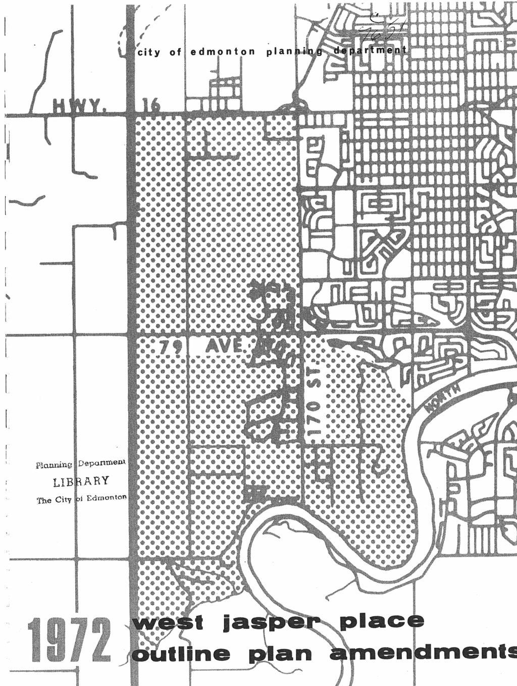
3 WEST JASPER PLACE OUTLINE PLAN AMENDMENTS 1972 City of Edmonton, Planning Department
4 City Council, at its meeting of May 18th, 1972, considered Public Affairs Committee Report #15 (Item 1.A) West Jasper Place Outline Plan Amendments when " all recommendations were concurred in...": That Council concur with the recommendations of the Commission Board which were presented to Council on April 10th (copy attached), with the following amendments: 1) Alignment of the West Ring Road That the present alignment of the west ring road shall be considered the west planning boundary of the West Jasper Place Outline Plan area. The determination of the delineation of a ring road, or whether in fact there will be a ring road, is beyond the purview of the Committee and the recommendation regarding boundary is not to be taken as in any way being a determining factor, as to either location or construction of such a facility. 2) 170 Street extension through the Golf and Country Club That 170 Street be not extended through the Country Club golf course nor in the ravine traversing the golf course to the river and that a study be made to determine whether the traffic warrants a river crossing from the West Jasper Place Outline Plan area through Terwillegar Park to the Riverbend-Terwillegar Heights Outline Plan area, and that the study include alternatives. 3) 78 Avenue extension through Patricia Heights That the decision on a crossing in the vicinity of 78 Avenue should be resolved by discussion between the Administration and the residents of Patricia Heights at the time that further subdivision plans for the area south of Patricia Heights are being processed for approval. 4) North Boundary - Mr. R. Rosen That the north planning boundary of the West Jasper Place Outline Plan be confirmed as indicated on the maps shown in the 1972 Outline Plan Amendments. 5) Neighborhood Outline Plan Concept - Mr. F. Sagan That since the neighborhood outline plan concept was first delineated in the B.A.C.M. Ltd. agreement, the Administration has been proceeding on this basis and in the Committee ' s view should continue with this -principle.
5 COMMISSION BOARD REPORT D.2.c. West Jasper Place Outline Plan Amendments Recommendation: " That Council approve the West Jasper Place Outline Plan Amendments 1972 as supported by the Municipal Planning Commission. (CB) Enclosed is a report from the Municipal Planning Commission recommending: 1. That the West Jasper Place Outline Plan Density Distribution Supplement Report be supported and submitted to Council for approval as an addendum to the approved West Jasper Place Outline Plan. 2. That prior to approval of subdivision and/or detailed zoning, the developers owning land within the Outline Plan area shall be required to enter into development agreements with the City. 3. That the Revised Schematic General Structure Plan be approved as an addendum to the approved West Jasper Place Outline Plan. 4. That where further development affects land fragmented by different ownership, subdivision plans shall be prepared on a neighborhood basis utilizing the replotting scheme method and developers' agreements. 5. That provision be made in each neighborhood for the accommodation of a minimum of 5 per cent of the population of that neighborhood in public housing as defined by City Council. 6. That mobile home developments may be considered in the Outline Plan provided that they are designed for integration into the comprehensive development of the plan. 7. That an intermediate or district level of shopping facilities he considered in the plan where it can be shown that they are necessary and desirable and will not adversely affect the intent of the Outline Plan. Commission Board has considered the report and recommends its approval by Council. COMMISSION BOARD Chief Commissioner P.F. Bargen (Chairman) Mayor I.G. Dent Commissioner S.J. Hampton Commissioner G.S. Hughes Commissioner T.E. Adams (Enclosure) April 10, 1972
6 1. INTRODUCTION On March 24th, 1969, the West Jasper Place Outline Plan was approved in principle by City Council. Development has subsequently proceeded in general conformity to that plan but a number of adjustments and revisions have been found necessary in order to accommodate improvements to the design of certain elements: viz the arterial road network, the school distribution pattern, the commercial distribution pattern. Also changes in the approach to development throughout the City at large have necessitated that the plan contain new provisions regarding public facilities and the implications on public land needs. Further, a general trend towards higher density residential development as a means of providing more variety and economy in housing required that the plan be reviewed and brought up to the current density levels being applied in all other outline plan areas in the City. The following text represents a consolidation of a summary of the original Outline Plan report with these amendments and is intended to supersede the original document which is now out of print. A considerable amount of detail contained in the original document has been omitted since much of it has been incorporated into City policy, regulations and bylaws. However, copies of the original Outline Plan may be reviewed at the Public Library or the Planning and Development Department, if desired. Due to the complex and sometimes changing planning requirements of the developing areas, and the practical difficulties of containing all such information in a report of this nature, it is strongly urged that any person wishing to undertake development in the Outline Plan area, consult with the Planning and Development Department at an early stage in the preparation of planning schemes.
7
8 2. THE CONCEPT A. PRINCIPLES AND OBJECTIVES The following are the principles and objectives which were established to guide the evolution and development of the Planning Scheme for West Jasper Place. These principles and objectives were determined by the Planning and Development Department and agreed on by key City Departments prior to the commencement of the design. 1. The proposed Outer Ring Freeway (Anthony Henday Drive) will be considered the westerly limit of the planning scheme. 2. The planning of this area must result in a satisfactory relationship with the schemes immediately to the East of 170 Street. 3. Because of the proximity of two quite major shopping centres, it is not feasible to look on this area as being "self-contained" in terms of shopping. 4. Wherever possible, the existing stands of trees should be safe-guarded and preserved. 5. Areas of particular scenic beauty or topographical interest should be retained for public use. 6. A footpath system should be developed which leads from the dwellings to the local schools, then on to the ravines, major open spaces and recreational facilities. 7. A clear road hierarchy should be provided which obviously discerns between freeways, arterials, collectors and local residential roads. Only local residential roads should directly serve residences. The form and design of all roads should be dictated by their function and hierarchial status. 8. Land uses providing similar district services should be groupedtogether to provide district focal points both visually and functionally. These should be carefully related to both the footpath system and the road system. 9. As a general rule, local convenience shopping facilities should be within ten to fifteen minutes walk from any part of a neighborhood. 10. The dump, and the areas of sedge and peat moss should be developed either with relatively high buildings at medium densities or retained as areas of open space. 11. Due to the proximity of the 170 Street Arterial, the Outer Ring Road, and the Jasper Freeway (Stony Plain Road), it is anticipated that most residents will travel cross-town by car. It is important, however, that public transport (both
9 conventional and rapid) be considered as essential "back-up" services, with bus shops being no further than ten minutes walk from any dwelling. 12. B. Provision should be made for the eventual integration of a rapid transit system into the scheme, such that the structure of development is not disrupted. It is recognized that this is at present a rather remote possibility in relation to this plan but the form of the plan should not prohibit it. FACTORS INFLUENCING THE DESIGN The following site analysis drawings and the Design Factor diagrams graphically illustrate the major influences affecting the evolution of the planning scheme for West Jasper Place.
10
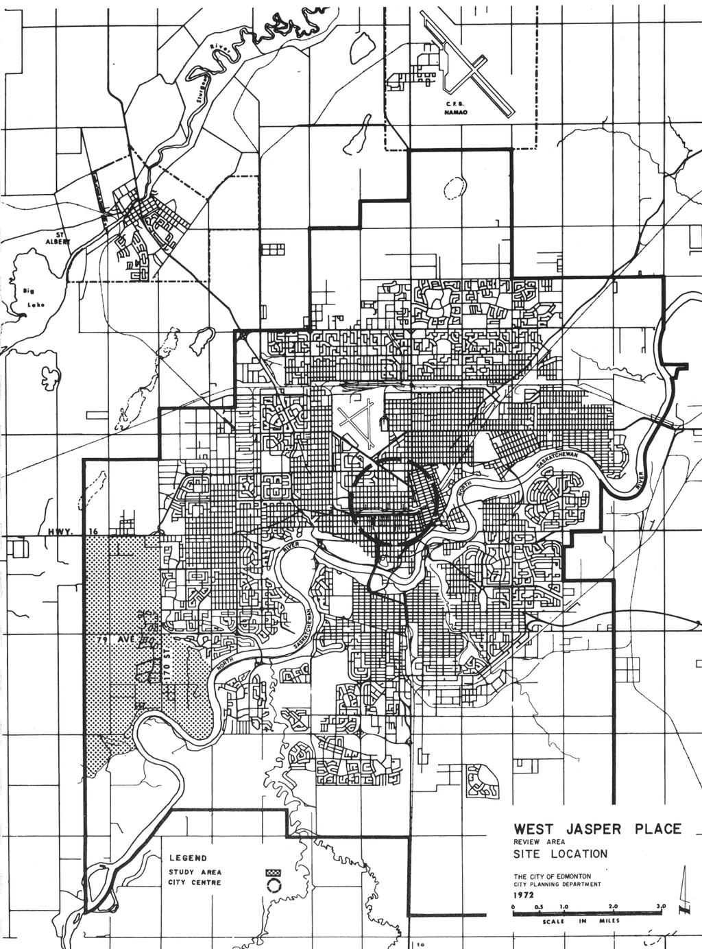
11
12
13
14
15
16

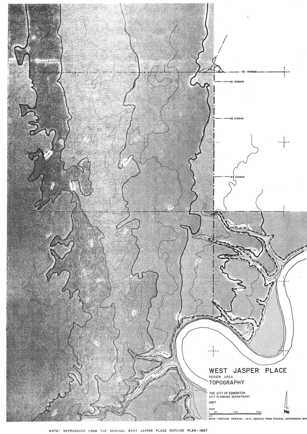
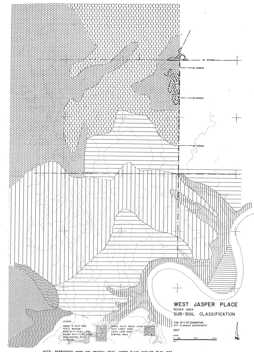
17 The site demands a sensitive handling of the handsome tree cover. Housing, roads, and footpaths should be carefully integrated into and among the existing vegetation. West Jasper Place has the best existing stands of mature trees in Edmonton and the opportunity to use them imaginatively must not be wasted. In certain cases, special detail design studies should be carried out prior to subdivision planning. Pedestrian movement should be safe and direct, particularly for the home elementary school journey. If the subdivisions are laneless, a system of walkways can be provided out of the 30 percent circulation reserve. These walkways should be related to the natural features of the site, such as lines of trees, ravines, and topography.
18 3. THE PLAN GENERAL STRUCTURE i. General The Scheme Area lies South of Stony Plain Road, West of 170 Street, East of the Outer Ring Road (Anthony Henday Drive) and North of the river and Wedgewood Ravine. It includes the area South of 79 Avenue (Whitemud Drive) and East of 170 Street. As indicated on the attached Revised Schematic General Structure Plan, the Scheme Area has been divided into a number of neighborhoods. Each neighborhood will provide housing accommodation for approximately 5,000 people, and is to have, as its focal point, a combined school and park area. It is estimated that the Scheme Area could provide accommodation for a population of approximately 76,800. Looked at in isolation, this would appear to be a major population agglomeration - one which could even perhaps be thought of as constituting a self-contained urban "unit" of its own. Nevertheless, because of the shape and location of the Scheme Area, urban development here would have to be very closely linked to that which presently exists in the Jasper Place vicinity. Major commercial centres serving the Scheme Area, would be Meadowlark Park to the East and the Centennial Village to the North-East. These facilities, coupled with the excellent roadway system proposed by the Metropolitan Edmonton Transportation Study, would inevitably have the effect of directing vehicular circulation from within the Scheme Area to key features outside. In other words, key facilities outside the Scheme Area, such as the two major shopping centres and the City Centre itself, would become very accessible. On the other hand, however, because of the existing shortage to the East of 170 Street (Jasper Place), of public facilities, such as parks and schools, it became obvious at a very early stage, to the designers of the Scheme, that the Scheme Area would have to be entirely self-contained in terms of schools, parks and other local facilities. Hence, within the Scheme Area there exist two conflicting circulation "desire-line " patterns. This is illustrated in design factor '1 '. The vehicular "desire-lines" flow outward from the Scheme Area, eastward to the rest of the City. The pedestrian "desire-lines" flow inward, within the Scheme towards the schools and parks.
19
20 It was the requirements of the circulation system, coupled with the excellent physical features of the site that resulted in the present Scheme structure. ii. Trees and Landscape Features The area West of 170 Street has some of the best tree cover of any land within or surrounding the City at present. It is therefore a major design criterion that a scheme for this area should be very sensitively related to the existing landscape features. Hence a major tenet in developing a design concept for this area was to very carefully integrate urban development with the fine landscape features that already exist there. A great deal of effort must be expended to ensure that the existing ravines, creeks, ponds and tree-lines will bear some relationship to the proposed vehicular routes and pedestrian areas in order to make the routes themselves more attractive, and to give quality and a sense of identity to the development as a whole. In addition to sensitively integrating circulation routes with the physical features existing on the site, it is considered highly desirable that certain site features of particular quality should be preserved more or less in their entirety. In order to achieve this, and at the same time obtain reasonable residential densities, it is recommended that care-fully sited buildings be located in and around these areas to create a minimum disturbance to each treed area. In the view of the Planning and Development Department, families can comfortably live in medium density accommodation, when this type of housing is counter-balanced by generous public open space immediately adjacent to it. In this case, the open space is provided by the combined school and park sites. Generally speaking, as distance from the school and park site increases, the density of the residential areas decreases until areas of predominantly single family dwellings are reached. Where self-contained kindergartens are required it is suggested that these be integrated directly into the local housing-groups, where they would be most accessible to small children. However a location adjacent to the community league may be considered. South of Whitemud Drive and West of the 170 Street Major Arterial, are located: (a) the school "campus" comprised of a major sports centre, public elementary school, public and separate junior high schools and public and separate senior high schools; (b) a large commercial centre opposite the school campus. These facilities have been located South of Whitemud Drive for a very good reason. North of Whitemud Drive and East of 170 Street, there already exist, at present, two major shopping centres, namely Meadowlark Park and Centennial Village, plus the Jasper Place Sports Centre. It therefore was felt that the Scheme Area South of Whitemud Drive would have to be more self-contained than the area to the North because of the relative inaccessibility of the facilities located East of
21 170 Street. In view of this fact, the sports and high school campus, and large shopping centre to the South of Whitemud Drive are in the most advantageous location to be most accessible to the maximum number of people, whether travelling by private vehicle, by public transport, or by foot. The residential areas surrounding these major facilities should be of higher density than those surrounding the school and commercial sites in the other neighborhoods of the Scheme Area. Residential areas zoned predominantly R2A, R3 and R3A would be quite acceptable surrounding the school campus and large shopping centre. Not only would this give very good accessibility to the school campus and large shopping centre for the maximum number of people, but the volume of building there, could create a visual focus or landmark identifying this centre as being the heart of the whole West Jasper Place Scheme. iii. Land-Use The overall land-use structure of the Scheme is a very simple one. Basically, the whole of the area has been divided into neighborhoods, each neighborhood accommodating approximately 5,000 people. A combined park and school is located roughly in the geographical centre of the catchment area of each neighborhood or group of neighborhoods (i.e. separate school system). Except where other conveniently located shopping facilities exist nearby, there is a small commercial complex adjacent to each school site. In other words, around the school site, a "node " has been created in which are located all the facilities which can be normally expected to serve the immediate residential population of about 5,000 people. In all cases the commercial centres have been located on the home-coming side of the street so as to avoid the congestion caused by a large number of vehicles waiting in the street to turn left into a shopping centre. The focus, then, of each residential neighborhood of about 5,000 people is the park and elementary school site (and in certain cases a junior high school and separate school as well), often coupled with a fairly small commercial development. Reaction from development and commercial companies and studies under-taken in other outline plan areas (Mill Woods Commercial Distribution Study) has pointed to the lack of an intermediate level of shopping facilities in the Outline Plan area. The original plan proposed only a single regional facility supplemented by small, two to five acre neighborhood centres. The ten to fifteen acre district facility had not been provided for, and it is accordingly proposed that consideration should be given to such outlets at appropriate locations, for example, at arterial or arterial-collector junctions. The Mill Woods study indicated that one such outlet per community of three to four neighborhoods or approximately 15,000 to 20,000 people, would be appropriate. Possible locations are not indicated on the revised Schematic General Structure Map 1972 since detailed locations should be determined at the detail design stage where it can be shown that the facility is necessary and desirable and will not adversely affect the intent of the Outline Plan.
22 iv. Vehicular Circulation No major changes have been found necessary to the overall arterial system at this time apart from refinements in the southern portion of the plan west of 170 Street where "T" junctions of lateral arterials with the north-south spine arterial road have been abandoned in favour of cross intersections. A proposed connection with the future Anthony Henday Drive in the vicinity of Wedgewood Ravine has been abandoned in favour of an interchange at the south-west corner of Neighborhood 10 in order to give more direct access to the arterial road system in the area and to avoid environmental damage to the ravine system. However, as indicated below, functional planning studies will have to be undertaken before precise alignments can be determined. Examinations of Anthony Henday Drive alignment and its interchange with Stony Plain Road have been carried out in conjunction with Alberta Infrastructure and Transportation and a more precise definition of right-of-way requirements has been evolved. This is also indicated in the Schematic General Structure Map but it should be noted that the right-of-way cannot yet be regarded as finalized and more functional planning studies must be undertaken. In the south-eastern portion of the plan, an examination is currently being undertaken of the southern extension of 170th Street and the future river crossing. The approved Outline Plan presently indicates a route down the ravine enclosed by the Edmonton Golf and Country Club. In the Scheme Area, the hierarchy of traffic movement is quite a simple one, but it does impose certain disciplines on the car driver. Within each "housing-group" there are Local Residential Streets onto which houses actually front. These streets are intended for slow moving local traffic, which actually terminates on the particular street. The housing-groups have been designed such that through traffic will be entirely eliminated. On the local streets we accept that there will be an admixture of pedestrian and vehicular movement, but as the amount of vehicular traffic generated by the housing-groups will be of a minimum nature, we anticipate no severe conflict between the needs of pedestrians and vehicles. Connecting all the housing-groups together there is a system of neighborhood collector roads, and it is these which also carry the buses serving the Scheme Area as a whole. The neighborhood collector roads should be aligned so as to sensitively knit into the contours of the site, and carefully relate to existing landscape features. The neighborhood collector roads join arterials which link at four points to the 170 Street Major Arterial. The Major Arterial then connects, by means of grade-separated interchanges, to Stony Plain Road and Whitemud Drive. These two freeways in turn link to Anthony Henday Drive. According to the best principles of roadway design, there must be no short-circuiting of this discipline. The hierarchy of travel is to be Local Residential Street Neighborhood Collector Road - Arterial - Major Arterial Road - Freeway; in every
23 case that discipline is intentionally imposed. It should be impossible, for example, to travel directly from a neighborhood collector road to a freeway. The opportunity of negotiating this type of maneuver has been intentionally excluded from the Scheme, as the rapid changes in speed involved are not only considered unsafe, but also serve to decrease the capacity of the Freeway Road. The only way to approach a Freeway is in fact, either via another Freeway or from a Major Arterial. This road hierarchy was developed in close cooperation with the Roadways Design Section of the Engineering Department and it has been mutually agreed that this is as close to an optimum road system as can be achieved within the Scheme Area. It is reiterated that the alignment of Stony Plain Road, South of Highway 16 is still under study and the alignment therefore, as shown on the General Structure Map, is subject to revision. As has already been noted, it is anticipated that it will be many years indeed before the City will expand West of Anthony Henday Drive. There is no doubt, however, that a freeway such as the Anthony Henday Drive could provide a very significant "fence" around the City, one which could discourage further westerly expansion. This is a very deisrable element as it tends to function as a "containing" device, preventing further unchecked suburban sprawl, which is wasteful and uneconomical, and allowing the City to strongly build up within the Anthony Henday Drive barrier. It is realized however, that it may be ultimately desirable to expand Edmonton beyond the Anthony Henday Drive, although this would likely be a great many years in the future. To accommodate expansion West of the Anthony Henday Drive, westerly road extensions are advocated via Stony Plain Road, Whitemud Drive and an arterial bridge and intersection South of Whitemud Drive. It must be reiterated, however, that development West of the Outer Ring Road should be discouraged for a very long time to come. v. Bus Routes An adjustment to the pattern of bus routes originally proposed has been found necessary. The new routes are shown in the plan entitled "West Jasper Place Public Transportation Routes".
24
25 vi. Pedestrian Circulation One of the special features of the Scheme Area is a purpose-designed public pedestrian circulation network, which will link all the housing groups to the elementary schools, junior high schools, and the senior high schools. It must be remembered that, even in our highly motorized society, there is a fairly large sector of the population who do not, or can not, drive their own cars. This would include, for example, school and preschool children below driving age, elderly people (of which there is an ever increasing number) and others, such as wives, who cannot drive when the husband has taken the family car to his place of business. This pedestrian system will provide very direct access for people on foot to bus shops and key facilities within the Scheme Area, it will provide safely accessible Open Space very close to each dwelling, and it will give a real parkland setting to the Scheme as a whole. The pedestrian system is one of the major features of the Scheme, and it is important that it be adopted in total. If the pedestrian system is compromised upon, the Scheme as a whole will undoubtedly lose a great deal of its quality. (For details of walkway design see the report "Walkways in Residential Areas" prepared by the Planning and Development Department) vii. The South-East A problem area is that immediately abutting the Edmonton Golf and Country Club to the south-east. Because of the fine mature trees there, the existence of the golf course, the roadway and bridge proposals for 170th Street as it approaches Terwillegar Heights Park south of the river, and the fragmented ownership, this area must be the subject of a special design study prior to detailed proposals being made. viii. Public Housing In the development of new residential areas, there exists the opportunity of earmarking certain sites for public housing. This must be done primarily because of the need for this type of accommodation but also as one of the first steps in dealing with our more central renewal and rehabilitation areas. Before any clearance of substandard residential accommodation can be contemplated in the older areas, alternative housing will have to be found for people presently occupying these sites. While some of these families will require to be re-housed very near these areas, it is contended that a large proportion could happily and economically be provided for in the newer areas such as West Jasper Place. Sites for public housing must be identified prior to obtaining detailed subdivision approval and the method of acquisition established in developers' agreements with the City.
26 ix. Special Uses (e.g.) auxiliary hospital, nursing home, old persons home. Steps are now being taken with those agencies concerned to determine needs and appropriate locations for special uses such as nursing homes. If this Outline Plan is adopted and future demands for these facilities are made evident, they can be satisfied by the later substitution of the uses in question for whole or parts of suitably located housing-groups.
27 4. LAND AVAILABLE FOR DEVELOPMENT Population Density and Distribution History: On March 24th, 1969, the West Jasper Place Outline Plan was approved in principle by City Council. The plan proposed a total population of approximately 67,500 persons for a developable area of 3,500 acres or approximately 19 persons per gross acre. The plan did not include an in-depth analysis of population distribution on a neighborhood basis, but gave general guide lines for the location of high densities in relation to neighborhood centre, schools and park and major educational recreational and commercial centres. Applications for approval of subdivision in the area have since been reviewed in relation to the Outline Plan and approvals have established densities in five neighborhoods. However, considerable difficulty was experienced in keeping densities to an acceptable range and it became evident that a more sophisticated vehicle than the original Outline Plan should be developed against which to assess future applications. In developing the Density Distribution Plan, the Planning and Development Department reviewed development patterns emerging elsewhere in the City and the capacity of the Outline Plan area in terms of the population that could be accommodated by the circulation systems, the school and park distribution plan and the utility networks. The result of this review indicated that the area could accommodate a total ceiling population of approximately 76,800 persons or 23.4 persons per gross acre (57.8 persons per gross hectare). The Density Distribution Plan indicates ceiling densities on a neighborhood basis (see appendix) together with a recommended percentage area breakdown for the different zoning categories for the balance of the plan area.
28 R-1 R-2 R-2A R-3 73% 2% 16% 9% It is possible that market requirements may cause this breakdown to be changed, but the total population should not be exceeded and the school distribution pattern must be respected. The populations allocated on a neighborhood basis have been established in relation to location and topography of the neighborhoods, ground conditions, accessibility and school distribution pattern. The total developable area North of the Whitemud Drive right-of-way and West of the 170 Street Major Arterial right-of-way is approximately 1,334 acres (540 hectares). At an over-all average density of 23.7 persons per acre (58.5 ppha), this area could accommodate approximately 31,630 people. South of the Whitemud Drive right-of-way and West of the 170 Street Major Arterial right-of-way, the developable area (excluding Wedgewood Estate) is approximately 1,473 acres (596 hectares). At an over-all average density of 24 persons per acre (58.5 ppha)), this area could accommodate approximately 35,474 people. It is felt that the area lying South of the Whitemud Drive right-of-way and East of the right-of-way for the 170 Street Major Arterial Road, will be intimately tied to any development occurring West of 170 Street. Excluding Patricia Heights and major Edmonton Country Club holdings, the developable area East of 170 Street is estimated at roughly 472 acres (191 hectares). This is extremely approximate as there are a number of unknowns related to the long term future plans of the Edmonton Golf and Country Club, and the 170 Street bridge. Taking the 472-acre (191 hectares) figure at an average density of 20.5 persons per acre (50.6 ppha), the area could accommodate approximately 9,700 people. Adding the Patricia Heights population of about 1,500, the population involved, East of 170 Street, would be roughly 11,200. The total area then, which could be developed in West Jasper Place, is approximately 3,279 acres (1327 hectares), excluding Patricia Heights. This area could accommodate a population in the order of 76,800 or 78,300 if Patricia Heights is included. Summary of population for West Jasper Place as per district () Area Gross Population Density Northern District 1334 acres (540 hectares) 31, p./g.a. (58.8 p/ha) Southern District 1473 acres (596 hectares) 35, p./g.a. (59.3 p/ha) Eastern District 472 acres (191 hectares) 9, p./g.a. (50.6 p/ha) 3279 acres (1327 hectares) 76, p./g.a. (57.8 p/ha)
29 POPULATION DENSITY AND DISTRIBUTION * as per neighborhood SUMMARY Neighborhood Gross arces/hectares Population Density / 88 4, ppga/ppgha / 77 5, / / 105 6, / / 96 5, / / 96 5, / / 79 4, / / 77 3, / / 77 8, / / 89 4, / / 86 4, / / 94 4, / a 242 / 98 4, / / 77 4, / / 191 9, / ,279 / , ppga / 57.8ppgha * More detailed calculations may be obtained on application from Urban Design Branch. Planning Department.
30 PLANNING REQUIREMENTS It has been calculated that for a West Jasper Place population of approximately 76,800, there will be a need for the following facilities: Churches Active treatment hospital Auxiliary hospital Nursing homes Gas stations Local commercial centres Intermediate commercial centre (site up to 15 acres / 6.0 hectares) District commercial centre (approx.) 21 1* 1* 2* (approx.) 1 In addition to retail shops, and perhaps some office accommodation, the District Centre should also include: 1 Branch Library 1 Regional Health Clinic * 1 Satellite Police Station 1 Fire Station Schools Public Separate Elementary 15 8 Junior High 5 3 Senior High 1 1 Public Elementary 1 Public Junior High 1 Public High 1 Separate Junior High 1 Separate High 1 District Sports Centre and Recreational Area Parks: Due to the existing shortage of open space in Jasper Place, any development occurring West of 170 Street is to be entirely self-sufficient in terms of local park land. These parks are provided in combination with school sites, as has been the practice elsewhere in Edmonton. * Subject to further study.
31 Public Land and Facility Requirements General Recent resolutions of City Council and experience gained in other Outline Plan areas has focused attention on the need to identify, prior to approval of the Outline Plan, the following additional uses not specifically covered by that Plan: 1. Public Housing "that 5 per cent of the population of future sub divisions be made available for public housing in new areas". 2. Mobile Homes "The City express its willingness to favourably consider proposals for mobile home parks and/or subdivision which are located within Outline Plan areas and which are designed for integration into the comprehensive development of these areas; and that the Municipal Planning Commission be directed to consider the provision of mobile home sites in its consideration of Outline Plans ". 3. Nursing Homes and Senior Citizens Homes Although no specific sites are indicated in the Outline Plan, senior citizens and nursing homes can and should be considered for integration into any of the neighborhoods yet to be planned in the Outline Plan area. The precise number of facilities must be determined by demand but the following criteria should be used in determining preferred locations: a. that there has to be action and activity; b. walking distance to the neighborhood facilities and also to the public transportation systems must be minimized; c. a location adjacent to the public open space system allowing walks to be made without the necessity of crossing a heavily trafficked street.
32 6. DEVELOPERS' AGREEMENTS In order to ensure that the continuing development of the West Jasper Place area is undertaken with minimal costs to the taxpayer, and that land required for schools, parks, roads and other public purposes may be obtained either at no charge or at reasonable cost, it is proposed that no further developments be permitted in the Outline Plan area prior to developers' agreements being entered into with the City by all affected developers. Under the Preliminary Regional Plan, Metropolitan Part, Part II, Section 4, the City has the power to prevent subdivision and development where conditions for the economical development of the area are not met. Preliminary Regional Plan, Metropolitan Part, Part II, Section 4 a) General Purposes To provide economically serviceable land for the general urban needs of Metropolitan Edmonton. The General Urban Zone is intended to provide sufficient land for a minimum period of five years at the prevailing rate of population growth. b) Permitted Uses Such development as may be permitted in accordance with the provisions of Section 99 (d) of The Town and Rural Planning Act as now amended, which provisions include housing, service industry, retail and wholesale business, public or quasi-public uses, institutions and other uses which may properly be included in a general urban area; provided that such subdivision and development will only be permitted in accordance with the detailed zoning requirements or policy of the municipality. And further, it will only be permitted when the plan and development of the land is made possible by the solution of such of the following problems as may exist: Currently approved subdivision plans have related to this revised figure. However, the Parkland Services Branch of the Asset Management and Public Works Department has indicated that they have no objections to increasing the density ceiling in the Outline Plan provided that the new school and park site standards established by the new Parks Master Plan are followed. These standards, when incorporated with the revised joint planning committee site standards developed after approval of the Parks Master Plan, increased the school/park requirements to in the region of 410 to 420 acres ( hectares) or approximately 12½% of latest estimate of developable area - 3,279 acres (1327 hectares) (an accurate estimate of develop-able area cannot yet be obtained due to fluctuating Outer Ring Freeway alignments and the absence of a detailed survey of the top-of-the-bank line at ravines and river valley). However, it is estimated that with economical circulation design, total public land requirements - schools, parks and circulation - could be accommodated by 40% of the gross developable area. For reference purposes, the
33 estimated developable area and public land requirements are tabulated below: (M.P.C. Minutes of Dec. 9/71 meeting). Original Gross Developable Area (Excludes freeways and ravine lands) Original public land requirements (schools and parks only) = 10% = Maximum available for circulation = 30% = Total = 40% = Revised Gross Developable Area 3,500 acs / 1416 hectares 350 acres / 142 hectares 1,050 acres / 425 hectares 1,400 acres / 567 hectares 3,279 acs / 1327 hectares Revised public land requirements = 12.8% = 420 acres / 170 hectares Recommended maximum available for circulation = 27.2% = 892 acres / 361 hectares Total = 40.0% = 1,302 acres / 527 hectares The original proposal showed the two schools in the centre of adjacent neighborhoods astride the east-west access of the six neighborhood groups. (See original Outline Plan - School Catchment Areas map following page 56). This arrangement meant that the sites could not be obtained until the late stages of the plan and gave rise to elongated catchment areas which could only be properly served by bus. The improved solution was to move the western-most site southwards to Neighborhood 5 (Alder-grove) and the eastern-most site northward to Neighborhood 2. The revised locations are indicated on the Revised Schematic General Structure Map 1972, included in this report. The next revision was the relocation of the separate elementary school originally indicated in the major campus Neighborhood 7 (Callingwood), west to Neighborhood 9 (Willowdale). The main purpose of this move was to facilitate planning in the major campus where problems have been encountered due to the number and type of schools and the large land area requirements. The original approved Outline Plan indicates that the total school and park requirements could be met by a 10% reserve dedication, being 350 acres (142 hectares) of the gross developable area of 3,500 acres (1416 hectares). Shortly after approval of the plan, however, revised school and park requirements increased the total acreage needed from 350 to acres (142 to 149 hectares). At the same time a more precise calculation of developable area indicated a reduction from 3,500 to 3,357 acres (1416 to 1327 hectares), resulting in a total shortage of approximately 33 acres (13 hectares). 4. Active Treatment and Auxiliary Hospitals At the present time (March, 1972) it has not been determined whether sites for active treatment or auxiliary hospitals are required in the West Jasper Place area. However, according to the average ratio of such facilities to population it is possible that one
34 active treatment hospital and one auxiliary hospital may be required in the Outline Plan area (see following table). If this were confirmed, approximately 21 acres (8.5 hectares) would be needed. This has been taken into account in the calculations of public land requirements and the make-up of Neighborhood 11A which could most easily accommodate the facilities at this stage in the plan. 5. School Distribution i. General The Schools have been carefully sited so as to coincide with, and therefore offer the maximum protection to, the major areas of existing landscape quality. The catchment area for each public elementary school is the " quadrant" within which the school lies. A few quadrants together form the catchment area for a Public Junior High School and a Separate Elementary School. These quadrants have been arranged in such a way that both the walkway and bus systems give direct access to each of the schools with a minimum of inconvenience. In no case does a student live farther than 1½ miles (2.4 kilometres) from a separate elementary school or junior high school (1½ miles (2.4 kilometres) is the maximum distance recommended by the Public School Board), and in the case of the local public elementary school, he lives very much closer than that. There is one major high school "campus " proposed, South of the Whitemud Drive, and this will become the high school focus for the whole of the Scheme Area. The number and type of schools has not been changed from the original plan but an improvement on the distribution of two public junior high schools in the northern portion of the plan was developed which will facilitate the staging of those facilities.
35
36
37 i. provisions, on an economic basis, of all necessary utilities, other urban services, and the location and provision of major roads; ii. drainage of low or boggy land; iii. replotting of an area, large enough to initiate development on a neighborhood basis; iv. conclusion of agreement with developers concerning the financing of essential public works. " It is further recommended that Council not permit the establishment of detailed zoning for subdivision plans affected unless development agreements have been entered into by the parties concerned.
Central and East Neighbourhoods - Hermitage Outline Plan
 Central and East Neighbourhoods - Hermitage Outline Plan Office Consolidation September 2013 Prepared by: Planning and Policy Services Branch Planning and Development Department City of Edmonton The Central
9 CITY OF VAUGHAN OFFICIAL PLAN AMENDMENT NO BOCA EAST INVESTMENTS LIMITED
 9 CITY OF VAUGHAN OFFICIAL PLAN AMENDMENT NO. 631 - BOCA EAST INVESTMENTS LIMITED The Planning and Economic Development Committee recommends the adoption of the recommendations contained in the following
Kaskitayo Outline Plan
 Kaskitayo Outline Plan Office Consolidation June 2017 Prepared by: City Planning Branch Sustainable Development City of Edmonton The Kaskitayo Outline Plan was approved by resolution by Council in October
S o u t h C e n t r a l O u t l i n e P l a n. Leduc Business Park. North Leduc Industrial Area Structure Plan C it y of Led u c.
 Leduc Business Park North Leduc Industrial Area Structure Plan C it y of Led u c Prepared for Farm Air Properties Inc. January, 2007 Table of Contents Page Number 1.0 Purpose of Plan and Definition of
6. REGIONAL AND COMMUNITY FACILITIES DESIGNATIONS 6.1. OBJECTIVES FOR REGIONAL AND COMMUNITY FACILITIES LAND USE DESIGNATIONS
 6. REGIONAL AND COMMUNITY FACILITIES DESIGNATIONS INTRODUCTION The Regional and land use designations provide the primary locations for uses which satisfy the health, education and other service needs
Mayliewan Neighbourhood Structure Plan Neighbourhood 7 of the Edmonton North Area Structure Plan
 Mayliewan Neighbourhood Structure Plan Neighbourhood 7 of the Edmonton North Area Structure Plan Office Consolidation November 2008 Prepared by: Planning and Policy Services Branch Planning and Development
Terra Losa Neighbourhood Structure Plan
 Terra Losa Neighbourhood Structure Plan Office Consolidation May 2006 Prepared by: Planning and Policy Services Branch Planning and Development Department City of Edmonton Bylaw 6616 was adopted by Council
Terra Losa Neighbourhood Structure Plan
 Terra Losa Neighbourhood Structure Plan Office Consolidation January 22, 2018 Prepared by: City Planning Urban Form and Corporate Strategic Development City of Edmonton Bylaw 6616 was adopted by Council
North Oakville East Parks Facilities Distribution Plan. November, 2009
 North Oakville East November, 2009 POLICY CONTEXT 1) Purpose a) The purpose of this document is to be a guide for the location, configuration, design and development of the parks system for the North Oakville
Canossa NSP. Office Consolidation August Prepared by: Planning and Policy Services Branch Planning and Development Department City of Edmonton
 Canossa NSP Office Consolidation August 2004 Prepared by: Planning and Policy Services Branch Planning and Development Department City of Edmonton Bylaw 7613 (as amended) was adopted by Council October
I. INTRODUCTION. Project Background and Study Area
 I. INTRODUCTION Project Background and Study Area Freedom Parkway is a key east-west corridor connecting I-25 on the west to the Town of Kersey on the east, running approximately one to two miles south
TO: Mayor & Council DATE: April 12, The Planning and Development Department and the Engineering Department recommend that Council:
 CORPORATE REPORT NO: R080 COUNCIL DATE: April 12, 2010 REGULAR COUNCIL TO: Mayor & Council DATE: April 12, 2010 FROM: SUBJECT: General Manager, Planning and Development General Manager, Engineering Neighbourhood
City of Heath. Town Center Concept
 In the give-and-take of getting projects designed, financed, and approved, the famous refrain from the film Field of Dreams is heard often: if you build it, they will come. From the perspective of the
OP Council Resolution June 16, Planning and Development Services
 OP-08-01 Council Resolution June 16, 2008 Planning and Development Services Kingsgate Landing Outline Plan Table of Contents 1.0 Introduction 1 1.1 Purpose of Plan 1 1.2 Plan Area Location 1 1.3 Ownership
AWH REPORT OF THE PLANNING AND DEVELOPMENT DEPARTMENT FOR APPLICATION FOR REZONING ORDINANCE TO PLANNED UNIT DEVELOPMENT
 AWH REPORT OF THE PLANNING AND DEVELOPMENT DEPARTMENT FOR APPLICATION FOR REZONING ORDINANCE TO PLANNED UNIT DEVELOPMENT MAY 8, 2014 The Planning and Development Department hereby forwards to the Planning
COLVER ROAD INDUSTRIAL CONCEPT PLAN
 COLVER ROAD INDUSTRIAL CONCEPT PLAN A CONCEPTUAL LAND USE AND TRANSPORTATION PLAN FOR TA-4 AN URBAN RESERVE AREA OF THE CITY TALENT City of Talent Adopted by City Council Resolution No., June, 2015 PART
6 Growth Management Challenges and Opportunities
 6 Growth Management Challenges and Opportunities The Town has established a goal of attaining a 50% participation rate with respect to employment opportunities versus residential population. The Town s
City of Grande Prairie Development Services Department
 City of Grande Prairie Development Services Department ROYAL OAKS NORTH OUTLINE PLAN OP-07-03 NW 35-71-6 W6M May 7, 2007 Royal Oaks North Outline Plan TABLE OF CONTENTS 1.0 INTRODUCTION........ 3 1.1 Purpose
Mill Woods Town Centre Proposed Rezoning LDA
 Mill Woods Town Centre Proposed Rezoning LDA15 0649 The City of Edmonton has received an application for rezoning and an amendment to the Mill Woods Station Area Redevelopment Plan (ARP) for the Mill Woods
3.10 LAND USE SETTING PROJECT SITE EXISTING LAND USE DESIGNATIONS AND ZONING. General Plan Land Use Designations.
 This section of the Draft EIR addresses the existing land uses on and adjacent to the project site and discusses the potential impacts of the proposed project on existing land uses. Key issues addressed
ARTICLE 6: Special and Planned Development Districts
 ARTICLE 6: Special and Planned Development Districts 6-10 Traditional Neighborhood Development (TND) District 6-10.10 Purpose and Intent The Traditional Neighborhood Development (TND) District provides
Asbury Chapel Subdivision Sketch Plan
 Asbury Chapel Subdivision Sketch Plan PART 1: PROJECT SUMMARY Applicant: NVR Inc. Project Size: +/- 76.13 acres Parcel Numbers: 02101112,02116101,02116112, 02116113 Current Zoning: Transitional Residential
STAFF REPORT. December 20, North York Community Council. Director, Community Planning, North York District
 STAFF REPORT December 20, 2005 To: From: Subject: North York Community Council Director, Community Planning, North York District Preliminary Report Application to Amend the Official Plan and Zoning By-law
13 THORNHILL YONGE STREET STUDY IMPLEMENTATION CITY OF VAUGHAN OPA 669 AND TOWN OF MARKHAM OPA 154
 13 THORNHILL YONGE STREET STUDY IMPLEMENTATION CITY OF VAUGHAN OPA 669 AND TOWN OF MARKHAM OPA 154 The Planning and Economic Development Committee recommends the adoption of the recommendations contained
THAT the attached Terms of Reference for the Thornhill Centre Street Study be approved.
 COMMITTEE OF THE WHOLE AUGUST 18, 2003 THORNHILL CENTRE STREET STUDY PLANNING FILE: 15.92 Recommendation The Commissioner of Planning recommends: THAT the attached Terms of Reference for the Thornhill
THE CORPORATION OF THE TOWN OF OAKVILLE BY-LAW NUMBER
 THE CORPORATION OF THE TOWN OF OAKVILLE BY-LAW NUMBER 20012-08530 A by-law to adopt an amendment to the Official Plan of the Oakville Planning Area (Official Plan Amendment 198) Land North of Dundas Street.
GEORGE DERBY COMMUNITY PLAN
 Planning and Building Department GEORGE DERBY COMMUNITY PLAN The following Council Report constitutes the George Derby Community Plan as adopted by Council in 1989. TO: MUNICIPAL MANAGER 1989 OCTOBER 17
ESTABLISH AN EFFICIENT TOWN CENTER
 ESTABLISH AN EFFICIENT TOWN CENTER 4 Overview Lisbon residents are proud of the history of Newent and at the same time recognize its current importance as a centralized location for a variety of municipal
ROAD CLOSURE AND LAND USE AMENDMENT SILVER SPRINGS (WARD 1) NORTHEAST OF NOSEHILL DRIVE NW AND SILVER SPRINGS ROAD NW BYLAWS 2C2018 AND 29D2018
 NORTHEAST OF NOSEHILL DRIVE NW AND SILVER SPRINGS ROAD NW BYLAWS 2C2018 AND 29D2018") Page 1 of 19 EXECUTIVE SUMMARY This application proposes redesignating two parcels in the community of Silver Springs from Special Purpose Future Urban Development (S-FUD) District and undesignated road
Page 1 of 19 EXECUTIVE SUMMARY This application proposes redesignating two parcels in the community of Silver Springs from Special Purpose Future Urban Development (S-FUD) District and undesignated road
EXECUTIVE SUMMARY. Introduction
 Introduction EXECUTIVE SUMMARY The Urban Service Area Fort McMurray (hereafter referred to as the Urban Service Area) is currently experiencing a variety of development pressures. Unprecedented population
Local Growth Planning in North Central Green Line Communities
 2018 April 30 Page 1 of 6 EXECUTIVE SUMMARY This report outlines a high-level scope for local growth planning for north central Green Line communities. The catalyst for this review is the significant investments
Section 9 NEIGHBORHOOD DESIGN
 Section 9 NEIGHBORHOOD DESIGN City of Lancaster Comprehensive Plan D u n k i n, S e f k o & A s s o c i a t e s, I n c. NEIGHBORHOOD DESIGN INTRODUCTION There are many ways in which a neighborhood can
OFFICE CONSOLIDATION SECONDARY PLAN AREA 22 THE BRAMALEA SOUTH INDUSTRIAL SECONDARY PLAN
 OFFICE CONSOLIDATION SECONDARY PLAN AREA 22 THE BRAMALEA SOUTH INDUSTRIAL SECONDARY PLAN November 2010 EXPLANATORY NOTES (Secondary Plan Area 22) General (pertaining to all secondary plan office consolidations)
Land Use Amendment in Southwood (Ward 11) at and Elbow Drive SW, LOC
 at and Elbow Drive SW, LOC") 2018 November 15 Page 1 of 10 EXECUTIVE SUMMARY This land use amendment application was submitted by Rick Balbi Architect on 2017 August 31 on behalf of Sable Developments Ltd, and with authorization from
2018 November 15 Page 1 of 10 EXECUTIVE SUMMARY This land use amendment application was submitted by Rick Balbi Architect on 2017 August 31 on behalf of Sable Developments Ltd, and with authorization from
CHAPTER 7: VISION AND ACTION STATEMENTS. Noble 2025 Vision Statement
 CHAPTER 7: VISION AND ACTION STATEMENTS This chapter presents the vision, policy and action statements that transform the comprehensive planning study, an analysis of Noble s past, future trends and community
KEIZER STATION PLAN INTRODUCTION
 KEIZER STATION PLAN INTRODUCTION Planning for this area began in 1987 when the Keizer Comprehensive Plan established the Chemawa Activity Center and McNary Activity Center. The first Chemawa Activity Center
Planning and Public Consultation Process for the Preparation of a General Land Use Plan for South Port Kells TERMS OF REFERENCE
 APPENDIX "B" Planning and Public Consultation Process for the Preparation of a General Land Use Plan for South Port Kells TERMS OF REFERENCE PURPOSE South Port Kells is located in the northeastern quadrant
Chapter 1 - General Design Guidelines CHAPTER 1 GENERAL DESIGN GUIDELINES
 CHAPTER 1 GENERAL DESIGN GUIDELINES 1.0 INTRODUCTION This Publication has been developed to provide current, uniform procedures and guidelines for the application and design of safe, convenient, efficient
6 RURAL RESIDENTIAL. 6.1 Rural Use. Rural Use (RU) Goals and Objectives. Policy Goal
 Goals and Objectives. Policy Goal") 6 RURAL RESIDENTIAL The vast majority of East Hants 466,426 acres are considered rural in nature and are characterized by a great diversity of uses. Because of this, land use policies in rural areas of
6 RURAL RESIDENTIAL The vast majority of East Hants 466,426 acres are considered rural in nature and are characterized by a great diversity of uses. Because of this, land use policies in rural areas of
MAYFIELD WEST SECONDARY PLAN PHASE 2
 MAYFIELD WEST SECONDARY PLAN PHASE 2 Public Open House #3 February 25, 2010 Draft Preferred Land Use Scenario TOWN OF CALEDON PLANNING & DEVELOPMENT DEPARTMENT Open House Agenda TOWN OF CALEDON 1. Welcome
Outer Congress Street Land Use
 Outer Congress Street Land Use Outer Congress Street, with its historic residential district, natural resource and open space amenities, trail network, and proximity to major transportation infrastructure
Chappelle Neighbourhood Area Structure Plan
 Chappelle Neighbourhood Area Structure Plan Office Consolidation September 2017 Prepared by: City Planning Urban Form and Corporate Strategic Development City of Edmonton Bylaw 14779 was adopted by Council
CITY OF EDMONTON NORTHWEST INDUSTRIAL AREA OUTLINE PLAN
 CITY OF EDMONTON NORTHWEST INDUSTRIAL AREA OUTLINE PLAN North-West Industrial Area Outline Plan Office Consolidation North-West Industrial Area Outline Plan Office Consolidation March 2014 Prepared by:
AREASTRUCTURE PLAN AMENDMENT COCHRANE NORTH
 AREASTRUCTURE PLAN AMENDMENT COCHRANE NORTH In order to implement the vision outlined in the Conceptual Scheme, the following three amendments to the Cochrane North ASP are proposed: 1. Allow commercial
COUNTY COUNCIL OF PRINCE GEORGE'S COUNTY, MARYLAND SITTING AS THE DISTRICT COUNCIL 2010 Legislative Session. Council Members Dernoga and Olson
 DR- COUNTY COUNCIL OF PRINCE GEORGE'S COUNTY, MARYLAND SITTING AS THE DISTRICT COUNCIL 00 Legislative Session Bill No. CB--00 Chapter No. Proposed and Presented by Introduced by Co-Sponsors The Chairman
WEST HILL BUSINESS PARK AREA STRUCTURE PLAN
 MUNICIPAL DISTRICT OF PEACE NO. 135 WEST HILL BUSINESS PARK AREA STRUCTURE PLAN Prepared by: TABLE OF CONTENTS 1.0 Introduction... 1 1.1 Purpose of Plan........ 1 1.2 Plan Area..... 1 1.3 Existing Conditions...
City Of Sparks Planning Commission Item
 Page 1 of 12 City Of Sparks Planning Commission Item Meeting Date: May17, 2012 Subject: PCN12009, Public Hearing, Consideration and possible action on a Master Plan Amendment and Rezoning request to change
A General Summary of Land Use Zones 1
 A General Summary of Land Use s 1 2 A General Summary of Land Use s A General Summary of Land Use s Land use zones are used to classify and regulate land development and use. The following descriptions
HURON COMMUNITY PLAN
 CITY OF KITCHENER DEPARTMENT OF DEVELOPMENT AND TECHNICAL SERVICES PD 94/7 HURON COMMUNITY PLAN Recommended by Planning and Economic Development Committee: October 31, 1994 Adopted by Kitchener City Council:
Baumgarten MPUD. Exhibit 3 Evaluation Criteria
 Pursuant to LDC subsections 10.02.13 B, 10.02.08 F and Chapter 3 G. of the Administrative Code, staff s analysis and recommendation to the Planning Commission, and the Planning Commission s recommendation
Leduc Industrial Outline Plan SE W4
 Leduc Industrial Outline Plan SE 1-50-25-W4 Within the North Leduc Industrial ASP Prepared for: Leduc Energy Park Ltd. Prepared by: Stantec Consulting Ltd. File No. 1161 104655 V5 Table of Contents 1.0
and services The protection and conservation of environmentally significant and sensitive natural heritage features and functions.
 6. Land Use 6.0 Preamble A healthy and livable city is one in which people can enjoy a vibrant economy and a sustainable healthy environment in safe, caring and diverse neighbourhoods. In order to ensure
ADMINISTRATION RECOMMENDATION 2016 November 03. That Calgary Planning Commission recommends APPROVAL of the proposed Land Use Amendment.
 Page 1 of 12 EXECUTIVE SUMMARY This Land Use Amendment application covers an area of 75.76 hectares ± (187.20 acres ±) located in northeast Calgary, bound by Stoney Trail NE to the north, 128 Avenue NE
E. RURAL COMMERCIAL/INDUSTRIAL PARK MODEL
 E. RURAL COMMERCIAL/INDUSTRIAL PARK MODEL 1. PURPOSE The purpose of the Rural Commerce/Industrial Park Model is to provide parameters within which a grouping of business buildings with parking, loading
Gold Line Bus Rapid Transit Transit Oriented Development (BRTOD) Helmo Station Area Plan
 Helmo Station Area Plan") Appendix F Gold Line Bus Rapid Transit Transit Oriented Development (BRTOD) Helmo Station Area Plan Introduction and Purpose of the Plan The Gold Line Bus Rapid Transit facility is an eleven-mile dedicated
Appendix F Gold Line Bus Rapid Transit Transit Oriented Development (BRTOD) Helmo Station Area Plan Introduction and Purpose of the Plan The Gold Line Bus Rapid Transit facility is an eleven-mile dedicated
Ten Mile Creek Planning Area
 PLANNING AREA POLICIES TEN MILE CREEK Ten Mile Creek Planning Area Location and Context The Ten Mile Creek Planning Area ( Ten Mile Creek area ) is located south of the current Boise AOCI, generally south
COMMUNITY DESIGN. GOAL: Create livable and attractive communities. Intent
 COMMUNITY DESIGN Intent An attractive, well-designed County will attract quality development, instill civic pride, improve the visual character of the community, and create a strong, positive image for
4.11 Town Centre Secondary Plan (Former City of Cumberland)
") 4.11 Town Centre Secondary Plan (Former City of Cumberland) 4.11.1 Town Centre Objectives 4.11.1.1 Introduction The reason for the preparation of this Secondary Plan for the Town Centre is as follows:
4.11 Town Centre Secondary Plan (Former City of Cumberland) 4.11.1 Town Centre Objectives 4.11.1.1 Introduction The reason for the preparation of this Secondary Plan for the Town Centre is as follows:
Bylaw No. B-03/2011 Adopted by Airdrie City Council February 21, 2012
 COOPER S CROSSING STAGE 4 Neighbourhood Structure Plan City of Airdrie WESTMARK HOLDINGS LTD. Bylaw No. B-03/2011 Adopted by Airdrie City Council February 21, 2012 CONSULTANTS: LAND USE PLANNING: Southwell
Glenborough at Easton Land Use Master Plan
 Implementation 114 9.0 IMPLEMENTATION 9.1 OVERVIEW This chapter summarizes the administrative procedures necessary to implement the proposed land use plan, infrastructure improvements, development standards,
5 TOWN OF MARKHAM OFFICIAL PLAN AMENDMENT NO. 144 MILLIKEN MAIN STREET SECONDARY PLAN
 5 TOWN OF MARKHAM OFFICIAL PLAN AMENDMENT NO. 144 MILLIKEN MAIN STREET SECONDARY PLAN The Planning and Economic Development Committee recommends the following: 1. The communication from Brendan O Callaghan,
WHITELEY TOWN COUNCIL NORTH WHITELEY DEVELOPMENT SEPTEMBER 2014
 WHITELEY TOWN COUNCIL NORTH WHITELEY DEVELOPMENT SEPTEMBER 2014 Dear Resident This Special Edition of the Whiteley Voice which has been prepared in conjunction with the North Whiteley Consortium is to
LAND USE ELEMENT. Purpose. General Goals & Policies
 LAND USE ELEMENT Purpose This Land Use Element contains the goals and policies necessary to support the City s responsibility for managing land resources and guiding development through implementing regulations,
Draft TISCORNIA ESTATE SPECIFIC PLAN/EIR
 Draft TISCORNIA ESTATE SPECIFIC PLAN/EIR Submitted CONTENTS 1. PLAN SUMMARY II. INTRODUCTION IX. SPECIFIC PLAN RELATIONSHIPS X. XI. List of Figures 1. Regional Location 2. Point Richmond Area 3. Planning
KANATA CENTRUM 255 KANATA AVENUE OFFICIAL PLAN AMENDMENT ZONING BY-LAW AMENDMENT
 KANATA CENTRUM 255 KANATA AVENUE OFFICIAL PLAN AMENDMENT ZONING BY-LAW AMENDMENT JUNE 2015 PREPARED BY: FOTENN Consultants Inc. 223 Mcleod Street Ottawa, ON K2P OZ8 (613) 730-5709 PREPARED FOR: Kanata
POLICY AMENDMENT AND LAND USE AMENDMENT KILLARNEY/GLENGARRY (WARD 8) NW CORNER OF RICHMOND ROAD AND 33 STREET SW BYLAWS 1P2015 AND 7D2015
 NW CORNER OF RICHMOND ROAD AND 33 STREET SW BYLAWS 1P2015 AND 7D2015") Page 1 of 13 EXECUTIVE SUMMARY This application seeks to redesignate an RC-2 (Residential Contextual One/Two Dwelling) parcel to MC-Gd72 (Multi-Residential Contextual Grade-Oriented) to allow for multi-residential
Page 1 of 13 EXECUTIVE SUMMARY This application seeks to redesignate an RC-2 (Residential Contextual One/Two Dwelling) parcel to MC-Gd72 (Multi-Residential Contextual Grade-Oriented) to allow for multi-residential
2.4 COMMERCIAL POLICIES
 2.4 COMMERCIAL POLICIES The major goal of the commercial sector is to create a distinct and viable commercial district that will provide a variety of commercial services to meet the needs of both the local
DISCUSSION ON VACAVILLE S2 INVESTORS PROPERTY IN URBAN RESERVE
 Agenda Item No. 9C April 25, 2017 TO: FROM: SUBJECT: Honorable Mayor and City Council Attention: Jeremy Craig, Interim City Manager Barton Brierley, AICP, Community Development Director (Staff Contact:
Subject: City of Richfield Cedar Avenue Corridor Plan Comprehensive Plan Amendment, Review File No
 Committee Report Business Item No. 2017-21 Community Development Committee For the Metropolitan Council meeting of January 25, 2017 Subject: City of Richfield Cedar Avenue Corridor Plan Comprehensive Plan
Living in Albemarle County s Urban Places
 Living in Albemarle County s Urban Places ALBEMARLE COUNTY, VIRGINIA A Closer Look at Albemarle s Approach to Managing Growth and Creating Quality Urban Environments www.albemarle.org Page 2 Living in
Figure 1- Site Plan Concept
 Figure 1- Site Plan Concept Parking will be provided underground on three levels at rate of 1.0 space/ unit; this rate includes all visitors parking. MMM Group has prepared a parking assessment (April,
HAMLET OF KINGMAN AREA STRUCTURE PLAN
 HAMLET OF KINGMAN AREA STRUCTURE PLAN Prepared by: Austrom Consulting Ltd. Page 1 of 19 Table of Contents TABLE OF CONTENTS... 2 1. BACKGROUND... 3 1.1 PLAN AREA... 3 1.2 PLAN PURPOSE... 3 1.3 LEGISLATIVE
NORTH BETHANY ELEMENTARY SCHOOL SITE ASSESSMENT
 NORTH BETHANY ELEMENTARY SCHOOL SITE ASSESSMENT Prepared for: Prepared by: October 10, 2014 Page 2 Introduction and Purpose This report provides an assessment of two potential sites for a new elementary
Chapter 10 IMPLEMENTATION RECOMMENDATIONS
 Chapter 10 IMPLEMENTATION RECOMMENDATIONS The recommended land use plan presented in the previous chapter provides a design for the attainment of the urban and rural development and open space preservation
12 AMENDMENT NO. 149, TOWN OF MARKHAM HIGHWAY 404 NORTH SECONDARY PLAN
 12 AMENDMENT NO. 149, TOWN OF MARKHAM HIGHWAY 404 NORTH SECONDARY PLAN The Planning and Economic Development Committee recommends the adoption of the recommendation contained in the following report August
CHAPTER 20: INSTITUTIONAL USE DEVELOPMENT STANDARDS
 CHAPTER 20: INSTITUTIONAL USE DEVELOPMENT STANDARDS ARTICLE 1: GENERAL INSTITUTIONAL USE STANDARDS 320-01. Application The provisions of this Chapter shall apply to the following uses in any zone: (e)
Rezoning. Rezone from C-4 and RA to RF-9C and RF-12C to allow subdivision into approximately 47 small single family lots in East Clayton.
 City of Surrey PLANNING & DEVELOPMENT REPORT File: 7903-0275-00 Rezoning Proposal: Rezone from C-4 and RA to RF-9C and RF-12C to allow subdivision into approximately 47 small single family lots in East
General Manager, Planning and Development; General Manager, Parks, Recreation and Culture. Proposed Mini-Park and Plaza Designations
 Corporate NO: R106 Report COUNCIL DATE: June 16, 2008 REGULAR COUNCIL TO: Mayor & Council DATE: June 12, 2008 FROM: SUBJECT: General Manager, Planning and Development; General Manager, Parks, Recreation
PART XVI - R-H(G) HALF-ACRE RESIDENTIAL - GROSS DENSITY ZONE A. INTENT
 HALF-ACRE RESIDENTIAL - GROSS DENSITY ZONE A. INTENT") PART XVI - R-H(G) HALF-ACRE RESIDENTIAL - GROSS DENSITY ZONE PART XVI - R-H(G) HALF-ACRE RESIDENTIAL - GROSS DENSITY ZONE A. INTENT This zone is intended for single family housing on suburban Amended lots,
PART XVI - R-H(G) HALF-ACRE RESIDENTIAL - GROSS DENSITY ZONE PART XVI - R-H(G) HALF-ACRE RESIDENTIAL - GROSS DENSITY ZONE A. INTENT This zone is intended for single family housing on suburban Amended lots,
YONGE STEELES CORRIDOR SECONDARY PLAN. Young + Wright / IBI Group Architects Dillon Consulting Ltd. GHK International (Canada) Ltd.
 Ltd.") PART A: PREAMBLE 1.0 PURPOSE The purpose of this Secondary Plan is to provide a development framework for intensification of the Yonge/ Steeles corridor including the north side of Steeles Avenue West
PART A: PREAMBLE 1.0 PURPOSE The purpose of this Secondary Plan is to provide a development framework for intensification of the Yonge/ Steeles corridor including the north side of Steeles Avenue West
LOS ANGELES CITY PLANNING DEPARTMENT STAFF REPORT
 LOS ANGELES CITY PLANNING DEPARTMENT STAFF REPORT LOS ANGELES CITY PLANNING COMMISSION CASE NO: CPC 2006-9374 CRA CEQA: Exempt DATE: December 21, 2006 Location: Valley Plaza and Laurel Plaza TIME: after
URBAN DESIGN BRIEF. 2136&2148 Trafalgar Road. Town of Oakville
 URBAN DESIGN BRIEF 2136&2148 Trafalgar Road Town of Oakville Prepared By: METROPOLITAN CONSULTING INC For 2500674 Ontario Inc November 2016 TABLE OF CONTENTS Page No. 1.0 Introduction/Description of Subject
BUILDER LOTS FOR SALE
 BUILDER LOTS FOR SALE NORTHERN CULPEPER - 135 ACRES RESIDENTIAL DEVELOPMENT 1256 Old Bridge Road, Amissville, VA 20106 SALE PRICE: $995,000 LOT SIZE: 135+ Acres APN #: Tax Map 2 Parcel 23 ZONING: R-1 ACCESS:
Appendix C: Interim Mixed-Use Evaluation Criteria
 Appendix C: Interim Mixed-Use Evaluation Criteria C-1 Appendix C: Interim Mixed-Use Evaluation Criteria PURPOSE: The implementation of numerous policies contained within the Master Plan hinges on the creation
FORMER CANADIAN FORCES BASE (CFB) ROCKCLIFFE SECONDARY PLAN. Official Plan Amendment XX to the Official Plan for the City of Ottawa
 ROCKCLIFFE SECONDARY PLAN. Official Plan Amendment XX to the Official Plan for the City of Ottawa") FORMER CANADIAN FORCES BASE (CFB) ROCKCLIFFE SECONDARY PLAN Official Plan Amendment XX to the Official Plan for the City of Ottawa 1 INDEX THE STATEMENT OF COMPONENTS PART A THE PREAMBLE PAGE Purpose...
FORMER CANADIAN FORCES BASE (CFB) ROCKCLIFFE SECONDARY PLAN Official Plan Amendment XX to the Official Plan for the City of Ottawa 1 INDEX THE STATEMENT OF COMPONENTS PART A THE PREAMBLE PAGE Purpose...
4.1.3 LAND USE CATEGORIES
 4.1.3 LAND USE CATEGORIES a. City Center District The City Center District incorporates the existing character and mix of uses in downtown Belmont to encourage redevelopment and new development in keeping
Final Master Plan and Development Control Regulations
 1. INTRODUCTION CHECK LIST a. Introduction b. Table of contents c. Definitions. d. scope of works. 2. FINAL OVERALL MASTER PLAN a. SITE ANALYSIS and OVERVIEW: i. Existing and Proposed Site Plan Levels.
11.4 Highway 400 North Employment Lands Secondary Plan APPROVED BY THE ONTARIO MUNICIPAL BOARD ON NOVEMBER 21, 2011
 11.4 Highway 400 North Employment Lands Secondary Plan APPROVED BY THE ONTARIO MUNICIPAL BOARD ON NOVEMBER 21, 2011 11.4.1 General 11.4.1.1. as approved by the Ontario Municipal Board on November 21, 2011,
6 PORT SYDNEY SETTLEMENT AREA
 Section 6 Port Sydney Page 61 6 PORT SYDNEY SETTLEMENT AREA 6.1 Basis and Principles Village of Port Sydney Waterfront Community Existing Services 6.1.1 Port Sydney is an historic settlement that has developed
Regional Context Statement
 Regional Context Statement REGIONAL CONTEXT STATEMENT 3. REGIONAL CONTEXT STATEMENT In 1995, the Provincial Government passed into law the Growth Strategies Act. The purpose of this provincial initiative
I539. Smales 2 Precinct
 I539. Smales 2 Precinct I539.1. Precinct Description The Smales 2 Precinct applies to a 4.8 hectare block of land located on the southern side of Northcote Road and fronting Lake Pupuke, Takapuna. The
This application has been applied for with support of an Outline Plan to provide the technical details for the site s development.
 Page 1 of 13 EXECUTIVE SUMMARY This application consists of a Land Use Amendment application proposing redesignation from Special Purpose Future Urban Development (S-FUD) District to an assortment of multiresidential,
LAND USE AMENDMENT CORNERSTONE (WARD 3) COUNTRY HILLS BOULEVARD AND STONEY TRAIL NE BYLAW 9D2017
 COUNTRY HILLS BOULEVARD AND STONEY TRAIL NE BYLAW 9D2017") Page 1 of 12 EXECUTIVE SUMMARY This Land Use Amendment application covers an area of 54.92 hectares ± (135.71 acres ±) located in northeast Calgary, bound by Country Hills Boulevard NE to the north and
Page 1 of 12 EXECUTIVE SUMMARY This Land Use Amendment application covers an area of 54.92 hectares ± (135.71 acres ±) located in northeast Calgary, bound by Country Hills Boulevard NE to the north and
1.0 Introduction. Purpose and Basis for Updating the TMP. Introduction 1
 1.0 Introduction The Town of Castle Rock is situated between the metropolitan areas of Denver and Colorado Springs, amidst a unique terrain of rolling hills, mesas, ravines, and waterways. Like many Front
Humber Bay Shores Precinct Plan Final Report
 STAFF REPORT ACTION REQUIRED Humber Bay Shores Precinct Plan Final Report Date: May 21, 2010 To: From: Wards: Reference Number: Etobicoke York Community Council Director, Community Planning, Etobicoke
I615. Westgate Precinct
 I615. Westgate Precinct I615.1. Precinct Description The Westgate Precinct is located approximately 18km west of the Auckland city centre. There are seven Sub-precincts in the Westgate Precinct: Sub-precinct
TABLE OF CONTENTS 1.0 INTRODUCTION... 3
 TABLE OF CONTENTS 1.0 INTRODUCTION... 3 1.1. BACKGROUND... 3 1.2. THE PROPOSAL... 5 2.0 EXISTING POLICY FRAMEWORK... 5 2.1. PROVINCIAL POLICY STATEMENT (PPS)... 5 2.2. CITY OF LONDON OFFICIAL PLAN (OP)...
UNIVERSITY OF MICHIGAN:
 Chapter Eight UNIVERSITY OF MICHIGAN: North Campus I. Introduction The University of Michigan currently owns approximately 800 acres of land in the northeast section of Ann Arbor. North Campus refers to
City of Grande Prairie Development Services Department KENNEDY DEVELOPMENTS LTD. OUTLINE PLAN OP-09-01
 City of Grande Prairie Development Services Department KENNEDY DEVELOPMENTS LTD. OUTLINE PLAN OP-09-01 July 27, 2009 TABLE OF CONTENTS 1.0 Introduction... 1 1.1 Plan Area Location & Context... 1 1.2 Ownership
Staff Report and Recommendation
 Community Planning and Development Planning Services 201 W. Colfax Ave., Dept. 205 Denver, CO 80202 p: 720.865.2915 f: 720.865.3052 www.denvergov.org/cpd TO: City Council Neighborhoods and Planning Committee