Hastings Area Roadway System Study. February 2009
|
|
|
- Sarah Conley
- 5 years ago
- Views:
Transcription
1 Hastings Area Roadway System Study February 2009
2 TABLE OF CONTENTS EXECUTIVE SUMMARY... iii I. INTRODUCTION & BACKGROUND... 1 A. STUDY GOAL & STUDY AREA... 1 B. NEED FOR STUDY... 1 C. AGENCY COORDINATION AND PUBLIC INVOLVEMENT PROCESS... 3 II. OBJECTIVES & EVALUATION CRITERIA... 6 A. TECHNICALLY FEASIBLE... 6 B. ECONOMICALLY VIABLE... 7 C. ENVIRONMENTALLY COMPATIBLE... 8 III. ROADWAY NETWORK ALTERNATIVES... 9 A. ALTERNATIVES... 9 B. RATING SYSTEM C. ALTERNATIVE COMPARISON FINDINGS ADVANTAGES & LIMITATIONS IV. PREFERRED ROADWAY NETWORK ALTERNATIVE A. FUTURE STUDY AREAS B. IMPLEMENTATION FIGURES Figure 1 Figure 2 Figure 3 Figure 4A 4F Figure 5 Study Focus Area Issues Map Hastings Draft 2030 Planned Land Use Map Roadway Network Alternatives Preferred Roadway Network Alternative APPENDICES Appendix A Appendix B Appendix C Appendix D Appendix E Appendix F Handout - Rationale for Study, Goals & Objectives, Evaluation Criteria CSAH 46/47 Sub Area Scoping Study Technical Memorandum Open House Meeting Summaries Environmental and Cultural Resources Overview Memorandum Evaluation Matrix Dakota County/Hastings Forecast Modeling Prepared by Bolton & Menk, Inc. (T ) Page i
3 ACKNOWLEDGEMENTS PROJECT MANAGEMENT TEAM PRIMARY CONTACTS Brian Sorenson Dakota County Program Engineer Scott Peters Dakota County Senior Planner Al Singer Dakota County FNAP Supervisor Tom Montgomery City of Hastings Public Works Director Nick Egger City of Hastings Engineer John Hinzman City of Hastings Planning Director Jerry Bauer Marshan Township Chair, Board of Supervisors Jim Wollmering Marshan Township Board of Supervisors Joe Birk Marshan Township Board of Supervisors Ann Braden Metropolitan Council Senior Transportation Planner Lynn Clarkowski Mn/DOT Area Manager Ken Johnson Mn/DOT South Metro Area Engineer Bob Rotty Nininger Township Chair, Board of Supervisors Brian Watson Dakota County Soil & Water District Manager Conservation District Chris Chromy Project Manager Bolton & Menk, Inc. Gina Mitchell Transportation Planner Bolton & Menk, Inc. PROJECT MANAGEMENT TEAM CONTRIBUTING CONTACTS Terry Flower Nininger Township Citizen John Bremer Nininger Township Planning Commissioner Kurt Chatfield Dakota County Principal Planner Eugene Rotty Vermillion Township Board of Supervisors Kari Barker City of Hastings Planner Paul Czech Mn/DOT Planning Director Karen Clysdale Mn/DOT Principal Planner Prepared by Bolton & Menk, Inc. (T ) Page ii
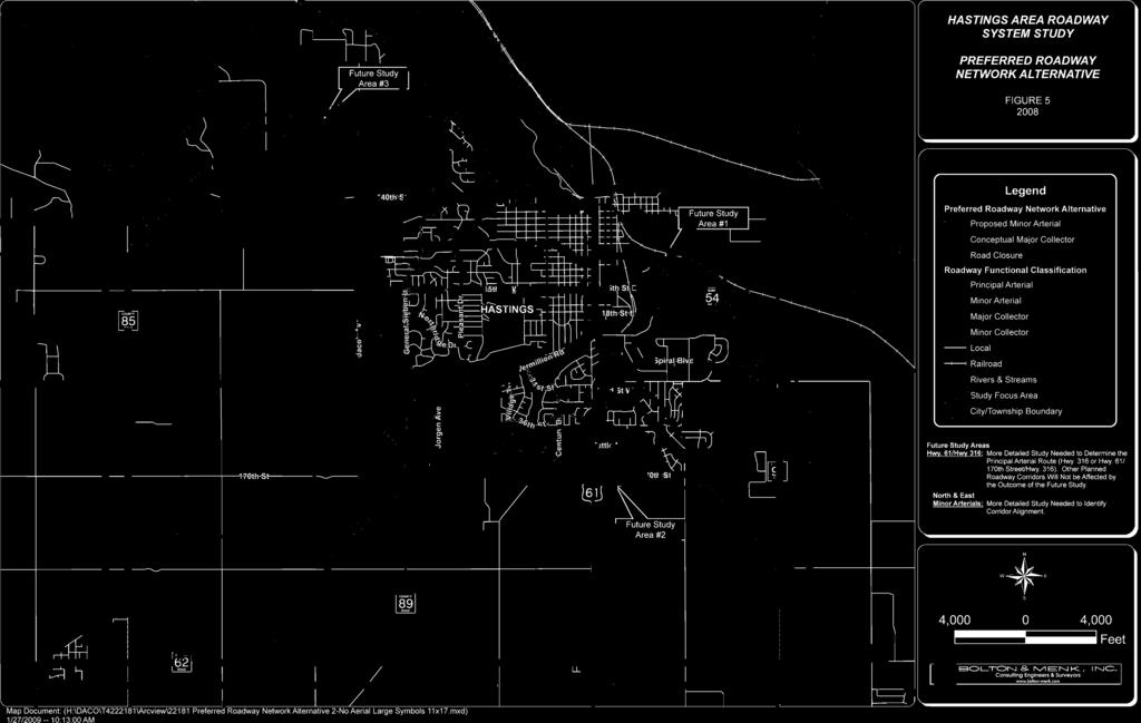
4 EXECUTIVE SUMMARY The Hastings area is anticipated to reach a population over 30,000 by the year Highways 61 and 55 are currently congested roadways. To accommodate existing and anticipated future traffic, Dakota County and the City of Hastings, together with representatives from Marshan Township, Nininger Township, Metropolitan Council, and Minnesota Department of Transportation (Mn/DOT), have partnered together to develop a long term roadway system vision to serve existing and future growth. The overall Study Goal was to identify a long term vision for a system of collector and arterial roadways in the potential growth areas south and west of the city that would provide for the future development of a safe and efficient system of roadways in the Hastings area. The three specific study goals were that the system vision be technically feasible, economically viable, and environmentally compatible. Six (6) roadway network alternatives were identified and evaluated based on 13 study objectives. The identified Preferred Roadway Network alternative was a hybrid of two alternatives studied and is displayed in Figure 5 found on the following page. Based on current governmental funding, it is anticipated that the roadway network vision will be developed as land use changes are proposed. Section IV(B) includes implementation responsibilities for study participants to achieve the Preferred Roadway Network. Figure 5 also identifies three areas where additional study is recommended. The outcomes of these studies are not expected to impact the Preferred Roadway Network. Study Area #1 Eastern Minor Arterial Corridor. It is recommended that the eastern minor arterial corridor extend along CR 91 between TH 316 on the south and CR 54 on the north. The purpose of this study would be to identify the minor arterial corridor alignment and necessary safety and capacity improvements between the intersection of CR 54/91 and TH 61. The findings of this study will provide important information to be considered during the analysis associated with Study Area #2. Study Area #2 Principal Arterial Designation. A focused study is necessary to determine whether TH 61 to TH 316 or TH 61 to 170th Street to TH 316 should be designated and improved with design characteristics consistent with a principal arterial route, including modifications to encourage regional traffic to use the principal arterial. Study Area #3 Northern Minor Arterial Corridor. The purpose of this study would be to identify an east-west minor arterial corridor alignment that should be preserved and developed as land use changes occur in the area. The study limits are recommended to extend approximately ¼ mile north of CSAH 42 and ¼ mile south of 140th Street. Prepared by Bolton & Menk, Inc. (T ) Page iii


5
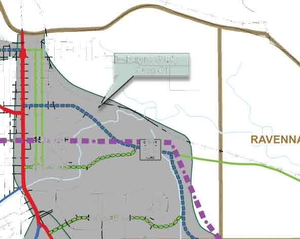
6 I. INTRODUCTION & BACKGROUND The city of Hastings is located in northeast Dakota County on the south side of the Mississippi River. State Highways 55 and 316, US Highway 61, together with County State Aid Highways (CSAH) 46 and 47, accommodate thru-trips, as well as trips beginning or ending in the Hastings area. To accommodate existing traffic and anticipated future traffic, Dakota County and the City of Hastings, together with representatives from Marshan Township, Nininger Township, Metropolitan Council, and Minnesota Department of Transportation (Mn/DOT), have partnered together to develop a long term roadway system vision in the Hastings area to serve existing and future growth. A. STUDY GOAL & STUDY AREA The overall Study Goal is to identify a long term vision for a system of collector and arterial roadways in the potential growth areas south and west of the city that will provide for the future development of a safe and efficient system of roadways in the Hastings area. The three specific study goals are that the system vision be technically feasible, economically viable, and environmentally compatible. The study area is bound by the Mississippi River on the north, Pleasant Drive and 15th Street on the northeast, approximately County Road (CR) 85, approximately CR 91, and CR 62/190th Street alignment. The Study area boundary is illustrated in Figure 1. B. NEED FOR STUDY The City of Hastings, Dakota County, Mn/DOT, and area townships agree that given current congestion levels, it is necessary to plan for a system of roadways to support existing and planned growth in northeast Dakota County. Figure 2 displays issues identified relative to the existing transportation system. Trunk Highway (TH) 61 is a north/south corridor extending from southeast Minnesota generally along the Mississippi River. The corridor goes through downtown Hastings across the river at the busiest 2-lane bridge in Minnesota. Through the city of Hastings, the corridor includes multiple intersections and direct driveway accesses. The route is functionally classified as a principal arterial north of TH 316. North of Hastings, the route generally parallels I-35 and connects the cities of Cottage Grove, St. Paul Park, Newport, St. Paul, Maplewood, White Bear Lake, Hugo, Forest Lake, and Wyoming where TH 61 and I-35 converge. North of Duluth, TH 61 follows the Lake Superior shoreline and extends into Canada. Prepared by Bolton & Menk, Inc. (T ) Page 1
7 TH 55 is an east west principal arterial roadway. It provides connectivity from Hastings, through Minneapolis and its western suburbs of Golden Valley and Plymouth, and terminates at TH 75 near the Minnesota-North Dakota border. Within the city of Hastings, TH 61 and TH 55 are currently congested roadways. The traffic signal controlled intersections, overall access spacing, and limited expansion potential on both corridors limit their ability to handle higher volumes of traffic. TH 316 is a principal arterial route providing connectivity from TH 61 west of Red Wing to TH 61 south of 26th Street in Hastings. TH 316, between Tuttle Drive and TH 61, transitions through a variety of geometric configurations. This area also includes several property accesses and intersections. Within the city of Hastings, this roadway provides important regional traffic mobility, and due to adjacent land uses, the route also provides local circulation. CSAH 46 is an east-west minor arterial corridor through central Dakota County. It provides connectivity between I-35 in Lakeville and TH 61 in Hastings. CSAH 47 provides continuity from Northfield northeast to Hastings. CSAH 46 and CSAH 47 converge east of General Sieben Drive. CSAH 46/47 (Vermillion Road) carried 10,700 vehicles per day in 2005 between TH 61 and Pine Street. This traffic volume is approaching the capacity of the roadway. Future traffic projections indicate 2025 average annual daily traffic (AADT) volumes are expected to increase to approximately 18,100 vehicles per day as this area of the city continues to grow. Appendix B details limitations of the CSAH 46/47 area. There is a lack of north-south minor arterial roadways within the study area. Minor arterial roadways in urban areas are recommended by the Metropolitan Council to be spaced 1 to 2 miles apart in developing areas. In the approximate 9 miles between TH 61 and TH 52, CSAH 47 is the only minor arterial roadway. However, it does not provide north-south continuity. General Sieben Drive, Pleasant Avenue, and Pine Street are major collector roadways in Hastings that provide connectivity between CSAH 46 and TH 55. Their design and overall continuity makes them appropriate for local traffic. As a result, regional northsouth traffic, typically provided by a minor arterial roadway, isn t accommodated. Safe and efficient roadway route choices for local and regional traffic are necessary to reduce overburdening the existing highway and city street system. The Metropolitan Council estimates the population in the Hastings area to increase from approximately 20,000 in 2000 to 32,500 by The City has been considering the magnitude of this growth during the development of their 2030 Comprehensive Plan. It is anticipated that 2030 land uses will extend south to 170th Street and west to Jacob Avenue as illustrated in Figure 3. Within Marshan, Nininger, and Vermillion Townships, land uses are anticipated to consist of primarily agricultural and open space activities, as well as limited single family residential opportunities. Based on the potential growth in the Prepared by Bolton & Menk, Inc. (T ) Page 2
8 Hastings area, it is necessary to plan for future transportation improvements to serve local and regional traffic. Findings of the Highway 316 Bypass Feasibility Partnership Study completed in 2002 indicated that without improvements to the arterial roadway system, continued growth within the city of Hastings and the region would result in increased traffic volumes on the local street system and congestion on the arterial roadways. The study identified that the construction of a TH 316 bypass segment between TH 316 and TH 61 along the 170th Street alignment would improve the safety of the existing TH 316 segment north of Tuttle Drive by removing regional traffic from the corridor. The study identified that the bypass would improve regional mobility on the new corridor and TH 61. Further study of the arterial and collector system in the Hastings area was recommended. Coordinating corridor routes and land use planning will result in a more sustainable community. Developing a comprehensive roadway network vision provides an opportunity to avoid negative environmental, social, and economic impacts. Rapidly increasing cost of land, future growth pressures, and traffic projections in the Study area identify the need for corridor planning. C. AGENCY COORDINATION AND PUBLIC INVOLVEMENT PROCESS Agency coordination and public involvement were identified as key components to the success of the Study. These efforts provided the public and local agencies with continuing opportunities to be involved in the identification of preferred roadway system. Input from affected agencies and the public was important in lending credibility to key decisions made during the planning process. A Project Management Team (PMT) was organized consisting of representatives from the City of Hastings, Dakota County, Dakota County Soil and Water Conservation District, Marshan Township, Nininger Township, Vermillion Township, Minnesota Department of Transportation (Mn/DOT) - Metro District, and Metropolitan Council. Members of the PMT were responsible for representing their agency s interests and reporting back information to their agency. Seven PMT Meetings were held over the course of the study. The responsibilities of the PMT included: Agree upon study goal, objectives, and evaluation criteria Identify and locate known environmental and cultural resources that may affect potential roadway network alignments Identify, review, and evaluate corridor alternatives Review and discuss public input Identification of a preferred roadway system alternative Develop consent on implementation strategies and responsibilities Prepared by Bolton & Menk, Inc. (T ) Page 3
9 Open House Meetings were held to provide a forum for the public to participate with local communities and the PMT on the development of roadway system alternatives. Notice for the meetings was provided to residents and businesses by means of press releases, the Dakota County website, and direct mailings of newsletters. The first meeting was held on August 28, The handout Rationale for Study, Goals & Objectives, Evaluation Criteria (Appendix A) was used to describe information about the Study. The objective of the first meeting was to explain the study objectives, present existing information regarding regional and local transportation problems and needs, present opportunities and challenges that may help determine potential transportation improvements, and receive public input on other issues. A second meeting was held on January 17, The purpose of the second meeting was to present and receive public input on the potential regional and local transportation alternatives necessary to accommodate the projected long-term growth needs in the Hastings area. The final open house was held on July 15, The focus of this meeting was to present and receive input on the preferred roadway network alternative. Summaries of the meetings and written comments received from the open house meetings are included in Appendix C. County Website. The Dakota County website was utilized as a means to advertise public involvement opportunities and display information presented at open house meetings. This provided the opportunity for the public to keep abreast of the Study s progress. Hastings City Council Meeting. A meeting was held on August 4, 2008 to present the Study findings and recommendations. The City Council approved Resolution supporting the Study conclusions. Nininger & Marshan Township Meetings. Separate meetings were held with Marshan Township on July 1, August 19, December 23, 2008, and January 12, Meetings with Nininger Township were held on July 7, August 19, September 11, December 23, 2008, and January 12, The purpose of these meetings was to provide opportunities for the townships, the county, and the study consultant to understand each others perspectives on the transportation issues related to urbanized growth of Hastings. Both townships indicated they had reservations about the growth that the city of Hastings was planning for by As a result, both townships decided not to approve resolutions supporting the Study. The city s planned growth for the year 2030 is consistent with Hastings System Statement provided by the Metropolitan Council. The System Statement outlines the city s responsibility for accommodating their share of the anticipated growth in the Twin Cities Metropolitan region. It was determined through this study that to ensure a safe and efficient system of roadways in the future, a vision for arterial and collector roadways must be identified prior to additional development occurring in the area. Refinements were made to the vision to remove future collector roads located outside of Hastings identified 2030 growth boundary, consistent with township input. Additionally, Prepared by Bolton & Menk, Inc. (T ) Page 4
10 Jacob Avenue between TH 55 and CSAH 42 was identified as a major collector corridor to reflect its more local role in the area. Ultimately, the vision identified in this study and illustrated in the Preferred Roadway Network Alternative will appropriately accommodate future development as it is currently planned. It is the intention of the county and the city to preserve these future collector and arterial roadway corridors as land use changes occur. Prepared by Bolton & Menk, Inc. (T ) Page 5
11 II. OBJECTIVES & EVALUATION CRITERIA This planning level Study identified and evaluated potential roadway system alternatives, and screened alternatives based on their ability to be technically feasible, economically viable, and environmentally compatible. Objectives and evaluation criteria were identified to assess the alternatives ability to achieve the study goals. Appendix E illustrates the evaluation matrix used in this study. A. TECHNICALLY FEASIBLE An important consideration for any roadway network alternative was that it be technically feasible. For purposes of this Study, this was defined as providing safe and efficient movement of people, goods, and services. Following were the technically feasible objectives and evaluation criteria considered.! " #$" %& #$'( )'$*(%$"' #'+) $')(!,*' $" $' -. //0 1! 12 $6)'"''( %(' #'+) $')(&$6$, 1!1$( " #-'( ) 5 (6')'$* $6)'"3' ($') (!,*''( $"$)' :$( 97#('!(! 91 #('!($($"' #'+)$') *$5 0,"')))(,' -$"!)(+5 $(%&++($' *$5 (%#())#$((!,*%( )(#)$%%'##'#&)$'( $3' ($')4 ())#$((!,*#( #$'( $"$)' $)!5!( ' #'+)$')6*+('!' - %%'#' $(&$ )$ $' ('!' #'+)$')(&$$"$#(&)!6'5 +(!$(5 $ %&$&$)!5!6$, /$"$$47 $" $$ ('!(++($& '$*$(!&###)(#$'( $(65 (#( '$ $,'$"$"$-$!85 ')+#' --&'!)' %('5 +(!%$*4 5 (6')'$*(%$"#('!( ('!())#$($$#( #$''$*$"$5 ' $' )!##,"') #"'' -' #'+)$')5 (6')'$*%& #$'( 9('!#('!($"$(%%(+$'( $(!'$(%%'#' $)*#( #$ $"5,'$"$")(#$'(,"$"'$'+6-' 4! $#('!(''( $"$# 6!)(+!$(%)*4%%'#' $)* 5 $$";'$' -4 %&$&$<,$$)!5!( 91 6$, $#('!(''( $"$# 6!)(+!$(%)*4%%'#' $)* 5 $$";'$' -4 %&$&(&$",$< ($"$$)!5!( 976$, //! $'%*(&$%(%4 %%'#' $' $#$'(,'$"$"' #'+) $')(!,*4 5 ' $' ##+#' -( $"' #'+)$'). 5 ')+#' -(%'5 * $#$'( 2 9('!#('!(''( $"$(%%(+$'( $(!'$(%%'#' $)* #( #$$"5,'$"$")(#$'(,"$"'$'+6-' 4! /('!+&6)'#$$##4 $%%'##( $()#( '$ $,'$"$" :($(& $* +($$'( ) %(3' ($')(!,*.= 5 ') +#' -(%'5 * $#$'( 0> 5 ')+#' -(%#(!* $#$'( 2 Prepared by Bolton & Menk, Inc. (T ) Page 6
12 9 $6)'"''( (%;'$' -!%&$&#())#$((!,*$( ##(5 5 (!$$'+6-' ' -!!' -,'$"' $"'$*(% $' - / $-$$"5 (5 $(%$'+ ' $"(!,* $,(:$"(&-" *$5 #( $' &'$*! #( #$''$* 9#(- '?45 ' $' $"()(%;'$' -'$*(%$' -#())#$( (!,*.- )'6 '0) $'0/$"$$01$" $$2 9;+!())#$($$*$5 $(!)(+' -$(+(5 ($ #( #$''$*,'$"$"#'$*4 $($"$')(!,*.= $(5 ') +#' -6$, 3@(())#$((!,*2 /('!#( $' &'$*(%(!,*6*5 ' '5 '?' -@(-' ' #'+)4 $')(!,* /('!%4 %%'#' $#(' -(%$"' #'+)4 3' ($') (!,* /('!(5 ' '5 '?;#')*#( $' &(&)(#)(!,* /9! $'%*;'$' -4%&$&%& #$'( 4@&'!'#$'( )+( '6')'$'%( #"(!,*' $"$&!* B. ECONOMICALLY VIABLE The ability to achieve an economically viable roadway network was an important study goal. This included considering the ability for local, regional, and state government to strategically invest public dollars, while preserving and promoting residential, agricultural, and business activities. 1 3' '5 '?(!,*#( $&#$'(!'-"$<(%<,*#($ 7 ('! (++($& '$*%( #('!($(6$6)'"! $"(&-"!)(+5 $!' ' '$'$' A 3' $' ##'6')'$*(%;'$' - 6&'!#''#!$' $'( B 3' $' (++($& '$*%(C&)'$*!)(+5 $(++($& '$' ('!(++($& '$*%( #( $' &!-'#&)$&) (+$'(! " ## 13;'5 '?&(%;'$' -(!,*)'- 5 $06'!-4'-"$<(%<,* 13' '5 '?$" &5 6(%+($ $')6&' 4 '! $'))(#$'( 1('!(5 ' '5 '?%&$&(!,*)'- 5 $','$"(') ($ &'$6)%((!,*#( $&#$'( (: (, "?!(&,$'$ 193' '5 '?!%(,6'!-($"5 '))'( '4 ($"#($)* $&#$& 7(#$(!,*,'$"' -(,$"6(&!*(!@&$-(,$" 6(&!*$(' #)&!#'$'#)(!,*#( #$'( A('!)(#)4#())#$($$##$(+(+$'$"$%%'#' $)* #( #$$($'+('-' B3' '5 '?' -(%)-!)(+5 $+(+$' ('!(5 ' '5 '?'5 +#$4 ' -(%+'5 %5 )!(&$'!(% $"#'$*-(,$"6(&!* ('!(5 ' '5 '?'5 +#$$(;'$' --'#&)$&))!''-$'( *$5 Prepared by Bolton & Menk, Inc. (T ) Page 7
13 C. ENVIRONMENTALLY COMPATIBLE While accommodating regional and local transportation needs were important Study goals, it was recognized that environmental and cultural resources needed to be carefully reviewed and impacts avoided or minimized. To be considered environmentally compatible, a roadway system alternative avoids or minimizes impacts to known environmental features and known sensitive areas or groups of people. Following are the objectives and evaluation criteria considered. ('!(5 ' '5 '?'5 +#$$( '( 5 $)%$&' $" $' - ('!'5 +#$$(: (, '$'(-(&+(% +(+) ('!(5 ' '5 '?'5 +#$$( +:)!! " ## ('!(5 ' '5 '?,$)!4 %)((!+)' '5 +#$ ('!(5 ' '5 '?'5 +#$$(C&)'$*,((!!0-'( ))* '- '%'# $#()(-'#)4: (, "6'$$(%$"$!(! -!+#' ('!(5 ' '5 '?,#(' -(%$"5 '))'( ' ('!(!,*)'- 5 $( ( : (, "'$('#+(+$'0 #5 $'0: (, #"()(-'#)'$(-(&+(%+(+) ('!+:4 $').#$'( 9%2'5 +#$ An Environmental and Cultural Resources Overview Memorandum, including exhibits of known natural and cultural resource areas, can be found in Appendix D. The primary use of this information was to develop alternatives that avoided or minimized impacts to resources or sensitive areas. This report also provides a basis for understanding potential environmental and cultural resource impacts associated with each roadway system alternative. Known environmental features evaluated included floodplains, wetlands, woodlands, trails and parks, Mississippi River Critical Area, Mississippi National River and Recreation Area, endangered or threatened species, shoreland districts, Vermillion River Watershed, prime farmlands, soil suitability for roadway construction, and agricultural preserves. Known sensitive areas evaluated include cemeteries, historic sites, archaeological sites, leaking underground storage tanks, and hazardous waste sites. It is anticipated that further review of resources may be required under federal laws or state statutes depending on funding for construction or permitting issues. Prepared by Bolton & Menk, Inc. (T ) Page 8
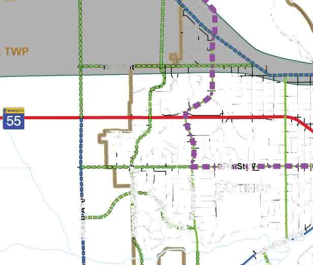
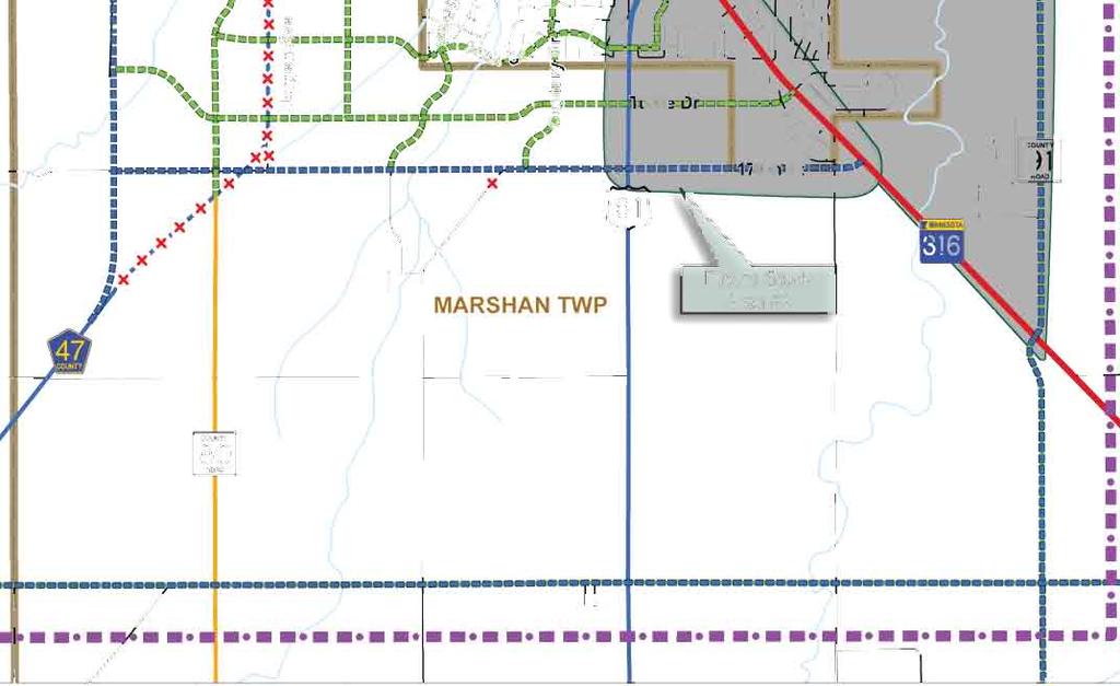
14 III. ROADWAY NETWORK ALTERNATIVES Six collector and arterial roadway network alternative concepts were developed. These alternatives were considered and evaluated based on the various factors identified in Sections I and II and are displayed in Figures 4A through 4F. A. ALTERNATIVES Developing the long-term roadway network vision began with the establishment of the minor arterial roadway system. Metropolitan Council standards recommend minor arterial roadways be spaced 1-2 miles apart in an urban or urbanizing area. These roadways have an emphasis on mobility rather than access, and they accommodate trips longer than 5 miles. Roadways of this functional classification are generally designed to have a 45 to 55 mile per hour travel speed. Intersections on minor arterial roadways are recommended to be spaced at ½ mile intersections with major collector roadways. A goal in developing the minor arterial system vision was to improve connections between principal (i.e. TH 55, TH 61, and TH 316) and minor arterial roadways. The alternatives developed included two primary variations to the minor arterial system vision, as well as two hybrid variations. Variation #1 develops a new north-south minor arterial corridor using Jacob Avenue. It maintains the east-west minor arterial at CSAH 46, and establishes a new east-west minor arterial corridor at the 170 th Street alignment. Roadway network Alternatives A and B are within this variation. Variation #2 develops a new east-west minor arterial corridor using CSAH 46 and the 170 th Street alignment. A new north-south minor arterial corridor would be developed along the Jacob Avenue alignment and connect to CSAH 47 via CSAH 46. Roadway network Alternatives C and E are within this variation. Hybrid #1 roadway network Alternative D is based on Variation #2, but the minor arterial designation on existing CSAH 46/47 between Pleasant Avenue and TH 61 remains. Hybrid #2 roadway network Alternative F is similar to Variation #1, but it includes a new east-west minor arterial at CSAH 42 and a new north-south minor arterial using CR 91, CR 54, and 10 th Street. Prepared by Bolton & Menk, Inc. (T ) Page 9
15 With the framework of minor arterial roadways, major collector roadways were incorporated. According to the Metropolitan Council, major collector roadways in urban areas should be spaced ½ to 1 mile apart. These roadways allow for the movement of local traffic and provide interconnectivity between neighborhoods, business concentrations, and arterial roadways. Access to these roadways is recommended to be spaced at ¼ mile intervals. Following are descriptions of the roadway network alternatives. A larger version of each alternative can be found in the Figures section of this report. 8 9 Alternative A includes a new north-south minor arterial corridor using Jacob Avenue and CR 89. It also includes a new east-west minor arterial along the 170 th Street alignment between Jacob Avenue and TH 316. CSAH 46 would maintain its current alignment to TH 61, and CSAH 47 would terminate at the new north-south minor arterial. D8 9D Alternative B includes a new north-south minor arterial corridor using Jacob Avenue and CSAH 47. Like Alternative A, it includes a new east-west minor arterial along the 170th Street alignment between Jacob Avenue and TH 316. CSAH 46 would maintain its current alignment to TH 61, and CSAH 47 would follow the Jacob Avenue alignment to TH Alternative C would include CSAH 46 maintaining its current alignment to Pleasant Avenue, and curve south and east to follow the 170th Street alignment to TH 316. CSAH 47 would follow the existing alignment to CSAH 46. A new north-south minor arterial corridor along Jacob Avenue between TH 55 and CSAH 46 would also be incorporated. 8 9 Alternative D includes a new north-south minor arterial corridor using the Jacob Avenue alignment between CSAH 46 and TH 55, as well as maintain connections between CSAH 46 and CSAH 47 on the Jorgen Avenue alignment. CSAH 46 would maintain its current alignment to TH 61. CSAH 47 would follow the 170th Street alignment to TH Alternative E includes CSAH 46 maintaining its current alignment to General Sieben Drive, and curving south along Jorgen Avenue and east to follow the 170th Street alignment to TH 316. CSAH 47 would follow its existing alignment and terminate at the new CSAH 46 alignment. A new north-south minor arterial corridor using the Jacob Avenue alignment between CSAH 46 and TH 55 would also be incorporated. Prepared by Bolton & Menk, Inc. (T ) Page 10
16 8 9 Alternative F includes a new north-south minor arterial corridor using Jacob Avenue and CR 89. CSAH 46 would maintain its current alignment to TH 61, and CSAH 47 would follow the 170th Street alignment to TH 316. A new east-west minor arterial corridor following CSAH 42 and a new north-south minor arterial corridor following CR 91, CR 54, and 10th Street would be part of this alternative. A seventh alternative was developed after Open House #2 based on comments received from Goodhue County to maintain direct continuous routes. This alternative maintained continuity between CSAH 47 northeast to CSAH 46, CR 89 to Jacob Avenue, and CSAH 46 to 170 th Street. The PMT dismissed this alternative, because the minor arterial corridors would be spaced closer than 2 miles apart as identified in Metropolitan Council guidance. Additionally, it was noted that the corridors could result in more challenges for future development on adjacent properties based on how they diagonally bisect parcels. B. RATING SYSTEM The criteria outlined in Section II were used to evaluate alternatives and identify the likelihood to achieve the outlined objectives. Additionally, a rating was applied to distinguish the primary differences between the alternatives. This rating system is defined as follows No Difference in Roadway Network Alternatives Rating is Similar When Compared to Other Alternatives Rating is a Strength When Compared to Other Alternatives Rating is a Weakness When Compared to Other Alternatives C. ALTERNATIVE COMPARISON FINDINGS ADVANTAGES & LIMITATIONS Of the 30 evaluation criteria considered, 16 ratings were similar or had no difference when compared to other alternatives. The remaining 14 criteria represent the primary differences between the alternatives. These areas were Technically Feasible Objective 3: Establish a Minor Arterial roadway vision that links the CSAH 47 and 46 corridors to the principal arterial system, while allowing the development of a supportive system of collector roadways for local traffic circulation Technically Feasible Objective 5: integrate the movement of trips in the roadway network through system continuity & connectivity Prepared by Bolton & Menk, Inc. (T ) Page 11
17 Economically Viable Objective 6: minimize roadway construction & right-of-way costs Environmentally Compatible Objective 11: avoid or minimize impacts to environmental features new Vermillion River crossings Details of the ratings by objective and evaluation criteria can be found in Appendix E. Following is a summary of the three goals. D When considering which alternatives best meets the goal of being technically feasible, Alternative F (Figure 4F) rates higher than the other alternatives, followed by Alternatives A and B. The Metropolitan Council 2030 Regional Travel Demand Model was used to estimate each alternative s ability to reduce regional travel demand on TH 55, TH 61, and TH 316. The findings indicate that a significant amount of trips on TH 316 are destined to Hastings or across the TH 61 bridge. Regional trips beginning from the southeast and destined to the northwest through the Hastings area (and vice versa) are found to not represent a significant portion of the regional travel demand on TH 316. The regional travel demand modeling analysis identifies that Alternative F is more effective than Alternatives A or B at providing efficient options to connect drivers to locations where their trips begin or end and relieving regional travel demand on the principal arterial roadways. This is because Alternative F includes minor arterial corridors on the north, south, east, and west sides of the Hastings area, accommodating regional and local travel demand and providing the ability for travelers to avoid congestion on the principal arterial routes to reach their desired destinations. The other alternatives evaluated do not contemplate minor arterial corridors on the north or east sides of the City. The traffic modeling methodology for this study can be found in Appendix F. As an interim solution for Alternatives A, B, F, Alternative D is identified as a possible option, because of the existence of Jorgen Avenue. In the long term, Alternative D is not as effective in meeting travel demand needs due to the lack of north-south continuity of Jacob Avenue. Alternatives C and E do not meet east-west or southwest to northeast travel demand. They also lack continuity due to jogs and curves in corridor alignments. 3 D The evaluation considers how well the alternatives could achieve an economically viable roadway network. It was found that more poor soils are likely to be encountered in Alternatives C, D, and E than the other alternatives. Alternatives B and C have been identified as requiring the least new right-of-way and Alternative F Prepared by Bolton & Menk, Inc. (T ) Page 12
18 requires the most. This is because minor arterial corridors are not contemplated on the north or east sides of the City in the other alternatives. Alternatives A, B, and F require a new Vermillion River crossing, resulting in additional project costs. The curves on Alternatives C and E could result in more challenges for future development on adjacent properties. Based on the current funding situation at the local, county, and state level it is anticipated that new roadways would be achieved when land use changes and/or development occurs. Overall, Alternatives A, B, and F rate higher than the other alternatives. 3 3 D Alternatives were developed to avoid existing known environmental and cultural resources described in Appendix D. While the Vermillion River is not designated as a trout stream within the study area, Alternatives A, B, and F require a new Vermillion River crossing, resulting in additional environmental impacts and lower ratings than Alternatives C, D, and E. Environmentally sensitive habitats and protected environmental features, as well as challenging terrain, exists east of TH 316 in the Sand Coulee Flowage area. These features limit development potential. They also limit the ability and need to provide additional roadway corridors between TH 316 and CR The following graphic provides a summary comparison between each alternative s ability to meet the study goals of being technically feasible, economically viable, and environmentally compatible. $ % & '( ) *+, *+ -. *. $ * $ * $ % ) *) ''$ & *) '' *) )$ $',$"( )*)$ $'$"$#( '!5 '($')#('!(( $" ($"!$'!(%$"$' - Prepared by Bolton & Menk, Inc. (T ) Page 13
19 IV. PREFERRED ROADWAY NETWORK ALTERNATIVE After evaluating comments received at Open House #2, the PMT convened to identify a preferred roadway system alternative. The study confirmed that TH 55, TH 61, and TH 316 provide appropriate connectivity to other principal arterials and meet Federal Highway Administration (FHWA) spacing guidelines. As a result no new principal arterial corridors are recommended in the Hastings area. Through a process of elimination, the PMT agreed that a hybrid of Alternative B and Alternative F best meet the study objectives. Following were the minor arterial features of Alternative B and F that were merged together to create the Preferred Roadwork Network Alternative B north-south continuity with CSAH 47 to Jacob Avenue and east-west continuity of both CSAH 46 and 170 th Street Alternative F incorporation of route north of TH 55 east to TH 61 and a route from TH 316 on the east side of the City of Hastings to TH 61 The Preferred Roadwork Network can be found in Figure 5. It also includes the extension of the minor arterial designation on Jacob Avenue north of TH 55 to the northern minor arterial. Revisions were also developed to the major collector routes in the area bound by CSAH 46, 170th Street, Jorgen Avenue, and Jacob Avenue to improve local traffic circulation between future neighborhoods. As additional growth occurs in the Hastings area and to assist in managing travel demand on these routes, providing choices for travelers to connect with where their trips begin and end will be of the upmost importance. This can best be accomplished by developing the Preferred Roadwork Network as land use changes occur and managing access to these corridors consistent with FHWA standards. A. FUTURE STUDY AREAS Additional study is recommended at three different locations within the study area. These locations are illustrated on Figure E It is recommended that the eastern minor arterial corridor extend along CR 91 between TH 316 on the south and CR 54 on the north. The purpose of this study would be to identify the minor arterial corridor alignment between the intersection of CR 54/91 and TH 61. The recommended study limits would be approximately 18 th Street on the south and the railroad tracks on the north. The scope of this study should include an analysis of the geometric improvements necessary to provide appropriate mobility through the existing built environment on the east side of Hastings. Consideration and assessment of impacts should include pedestrian safety associated with street crossings, especially near Kennedy Elementary School and Smead Manufacturing, and overall traffic operations with the existing one-way streets (Tyler and Ramsey). The findings of this study will provide important information to Prepared by Bolton & Menk, Inc. (T ) Page 14
20 be considered during the analysis associated with Study Area #2. Recommended study partners include the city of Hastings, Dakota County, Marshan Township, Mn/DOT, and potentially Ravenna Township. 8E A focused study is necessary to determine whether TH 61 to TH 316 or TH 61 to 170 th Street to TH 316 should be designated and improved with design characteristics consistent with a principal arterial route. This study may also include modifications to encourage regional traffic to use the principal arterial. Other planned roadway corridors identified in the Preferred Roadway Network would not be impacted by the outcome of this future study. Recommended study partners include Mn/DOT, city of Hastings, and Dakota County. 3 8E The purpose of this study would be to identify an east-west minor arterial corridor alignment that should be preserved and developed as land use changes occur in the area. The study limits are recommended to extend approximately ¼ mile north of CSAH 42 and ¼ mile south of 140 th Street. The scope of this study should include the development of a conceptual layout and profile, identification of primary and secondary intersections, and approximate grading limits. This information would allow for the corridor to be constructed as land use changes occur. Recommended study partners include Dakota County, city of Hastings, Nininger Township, and Mn/DOT. B. IMPLEMENTATION The intent of this section is to describe the understanding shared by the City of Hastings, Dakota County, Marshan Township, Nininger Township, and Mn/DOT as to the respective responsibilities of each for preserving and ultimately developing the Preferred Roadwork Network. The following identifies the tasks and parties responsible for implementation of the Preferred Roadway Network Include the Preferred Roadway Network in Transportation and/or Comprehensive Plans (County, City, and Townships) Ensure development is consistent with the objectives outlined in this Study (all) Consistent with city standards, preserve 80 of right-of-way for major collector corridors; consistent with Dakota County standards, preserve 150 for minor arterial corridors (all) Prepared by Bolton & Menk, Inc. (T ) Page 15
21 Maintain ¼ mile access spacing on major collector roadways and ½ mile spacing of primary intersections and ¼ mile spacing of secondary intersections consistent with Dakota County standards on minor arterial roadways (City and Townships) Plan for and accommodate pedestrian and bicycle facilities in the development of collector and arterial roadways (City and County) Incorporate identified minor arterial corridors in Dakota County s Road Plat Review Needs Map (County) Require the completion of appropriate environmental reviews as required by state or federal law (County and City) Prepared by Bolton & Menk, Inc. (T ) Page 16
ARGENTA TRAIL (CSAH 28/63) REALIGNMENT SOUTH PROJECT (CP 63-25)
 REALIGNMENT SOUTH PROJECT (CP 63-25)") ARGENTA TRAIL (CSAH 28/63) REALIGNMENT SOUTH PROJECT (CP 63-25) Preliminary Design Report February 2015 Prepared For: City of Inver Grove Heights Dakota County Prepared By: Kimley-Horn and Associates,
ARGENTA TRAIL (CSAH 28/63) REALIGNMENT SOUTH PROJECT (CP 63-25) Preliminary Design Report February 2015 Prepared For: City of Inver Grove Heights Dakota County Prepared By: Kimley-Horn and Associates,
PROJECT BACKGROUND. Preliminary Design Scope and Tasks
 PROJECT BACKGROUND Preliminary Design Scope and Tasks The purpose of this Study is the development of preliminary designs for intersection improvements for Trunk Highway (TH) 36 at the intersections of
1.0 INTRODUCTION 1.1 TH 14 WEST STUDY AREA Project Description Functional Classification Purpose of the Project
 1.0 INTRODUCTION 1.1 TH 14 WEST STUDY AREA 1.1.1 Project Description The Trunk Highway (TH) 14 West Corridor is a two-lane roadway approximately 22 miles in length. Located in Nicollet County, the corridor
PREPARED FOR: PLATTEVIEW ROAD CORRIDOR STUDY EXECUTIVE SUMMARY
 PREPARED FOR: PLATTEVIEW ROAD CORRIDOR STUDY EXECUTIVE SUMMARY SEPTEMBER 2016 Introduction The Platteview Road Corridor Study was led by the Metropolitan Area Planning Agency (MAPA) with assistance from
Mississippi Skyway Preliminary Engineering Report
 EXECUTIVE SUMMARY Mississippi Skyway Preliminary Engineering Report CITY OF RAMSEY, MINNESOTA DECEMBER 2014 City of RAMSEY EXECUTIVE SUMMARY Project Need and Intent The Mississippi Skyway pedestrian bridge
MODEL ACCESS MANAGEMENT PLAN MINNESOTA TRUNK HIGHWAY 7 COMPREHENSIVE PLAN AMENDMENT (HUTCHINSON SEGMENT)
") MODEL ACCESS MANAGEMENT PLAN MINNESOTA TRUNK HIGHWAY 7 (HUTCHINSON SEGMENT) COMPREHENSIVE PLAN AMENDMENT INTRODUCTION. The purpose of this plan is to provide consistent access management in the Trunk
MODEL ACCESS MANAGEMENT PLAN MINNESOTA TRUNK HIGHWAY 7 (HUTCHINSON SEGMENT) COMPREHENSIVE PLAN AMENDMENT INTRODUCTION. The purpose of this plan is to provide consistent access management in the Trunk
RESOLUTION NO. R Refining the route, profile and stations for the Downtown Redmond Link Extension
 RESOLUTION NO. R2018-32 Refining the route, profile and stations for the Downtown Redmond Link Extension MEETING: DATE: TYPE OF ACTION: STAFF CONTACT: Capital Committee Board PROPOSED ACTION 09/13/2018
Subject: City of Richfield Cedar Avenue Corridor Plan Comprehensive Plan Amendment, Review File No
 Committee Report Business Item No. 2017-21 Community Development Committee For the Metropolitan Council meeting of January 25, 2017 Subject: City of Richfield Cedar Avenue Corridor Plan Comprehensive Plan
This chapter describes the purpose of the Plan, introduces how the Plan is organized and provides contextual background for the Plan.
 Chapter 1: INTRODUCTION Purpose of a Comprehensive Plan The 2040 Comprehensive Plan establishes Medina s vision as a community and sets goals and objectives which guide future decisions and policies. The
NORTH-SOUTH CORRIDOR STUDY EXECUTIVE SUMMARY. Executive Summary
 Executive Summary Background As congestion continues to affect mobility in the region, the Ozarks Transportation Organization (OTO) is particularly concerned with traffic movement. The North-South Corridor
Chapter 1 - General Design Guidelines CHAPTER 1 GENERAL DESIGN GUIDELINES
 CHAPTER 1 GENERAL DESIGN GUIDELINES 1.0 INTRODUCTION This Publication has been developed to provide current, uniform procedures and guidelines for the application and design of safe, convenient, efficient
Existing Transportation System 5-1
 5-1 The Jackson County transportation system is served by several modes of transportation including streets and highways, multi-modal, non-motorized, rail, and aviation. While the focus of the transportation
CHAPTER 7: VISION AND ACTION STATEMENTS. Noble 2025 Vision Statement
 CHAPTER 7: VISION AND ACTION STATEMENTS This chapter presents the vision, policy and action statements that transform the comprehensive planning study, an analysis of Noble s past, future trends and community
Public Hearing. Charlotte County-Punta Gorda MPO - Meeting Rooms A and B March 14, open house at 4 p.m., formal presentation at 5 p.m.
 Public Hearing Charlotte County-Punta Gorda MPO - Meeting Rooms A and B March 14, 2019 open house at 4 p.m., formal presentation at 5 p.m. Welcome to the Public Hearing for the Harborview Road (CR 776)
Corridor Vision. 1Pursue Minnehaha-Hiawatha Community Works Project. Mission of Hennepin County Community Works Program
 1Pursue Minnehaha-Hiawatha Community Works Project Minnehaha-Hiawatha Community Works is a project within the Hennepin Community Works (HCW) program. The mission of the HCW program is to enhance how the
CITY OF CHARLOTTESVILLE, VIRGINIA CITY COUNCIL AGENDA
 CITY OF CHARLOTTESVILLE, VIRGINIA CITY COUNCIL AGENDA Agenda Date: December 16, 2013 Action Required: Adoption of Resolution Presenter: Staff Contacts: Title: James E. Tolbert, AICP, Director of NDS James
Transportation Committee
 Transportation Committee Business Item No. 2013-286SW Meeting date: October 14, 2013 For the Metropolitan Council meeting of October 16, 2013 Subject: Southwest Light Rail Transit (Green Line Extension):
OPEN HOUSE #3. Project Manager Kristi Sebastian, PE, PTOE
 OPEN HOUSE #3 Project Manager Kristi Sebastian, PE, PTOE kristi.sebastian@co.dakota.mn.us 952-891-7100 WHY ARE WE CONDUCTING THE ARTERIAL CONNECTOR STUDY? Dakota County and the cities of Rosemount, Inver
Concept Master Plan. for. Draft of. Wildlife Management Area. Prepared for. June, 2008
 Draft of Concept Master Plan for Vermillion Highlands: A Research, Recreation and Wildlife Management Area Prepared for Vermillion Highlands Steering Committee - Minnesota Department of Natural Resources
State Highway 121 Southwest Parkway. Fort Worth s Transportation Success Story in Design and Cooperation
 State Highway 121 Southwest Parkway Fort Worth s Transportation Success Story in Design and Cooperation Greater Fort Worth Association of Realtors October 24, 2007 Presented by: Dan Lamers, P.E. North
PROJECT STATEMENT LOCATION/DESIGN PUBLIC HEARING. 19 th AVENUE NORTH EXTENSION PROJECT FROM SPRINGDALE DRIVE TO NORTH 2 ND STREET/U.S.
 PROJECT STATEMENT LOCATION/DESIGN PUBLIC HEARING 19 th AVENUE NORTH EXTENSION PROJECT FROM SPRINGDALE DRIVE TO NORTH 2 ND STREET/U.S. 67 HEARING LOCATION: ERICKSEN COMMUNITY CENTER 1401 11 TH AVENUE NORTH
MDX SR 836/DOLPHIN EXPRESSWAY SOUTHWEST EXTENSION
 MDX SR 836/DOLPHIN EXPRESSWAY SOUTHWEST EXTENSION Project Development and Environment (PD&E) STUDY Miami-Dade County, Florida Preliminary Executive Summary Alternative Corridor Evaluation (ACE) Report
METROPOLITAN COUNCIL 390 North Robert Street, St. Paul, MN Phone (651) ; TDD (651)
 ; TDD (651)") DATE: December 20, 2011 METROPOLITAN COUNCIL 390 North Robert Street, St. Paul, MN 55101 Phone (651) 602-1000; TDD (651) 291-0904 TO: Metropolitan Parks and Open Space Commission FROM: Tori Dupre, Senior
DATE: December 20, 2011 METROPOLITAN COUNCIL 390 North Robert Street, St. Paul, MN 55101 Phone (651) 602-1000; TDD (651) 291-0904 TO: Metropolitan Parks and Open Space Commission FROM: Tori Dupre, Senior
Transportation Systems and Utility Infrastructure
 77 Audience Local and regional units of government, Landowners and developers, Community and citizen organizations, and Transportation/utility planners and engineers. Overview Transportation systems and
BeltLine Corridor Environmental Study
 BeltLine Corridor Environmental Study Joint TAC and SAC Meeting December 8, 2008 What We Will Discuss Today Outreach and Agency Coordination Scoping Results Existing Conditions Historical and Archeological
I. DESCRIPTION OF PROPOSED ACTION... 1 A. General Description... 1 B. Historical Resume and Project Status... 2 C. Cost Estimates...
 PROJECT COMMITMENTS SUMMARY... S-1 1. Type of Action... S-1 2. Description of Action... S-1 3. Summary of Purpose and Need... S-1 4. Alternatives Considered... S-2 5. NCDOT Alternatives Carried Forward...
Scope of Services. River Oaks Boulevard (SH 183) Corridor Master Plan
 Corridor Master Plan") Scope of Services River Oaks Boulevard (SH 183) Corridor Master Plan PROJECT AREA The project area consists of the River Oaks Boulevard (SH 183) corridor bounded by SH 199 at the northern end and the Trinity
Scope of Services River Oaks Boulevard (SH 183) Corridor Master Plan PROJECT AREA The project area consists of the River Oaks Boulevard (SH 183) corridor bounded by SH 199 at the northern end and the Trinity
Rosemount Greenway Master Plan Executive Summary. draft. Spring for more information visit
 Rosemount Greenway Master Plan Executive Summary Spring 2012 draft for more information visit www.hkgi.com/projects/dakota INTRODUCTION The Rosemount Greenway Master Plan portrays a vision to establish
HAZARD MITIGATION GOALS AND OBJECTIVES
 SEWRPC Community Assistance Planning Report No. 282, 2nd Edition CITY OF MILWAUKEE ALL HAZARDS MITIGATION PLAN UPDATE Chapter IV HAZARD MITIGATION GOALS AND OBJECTIVES [NOTE: Throughout this plan update
BeltLine Corridor Environmental Study
 BeltLine Corridor Environmental Study Citywide Conversation on Transit and Trails April 2, 2009 Agenda & Introductions Introductions Environmental Study Process Overview of the BeltLine Project BeltLine
CITY OF ANN ARBOR MASTER PLAN. Land Use Element
 CTY OF ANN ARBOR MASTER PLAN Land Use Element June 15, 2009 Prepared by the Ann Arbor City Planning and Development Services Unit and the City of Ann Arbor Planning Commission City Master Plan: Land Use
DRAFT Subject to Modifications
 TREASURE COAST REGIONAL PLANNING COUNCIL M E M O R A N D U M To: Council Members AGENDA ITEM 8 From: Date: Subject: Staff May 19, 2017 Council Meeting Florida Department of Transportation Complete Streets
Issues Requiring Future Study
 Issues Requiring Future Study Transportation planning is an ongoing process that tends to identify new issues as it finds solutions for others. Some issues are so complex that a solution to one problem
Albert Lea. Redevelopment Plan. 701 Xenia Avenue South, Suite 300 Minneapolis, MN Tel: (763) Fax: (763) wsbeng.
 Fax: (763) wsbeng.") Albert Lea Redevelopment Plan 701 Xenia Avenue South, Suite 300 Minneapolis, MN 55416 Tel: (763) 541-4800 Fax: (763) 541-1700 wsbeng.com Albert Lea Redevelopment Plan Table of Contents Composite Districts...
Albert Lea Redevelopment Plan 701 Xenia Avenue South, Suite 300 Minneapolis, MN 55416 Tel: (763) 541-4800 Fax: (763) 541-1700 wsbeng.com Albert Lea Redevelopment Plan Table of Contents Composite Districts...
7.0 SOCIAL, ECONOMIC, AND ENVIRONMENTAL ISSUES
 7.0 SOCIAL, ECONOMIC, AND ENVIRONMENTAL ISSUES The following list of social, economic, and environmental issues have been identified based on a preliminary inventory of resources in the project area, an
Description of Preferred Alternative
 Chapter 2 Description of Preferred Alternative 2.1 Introduction This chapter of the programmatic Sammamish Town Center Sub-area Plan Final EIS provides a more detailed description of the Preferred Alternative
METROPOLITAN COUNCIL 390 North Robert Street, St. Paul, MN Phone (651) ; TDD (651)
 ; TDD (651)") DATE: October 24, 2012 METROPOLITAN COUNCIL 390 North Robert Street, St. Paul, MN 55101 Phone (651) 602-1000; TDD (651) 291-0904 TO: Metropolitan Parks and Open Space Commission FROM: Tori Dupre, Senior
DATE: October 24, 2012 METROPOLITAN COUNCIL 390 North Robert Street, St. Paul, MN 55101 Phone (651) 602-1000; TDD (651) 291-0904 TO: Metropolitan Parks and Open Space Commission FROM: Tori Dupre, Senior
WHAT IS THE PURPOSE OF THE OPEN HOUSE?
 WHAT IS THE PURPOSE OF THE OPEN HOUSE? OPEN HOUSE PURPOSE The purpose of the open house is to provide an update on the study process and introduce the preliminary concept alternatives. The open house provides
Planning Districts INTRODUCTION
 INTRODUCTION To facilitate detailed examination of development prospects for all areas of the community, Delano has been divided into 14 planning districts. The location of these planning districts is
1.0 PROJECT PURPOSE AND NEED
 1.0 PROJECT PURPOSE AND NEED The FasTracks Plan includes the extension of the Central Corridor from its current terminus at 30th/Downing to a connection to the East Corridor commuter rail service planned
SUMMARY. Support the Southeast Arkansas Regional Intermodal Facility.
 SUMMARY THE I-69 LOCATION STUDY The proposed I-69 Location Study from El Dorado to McGehee, Arkansas, represents one section (Section of Independent Utility No. 13) of the nationally designated I-69 Corridor
COLVER ROAD INDUSTRIAL CONCEPT PLAN
 COLVER ROAD INDUSTRIAL CONCEPT PLAN A CONCEPTUAL LAND USE AND TRANSPORTATION PLAN FOR TA-4 AN URBAN RESERVE AREA OF THE CITY TALENT City of Talent Adopted by City Council Resolution No., June, 2015 PART
4-Town Comprehensive Plan DRAFT 7/30/07
 4-Town Comprehensive Plan DRAFT 7/30/07 Acknowledgements ning Committee Town of Harrisburg Norman Roof Randy Nicol Town of Martinsburg Terry Thisse Paul Kelly Town of Montague Jan Bagdanowicz Wendy Perry
Mendota-Lebanon Hills Greenway Master Plan Executive Summary. August draft for more information visit
 Mendota-Lebanon Hills Greenway Master Plan Executive Summary August 2013 draft for more information visit www.hkgi.com/projects/dakota INTRODUCTION The Mendota-Lebanon Hills Greenway Master Plan portrays
Creating Complete Roadway Corridors:
 Creating Complete Roadway Corridors: The AASHTO Guide to Transportation Landscape Architecture and Environmental Design NCHRP Project 15-33 Status Report AASHTO Standing Committee on Design Technical Committee
Master Environmental Servicing Plan & Secondary Plan
 East Side Lands Stage 2 1 Master Environmental Servicing Plan & Secondary Plan Public Information Centre #1 June 16, 2016 Welcome! Today s Agenda Please sign in at the front desk. 5:30 pm 6:30 pm: Open
Dayton Transportation Plan 2016 Update
 WENCK File #3164-30 February 9, 2016 Dayton Transportation Plan 2016 Update Prepared for: City of Dayton, MN 12260 S. Diamond Lake Road Dayton, MN 55327 Prepared by: WENCK Associates, Inc. 1800 Pioneer
Alternatives Development Three conceptual alternatives were developed for the Race Road/Jessup Village Planning Study and are described below:
 Race Road/Jessup Village Planning Study (H550601) Project Newsletter Spring 2015 Project Description The Study Team, consisting of staff from Anne Arundel County (Department of Public Works and Department
Updating Speed Performance Measures of Minnesota s Interregional Corridor (IRCs) System
 System") Updating Speed Performance Measures of Minnesota s Interregional Corridor (IRCs) System By Banette Kritzky, GIS Coordinator, MnDOT, Office of Investment Mgmt ESRI 2004 Background! Began identifying key
Updating Speed Performance Measures of Minnesota s Interregional Corridor (IRCs) System By Banette Kritzky, GIS Coordinator, MnDOT, Office of Investment Mgmt ESRI 2004 Background! Began identifying key
The transportation system in a community is an
 7 TRANSPORTATION The transportation system in a community is an important factor contributing to the quality of life of the residents. Without a sound transportation system to bring both goods and patrons
9 CITY OF VAUGHAN OFFICIAL PLAN AMENDMENT NO BOCA EAST INVESTMENTS LIMITED
 9 CITY OF VAUGHAN OFFICIAL PLAN AMENDMENT NO. 631 - BOCA EAST INVESTMENTS LIMITED The Planning and Economic Development Committee recommends the adoption of the recommendations contained in the following
Transportation Research Center
 Increasing Design Flexibility in the AASHTO Green Book Your Department Name Presentation to AASHTO Subcommittee on Design Doug Harwood, MRIGlobal July 2017 Transportation Research Center Resolution of
master plan of highways bus rapid transit amendment
 Scope of Work master plan of highways bus rapid transit amendment September 2011 Montgomery County Planning Department M-NCPPC MontgomeryPlanning.org 1 Scope of Work master plan of highways bus rapid transit
2 STATUTORY PUBLIC MEETING AND INFORMATION REPORT FOR PUBLIC MEETING ON AMENDMENT NO. 62 TO THE YORK REGION OFFICIAL PLAN
 2 STATUTORY PUBLIC MEETING AND INFORMATION REPORT FOR PUBLIC MEETING ON AMENDMENT NO. 62 TO THE YORK REGION OFFICIAL PLAN Pursuant to Section 17(15) of the Planning Act, as amended, the Regional Planning
Metropolitan Council Transportation Committee
 Rochester-Twin Cities Passenger Rail Corridor Investment Plan Metropolitan Council Transportation Committee June 9, 2014 Project Sponsors Minnesota Department of Transportation Passenger Rail Office Dan
Planning & Zoning Board Meeting. DRAFT Comprehensive Transportation Plan Update, February 23, 2018 version
 Planning & Zoning Board Meeting DRAFT Comprehensive Transportation Plan Update, February 23, 2018 version May 10, 2018 Overview Overview of Agency Comments Overview of proposed modifications to the Draft
ALIGNMENT SEGMENTS & OPERATIONALLY INDEPENDENT SECTIONS
 ALIGNMENT SEGMENTS & OPERATIONALLY INDEPENDENT SECTIONS During the Draft SEIS it was anticipated that the Preferred Alternative would be constructed in stages or operationally independent sections (OIS).
COUNTY OF SACRAMENTO CALIFORNIA PLANNING COMMISSION REPORT
 COUNTY OF SACRAMENTO CALIFORNIA PLANNING COMMISSION REPORT TO: FROM: SUBJECT: COUNTY PLANNING COMMISSION DEPARTMENT OF COMMUNITY DEVELOPMENT GROWTH AREA PLANS UPDATE CONTACT: Cindy Storelli, Principal
Figure 5. Previously Identified Viable Corridors
 OVERVIEW The Central Florida Expressway Authority (CFX) is evaluating the potential to expand SR 408 from its current eastern terminus along SR 50 to SR 520 in northeastern Orange County, Fl. This new
West Broadway Transit Study Initial Screening of Alternatives Memo
 West Broadway Transit Study Initial Screening of Alternatives Memo 5/22/2015 Prepared by the SRF Consulting Group Team for Table of Contents Purpose... 1 Methodology... 1 Screening... 5 Screening Criteria...
CITY OF VAUGHAN EXTRACT FROM COUNCIL MEETING MINUTES OF NOVEMBER 15, 2016
 Item 11, Report No. 38, of the Committee of the Whole, which was adopted without amendment by the Council of the City of Vaughan on November 15, 2016. Regional Councillor Di Biase declared an interest
Congestion Management Safety Plan. Michael Corbett State Program Administrator September 2017
 Congestion Management Safety Plan Michael Corbett State Program Administrator September 2017 Agenda Topic 1 What is the Congestion Management Safety Plan (CMSP)? 2 Relevance to Congestion Investments 3
Corridor Background. Defining the Corridor Study Area. Lake Street. 38th Street. 46th Street
 1 Corridor Background Defining the Corridor Study Area Minnehaha Avenue (CSAH 48) and Hiawatha Avenue (MN 55) are parallel diagonal roadways, approximately three blocks apart, that provide two direct arterial
SBCAG STAFF REPORT. MEETING DATE: March 17, 2016 AGENDA ITEM: 5I
 SBCAG STAFF REPORT SUBJECT: Cabrillo-UPRR Bridge Project MEETING DATE: March 17, 2016 AGENDA ITEM: 5I STAFF CONTACT: Fred Luna RECOMMENDATION: Authorize the chair to sign a Memorandum of Understanding
SAWYER RANCH ROAD Pedestrian and Bicycle Improvements
 SAWYER RANCH ROAD Pedestrian and Bicycle Improvements RM 150: From West of Kyle to I-35 Oct. 25, 2018 Thank you for your interest in the RM 150 project. The purpose of this meeting is to share project
1.0 Introduction. Purpose and Basis for Updating the TMP. Introduction 1
 1.0 Introduction The Town of Castle Rock is situated between the metropolitan areas of Denver and Colorado Springs, amidst a unique terrain of rolling hills, mesas, ravines, and waterways. Like many Front
City of Toronto. Emery Village Transportation Master Plan
 City of Toronto Emery Village Transportation Master Plan May 2009 Emery Village Transportation Master Plan Toronto, ON May 2009 Consulting Inc. 100 York Blvd., Suite 300 Richmond Hill, ON L4B 1J8 Tel:
Gold Line Bus Rapid Transit Transit Oriented Development (BRTOD) Helmo Station Area Plan
 Helmo Station Area Plan") Appendix F Gold Line Bus Rapid Transit Transit Oriented Development (BRTOD) Helmo Station Area Plan Introduction and Purpose of the Plan The Gold Line Bus Rapid Transit facility is an eleven-mile dedicated
Appendix F Gold Line Bus Rapid Transit Transit Oriented Development (BRTOD) Helmo Station Area Plan Introduction and Purpose of the Plan The Gold Line Bus Rapid Transit facility is an eleven-mile dedicated
BROOKHILL NEIGHBORHOOD MODEL ZONING MAP AMENDMENT PREFACE TO APPLICATION
 BROOKHILL NEIGHBORHOOD MODEL ZONING MAP AMENDMENT PREFACE TO APPLICATION June 15, 2015 Revised: August 1, 2016 I. VISION Brookhill is a proposed community based upon the principles of Albemarle County
Planning Commission Report
 Planning Commission Report To: From: Subject: Planning Commission Meeting: January 6, 2016 Agenda Item: 8-B Planning Commission David Martin, Planning & Community Development Director Introduction to the
ARLINGTON COUNTY, VIRGINIA
 ARLINGTON COUNTY, VIRGINIA County Board Agenda Item Meeting October 15, 2005 DATE: September 28, 2005 SUBJECT: Request to Advertise the adoption of the 2005 Clarendon Sector Plan C. M. RECOMMENDATION:
Town of Portola Valley General Plan. Nathhorst Triangle Area Plan
 Town of Portola Valley General Plan Amended December 10, 1997 Table of Contents Introduction... 1 Planning Area... 1 Objectives... 2 Principles... 2 Standards... 4 Description... 4 Community Commercial...
HIGHWAY DEPARTMENT: Planning and Programming Division: An Inventory of Its Transportation Planning Studies
 MINNESOTA HISTORICAL SOCIETY Minnesota State Archives HIGHWAY DEPARTMENT: Planning and Programming Division: An Inventory of Its Transportation Planning Studies OVERVIEW OF THE RECORDS Agency: Minnesota.
Atlanta BeltLine Corridor Environmental Study. Scoping Meeting August 2008
 Atlanta BeltLine Corridor Environmental Study Scoping Meeting August 2008 What Will We Be Discussing Today? Study Overview - How Did We Get Here? - What Is the Study About? - Who Is Involved? - Where Is
12 AMENDMENT NO. 149, TOWN OF MARKHAM HIGHWAY 404 NORTH SECONDARY PLAN
 12 AMENDMENT NO. 149, TOWN OF MARKHAM HIGHWAY 404 NORTH SECONDARY PLAN The Planning and Economic Development Committee recommends the adoption of the recommendation contained in the following report August
A citizen s guide to the. Comprehensive Plan. City of Lakeville, Minnesota 1
 A citizen s guide to the Comprehensive Plan 2008 City of Lakeville, Minnesota 1 Introduction The City of Lakeville completed an update of its Comprehensive Plan in 2008. A comprehensive plan is a tool
S C O P E O F W O R K A P R I L
 white flint 2 sector plan S C O P E O F W O R K A P R I L 2 0 1 2 MONTGOMERY COUNTY PLANNING DEPARTMENT M-NCPPC MontgomeryPlanning.org 1 white flint 2 sector plan Scope of Work abstract This scope of work
Sheridan Boulevard S TAT I O N A R E A P L A N S H E R I D A N B O U L E VA R D S TAT I O N A R E A P L A N
 Sheridan Boulevard S TAT I O N A R E A P L A N 1 City of Lakewood Adopted November, 2006 S H E R I D A N B O U L E VA R D S TAT I O N A R E A P L A N The Vision The City of Lakewood s overall vision is
Chesterfield County Project Update
 Chesterfield County Project Update SOUTHEAST HIGH SPEED RAIL TIER II ENVIRONMENTAL IMPACT STATEMENT RICHMOND, VA, TO RALEIGH, NC CHESTERFIELD COUNTY, VA OFFICIALS BRIEFING February 2013 Federal Railroad
Corridor Management Committee. September 29, 2017
 Corridor Management Committee September 29, 2017 1 Today s Topics Chair s Update Proposed Corridor Protection Wall Aesthetic Design Overview Public Outreach Environmental Review Civil Construction Update
Urban Planning and Land Use
 Urban Planning and Land Use 701 North 7 th Street, Room 423 Phone: (913) 573-5750 Kansas City, Kansas 66101 Fax: (913) 573-5796 Email: planninginfo@wycokck.org www.wycokck.org/planning To: From: City Planning
1.0 Circulation Element
 5/9/18 1.0 Circulation Element 1.1 Introduction As growth and development occur in Apache County, enhancements to its circulation system will be necessary. With time, more roads will be paved and air and
Town Center (part of the Comprehensive Plan)
") Town Center (part of the Comprehensive Plan) Mercer Island Town Center Looking North (2014) In 1994, a year-long process culminated in a set of design guidelines and code requirements for the Town Center
Town Center (part of the Comprehensive Plan) Mercer Island Town Center Looking North (2014) In 1994, a year-long process culminated in a set of design guidelines and code requirements for the Town Center
APPENDIX 4 NEWBURY TOWNSHIP TOWN CENTER MASTER PLAN
 APPENDIX 4 NEWBURY TOWNSHIP TOWN CENTER MASTER PLAN Prepared by the Urban Design Center of Northeast Ohio September, 2008 Newbury Township Land Use Plan A4-1 INDEX Page No. 1 Newbury Township Town Center
Tysons Circulator Study: Process and Preliminary Results Summary. March 2012
 Tysons Circulator Study: Process and Preliminary Results Summary March 2012 Background: 1. The Comprehensive Plan for the Tysons Corner Urban Center calls for a System of Circulators in Tysons Corner to:
Plan Overview. Manhattan Area 2035 Reflections and Progress. Chapter 1: Introduction. Background
 Plan Overview The Manhattan Urban Area Comprehensive Plan (the Comprehensive Plan) is a joint planning initiative of the City of Manhattan, Pottawatomie County, and Riley County. The 2014 Comprehensive
Bypass #16 - Bend Parkway (new alignment for US 97) (MP )
 (MP )") Bypass #16 - Bend Parkway (new alignment for US 97) (MP 134.76-141.83) Description: The Parkway is on new alignment for US 97 through Bend. US 97 is a Statewide Highway on the National Highway System that
Bypass #16 - Bend Parkway (new alignment for US 97) (MP 134.76-141.83) Description: The Parkway is on new alignment for US 97 through Bend. US 97 is a Statewide Highway on the National Highway System that
Mitchell Ranch South MPUD Application for Master Planned Unit Development Approval Project Narrative. Introduction
 Mitchell Ranch South MPUD Application for Master Planned Unit Development Approval Project Narrative Introduction Mitchell Ranch South is a proposed single family (detached) residential development on
SPECIAL COMMITTEE OF THE WHOLE DECEMBER 9, 2002 BLOCK 57/58 WEST BLOCK PLAN BLOCK PLAN FILE BL.57/58W.99 HUNTINGTON BUSINESS PARK LAND OWNERS
 SPECIAL COMMITTEE OF THE WHOLE DECEMBER 9, 2002 BLOCK 57/58 WEST BLOCK PLAN BLOCK PLAN FILE BL.57/58W.99 HUNTINGTON BUSINESS PARK LAND OWNERS Recommendation The Commissioner of Planning recommends: THAT
12/9/2013. HOLLYWOOD/PINES CORRIDOR PROJECT AMPO 2013 Annual Conference October 24, Our Perspective. Broward.
 HOLLYWOOD/PINES CORRIDOR PROJECT AMPO 2013 Annual Conference October 24, 2013 Our Perspective Broward Fort Lauderdale 1 Broward Metropolitan Planning Organization Fort Lauderdale Fort Lauderdale Skyline
Dwelling Units Max 12 dwelling units per acre/min 8 dwelling units per acre. Development Mix 80% non residential/20% residential
 13. OSTEEN LOCAL PLAN Background: The Osteen Local Plan area is located in southwest Volusia County along the SR 415 corridor between Lemon Bluff Road and Acorn Lake Road and includes 3,990 acres. The
Gadsden County Planning Commission Agenda Request
 Date of Meeting: November 16, 2017 To: From: Through: Subject: Gadsden County Planning Commission Agenda Request Honorable Chairperson and Members of the Board Jill A. Jeglie, AICP, Senior Planner Clyde
DRAFT MAP AMENDMENT FLU 04-4
 DRAFT MAP AMENDMENT FLU 04-4 SW 24 TH AVENUE ROADWAY CORRIDOR The University of Florida participates with the Metropolitan Transportation Planning Organization (MTPO) in its responsibilities for the continuing,
KANATA CENTRUM 255 KANATA AVENUE OFFICIAL PLAN AMENDMENT ZONING BY-LAW AMENDMENT
 KANATA CENTRUM 255 KANATA AVENUE OFFICIAL PLAN AMENDMENT ZONING BY-LAW AMENDMENT JUNE 2015 PREPARED BY: FOTENN Consultants Inc. 223 Mcleod Street Ottawa, ON K2P OZ8 (613) 730-5709 PREPARED FOR: Kanata
John M. Fleming Managing Director, Planning and City Planner. Old East Village Dundas Street Corridor Secondary Plan Draft Terms of Reference
 Report to Planning and Environment Committee To: From: Subject: Chair and Members Planning & Environment Committee John M. Fleming Managing Director, Planning and City Planner Old East Village Dundas Street
Pennsy Greenway Trail
 Town of Schererville Pennsy Greenway Trail DES. #s: 0401062, 1173595 & 1382661 Construction of Pennsy Greenway Trail beginning at Wilhelm Street and continuing northwest along the former Penn Central railroad
THAT the attached Terms of Reference for the Thornhill Centre Street Study be approved.
 COMMITTEE OF THE WHOLE AUGUST 18, 2003 THORNHILL CENTRE STREET STUDY PLANNING FILE: 15.92 Recommendation The Commissioner of Planning recommends: THAT the attached Terms of Reference for the Thornhill
South Davis County COMMUNITY SPOTLIGHT
 South Davis County COMMUNITY SPOTLIGHT Davis/SLC Community Connector Bus Rapid Transit line connecting SLC & Davis County RTP Phase 1 Project Generate 3,100 average weekday riders Relieve congestion on
ARLINGTON COUNTY, VIRGINIA. County Board Agenda Item Meeting of January 28, 2017 SUPPLEMENTAL REPORT
 ARLINGTON COUNTY, VIRGINIA County Board Agenda Item Meeting of January 28, 2017 SUPPLEMENTAL REPORT DATE: January 26, 2017 SUBJECT: The Virginia Department of Transportation s Transform I-66 Inside the
VISUALIZATION TOOLS FOR COMMUNICATION & DECISION MAKING REAL MINNESOTA EXAMPLES
 REAL MINNESOTA EXAMPLES 23rd Annual CTS Transportation Research Conference Leif Garnass, P.E., PTOE Senior Engineer lgarnass@srfconsulting.com Sean Jergens, ASLA, LEED AP Senior Landscape Architect sjergens@srfconsulting.com