Sites along the Rideau Canal are part of what make living in, and visiting, Ottawa so special.
|
|
|
- Randell Marsh
- 5 years ago
- Views:
Transcription

1


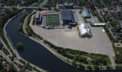
2 VISION FOR LANSDOWNE Ottawa is a beautiful, spectacular city and capital of one of the finest nations in the world. Selected as home by over a million people, the city is a safe, clean and environmentally friendly destination enjoyed by visitors and residents alike. Originally named Bytown in honour of Colonel By, architect and creator of the famous Rideau Canal, the city was eventually selected by Queen Victoria as the official capital of Canada. Uniquely located at the intersection of three impressive rivers and bridging the provinces of Ontario and Quebec, Ottawa embraces water, parkland and natural beauty. The National Capital Commission (NCC), the City of Ottawa, Parks Canada and local residents have been building and creating a city that celebrates its natural beauty and reflects its influence in our history, architecture, arts and culture. Stretching from Kingston to Ottawa, the world-renowned Rideau Canal has played a particularly important role in the evolution not just of Ottawa, but of the province and the country. Recently designated a UNESCO World Heritage site, the sights and stops along the Rideau are historic and scenic pearls that distinguish this part of the world and help define the region. Now we have an opportunity to introduce another pearl to the National Capital Region and to Canada through the transformation of Park. This opportunity is one whose time has come, and represents the City of Ottawa s commitment to its residents, to the environment, and to the vitality of the region today, and into the future. The stunning venues along the Rideau Canal, whether enjoyed by the National Arts Centre, at a tranquil lunch overlooking Dow s Lake, as a student at Carleton University, a beach volleyball player at Mooney s Bay, or as a sports and recreation enthusiast, sites along the Rideau Canal are part of what make living in, and visiting Ottawa so special. Sites along the Rideau Canal are part of what make living in, and visiting, Ottawa so special. As a community, we are obliged to recognize the decline of Park. We have a duty to transform into the pearl it should be; we have a duty to realize its potential and make it happen. This is an opportunity to bring the NCC, the City of Ottawa and citizens together to uncover the spectacular role Park can play for our mutual enjoyment and benefit. Today, is a dreary stretch of asphalt with broken-down stadium stands that are unacceptable for the nation s capital, its neighbours, cyclists, pedestrians and boaters. This 37-acre site was originally one of the points of pride of Ottawa and it deserves to be so again. Our vision for a new, vibrant and transformed is a world-class venue that will: Embrace the Rideau Canal, not hide from it; Be recreated as a green sustainable urban outdoor venue; Provide the centre stage for sports such as soccer, hockey and football; Celebrate our heritage through the re-use and re-invigoration of historic sites such as the Aberdeen Pavilion; Create an open-air front lawn for all seasons where residents, families and visitors can participate in the kind of recreational leisure and entertainment activities that make Ottawa and Canada unique; and Stand as the model of modern-day innovation in an urban form where people can go to walk, cycle, shop, enjoy a good meal, be entertained, work, live, and play. The time is now to innovate and to imagine, to encourage partnerships and growth. The time is now to realize Park s potential. 9

3 STEP 1: ANALYSIS ORGANIZING THE TEAMS The Live proposal by the Ottawa Sports & Entertainment Group (OSEG) was the impetus for the directive given by Council to staff to negotiate a partnership agreement with OSEG for the transformation of. In giving this direction, Council also required that the transformation program be responsive to specific design and development principles with the intent that staff work with OSEG to determine a redevelopment program that would address the business and financial needs of the City and OSEG. In effect, the Council direction encourages a program that would be sustainable into the future and advance Council s city building objectives as expressed in the Official Plan (OP). To respond to Council s directives, a multi-faceted work program was developed. It focused on several elements, resulting in an intensive coordinated effort by many staff, OSEG, subject experts and other key stakeholders under the direction of the City Manager and a project coordination team. To carry out the various tasks related to the redevelopment program, a project coordination team and a number of topic-specific project teams were established. The project coordination team comprised City staff, OSEG representatives, the NCC and Parks Canada. Representatives of the groups also participated on different topic-specific project teams. In addition, other key City staff from legal, real estate services and Park were also closely involved in the process. The role of the project coordination team was to compile all available existing conditions and background information to determine a sustainable development concept for the transformation program and to share this with the topic-specific teams. The following highlights the topic-specific project teams and the elements that each team addressed: GOVERNANCE & PARTNERSHIP AGREEMENTS This team was led by Kent Kirkpatrick of the City of Ottawa and Roger Greenberg of OSEG. The team was supported by members from Graham Bird & Associates (GBA), Borden Ladner Gervais, and Soloway Wright. The focus of this group s work was to develop an overall governance system for during redevelopment and the ongoing years of operations. This group has developed a partnership model for the transformation of with attention to how the whole and its individual components will work. The role of the project coordination team was to compile all available existing conditions and background information to determine a sustainable development concept for the transformation of Park. FINANCE This team included members of City staff and OSEG finance representatives, in collaboration with GBA and PricewaterhouseCoopers. This team carried out the financial analysis for the various components and integrated this information into an overall financial plan for the transformation of. CONSTRUCTION COSTING The architectural teams from Stadium Consultants International (BBB Architects) and IBI (Young & Wright), GBA and PCL Constructors Canada Inc. completed the reviews and prepared the applicable estimates for all site constructions, including: infrastructure; demolition; 10
, along with technical support from Adjeleian Allen Rubeli Ltd.")


 and OSEG representatives.")
4 relocation; retail/commerce; parking; and stadium redevelopment. STADIUM REVITALIZATION This team was responsible for developing the revitalization plans for the stadium and Civic Centre complex. Team contributors included design and programming guidance from BBB Architects/Stadium Consultants International (SCI), along with technical support from Adjeleian Allen Rubeli Ltd. (AAR) and Smith & Andersen Engineering. PCL Constructors Canada Inc. provided advice on constructability and phasing. PLANNING & DESIGN This team included City of Ottawa planning staff, OSEG representatives, the OSEG architect, plus NCC and Parks Canada representatives. This group played a key role in compiling and assessing planning and design policy and guidelines, and determining the planning and design directions for the Master Plan. This group was also involved in directing and coordinating the work of other topic-specific project teams involved in technical planning and design elements. These included transportation, transit and parking, heritage, servicing and infrastructure, as well as land use considerations related to marketing issues. TRANSPORTATION, PARKING & TRANSIT This team included City transportation and parking staff, OC Transpo and planning staff, the OSEG transportation consultant (Delcan) and OSEG representatives. This group was responsible for assessing the transportation, parking and loading circulation, and transit issues that needed to be understood and addressed as part of the overall transformation program and was instrumental in determining the proposed Transportation Strategy. INFRASTRUCTURE This team included City engineering and planning staff, Parks Canada representatives, NCC representatives, Ministry of the Environment staff, the OSEG civil engineering consultant, Delcan, and OSEG representatives. This group was responsible for assessing servicing and storm water management requirements for the redevelopment program and determining a servicing and stormwater management strategy. ENVIRONMENTAL This team included City engineering and planning staff, NCC and Parks Canada representatives, and the Delcan environmental consultant. This group was responsible for determining requirements related to the Canadian Environmental Assessment (CEA) process. HERITAGE This team included City heritage and planning staff, NCC and Parks Canada representatives, Julian Smith (an architectural heritage subject expert), representatives from the Ontario Heritage Trust (OHT) and from OSEG. A contractor was also consulted regarding the feasibility of relocating the Horticulture Building. The team identified the heritage issues that would need to be addressed, plus opportunities and options for adaptive re-use of the Aberdeen Pavilion. This team was responsible for identifying the heritage issues that would need to be addressed, opportunities and options for adaptive re-use of the Aberdeen Pavilion, options related to relocating the Horticulture Building, plus processes required to obtain required approvals and easements applying to the Park. 11

5 COMMUNICATIONS & PUBLIC PARTICIPATION PLANNING This team included City communications staff, the GBA communications team, and representatives from the project coordination team. This team is responsible for the development and implementation of comprehensive communications and public participation planning required to ensure all stakeholders are well-informed about the project and to solicit feedback on the redevelopment program, now and into the future. The team is also responsible for ensuring that both French and English-speaking audiences have access to documentation and discussions in both official languages. The work of the various topic-specific project teams was integrated and interactive with ongoing collaboration directed by the project coordination team. At all times, the redevelopment innovation by all teams was directed by Council s motion with an end result of a proposed series of directives and strategies for the transformation of. RETAIL MARKETING OPPORTUNITY STUDY This team included City planning staff, OSEG representatives and a market analyst retained by OSEG (Tate Economic Research Inc. (TER)). This team was responsible for determining the market opportunity for the retail component that will establish Park as a unique urban precinct to support and complement the Bank Street commercial sector, creating a unique experience for residents and visitors alike. TER reviewed data collection and studied the approach with the experts retained by the Glebe Business Improvement Area (BIA). The following summarizes the assumptions and findings of this report. The full report is included in the Appendices. STUDY AREA TER delineated a study area for, which is the area expected to raise the majority of the transformation s sales. This study area was further broken down into three zones: Primary Zone: Bound by the Ottawa River to the north, Rideau River to the east & south, then Bronson Avenue to the west Secondary Zone West: West of the Rideau River Secondary Zone Southeast: Beacon Hill, Hunt Club and Alta Vista subarea SCOPE OF WORK: Review of the site and its surroundings Licence plate surveys Inventory of competitive spaces On-street intercept surveys Telephone survey Retail Market Opportunity Cinema opportunity Potential impacts Study Period: Between (considering 2013 the first full year of operation) COMPETITION ANALYSIS / POPULATION LEVELS The primary zone contains 8 of the 15 Business Improvement Areas (BIAs) of Ottawa. This individuality will keep them differentiated from. The primary zone currently has a vacancy rate of 4.4% and South of the Highway 417 it is approximately 3.2%. This implies there is a shortage in retail commercial space since normal vacancy rates are between 5.0%- 7.5%. Supermarket Competition: There are currently 5 supermarkets in the primary zone, only two of which are in the Glebe BIA. There are no specialized supermarkets such as Whole Foods, suggesting a demand for s proposed 40,000 square foot specialty food store. Movie Theatre Competition: There are currently four movie theatres located in the primary zone, and two of these movie theatres have single screens. There are no multi-screen cinemas within the Study Area south of Highway 417 and only one multi-screen cinema between Highway 417 and the greenbelt. is in an excellent location for the proposed 45,000 square feet 10-screen cinema. Population Levels: The study area is forecast to experience an increase of 24,200 persons (from 526,700 in 2009 to 550,900 by 2021), which is a 4.6% increase in population over the study period. NFOR (NON-FOOD ORIENTED RETAIL)/ FOR (FOOD-ORIENTED) EXPENDITURE POTENTIAL NFOR: On average, Study Area residents currently spend $2,835.9 million per year at NFOR stores. Excluding inflation, this is expected to increase to 12

6 $3,503.6 million by 2021 from population and expenditure growth. FOR: On average, Study Area residents currently spend $1,165.1 million which will increase to $1,292.1 million by Therefore, there will be an increase of demand in the area and will not be taking away from existing retail. NFOR MARKET OPPORTUNITY ANALYSIS Examining the inclusion of 200,000 square feet of NFOR space : The proposed 200,000 square feet is forecasted to operate at $325 per square foot by 2013, which results in total sales of $65 million. Deducting 25% of total sales (to account for inflow from outside the study area) the resulting sales in the primary zone is $48.7 million in Residual for Future Primary Zone Developments: In 2013, there is a residual potential of $147.8 million for NFOR retail in the primary zone. Subtracting the $48.7 million from leaves a residual potential of $99.1 million for additional retail developments. This value increases to $188.1 million in Therefore, will not directly impact surrounding NFOR developments because it will increase the market growth in the area. SPECIALTY FOOD SHOP OPPORTUNITY ANALYSIS Examining the inclusion of 40,000 square feet of space : The proposed specialty food shop is forecasted to operate at $475 per square foot by 2013 which results in a total sales of $19 million. Deducting 10% for inflow leaves resulting sales of $17.1 million from the primary zone. Residual for Future Primary Zone Developments: (following the same steps from the NFOR market opportunity analysis) There remains a residual potential of $23.7 million for additional specialty shop developments. This value increases to $32.5 million in Therefore will increase market growth, and existing stores/ new developments will either benefit or not be impacted. STEP 2: THE PRINCIPLES OF TRANSFORMATION The key principles of the plan of transformation identified represent a City solution that has engaged OSEG through a partnership that will transform Park. Additionally, the principles not only establish the framework for the transformation program, but also the critical Partnership Plan being recommended for Council endorsement. The transformation principles are based on Council s motion. Applicable OP Policies and Guideline Directions are highlighted in the appendices, which are the basis of these principles. The key underlying broad principles determined related to planning and design are focused on: 1. The primary focus of the transformation of must be the implementation of a new front lawn. The creation of a significant public open space must be a primary driver of the plan. To become a Pearl of the capital s, the front lawn should not be a chain link and asphalt parking lot. The potential of this resource will be realized only though the partnership and the collaboration with the NCC and Parks Canada. Establishing the Queen Elizabeth Drive (QED) side of Park as an open space, green front yard that is integrated with the Canal and QED open space environment. The principle supports the establishment of a unique open space along the Canal where various activities and events can be staged such as Winterlude, the Tulip Festival, outdoor art shows, and concerts. It would also function as a venue where various activities related to community events such as opening and closing ceremonies for city-wide or national sporting competitions could be accommodated. cannot accommodate the extent of every association s desires. In programming, it must be created as the heart of a larger system. It can be centre stage for sports and other programs and it must rely on a satellite support network. The overall amount of parking must be reduced and removed, where possible, from sight. A Transit Oriented Development (TOD) and Transportation Demand Management (TDM) should be created to produce a permanent satellite and transit support system for events and major programs at Park. The history of the site should play a central role. The Aberdeen Pavilion must serve as a focal element in and a highlight of the front lawn open space. Its use for food services including restaurants, bistros or cafés should be year-round and accessible to all. 13


7 5. The stadium revitalization, the centre court for sports, is a key element of the transformation. The new stadium should be integrated into its surroundings and enhance the functionality to permit at least football, soccer and hockey. The architecture of the facility should be inspiring, innovative and consistent with the overall vision for It should enhance its surroundings and provide for significant gateways from Bank Street to the Canal. Create a governance model for that will ensure the sustainability of and the Partnership; one that will focus initially on the implementation and secondly on the ongoing operations and programming of Park. Create an overall mix of uses which can provide a basis for the Partnership that is financially sustainable. The transformation must have a solid basis to ensure that the pearl can be enhanced over time. Embed LEED certified infrastructure and lifecycle maintenance into the plan and avoid the kind of decay seen today. Step 3: Detailed Principles Street while maintaining optimal areas for pedestrians attending major events at the stadium and the Civic Centre. The objective is also to develop a unique front yard experience for the stadium and Civic Centre complex along Bank Street. Physically and functionally integrate parkland with the QED/Canal open space corridor and experience. Concentrate new development along the Bank Street edge and between the Civic Centre and Holmwood Ave. Ensure commercial uses to support strong pedestrian animation within the commercial sector and for Park with continuous at grade retail, service, and restaurant uses along all pedestrian routes. Provide for new development to be predominately low profile and human in scale, with some potential for higher profile development adjacent to Bank Street. Provide active commercial uses along the north side of the Civic Centre to establish an animated internal commercial street, with the Aberdeen Pavilion functioning as the Park s focal point. Enclose and animate the south side of the south side stadium stands to better integrate and relate to the QED experience. Locate commercial servicing and back-ofhouse operations for the stadium where these will not have an impact on the unique open space and pedestrian-focused commercial environment to be established for Park. 6. The new development should offer a mix of uses that exemplify the goals of a healthy and sustainable community, respecting important sightlines and architectural design guidelines. Concentrating new development within the northwest sector of the site and having this area established as a unique urban area and pedestrian priority zone with uses that will establish Park as an innovative, functional and modern venue complementing sports and entertainment activities, the Farmers Market, the Rideau Canal and the Bank Street commercial corridor. Planning & Design With the principles noted above in place, the following was determined: Establish the QED side of Park as the front yard. Develop the front yard as a unique city and capital asset that is a public focal point along the QED and Canal and integrates with the QED/Canal open space corridor to contribute to the overall QED/Canal experience for residents and visitors. Integrate an innovative water/pond feature into the green space that may also serve as a stormwater facility. While some active community recreation facilities may be accommodated, the focus of the green space development is to be on unique features that support seasonal outdoor activities and uses, e.g., an area for staging of Winterlude activities, outdoor concerts in a band shell, outdoor art shows, etc. Advance OP design objectives for development along the Traditional Mainstreets and for creating pedestrian focused environments. Achieve this by establishing unique retail development along Bank 14

, defining how the City over time will advance/achieve")
8 Integrate on-site vehicle circulation with the pedestrian environment ensuring that the pedestrian environment has prominence. Locate residential uses along Holmwood Ave. to integrate with the Glebe community. The provision of some limited residential development to provide for integration and mixed use is consistent with policies set out in the OP. Examine potential for accommodating residential space on the second storey of new commercial development along Bank Street consistent with the OP directions for Traditional Mainstreets. TRANSPORTATION, PARKING & TRANSIT The transportation, transit and parking principles draw from directions in the Transportation Master Plan (TMP), defining how the City over time will advance/achieve a sustainable transportation system to serve the city s access and mobility needs. The following TMP directions are of particular relevance to Park and underpin the transportation, parking and transit principles: Leading by example by:» Minimizing energy use and environmental impacts of City transportation facilities, fleets, operations and services;» Fostering walking, cycling and transit use by employees and visitors to City facilities; and» Forging constructive partnerships with the private sector, institutions and community organizations. Creating supportive land uses by:» Encouraging compact mixed use development at strategic locations (Traditional Mainstreets are identified as one such location).» Reviewing development proposals to ensure that: Sidewalks are provided with pedestrian and cycle links to public areas clearly defined; TDM strategies can be supported with the provision of bike parking, carpool parking, etc.; and Traffic assessments address pedestrian, cycling and transit requirements in addition to roads and parking.» Encouraging compact development by reducing land area used for parking by capitalizing on opportunities for shared parking and opportunities for partnerships with the private sector to provide parking structures. In the context of the guiding directions of the TMP, the redevelopment of provides an opportunity for the City to demonstrate leadership in advancing a sustainable transportation strategy. This will ensure that Park will be an accessible, dynamic urban venue that maximizes its strategic location with use of existing and enhanced transportation systems to reduce on-site parking and return to the community as a viable facility and true asset. The full Transportation Strategy Report is attached in the Appendices. The following highlights the key determinations made related to transportation, parking and transit: Maximize development of below-grade parking where new development is to be located. Amount of parking provided to be minimized, but to be sufficient to address day-to-day needs of commercial uses and daily activities at. The permanent on-site parking supply target is approximately 1,600 spaces supported by a transportation strategy to manage peak demands. Any use of hard surface area provided for staging front yard activities and events for parking to be limited. Maximum parking that may be accommodated in the front yard will be approximately 380 spaces with the objective to minimize usage. Front yard parking will be esthetically integrated into the landscape plan so the areas are not obviously seen as parking areas, but rather as activity areas for staging of various events. Provision of off-site satellite parking to support major events to be part of overall transportation strategy. Transportation strategy to be focused on means to maximize alternative travel modes for major events specialized transit to support major events, strengthened links to pedestrian and cycle routes, provision of satellite parking with shuttle service for major events, enhanced use of QED to accommodate event transit service, etc. Transportation strategy for major events to identify needs for offsite parking, shuttle and transit operational needs for different event thresholds to allow resources to be mobilized in accordance with a predetermined framework. 15


9 ENVIRONMENT, STORMWATER MANAGEMENT & INFRASTRUCTURE No issues or concerns were identified with accommodating the transformation program related to water, sanitary or other utilities. These matters would be addressed through the normal course of development approvals. There was, however, a need to develop a stormwater management strategy that was acceptable to the NCC, Parks Canada and the Ministry of the Environment (MOE) because part of the site currently drains into the Canal and the combined O Connor Street sewer cannot receive any additional storm flows. The infrastructure and environmental engineers of Delcan and DSEL met with City officials and representative from Parks Canada and the MOE to discuss stormwater requirements for the proposed transformation of. This collaboration led to the creation of an effective stormwater strategy that features green stormwater management solutions, including semipermeable parking and, where possible, green roofs. The strategy also set out parameters for allowable release rates and the provision of separated sewers for storm and wastewater. A sustainable LEED solution that aesthetically enhances will be the answer. (Full details of the strategy are found in the Appendix: Preliminary Due Diligence Report: Re-development Plan). Collaboration led to the creation of an effective stormwater strategy that features green stormwater management solutions. The project will require federal approvals from the NCC and Parks Canada, as a result of the need to retain the current storm outlets to the Canal. These approvals will likely trigger the requirements for an Environmental Screening Report in accordance with the Canadian Environmental Assessment Act (CEAA). Discussions with the key federal stakeholders are underway to determine the required scope of the Screening Report. HERITAGE The heritage elements that need to be addressed as part of the transformation program include the Aberdeen Pavilion which is designated under the Ontario Heritage Association (OHA) and a federal heritage resource. Another consideration is the heritage easements established by the Ontario Heritage Trust (OHT) protecting sightlines for the Aberdeen Pavilion and the Horticulture Building, also designated under the OHA. Also, the Aberdeen Pavilion is subject to a cost sharing agreement with Parks Canada. Any changes to the heritage resources alteration, adaptive re-use, demolition, relocation and modifications to easements require approvals under the OHA and/or through the OHT and that Parks Canada be consulted. The key principle is to have the Aberdeen Pavilion as the focal element of a transformed Park. Associated principles flowing from this are as follows: Retaining the Aberdeen Pavilion in its present location and established as focal element of in form and function accommodating a unique year-round use. The proposed concept is to create a unique experience within the building with small internal pavilion outlets that allow for inside pedestrian streets animated with cafes, unique shops, services, etc. Relocating the Horticulture Building where it will maintain its relationship with the Aberdeen Pavilion but allow for potential use as part of the Farmers Market for indoor market stalls or craft boutiques. (Council direction was to retain the façade of this building only.) Views to Aberdeen to be protected and new views to be established to ensure it is the focal element of ; in order to achieve this, the potential exists to modify the easement as it relates to sightlines and the view corridors, which will require OHT approval. UNIQUE MARKETING The full retail market study report is attached in the Appendices. The key determinations in this study report are highlighted below: Utilize the market study to assist in determining the nature of commercial uses to be provided. The guiding principle is that the retail experience 16


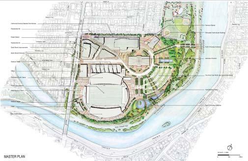
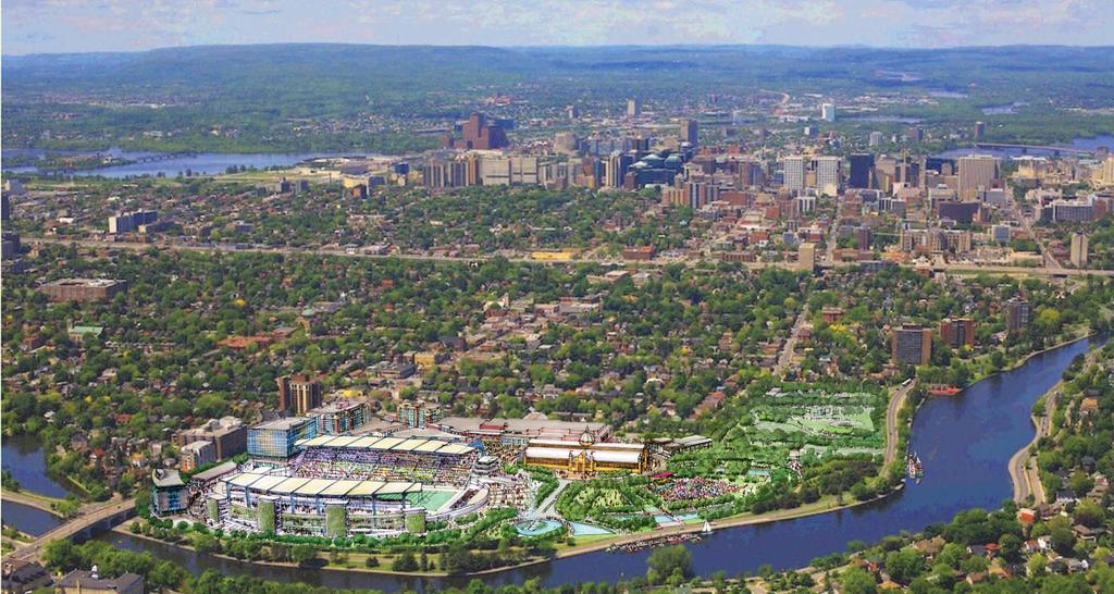
10 will be unique and complementary to the Bank Street commercial enterprises. Provide uses that will focus on positioning commercial uses as part of the Bank Street business area supporting both local commercial needs and the broader market. Aim for the uses at to complement and support the economic vitality of the existing Bank Street commercial corridor and the entertainment and recreational focus of Park to establish a revitalized community area around Bank Street. Nature of uses to focus on food (restaurants, specialty food stores), entertainment (sports bars, theatre), lifestyle (fitness centre, athletics shops), unique and specialty retailing (sporting memorabilia, crafts, etc). Ensure the nature and intensity of commercial use will be sufficient to address OSEG revenue needs to support the stadium and Civic Centre operations for the term of their lease. This requires that the commercial enterprise be sustainable with flexibility for change but continuing to function within an overall strategy to ensure proper fit and market objectives. No large-scale box stores will be considered. The solution shall enhance the viability of existing Bank Street commercial enterprises. Provide for the active year-round use within the Aberdeen Pavilion to support it as a focal element for both the community and Park. Provide for Aberdeen to be part of the long-term lease with OSEG to allow for commercial planning. Commercial needs to be special, unique and appropriate for their location within an architectural landmark heritage building. Provide for the active year-round use within the Aberdeen Pavilion to support it as a focal element for both the community and Park. Ensure the current Farmers Market is included as part of the mix of commercial uses strategically located to reflect this historical vocation of Park. Consideration has also been given to keep the Market focused on the Aberdeen Pavilion and possibly use a re-located Horticulture Building for a use that is integrated with the Farmer s Market. Discontinue use of the Park for trade shows. Relocate this activity to other more suitable sites/venues. There may remain some potential to accommodate smaller consumer show space within the Civic Centre/Stadium complex. Larger trade and consumer shows must be accommodated in appropriate venues in Ottawa where the unique demands of the shows can be readily met related to parking and limited timelines. These demands cannot be accommodated through the redevelopment. STEP 4: THE MASTER PLAN & ITS COMPONENTS The key directions set out in the Transformation Plan section established the basis for developing a Master Plan for the transformation of Park. The key elements of this Plan are highlighted below: THE NEW LANSDOWNE EXPERIENCE The transformed will be the ultimate destination. From unique boutiques and restaurants to the UNESCO World Heritage experience of the Rideau Canal, live entertainment in the Park and the adjacent Farmers Market, residents and visitors alike will enjoy an experience at the new like no other in Ottawa. The collection of retail, entertainment and dining destinations will transform a family outing into an engaging, interactive experience. will be Ottawa s finest mixed-use centre with intriguing retail stores and services in an open-air setting surrounded by the Rideau Canal. Integral to the mixed-use approach, the plan has incorporated residential, hotel and office uses into the new Master Plan. The rejuvenated Frank Clair Stadium and Civic Centre will provide a unique sports experience serving fans of professional football, hockey and soccer. Historic treasures such as the Aberdeen Pavilion and the Horticulture Building will be incorporated into the mix as key destinations. The Aberdeen Pavilion and the surrounding under-utilized paved parking lot will be redeveloped to create a legacy of improvements for the City, as an asset to the surrounding neighborhoods, and create a new mixed use and shopping area that will reinforce, reinvigorate and complement the strong urban fabric that exists on Bank Street and in the Glebe. Over 40 per cent of the site will feature new green parkland and open space as part of the renewed Park. The Aberdeen Pavilion will be situated as the focal point of a new public piazza showcasing this important landmark. Four new view corridors from the Bank Street and Holmwood intersection, Bank Street, Adelaide Street, as well as the Queen Elizabeth Drive and Rideau Canal will be created to highlight the Pavilion. Density and building masses for new retail buildings are one and twostorey in scale with the Pavilion and other surrounding neighbourhood buildings. 17

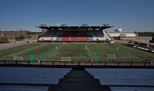
11 The vision of Park includes all aspects of a viable and sustainable urban neighborhood: a unique mix of small and medium retail shops and restaurants, a cinema, specialty food outlets, residential apartments and office space surrounding the re-invigorated Aberdeen Pavilion. Pedestrian and visual links will be created among the Glebe, the Pavilion, and the Rideau Canal. Residents and visitors will be able to take a leisurely stroll down pedestrian avenues making stops along the way at specialty boutiques and outdoor cafes, enjoy the fun and excitement of going to a movie or celebrate a special occasion by dining in the beautiful and historic Aberdeen Pavilion. In keeping with truly sustainable community principles, will also serve the needs of the local residential population in the form of boutique food and wine stores, fitness/wellness/health centres, and clothing stores. The mix of stores will provide the perfect atmosphere to complement the existing commercial area along Bank Street while making it a preferred destination along the Rideau Canal. Four-season programming and activities will ensure that is a year-round asset adding vibrancy and excitement to the neighbourhood, the city and the region. The redevelopment project incorporates and highlights principles of sustainable development and LEED building standards, including the reduction of hard surface area, creation of new public green space, energyefficient building design, renewable building material use, pedestrian improvements, and provisions for improved integration with public transit. The strengths of the retail plan and benefits to the City and neighborhoods include: Reinforcement of Bank Street via a prominent built form along the street front with active retail uses. A new public plaza at Bank Street and Holmwood that provides a gateway pedestrian route to the Aberdeen piazza and the Park beyond, as well as an important new view line to the Aberdeen from the intersection. A new boulevard from Bank Street to the Aberdeen Pavilion with unobstructed views. The boulevard will be the principal vehicular and pedestrian link between Bank Street and the new development and parkland, as well as provide a new link to the Queen Elizabeth Driveway. A piazza surrounding the Aberdeen Pavilion allowing a wide variety of public uses. A new view line to the Pavilion at the terminus of Adelaide Street and a pedestrian link from the Glebe to the shops, Aberdeen and new parkland. An enhanced view of the Aberdeen from the Queen Elizabeth Drive and Rideau Canal across the new parkland. Improved streetscape on Bank Street with widened sidewalks, street trees and lighting. A series of smaller retail blocks conducive to the types of medium- and small-sized shops, restaurants and entertainment that the urban dweller has come to expect on Bank Street. New pedestrian-friendly streets linking Bank Street to the Aberdeen and the new park. New underground parking facilities reducing vehicular/pedestrian conflicts. Continuous active storefront streetscapes on Bank Street and the new streets; streetscapes shall be designed to incorporate areas for sidewalk cafes and other outdoor activities. is an integral part of the community and its new urban village is an open-air concept featuring one-of-a-kind experiences that will delight residents and visitors for years to come. Over 40 per cent of the site will feature new green parkland and open space as part of the renewed Park. OPEN SPACE THE FRONT YARD The existing east and south portions of the site consist of broken asphalt paving. The proposed design will convert this land to parklands, including a beautifully landscaped stormwater management pond. It will blend seamlessly with the adjacent NCC land and offer the opportunity for connections to day-moorings in the Canal. Seasonal events will be programmed throughout the site including Winterlude activities which can be coordinated with access to skating on the Canal, Tulip Festival combined with related uses in the Horticulture Building, art and music festivals, wine and cheese festival featuring Canadian products, sporting events, and a multitude of additional activities. STADIUM/ARENA DESIGN The location of the Frank Clair Stadium and Ottawa Civic Centre immediately north of the Bank Street Bridge and north and west of the Canal has afforded both users of the Stadium and passersby with a dramatic vista. 18


12 The sheer size of the grandstands is awe-inspiring when viewed from the Canal, NCC lands and the Bank Street Bridge. This central location is ideal for visitors from all parts of the city due to its easy accessibility. In order to provide a first class home for the Ottawa 67s, Ottawa s new CFL team and future professional soceer team, innovative design will transform the sports centre. The proposed new south grandstand and carefully planned new facilities at the base, along with re-roofing and refurbishment of the north grandstand, will provide state-of-the-art athletic and broadcast accommodations as well as related new retail and dining amenities. Proposed materials incorporate buff coloured masonry for the base and new white roofs for both new and existing construction. The major functional program spaces for the stadium, including home and visiting team dressing rooms for professional and university-level teams and community use; Food and beverage storage and preparation facilities; Facility loading and operations; Media facilities, including a new press box; Team offices; Enclosed storage space; and New private suites and a climate-controlled VIP Club. With wider seating to be installed at the north grandstand, the total seating capacity of the stadium will be 24,000. the building by providing a façade along the sidewalk s edge. The Civic Centre will benefit with increased visibility and more inviting entrances along the building s north face. Upgrades to the existing facilities include giving the interior spaces of both the Civic Centre and Frank Clair Stadium a complete facelift with new floor and ceiling finishes throughout the public areas (including the suite area), as well as new paint, new washroom wall tiles and fixtures, and improved concession stands. As well, the stadium s north grandstand will be refurbished, including: replacement of all seats with minimum 19 -wide seats, re-sealing of joints To provide a first class home for the Ottawa 67s, Ottawa s new CFL team and future professional soceer team, innovative design will transform the sports centre. A primary element of the stadium design is a new south grandstand, which will provide 10,000 seats with supporting washroom and concession areas, as well as: The design of the new structures forming the stadium perimeter will: Be integrated with the site layout, creating an enhanced pedestrian zone around the entire stadium; Effectively mix hard and softscaped areas to integrate texture and colour with the transformation elements to the north and east of the stadium; and Include wider sidewalks along Bank Street and pedestrian walkways through the new retail zone creating an inviting path for spectators and patrons and building excitement en route to a sporting event, concert or other live programming. The architecture of the north grandstand and Civic Centre arena will be improved with new retail space at the north and west facades, enhancing the connection of the stadium and area to the new streetscape around at precast seating tiers; and replacement of concourse slabs and waterproof membranes to remedy leaks in the existing building envelope. To further enhance the spectator experience, the existing south (lower) concourse of the Civic Centre will be updated as a new Club Concourse, with higher-end finishes and more customer service points for Club-seat patrons. 19

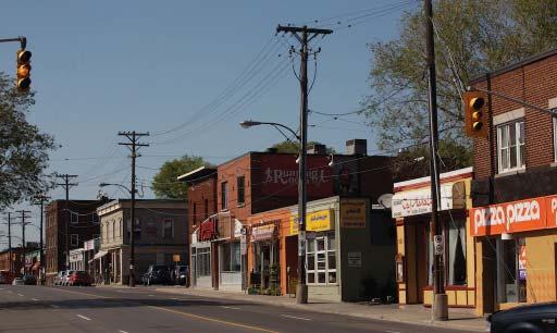
13 This area will serve dual purpose as a club space for both indoor arena events and outdoor stadium events. Suite holders in the Civic Centre will also benefit from improved suite access with a new elevator and stair system, providing more direct and convenient access from the main concourse. Structural modifications (i.e., post-tensioning of the main arch structure) will be done to ensure that the existing structure continues to function as originally intended. As well, the mechanical and electrical systems will be upgraded as follows: HVAC system in the Civic Centre arena seating bowl and concourses to provide year-round comfort, as well as dehumidification above the ice to prevent fog above the ice in spring and fall; New low-flow plumbing fixtures throughout the building to meet current Building Code and reduce water usage; and New electrical distribution and energy-efficient lighting throughout the arena and stadium, including new event lighting for the stadium. The outdoor playing field surface will be replaced with the latest stateof-the-art artificial turf system, allowing for multiple uses throughout the year, including use with an air-supported structure through the winter months. The location of the field will be changed as well, to allow better sightlines to the field for all sporting events. Finally, a new sound system and cutting-edge scoreboard will be installed at the west end of the stadium, providing the latest in video board technology. The refurbishment of Frank Clair Stadium will provide the potential for bringing a major league football team back to Ottawa in addition to a new venue for international soccer matches. International skating competitions as well as public skating will continue in the Civic Centre, along with indoor concerts and other special events. NEW DEVELOPMENT New development will be focused in the northeast sector of the Park to create a unique pedestrian focused mixed-use precinct complementing the heritage of and its sporting and entertainment vocation. Bank Street is a major street in the city of Ottawa leading into the city from the regions to the south and terminating at Parliament Hill to the north, thus connecting many parts of the city to Park and the Glebe. It is the principal access point to Park. The adjacent Bank Street Bridge over the Rideau Canal is one of the most architecturally outstanding bridges in the City. The Bank Street location of Park is one of its greatest assets. Trees will line the boulevard along Bank Street, as will light standards matching those of the Bank Street Bridge. These features combined with attractive varied paving materials are proposed for the sidewalk from building face to the curb providing a contemporary urban experience with nostalgic overtones for visitors approaching the site from any direction. The northeast sector of the site will be developed to extend the pedestrian realm of Bank Street into the site along retail-lined streets that will be pedestrian priority areas. These areas will lead to the Aberdeen Pavilion and defined pedestrian lines through the open front yard to the Canal and the QED recreational path system. The proposed design is planned to provide a traditional urban ambiance punctuated by landmarks and special event locations. Internal streets within the new retail area will provide vistas of the Aberdeen Pavilion from the principal entrance off Bank Street, the corner of Bank St. and Holmwood Avenue, the Queen Elizabeth Driveway, and the intersection of Holmwood Avenue and Adelaide Street. Additional internal streets within the northwest retail precinct will break the retail buildings into small clusters which increase the street frontage and variety of shopping and dining experience. Along Bank Street, the pedestrian experiences a continuation of the small shops north of punctuated by the main entrance to the site and, closer to the Bank Street Bridge, a second entrance serving primarily the Stadium uses and the proposed hotel. Within the site, there is easy pedestrian circulation throughout leading to all of the various buildings and activities. The visitor or resident can move from busy retail to athletic activities, or a casual stroll through onsite parkland or farther out to the NCC park system and the Rideau Canal. COMMERCE/RETAIL The proposed design will continue the tradition of two-storey, small retail shops along Bank Street in the Glebe. The northwest portion of the site is organized around a village type streetscape with a mixed pedestrian/ vehicular zone. Designed as a series of mid-sized, irregularly shaped blocks, the façades will be carefully articulated and designed to read as individual small buildings. 20

14 New buildings along Bank Street will be constructed as part of the new commercial development. These buildings will utilize articulated brick with high quality glazed entries and windows and include stone cornices, column/pier caps and sills. Awnings in a variety of colours and configurations are proposed above the storefront glazing between brick/ stone piers. The presentation to the street will continue the tradition of two-storey façades along Bank Street. Above the second storey, residential and office uses will be set back from the street façade, but will also be constructed of the same brick and glass as the street level. The proposed new two-storey retail/office building will be clad materials such as stone and elegant frameless glazing. The lighter colours and clean lines are intended to provide a transition between the Bank Street character buildings and the sparkling, light colours of the Pavilion. The overall intent is to have a healthy, vibrant retail sector in active pedestrian zones. The building shapes and orientation will create friendly exterior spaces in relation to one another and to the Aberdeen Pavilion and Horticulture Building. New underground parking for up to 1,110 vehicles is proposed below the new northwest development. This two-storey retail component will continue southward along Bank Street maintaining a continuous street edge to the approach to the Bank Street Bridge and, by this connection, to Ottawa south of the bridge. A high-end food store is proposed within the retail buildings which will complement the Farmers Market and the existing local food retailers to provide an extended range of grocery options for both neighbourhood residents and visitors from other parts of the city. Shops and restaurants in the retail portions of the site will bring lively activity to throughout the day and evening. Also within the retail buildings, a multi-screen cinema is proposed which will provide additional evening visitors to the site. The Farmers Market will be located toward the northeast of the Aberdeen Pavilion with the relocated Horticulture Building immediately to the east of it. Finally, a new underground parking facility for up to 1,100 vehicles is proposed below the new northwest development. OFFICE BUILDING Along Bank Street a six storey office building will be incorporated above the two-storey retail south of the main entrance to Park. Office uses will also be located in second floor locations within the retail sector. These offices will contribute to the daytime activity on the site. BOUTIQUE HOTEL A hotel is proposed in the southwest area of the site. This will provide a base for visitors to the Ottawa region who will avail themselves of the amenities at while also providing the site with a cosmopolitan flavour. The proposed hotel, located in the southwest corner of the site adjacent to the Bank Street Bridge and the proposed new south grandstand, will consist of an eight-storey, 180-guest-room tower which will be at approximately the same height as the proposed new south grandstand. To complement the more modern character of this athletic complex, the hotel will be a sleek glazed arc-shaped building offering extraordinary views of the Rideau Canal and the Bank Street Bridge to the east and south, the Stadium and the Aberdeen Pavilion and parkland to the northeast, Dow s Lake to the northwest, and a vista of downtown Ottawa to the north. The glazing will incorporate state-of-the-art insulating features to comply with energy conservation criteria. Parking for the hotel will be provided in structured parking below the hotel. Underground loading will also be incorporated into the building. RESIDENTIAL To further the continuous use of the site, new residential uses are proposed consisting of a four-storey condominium component above the twostorey retail on the north portion of the site, and a six-storey residential component above the two-storey retail on the northerly portion along Bank Street. This development is north of the main entrance and it will complement the six storey office to the south, creating a gateway into from Bank Street. Finally, 20 stacked townhomes (40 units) along the south side of Holmwood Avenue are proposed and will provide a close integration of the new development with the existing houses on the north side of the street. 21

15 HERITAGE The historically-designated Aberdeen Pavilion is currently under-utilized due to heating limitations. The proposed design will make this building the centerpiece of the redevelopment. Views from all directions will focus on the Pavilion. Within the Pavilion, small, glass-enclosed climatecontrolled structures are proposed to allow for year-round uses such as restaurants, a gift shop and other hospitality uses. Mezzanine spaces open to the expansive structure will provide festival centre support spaces, meeting areas and assembly spaces suitable for informal live venue performances. These small, transparent structures would allow for views of the existing Pavilion volume and structure. The historically-designated Horticulture Building has not been maintained and is currently boarded-up due to peeling lead-based paint. The proposed design will include relocating it into the front yard to the east and re-purposing it as part of the Farmers Market activities as well as programming for arts, culture, education and children s programs. SUSTAINABLE DESIGN The transformation of Park offers a unique opportunity to embrace sustainable design principles and achieve LEED Certification, one of the key goals of the project development. Given the comprehensive redevelopment of the site with its wide variation in the building types and proposed uses, LEED Neighborhood Development (ND) offers the most appropriate method for achieving LEED certification. Key elements in support of LEED ND Certification for are: Centrally located urban site with the benefits of the existing adjacent community; Development on previously developed lands; Good existing transportation and increased use of public transit; Adjacent to bicycle network strong connection and integration; Redevelopment of a brownfield site to include major green spaces; Opportunity for stormwater conservation through the use of a proposed storm water management pond and on-street innovative urban swales; Proximity of housing to jobs; Access to civic and public spaces; Access to recreation facilities; Access to food produced locally; Re-use of existing buildings; Historic building preservation and adaptive use; Reduction of parking footprint through the provision of underground parking; Use of existing off-site parking facilities for major events; and Heat island reduction by replacing existing asphalt with vegetation. The above are examples of criteria which are met and incorporated in this approach. Many additional opportunities will be pursued as the details of the design are developed. The project includes walkable streets, pedestrian precincts and zones, compact development which is both connected and open to the wider community, in addition to comprehensive sustainable site development. Adopting a LEED Design approach will establish clear guidelines for building design. The new buildings will be designed to LEED Silver standards consistent with the individual building types; e.g., retail, office, residential. Adopting a LEED Design approach will establish clear guidelines for building design that addresses: Sustainable site design; Energy efficiency measures; Water conservation and quality; Conservation of materials and resources in the make-up of building construction; Indoor environmental quality; Alternative transportation from fuel-dependent vehicles; Reduction of heat island effect and light pollution in built-up areas; plus Conservation and adaptive re-use of existing buildings. The LEED Certification process requires documentation and quantification with independent verification to demonstrate how each LEED credit has been achieved in order for the project to receive LEED Certification. The site offers a very special opportunity to celebrate and educate residents, users, and visitors on the Earth s most precious resource Water. 22

16 The accessibility to the Rideau Canal system with its connections to Brown s Inlet and Dow s Lake will be supplemented by the addition of a storm water management pond and bioswales which will provide aesthetic enjoyment while enhancing water quality on site. The opportunity to incorporate water features, sculptural fountains and interpretive nature paths through the east and south portion of the site will be explored. Where appropriate, roofs will be designed to meet the LEED Silver requirements. These measures will dramatically reduce the volume of stormwater runoff from the site while enhancing the quality of the residual runoff into the City system. The opportunity to incorporate water features, sculptural fountains and interpretive nature paths through the east and south portion of the site will be explored. TRANSPORTATION STRATEGY Based on the transportation study and analysis, a Transportation Strategy has been developed to support the redevelopment program based on Council s motion. This strategy provides for transportation needs to be strategically addressed to support the range of venues and activities that will be accommodated in the transformed Park. The strategy is broken down below into four components: Site Development, Off-Site Needs, Operational Requirements, and Transit Service. SITE DEVELOPMENT COMPONENT Provision of approximately 1,100 below-grade and 135 at-grade parking spaces to support the day-to-day activities associated with development of Park. The provision of parking for the proposed residential and hotel components to be generally self-contained and to be in addition to the shared parking space total. Development of activity staging areas in the planned front yard (between Aberdeen Pavilion and QED) that can also serve as additional parking (approximately 380 spaces) for larger Civic Centre/Stadium events, but only if these areas are not required for other programming activities/events. Maintaining four vehicular access points, two from Bank Street and two from the Queen Elizabeth Drive and locating access to the below-grade parking to minimize interference with pedestrian movement and to reinforce the focus of Park as a pedestrian area. Provide a four-lane driveway width with light signals at the site s connection to Bank Street to provide sufficient capacity to efficiently accommodate traffic entering and exiting the proposed below-grade parking garage. Design below-grade parking access/egress points to be three lanes (reversible) to accommodate the peak demands of getting cars in and out during major events. Provide visible and direct vehicular access/egress to/from Bank Street for the proposed hotel, as hotel patrons may not be familiar with Ottawa or the site. Provide a centralized loading area for the commerce and define an onsite loading route that provides access/egress from Bank Street that minimizes interference with pedestrian areas and regular vehicle access needs. Locate loading for the Stadium/Civic Centre in a location where it will not interfere with pedestrian movement and define an on-site truck route that provides efficient access/egress to/from Bank Street. Provide well defined pedestrian/cycle connections and links to off-site pedestrian/cycle facilities. Provide sufficient pedestrian gathering areas along the Bank Street frontage to safely accommodate pedestrian volumes for large events as they enter/leave the site, wait to cross Bank Street and wait for transit. Provide secure bike parking to meet by-law requirements and locate these where they are easily accessible. Build into the site development program physical Transportation Demand Management (TDM) measures and other supporting uses (such as bicycle rental or VRTUCAR). Provide an on-site location for shuttle drop off and pick up to bring people from and to off-site satellite parking lots. As enhanced Route 1 and 7 bus service will be operating on Bank Street, the additional shuttle buses would operate on QED, thereby requiring the on-site transit stop to be close to the site s eastern QED frontage. 23
17 OFF-SITE NEEDS COMPONENT Implement the Bank Street Rehabilitation to coincide with the Park redevelopment and ensure that the design for Bank Street supports the access, transit and pedestrian needs of the development program. Secure off-site parking through arrangements with owners of identified lands to enable the provision of efficient, high quality shuttle bus service. This is required to reduce on-site and adjacent community parking pressures during higher attended events at the Stadium. Identify and secure off-site areas for staging larger vehicles (trucks) associated with supporting major events at either the Civic Centre or Stadium. Finalize, through the Collaboration Agreement with the NCC, limited use of the QED by commercial and/or transit vehicles to support periodic major events at the Stadium. Finalize an agreement with OC Transpo to provide transit shuttle service for major Stadium events to/from satellite parking lots and to/from rapid transit facilities, as appropriate. Provide for boat docking facilities on the Rideau Canal at the key wateraccess point to Park from Queen Elizabeth Drive. OPERATIONAL REQUIREMENTS COMPONENT Management of on-site day-to-day circulation activities including: uninterrupted access to the parking garage, control of service and goods delivery in off-peak periods and not at night when it could impact on the hotel and residential land uses. Managing on-site parking including: priority spots for office use car poolers, requirement for pre-paid passes for major Civic Centre/Stadium events, implementing reversible lanes at garage access/egress points for larger events so as to efficiently process entering/exiting vehicles, and directing exiting traffic to Queen Elizabeth Drive following large events to minimize impacts on pedestrians and on Bank Street transit service. For mid-size to major events, varying levels of traffic control will be required including possible signal timing adjustments, police control of Bank Street pedestrian crossings, police control of access/egress to Queen Elizabeth Drive, on-street parking prohibition for two hours before and after large events, road closures (Bank Street and Queen Elizabeth Drive), and police escorts for transit vehicle after major events when adjacent streets are closed to vehicles, but are being used by pedestrians. TRANSIT SERVICE COMPONENT With the rehabilitation of Bank Street, improve transit service by: incorporating the proposed northbound lay-by-lane, relocating the adjacent bus stops to the north of the site s driveway intersection where there is a stop light, widening adjacent sidewalks and providing sufficient pedestrian storage areas on both sides of Bank Street. Maintain the basic Routes 1 and 7 service, and increase frequency as required to respond to day-to-day needs. For mid-size events (4,000 to 10,000 person capacity) add two to four additional buses on Bank Street (see the Transit Service Strategy map on page 25). For mid-size events (10,000 to 15,000 person capacity), add additional Bank Street buses (two to four) and enforce existing parking/stopping restrictions along Bank Street, as per the Transit Service Strategy map. For larger events (15,000 to 25,000 person capacity) add extra Bank Street buses and ban parking in both directions for a period of two hours before and two hours after the event, as per the Transit Service Strategy map. For larger events (25,000 to 35,000 person capacity) add extra Bank Street buses and convert the curb lanes on Bank Street to bus-only lanes for a period of two hours before and two hours after the event, as per the Transit Service Strategy map. The extra Bank Street buses will comprise additional Route 1 or 7 buses, special buses running from Billings Bridge Station to downtown, and shuttle buses serving the off-site parking lots. For the infrequent large scale events (35,000 to 45,000 person capacity), add extra Bank Street buses and close Bank Street to traffic, except for buses, from Sunnyside Avenue north to Fifth Avenue for a period of two hours before and two hours after the event, as per the Transit Service Strategy map. The extra Bank Street buses will comprise additional Route 1 or 7 buses, special buses running from Billings Bridge Station to downtown, and shuttle buses serving the off-site parking lots. For the very infrequent largest scale events (45,000+ person capacity), add extra Bank Street buses and close both Bank Street and Colonel By Drive to all traffic except buses for a period of two hours before and two hours after the event, as per the Transit Service Strategy map. The extra Bank Street buses will comprise Route 1 or 7 buses, special buses running from Billings Bridge Station to downtown, and shuttle buses serving the off-site parking lots. The closure of Queen Elizabeth Drive is necessary to accommodate high frequency (every 30 to 60 seconds) shuttle bus service between the downtown transit way station and Park, and between other south and west remote parking lots and/or rapid transit stops and. TRANSPORTATION ACTION PLAN Based on the above analysis: site-generated traffic for the range of proposed on-site activities; the range of transit model delegation likely achievable for these activities, the on-site and off-site parking supply and demand; and the layout and operation of the proposed site plan, the Transportation Strategy sets out an Action Plan for the transformation. These actions provide a road map to implement the Transportation Strategy and the activities and events at a transformed Park. 24


18 TRANSIT SERVICE STRATEGY MAP 25
19 STEP 5: PLAN IMPLEMENTATION Achieving the vision for requires a continued concerted effort by many. This multifaceted effort is focused on having the Partnership Plan finalized and approved, continued involvement of stakeholders, and obtaining formal approvals. The plan shall be carried out in 2 phases. Phase 1 includes the front lawn, parking, retail and stadium/ arena. Phase 2 includes the hotel, office and residential components. The following highlights the key elements of the additional work to realize the transformation of : PUBLIC CONSULTATION The April 22 motion from Council directed that the process for transforming include comprehensive public consultation prior to Council rendering a final decision on the Partnership Plan. The Public Participation Plan detailed in this Report outlines the consultation approach to inform and engage the public. A key element of the public consultation is to obtain input regarding refinement of the design for the front yard by the Canal. PARTNERSHIP AGREEMENT Included in this Partnership Plan is an MOU between the City and OSEG. This MOU is the foundation for developing a formal partnership agreement for approval by Council and will establish the roles and responsibilities of the City and OSEG. The partnership agreement will lay the groundwork for the municipal corporation to be set up as the governing body for the transformation and its ongoing operations. MUNICIPAL CORPORATION The premise of the partnership agreement is the establishment of a municipal corporation set up under the Municipal Act as the governance body to oversee the physical transformation of and the ongoing operations of the new Park. FINAL COUNCIL APPROVALS Final approval by Council of the Partnership Plan, the partnership agreement and the establishment of the municipal corporation is required to begin moving forward with the s transformation. With Council approval, the stage will be set for initiating the required planning approvals, securing the necessary financing, finalizing other stakeholder agreements, and beginning the physical transformation of the site. PLANNING APPROVALS Council s Motion directed the City to ensure that the transformation of Park responds to and advances policy objectives and directives of the Official Plan (OP) and other planning documents, such as the Design Competition Guidelines. There remains a need, however, for Council and staff under delegated authority to give specific planning approvals. These include re-zoning to allow for uses that are not currently permitted for Park, site plan approval which would set out specific conditions for development, and heritage approval related to modifications that may be considered for the heritage sites of the Aberdeen Pavilion and the Horticulture Building. In addition to the City planning approvals, there is a need to obtain approval from the Ontario Heritage Trust (OHT) for work related to the Aberdeen Pavilion and modifications to the existing Heritage easement, and to consult with Parks Canada on stormwater outlets to the Canal, docking facilities on the Canal, and proposed uses for the Aberdeen Pavilion. A federal environmental assessment process will also be required. Further, consultation will be held with the NCC during the design process and with ACPDR, the national design advisory committee of the NCC, for the final design. The City Planning Department has defined, at a high level, the planning approvals required, confirmed the materials that will be required to initiate the planning approvals process, plus defined the timelines for the approvals and the work with other City staff. OESG will work in lockstep to finalize the details. At this point, it is expected that a specific strategy will need to be developed to ensure coordination of efforts and activities. The City Planning Department will lead the development of the strategy and will communicate this to all parties involved, and will provide central management of the planning approval process to ensure timing, processing and approval needs are satisfied. As part of Planning Approvals, the following studies, in addition to those already completed, will be required: Planning rationale for required zoning changes to be prepared by City Planning Staff:» Determination on how the development program will be permitted under the required zoning by-laws and that potential changes respond to, and advance, city planning policies and directions. Urban context and image analysis to be integrated into planning rationale:» Required under the OP and undertakes an analysis of the urban design elements of the proposed development and considers the urban design objectives being achieved, making reference to urban design directions set out in city documents. Tree Preservation plan to be undertaken as part of the formal Site Plan by OSEG. Studies completed to date will be refined and revised as necessary through the planning approval process. 26

20 STAKEHOLDER PARTNERSHIPS Partnerships and collaboration among numerous government agencies and the private sector are the pillars of this agreement. The MSC and stakeholders including the NCC, Parks Canada, the Glebe BIA, land owners, OC Transpo, and others will to continue their collaborative approach to set the stage for activity programming of the front yard, the transportation strategy and ultimately, the full transformation of Park. SECURING REQUIRED FINANCES The City will undertake to secure the necessary debentures and OSEG will secure the necessary equity and debt financing as required for their respective responsibilities. CONSTRUCTION APPROVALS & CONSTRUCTION With the required the planning approvals in place, construction approvals can be given. This is the final step to achieving the physical transformation of. With permits in hand, the Phase 1 program will required approximately 32- months to construct. By spring of 2013 we can celebrate the re-opening of Park. 27
21 28
Summary of Heritage Input
 Summary of Heritage Input Commonwealth is providing services to the City of Ottawa, as heritage expert in the Lansdowne Revitalization project recognizing not only that Lansdowne accommodates designated
[PLANNING RATIONALE] For Site Plan Control and Lifting of Holding Zone By-Law 101 Champagne Avenue. May 23, 2014
![[PLANNING RATIONALE] For Site Plan Control and Lifting of Holding Zone By-Law 101 Champagne Avenue. May 23, 2014](/thumbs/75/71599615.jpg "[PLANNING RATIONALE] For Site Plan Control and Lifting of Holding Zone By-Law 101 Champagne Avenue. May 23, 2014") [PLANNING RATIONALE] For Site Plan Control and Lifting of Holding Zone By-Law 101 Champagne Avenue May 23, 2014 Contents 1.0 Introduction... 2 2.0 Site Context... 2 2.1 Adjacent Uses... 2 Figure 1: Site
[PLANNING RATIONALE] For Site Plan Control and Lifting of Holding Zone By-Law 101 Champagne Avenue May 23, 2014 Contents 1.0 Introduction... 2 2.0 Site Context... 2 2.1 Adjacent Uses... 2 Figure 1: Site
SECTION ONE: INTRODUCTION. introduction
 introduction 1 INTRODUCTION Since it was first established in 1843 as a trading post for the Hudson s Bay Company, Victoria has evolved into a Provincial capital city that is recognized across Canada and
Policies and Code Intent Sections Related to Town Center
 Policies and Code Intent Sections Related to Town Center The Town Center Vision is scattered throughout the Comprehensive Plan, development code and the 1994 Town Center Plan. What follows are sections
New-Cast Mixed-use Development Proposal King Street West, Newcastle, Ontario
 URBAN DESIGN BRIEF New-Cast Mixed-use Development Proposal King Street West, Newcastle, Ontario TABLE OF CONTENTS: 1.0 Executive Summary 2.0 Creating Vibrant and Sustainable Urban Places: Excerpts from
Mark-up of the effect of the proposed Bronte Village Growth Area OPA No.18 on the text of section 24, Bronte Village, of the Livable Oakville Plan
 Mark-up of the effect of the proposed Bronte Village Growth Area OPA No.18 on the text of section 24, Bronte Village, of the Livable Oakville Plan Notes: This document is provided for information purposes
Animating the Rideau Canal December 2013
 Executive Summary Animating the Rideau Canal December 2013 Why study the Rideau Canal? The Rideau Canal has been an important part of Ottawa throughout its history, and has shaped and been shaped by the
4- PA - LD - LIVELY DOWNTOWN. LD - Background
 4- PA - LD - LIVELY DOWNTOWN LD - Background The downtown has been the service centre for the community since the city s inception and the area continues to supply people with their personal services,
- Document 2 - Algonquin Interpretation and The Continuing Conversation toward a Vision for a Revitalized Lansdowne
 140 - Document 2 - Algonquin Interpretation and The Continuing Conversation toward a Vision for a Revitalized Lansdowne On May 4, 2012, the City of Ottawa participated in a Forum with a number of Elders,
38 Queen s University Campus Master Plan Part 1
 38 Queen s University Campus Master Plan Part 1 46 The Campus at the City Scale Chapter 4 The Campus at the City Scale 39 Queen s is an urban University centrally located in Kingston. Decisions made by
Urban Design Manual PLANNING AROUND RAPID TRANSIT STATIONS (PARTS) Introduction. Station Study Areas
 Introduction. Station Study Areas") 111111 PLANNING AROUND RAPID TRANSIT STATIONS (PARTS) Introduction The ION rapid transit system will link Waterloo, Kitchener and Cambridge through a central transit corridor (CTC). There are a number
111111 PLANNING AROUND RAPID TRANSIT STATIONS (PARTS) Introduction The ION rapid transit system will link Waterloo, Kitchener and Cambridge through a central transit corridor (CTC). There are a number
 IT s all here Lansdowne Park has always been about bringing people together, a historic hub of activity where everything, and everyone has its moment. Building on this vibrancy and energy, Minto@lansdowne
Ivywild On The Creek PRELIMINARY CREEK DISTRICT MASTER PLAN
 Ivywild On The Creek PRELIMINARY CREEK DISTRICT MASTER PLAN Introduction: Rejuvenating an extraordinary Creekside neighborhood THE CREEKSIDE DISTRICT The Ivywild On The Creek Neighborhood District Master
5.1 Site Plan Guidelines
 5. Community Core Guidelines Development of the Community Core will take place by plan of subdivision and site plan approval. It will occur in a phased manner that will reflect the timing of residential
Town Center (part of the Comprehensive Plan)
") Town Center (part of the Comprehensive Plan) Mercer Island Town Center Looking North (2014) In 1994, a year-long process culminated in a set of design guidelines and code requirements for the Town Center
Town Center (part of the Comprehensive Plan) Mercer Island Town Center Looking North (2014) In 1994, a year-long process culminated in a set of design guidelines and code requirements for the Town Center
13 THORNHILL YONGE STREET STUDY IMPLEMENTATION CITY OF VAUGHAN OPA 669 AND TOWN OF MARKHAM OPA 154
 13 THORNHILL YONGE STREET STUDY IMPLEMENTATION CITY OF VAUGHAN OPA 669 AND TOWN OF MARKHAM OPA 154 The Planning and Economic Development Committee recommends the adoption of the recommendations contained
DRAFT Northeast Quadrant of Kipling Avenue and Highway 7 DRAFT AUGUST 29, Goals Land Use. The goals of this Plan are to:
 AUGUST 29, 2017 12.15 Northeast Quadrant of Kipling Avenue and Highway 7 12.15.1 Goals 12.15.2 Land Use The goals of this Plan are to: 12.15.2.1 General Provisions: a) Ensure the development of a compact
Complete Neighbourhood Guidelines Review Tool
 Complete Neighbourhood Guidelines Review Tool Prepared By: City of Regina Planning Department October 2014 Page 1 of 14 Community Development Review Checklist for Secondary Plans and Concept Plans The
Official Plan Review: Draft Built Form Policies
 PG.30.1 REPORT FOR ACTION Official Plan Review: Draft Built Form Policies Date: May 15, 2018 To: Planning and Growth Management Committee From: Chief Planner and Executive Director, City Planning Division
Welcome to the Oakridge Centre Open House
 Welcome to the Oakridge Centre Open House Why is the City hosting this event? This open house is to inform you of a rezoning application submitted to the City of Vancouver to amend the existing CD-1 (Comprehensive
This Review Is Divided Into Two Phases:
 Semiahmoo Town Centre Review The purpose of this review: To review the Semiahmoo Town Centre Concept Plan, originally approved in 1993, to ensure that this centre will continue to serve the needs of South
URBAN DESIGN BRIEF URBAN DESIGN BRIEF 721 FRANKLIN BLVD, CAMBRIDGE August 2018
 URBAN DESIGN BRIEF URBAN DESIGN BRIEF 721 FRANKLIN BLVD, CAMBRIDGE August 2018 DESIGN BRIEF CONTENTS PART A 1.0 INTRODUCTION 2.0 DESCRIPTION & ANALYSIS OF SITE CONTEXT 3.0 DESIGN CONSTRAINTS AND OPPORTUNITIES
ELMVALE ACRES SHOPPING CENTRE MASTER PLAN
 ELMVALE ACRES SHOPPING CENTRE MASTER PLAN Contents 1.0 INTRODUCTION... 2 2.0 LOCATION... 2 3.0 EXISTING CONTEXT... 2 4.0 VISION & GUIDING PRINCIPLES... 2 5.0 LAND USE AND BUILT FORM... 4 5.1 St. Laurent
The Master Plan Framework
 The Master Plan Framework The East Harbour Master Plan advances the development of 60 acres of former industrial lands east of the Don River. The Master Plan outlines a vision for a vibrant, transit-oriented
178 Carruthers Properties Inc.
 178 Carruthers Properties Inc. Planning Rationale for 178 Carruthers Avenue Site Plan Control Application June 2014 Table of Contents 1.0 Introduction 2.0 Overview of Subject Property 3.0 Current Zoning
Table of Contents. Elm Avenue Improvement Plan City of Waco, Texas. Introduction 1. Existing Context 1 Figure 1 2.
 Table of Contents Introduction 1 Existing Context 1 Figure 1 2 Plan Guidelines 3 Future Urban Form 4 The West-End 4 Main Street 6 The East-End 7 Figure 2 9 Public Improvement Recommendations 7 General
Welcome. Community Consultation Meeting November 28, Review and discuss the Bathurst Quay Neighbourhood Plan Framework
 Welcome Community Consultation Meeting November 28, 2016 Why Are We Here Today? Review and discuss the Bathurst Quay Neighbourhood Plan Framework Review and discuss an Action Plan for Implementation Next
EXISTING COMPREHENSIVE PLAN
 EXISTING COMPREHENSIVE PLAN Town Center Land Use Element: V. LAND USE POLICIES Town Center Mercer Island's business district vision as described in "Your Mercer Island Citizen-Designed Downtown" was an
Figure 3-1: Public Realm Plan
 3 Public Realm Figure 3-1: Public Realm Plan 3.1 Public Realm Concept The public realm concept for the Little Mountain site integrates a clear and accessible movement network with public spaces for social
appendix and street interface guidelines
 appendix five: building and street interface guidelines appendix 5 building and street interface guidelines BOULEVARDS Boulevards are generally characterized by higher levels of traffic movement at higher
New Street Proposed Redevelopment Architecture & Urban Design Brief
 2130 2136 New Street Proposed Redevelopment Architecture & Urban Design Brief Prepared By: Cynthia Zahoruk Architect Inc. 3077 New Street, Burlington, ON, L7N 1M6 TABLE OF CONTENTS Background and Objective
GUIDELINES EXHIBITION PLACE LOCATION: OBJECTIVES. Structure Plan URBAN DESIGN GUIDELINES
 Development in the Exhibition Place lands will be consistent with the following urban design guidelines. They provide a framework for new development of the lands and are to be read in conjunction with
ARLINGTON COUNTY, VIRGINIA
 ARLINGTON COUNTY, VIRGINIA County Board Agenda Item Meeting October 15, 2005 DATE: September 28, 2005 SUBJECT: Request to Advertise the adoption of the 2005 Clarendon Sector Plan C. M. RECOMMENDATION:
VICTORIA DOWNTOWN DEVELOPMENT PLANNING
 VICTORIA DOWNTOWN DEVELOPMENT PLANNING A Vision & Guide for the Future Downtown Victoria thrives as a center for the community, offering a great mix of entertainment, culture, business, and recreational
CONTENTS 6.1 URBAN DESIGN
 6-2 Urban Design and Sustainable Development 6.0 URBAN DESIGN AND SUSTAINABLE DEVELOPMENT CONTENTS 6.1 URBAN DESIGN 6.1.1 General Policies 6.1.2 The Public Realm 6.1.3 Streets and Blocks 6.1.4 Streetscapes
Workshop 3. City of Burlington Waterfront Hotel Planning Study. September 14, The Planning Partnership
 Workshop 3 City of Burlington Waterfront Hotel Planning Study September 14, 2017 The Planning Partnership The Waterfront Hotel Planning Study 01 The Brant & Lakeshore Planning Study will establish a Strategic
Uptown Rideau Street Secondary Plan [Amendment #166, January 12, 2016]
![Uptown Rideau Street Secondary Plan [Amendment #166, January 12, 2016]](/thumbs/76/73760497.jpg "Uptown Rideau Street Secondary Plan [Amendment #166, January 12, 2016]") [Amendment #166, January 12, 2016] The policies of this Secondary Plan are in effect, save and except for the property at 560 Rideau Street, for which there remains a site specific appeal to this Secondary
[Amendment #166, January 12, 2016] The policies of this Secondary Plan are in effect, save and except for the property at 560 Rideau Street, for which there remains a site specific appeal to this Secondary
Redevelopment of Ajax Plaza Area Public Open House Meeting February 19, 2015 Questions and Answers
 Redevelopment of Ajax Plaza Area Public Open House Meeting February 19, 2015 Questions and Answers Redevelopment of Ajax Plaza Area Why is the redevelopment of the Ajax Plaza important to the revitalization
CONTENTS 8.0 LAND USE 8.1 GENERAL LAND USE 8.2 RESIDENTIAL 8.3 MIXED USE 8.4 COMMERCIAL 8.5 EMPLOYMENT LANDS
 8-2 Land Use 8.0 LAND USE CONTENTS 8.1 GENERAL LAND USE 8.1.1 Uses provided for in all Land Use Designations 8.1.2 Uses prohibited in Hazardous Lands, Hazardous Sites and Special Policy Areas 8.1.3 Uses
DOWNTOWN GEORGETOWN PLANNING STUDY
 DOWNTOWN GEORGETOWN PLANNING STUDY Community Workshop #3 Thursday, May 4, 08 The Planning Partnership OVERVIEW OF STUDY, PROCESS & MILESTONES We are here PURPOSE OF THE STUDY To develop a clear vision
Highest & Best Use Study Marina Park Lands
 Executive Summary of Report MARCH 2006 TABLE OF CONTENTS 1. Introduction...1 2. Study Process...2 3. Highest And Best Use Program...3 4. Concept Plan...8 5. Public Area Animation...9 6. Marina Park Implementation
THE TOWN OF WASAGA BEACH
 THE TOWN OF WASAGA BEACH Downtown Development Master Plan Committee of the Whole Presentation January 26 th 2017 Uses within this designation should reflect a dependence on tourism as opposed to the permanent
Urban Design Brief. 583, 585 and 589 OXFORD STREET EAST. Salt Clinic Canada Inc.
 Urban Design Brief 583, 585 and 589 OXFORD STREET EAST Salt Clinic Canada Inc. February 3, 2013 TABLE OF CONTENTS Page No. INTRODUCTION... 1 SECTION 1 LAND USE PLANNING CONCEPT... 1 1.1 The Subject Property...
Pedestrian and Bike Bridge LOGO
 6.2.2 Pedestrian and Bike Bridge The proposed pedestrian and bike crossing re-envisions the existing bridge at Pismo Creek on Cypress Street. The bridge is currently underutilized by vehicular through
East Bayshore Road Neighbourhood
 East Bayshore Road Neighbourhood Northridge Property Management Urban Design Brief 3195 East Bayshore Road City of Owen Sound January 2016 East Bayshore Road Neighbourhood Northridge Property Management
Section 1 Introduction
 Section 1 Section 1,, describes the role of the Official Plan. The Official Plan is one of five growth management plans that was completed under the umbrella of Ottawa 20/20. 1.1 The Role of the Official
Developer s Program. The Station at East 54
 Developer s Program The Station at East 54 Existing Conditions The Station at East 54 is proposed for a 1.12 acre site at the northeast corner of Hamilton Road and Prestwick Road, tucked between the East
URBAN DESIGN BRIEF REPORT
 URBAN DESIGN BRIEF REPORT PREPARED FOR 2568401 ONTARIO INC NEW GASBAR, CONVENIENCE STORE & CARWASH DEVELOPMENT @ 1509 FANSHAWE PARK ROAD WEST LONDON, ONTARIO GAMA ENGINEERING INC. PROJECT NUMBER 1669 PREPARED
SUBJECT: Waterfront Hotel Planning Study Update TO: Planning and Development Committee FROM: Department of City Building. Recommendation: Purpose:
 Page 1 of Report PB-23-18 SUBJECT: Waterfront Hotel Planning Study Update TO: Planning and Development Committee FROM: Department of City Building Report Number: PB-23-18 Wards Affected: 2 File Numbers:
Urban Design Brief December 23, 2015 Southside Construction Group Official Plan & Zoning By-Law Amendment
 Urban Design Brief Proposed Official Plan & Zoning By-Law Amendment 3244, 3263 and 3274 Wonderland Road South Southside Group December 23, 2015 TABLE OF CONTENTS Page No. INTRODUCTION... 1 SECTION 1 LAND
3.1 Existing Land Use
 3.0 Land Use This strategy has been developed taking into account the position of the Town of Sidney as the economic center of the Saanich Peninsula. It acknowledges existing land use patterns in the downtown
section THREE: DISTRICTS districts
 section THREE: DISTRICTS districts 3 INTRODUCTION The Downtown Core Area Plan establishes five Downtown Core Area Districts. As stated in the Introduction, these new Districts do not replace existing neighbourhood
John M. Fleming Managing Director, Planning and City Planner. Old East Village Dundas Street Corridor Secondary Plan Draft Terms of Reference
 Report to Planning and Environment Committee To: From: Subject: Chair and Members Planning & Environment Committee John M. Fleming Managing Director, Planning and City Planner Old East Village Dundas Street
Clairtrell Area Context Plan
 Clairtrell Area Context Plan March 2005 Urban Development Services City Planning Contents 1. Introduction... 4 2. Development Structure... 6 2.1 Streets... 7 2.1.1 Sheppard Avenue and Bayview Avenue...
Former Rockcliffe Airbase Community Design Plan Guiding Design Vision and Principles December 4, 2013
 APPENDIX 5 - Guiding Design Vision and Principles Former Rockcliffe Airbase Community Design Plan Guiding Design Vision and Principles December 4, 2013 Vision Statement The redevelopment of the former
Sierra Springs Regional Commercial Master Site Plan Airdrie, Alberta Hopewell Development Corporation Project No May 26, 2010
 Sierra Springs Regional Commercial Master Site Plan Airdrie, Alberta Hopewell Development Corporation Project No. 205-077 May 26, 2010 TABLE OF CONTENTS Purpose... 2 Master Site Plan Guidelines... 3 Overall
WELLINGTON STREET WEST COMMUNITY DESIGN PLAN
 36 3.CDP POLICIES 37 Wellington Street West CDP Vision Statement 38 3.1 Introduction 3.1.1 Purpose The development of buildings and public spaces is influenced by a variety of factors over time. City of
Urban Design Brief to 1557 Gordon Street & 34 Lowes Road West
 Urban Design Brief 1533 to 1557 Gordon Street & 34 Lowes Road West Reid s Heritage Homes Ltd. & 883928 Ontario Ltd. and RHH Property Management Ltd. City of Guelph Zoning By-law Amendment November 2017
Table 8-4: Road Classification Local Roads, second table, of Chapter 8 Create a Multi-Modal City, be amended by adding the following:
 1 Port Street East Official Plan Amendment APPENDIX 3 Amendments to Mississauga Official Plan Table 8-4: Road Classification Local Roads, second table, of Chapter 8 Create a Multi-Modal City, be amended
WELCOME and introduction
 1 WELCOME and introduction Mobility Hub Locations within Burlington STUDY OVERVIEW STUDY OBJECTIVES The City of Burlington is developing four Area Specific Plans, one for each of Burlington s Mobility
Yonge Eglinton Centre Urban Design Guidelines
 Yonge Eglinton Centre Urban Design Guidelines City Planning Urban Design January 2009 YONGE EGLINTON CENTRE INTRODUCTION.................................................... 1 GENERAL SITE PLAN OBJECTIVES......................................
KANATA CENTRUM 255 KANATA AVENUE OFFICIAL PLAN AMENDMENT ZONING BY-LAW AMENDMENT
 KANATA CENTRUM 255 KANATA AVENUE OFFICIAL PLAN AMENDMENT ZONING BY-LAW AMENDMENT JUNE 2015 PREPARED BY: FOTENN Consultants Inc. 223 Mcleod Street Ottawa, ON K2P OZ8 (613) 730-5709 PREPARED FOR: Kanata
URBAN DESIGN BRIEF. 2136&2148 Trafalgar Road. Town of Oakville
 URBAN DESIGN BRIEF 2136&2148 Trafalgar Road Town of Oakville Prepared By: METROPOLITAN CONSULTING INC For 2500674 Ontario Inc November 2016 TABLE OF CONTENTS Page No. 1.0 Introduction/Description of Subject
Welcome. Walk Around. Talk to Us. Write Down Your Comments
 Welcome This is an information meeting introducing the applications for proposed redevelopment of the Yorkdale Shopping Centre site at 3401 Dufferin Street and 1 Yorkdale Road over the next 20+ years,
10.0 Open Space and Public Realm
 10.0 Open Space and Public Realm 10.0 Open Space and Public Realm The Public Open Space System is comprised of: outdoor spaces available for public use that are either publicly owned (e.g., parks and
Hockessin Community Redevelopment Plan
 Hockessin Community Redevelopment Plan 3.1 Introduction The Community Redevelopment Plan for the Village of Hockessin is the result of the people s vision for a distinct village center that serves as the
Land Use. Hardware Street Vendor Mixed-Use
 Land Use Definition Land Use is the way a piece of real estate is utilized. Existing, proposed, and adopted land uses all play a role in the planning process. Once a land use plan is adopted, the next
1.0 Purpose of a Secondary Plan for the Masonville Transit Village
 Report to Planning and Environment Committee To: Chair and Members Planning & Environment Committee From: John M. Fleming Managing Director, Planning and City Planner Subject: Masonville Transit Village
2.0 Strategic Context 4
 2.0 Strategic Context 4 2.1 The Area Action Plan is a non-statutory plan, which forms a corporate policy document, expressing particular issues and areas of concern while also providing a vision for the
TABLE OF CONTENTS 1.0 INTRODUCTION... 3
 TABLE OF CONTENTS 1.0 INTRODUCTION... 3 1.1. BACKGROUND... 3 1.2. THE PROPOSAL... 5 2.0 EXISTING POLICY FRAMEWORK... 5 2.1. PROVINCIAL POLICY STATEMENT (PPS)... 5 2.2. CITY OF LONDON OFFICIAL PLAN (OP)...
DRAFT. October Wheaton. Design Guidelines
 October 2011 DRAFT Wheaton Design Guidelines 2 Draft - Design Guidelines - Wheaton Sector Plan Contents 04 Section 1: Introduction 06 Section 2: Context 08 Section 3: Design Guidelines 09 Goal 1: Create
DRAFT DRAFT DRAFT DRAFT
 # 19 EXPAND GREEN AND OPEN SPACES AND COMMUNITY FACILITIES IN TANDEM WITH NEW DEVELOPMENT The role of Eglinton will change in the coming years, along with the intensity of activity and land uses. As more
The Recreational Heart of Cannington - MacLeod & Claire Hardy Parks
 The Site Claire Hardy Park and MacLeod Park are both located within the community of Cannington on opposing shorelines of the Beaver River and are accessible to each other by a footbridge spanning the
Report to: Development Services Committee Report Date: April 24, 2017
 SUBJECT: Cornell Rouge National Urban Park Gateway - Report on Design Charrette and Next Steps PREPARED BY: Lilli Duoba, MES, MCIP, RPP, Manager, Natural Heritage (ext. 7925) REVIEWED BY: Marg Wouters,
Planning Board Briefing
 Planning Board Briefing Why Now? The Sector Plan Implementation Chapter States: Before Stage 1 begins, the following must occur: Approval of the Sectional Map Amendment. Approval of the Greater Lyttonsville
Lambeth Main Street Streetscape Improvements
 Lambeth Main Street Streetscape Improvements Open House October 5th, 2017 Agenda 1. Introduction 2. Project Background 3. Context 4. Project Objectives 5. Design Principles & Approach 6. Streetscape Design
PLAN ELEMENTS WORKSHOP. April 5, 2016
 PLAN ELEMENTS WORKSHOP April 5, 2016 needs more housing. But there is no one-size fits-all solution. Every neighborhood has its own character. In some places, density is not only appropriate it is badly
Downtown Streetscape Manual & Built Form Standards
 City of Guelph Downtown Streetscape Manual & Built Form Standards July 2014 Prepared by Brook McIlroy Inc. in association with Unterman McPhail Associates and McCormick Rankin Inc. City of Guelph Downtown
burlington mobility hubs study Downtown Burlington Mobility Hub
 burlington mobility hubs study Downtown Burlington Mobility Hub Draft Precinct Plan Workbook PIC #3, September 7, 2017 downtown mobility hub objectives City staff and their consultants are proposing an
NORTH TORONTO COLLEGIATE INSTITUTE. the Journey to a New Urban School + the Partnerships which gave it Life
 NORTH TORONTO COLLEGIATE INSTITUTE the Journey to a New Urban School + the Partnerships which gave it Life NORTH TORONTO COLLEGIATE INSTITUTE the Journey to a New Urban School + the Partnerships which
770 BRONSON AVENUE. Zoning By-law Amendment and Site Plan Control
 770 BRONSON AVENUE Zoning By-law Amendment and Site Plan Control Revised Planning Rationale + Design Brief August 2016 REVISED PLANNING RATIONALE 223 McLeod Street Ottawa, ON K2P 0Z8 613.730.5709 fotenn.com
section 3: Vision, Values and Goals
 Vision, Values and Goals 3 2041 Vision: Victoria is an urban sustainability leader inspiring innovation, pride and progress towards greater ecological integrity, livability, economic vitality, and community
Bel-Air Lexus Automobile Service Station
 Bel-Air Lexus Automobile Service Station Design Brief 443-447 McArthur Avenue Ottawa April 30, 2015 14-1299-MCA Site Details Application: Site Plan Control Legal Description and Municipal Addresses: 443
Arlington, Virginia is a worldclass
 EXECUTIVE S U M M A RY Arlington maintains a rich variety of stable neighborhoods, quality schools and enlightened land use policies, and received the Environmental Protection Agency s highest award for
Gateway commercial MIXED USE MASTER SITE PLAN. CITILAND AIrDRIE GATEWAY VENTURE INC. airdrie GATEWAY COMMERCE CENTRE. airdrie, ALBERTA FEBRUARY 2012
 Gateway commercial MIXED USE MASTER SITE PLAN 1914 CENTRE STREET NORTH CALGARY, AB CANADA T2E 2S8 T. 403.264.7177 F. 403.264-7175 WWW.CITILAND.CA CITILAND AIrDRIE GATEWAY VENTURE INC. airdrie GATEWAY COMMERCE
Page 1 of 19 URBAN DESIGN FRAMEWORK FOR BOLTON STREET WATERFORD
 Page 1 of 19 URBAN DESIGN FRAMEWORK FOR BOLTON STREET WATERFORD 1.0 Introduction: The relocation of the City Council stores and depot from Bolton Street creates an exciting opportunity for development
4. INDUSTRIAL 53 CASTLE ROCK DESIGN
 4. INDUSTRIAL 53 CASTLE ROCK DESIGN CASTLE ROCK DESIGN 54 4. INDUSTRIAL Overview Well-designed and attractive industrial centers are the product of blending economic realities with both functional and
CHAPTER 3 VISION, GOALS, & PLANNING PRINCIPLES. City of Greensburg Comprehensive Plan. Introduction. Vision Statement. Growth Management Goals.
 CHAPTER 3 VISION, GOALS, & PLANNING PRINCIPLES Introduction The Greensburg Comprehensive Plan is intended as a working community document. A combination of long and short-term goals, this document is intended
City of Farmington. Downtown Plan. Amendment to the 1998 Master Plan Adopted October 11, 2004
 City of Farmington Amendment to the 1998 Master Plan Adopted October 11, 2004 Introduction Planning Background 1 Scope and Components of the Plan Amendment 2 Concept Introduction 3 Plan Concepts 3 Conceptual
City of Long Beach. creating vibrant and exciting places
 City of Long Beach creating vibrant and exciting places Land Use Element Urban Design Element Overview of the two draft General Plan elements Discuss areas of change Economic goals of the plans Case study
Public Open House. Overview of the Downtown Plan Official Plan Amendment April 23, 2018
 Public Open House Overview of the Downtown Plan Official Plan Amendment April 23, 2018 1 A 25-Year Plan for Downtown To ensure growth contributes positively to Toronto s Downtown as a great place to live,
Urban Planning and Land Use
 Urban Planning and Land Use 701 North 7 th Street, Room 423 Phone: (913) 573-5750 Kansas City, Kansas 66101 Fax: (913) 573-5796 Email: planninginfo@wycokck.org www.wycokck.org/planning To: From: City Planning
IMAGINE CLEARWATER. Community Workshop 3. November 2016
 IMAGINE CLEARWATER Community Workshop 3 November 2016 Imagine Clearwater has been a 6-month community-focused process to re-envision the downtown waterfront. VISIONING FRAMEWORK MASTER PLAN HOW CAN WE
PLANNING RATIONALE FOR 1127, 1128 MILL STREET AND 1125 CLAPP LANE CITY OF OTTAWA
 PLANNING RATIONALE FOR 1127, 1128 MILL STREET AND 1125 CLAPP LANE CITY OF OTTAWA Prepared by: Realty Initiatives and Development On behalf of the Manotick Mill Community Lands Development Corporation March
BE PART OF THE CHANGE life works here.
 BE PART OF THE CHANGE life works here. A NEW DESTINATION FOR URBAN LIVING IN CALGARY Experience UNIVERSITY DISTRICT. A new quality of life community that will change the way you experience the city. Architecturally
1354 CARLING AVENUE FORMAL RESUBMISSION HOLLOWAY LODGING
 1354 CARLING AVENUE FORMAL RESUBMISSION HOLLOWAY LODGING DECEMBER, 2017 THE SITE 1354 CARLING AVENUE The subject property is at a key gateway to the Carlington Neighbourhood, and when combined with future
Chapter 1: Introduction
 Chapter 1: Introduction The Penn Avenue Community Works Corridor Vision and Implementation Framework presents an integrated communitybased vision and a coordinated, long-term implementation framework for
Neighborhood Districts
 NEIGHBORHOOD DISTRICTS SEVEN MAIN DISTRICTS Neighborhood Districts While the Development Plan provides a broad-scale overview of the neighborhood, this section focuses on uses and relationships at the
THE CORPORATION OF THE TOWN OF OAKVILLE BY-LAW NUMBER
 THE CORPORATION OF THE TOWN OF OAKVILLE BY-LAW NUMBER 2017-120 A by-law to adopt an amendment to the Livable Oakville Plan, Official Plan Amendment Number 20 (Downtown Oakville Growth Area) WHEREAS the
4.0 Design Guidelines For The Village Centre. South fields Community Architectural Design Guidelines Town of Caledon
 4.0 Design Guidelines For The Village Centre 4.0 Design Guidelines for the Village Centre The Village Centre is the focal point of the entire South Fields Community and is designed as a traditional commercial