Urban Design Manual PLANNING AROUND RAPID TRANSIT STATIONS (PARTS) Introduction. Station Study Areas
|
|
|
- Rosamund Fields
- 5 years ago
- Views:
Transcription
1


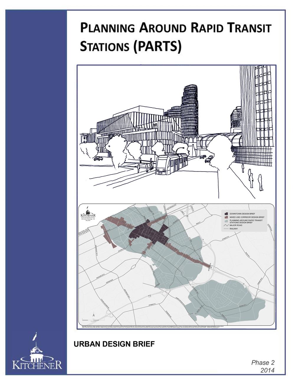
2 PLANNING AROUND RAPID TRANSIT STATIONS (PARTS) Introduction The ION rapid transit system will link Waterloo, Kitchener and Cambridge through a central transit corridor (CTC). There are a number of station stops identified in Kitchener. Along with improving access to existing places, the CTC will become the focus for new medium and high density residential, retail, commercial and employment uses and support the concentration of existing and planned residents and jobs. Comprehensive planning around all station areas will be a key to ensuring that new development positively contributes to our urban environment. Direction for the planning around station areas comes from several higher order policy and strategy documents, as illustrated below. These policies include: Places to Grow, Provincial Policy Statement, Regional Official Plan (ROP), Community Building Strategy (CBS), City of Kitchener Official Plan (OP), and Planning Around Rapid Transit Stations (PARTS). framework to leverage investment and to help shape how communities will be planned and built around the rapid transit system. The CBS identifies key directions for community building, placemaking and moving people within, to, and from the central transit corridor. It is desirable and important to have Station Study Areas Plans that will provide direction and guidance for growth and redevelopment in the Station Study Areas; to ensure that development and investments support and sustain the rapid transit system and allow for the effective prioritization of supporting infrastructure. Station Study Areas Through the CBS, an initial Corridor Wide Stations Study Area was identified as an 800m walking distance radii from the transit system, which was further refined by the City of Kitchener in Phase 1 of PARTS to identify the following Station Study Areas: Central Midtown Rockway Fairway Block Line Sportsworld This refinement also identified Focus and Influence Areas at each station stop. Focus areas are those lands, which due to their proximity to a station stop will be a significant focus of potential change and thus will require further study in the immediate term ( ). Influence areas are further away from the station stop, but still contribute to the role and function of the station study areas. Influence areas will not be the focus of change, but may provide opportunities for minor infilling where deemed appropriate. The Regional Official Plan (ROP) outlines the criteria that must be included in the plans for each Station Area, and the City s Official Plan (OP) includes new transit supportive policies that provide direction to future development within these areas and outlines their planned function. The Community Building Strategy (CBS) is a Region of Waterloo initiated 2014 City of Kitchener Part B: Design Briefs B-1


3 Vision for PARTS Together, through a comprehensive and collaborative public planning process, we will build well-connected, innovative, vibrant, inviting and inclusive station areas in which to live, work, shop, study and play. This vision builds on the Kitchener Strategic Plan, contributes to the land use vision for the City contained in the new Official Plan and will help guide the Station Study Area Plans. Corridor-Wide General Guidelines Manage Growth and Change Focusing and directing growth within Station Areas reinforces and optimizes public infrastructure investments, builds compact, sustainable and complete communities and encourages transit use. Goals for PARTS To articulate this vision, high-level goals specific to Kitchener were created to help guide the Station Study Area Plans. These goals are: Manage Growth and Change Ensure a Mix of Appropriate Land Uses Enhance Transportation Choice and Connectivity Enhance Placemaking, Safety, Community Design Guide Public and Private Investment PARTS Urban Design Brief Outline The vision, goals and general guidelines will provide some consistency across the Station Study Areas as there are many common guidelines. The purpose of this Urban Design Brief is to: provide direction for a design-based approach to the preparation of Station Area Plans/Secondary Plans for each Station Area; be refined with specific guidelines, standards and streetscape plans through the completion of each Station Area Plan/ Secondary Plan; Density and Development Patterns Rapid Transit Station Areas will be planned, designed and developed to: Accommodate growth. Establish new density and development patterns that are related to infrastructure and sustainable development considerations. Concentrate new development and highest densities close to the stations. In some instances this may be more appropriate at other key locations within the Focus Area in order to reflect existing conditions, constraints or to reduce conflicts. Establish minimum density targets within each Focus Area that reflects the desired urban condition for the area and that considers the range of targets within the entire corridor and the city. provide additional design direction for conserving stable neighbourhoods; and provide further design direction in the review of development applications in these areas. Transition from higher intensity development in the Focus Area to a less intense development pattern in the Influence Area. This Design Brief will apply to all Kitchener Rapid Transit Station Study Areas with the exception of Sportsworld. In the interim, this Brief will not apply to the Mixed Use Corridors or Downtown as those areas already have detailed design briefs which will continue to apply until a future consolidation/urban Design Manual review. Permit infill and redevelopment in Influence Areas where the characteristics of the existing neighbourhood is respected including building scale, height, massing, orientation, setback, architectural elements and materials City of Kitchener Part B: Design Briefs B-2

4 Ensure a Mix of Land Uses The type and mixture of land uses within the Station Areas will help create a sense of place and encourage a shift towards more sustainable modes of transportation and movement. Station Areas will contain different land uses. Some locations are, and will continue to be, significant areas for employment, residential or other uses. Some areas will evolve into a new range of uses, including mixed use. The evolution of land uses within each Station Area will occur at different rates throughout time. The transition to an appropriate mix of land uses within each Station Area will help generate transit ridership, reduce personal vehicle trips and contribute to a complete and healthy community. Enhance Transportation Choice and Connectivity The success of the rapid transit system and station study areas will be influenced by many factors including the provision of a range of inter-connected transportation options that are efficient, convenient, enjoyable, safe, easily navigable, continuous and barrier-free. Transportation Demand Management measures will be critical. Street Fabric, Pedestrian Priority and Parking New streets, laneways, pedestrian and cycling connections should be provided to achieve a highly connected network that offers route choice and creates new active transportation opportunities. Transit Supportive Land Uses Rapid Transit Station Areas will be planned, designed and built to: Locate transit-supportive uses such as high and medium density residential, office and mixed use, within close proximity to the station stop. Uses that are primarily auto-oriented and not conducive to a transit-supportive environment should be discouraged in Focus Areas. Include a variety of land uses to create multipurpose destinations. Establish a framework to encourage a mixture of appropriate uses within buildings. Provide active, pedestrian-oriented uses at key locations including the ground-floor of buildings. Design safe, logical and efficient routes for different modes of transportation, with priority given to pedestrians. Use parks and green space to provide pedestrian and cycling links to transit stations to enhance user experience. Provide enhanced, convenient pedestrian and cycling infrastructure and amenities. Preference is to facilities that can be maintained year-round. Identify locations to have wider than minimum sidewalks in areas of high pedestrian routes/volumes within Station Areas. Provide weather protection for transit users and pedestrians where possible. Provide clear and consistent way finding elements. Minimize vehicle and pedestrian points of conflict. Vehicular access points should be controlled to minimize disruption to traffic flow and new development may be required to share common driveways and provide for maneuverability between sites. Incorporate pedestrian, cycling, car sharing and carpooling amenities to facilitate the implementation of Transportation Demand Management measures City of Kitchener Part B: Design Briefs B-3

5 Establish parking standards that will complement the multi-modal transportation and pedestrianoriented design objectives, including maximum parking rates where appropriate. Identify key intersections and sites in Station Areas to concentrate building mass and locate landmark buildings with distinctive design features. Consider a park once environment to encourage walking between activities/uses. Podium parking above the ground level may be considered provided it includes active uses on the ground level of main public street(s) and is well integrated into the building design through techniques such as vertical and horizontal articulation, canopies, articulated entrances and appropriately scaled landscaping. Enhance Placemaking, Safety and Community Design New places, spaces and neighbourhoods will emerge and be shaped in areas around the rapid transit stations. To ensure that each of these is successful and vibrant, the design of station study areas must carefully integrate matters of built form, architecture, public realm, streetscape, place making, safety and universal design. Creating healthy, sustainable communities that reflect our natural heritage and cultural richness will require inspired and high quality design that is functional, diverse and inclusive. Building height and setback requirements should include both maximums and minimums. Maximum frontages may be limited to allow views of significant landmarks, natural features, cultural heritage resources, and to improve solar access and pedestrian permeability. Building design, particularly the ground floor facades, should carefully consider the public realm, include active uses and create a positive pedestrian experience. Orient buildings in commercial areas to contribute to the streetscape and be easily identifiable, inviting, continuous and permeable. Large retail tenant frontages should have several retail units interjected into the street frontage. Façade treatments should increase visual interest. Building height, built form, massing and architectural detailing should be used to ensure a compatible transition between new development and stable neighbourhoods. Built Form, Architecture, Views, Vistas and Skyline Respect natural and cultural heritage resources in the design of built form. Authentic and high quality design for building morphology, architectural detailing and material use is expected for all projects. Design infill to be rich in detail and enhance the public realm while responding to the established patterns of the street and neighbourhood. Encourage bird-friendly design and materials. Taller buildings should have a clear delineation between podium, middle and top elements through massing, materials and details to ensure towers are distinct, recognizable, and visually appealing City of Kitchener Part B: Design Briefs B-4


6 Architectural variety between buildings is encouraged and buildings should inter-relate in order to create complementary urban design. principles and adhere to Accessibility for Ontarians with Disabilities Act in Station Area Plans, streetscape plans and development applications. Special emphasis on safety and universal design will be applied at key locations near rapid transit stations. Placemaking and Streetscapes Design street-facing residential buildings to include visually distinct units with separate entrances and distinct delineation of public and private space. Design at-grade residential units to include measures that provide adequate privacy from the public sidewalk/street so that privacy walls and solid fences will not be required. Rear and side facades that have a public view should incorporate architectural detailing and include a quality of building material that is approaching the primary facades. Develop a placemaking vision along with for each Station Area that recognizes character locations, including the heritage aspects of neighbourhoods. Include a coordinated design for street furniture, transit facilities, intersections, lighting, vegetation, wayfinding and signage. Create a focal point(s) for activity within each Focus Area including features such as parks, plazas and gathering points. Integrate an appropriate range of public and private open spaces within each Station Area. Concentrate amenities and the provision of street furniture near rapid transit stations and along key access routes. Maintain or create view corridors through and between sites to visually link Station Areas to the community, parks and open space systems. Determine if special sign standards are required to respect building scale, architectural features and streetscape objectives. Create opportunities for sightlines and views to terminate at important features such as the station stops, community buildings, monuments, public art, and natural and cultural heritage resources. Create an attractive skyline by providing a variety of design expressions to articulate the top of tall buildings, including articulated rooftop designs with varying heights and setbacks. Sustainable Design New development/redevelopment should identify sustainable/ green building techniques to be implemented in the design and construction of sites and buildings. This shall include, but not limited to, energy and water conservation, waste management, environmental design, air quality benefits, trip reductions, climate change mitigation and adaptation, and other related techniques. Safety, CPTED and Universal Design Utilize Universal Design and Crime Prevention Through Environmental Design (CPTED) Buildings should address climate and seasonal changes and consider the use of shade, permeability, colour, light, greenery and natural materials to address both summer and winter conditions. Reduce urban heat island effect through landscaping, green/white roofs and other materials that have a high solar reflective index (SRI) City of Kitchener Part B: Design Briefs B-5
7 Guide Public and Private Investment Light Rail Transit is a significant catalyst for shaping the built form and streetscapes of our community into the future. Additional strategic investments in the infrastructure and public realm in the areas beyond the immediate LRT line and stations stops can potentially provide further amenities to leverage an area s marketability and livability. Determine and prioritize capital investments in streetscape improvements to enhance the public realm, connectivity and livability as part of the development catalyst package. Place emphasis on one or two key strategic investments in each Station Area within the first 10 years of LRT. Station Area Design Strategies This section provides a unique design strategy for each rapid transit Station Area based on specific design objectives and includes detailed standards and streetscape plans. Implementation will occur through municipal and public capital infrastructure projects, the development review process and other partnership or innovative methods. Central Station Area Investigate the feasibility of streetscape and connectivity enhancements during the replacement/upgrade of any hard infrastructure (sewers, roads, etc.). Strategically locate, design and build new or revised urban and green public spaces, including parks, within each Station Area to provide needed outdoor amenities for development, focal points for gathering and social activity, and to contribute to healthy and complete communities. Utilize semipublic and private urban and green spaces where appropriate to supplement the need for such spaces in Focus Areas for intensification. Follow a public and private public art investment strategy to strategically locate art in visible locations within each Station Area. Coordinate with tourism, heritage, way-finding and place-making. Midtown Station Area Rockway Station Area Fairway Station Area Block Line Station Area 2014 City of Kitchener Part B: Design Briefs B-6
DRAFT Northeast Quadrant of Kipling Avenue and Highway 7 DRAFT AUGUST 29, Goals Land Use. The goals of this Plan are to:
 AUGUST 29, 2017 12.15 Northeast Quadrant of Kipling Avenue and Highway 7 12.15.1 Goals 12.15.2 Land Use The goals of this Plan are to: 12.15.2.1 General Provisions: a) Ensure the development of a compact
URBAN DESIGN BRIEF URBAN DESIGN BRIEF 721 FRANKLIN BLVD, CAMBRIDGE August 2018
 URBAN DESIGN BRIEF URBAN DESIGN BRIEF 721 FRANKLIN BLVD, CAMBRIDGE August 2018 DESIGN BRIEF CONTENTS PART A 1.0 INTRODUCTION 2.0 DESCRIPTION & ANALYSIS OF SITE CONTEXT 3.0 DESIGN CONSTRAINTS AND OPPORTUNITIES
CONTENTS 8.0 LAND USE 8.1 GENERAL LAND USE 8.2 RESIDENTIAL 8.3 MIXED USE 8.4 COMMERCIAL 8.5 EMPLOYMENT LANDS
 8-2 Land Use 8.0 LAND USE CONTENTS 8.1 GENERAL LAND USE 8.1.1 Uses provided for in all Land Use Designations 8.1.2 Uses prohibited in Hazardous Lands, Hazardous Sites and Special Policy Areas 8.1.3 Uses
CONTENTS 6.1 URBAN DESIGN
 6-2 Urban Design and Sustainable Development 6.0 URBAN DESIGN AND SUSTAINABLE DEVELOPMENT CONTENTS 6.1 URBAN DESIGN 6.1.1 General Policies 6.1.2 The Public Realm 6.1.3 Streets and Blocks 6.1.4 Streetscapes
ELMVALE ACRES SHOPPING CENTRE MASTER PLAN
 ELMVALE ACRES SHOPPING CENTRE MASTER PLAN Contents 1.0 INTRODUCTION... 2 2.0 LOCATION... 2 3.0 EXISTING CONTEXT... 2 4.0 VISION & GUIDING PRINCIPLES... 2 5.0 LAND USE AND BUILT FORM... 4 5.1 St. Laurent
Town Center (part of the Comprehensive Plan)
") Town Center (part of the Comprehensive Plan) Mercer Island Town Center Looking North (2014) In 1994, a year-long process culminated in a set of design guidelines and code requirements for the Town Center
Town Center (part of the Comprehensive Plan) Mercer Island Town Center Looking North (2014) In 1994, a year-long process culminated in a set of design guidelines and code requirements for the Town Center
Mark-up of the effect of the proposed Bronte Village Growth Area OPA No.18 on the text of section 24, Bronte Village, of the Livable Oakville Plan
 Mark-up of the effect of the proposed Bronte Village Growth Area OPA No.18 on the text of section 24, Bronte Village, of the Livable Oakville Plan Notes: This document is provided for information purposes
Complete Neighbourhood Guidelines Review Tool
 Complete Neighbourhood Guidelines Review Tool Prepared By: City of Regina Planning Department October 2014 Page 1 of 14 Community Development Review Checklist for Secondary Plans and Concept Plans The
38 Queen s University Campus Master Plan Part 1
 38 Queen s University Campus Master Plan Part 1 46 The Campus at the City Scale Chapter 4 The Campus at the City Scale 39 Queen s is an urban University centrally located in Kingston. Decisions made by
Welcome to the Oakridge Centre Open House
 Welcome to the Oakridge Centre Open House Why is the City hosting this event? This open house is to inform you of a rezoning application submitted to the City of Vancouver to amend the existing CD-1 (Comprehensive
EXISTING COMPREHENSIVE PLAN
 EXISTING COMPREHENSIVE PLAN Town Center Land Use Element: V. LAND USE POLICIES Town Center Mercer Island's business district vision as described in "Your Mercer Island Citizen-Designed Downtown" was an
GO Station Mobility Hubs: Draft Precinct Plans. Committee of the Whole July 12, 2018
 GO Station Mobility Hubs: Draft Precinct Plans Committee of the Whole July 12, 2018 Purpose of this Workshop Present Draft Precinct Plans for the 3 GO Station Mobility Hubs Continue the conversations that
WELCOME and introduction
 1 WELCOME and introduction Mobility Hub Locations within Burlington STUDY OVERVIEW STUDY OBJECTIVES The City of Burlington is developing four Area Specific Plans, one for each of Burlington s Mobility
Port Credit Local Advisory Panel October 20 th Meeting
 Port Credit Local Advisory Panel October 20 th Meeting Focus Of This Evening s Meeting: 1. Hurontario Main Street Higher Order Transit Study 2. Port Credit Mobility Hub & GO Station Parking Structure Study
HIGHLAND VILLAGE GREEN URBAN DESIGN PRINCIPLES/GUIDELINES
 URBAN DESIGN GUIDING PRINCIPLES/GUIDELINES CONTEXT/CHARACTER The City of Calgary s Municipal Development Plan (MDP), Transit-Oriented Development (TOD) Policy Guidelines and Main Street/Corridor policy
WEST LOOP DESIGN GUIDELINES CHECKLIST
 WEST LOOP DESIGN GUIDELINES CHECKLIST Section 1.0 General Strategies 1.1 DESIGN EXCELLENCE: ENCOURAGE HIGH QUALITY AND INNOVATIVE DESIGN OF NEW BUILDINGS WITHIN THE WEST LOOP WITHOUT BEING PRESCRIPTIVE
Uptown Rideau Street Secondary Plan [Amendment #166, January 12, 2016]
![Uptown Rideau Street Secondary Plan [Amendment #166, January 12, 2016]](/thumbs/76/73760497.jpg "Uptown Rideau Street Secondary Plan [Amendment #166, January 12, 2016]") [Amendment #166, January 12, 2016] The policies of this Secondary Plan are in effect, save and except for the property at 560 Rideau Street, for which there remains a site specific appeal to this Secondary
[Amendment #166, January 12, 2016] The policies of this Secondary Plan are in effect, save and except for the property at 560 Rideau Street, for which there remains a site specific appeal to this Secondary
Urban Design. in the City of Kitchener. MUDR Presentation May 2010
 Urban Design in the City of Kitchener MUDR Presentation May 2010 Highlights Direction: long term commitment to urban design in Kitchener Themes: density, mixed use, community focal points, transit, accessibility
5.1 Site Plan Guidelines
 5. Community Core Guidelines Development of the Community Core will take place by plan of subdivision and site plan approval. It will occur in a phased manner that will reflect the timing of residential
[PLANNING RATIONALE] For Site Plan Control and Lifting of Holding Zone By-Law 101 Champagne Avenue. May 23, 2014
![[PLANNING RATIONALE] For Site Plan Control and Lifting of Holding Zone By-Law 101 Champagne Avenue. May 23, 2014](/thumbs/75/71599615.jpg "[PLANNING RATIONALE] For Site Plan Control and Lifting of Holding Zone By-Law 101 Champagne Avenue. May 23, 2014") [PLANNING RATIONALE] For Site Plan Control and Lifting of Holding Zone By-Law 101 Champagne Avenue May 23, 2014 Contents 1.0 Introduction... 2 2.0 Site Context... 2 2.1 Adjacent Uses... 2 Figure 1: Site
[PLANNING RATIONALE] For Site Plan Control and Lifting of Holding Zone By-Law 101 Champagne Avenue May 23, 2014 Contents 1.0 Introduction... 2 2.0 Site Context... 2 2.1 Adjacent Uses... 2 Figure 1: Site
East Bayshore Road Neighbourhood
 East Bayshore Road Neighbourhood Northridge Property Management Urban Design Brief 3195 East Bayshore Road City of Owen Sound January 2016 East Bayshore Road Neighbourhood Northridge Property Management
Official Plan Review: Draft Built Form Policies
 PG.30.1 REPORT FOR ACTION Official Plan Review: Draft Built Form Policies Date: May 15, 2018 To: Planning and Growth Management Committee From: Chief Planner and Executive Director, City Planning Division
and services The protection and conservation of environmentally significant and sensitive natural heritage features and functions.
 6. Land Use 6.0 Preamble A healthy and livable city is one in which people can enjoy a vibrant economy and a sustainable healthy environment in safe, caring and diverse neighbourhoods. In order to ensure
CITY OF PUYALLUP. Background. Development Services
 CITY OF PUYALLUP Development Services 333 South Meridian Puyallup WA 98371 To: City Council From: Katie Baker, AICP, Planning Division Re: South Hill Neighborhood Plan Adoption Date: (Meeting date: February
Urban Design Direction for Oakville. Endorsed by Council on May 12, 2014 Endorsed by Council , Version - 1.0
 Urban Design Direction for Oakville Endorsed by Council on May 12, 2014 Endorsed by Council 01.30.2014, Version - 1.0 Urban Design Direction for Oakville Livable by Design Manual Urban Design Direction
FORMER CANADIAN FORCES BASE (CFB) ROCKCLIFFE SECONDARY PLAN. Official Plan Amendment XX to the Official Plan for the City of Ottawa
 ROCKCLIFFE SECONDARY PLAN. Official Plan Amendment XX to the Official Plan for the City of Ottawa") FORMER CANADIAN FORCES BASE (CFB) ROCKCLIFFE SECONDARY PLAN Official Plan Amendment XX to the Official Plan for the City of Ottawa 1 INDEX THE STATEMENT OF COMPONENTS PART A THE PREAMBLE PAGE Purpose...
FORMER CANADIAN FORCES BASE (CFB) ROCKCLIFFE SECONDARY PLAN Official Plan Amendment XX to the Official Plan for the City of Ottawa 1 INDEX THE STATEMENT OF COMPONENTS PART A THE PREAMBLE PAGE Purpose...
Town of Cobourg Heritage Master Plan. Statutory Public Meeting
 Town of Cobourg Heritage Master Plan Statutory Public Meeting April 25 th 2016 Presentation Overview 1. Introduction 2. Project background and schedule overview 3. Review of strategic direction content
URBAN DESIGN BRIEF 181 Burloak Drive, Oakville
 URBAN DESIGN BRIEF 181 Burloak Drive, Oakville February 2017 Our File: 1730B 230-7050 WESTON ROAD / WOODBRIDGE / ONTARIO / L4L 8G7 / T: 905 761 5588/ F: 905 761 5589/WWW.MHBCPLAN.COM TABLE OF CONTENTS
The West Vaughan Employment Area Secondary Plan Policies
 Part 2: The West Vaughan Employment Area Secondary Plan Policies 2.1 General Policies It is the policy of Council: 2.1.1. That the West Vaughan Employment Area (the WVEA), identified on Schedule 1, will
Old East Village Dundas Street Corridor Secondary Plan
 Old East Village Dundas Street Corridor Secondary Plan DRAF T February 2019 Contents 1.0 INTRODUCTION 1 1.1 Background 1 1.2 Location 2 1.3 Purpose and Use 3 1.4 Vision and Principles 4 2.0 CHARACTER
QUEEN-RIVER SECONDARY PLAN
 34 QUEEN-RIVER SECONDARY PLAN 34. QUEEN RIVER SECONDARY PLAN 1. INTRODUCTION The Queen-River area is approximately 6.4 hectares and is located at the eastern edge of the Downtown as shown on Map 34-1.
Clairtrell Area Context Plan
 Clairtrell Area Context Plan March 2005 Urban Development Services City Planning Contents 1. Introduction... 4 2. Development Structure... 6 2.1 Streets... 7 2.1.1 Sheppard Avenue and Bayview Avenue...
Chapter 1: Introduction
 Chapter 1: Introduction The Penn Avenue Community Works Corridor Vision and Implementation Framework presents an integrated communitybased vision and a coordinated, long-term implementation framework for
4.0 Design Guidelines For The Village Centre. South fields Community Architectural Design Guidelines Town of Caledon
 4.0 Design Guidelines For The Village Centre 4.0 Design Guidelines for the Village Centre The Village Centre is the focal point of the entire South Fields Community and is designed as a traditional commercial
SECTION ONE: INTRODUCTION. introduction
 introduction 1 INTRODUCTION Since it was first established in 1843 as a trading post for the Hudson s Bay Company, Victoria has evolved into a Provincial capital city that is recognized across Canada and
4- PA - LD - LIVELY DOWNTOWN. LD - Background
 4- PA - LD - LIVELY DOWNTOWN LD - Background The downtown has been the service centre for the community since the city s inception and the area continues to supply people with their personal services,
1.3 TRANSIT VISION 2040 FROM VISION TO ACTION THEME 1: PUTTING TRANSIT AT THE CENTRE OF COMMUNITIES. Fully integrate transit with community planning
 TRANSIT VISION 2040 FROM VISION TO ACTION TRANSIT VISION 2040 defines a future in which public transit maximizes its contribution to quality of life with benefits that support a vibrant and equitable society,
New-Cast Mixed-use Development Proposal King Street West, Newcastle, Ontario
 URBAN DESIGN BRIEF New-Cast Mixed-use Development Proposal King Street West, Newcastle, Ontario TABLE OF CONTENTS: 1.0 Executive Summary 2.0 Creating Vibrant and Sustainable Urban Places: Excerpts from
appendix and street interface guidelines
 appendix five: building and street interface guidelines appendix 5 building and street interface guidelines BOULEVARDS Boulevards are generally characterized by higher levels of traffic movement at higher
Policies and Code Intent Sections Related to Town Center
 Policies and Code Intent Sections Related to Town Center The Town Center Vision is scattered throughout the Comprehensive Plan, development code and the 1994 Town Center Plan. What follows are sections
Corridor Transformation Strategy
 Corridor Transformation Strategy County Road 22 Special Planning Area Design Guidelines January 2012 D14-06017 Corridor Transformation Strategy County Road 22 Special Planning Area Corridor Design Guidelines
Animating the Rideau Canal December 2013
 Executive Summary Animating the Rideau Canal December 2013 Why study the Rideau Canal? The Rideau Canal has been an important part of Ottawa throughout its history, and has shaped and been shaped by the
Tel: (705) Fax: (705)
 Fax: (705)") 521 and 525 Essa Road City of Barrie Tel: (705) 812-3281 Fax: (705) 812-3438 Email: INFO@IPSCONSULTINGINC.com 1 5 0 D U N L O P S T R E E T E A S T, S U I T E 2 0 1, B A R R I E O N T A R I O L 4 M 1 B
521 and 525 Essa Road City of Barrie Tel: (705) 812-3281 Fax: (705) 812-3438 Email: INFO@IPSCONSULTINGINC.com 1 5 0 D U N L O P S T R E E T E A S T, S U I T E 2 0 1, B A R R I E O N T A R I O L 4 M 1 B
SCHEDULE 'A' TO BY-LAW as Amended by AMENDMENT NO. 90 TO THE WHITBY OFFICIAL PLAN
 SCHEDULE 'A' TO BY-LAW 6413-10 as Amended by 6553-11 AMENDMENT NO. 90 TO THE WHITBY OFFICIAL PLAN SECTION A: GROWTH PLAN CONFORMITY PURPOSE: LOCATION: BASIS: The purpose of this Amendment is to: conform
TORONTO COMPLETE STREETS GUIDELINES
 TORONTO COMPLETE STREETS GUIDELINES Presentation by Fiona Chapman, Manager, Pedestrian Projects Public Realm Section, Transportation Services, City of Toronto June 2017 PURPOSE OF THE PROJECT To develop
Plano Tomorrow Vision and Policies
 Plano Tomorrow Vision and Policies PLANO TOMORROW PILLARS The Built Environment The Social Environment The Natural Environment The Economic Environment Land Use and Urban Design Transportation Housing
6. DOWNTOWN. The Downtown Element focuses on supporting and expanding the vitality and enhancement of Downtown Chico as the City s central core.
 VISION In 2030, Downtown Chico is the heart of the community and the center of cultural activity. Engaging and active at the street level, it is a multi-story, mixed-use hub, with specialty retail, restaurants,
Silverdale Regional Center
 Silverdale Regional Center Vision for Silverdale Regional Center The Silverdale Regional Center Plan (Plan) will guide the evolution of the Silverdale Regional Center from a collection of strip malls and
Cit of Kitchener Ur 6 an Design Manual PARTA. Desi n for _--::
 Cit of Kitchener Ur 6 an Design Manual Date PARTA Year ) Desi n for k Nodes Corridors _--:: Section Page 01 of 12 2 INTRODUCTION Purpose & Application Nodes and Corridors have been identified as key intensification
Highland Village Green Design Guidelines
 Highland Village Green Design Guidelines Publishing Information Title Highland Village Green Design Guidelins Author The City of Calgary Status DRAFT - Proposed document subject to changes Additional Copies
TALL BUILDING GUIDELINES
 TALL BUILDING GUIDELINES Urban Design Guidance for the Site Planning and Design of Tall Buildings in Milton May, 2018 A Place of Possibility Contents 1.0 INTRODUCTION 1 1.1 What is a Tall Building? 2
178 Carruthers Properties Inc.
 178 Carruthers Properties Inc. Planning Rationale for 178 Carruthers Avenue Site Plan Control Application June 2014 Table of Contents 1.0 Introduction 2.0 Overview of Subject Property 3.0 Current Zoning
*** DRAFT 2 FOR PUBLIC REVIEW ***
 6.7 The area is generally bounded by the Red Hill Valley Parkway to the west, Lake Avenue to the east, the Queen Elizabeth Way (QEW) to the north, and by the properties just south of Queenston Road to
4.1.3 LAND USE CATEGORIES
 4.1.3 LAND USE CATEGORIES a. City Center District The City Center District incorporates the existing character and mix of uses in downtown Belmont to encourage redevelopment and new development in keeping
CONTENTS 2.0 A FRAMEWORK FOR SUSTAINABLE GROWTH 2.1 MANAGING SUSTAINABLE GROWTH THE VISION TO GOALS AND OBJECTIVES 2.3 MARKHAM STRUCTURE
 2 A Framework for Sustainable Growth 2.0 A FRAMEWORK FOR SUSTAINABLE GROWTH CONTENTS 2.1 MANAGING SUSTAINABLE GROWTH THE VISION TO 2031 2.2 GOALS AND OBJECTIVES 2.2.1 Protecting the Natural Environment
New Street Proposed Redevelopment Architecture & Urban Design Brief
 2130 2136 New Street Proposed Redevelopment Architecture & Urban Design Brief Prepared By: Cynthia Zahoruk Architect Inc. 3077 New Street, Burlington, ON, L7N 1M6 TABLE OF CONTENTS Background and Objective
WELLINGTON STREET WEST COMMUNITY DESIGN PLAN
 36 3.CDP POLICIES 37 Wellington Street West CDP Vision Statement 38 3.1 Introduction 3.1.1 Purpose The development of buildings and public spaces is influenced by a variety of factors over time. City of
2.0 A FRAMEWORK FOR SUSTAINABLE GROWTH CONTENTS
 2-2 A Framework for Sustainable Growth 2.0 A FRAMEWORK FOR SUSTAINABLE GROWTH CONTENTS 2.1 MANAGING SUSTAINABLE GROWTH THE VISION TO 2031 2.2 GOALS AND OBJECTIVES 2.2.1 Protecting the Natural Environment
burlington mobility hubs study Downtown Burlington Mobility Hub
 burlington mobility hubs study Downtown Burlington Mobility Hub Draft Precinct Plan Workbook PIC #3, September 7, 2017 downtown mobility hub objectives City staff and their consultants are proposing an
Welcome. Walk Around. Talk to Us. Write Down Your Comments
 Welcome This is an information meeting introducing the applications for proposed redevelopment of the Yorkdale Shopping Centre site at 3401 Dufferin Street and 1 Yorkdale Road over the next 20+ years,
CITY COUNCIL AGENDA REPORT
 CITY COUNCIL AGENDA REPORT Subject: COUNCIL MOTION LRT ALIGNMENT REMOVAL FROM THE TRANSPORTATION MASTER PLAN On February 10, 2016 Councillor Hughes provided notice in accordance with Section 23 of Procedure
The Master Plan Framework
 The Master Plan Framework The East Harbour Master Plan advances the development of 60 acres of former industrial lands east of the Don River. The Master Plan outlines a vision for a vibrant, transit-oriented
PUBLIC OPEN HOUSE HURONTARIO-MAIN CORRIDOR SECONDARY PLAN
 PUBLIC OPEN HOUSE HURONTARIO-MAIN CORRIDOR SECONDARY PLAN Tuesday, February 28, 2012 6pm 9pm 1 st Floor Atrium, City Hall 2 Wellington Street West, Brampton 1 POLICY FRAMEWORK The 2006 Provincial Growth
THE GARDEN CITY PLAN. City of St. Catharines Official Plan. City of St. Catharines
 THE GARDEN CITY PLAN City of St. Catharines Official Plan City of St. Catharines August 2010 APPROVAL INFORMATION This Official Plan of the City of St. Catharines Planning Area, known as the Garden City
4. INDUSTRIAL 53 CASTLE ROCK DESIGN
 4. INDUSTRIAL 53 CASTLE ROCK DESIGN CASTLE ROCK DESIGN 54 4. INDUSTRIAL Overview Well-designed and attractive industrial centers are the product of blending economic realities with both functional and
URBAN DESIGN BRIEF. 2136&2148 Trafalgar Road. Town of Oakville
 URBAN DESIGN BRIEF 2136&2148 Trafalgar Road Town of Oakville Prepared By: METROPOLITAN CONSULTING INC For 2500674 Ontario Inc November 2016 TABLE OF CONTENTS Page No. 1.0 Introduction/Description of Subject
FRUITVALE TRANSIT VILLAGE (Phase 2) Residential Project
 Residential Project") FRUITVALE TRANSIT VILLAGE (Phase 2) Residential Project DEVELOPER: SIGNATURE PROPERTIES ARCHITECT: HKIT ARCHITECTS April 23, 2010 TABLE OF CONTENTS 3 Vision 4 Description of Site 5 Guiding Concepts 6
FRUITVALE TRANSIT VILLAGE (Phase 2) Residential Project DEVELOPER: SIGNATURE PROPERTIES ARCHITECT: HKIT ARCHITECTS April 23, 2010 TABLE OF CONTENTS 3 Vision 4 Description of Site 5 Guiding Concepts 6
NEW REGIONAL OFFICIAL PLAN HIGH LEVEL PROCESS & FRAMEWORK
 NEW REGIONAL OFFICIAL PLAN HIGH LEVEL PROCESS & FRAMEWORK Why A New Official Plan Originally the role of Regionally Planning and content of Regional Official Plan (1970s) primarily focused on protecting
Midtown Oakville will be a vibrant, transit-supportive, mixed use urban community and employment area.
 Livable Oakville Part E: Growth Areas, Special Policy Areas and Exceptions 20. MIDTOWN OAKVILLE 20.1 Goal The interchange of Trafalgar Road and the QEW and the Oakville GO Station are major entry points
TABLE OF CONTENTS 1.0 INTRODUCTION... 3
 TABLE OF CONTENTS 1.0 INTRODUCTION... 3 1.1. BACKGROUND... 3 1.2. THE PROPOSAL... 5 2.0 EXISTING POLICY FRAMEWORK... 5 2.1. PROVINCIAL POLICY STATEMENT (PPS)... 5 2.2. CITY OF LONDON OFFICIAL PLAN (OP)...
Official Plan Review
 Official Plan Review Summary Report - The Built Environment August 2014 Part 1: Introduction Planning for a healthy, prosperous and sustainable community is an important goal for our municipality. From
URBAN DESIGN BRIEF REPORT
 URBAN DESIGN BRIEF REPORT PREPARED FOR 2568401 ONTARIO INC NEW GASBAR, CONVENIENCE STORE & CARWASH DEVELOPMENT @ 1509 FANSHAWE PARK ROAD WEST LONDON, ONTARIO GAMA ENGINEERING INC. PROJECT NUMBER 1669 PREPARED
CAMBIE CORRIDOR PLAN
 1 WELCOME TO THE OPEN HOUSE PUBLIC REALM PLAN - CAMBIE CORRIDOR Thank you for coming to the Cambie Corridor Public Realm Open House! Place a dot where you live Please provide us with your comments and
Workshop 3. City of Burlington Waterfront Hotel Planning Study. September 14, The Planning Partnership
 Workshop 3 City of Burlington Waterfront Hotel Planning Study September 14, 2017 The Planning Partnership The Waterfront Hotel Planning Study 01 The Brant & Lakeshore Planning Study will establish a Strategic
K. SMART ASSOCIATES LIMITED
 Planning Justification Report Zoning By-Law Amendment 185 King Street North Waterloo, Ontario April 7th, 2017 Project Reference Number 16-245 K. SMART ASSOCIATES LIMITED CONSULTING ENGINEERS AND PLANNERS
Sustainable Growth. Sustainable Growth
 2 Sustainable Growth Sustainable Growth SUSTAINABLE GROWTH 2.1 COMMUNITY VISION... 2-5 2.2 THE CITY SYSTEM... 2-7 2.2.1 AREAS... 2-7 2.2.2 CITY-WIDE SYSTEMS... 2-8 2.2.3 PROVINCIAL PLAN BOUNDARIES AND
Appendix A COMMUNITY IMPROVEMENT PLAN DESIGN GUIDELINES
 Appendix A COMMUNITY IMPROVEMENT PLAN DESIGN GUIDELINES INTRODUCTION The continuous and desirable improvement of Arnprior requires a clear understanding of what is envisioned for the Town. These Design
SUBCHAPTER 4-B GUIDELINES FOR THE B-3 COMMERCIAL CHARACTER AREA
 1 SUBCHAPTER 4-B GUIDELINES FOR THE B-3 COMMERCIAL CHARACTER AREA Downtown Bozeman should be the location of buildings of greatest height and intensity in the community. The following guidelines apply
13 THORNHILL YONGE STREET STUDY IMPLEMENTATION CITY OF VAUGHAN OPA 669 AND TOWN OF MARKHAM OPA 154
 13 THORNHILL YONGE STREET STUDY IMPLEMENTATION CITY OF VAUGHAN OPA 669 AND TOWN OF MARKHAM OPA 154 The Planning and Economic Development Committee recommends the adoption of the recommendations contained
Contact: Alex Taranu ( ) or Karl Walsh ( )
 or Karl Walsh ( )") Date: 09 September 2005 File: Subject: P03.DUDS Downtown Urban Design Vision Study Report Contact: Alex Taranu (905 874 3454) or Karl Walsh (905 874 2331) OVERVIEW Staff has produced an Urban Design Vision
Date: 09 September 2005 File: Subject: P03.DUDS Downtown Urban Design Vision Study Report Contact: Alex Taranu (905 874 3454) or Karl Walsh (905 874 2331) OVERVIEW Staff has produced an Urban Design Vision
The Five Components of the McLoughlin Area Plan
 The Five Components of the McLoughlin Area Plan This documents contains the complete language of the five components of the McLoughlin Area Plan: The Vision Statement The Values The Guiding Principles
Port Lavaca Future Land Use
 Port Lavaca Future Land Use Introduction The City of Port Lavaca is beginning to see sustained growth, after many years of relative stable population. New single family homes, apartments, and businesses
2.0 A FRAMEWORK FOR SUSTAINABLE GROWTH CONTENTS
 2-2 A Framework for Sustainable Growth 2.0 A FRAMEWORK FOR SUSTAINABLE GROWTH CONTENTS 2.1 MANAGING SUSTAINABLE GROWTH THE VISION TO 2031 2.2 GOALS AND OBJECTIVES 2.2.1 Protecting the Natural Environment
The University District envisions, in its neighborhood
 Envisioning the University District Link Light Rail in Seattle s neighborhoods CIY OF SEALE CONCEP-LEVEL SAION AREA PLANNING RECOMMENDAION RESOLUION # 30165 EXHIBI L Vision 08.2000 he University District
PUBLIC RIGHT-OF-WAY IN THIS CHAPTER PUBLIC REALM
 PUBLIC RIGHT-OF-WAY This section provides design guidelines for improvements in the public right-of-way. The public right-of-way refers to streets, sidewalks, non-vehicular thoroughfares, parks and greenways
CITY OF LANGLEY OFFICIAL COMMUNITY PLAN BYLAW, 2005, NO APPENDIX II - REGIONAL CONTEXT MAP
 CITY OF LANGLEY OFFICIAL COMMUNITY PLAN BYLAW, 2005, NO. 2600 APPENDIX II - REGIONAL CONTEXT MAP ± Legend Agricultural Mixed Employment Industrial Conservation & Recreation Regional City Centre Urban Containment
CHAPTER 5: GUIDING PRINCIPLES
 CHAPTER 5: GUIDING PRINCIPLES The following 10 principles were developed based on public consultation, planning policy and the background analysis conducted during Phase 1. The Guiding Principles significantly
Urban Design Brief. 875 Wellington Road. Proposed One-Storey Fast Food Restaurant and Two-Storey Restaurant. Wellington Harlech Centre Inc.
 Urban Design Brief 875 Wellington Road Proposed One-Storey Fast Food Restaurant and Two-Storey Restaurant Wellington Harlech Centre Inc. Prepared By: (519) 433-7587 info@yorkdev.ca May 3 rd 2013 1 Table
YONGE STEELES CORRIDOR SECONDARY PLAN. Young + Wright / IBI Group Architects Dillon Consulting Ltd. GHK International (Canada) Ltd.
 Ltd.") PART A: PREAMBLE 1.0 PURPOSE The purpose of this Secondary Plan is to provide a development framework for intensification of the Yonge/ Steeles corridor including the north side of Steeles Avenue West
PART A: PREAMBLE 1.0 PURPOSE The purpose of this Secondary Plan is to provide a development framework for intensification of the Yonge/ Steeles corridor including the north side of Steeles Avenue West
SECTION II SECTION II STATEMENT OF GOALS, OBJECTIVES, PRINCIPLES, ASSUMPTIONS, POLICIES AND STANDARDS
 STATEMENT OF GOALS, OBJECTIVES, PRINCIPLES, ASSUMPTIONS, POLICIES AND STANDARDS 1 2 STATEMENT OF GOALS, OBJECTIVES, PRINCIPLES, ASSUMPTIONS, POLICIES AND STANDARDS INTRODUCTION The New Jersey Municipal
Bel-Air Lexus Automobile Service Station
 Bel-Air Lexus Automobile Service Station Design Brief 443-447 McArthur Avenue Ottawa April 30, 2015 14-1299-MCA Site Details Application: Site Plan Control Legal Description and Municipal Addresses: 443
WITNESS STATEMENT Of. Ronald Blake. On behalf of the Intervenor The Corporation of the City of Markham
 Filed: 2013-06028 EB-2012-0451 Exhibit L.EGD.COM.2 Page 1 of 7 WITNESS STATEMENT Of Ronald Blake On behalf of the Intervenor The Corporation of the City of Markham In the matter of an application by Enbridge
Figure 3-1: Public Realm Plan
 3 Public Realm Figure 3-1: Public Realm Plan 3.1 Public Realm Concept The public realm concept for the Little Mountain site integrates a clear and accessible movement network with public spaces for social
Regency Developments. Urban Design Brief. Holyrood DC2 Rezoning
 Regency Developments Urban Design Brief Holyrood DC2 Rezoning Stantec Consulting Ltd. 7-31-2017 1. Overview Regency Developments intends to rezone the lands located at 8510 and 8511 93 Avenue, within the
Buildings may be set back to create small plazas provided that these setbacks do not substantially disrupt the street wall s continuity.
 6-22 Community Design Street Walls and Street-front Setbacks The siting of buildings will play a critical role in establishing the character and sense of place for the District. Siting buildings at the
WELCOME. The Yonge-Eglinton area has experienced significant growth and change in the last decade.
 WELCOME DID YOU KNOW? MIDTOWN IS REPRESENTED BY 3 CITY COUNCILLORS: WARD 16 EGLINTON-LAWRENCE WARD 22 ST. PAUL S WARD 25 DON VALLEY WEST Midtown in Focus: Building a Livable Yonge-Eglinton The Yonge-Eglinton
Corridor Vision. 1Pursue Minnehaha-Hiawatha Community Works Project. Mission of Hennepin County Community Works Program
 1Pursue Minnehaha-Hiawatha Community Works Project Minnehaha-Hiawatha Community Works is a project within the Hennepin Community Works (HCW) program. The mission of the HCW program is to enhance how the
Rosslyn Plaza PDSP (SP #422) SPRC Staff Presentation
 SPRC Staff Presentation") Rosslyn Plaza PDSP (SP #422) SPRC Staff Presentation ote Guiding Principles included in this document are taken from the latest working draft of the Guiding Principles dated. The illustrations included
Rosslyn Plaza PDSP (SP #422) SPRC Staff Presentation ote Guiding Principles included in this document are taken from the latest working draft of the Guiding Principles dated. The illustrations included
Hockessin Community Redevelopment Plan
 Hockessin Community Redevelopment Plan 3.1 Introduction The Community Redevelopment Plan for the Village of Hockessin is the result of the people s vision for a distinct village center that serves as the
Downtown Streetscape Manual & Built Form Standards
 City of Guelph Downtown Streetscape Manual & Built Form Standards July 2014 Prepared by Brook McIlroy Inc. in association with Unterman McPhail Associates and McCormick Rankin Inc. City of Guelph Downtown