Stage 2 ION: Light Rail Transit (LRT) from Kitchener to Cambridge
|
|
|
- Tyler Phillips
- 5 years ago
- Views:
Transcription


1 Stage 2 ION: Light Rail Transit (LRT) from Kitchener to Cambridge Public Consultation Centre No. 3 Cambridge City Hall, November 21, 2 8 p.m. Preston Memorial Auditorium, November 28, 4 8 p.m. Public Information Package November 2017
2 Table of contents Section Page 1...Light Rail Transit in Waterloo Region Why are we here? How will my input be used? What we heard at Public Consultation Centre No Development of new route alternatives South Kitchener North Cambridge South Cambridge and Downtown Cambridge Terminal What are the next steps? Public consultation How do I stay involved? Contact information...9 Appendices: A Evaluation process and criteria B Study timeline C Preliminary potential route, February 2017 D Route alternative maps List of maps: Map C-1: Preliminary potential route as presented at PCC No. 2 (February-March 2017) Map D-1: South Kitchener Route alternative Map D-2: North Cambridge Route suggestions Map D-3: North Cambridge Route alternatives Map D-4: North Cambridge Route challenges Map D-5: South Cambridge Route alternatives ION project website: regionofwaterloo.ca/rapidtransit Phone: ext TTY: ION@regionofwaterloo.ca Stage 2 website:
3 Stage 2 ION: LRT from Kitchener to Cambridge Public Consultation Centre No. 3 Public Information Package 1.0 Light Rail Transit in Waterloo Region In June 2011, Region of Waterloo Council approved a staged approach to implement light rail transit (LRT) from Waterloo to Cambridge. In 2014, Regional Council awarded GrandLinq the contract to design, build, finance, operate and maintain Stage 1 ION LRT. Stage 1 ION (currently in testing phase) includes LRT from Waterloo to Kitchener and Bus Rapid Transit (BRT) from Kitchener to Cambridge (launched September 2015). Stage 1 LRT service is expected to launch in Stage 2 ION will see BRT service replaced by LRT, creating a continuous LRT system across the Region s three urban centres. For more information on the background and history of rapid transit in the Region please refer to The ION Story handout, available at this Public Consultation Centre and online Why are we here? In February and March 2017, the Region held its second Public Consultation Centre (PCC No. 2) for Stage 2 ION to present the evaluation results and the Preliminary Potential Route from Kitchener to Cambridge. The Region received significant feedback on the North Cambridge segment between Sportsworld and Hespeler Road (see Map C-1). In response to that feedback, the Region is examining additional alternatives for this segment. Since March 2017, the Region has also developed new routes for Downtown Cambridge and explored the option of using part of Highway 8 in South Kitchener (see Map D-1). Public input is important to the Region and there are several opportunities for you to comment on the project. The purpose of this Public Consultation Centre (PCC) is to: Summarize the comments received at PCC No. 2 and how these comments have influenced the route selection process Present new routes for South Kitchener, North Cambridge and South Cambridge Describe how all of these routes are being evaluated Hear your feedback 3.0 How will my input be used? Feedback received at PCC No. 2 has helped shape the direction of this study and has resulted in the examination of new routes for ION. Your comments will be used as input to the evaluation of these route alternatives. 1

4 4.0 What we heard at Public Consultation Centre No. 2 (PCC No. 2) Public Consultation Centre No. 2 was held in February and March Approximately 350 people attended the PCCs. Local residents were notified of the PCCs through s, letters, on-street advertising, social media posts, and newspaper advertising. Around 380 written submissions were received during and after the PCCs. Of the comments received, several common themes were identified. Of the comments that were generally supportive of the Preliminary Potential Route, residents most often cited these reasons: Coverage: Residents were in favour of the areas serviced by light rail transit (LRT) including commercial or residential areas, the connections to transit hubs, or site specific areas such as Preston, Galt, Fairview Park Mall, Sportsworld and Hespeler Road. They were also in favour of the regional connection the route would provide connecting residents of Cambridge to Kitchener and Waterloo. Environmental Benefits: Residents identified the environmental benefits that LRT would bring, such as pollution reduction by providing a more sustainable transportation option, as a reason for supporting the Stage 2 route. Redevelopment Potential: A number of residents were in favour of the growth and development that LRT would attract, included transit-oriented development that focuses on walking, cycling, and transitfriendly communities. Transportation: Residents approved of the Preliminary Potential Route avoiding busy intersections such as King Street at Fairway Road, Hespeler Road at Pinebush Road and at the Delta. Residents support an alternative to automobile travel with increasingly congested roads in the Region. The affordability of a stronger transit network in comparison to automobile travel was identified as well. Most of the comments that identified challenges or concerns were area-specific. Of these areaspecific concerns, a majority were focused on the Preliminary Potential Route segment in the Preston community (N3). The most frequently cited concerns with N3 included: The extent of property acquisition (primarily residential) to accommodate LRT on Moore Street and Eagle Street Effects on the character of the community along Moore Street and Eagle Street Impacts to existing traffic, as well as additional auto and/or freight traffic Heritage conservation Potential intrusion into natural areas, and the need to relocate or realign walking and cycling trails Noise and aesthetic impacts. 2
5 5.0 Development of new route alternatives 5.1 South Kitchener Why examine an additional route alternative? The Preliminary Potential Route, named F2a-K2, was presented at PCC No. 2 and is shown in Map C-1. While this alternative has fewer property and traffic impacts than the other alternatives, there were some drawbacks: A new Grand River crossing with First Nation interests and impacts on the natural environment Relatively higher travel time, and The need for a more complex bridge for River Road over Highway 8 The F2a-K2 route was initially preferred because of the potential for a stop at Grand River Hospital s Freeport campus, which was noted in a number of comments at PCC No. 2. However, since the hospital is located on a steep hill relative to King Street, it will be difficult for many people to comfortably make the connection to ION. Grand River Transit has studied the area, consulted with management at Grand River Hospital, and concluded that the hospital can be better served by frequent bus service directly from the Fairway LRT station. The Region is now working with the Ministry of Transportation to explore the opportunity of following the Highway 8 right-of-way for LRT. This option would significantly improve travel time for the overall LRT network. What options are being considered? Map D-1 shows the new LRT route alternative along the west side of Highway 8 (F2b-K3b). The Project Team explored options on both sides of Highway 8, and in the median. Options on the west side of Highway 8 have fewer engineering challenges. Locating LRT close to the existing highway will minimize environmental impacts, but it must have a minimum clearance from, and be independent of, the existing highway. 5.2 North Cambridge Why examine additional route alternatives? At the first PCC for this project in November 2015 (PCC No. 1), the most frequent comment was support for an LRT stop in Preston. The evaluation process that resulted in the Preliminary Potential Route showed there are significant ridership benefits to having an LRT stop in the North Cambridge area (Preston). A stop in Preston is also the most supportive of the Region of Waterloo Official Plan and City of Cambridge Official Plan and the Province s Growth Plan policies. At PCC No. 2 in early 2017 support continued for an extension of LRT to Cambridge, but several concerns were raised about the section of the Preliminary Potential Route through Preston (Map C-1, K2-N3). The most frequent concern was the impact of the route on residential properties along Moore Street and Eagle Street. The comments received from the public in February and March 2017 confirmed that while Preston has the greatest transportation and supportive land use opportunities, it also has some of the greatest impacts. 3
6 Property impacts in Preston along the Preliminary Potential Route can be reduced, but not completely avoided. One way to significantly reduce impacts is to consider different routes in this area, recognizing that these may create new impacts elsewhere, increase travel time, reduce access to LRT and reduce opportunities for intensification and revitalization. Another way is to consider a mixed traffic design (streetcar running) along Moore Street and Eagle Street, west of King Street. As a result of the comments received, the Project Team is exploring refinements to routes N3 and C1a from the King Street/ Highway 401 area to the Eagle Street/ Industrial Road (CN spur) area. The goal is to identify routes that reduce impacts to property, traffic, floodplain and the natural environmental without compromising the project s overall objectives. A range of additional route alternatives have been identified based on suggestions and submissions from the public during the previous PCC. What are the new alternative routes? The route alternatives under consideration and which will be carried forward for evaluation are shown in Map D-3 and represent a combination of on- and off-street alignments. These routes are variations of the Preliminary Potential Route. The Preliminary Potential Route, as presented at PCC No. 2, is included in the evaluation and comparison process, as is a mixed traffic alternative along the same streets (N3a). Alternatives previously evaluated but not preferred (K1, N1, N2) are not being reconsidered as part of this process. How were the new alternative routes developed? The Project Team started the process by reviewing all of the routes suggested by the public (Map D-2 in Appendix D), including comment sheets, the Engage Waterloo online submissions, s, letters and Council delegation presentations. Based on feedback received the Project Team identified additional routes which are consistent with Provincial, Regional and City planning policy, including growth management, density and intensification objectives. To be considered for evaluation, route alternatives must be an improvement in one or more criteria by increasing benefits or reducing impacts. Route alternatives may be better in one metric, and worse in another, but each route must offer a reasonable and worthwhile tradeoff. The development of new route alternatives was guided, in part, by a series of questions, summarized as follows: Does the route offer a direct connection to proposed stops? The Region is considering alternative routes between Sportsworld Drive and Hespeler Road. However, the Council Endorsed Route from 2011 continues to guide station locations. Sportsworld was identified as a significant employment and retail node and four stops were identified along Hespeler Road. The City of Cambridge identifies Hespeler Road as an intensification corridor in its Official Plan. A stop in Preston, approximately 400 metres from the King Street and Eagle Street intersection, was also endorsed in This remains a requirement of the evaluation and a 500 metre maximum walking distance from King and Eagle Street is recommended as a guideline. 4
7 Do the potential corridors meet railway requirements? Alternatives utilizing the CP and CN Rail corridors must meet the railway s design standards, avoid impacting railway operations, and minimize impacts to rail infrastructure. Any routes that cross or utilize a railway corridor will be subject to the railway company s approval. Is there reurbanization potential around the LRT stop area? The City of Cambridge Official Plan has growth management policies to encourage the continued development of higher intensity and mix of land uses in the Preston Towne Centre ( Preston ). Preston is also identified as a Regeneration Area, where a transition to transit supportive densities and compatible multi-unit residential development is encouraged. Regional Council also identified the stop location in Preston continues to offer the greatest opportunity for ridership given the urban form, population and employment density, retail and recreational land uses. Are there constraints such as established neighbourhoods or environmentally sensitive areas that would restrict opportunities to develop stop areas? Alignments should reduce the estimated number of properties impacted as compared to the previously identified Preliminary Potential Alternative, K2-N3. Alternatives must also seek to minimize natural environment impacts, including crossing watercourses at locations where disturbance and/or impacts to species at risk can be minimized through bridge design. Why is the Maple Grove Road (K2-N2) alternative not being reconsidered? Following PCC No. 2, several members of the public and community groups voiced their preference for the K2-N2 alternative following Maple Grove Road and Speedsville Road, in comparison to the Preliminary Potential Route K2-N3 following King Street and Eagle Street. Although there were advantages and disadvantages to each alternative, the evaluation determined that the K2-N2 route would not support the Region s community development goals and objectives. The full details of the evaluation can be found in the Information Package from PCC No. 2, which is available online at The challenges with the K2-N2 route alternative are as follows: There are limited opportunities for intensification and revitalization along the K2-N2 alternative. The primary land use surrounding the K2-N2 route is industrial. Industrial land uses generally have lower densities and are protected by the Provincial Growth Plan as well as Region and City of Cambridge Official Plans which are designed to ensure that current and future generations have access to a variety of employment options. The Provincial Growth Plan includes a minimum required average density of 160 residents and jobs (combined) per hectare around LRT stops. The Toyota plant, for example, has an estimated density less than 55 employees/hectare, roughly one-third of the Province s target. 5

8 The K2-N2 alternative has the longest travel time due to the extra length of the route. Maintaining a rapid travel time with LRT is a vital criterion in evaluating alternative routes due to its direct correlation with ridership. The longer the trip via LRT, the less attractive LRT will be, resulting in fewer residents choosing LRT. The K2-N2 alternative has the fewest potential riders. Two significant factors that affect ridership include density and travel time. With primarily low-density industrial and future residential land uses along the route, limited opportunities for intensification and revitalization, and the longest travel time out of the route options considered, the K2-N2 alternative has the lowest potential riders. The lower the ridership, the less feasible it becomes to develop the infrastructure. The K2-N2 alternative is the most expensive to build and operate. The K2-N2 route costs more to build and operate because it is a longer route. The cost to build and operate is a key factor in creating a business case that compares the benefits to the costs. The business case is the main document which supports the Region s funding applications to higher levels of government. The K2-N2 alternative is the least supportive of regional and local transit and pedestrian goals and policies. The Region of Waterloo is one of the fastest growing regions in the country. In order to manage this growth, the Region developed a Regional Growth Management Strategy (RGMS) that was adopted by council in June The Growth Strategy has 6 goals: enhancing the natural environment, building vibrant urban places, providing greater transportation choice, protecting the countryside, fostering a strong economy, and ensuring overall coordination and communication. To support these goals, the RGMS established a Central Transit Corridor (CTC) anchored by higher order transit. The CTC would not only support rapid transit implementation, but allow for the appropriate intensification and revitalization needed to accommodate population growth and to create pedestrianfriendly communities. The Regional Official Plan outlined an Urban Area Boundary, which delineates developable from nondevelopable lands. The K2-N2 route would reach the edges of this boundary meaning development would not be possible in some areas of the route. 6

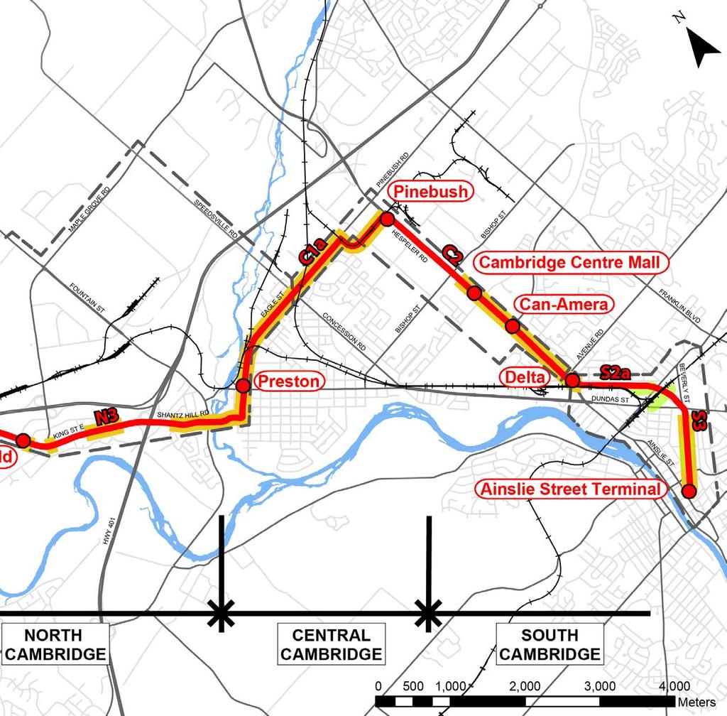
9 5.3 South Cambridge and Downtown Cambridge Terminal Why are we examining additional route alternatives? The S3 alternative was selected as the Preliminary Potential Route between Dundas Street and Downtown Cambridge. However, it was noted in the PCC No. 2 information package that further examination of alignments for S3 would be carried out, including alternatives along Beverly Street and along the former railway corridor adjacent to Mill Creek. In addition, in discussion with Grand River Transit, options for the terminus of LRT service in Downtown Cambridge have been explored. These additional alternatives have now been developed, and are presented for comment. What options are being considered? Three key alternatives have been developed between Dundas Street and Main Street, with three options for the Downtown Cambridge terminal. These options are shown in Map D-5, and include: Between Dundas Street and Main Street: Following Beverly Street in a dedicated corridor in the centre of the street (S3a) Following Beverly Street, converting Beverly Street to one-way travel for northbound vehicles, and locating LRT on one side of the street (S3b) Following the former railway alignment adjacent to Mill Creek, maintaining the multi-use pathway in a similar location (S3c), or relocating the path to the opposite side of Mill Creek (S3d) In Downtown Cambridge: On Wellington Street to the existing Ainslie Street Terminal (T1) On Wellington Street to Bruce Street, with a new terminal located near Water Street (T2) On Wellington Street to a new terminal location near Concession Road (T3) 7

10 6.0 What are the next steps? Following this PCC, the Project Team will review all feedback received. Comment sheets may be submitted until December 31, Any new information will be considered. Using input from the technical team, stakeholders and the public, the Project Team will evaluate the additional route alternatives in the Kitchener, North Cambridge and South Cambridge segments using the approved evaluation criteria (Appendix A). Based on the evaluation results a preferred route will be then identified. The Project Team anticipates presenting the findings of this evaluation at the next round of public consultation in Spring Pending the results of the evaluation and the feedback received at PCC No. 4 in spring 2018, the Project Team will bring a route recommendation to Regional Council. The overall study process is shown in Appendix B Public Consultation Feedback from the public is an important part of this project. The public consultation process provides an opportunity for the public to provide input regarding the study, and ask the Project Team questions about Stage 2 ION and about the Environmental Assessment process. Three Public Consultation Centres have been held to date, and two additional rounds of public consultation have been introduced between now and the completion of the study, as follows: The fourth public consultation opportunity will be held in spring 2018 to review the evaluation results for the additional alternatives in the Kitchener, North Cambridge and South Cambridge areas, and to confirm the Preferred Route The fifth public consultation opportunity will be held in early 2019 to present the preliminary design of the Preferred Route, including property requirements and the Business Case Following completion of the public consultation program and receipt of comments, the Project Team will compile and summarize all of the methods of public consultation from the start of the study in to an Environmental Project Report (EPR). Once complete, the EPR will be filed and made available for public review and comment for a 30-day period, following which any comments received will be addressed. 8

11 7.0 How do I stay involved? Sign-in tonight or sign-up at the website to be notified of future meetings. There will be additional PCCs held during the study. Feedback can also be provided by: Speaking with a Project Team member Submitting your thoughts via comment sheet on online Stage 2 ION documents are available at If you would like to have your name added to the project mailing list, please sign-up online at or provide your name, postal address, address and any group affiliation to: 8.0 Contact information Rapid Transit Region of Waterloo 50 Queen Street North, Suite 830 Kitchener, Ontario N2H 6P4 Phone: Fax: TTY: ION@regionofwaterloo.ca 9

12 Appendices 10
13 Appendix A Evaluation process and criteria Following confirmation of the routes to be compared in the three areas under review (Kitchener, North Cambridge, South Cambridge), the evaluation process will be undertaken. Separately within each of the three areas, the alternatives will be compared with each other, and with the previously identified Preliminary Potential Route. Category Criteria Description Transportation Social/Cultural Environment Ability to Serve Multi- Modal Nodes Impact on Traffic Operations Engineering Challenges Potential Ridership Destinations Served Properties Impacted Transit and Pedestrian Supportive Land Use Policy Cultural Heritage Impacts For example, routes in the North Cambridge area will be compared with other routes in the North Cambridge area, and with the previously identified Preliminary Potential Route (K2-N3). The evaluation criteria that will be used are the same as those used previously. The criteria are based on the Regional Official Plan community and transportation objectives and fall under four categories as shown below: Are there good opportunities for connections between LRT, Grand River Transit (GRT), and GO services, as well as Park-and-Ride lots? How many new signalized intersections are required? How many existing intersections have capacity issues and would be further impacted by LRT? How many freight rail, MTO interchange or highway crossings are there? How compatible or constrained are they? How many local transit riders use existing bus stops within 800 m of proposed LRT stops? What is the estimated LRT travel time for the segment based on length, geometry, crossings, stops, and traffic signals? Are there major commercial, industrial, office, or leisure destinations within 800 m of proposed LRT stops? How many hospitals, schools or other institutional uses are there within 800 m of the stops? How many residential, commercial, industrial or institutional properties are impacted and how many of those could potentially require full buy-out? Does the route fit with existing planning policy, such as the Provincial Growth Plan, Official Plan, Transportation Master Plan or Zoning By-Laws? How many heritage properties and buildings are there along the route? 11
14 Category Criteria Description Impact on Floodplains What area of floodplain does the route cross? Natural Environment Economic Environment Impact to Significant Natural Features Ability to Serve Concentrations of Employment Opportunity for Intensification and Revitalization Cost (Capital and Operating) Does the route cross or impact any significant natural features such as wetlands, forests, watercourses or habitat for endangered/at risk species? Will the stops provide access to existing employment areas? Is there potential for new or infill employment development within 800 m of the proposed LRT stop? Will the stops serve areas that can benefit from revitalization? Is there potential for residential intensification close to the stops? What is the estimated cost (in $2016) to design and build, then operate and maintain every year? The Project Team, which includes specialized technical and environmental experts from a variety of fields, will analyze how well each route meets the evaluation criteria objectives. The results of the analysis will be used to compare routes within segments. The analysis and draft evaluation summary will be reviewed by the Technical Advisory Committee consisting of staff and departments from the Region including Grand River Transit, as well as the Cities of Kitchener and Cambridge, Ministry of Transportation and Grand River Conservation Authority. The Project Team will also incorporate input from the Region s Senior Management Team and the Rapid Transit Steering Committee, which includes four Regional Councillors and the Regional Chair. Based on the evaluation results and the input received, the Project Team, in cooperation with the Technical Advisory Committee, will identify a route considered to be preferred for each segment. These recommendations will be presented to the public for comment at the next public consultation event, anticipated in spring Once the Preferred Route is confirmed, the Project Team will proceed with preliminary design and identify property requirements, complete the Business Case and prepare the Environmental Project Report. Another opportunity for public input on the preliminary design and property requirements will be held in early 2019, prior to finalizing the project documentation. 12

15 Appendix B Study Process Activities completed Fall 2015 Feb-Mar 2017 Early 2019 Spring 2019 Fall 2019 Develop alternative design concepts and establish evaluation criteria. Public Consultation No. 1 Evaluate alternatives and identify Preliminary Preferred Route Public Consultation No. 2 Complete preliminary design and identify property requirements Public Consultation No. 5 Present the Preferred Route and Business Case to Regional Council for endorsement File the Environmental Project Report for public review and complete the Transit Project Assessment Process Fall 2017 Spring 2018 Identify additional and refined route options based on PCC No. 2 feedback Public Consultation No. 3 Complete evaluation and present updated Preliminary Preferred Route Public Consultation No. 4 We We are here! are here! 13

16 Appendix C Preliminary Potential Route Map C-1: Preliminary Potential Route as presented at PCC No. 2 (February-March 2017) 14

17 Appendix D Route Alternative Maps Map D-1: South Kitchener Route alternative 15

18 Map D-2: North Cambridge Route suggestions 16

19 Map D-3: North Cambridge Route alternatives 17

20 Map D-4: North Cambridge Route challenges 18

21 Map D-5: South Cambridge Route alternatives 19
22 ION project website: regionofwaterloo.ca/rapidtransit Phone: ext TTY: Stage 2 website:
from Kitchener to Cambridge
 St. Jacobs Laurelwood Lakeshore NORTHFIELD to London via Stratford THE BOARDWALK Westvale Highland West Westmount WILLIS WAY Eastbridge Highland Rd W Block Line Rd Fischer-Hallman Rd Erb St W RESEARCH
CITY OF CAMBRIDGE Growth & Intensification Study Secondary Plan Stakeholder Session September 12th, 2016
 CITY OF CAMBRIDGE Growth & Intensification Study Secondary Plan Stakeholder Session September 12th, 2016 Dillon Consulting Limited Watson & Associates Economists Curtis Planning Inc. Tim Welch Consulting
Declarations of Pecuniary Interest under the Municipal Conflict Of Interest Act
 Regional Municipality of Waterloo Heritage Planning Advisory Committee Minutes February 8, 2018 5:00 PM Regional Administrative Headquarters, Room 110 150 Frederick Street, Kitchener Present were: Councilor
Appendix E: Evaluation of Network Alternatives - July 2017
 Appendix E: Evaluation of Network Alternatives - July 2017 1 Overview This Appendix provides information used in the corridor level screening and detailed corridor assessment. Corridor Level Screening:
SUBJECT: GO Station Mobility Hubs Preferred Concepts: Aldershot GO, Burlington GO and Appleby GO. Planning and Development Committee - Public Meeting
 Page 1 of Report PB-76-17 SUBJECT: GO Station Mobility Hubs Preferred Concepts: Aldershot GO, Burlington GO and Appleby GO TO: FROM: Planning and Development Committee - Public Meeting Planning and Building
SCARBOROUGH SUBWAY EXTENSION. Scarborough Subway Extension. Final Terms of Reference
 Scarborough Subway Extension Final Terms of Reference 1 1.0 Introduction and Background 1.1 Introduction Toronto City Council recently confirmed support for an extension of the Bloor-Danforth Subway from
Shift Rapid Transit Public Participation Meeting May 3, 2017
 Shift Rapid Transit Public Participation Meeting May 3, 2017 Shift Rapid Transit Initiative Largest infrastructure project in the city s history. Rapid Transit initiative will transform London s public
MAYFIELD WEST SECONDARY PLAN PHASE 2
 MAYFIELD WEST SECONDARY PLAN PHASE 2 Public Open House #3 February 25, 2010 Draft Preferred Land Use Scenario TOWN OF CALEDON PLANNING & DEVELOPMENT DEPARTMENT Open House Agenda TOWN OF CALEDON 1. Welcome
Master Environmental Servicing Plan & Secondary Plan
 1 East Side Lands Stage 2 Master Environmental Servicing Plan & Secondary Plan Public Consultation Centre #4 March 20, 2018 Welcome! Today s Agenda Please sign in at the registration table. 6:00 pm 6:30
1.0 Purpose of a Secondary Plan for the Masonville Transit Village
 Report to Planning and Environment Committee To: Chair and Members Planning & Environment Committee From: John M. Fleming Managing Director, Planning and City Planner Subject: Masonville Transit Village
1.3 TRANSIT VISION 2040 FROM VISION TO ACTION THEME 1: PUTTING TRANSIT AT THE CENTRE OF COMMUNITIES. Fully integrate transit with community planning
 TRANSIT VISION 2040 FROM VISION TO ACTION TRANSIT VISION 2040 defines a future in which public transit maximizes its contribution to quality of life with benefits that support a vibrant and equitable society,
PUBLIC OPEN HOUSE HURONTARIO-MAIN CORRIDOR SECONDARY PLAN
 PUBLIC OPEN HOUSE HURONTARIO-MAIN CORRIDOR SECONDARY PLAN Tuesday, February 28, 2012 6pm 9pm 1 st Floor Atrium, City Hall 2 Wellington Street West, Brampton 1 POLICY FRAMEWORK The 2006 Provincial Growth
Chair and Members of the Planning, Public Works and Transportation Committee. Tara Buonpensiero, Senior Planner Policy, MCIP, RPP
 REPORT TO: REPORT FROM: Chair and Members of the Planning, Public Works and Transportation Committee Tara Buonpensiero, Senior Planner Policy, MCIP, RPP DATE: April 9, 2018 REPORT NO.: RE: PLS-2018-0027
West Broadway Transit Study Initial Screening of Alternatives Memo
 West Broadway Transit Study Initial Screening of Alternatives Memo 5/22/2015 Prepared by the SRF Consulting Group Team for Table of Contents Purpose... 1 Methodology... 1 Screening... 5 Screening Criteria...
Kanata Light Rail Transit Planning and Environmental Assessment Study
 Kanata Light Rail Transit Planning and Environmental Assessment Study Public Open House #2 Transportation Services Department December 7, 2017 Agenda Review study progress Confirm the Preferred Corridor
WELCOME TO OPEN HOUSE TWO November 28, 2018
 Langstaff Road Weston Road to Highway 7 Class Environmental Assessment Study WELCOME TO OPEN HOUSE TWO November 28, 2018 Please sign in and join our mailing list Study Overview York Region is conducting
Don Mills Crossing Study and Celestica Lands Development Application Community Meeting, Open House, and Breakout Discussions
 Consultation Summary Don Mills Crossing Study and Celestica Lands Development Application Community Meeting, Open House, and Breakout Discussions This report is not intended to provide a verbatim transcript
Gold Line Bus Rapid Transit Transit Oriented Development (BRTOD) Helmo Station Area Plan
 Helmo Station Area Plan") Appendix F Gold Line Bus Rapid Transit Transit Oriented Development (BRTOD) Helmo Station Area Plan Introduction and Purpose of the Plan The Gold Line Bus Rapid Transit facility is an eleven-mile dedicated
Appendix F Gold Line Bus Rapid Transit Transit Oriented Development (BRTOD) Helmo Station Area Plan Introduction and Purpose of the Plan The Gold Line Bus Rapid Transit facility is an eleven-mile dedicated
John M. Fleming Managing Director, Planning and City Planner. Old East Village Dundas Street Corridor Secondary Plan Draft Terms of Reference
 Report to Planning and Environment Committee To: From: Subject: Chair and Members Planning & Environment Committee John M. Fleming Managing Director, Planning and City Planner Old East Village Dundas Street
Rapid Transit Implementation Working Group September 14, 2017
 Rapid Transit Implementation Working Group September 14, 2017 BACKGROUND Council approved the Rapid Transit Master Plan and Updated Business Case on July 25, 2017. Approval of the RTMP confirmed the BRT
SUBJECT: Proposed Downtown Mobility Hub Precinct Plan and Proposed Official Plan Policies
 Page 1 of Report PB-81-17 SUBJECT: Proposed Downtown Mobility Hub Precinct Plan and Proposed Official Plan Policies TO: FROM: Committee of the Whole Planning and Building Department Report Number: PB-81-17
Key Themes and Responses May 2016
 King and Victoria Transit Hub and Waterloo Street Pedestrian Access Key Themes and Responses May 2016 The following summarizes what Regional staff heard about the King Victoria Transit Hub and Waterloo
Urban Design Manual PLANNING AROUND RAPID TRANSIT STATIONS (PARTS) Introduction. Station Study Areas
 Introduction. Station Study Areas") 111111 PLANNING AROUND RAPID TRANSIT STATIONS (PARTS) Introduction The ION rapid transit system will link Waterloo, Kitchener and Cambridge through a central transit corridor (CTC). There are a number
111111 PLANNING AROUND RAPID TRANSIT STATIONS (PARTS) Introduction The ION rapid transit system will link Waterloo, Kitchener and Cambridge through a central transit corridor (CTC). There are a number
Welcome. Green Line LRT. Beltline Alignment Options. Stay engaged! Follow the Green Line story at calgary.ca/greenline
 Welcome Green Line LRT Beltline Alignment Options Stay engaged! Follow the Green Line story at calgary.ca/greenline Green Line LRT Why are we here? Our Challenge Determine the best alignment in the Beltline.
MAYFIELD WEST SECONDARY PLAN PHASE 2
 MAYFIELD WEST SECONDARY PLAN PHASE 2 Council Information Workshop February 16, 2010 Draft Preferred Land Use Plan TOWN OF CALEDON PLANNING & DEVELOPMENT DEPARTMENT Workshop Agenda TOWN OF CALEDON 1. Welcome
CITY COUNCIL AGENDA REPORT
 CITY COUNCIL AGENDA REPORT Subject: COUNCIL MOTION LRT ALIGNMENT REMOVAL FROM THE TRANSPORTATION MASTER PLAN On February 10, 2016 Councillor Hughes provided notice in accordance with Section 23 of Procedure
2 STATUTORY PUBLIC MEETING AND INFORMATION REPORT FOR PUBLIC MEETING ON AMENDMENT NO. 62 TO THE YORK REGION OFFICIAL PLAN
 2 STATUTORY PUBLIC MEETING AND INFORMATION REPORT FOR PUBLIC MEETING ON AMENDMENT NO. 62 TO THE YORK REGION OFFICIAL PLAN Pursuant to Section 17(15) of the Planning Act, as amended, the Regional Planning
Welcome. Walk Around. Talk to Us. Write Down Your Comments
 Welcome This is an information meeting introducing the applications for proposed redevelopment of the Yorkdale Shopping Centre site at 3401 Dufferin Street and 1 Yorkdale Road over the next 20+ years,
9 CITY OF VAUGHAN OFFICIAL PLAN AMENDMENT NO BOCA EAST INVESTMENTS LIMITED
 9 CITY OF VAUGHAN OFFICIAL PLAN AMENDMENT NO. 631 - BOCA EAST INVESTMENTS LIMITED The Planning and Economic Development Committee recommends the adoption of the recommendations contained in the following
NEW REGIONAL OFFICIAL PLAN HIGH LEVEL PROCESS & FRAMEWORK
 NEW REGIONAL OFFICIAL PLAN HIGH LEVEL PROCESS & FRAMEWORK Why A New Official Plan Originally the role of Regionally Planning and content of Regional Official Plan (1970s) primarily focused on protecting
NO: R035 COUNCIL DATE: FEBRUARY 24, 2014
 CORPORATE REPORT NO: R035 COUNCIL DATE: FEBRUARY 24, 2014 REGULAR COUNCIL TO: Mayor & Council DATE: February 24, 2014 FROM: General Manager, Planning and Development FILE: 6520-01 SUBJECT: Town Centre
WELCOME and introduction
 1 WELCOME and introduction Mobility Hub Locations within Burlington STUDY OVERVIEW STUDY OBJECTIVES The City of Burlington is developing four Area Specific Plans, one for each of Burlington s Mobility
Getting and Giving the Most
 Getting and Giving the Most It s OUR meeting participate enthusiastically Focus on the future Terminology expertise is secondary There is such a thing as a bad idea! Respect (for each other and the process)
Master Environmental Servicing Plan & Secondary Plan
 East Side Lands Stage 2 1 Master Environmental Servicing Plan & Secondary Plan Public Information Centre #1 June 16, 2016 Welcome! Today s Agenda Please sign in at the front desk. 5:30 pm 6:30 pm: Open
SUBJECT: Waterfront Hotel Planning Study Update TO: Planning and Development Committee FROM: Department of City Building. Recommendation: Purpose:
 Page 1 of Report PB-23-18 SUBJECT: Waterfront Hotel Planning Study Update TO: Planning and Development Committee FROM: Department of City Building Report Number: PB-23-18 Wards Affected: 2 File Numbers:
2. Shaping Waterloo Region s Urban Communities
 2. Much of the region s growth over the past several decades has occurred in suburban areas that separated where people live from where they work and shop. This pattern of growth has increased the need
Relief Line Project Assessment
 Relief Line Project Assessment Stakeholder Advisory Meeting #4 May 30, 2016 Tonight s Meeting PURPOSE To present and discuss: Results of the evaluation of potential alignments Emerging preferred alignment
Further input invited as Colchester Growth Strategy nears final phase
 IUE 3 / NOVEMBER 2015 Further input invited as Colchester Growth trategy nears final phase trathcona County is seeking public feedback as it enters the final phase of work on a Growth Management trategy
CHAIR AND MEMBERS CIVIC WORKS COMMITTEE MEETING ON JULY 17, 2017
 TO: FROM: CHAIR AND MEMBERS CIVIC WORKS COMMITTEE MEETING ON JULY 17, 2017 KELLY SCHERR, P.ENG., MBA, FEC MANAGING DIRECTOR, ENVIRONMENTAL & ENGINEERING SERVICES AND CITY ENGINEER SUBJECT: HIGH SPEED RAIL
City of Toronto. Emery Village Transportation Master Plan
 City of Toronto Emery Village Transportation Master Plan May 2009 Emery Village Transportation Master Plan Toronto, ON May 2009 Consulting Inc. 100 York Blvd., Suite 300 Richmond Hill, ON L4B 1J8 Tel:
CONSULTING SERVICES FOR THE WHITEBELT VISIONING EXERCISE ADDENDUM TO THE GTA WEST LAND USE STUDY WORK PROGRAM
 CONSULTING SERVICES FOR THE WHITEBELT VISIONING EXERCISE ADDENDUM TO THE GTA WEST LAND USE STUDY 1. Introduction WORK PROGRAM The Town of Caledon is a large, local municipality located in the Greater Toronto
38 Queen s University Campus Master Plan Part 1
 38 Queen s University Campus Master Plan Part 1 46 The Campus at the City Scale Chapter 4 The Campus at the City Scale 39 Queen s is an urban University centrally located in Kingston. Decisions made by
Mavis Road Class Environmental Assessment
 Mavis Road Class Environmental Assessment Public Information Centre #2 Wednesday November 9, 2016 6:00 to 8:00 p.m. Please sign in and complete a comment sheet Review the displays on your own or join in
Land Use Amendment in Southwood (Ward 11) at and Elbow Drive SW, LOC
 at and Elbow Drive SW, LOC") 2018 November 15 Page 1 of 10 EXECUTIVE SUMMARY This land use amendment application was submitted by Rick Balbi Architect on 2017 August 31 on behalf of Sable Developments Ltd, and with authorization from
2018 November 15 Page 1 of 10 EXECUTIVE SUMMARY This land use amendment application was submitted by Rick Balbi Architect on 2017 August 31 on behalf of Sable Developments Ltd, and with authorization from
178 Carruthers Properties Inc.
 178 Carruthers Properties Inc. Planning Rationale for 178 Carruthers Avenue Site Plan Control Application June 2014 Table of Contents 1.0 Introduction 2.0 Overview of Subject Property 3.0 Current Zoning
Atlanta BeltLine Corridor Environmental Study. Scoping Meeting August 2008
 Atlanta BeltLine Corridor Environmental Study Scoping Meeting August 2008 What Will We Be Discussing Today? Study Overview - How Did We Get Here? - What Is the Study About? - Who Is Involved? - Where Is
Mississippi Skyway Preliminary Engineering Report
 EXECUTIVE SUMMARY Mississippi Skyway Preliminary Engineering Report CITY OF RAMSEY, MINNESOTA DECEMBER 2014 City of RAMSEY EXECUTIVE SUMMARY Project Need and Intent The Mississippi Skyway pedestrian bridge
Local Growth Planning in North Central Green Line Communities
 2018 April 30 Page 1 of 6 EXECUTIVE SUMMARY This report outlines a high-level scope for local growth planning for north central Green Line communities. The catalyst for this review is the significant investments
LAND USE AMENDMENT DOWNTOWN COMMERCIAL CORE (WARD 7) MACLEOD TRAIL SE AND 5 AVENUE SE BYLAW 254D2017
 MACLEOD TRAIL SE AND 5 AVENUE SE BYLAW 254D2017") Page 1 of 10 EXECUTIVE SUMMARY This Land Use Amendment application seeks to redesignate a full downtown block (currently the YWCA site) from a Direct Control based on the CM-2 District (Land Use Bylaw
Page 1 of 10 EXECUTIVE SUMMARY This Land Use Amendment application seeks to redesignate a full downtown block (currently the YWCA site) from a Direct Control based on the CM-2 District (Land Use Bylaw
NORTH CLAYMONT AREA MASTER PLAN COMMUNITY WORKSHOP #1 FEBRUARY 3, 2016
 NORTH CLAYMONT AREA MASTER PLAN COMMUNITY WORKSHOP #1 FEBRUARY 3, 2016 1. Introduction To the team and to the Plan Planning Partners The Claymont Community WILMAPCO New Castle County Claymont Renaissance
MAIN STREET ECONOMIC DEVELOPMENT STRATEGY
 MAIN STREET ECONOMIC DEVELOPMENT STRATEGY A PATHWAY TO A BETTER POUGHKEEPSIE DRAFT Working Paper #2: Planning Strategies Submitted December 1 st, 2015 to the City of Poughkeepsie LAND USE LAW CENTER PACE
Edward R. Sajecki Commissioner of Planning and Building
 Corporate Report Clerk s Files Originator s Files CD.03.POR DATE: TO: FROM: SUBJECT: Chair and Members of Planning and Development Committee Meeting Date: February 27, 2012 Edward R. Sajecki Commissioner
3 MARKHAM NORTH-SOUTH LINK CORRIDOR PUBLIC TRANSIT IMPROVEMENTS ENVIRONMENTAL ASSESSMENT UPDATE
 3 MARKHAM NORTH-SOUTH LINK CORRIDOR PUBLIC TRANSIT IMPROVEMENTS ENVIRONMENTAL ASSESSMENT UPDATE The Rapid Transit Public/Private Partnership Steering Committee recommends the adoption of the recommendations
AGINCOURT SECONDARY PLAN
 1 AGINCOURT SECONDARY PLAN 1. AGINCOURT SECONDARY PLAN The following policies and principles apply to the area herein referred to as Agincourt, as outlined on Map 1-1. 1. GENERAL POLICIES 1.1 This Secondary
Services Department B September 10, 2007
 Report To: Development Services Committee Item: Date of Report: DS-07-246 September 5, 2007 From: Commissioner, Development File: Date of Meeting: Services Department B7200-0001 September 10, 2007 Subject:
7.4 Maintenance and Storage Facility
 Region of Waterloo Rapid Transit Project 7.4 Maintenance and Storage Facility A Maintenance and Storage Facility is required to support the LRT component of the RT system. These facilities typically include
Green Line North Centre City Alignment
 Project overview The Green Line will be an important piece of Calgary's transit network, adding 40 kilometres of track to the existing 59 kilometre LRT system. End-to-end, the line will connect North Pointe
Urban Planning and Land Use
 Urban Planning and Land Use 701 North 7 th Street, Room 423 Phone: (913) 573-5750 Kansas City, Kansas 66101 Fax: (913) 573-5796 Email: planninginfo@wycokck.org www.wycokck.org/planning To: From: City Planning
Official Plan Review
 Official Plan Review Summary Report - The Built Environment August 2014 Part 1: Introduction Planning for a healthy, prosperous and sustainable community is an important goal for our municipality. From
CHAPTER 7: Transportation, Mobility and Circulation
 AGLE AREA COMMUNITY Plan CHAPTER 7 CHAPTER 7: Transportation, Mobility and Circulation Transportation, Mobility and Circulation The purpose of the Transportation, Mobility and Circulation Chapter is to
Northwest LRT Downtown to. Northwest Edmonton Study. Public Workshops
 Northwest LRT Downtown to Northwest Edmonton Study Public Workshops March 23 & 24, 2010 Welcome Thank you all for attending Welcome Introductions Welcome Our Team s Commitment to You for Tonight To provide
1071 King Street West Zoning Amendment Application - Preliminary Report
 STAFF REPORT ACTION REQUIRED 1071 King Street West Zoning Amendment Application - Preliminary Report Date: August 9, 2012 To: From: Wards: Reference Number: Toronto and East York Community Council Director,
Seattle Transit Master Plan
 Seattle Transit Master Plan Seattle City Council Transportation Committee Briefing May 10, 2011 Seattle Department of Transportation Presentation Outline Review of project schedule and goals Review of
CDAC. Update: Downtown Dartmouth Update: CDAC July 25 th Motion
 CDAC Update: Downtown Dartmouth Update: CDAC July 25 th Motion 2018-10-24 Downtown Dartmouth Plan Open House October 22, 2018 6:00 pm Open House 6:30 pm Presentation + Q&A 7:20 pm Open House 8:30 pm Close
RESOLUTION NO. R Refining the route, profile and stations for the Downtown Redmond Link Extension
 RESOLUTION NO. R2018-32 Refining the route, profile and stations for the Downtown Redmond Link Extension MEETING: DATE: TYPE OF ACTION: STAFF CONTACT: Capital Committee Board PROPOSED ACTION 09/13/2018
SAN RAFAEL GENERAL PLAN 2040 INTRODUCTION AND OVERVIEW
 SAN RAFAEL GENERAL PLAN 2040 INTRODUCTION AND OVERVIEW Steering Committee Presentation February 14, 2018 Purpose of General Plan Guide land use and development decisions Coordinate transportation, infrastructure,
Portage Parkway Environmental Assessment Public Information Centre No. 1
 City of Vaughan Portage Parkway Environmental Assessment Public Information Centre No. 1 November 25, 2015 Welcome to the Public Information Centre This first Public Information Centre (PIC) introduces
Welcome to Our Open House
 Welcome to Our Councillor Gerbasi & the Planning, Property, & Development Department welcome you to tonight s open house The open house outlines the proposed Osborne Village Neighbourhood Plan a secondary
Figure 1- Site Plan Concept
 Figure 1- Site Plan Concept Parking will be provided underground on three levels at rate of 1.0 space/ unit; this rate includes all visitors parking. MMM Group has prepared a parking assessment (April,
New Partners for Smart Growth Conference February 5, 2010
 Dan Stroh, Planning Director City of Bellevue Planning and Community Development Bellevue, WA New Partners for Smart Growth Conference February 5, 2010 Summary of Project Long-range plan update for Bel-Red
Public Information Centre #1
 and Highway 401 Interchange Improvements WELCOME Public Information Centre #1 Veterans Memorial Parkway Extension and Highway 401 Interchange Improvements Study May 23, 2012 4 p.m. to 7 p.m. Brief Overview
1.4 TRANSIT VISION 2040 FROM VISION TO ACTION THEME 1: PUTTING TRANSIT AT THE CENTRE OF COMMUNITIES. Fully integrate transit with community design
 TRANSIT VISION 2040 FROM VISION TO ACTION TRANSIT VISION 2040 defines a future in which public transit maximizes its contribution to quality of life with benefits that support a vibrant and equitable society,
Introduction. Public Information Package. Project website. Overview. Class Environmental Assessment Process
 1 Introduction Public Information Package Baseline Road Extension between Lambs Road and Bennett Road, Bowmanville Schedule B Municipal Class Environmental Assessment November 6, 2017 Overview The purpose
Welcome to the Oakridge Centre Open House
 Welcome to the Oakridge Centre Open House Why is the City hosting this event? This open house is to inform you of a rezoning application submitted to the City of Vancouver to amend the existing CD-1 (Comprehensive
PART 1. Background to the Study. Avenue Study. The Danforth
 The Danforth 1.1/ Study Purpose & Key Municipal Goals 1.2/ The Local Advisory Committee 1.3/ The Project Team 1.4/ Study Process/Summary of Method 1.5/ Summary of Consultation 1.1 Study Purpose and Key
Contact: Alex Taranu ( ) or Karl Walsh ( )
 or Karl Walsh ( )") Date: 09 September 2005 File: Subject: P03.DUDS Downtown Urban Design Vision Study Report Contact: Alex Taranu (905 874 3454) or Karl Walsh (905 874 2331) OVERVIEW Staff has produced an Urban Design Vision
Date: 09 September 2005 File: Subject: P03.DUDS Downtown Urban Design Vision Study Report Contact: Alex Taranu (905 874 3454) or Karl Walsh (905 874 2331) OVERVIEW Staff has produced an Urban Design Vision
VILLAGE OF BOLTON HERITAGE CONSERVATION DISTRICT PLAN
 Page 1 1. INTRODUCTION AND BACKGROUND 1.1 THE PROJECT VILLAGE OF BOLTON HERITAGE CONSERVATION DISTRICT PLAN TERMS OF REFERENCE The Town of Caledon (Town) is a large, predominantly rural municipality with
3. Endorse the LRT vision in transforming Surrey into Connected-Complete-Livable communities, and more specifically, the official vision statement:
 CORPORATE REPORT NO: R038 COUNCIL DATE: February 20, 2017 REGULAR COUNCIL TO: Mayor & Council DATE: February 16, 2017 FROM: General Manager, Engineering FILE: 8740-01 SUBJECT: Surrey Light Rail Transit
Summary of Changes for the Comprehensive Draft Proposed Official Plan Amendment
 Summary of Changes for the Comprehensive Draft Proposed Official Plan Amendment Note: Due to the broad scope of the Official Plan Review, this list is not exhaustive of the extent of changes in the comprehensive
HURON COMMUNITY PLAN
 CITY OF KITCHENER DEPARTMENT OF DEVELOPMENT AND TECHNICAL SERVICES PD 94/7 HURON COMMUNITY PLAN Recommended by Planning and Economic Development Committee: October 31, 1994 Adopted by Kitchener City Council:
13 THORNHILL YONGE STREET STUDY IMPLEMENTATION CITY OF VAUGHAN OPA 669 AND TOWN OF MARKHAM OPA 154
 13 THORNHILL YONGE STREET STUDY IMPLEMENTATION CITY OF VAUGHAN OPA 669 AND TOWN OF MARKHAM OPA 154 The Planning and Economic Development Committee recommends the adoption of the recommendations contained
TRANSIT-ORIENTED DEVELOPMENT POLICY DRAFT. City Planning and Development Department Kansas City, Missouri
 TRANSIT-ORIENTED DEVELOPMENT POLICY DRAFT City Planning and Development Department Kansas City, Missouri What is Transit Oriented Development (TOD)? Development that focuses land uses around a transit
Report to: Development Services Committee Report Date: September 11, 2017
 ~RKHAM Report to: Development Services Committee Report Date: September 11, 2017 SUBJECT: PREPARED BY: Conceptual Master Plan for the Future Urban Area - Community Structure Plan and Key Policy Direction
Planning for the Future Urban Area. in north Markham. Update. Development Services Committee. December 9, De Development Services Committee
 Planning for the in north Markham 1 Update De December 9, 2014 Overview - Growth Management Strategy and new Official Plan 2014 Status - Official Plan 2014 and ROPA3 Update - Planning for the Future Urban
2.0 A FRAMEWORK FOR SUSTAINABLE GROWTH CONTENTS
 2-2 A Framework for Sustainable Growth 2.0 A FRAMEWORK FOR SUSTAINABLE GROWTH CONTENTS 2.1 MANAGING SUSTAINABLE GROWTH THE VISION TO 2031 2.2 GOALS AND OBJECTIVES 2.2.1 Protecting the Natural Environment
Public Open House. Overview of the Downtown Plan Official Plan Amendment April 23, 2018
 Public Open House Overview of the Downtown Plan Official Plan Amendment April 23, 2018 1 A 25-Year Plan for Downtown To ensure growth contributes positively to Toronto s Downtown as a great place to live,
CONTENTS 2.0 A FRAMEWORK FOR SUSTAINABLE GROWTH 2.1 MANAGING SUSTAINABLE GROWTH THE VISION TO GOALS AND OBJECTIVES 2.3 MARKHAM STRUCTURE
 2 A Framework for Sustainable Growth 2.0 A FRAMEWORK FOR SUSTAINABLE GROWTH CONTENTS 2.1 MANAGING SUSTAINABLE GROWTH THE VISION TO 2031 2.2 GOALS AND OBJECTIVES 2.2.1 Protecting the Natural Environment
THE CORPORATION OF THE TOWN OF OAKVILLE BY-LAW NUMBER
 THE CORPORATION OF THE TOWN OF OAKVILLE BY-LAW NUMBER 2017-120 A by-law to adopt an amendment to the Livable Oakville Plan, Official Plan Amendment Number 20 (Downtown Oakville Growth Area) WHEREAS the
City of Kingston. North King s Town Secondary Plan Open House + Workshop #1 February 28, 2018
 City of Kingston North King s Town Secondary Plan Open House + Workshop #1 February 28, 2018 1 event agenda 30 min Panel Review + Discussion 30 min Presentation + Q&A 75 min Workshop Session 15 min Report
TOWN OF WHITBY REPORT RECOMMENDATION REPORT
 TOWN OF WHITBY REPORT RECOMMENDATION REPORT REPORT TO: Council REPORT NO: PL 95-09 DATE OF MEETING: October 13, 2009 PREPARED BY: Planning/Public Works Joint Report FILE NO(S): N/A LOCATION: N/A REPORT
Coordinated Transit Planning in Toronto SmartTrack GO RER Scarborough Relief Line Waterfront Transit
 Coordinated Transit Planning in Toronto SmartTrack GO RER Scarborough Relief Line Waterfront Transit Public Information Centres February 2016 Transportation Planning Section City Planning Division Toronto
The Illinois Department of Transportation and Lake County Division of Transportation. Route 173, including the Millburn Bypass
 The Illinois Department of Transportation and Lake County Division of Transportation welcome you to this Public Hearing for U.S. Route 45 from Illinois Route 132 to Illinois Route 173, including the Millburn
Second Line West Pedestrian/Cyclist Crossing of Highway 401 Class EA. Second Line West Pedestrian/Cyclist Crossing of Highway 401 Class EA
 1 1 Purpose of Public Information Centre #2 To provide interested and/or potentially affected stakeholders with an opportunity to participate in the planning and decision-making process for this Municipal
St. Clair Avenue West Area Transportation Master Plan
 1 (Between Keele Street and Old Weston Road) Public Information Centre 1 December 2, 2015 2 Welcome Welcome to the first Public Information Centre for the St. Clair Avenue West Area. The panels will present
EXHIBIT A. Tax Increment Reinvestment Zone No. 1 (Town Center) First Amended Project Plan 1
 First Amended Project Plan 1") EXHIBIT A Tax Increment Reinvestment Zone No. 1 (Town Center) First Amended Project Plan 1 1 As amended by Resolution No. 2008-02-001(TR1R) of the Tax Increment Reinvestment Zone No.1, and approved to
EXHIBIT A Tax Increment Reinvestment Zone No. 1 (Town Center) First Amended Project Plan 1 1 As amended by Resolution No. 2008-02-001(TR1R) of the Tax Increment Reinvestment Zone No.1, and approved to
Former Rockcliffe Airbase Community Design Plan Guiding Design Vision and Principles December 4, 2013
 APPENDIX 5 - Guiding Design Vision and Principles Former Rockcliffe Airbase Community Design Plan Guiding Design Vision and Principles December 4, 2013 Vision Statement The redevelopment of the former
Transportation Committee
 Transportation Committee Business Item No. 2013-286SW Meeting date: October 14, 2013 For the Metropolitan Council meeting of October 16, 2013 Subject: Southwest Light Rail Transit (Green Line Extension):
Plan Overview. Manhattan Area 2035 Reflections and Progress. Chapter 1: Introduction. Background
 Plan Overview The Manhattan Urban Area Comprehensive Plan (the Comprehensive Plan) is a joint planning initiative of the City of Manhattan, Pottawatomie County, and Riley County. The 2014 Comprehensive
CITY OF VAUGHAN EXTRACT FROM COUNCIL MEETING MINUTES OF NOVEMBER 15, 2016
 Item 11, Report No. 38, of the Committee of the Whole, which was adopted without amendment by the Council of the City of Vaughan on November 15, 2016. Regional Councillor Di Biase declared an interest
This Review Is Divided Into Two Phases:
 Semiahmoo Town Centre Review The purpose of this review: To review the Semiahmoo Town Centre Concept Plan, originally approved in 1993, to ensure that this centre will continue to serve the needs of South