Lincoln Multi-Modal Center
|
|
|
- Mervyn Cannon
- 5 years ago
- Views:
Transcription
. Theses from the Architecture Program. 28.")
1 University of Nebraska - Lincoln DigitalCommons@University of Nebraska - Lincoln Theses from the Architecture Program Architecture Program May 2006 Lincoln Multi-Modal Center Jeffrey Bayer Follow this and additional works at: Part of the Architecture Commons Bayer, Jeffrey, "Lincoln Multi-Modal Center" (2006). Theses from the Architecture Program This Article is brought to you for free and open access by the Architecture Program at DigitalCommons@University of Nebraska - Lincoln. It has been accepted for inclusion in Theses from the Architecture Program by an authorized administrator of DigitalCommons@University of Nebraska - Lincoln.
2 Lincoln Multi-Modal Center by Jeffrey Bayer A Terminal Project Presented to the Faculty of The College of Architecture at the University of Nebraska In Partial Fulfillment of Requirements For the Degree of Master of Architecture Major: Architecture Under the Supervision of Professor Thomas Laging Lincoln, Nebraska May, 2006 Lincoln Nebraska 1
3 Project Abstract The problem with many cities today is the lack of transportation options. Our society believes and enforces that the only way to get somewhere is by car. Mass transit is seen as dirty and bad, and we are just too lazy to walk. It is also next to impossible to walk from place to place most of the city; everything is just too far apart. This is the case when cities are made of suburbs and big box developments. The ability to implement an alternative transit system is severely inhibited by this style of development. The urban core, or downtown of these cities are still alive and in many cases showing new signs of life. The real problem lies with how to connect people to this core and how to connect these cores together. There needs to be central node for multiple systems to converge and feed the city. The density of these downtown areas creates a perfect place to locate such a node. One day Lincoln will need a multi-modal transportation system. The streets and cars cannot support Lincoln or any city forever. The creation of a transit system can help drive transit oriented development. At the center of this system, or systems, will be a center that will allow people to transfer from one system to another. A person could travel from south Lincoln to the multi-modal center and then transfer onto a large system that will take them to another city such as Omaha. This center will help downtown Lincoln grow stronger by providing a destination that connects the urban core of Lincoln to its surroundings. Along with downtown Lincoln growing stops along the new transportation corridors will grow because of these new influences. 2 Multi-Modal Center
4 Table of Contents Research/Analysis Conceptual Design Process Documentation Final Design Documentation Bibliography Lincoln Nebraska 3

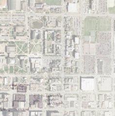
5 Research/Analysis Downtown Lincoln 4 Multi-Modal Center


6 Streets and Rails Waterways and Greenspaces The stream beds, indicated in blue, run through the entire city influencing growth. Green spaces are closely related to the stream beds, most being located next to the waterway. Eastern downtown will be affected greatly by the antelope valley. It will create a strong barrier along with providing new green space. This will hopefully bring life into the eastside. This also shows the major roadways through Lincoln along with the current in use rail right of ways. These paths were influenced by the waterways in many parts of Lincoln. The rail creates a definite boundary for the west side of downtown. The result is the rail takes up a lot of space and creates unpleasant sites. Lincoln Nebraska 5


7 Research/Analysis Districts - Campus - Commercial - Haymarket 6 The downtown of Lincoln is made up of three major districts; UNL campus, the Haymarket, and the commercial district. UNL creates the northern section of downtown providing a large source of people for most of the year. UNL is connected to the commercial district through a row of blocks that are part of each district. Downtown consists of mainly commercial, but also provides some retail, eating and a growing residential market. The office buildings in this district create poor street life because of the dead office street fronts and parking garages that take up most of area. Poor building design and lack of mixed use creates this problem. Separated from the other two districts is the Haymarket. This historical Haymarket district is an attraction in itself. The area provides eating, small retail shops, and some residential. The Haymarket currently has potential growth around it that can create a major influence of the rest of downtown. The growth of the Haymarket district to the west will create major attractions and to the south new residential. Multi-Modal Center


8 Major and Minor Roads Ost I-180 Ost Lst Downtown currently has three major streets running through it. Once the antelope valley project is finished 19th street will become another major two way through street. Even though O Street is a major street it still can have pedestrian life without much change. 9th and 10th streets divide the Haymarket from the rest of downtown, because they are one way and are six lanes wide. If the Haymarket district expands the division that 9th and 10th streets create will have to be overcome. This problem can be solved multiple ways all of which have their pros and cons. There are a number of minor and pedestrian streets. The Haymarket consist of good pedestrian streets that should not be change greatly. However places like the centennial mall and where it has been turned to streets is neither a good street for cars nor pedestrians. P and Q streets are good pedestrian streets because of what is located on it, they might be better served if they became two way streets. 9th 10th 19th Kst Lincoln Nebraska 7


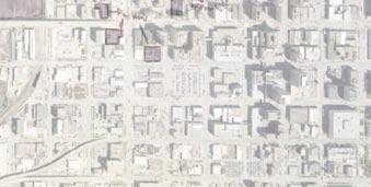
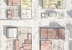
9 Research/Analysis Building Footprints The footprints show how dense downtown is running from the Haymarket to the capital area. This area has slowly filled in the empty space to create a semi dense urban core. The streets are however not always the best places to be. There may be a lot of people in the area but they are kept off of the street do to poor building and street design. Many of the buildings are single use office buildings and are only active during the work day when people are coming and going. The mass of buildings become broken up towards the edges of downtown. The areas here are broken and not pedestrian friendly. 8 Multi-Modal Center


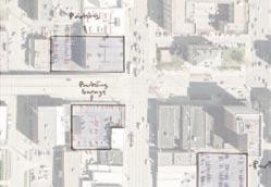
10 Parking Garages Parking garages take place of the surface parking in the core downtown. However too many garages are not design well or with a mixed use in mind. A few that have other uses built into them have created and very friendly street front. Others are very cold and have dead street fronts. Parking garages are a good replacement for the surface parking as long as the keep the street front alive and do not take over downtown, if alternate modes of transportation are not provided to downtown garages can take over. Lincoln Nebraska 9


11 Research/Analysis Surface Parking Surface parking does not control the core of downtown, but starts to take over towards the edges. These parking lots divide the blocks up and create very unfriendly pedestrian places. These areas would serve the area much better under a different use. The southern part of the Haymarket, south of O Street has a lot of potential spaces to fill in and create a new part of downtown. Surface parking in the southern part of downtown creates a division between the residential and the commercial areas. The eastern blocks of downtown create the same problem. 10 Multi-Modal Center


12 Greenspaces Most of the green space in downtown is contained in UNL campus. This is public space but is concentrated in the northern part of downtown. There is very little green space in the rest of downtown. Centennial Mall was great north south connection of green space; because it was not very well designed and it is not considered a good space, it is also slowly being taken away from the city. The mall is just becoming another street. There is a potential with the centennial mall again if it is design well. In the new development of the southern Haymarket there could be good opportunities for new green space. Lincoln Nebraska 11


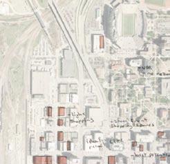
13 Research/Analysis Pedestrian Densities The two densest areas of people are outside the student union and around 14th and O Street. The Haymarket also has a good amount of people and the potential to attract more. This area is a key part of downtown and will become bigger. The Student Union on UNL campus is very dense area of downtown. This area is the densest during the school year and during mid day. It also provides a good source of people for the rest of downtown to feed on. The commercial area of downtown around 14th and O Street is the densest of downtown. There is about a four block area to the north and west of there that is the center of most pedestrian activity. These three areas create the core of downtown Lincoln pedestrian life and could be stronger with some connectivity. 12 Multi-Modal Center


14 Walking Distances These circles are created by how far a person could walk in a five to ten minutes time period. Most of downtown can be reached from the three different pedestrian areas. These circles meet showing an approximant central node of downtown pedestrian activity, a central area from which downtown can grow, a place to anchor the three areas together. Something in this central area can feed the rest of downtown. Lincoln Nebraska 13


15 Research/Analysis Pedestrian Streets The main streets that are pedestrian friendly are shown here are contained within the five to ten minutes circles. These streets have the most life on them and have the most potential of growth around them. The streets of campus connect with the streets of downtown but the Haymarket is cut off. To help these areas grow the 9th and 10th street barriers have to be dealt with. All of these pedestrian streets can grow and link downtown together with well design blocks and streets. Good planning can create a walkable place that can promote a better transit system. 14 Multi-Modal Center

16 Potential Developement Lincoln Nebraska 15
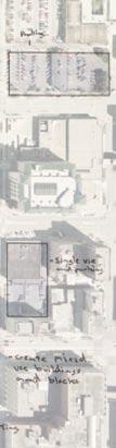
17 Research/Analysis Retail 16 Multi-Modal Center


18 Eating and Drinking Lincoln Nebraska 17
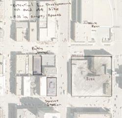
19 Research/Analysis Potential Development 18 Multi-Modal Center
20 Pedestrian vs Cars Lincoln Nebraska 19
21 Research/Analysis Active Street Fronts 20 Multi-Modal Center


22 Building Types Lincoln Nebraska 21
23 Research/Analysis Possible Alternative Transit 22 Multi-Modal Center


24 Urban Square Lincoln Nebraska 23
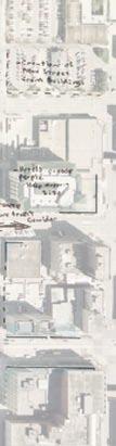
25 Research/Analysis Surrounding Elevations 24 Multi-Modal Center
26 Lincoln Nebraska 25


27 Research/Analysis Transportation Technology There are many types of transportation systems available. Newer systems will allow cities better options to move people quickly from on place to another. Trains that use technology such as monorail and maglev will allow for faster transportation with better asthetics than a tradition train and rail system. Updated bus, street car, and light rail systems could all be used to provide alternative transportation options. 26 Multi-Modal Center


28 Sky Web Sky Web is a new type of Personal Rapid Transit. This system will allow people to choose their destination and bypass others stations. It allows more flexibility than a traditional transportation system. Lincoln Nebraska 27


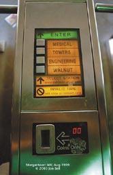
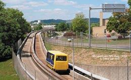
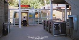
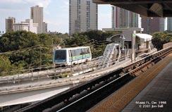
29 Research/Analysis Morgantown, West Virginia The transportation system that serves the University of West Virginia is one of the only Personal Rapid Transit systems in the country. It allows the users to choose their destination and not rely on a time based transportation system. 28 Multi-Modal Center
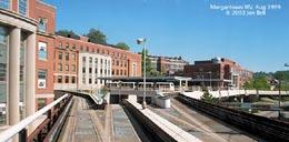
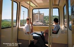
30 Morgantown, West Virginia Lincoln Nebraska 29
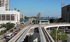
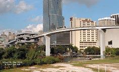

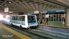
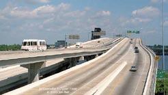
31 Research/Analysis Miami, Florida: The Metromover 30 Multi-Modal Center


")


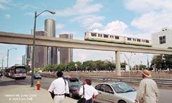
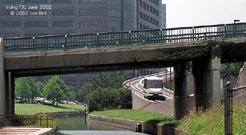
32 Detroit, Michigan: Downtown People Mover (DPM) Lincoln Nebraska 31
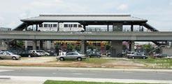
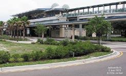
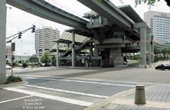
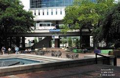
33 Research/Analysis Jacksonville, Florida: The Skyway 32 Multi-Modal Center


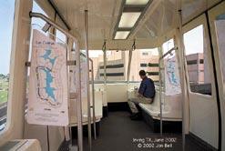
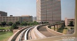
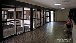
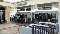
34 Irving, Texas: Las Colinas Peoplemover (APT) Lincoln Nebraska 33

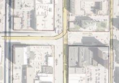
35 Research/Analysis Exsisting Transportation Types of Transit Red - Cars Green - Pedestrian Brown - Buses Ost 9th 10th 9th 10th Ost 34 Multi-Modal Center


36 Future Transportation Types of Transit Red - Cars Green - Pedestrian Brown - Buses Purple - Train Blue - Street Car Yellow - Personal Rapid Transit Lincoln Nebraska 35


37 Research/Analysis Present and Future Types of Transit Red - Cars Green - Pedestrian Brown - Buses Purple - Train Blue - Street Car Yellow - Personal Rapid Transit Existing Buildings and Transit Future Buildings and Transit 36 Multi-Modal Center


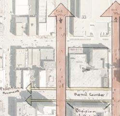
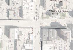
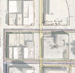
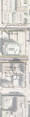
38 Site Transportation Types of Transit Red - Cars Green - Pedestrian Brown - Buses Purple - Train Blue - Street Car Yellow - Personal Rapid Transit Lincoln Nebraska 37


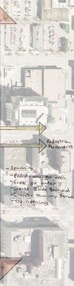
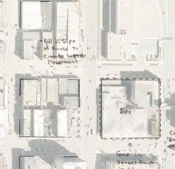
39 Conceptual Design Site Movement Diagrams Study of movement around buildings site and through site. 38 Multi-Modal Center

40 Spacial Diagrams Study of space and possible urban connections of site and surroundings. Lincoln Nebraska 39
41 Conceptual Design Spacial Diagrams Early study of building spaces and relationship to site and transportation. 40 Multi-Modal Center


42 Spacial Diagrams Early plan concepts and spacial designs. Lincoln Nebraska 41
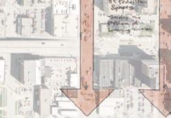
43 Design Documentation Pedestrian Bridge Diagrams Study of pedestriant bridge concepts and how it will affect pedestrian movement accross 9th street. 9th 42 Multi-Modal Center


44 Main Entrance Sketches Concepts of main entry to lower levels of building. A space that will allow people to gather in and shops and restaurants to spill out onto. Lincoln Nebraska 43


45 Design Documentation Street Front Sketches Concepts of street front and how the building and transit track affect the pedestrians on the sidewalk. 44 Multi-Modal Center


46 Trains Station Sketches Lincoln Nebraska 45
47 Design Documentation Initial Plans and Elevation Tower Second Garage Third Ground Garage 46 Multi-Modal Center
48 Initial Sections Lincoln Nebraska 47
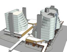
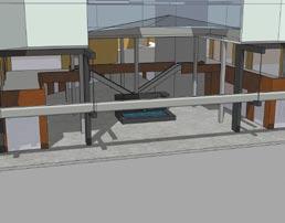
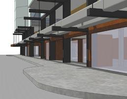
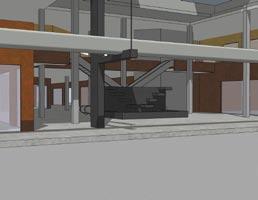
49 Design Documentation Early 3D Modal 48 Multi-Modal Center

50 Early 3D Modal Lincoln Nebraska 49

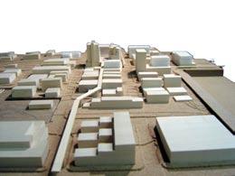
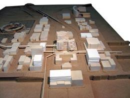
51 Final Design Documentation Site Model 50 Multi-Modal Center


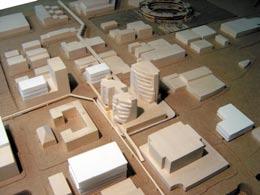
52 Site Model Lincoln Nebraska 51

53 Final Design Documentation 52 Multi-Modal Center

54 Lincoln Nebraska 53
55 Final Design Documentation 54 Multi-Modal Center

56 Lincoln Nebraska 55
57 Final Design Documentation 56 Multi-Modal Center

58 Lincoln Nebraska 57

59 Final Design Documentation 58 Multi-Modal Center

60 Lincoln Nebraska 59

61 Final Design Documentation 60 Multi-Modal Center

62 Lincoln Nebraska 61

63 Final Design Documentation 62 Multi-Modal Center

64 Final Design Documentation Lincoln Nebraska 63

65 Final Design Documentation 64 Multi-Modal Center

66 Lincoln Nebraska 65

67 Final Design Documentation 66 Multi-Modal Center

68 Lincoln Nebraska 67

69 Final Design Documentation 68 Multi-Modal Center

70 Lincoln Nebraska 69

71 Final Design Documentation 70 Multi-Modal Center

72 Lincoln Nebraska 71

73 Final Design Documentation 72 Multi-Modal Center

74 Lincoln Nebraska 73
75 Program Transit Train: Raised modern train system (maglev/monorail) Serves City to City and airports (Lincoln/Omaha) Personal Rapid Transit: 3-4 person cars Serves City of Lincoln Bus: City Bus Serves City of Lincoln Retail/Restaurant: sqft Office: sqft Apartments: sqft 47 units, 900 sqft to 2000 sqft Parking: 350 stalls under ground garage Street Meter Parking 74 Multi-Modal Center
76 Bibliography Morgantown, West Virginia Personal Rapid Transit (PRT) Miami, Florida: The Metromover Jacksonville, Florida: The Skyway Irving, Texas: Las Colinas Peoplemover (APT) Detroit, Michigan: Downtown People Mover (DPM) Lincoln, Nebraska ftp://gisftp.ci.lincoln.ne.us/../download/ Transportation Technology Garven, Alexander. The American City, What Works, What Doesn t New York, McGraw-Hill 2002 p Lincoln Nebraska 75
The Urban Core: Downtown Lincoln
 The 'P' Street corridor linking The Urban Core: Downtown Lincoln the Haymarket District to the Antelope Valley Parkway is a place of many possibilities. What are the conditions & attributes that will successfully
The Boomburb Downtown. Robert Lang, Ph.D. Arthur C. Nelson, Ph.D. FAICP Metropolitan Institute at Virginia Tech
 The Boomburb Downtown Robert Lang, Ph.D. Arthur C. Nelson, Ph.D. FAICP Metropolitan Institute at Virginia Tech Boomburbs Have over 100,000 residents and are mostly found in the Southwest U.S. Are not the
Seneca Meadows. Block 4 Locate office, technology, and medical development adjacent to I Screen views of garage structures from I-270.
 Seneca Meadows Seneca Meadows has an industrial park in its southern end and a mixed-use employment area planned for the north end. The district benefits from extensive I-270 visibility, stream valley
Eastern Terminus TECHNICAL MEMORANDUM CENTRAL BROWARD EAST-WEST TRANSIT ANALYSIS BROWARD COUNTY, FLORIDA
 Eastern Terminus TECHNICAL MEMORANDUM CENTRAL BROWARD EAST-WEST TRANSIT ANALYSIS BROWARD COUNTY, FLORIDA FINANCIAL PROJECT ID NUMBER 411189-2-22-01 FLORIDA DEPARTMENT OF TRANSPORTATION DISTRICT 4 Prepared
Sustainable Development Call for Projects
 Sustainable Development Call for Projects 2005-2006 Infrastructure Project Examples *Note: This list is not all inclusive, but a sampling of the types of projects that were awarded funds. 137 Projects
Urban Core Center, Downtown Lincoln
 Downtowns across America had a rough go over the last half of the 20 th century as the lifeblood of the urban core was drained away into the surburban realm. Fortunately, many towns and cities are rediscovering
Lynn Housing Authority and Neighborhood Development. Washington Street Gateway District Plan A p r i l
 Lynn Housing Authority and Neighborhood Development Washington Street Gateway District Plan A p r i l 2 0 0 8 rendering of sagamore hill from lynnway pedestrian overpass table of contents project area
ELMVALE ACRES SHOPPING CENTRE MASTER PLAN
 ELMVALE ACRES SHOPPING CENTRE MASTER PLAN Contents 1.0 INTRODUCTION... 2 2.0 LOCATION... 2 3.0 EXISTING CONTEXT... 2 4.0 VISION & GUIDING PRINCIPLES... 2 5.0 LAND USE AND BUILT FORM... 4 5.1 St. Laurent
Regency Developments. Urban Design Brief. Holyrood DC2 Rezoning
 Regency Developments Urban Design Brief Holyrood DC2 Rezoning Stantec Consulting Ltd. 7-31-2017 1. Overview Regency Developments intends to rezone the lands located at 8510 and 8511 93 Avenue, within the
DOWNTOWN JACKSONVILLE MASTER PLAN S T R E E T H I E R A R C H Y
 DOWNTOWN JACKSONVILLE MASTER PLAN S T R E E T H I E R A R C H Y Gateway Intra-District Business Inter-District 44 CELEBRATING THE RIVER: A PLAN FOR DOWNTOWN JACKSONVILLE The Transportation Network This
11.0 TRANSPORTATION ELEMENT
 11.0 TRANSPORTATION ELEMENT Transit, Circulation and Parking Sub-Element: For all campuses, FIU's goal is to increase multimodal access. In combination with other measures - such as the development of
The transportation system in a community is an
 7 TRANSPORTATION The transportation system in a community is an important factor contributing to the quality of life of the residents. Without a sound transportation system to bring both goods and patrons
Metro. Activity Center Design Guidelines. Recommendations For Developing Focused, Mixed-Use Commercial/Residential Centers
 Metro Activity Center Design Guidelines Recommendations For Developing Focused, Mixed-Use Commercial/Residential Centers Metro Activity Centers What is a MAC? Legacy, the adopted guide for the future growth
SOUTH FLORIDA TOD GRANT UPDATE
 Palm Beach Transportation Planning Agency October 2018 SOUTH FLORIDA TOD GRANT UPDATE Presented by Treasure Coast Regional Planning Council in partnership with SFRTA & SFRPC What is Transit Oriented Development
MALL REVITALIZATION CASE STUDIES
 MALL REVITALIZATION CASE STUDIES DECEMBER 9, 2012 MALL REVITALIZATION OVERVIEW Introduction Sample Case Studies prepared for Lacey Woodland District Steering Committee as it considers strategies to revitalize
Planning Districts INTRODUCTION
 INTRODUCTION To facilitate detailed examination of development prospects for all areas of the community, Delano has been divided into 14 planning districts. The location of these planning districts is
Bus Rapid Transit Backgrounder. December 2016
 Bus Rapid Transit Backgrounder December 2016 Background The City of London is completing the second stage of Shift, its public transit planning exercise. Shift, focuses on rapid transit, along with vehicular
THE NEIGHBORHOOD TODAY
 THE NEIGHBORHOOD TODAY CORE AREA VISION How are we Good Urbanism A Site s DNA thinking about Elements of great Unique elements urban communities embedded in a place the site and design? ELEMENTS LIKE:
Establish a network of streetscaped vehicle and pedestrian routes that connect within and outside the Plan area.
 This Plan s urban design goals are to create an urban scale, walkable community with connections to transit, parks, and services and with amenities and facilities for residents and employees. The 1992
The Need to Develop a Transit Ready Community
 Evaluation & Appraisal Report (EAR) Major Issue # 6 The Need to Develop a Transit Ready Community July 3, 2007 EAR Major Issue # 6 Transit Ready Existing Comp Plan policies apply only to Indiantown Road:
CHARLES PUTMAN CHARLES PUTMAN AND ASSOCIATES, INC
 MEMORANDUM CHARLES PUTMAN & ASSOCIATES, INC. LAND DEVELOPMENT CONSULTANTS PLANNING ZONING PERMITTING 4722 NW Boca Raton Boulevard, Suite C-106 Boca Raton, Florida 33431 Phone: 561/994-6411 FAX: 561/994-0447
A P P E N D I X B - O P P O R T U N I T Y S I T E S
 A P P E N D I X B - O P P O R T U N I T Y S I T E S OPPORTUNITY SITES As listed in the Land Use Element, the City has identified 15 Opportunity Sites expected to be the focus of change and revitalization
Town Center. Block 5 Existing multifamily residential units are expected to remain.
 Area Guidelines Germantown s districts should be developed as distinct communities with unique features that are supported through the guidelines. The guidelines not only help distinguish these districts
Prosperity Hucks Area Plan. Transportation and Planning Committee May 11, 2015
 Prosperity Hucks Area Plan Transportation and Planning Committee May 11, 2015 Presentation Outline 1. Background and Location 2. Community Dialog Process 3. Activity Center Recommendations 4. Wedge Recommendations
MURRAY CENTRAL STATION MASTER PLAN Central Station Area of Influence and Site Analysis
 CENTRAL STATION MASTER PLAN Central Station Area of Influence and Site Analysis OVERVIEW Planned Fire Station TAYLORSVILLE A thorough Site Analysis was conducted to ensure planning and design concepts
Subarea 5 Southern Gateway. Vision. Mobility The proposed street network will create developable blocks that are scaled appropriately for the area.
 southern gateway 194 Southern Gateway extends south of I-435 to 123 rd Street and includes the area past the Blue Valley Parkway division. This area is adjacent to major office centers such as the College
SYRINGA VALLEY SPECIFIC PLAN NARRATIVE
 SYRINGA VALLEY SPECIFIC PLAN NARRATIVE Introduction With this application, Pleasant Valley South LLC ( Pleasant Valley ) seeks the City of Boise s approval of a new Specific Plan Ordinance to be added
LOS ANGELES MISSION COLLEGE MASTER PLAN Master Plan DESIGN & DEVELOPMENT PRINCIPLES
 LOS ANGELES MISSION COLLEGE MASTER PLAN DESIGN & DEVELOPMENT PRINCIPLES 34 Quality Learning Along the Arroyo PROGRAM SUMMARY BY PROJECT The following are program summaries for each of the projects planned
5.1 Site Plan Guidelines
 5. Community Core Guidelines Development of the Community Core will take place by plan of subdivision and site plan approval. It will occur in a phased manner that will reflect the timing of residential
SQUAMISH 2010 AND BEYOND COMMUNITY VISION
 Our plan has been imagined and created to be both pragmatic and visionary. At the core of the strategy is a consideration of the highway s role and its impact on the community. First and foremost in creating
appendix and street interface guidelines
 appendix five: building and street interface guidelines appendix 5 building and street interface guidelines BOULEVARDS Boulevards are generally characterized by higher levels of traffic movement at higher
West Kendall Corridor June 11, 2014
 June 11, 2014 Miami-Dade County Department of Regulatory and Economic Resources Development Services Division ā 1 Presentation Outline Review Study Area Review of Citizens Plans and Presentations Planning
Urban Design Brief Proposed Residential Development 5219 Upper Middle Road City of Burlington
 Urban Design Brief Proposed Residential Development 5219 Upper Middle Road City of Burlington Prepared by Weston Consulting Prepared for BLOOMFIELD DEVELOPMENT INC. Date: March 2017 Table of Contents 1.
SPACE, PLACE AND ARCHITECTURE
 SPACE, PLACE AND ARCHITECTURE A Citizen Plaza in Blacksburg Bingfei Guo i SPACE, PLACE AND ARCHITECTURE A Citizen Plaza in Blacksburg Bingfei Guo Thesis Submitted to the faculty of Virginia Polytechnic
WELCOME and introduction
 1 WELCOME and introduction Mobility Hub Locations within Burlington STUDY OVERVIEW STUDY OBJECTIVES The City of Burlington is developing four Area Specific Plans, one for each of Burlington s Mobility
U T D N o r t h C a m p u s T O D and D o w n t o w n D e n t o n T O D
 U n i v e r s i t y o f T e x a s a t D a l l a s C i t y o f R i c h a r d s o n U T D N o r t h C a m p u s T O D and D o w n t o w n D e n t o n T O D Rick Leisner, AICP Assistant Director of Development
Create Policy Options Draft Plan Plan Approval. Public Consultation Events. Phase 2
 Background Grandview-Woodland Community Plan In the spring of 2012, the City of Vancouver embarked on a comprehensive community planning program in the Grandview-Woodland neighbourhood. The process has
GPA FALL 2017 CONFERENCE
 Change in Doraville Doraville at the beginning of a new era Design Doraville (Comp. Plan) adopted in 2016 Doraville Town Center Masterplan LCI (2005) Downtown Doraville Masterplan LCI (2010) 2014 Adoption
REGIONAL TRANSPORTATION COMMISSION OF SOUTHERN NEVADA AGENDA ITEM
 REGIONAL TRANSPORTATION COMMISSION OF SOUTHERN NEVADA AGENDA ITEM Metropolitan Planning Organization [ X ] Transit [ ] Administration and Finance [ ] SUBJECT: PROJECT SELECTION PROCESS FOR TRANSPORTATION
Market Place Bythell Place Queen Street Park Riverside Park. Public Spaces. Blenheim CBD Streetscape Final Report 36
 37 39 41 43 Market Place Bythell Place Queen Street Park Riverside Park Final Report 36 Market Place Market Place is a key space for Blenheim s street life, it is a meeting place, retail edge and pedestrian
Northwest commuter rail station US 36 BRT. Westminster Station
 Northwest commuter rail station Westminster Station US 36 BRT Westminster Center US 36 & Church Ranch Broomfield Flatiron/96 th St. US 36 & McCaslin Table Mesa Boulder Junction 13-month effort that will
1.0 VISION STATEMENT. December 6, PRINCIPLES
 Vision Statement Lincoln Regional Airport 1.0 VISION STATEMENT 1.1 City LOCATION of AND OVERVIEW The Easton Lincoln Place Land Use Master Plan identifies the principles, goals, policies, and standards
Coatesville Station Area Planning Work in Progress Meeting, August 19, 2010 STATION AREA PLANNING WORK IN PROGRESS PRESENTATION
 COATESVILLE STATION AREA PLANNING WORK IN PROGRESS PRESENTATION Summarize Project Approach and Schedule Discuss What We ve Heard So Far Present Strategies Get Your Feedback On Design Options Tonight s
Port Credit Local Advisory Panel October 20 th Meeting
 Port Credit Local Advisory Panel October 20 th Meeting Focus Of This Evening s Meeting: 1. Hurontario Main Street Higher Order Transit Study 2. Port Credit Mobility Hub & GO Station Parking Structure Study
4 C OMMUNITY D ISTRICTS
 4 C OMMUNITY D ISTRICTS N ew development in the Area will include many different types of land uses, including a destination retail area that attracts people from all over the region; recreation opportunities
Portland was a beautiful city, but in the 1960s and 1970s, its population grew very fast.
 4 Portland, Oregon, 1973 After reading Section 4, identify three challenges facing Portland in 1973. Record them in the boxes below. Draw a line from each box to the part of the city most affected by that
This is the East Carolina University Comprehensive Facilities Master Plan Final Draft Plan Review. This workbook reviews the campus draft master plan
 This is the East Carolina University Comprehensive Facilities Master Plan Final Draft Plan Review. This workbook reviews the campus draft master plan first presented on campus on June 29 and June 30, 2011.
DRAFT. October Wheaton. Design Guidelines
 October 2011 DRAFT Wheaton Design Guidelines 2 Draft - Design Guidelines - Wheaton Sector Plan Contents 04 Section 1: Introduction 06 Section 2: Context 08 Section 3: Design Guidelines 09 Goal 1: Create
The Five Components of the McLoughlin Area Plan
 The Five Components of the McLoughlin Area Plan This documents contains the complete language of the five components of the McLoughlin Area Plan: The Vision Statement The Values The Guiding Principles
ANCHOR TO ANCHOR. Rescale the street to create an iconic boulevard.
 ANCHOR TO ANCHOR Rescale the street to create an iconic boulevard. UR NE ER UV GO NE LA OBJECTIVES 1. Maintain appropriate traffic flow and prioritize commercial curb access 2. Mark gateways at the street
Transit Planning And Redevelopment
 Transit Planning And Redevelopment Strategies for Cities in the Region February 23, 2010 Treasure Coast Regional Planning Council Stuart, 1988 NMB, 1999 Stuart, 1998 South Dade, 2002 SFECC Service Concepts
Access Management: An Overview
 Figures 1-5 Below Evolution of development along a highway. In the early stages, land along the road is used for farming with little traffic generated. As time passes, the highway corridor becomes a de
1.0 Introduction. Purpose and Basis for Updating the TMP. Introduction 1
 1.0 Introduction The Town of Castle Rock is situated between the metropolitan areas of Denver and Colorado Springs, amidst a unique terrain of rolling hills, mesas, ravines, and waterways. Like many Front
Status Update (2006 vs. Now) Citizen s Advisory Committee February Plan for Prosperity
 Citizen s Advisory Committee February Plan for Prosperity") Status Update (2006 vs. Now) Citizen s Advisory Committee February 2018 Plan for Prosperity 2000 2017 2000 2017 Gardnerville Population 6,000 5,760 5746 5,500 5,000 5,067 5,550 5,165 5,394 5,412 5,250
Status Update (2006 vs. Now) Citizen s Advisory Committee February 2018 Plan for Prosperity 2000 2017 2000 2017 Gardnerville Population 6,000 5,760 5746 5,500 5,000 5,067 5,550 5,165 5,394 5,412 5,250
Transportation. Strategies for Action
 Transportation A major priority for the Overlake Neighborhood is to develop a multimodal transportation system. To achieve this system, a balance has to be found among travel, circulation and access needs;
EXISTING COMPREHENSIVE PLAN
 EXISTING COMPREHENSIVE PLAN Town Center Land Use Element: V. LAND USE POLICIES Town Center Mercer Island's business district vision as described in "Your Mercer Island Citizen-Designed Downtown" was an
EXHIBIT A. Tax Increment Reinvestment Zone No. 1 (Town Center) First Amended Project Plan 1
 First Amended Project Plan 1") EXHIBIT A Tax Increment Reinvestment Zone No. 1 (Town Center) First Amended Project Plan 1 1 As amended by Resolution No. 2008-02-001(TR1R) of the Tax Increment Reinvestment Zone No.1, and approved to
EXHIBIT A Tax Increment Reinvestment Zone No. 1 (Town Center) First Amended Project Plan 1 1 As amended by Resolution No. 2008-02-001(TR1R) of the Tax Increment Reinvestment Zone No.1, and approved to
Complete Neighbourhood Guidelines Review Tool
 Complete Neighbourhood Guidelines Review Tool Prepared By: City of Regina Planning Department October 2014 Page 1 of 14 Community Development Review Checklist for Secondary Plans and Concept Plans The
Lehigh Acres Land Development Regulations Community Planning Project
 Lehigh Acres Land Development Regulations Planning Effort Summary In July, 2010 Commissioner Frank Mann invited the Lehigh Acres community to start discussing how to achieve their recently adopted community
L E A R N LEARN. Is there additional information or existing conditions that should be considered as part of the planning process?
 L E A R N LEARN Is there additional information or existing conditions that should be considered as part of the planning process? - inadequate storm water management - Agricultural events not compatible
V. Case Study Sites. Case Study Site Descriptions and Concepts. Case Study #1: Lake Street and Calhoun
 V. Case Study Sites The project area includes a wide variety of neighborhood contexts with diverse development opportunities. To better understand these contexts and how they affect choices concerning
Olde Towne Vision Plan
 Olde Towne Vision Plan Introduction In 2016, the City of Bellevue will complete its move of City offices from Olde Towne Bellevue to its new municipal complex on Wall Street. The City intends to sell its
University of the District of Columbia Van Ness Campus Master Plan Community Open House 3. December 8, 2010
 University of the District of Columbia Van Ness Campus Master Plan Open House 3 December 8, 2010 Introductions Sequence of Work: Campus Master Plan BEGIN: INTRODUCE AND START WORK Project Initiation Team
Moreno Valley College: Conceptual Master Planning - Site Analysis Lasselle Street, Moreno Valley, CA 92551
 Master Plan Architect School Name Moreno Valley College District Riverside Community College District Architecture and Urban Design 5898 Blackwelder Street Ground Floor Culver City, CA 90232 T: 310.559.5720
Integrating Land Use and Transportation
 FEATURE Integrating Land Use and Transportation For years the transportation profession has emphasized mobility in the development of plans, programs, and projects. This emphasis on mobility moving people
Pine Island Road Corridor Master Plan
 RECOMMENDED DEVELOPMENT PLAN Figure 9: Del Prado Village District Conceptual Framework The Conceptual Framework (Figure 8) for development of the Pine Island Corridor is to encourage mixed-use development
TRANSIT NEIGHBORHOOD PLANS PROGRAM OVERVIEW
 TRANSIT NEIGHBORHOOD PLANS PROGRAM OVERVIEW OCTOBER 2017 Los Angeles Department of City Planning @LATNP and @Planning4LA Outline Introduction Policy Framework The Transit Neighborhood Plans Program Overview:
FROM METRO STATIONS TO GREAT URBAN PLACES
 FROM METRO STATIONS TO GREAT URBAN PLACES New Downtowns for Prince George s County 2016 Rail~Volution Conference San Francisco CA BRIEF HISTORY OF WASHINGTON METRO SYSTEM Washington regional Metro System
Subarea 4 Indian Creek. Vision The combination of park networks and transportation amenities make Subarea 4 the greenest hub in the Corridor.
 indian creek 180 extends south from 101st Street to I-435. The I-435 and Metcalf intersection is one of the primary intersections in the Kansas City Metro Area. The area includes several residential neighborhoods
*** DRAFT 2 FOR PUBLIC REVIEW ***
 6.7 The area is generally bounded by the Red Hill Valley Parkway to the west, Lake Avenue to the east, the Queen Elizabeth Way (QEW) to the north, and by the properties just south of Queenston Road to
NORTH LAKE SPECIFIC PLAN AREA
 NORTH LAKE SPECIFIC PLAN AREA June 21, 2018 WELCOME Workshop Agenda Introduction Provide information about the program and introduce the team Background Information Share information about the North Lake
Taming Tysons Corner Transforming the Quintessential Edge City
 Taming Tysons Corner Transforming the Quintessential Edge City Transit is the greatest catalyst for change at Tysons, but how do we take advantage of this billion-dollar investment? If transit is built
Integrated Multi Modal Public Transit Hub
 Leaders Programme in Urban Transport Planning and Management Integrated Multi Modal Public Transit Hub at Central Business District- Ahmedabad Neela Munshi (Senior Town Planner) Deepa Dave (AM Urban Planner)
PROJECTS OF DUBRUTO URBAN PLANNING Inc.
 PROJECTS OF DUBRUTO URBAN PLANNING Inc. PROJECT: ZWARTKOP EXTENSION 28 Dubruto Town & Regional Planning has lodged a township application on behalf of the owners and developers on land situated in the
MOUNT PLEASANT COMMUNITY PLAN
 MOUNT PLEASANT COMMUNITY PLAN What is a Community Plan? A community plan describes what the community should be like in the future: it identifies what is valuable and should be retained, as well as Key
Jim Harkins DUNDEE WATER FRONT CIRCULATOR DUNDEE WATER FRONT CIRCULATOR. Specialists in Affordable & Sustainable Tramways. A short presentation by
 DUNDEE WATER FRONT CIRCULATOR DUNDEE WATER FRONT CIRCULATOR A short presentation by Jim Harkins Light Rail (UK) Specialists in Affordable & Sustainable Tramways www.lightrailuk.com E-mail Lightrailuk@aol.com
The Master Plan Framework
 The Master Plan Framework The East Harbour Master Plan advances the development of 60 acres of former industrial lands east of the Don River. The Master Plan outlines a vision for a vibrant, transit-oriented
Public may provide comments on the GDP within the next two weeks (December 24)
") 25/70 General Development Plan (GDP) Public Meeting Wednesday, December 10, 2014 6:00 8:00 P.M. District 1 Police Station Community Room 1311 W 46th Ave, Denver, CO 80211 Council Woman Montero: This particular
25/70 General Development Plan (GDP) Public Meeting Wednesday, December 10, 2014 6:00 8:00 P.M. District 1 Police Station Community Room 1311 W 46th Ave, Denver, CO 80211 Council Woman Montero: This particular
Transportation Land Use Integration & Regional Planning. Don Kostelec, AICP Senior Planner, Louis Berger Group February 1, 2010
 Transportation Land Use Integration & Regional Planning Don Kostelec, AICP Senior Planner, Louis Berger Group February 1, 2010 Transportation Land Use Integration DOT-HUD-EPA Sustainable Communities Initiative
The Village. Chapter 3. Mixed Use Development Plan SPECIFIC PLAN
 The Village SPECIFIC PLAN Chapter 3 3.1 INTRODUCTION 3.1.1 Purpose This Chapter describes the development regulations applicable to the Mixed-Use and Transit Center Planning Areas. These form-based regulations
A Plan for the Heart of the Region: Tukwila, WA
 : Tukwila, WA 1 The Plan orchestrates the Restructuring of a 1,000-acre Regional Shopping Area into a Social and Symbolic for the Region. REGIONAL CONTEXT Downtown Seattle (Metropolitan ) 20 miles Bellevue
PINE CURVE REZONING. Property does not meet criteria for open space preservation and is not a candidate for a park
 PINE CURVE REZONING BACKGROUND Purchased as two parcels in 2001 and 2002 Annexed and Zoned Greater Downtown District Historic Center September 25, 2002 and October 7, 2002 WHAT THE PROJECT IS AND IS NOT
17.11 Establishment of Land Use Districts
 17.11 Establishment of Land Use Districts 17.11.010 Purpose. To promote the health, safety, and general welfare of City residents and those who come to South Salt Lake to work, exchange commerce and recreate.
Multimodal Station Planning Working Session Rebuilding a Better I-84 in Hartford. August 10, 2017
 Multimodal Station Planning Working Session Rebuilding a Better I-84 in Hartford August 10, 2017 Station Urban Design Principles + Guidelines Station Urban Design Principles + Guidelines The station should
Revitalizing Urban Main Streets
 MIT OpenCourseWare http://ocw.mit.edu Spring 2009 For information about citing these materials or our Terms of Use, visit: http://ocw.mit.edu/terms. Team 1: Traffic/Pedestrian Activity/Public Transportation
PROPOSED REDEVELOPMENT OF THE GLEN ABBEY GOLF CLUB. STREETSCAPE DESIGN STUDY (excerpt from the Urban Design Brief) TOWN OF OAKVILLE.
 TOWN OF OAKVILLE.") PROPOSED REDEVELOPMENT OF THE GLEN ABBEY GOLF CLUB STREETSCAPE DESIGN STUDY (excerpt from the Urban Design Brief) TOWN OF OAKVILLE OCTOBER, 2016 for 2.4.2 STREETS Streets are the single largest component
PROPOSED REDEVELOPMENT OF THE GLEN ABBEY GOLF CLUB STREETSCAPE DESIGN STUDY (excerpt from the Urban Design Brief) TOWN OF OAKVILLE OCTOBER, 2016 for 2.4.2 STREETS Streets are the single largest component
CHAPTER 1. Ms. Guajardo s Class - Central Elementary CH 1 1
 INTRODUCTION CHAPTER 1 Ms. Guajardo s Class - Central Elementary CH 1 1 1.1 SETTING South Centre City is a linear corridor south of Downtown Escondido paralleling Centre City Parkway and South Escondido
REDLANDS TRANSIT VILLAGES SPECIFIC PLAN
 REDLANDS TRANSIT VILLAGES SPECIFIC PLAN CITY COUNCIL STUDY SESSION JANUARY 4, 2019 Redlands Blvd. Eureka St. Orange St. State St. Citrus Ave. Vine St. GENERAL PLAN TRANSIT VILLAGES WE ARE HERE SPECIFIC
Technical Appendix L, University Community Plan Town Center
 Technical Appendix L, University Community Plan Town Center Table of Contents L.1 Executive Summary L.2 Merced County University Community Plan, 2004 Findings L.2.1 Visioning L.2.2 UCP Goals, Objectives
Rio/29 Small Area Plan. Design Plan & Implementation Framework Open House - January 25, 2018
 Rio/29 Small Area Plan Design Plan & Implementation Framework Open House - January 25, 2018 MEETING PURPOSE PRESENTATION 1. Orient to the updated design plans 2. Introduce implementing options 3. Explain
YONGE STEELES CORRIDOR SECONDARY PLAN. Young + Wright / IBI Group Architects Dillon Consulting Ltd. GHK International (Canada) Ltd.
 Ltd.") PART A: PREAMBLE 1.0 PURPOSE The purpose of this Secondary Plan is to provide a development framework for intensification of the Yonge/ Steeles corridor including the north side of Steeles Avenue West
PART A: PREAMBLE 1.0 PURPOSE The purpose of this Secondary Plan is to provide a development framework for intensification of the Yonge/ Steeles corridor including the north side of Steeles Avenue West
Public Consultation Summary: Lakeview Place Making Workshop January 30, 2008.
 Page 1 of 11 Public Consultation Summary: Lakeview Place Making Workshop January 30, 2008. 1.0 Introduction: On January 30, 2008 the City of Mississauga, in conjunction with the consulting team of Brook
I-84 Hartford Project Open Planning Studio #12. April 25, 2017
 I-84 Hartford Project Open Planning Studio #12 April 25, 2017 Meeting Agenda 1. I-84 Hartford Project alternatives update 2. Multimodal station area planning 3. I-84 / I-91 Interchange Study coordination
Knoxville Area Transit (KAT) Transit Development Plan Corridor Analysis
 Transit Development Plan Corridor Analysis") Knoxville Area Transit (KAT) Transit Development Plan Submitted to: Knoxville-Knox County Metropolitan Planning Commission Submitted by: PB Americas, Inc. Under contract to: The Corradino Group, Inc. October
Knoxville Area Transit (KAT) Transit Development Plan Submitted to: Knoxville-Knox County Metropolitan Planning Commission Submitted by: PB Americas, Inc. Under contract to: The Corradino Group, Inc. October
Introduction. Community Outreach Approach. Sacramento Valley Station Master Plan. Online Questionnaire Summary of Feedback.
 Introduction Located in the northwest sector of downtown Sacramento, the Sacramento Valley Station (SVS) is the primary rail station in northern California and the seventh busiest station in the country.
1.4 TRANSIT VISION 2040 FROM VISION TO ACTION THEME 1: PUTTING TRANSIT AT THE CENTRE OF COMMUNITIES. Fully integrate transit with community design
 TRANSIT VISION 2040 FROM VISION TO ACTION TRANSIT VISION 2040 defines a future in which public transit maximizes its contribution to quality of life with benefits that support a vibrant and equitable society,
City of Farmington. Downtown Plan. Amendment to the 1998 Master Plan Adopted October 11, 2004
 City of Farmington Amendment to the 1998 Master Plan Adopted October 11, 2004 Introduction Planning Background 1 Scope and Components of the Plan Amendment 2 Concept Introduction 3 Plan Concepts 3 Conceptual
Obey Creek July 17, Vicinity Map. Concept Plan Submittal. No
 15/501 Fordham Blvd. 15/501 By-Pass To Downtown Chapel Hill Vicinity Map 0 1000 2000 FT Arlen Park DR. Bennett Road Mt. Carmel Church Rd. Southern Village Parkside Circle Market St. 15/501 Founder's Ridge
Parking Garage Site Selection Committee Final Report October 15, 2012
 Parking Garage Site Selection Committee Final Report October 15, 2012 Executive Summary Recommend a Short-List of Sites for Further Review: 1. Explore the Possibility of a Private/ Public Partnership 2.
Additional information about land use types is given in Chapter 5. Design guidelines for Centers and Neighborhoods are given in Chapter 7.
 4. Place Types Introduction In Albemarle County s Development Areas, the Neighborhood is the fundamental unit of community planning. The County s Neighborhood Model, an adopted part of the Comprehensive