4.1 AESTHETICS EXISTING ENVIRONMENTAL SETTING ALAMITOS BAY MARINA REHABILITATION PROJECT CITY OF LONG BEACH
|
|
|
- Thomasina Kennedy
- 5 years ago
- Views:
Transcription
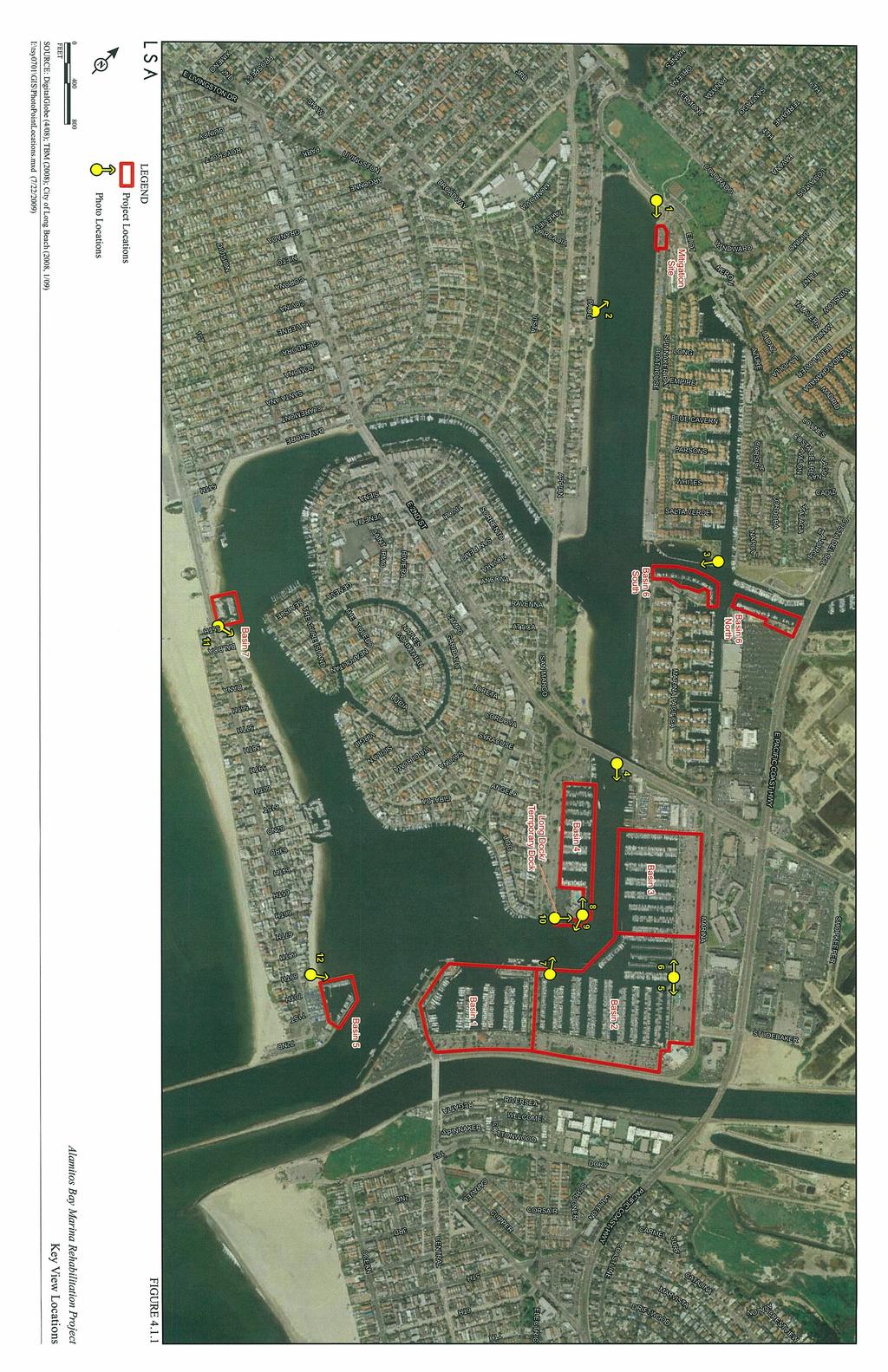
1 4.1 AESTHETICS This section provides a discussion of the existing visual and aesthetic resources on site and in the surrounding area as well as an analysis of potential impacts from implementation of the proposed Alamitos Bay Marina Rehabilitation Project. The term project area is used to refer to the combination of the Alamitos Bay Marina (Marina) Basins 1 7, the open space/mitigation habitat site, and the immediately adjacent land uses EXISTING ENVIRONMENTAL SETTING Existing Visual Character in the Vicinity of the Project Site The proposed project area, which includes Marina Basins 1 7, the proposed habitat mitigation site, and the immediately adjacent land uses, is located within the City of Long Beach (City) adjacent to and northwest of the mouth of San Gabriel River. The Alamitos Bay Marina is operated by the City of Long Beach Marine Bureau and is primary accessible from Pacific Coast Highway (PCH) and 2nd Street. The project area contains 7 miles (mi) of inland waterways for recreational water-related uses and includes private and public dock and slip facilities, guest slips, and a fuel dock. The entrance to Alamitos Bay is on the south between two jetties. The Alamitos Bay Peninsula (peninsula), which consists of beaches and residential land uses on both the bay and ocean sides, is located to the south and west of the Marina. The peninsula encloses the bay and provides protection to the bay waters from the Pacific Ocean. Naples Island, consisting primarily of residential development, is centrally located within Alamitos Bay. The surrounding land uses are primarily residential, but also include areas of commercial development, marine-related commercial uses, restaurants, recreational uses, a shipyard, yacht and sailing clubs, and public beaches. Refer to Figure 3.2 in Section 3.0, Project Description, for an aerial depiction of the project area. The general visual character of the project area is characterized by open and expansive views of the bay waters, the peninsula, Naples Island, boating facilities, and residential/commercial development in the surrounding area. Distant views outside the project area are dominated by urban development including residential uses, restaurants, hotels, and commercial businesses. In addition, long-range views to the south and southwest of the Marina include the Pacific Ocean and horizon. In addition to the boating and water-oriented recreation provided by Alamitos Bay Marina, there are several recreational amenities within the project area. Marine Stadium is located adjacent to and north of the Marina. Marine Stadium is a 1 mi long man-made water course P:\TSY0701B\Draft EIR\4.1 Aesthetics.doc «10/05/09» 4.1-1
2 that was used for the 1932 Olympic rowing competition and the 1968 Olympic rowing trials. Marine Stadium is now used for recreational water skiing and rowing and includes viewing and picnic areas, as well as a bayside beach. The proposed habitat mitigation habitat site is located adjacent to the northern terminus of Marine Stadium. Marina Park, also known as Mother s Beach, encompasses 4.60 acres (ac) and is located on the northeast side of Naples Island, along Appian Way. Mother s Beach overlooks the Marine Stadium and a portion of Basin 6-South (6-S) and contains a swimming beach, picnic areas, playground equipment, open grassy areas, and a volleyball court. Mother s Beach consists mainly of a stretch of sandy beach along the bay and ornamental landscaping, including grassy areas and mature trees. Bayshore Aquatic Park encompasses 1.8 ac and is located on the peninsula at East Ocean Boulevard and 54th Place. Bayshore Park overlooks Alamitos Bay and offers a wide range of activities, including playground equipment and picnic tables, handball, paddle tennis and racquetball courts, a roller hockey rink, boat facilities, and beach swimming. In addition, a co-op pre-school, operating during the months of September to June, is located in Bayshore Park Existing Visual Character of the Project Site The project site is an existing fully developed Marina within Alamitos Bay. The primary visual features within the project site are open waters and boats. Other elements that contribute to the visual setting include docks, pilings, gangways, gates, restroom facilities, seawalls, surface parking lots, sidewalks, and landscaped areas. All trees within the landscaped areas of Alamitos Bay Marina are ornamental and were planted during development of the Marina. Each of the basins is characterized by boats docked, gangways leading to the docked boats, seawalls, pilings, surface parking lots, and at least one restroom building per basin. Because the seven project basins are spread throughout Alamitos Bay, the visual character of each Basin is discussed below. Basin 1. Basin 1 is located on the southeastern side of the Marina. The Marine Department Headquarters, Marina parking, restaurants and marine-related commercial development surround Basin 1 on the eastern and southern boundaries of the basin. The northern portion of Basin 1 includes the concrete peninsula that separates Basins 1 and 2 and contains a fuel dock, a Long Beach Fire Department office, Marina restrooms, a yacht club facility, a grassy area, and the City of Long Beach Maurice Mossy Kent Park. The visual character of Basin 1 is dominated by views of the Marina waters, docked boats, surface parking, Marina facilities, and adjacent marine-related commercial development. Distant views from Basin 1 include the waters of the Marina, residential land uses with private slips on Naples Island, Long Beach Yacht Club (LBYC), marine-related commercial development, the San Gabriel River, and other general urban development. P:\TSY0701B\Draft EIR\4.1 Aesthetics.doc «10/05/09» 4.1-2
3 Basin 2. Basin 2 is located on the eastern corner of the Marina. Seal Beach Yacht Club, restaurants, and marine-related commercial development are located northeast of and adjacent to Basin 2. Marina parking, restaurants, and restrooms surround Basin 2 on the eastern and northern boundaries. The southwestern portion of Basin 2 is bordered by the concrete peninsula that separates Basins 1 and 2, as described above. The visual character of Basin 2 is dominated by views of the Marina waters, docked boats, surface parking, Marina facilities, a public park, and adjacent marine-related commercial development. Distant views from Basin 2 include the waters of the Marina, the Marina Channel, LBYC, marine-related commercial development, the San Gabriel River, and other general urban development. Basin 3. Basin 3 is located on the northeastern side of the Marina. The northeastern portion of Basin 3 consists of surface parking and Marina restroom facilities. The visual character of Basin 3 is dominated by views of the Marina waters, docked boats, surface parking, Marina facilities, and adjacent marine-related commercial development, including a dry dock. Distant views from Basin 3 include the waters of the Marina, LBYC, marine-related commercial development, the 2nd Street bridge, a dry dock, and other general urban development. Basin 4. Basin 4 is located on the east side of Naples Island. The western portion of Basin 4 consists of surface parking and Marina restroom facilities. The visual character of Basin 4 is dominated by views of the Marina waters, docked boats, and surface parking. Distant views from Basin 4 include the Marina waters, LBYC, residential land uses on Naples Island, marine-related commercial development, the 2nd Street Bridge, a dry dock, and other general urban development. Basin 5. Basin 5 is located in the southeastern portion of the Marina at the end of Alamitos Bay Peninsula and is enclosed by seawalls on the western and eastern sides. The visual character of Basin 5 is dominated by views of Marina waters, docked boats, and seawalls. Distant views from Basin 5 include Long Beach Marina waters, Alamitos Bay Landing, Marine Department Headquarters, Alamitos Bay Yacht Club and facilities, the entrance channel of Alamitos Bay, residential land uses on the Alamitos Bay Peninsula, sandy beaches along the inside of Alamitos Bay Peninsula, and residential land uses and private slips on Naples Island. Basin 6 North. Basin 6 is the northernmost basin within the Marina and is located east of Marine Stadium at the entrance to Los Cerritos Channel. Basin 6 consists of two sections; Basin 6 North (6-N), and Basin 6 South (6-S). Basin 6-N consists of a single row of slips, P:\TSY0701B\Draft EIR\4.1 Aesthetics.doc «10/05/09» 4.1-3
4 adjacent parking, and is accessed via the Marina Pacifica Mall commercial center located on PCH. The visual character of Basin 6-N is dominated by views of Marina waters, docked boats, Marina facilities, and Marina parking. Distant views from Basin 6-N include Los Cerritos Channel waters, the PCH bridge over Los Cerritos Channel, other marine facilities, grass landscaped open space, residential land uses, Marina Pacifica Mall, and Basin 6-S. Basin 6 South. Basin 6-S is located adjacent to the residential community of Marina Pacifica and consists of a single row of slips and surface parking. The visual character of Basin 6-S is dominated by views of marine waters, docked boats, Marina facilities, Marina parking, and grass landscaped open space. Distant views from Basin 6-S include Los Cerritos Channel waters, Alamitos Bay and Marine Stadium waters, Mother s Beach, land side urban development, Marina Pacifica Mall, Marina Pacifica residential land uses with private slips, Basin 6-N, Prince Island, California State University Boat House, residential land uses, and open space. Basin 7. Basin 7 is the westernmost basin within the Marina and located at the United States Sailing Center (USSC), on the interior side of the Alamitos Bay Peninsula. Basin 7 includes approximately 30 slips, associated parking, and restroom facilities adjacent to the USSC facilities. The visual character of Basin 7 is dominated by views of marine waters, docked boats, Marina facilities, Marina parking, and the USSC. Distant views from Basin 7 include marine waters, sandy beaches north, east, and west of Basin 7, Bay Shore Avenue, Bayside Aquatic Park, beach side residential uses, and residential uses with private slips on Treasure Island and Naples Island. Open Space/Habitat Mitigation Site. The project includes a new open space marine habitat area that would be planted with eelgrass to mitigate for the project s potential impacts to this marine resource. The proposed habitat mitigation site is located adjacent to the northeast end of Marine Stadium. The site is a City-owned storage area bound by on the north by portions of Boathouse Lane and the open space nature trail, on the east by Boathouse Lane, on the south by the fenced storage area, and on the west by a rock revetment (riprap) that separates the site from Marine Stadium. The visual character of the site is dominated by views of Marine Stadium waters, End Beach (a sandy area located at the end of Marine Stadium that is fenced off from public access), the rock revetment extending along the east and west sides of Marine Stadium, and the remainder of the storage area. Distant views from the mitigation site include Marina Vista Park, parking areas and residential uses adjacent to the western side of Marine Stadium, and Marina waters. P:\TSY0701B\Draft EIR\4.1 Aesthetics.doc «10/05/09» 4.1-4
5 Light and Glare Alamitos Bay Marina is located within an urbanized area surrounded by a mix of residential, retail, commercial, and recreational land uses. These existing uses (including the existing Marina use) utilize interior and exterior building lighting, parking lot lighting, and landscape lighting. Light sources also include light generated by passing vehicles and street lighting. Safety lighting is provided on all docks and facilities within the Marina REGULATORY SETTING City of Long Beach Planning Documents The City s Open Space and Recreation Element of the General Plan and the Long Beach Department of Parks, Recreation, and Marine Strategic Plan contain objectives and policies related to aesthetics and visual character. The applicable objectives and policies are listed below. Open Space and Recreation Element Policy 1.2: Protect and improve the community s natural resources, amenities, and scenic values, including nature centers, beaches, bluffs, wetlands, and water bodies. Open Space and Recreation Element Policy 4.1: Create additional recreation open space and pursue all appropriate available funding to enhance recreation opportunities. Marine Strategic Plan Goal 4: Ensure beaches, waterways, and marine amenities are accessible and provide a positive experience and image. City of Long Beach Scenic Routes Element. According to the City of Long Beach Scenic Routes Element (1975), 2nd Street and Marina Drive are identified as potential local scenic routes. The 2nd Street Bridge crosses over the Marina Channel within the project vicinity and provides views of Basin 3, Basin 4, and Basin 2. Marina Drive is located on the southeastern boundary of Basin 1 and Basin 2, and the northeastern boundary of Basin 2 and Basin 3, and provides views of these basins. However, neither of these routes has been officially designated as a Scenic Route or Scenic Highway. According to the Scenic Routes Element, Ocean Boulevard, located on the Alamitos Bay Peninsula southwest of the project site, is designated as a scenic route. Basin 5 and Basin 7 are located on the peninsula and are accessed via Ocean Boulevard. City of Long Beach Municipal Code. Chapter requires that a permit be obtained from the Director of Public Works prior to removal of trees from City-owned property. The City also requires that the trees be identified, mapped, and measured prior to removal. In addition, P:\TSY0701B\Draft EIR\4.1 Aesthetics.doc «10/05/09» 4.1-5
6 the City s Department of Parks, Recreation, and Marine has a Tidelands Area Tree Trimming policy that provides guidelines and procedures for trimming trees within the Tidelands area California Coastal Act The policies included in the California Coastal Act (Sections 30200, et al.), Article 3, are intended to protect certain water-oriented activities, recreational boating uses, marine-related recreational facilities, and development of the ocean front land. The activities covered in Article 3 also include dredging and movement of sediments and nutrients from the ocean floor. An applicable Coastal Act visual/aesthetic policy is listed below. The scenic and visual qualities of coastal areas shall be considered and protected as a resource of public importance. Permitted development shall be sited and designed to protect views to and along the ocean and scenic coast areas, to minimize the alteration of natural landforms, to be visually compatible with the character of surrounding areas, and where feasible, to restore and enhance visual quality in visually degraded areas. New development in highly scenic areas such as those designated in the California Coastline Preservation and Recreation Plan prepared by the Department of Parks and Recreation and by local government shall be subordinate to the character of its setting (California Coastal Act, Section 30251) State Scenic Highways According to the California Department of Transportation (Caltrans), 1 portions of State Route 1 (SR-1) or PCH, are designated as an Eligible State Scenic Highway Not Officially Designated. PCH is located north of the project site and borders the northwestern edge of Basin 6-N. The majority of the views of the project site from PCH are obstructed by existing development and topography. Distant views of the boats are intermittently provided from the viewpoint of a driver along PCH. In addition, no other State scenic highways are in the vicinity of the proposed project METHODOLOGY As discussed in detail in Section 3.0, Project Description, the proposed project involves improvements to Marina facilities in Basins 1 through 7, and the construction of an approximately 565-foot (ft) long dock (200 ft of the dock is temporary [for the duration of the project construction]) located adjacent to Basin 4 at the southeast corner of the LBYC. In addition, based on preliminary analysis, dredging activities would require mitigation for potential impacts to marine eelgrass. The City has identified a site adjacent to the northeast 1 Website: California Department of Transportation, California Scenic Highway Mapping System: (accessed July 16, 2009). P:\TSY0701B\Draft EIR\4.1 Aesthetics.doc «10/05/09» 4.1-6
7 end of Marina Stadium to convert to an open space/habitat mitigation site. A field visit was conducted to gather photographs of the project area and to assist in the evaluation of potential aesthetic impacts of the proposed project. The potential aesthetic impacts of the proposed project were evaluated considering such factors as the scale, mass, proportion, orientation, and landscaping/buffering associated with design of the proposed project. Because implementation of the proposed project would be consistent with the existing Alamitos Bay development, would replace Marina facilities with similar structures, and would not be considered out of character with the scale, mass, proportion, orientation, and landscaping/buffering associated with the existing uses, view simulations were not required for the analysis. However, existing views are provided in Figures through Where appropriate, indicators have been added to the existing view figures indicating where construction or additional development would occur. A comparison of the existing visual setting to the proposed visual setting has been thoroughly analyzed using descriptive text. In order to evaluate the aesthetic impacts of the proposed project, potential visual changes were identified based on field reconnaissance, photographs taken from on- and off-site vantage points, and aerial photographs. As discussed above, 12 view locations of the project site from publicly accessible vantage points were selected to best depict the potential change in views from the current condition. The project is anticipated to be completed in 12 phases over approximately 6 years and includes two construction staging areas: one located in the parking lot on Marina Drive near Basin 2; and one located in the parking lot on Marina Drive near Basin 3, adjacent to the Marina Shipyard. Visual impacts resulting from construction of the proposed project have also been thoroughly analyzed using descriptive text. In addition to the textual description of the visual change, compliance with the goals and policies set forth in the City of Long Beach General Plan Open Space and Recreation Element, Scenic Routes Element, Marine Strategic Plan, Local Coastal Program, and Parks Recreation Marine Strategic Plan were evaluated THRESHOLDS OF SIGNIFICANCE According to Appendix G of the State CEQA Guidelines, the proposed project may be considered to have a significant effect related to aesthetics if any of the following would occur: Have a substantial adverse effect on a scenic vista; Cause substantial damage to scenic resources, including, but not limited to, trees, rock outcroppings, and historic buildings within a state scenic highway; P:\TSY0701B\Draft EIR\4.1 Aesthetics.doc «10/05/09» 4.1-7
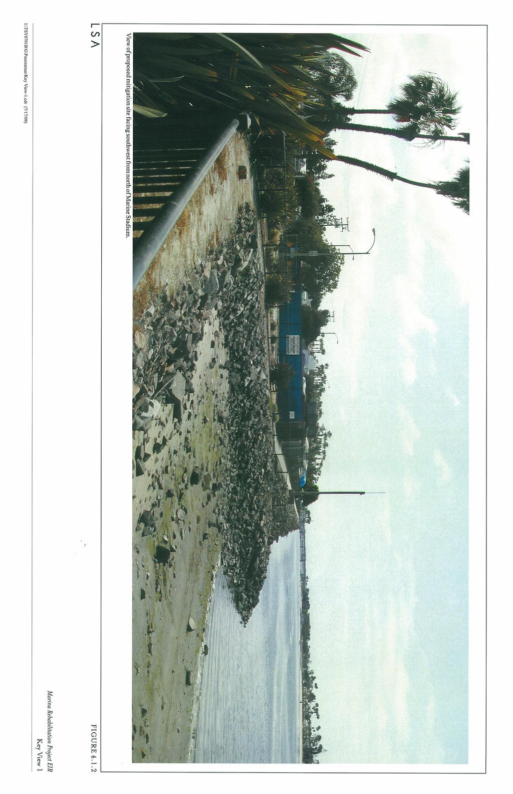
8 Substantially degrade the existing visual character or quality of the site and its surroundings; or Create a new source of substantial light or glare, which would adversely affect day or nighttime views in the area IMPACTS AND MITIGATION MEASURES Less Than Significant Impacts The following aesthetic impacts that could result from implementation of the project were evaluated and are considered to be less than significant. Scenic Vista and Visual Character. This subsection addresses public views of the project site and how they would be affected by the proposed project. Figure is provided to indicate the locations of each of the 12 vantage points or Key View locations. Existing views of the project site and coverage areas of the 12 vantage points are provided in Figures through The following analysis addresses whether there is a significant impact on the environment with regard to changes to the scenic vistas and visual character of the project area. The discussion for each Key View analyzes the following project areas: Key Views 1 and 2 address the proposed habitat mitigation site. Key View 3 addresses Basins 6-N and 6-S. Key View 4 primarily addresses Basins 3 and 4. Key Views 5 and 6 primarily address Basins 1 3. Key Views 7 10 address the temporary/long dock, views associated with the LBYC, Basin 4, and residential uses on Naples Island. Key View 11 addresses Basin 7. Key View 12 addresses Basin 5. Key View 1: Proposed Mitigation Site Facing Southeast from North of Marine Stadium. As described in Section 3.0, Project Description, the City has identified this site adjacent to the northeast shore of Marine Stadium for conversion to an open space/habitat mitigation site. Figure provides an existing view of the proposed mitigation site from the recreational trails located at the north end of Marine Stadium. This view is representative of typical views surrounding the proposed mitigation site from the recreational uses north of the proposed mitigation site. Existing views of the proposed mitigation site include a rocky/sandy beach (not publically accessible), ornamental vegetation, and steel fencing in the foreground. Middleground views include the rocky/sandy beach, ornamental vegetation, waters at the north end of Marine P:\TSY0701B\Draft EIR\4.1 Aesthetics.doc «10/05/09» 4.1-8
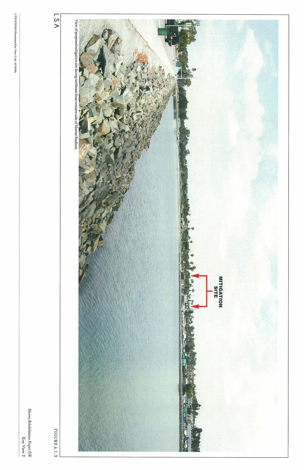
9 Stadium, marine storage, steel fencing, and riprap. Background views include ornamental vegetation, marine storage, Marine Stadium, Marina Channel, Second Street Bridge, Mother s Beach, beach side residential uses, and sky. The visual character surrounding the proposed mitigation site can be described as marine usage surrounding open waters and recreational uses. The project includes abandoning a portion of the existing storage yard to create an open space habitat. An area of 218 x 105 ft would be excavated to a depth of 2 3 ft below mean low lower water (MLLW), and the existing rock revetment along Marine Stadium would be relocated to the eastern boundary of the site to allow the area to fill with water from the adjacent channel (see Figure 3.14 in Section 3.0, Project Description). The new open space water area would be planted with eelgrass to mitigate for the project s potential impacts to this marine resource. During construction of the proposed open space/habitat mitigation site, visual impacts would occur to the recreational areas within view of and immediately northwest of the site. However, these visual impacts resulting from construction of the proposed open space/habitat mitigation site would be temporary and considered less than significant. Changes in the permanent views of the proposed open space/habitat mitigation site would consist of a reduced amount of fenced storage area, an increased amount of marine waters, a proposed nonaccessible dock (wave attenuator) that protects the habitat area and delineates Marine Stadium, and a shift in the riprap to the northeast. This change in the positioning of the riprap would alter the view of Marine Stadium from the recreational uses north of Marine Stadium by visually increasing the water area. However, this change in view would not substantially degrade the existing visual character or quality of the site and its surroundings. The proposed open space/habitat mitigation site would not result in a change in the visual character of the area surrounding the north end of Marine Stadium. Therefore, any impact resulting from the proposed open space/habitat mitigation site to visual resources surrounding the north end of Marine Stadium would be considered less than significant. Key View 2: Proposed Mitigation Site Facing Northeast from the Western Side of Marine Stadium. Figure provides an existing view of the proposed mitigation site from the parking lot adjacent to the northwestern end of Marine Stadium. This view is representative of typical views of the mitigation site from the western side of Marine Stadium. Existing views of the proposed mitigation site include riprap, the storage area, and Marine Stadium waters in the foreground. Middleground views include parking, viewer s stand adjacent to Marine Stadium, riprap, Marine Stadium waters, and marine boat storage. Background views include ornamental mature vegetation, recreational uses north of Marine Stadium, the proposed mitigation site, and sky. The visual character surrounding the proposed mitigation site can be described as marine usage surrounding open waters and recreational uses. P:\TSY0701B\Draft EIR\4.1 Aesthetics.doc «10/05/09» 4.1-9
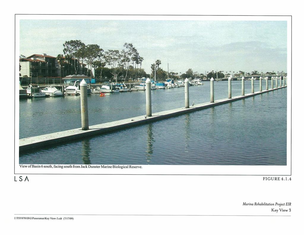
10 Construction of the proposed open space/habitat mitigation site would be visible from the west side of Marine Stadium; however, views of the proposed site are at a distance of at least 500 ft. In addition, visual impacts resulting from construction of the proposed open space/habitat mitigation site would be temporary and considered less than significant. Similar to Key View 1, postproject views of the proposed open space/habitat mitigation site would consist of a reduced amount of fenced storage area, an increased amount of marine waters, the wave attenuator, and a shift in the riprap to the northeast. Because of the distance from the proposed site, impacts to views from across (on the west side of) Marine Stadium of the site would be considered less than significant. In addition, the proposed open space/habitat mitigation site would not substantially degrade the existing visual character or quality of the site and its surroundings. The proposed open space/ habitat mitigation site would not result in a change in the visual character of the area surrounding the north end of Marine Stadium. Therefore, any impact resulting from the proposed open space/habitat mitigation site to visual resources on the west side of Marine Stadium would be considered less than significant. Key View 3: Basin 6-S, Facing South from Jack Dunster Marine Biological Reserve. Figure provides an existing view of Basin 6-S from the Jack Dunster Marine Biological Reserve looking south across Marina waters toward Marine Stadium and the Appian Way bridge. This view is representative of typical views of Basin 6 S from the residential uses northwest of Basin 6-S, recreational users of the public trail located within the Jack Dunster Marine Biological Reserve, and views from the docks at the southern end of the Long Beach Rowing Center. Existing views of Basin 6-S include the biological reserve, nonaccessible dock and pilings protecting the biological reserve, and Basin 6 channel waters in the foreground. Middleground views include boats docked within Basin 6-S and Marine Stadium. Background views include residential uses located southeast of Basin 6-S, mature ornamental vegetation, the Appian Way Bridge, residential uses southwest of Marine Stadium, and sky. The visual character of the area surrounding Basin 6-S can be described as marine recreational uses surrounded by residential and commercial uses. The proposed project would remodel and renovate in place the restroom structures located in Basins 6-S and 6-N and replace the marine pilings and docks within Basins 6-S and 6-N. During construction of the proposed project, views of the pilings, docks and restrooms would be visible from the areas surrounding Basins 6-S and 6-N. However, any visual impact resulting from construction of the proposed project would be temporary. Postproject construction views of Basins 6-S and 6-N would be similar to the existing views and consist of newly renovated pilings, docks, and restrooms, and would be considered a visual improvement from the existing setting. The proposed project would not result in a change in the visual character of the area surrounding Basins 6-S and 6-N. Therefore, any impact to visual resources surrounding Basins 6-S and 6-N P:\TSY0701B\Draft EIR\4.1 Aesthetics.doc «10/05/09»
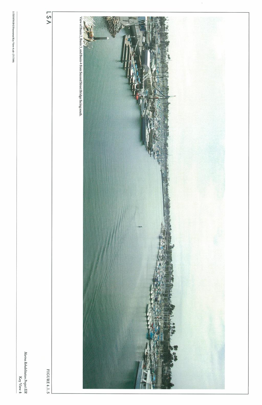
11 resulting from construction or operation of the proposed project would be considered less than significant. Key View 4: Basins 2 4 from Second Street Bridge Facing South. Figure provides an existing view of Basins 3 and 4, and further in the distance Basin 2, from the Second Street Bridge facing south. This view is representative of elevated views of Alamitos Bay from the Second Street Bridge. Existing views include the Marina Channel waters and Marina storage in the foreground. Middleground views include boats docked at Basin 3, the Marina Channel waters, and boats docked at Basin 4. Background views include mature trees, Basin 2, the seawall located on the western side of Basin 2, LBYC, residential uses on Naples Island, and sky. The visual character of this area of Alamitos Bay can be described as marine uses and open marine channel waters. The proposed project would remove and replace the docks and pilings in Basins 3 and 4. During construction of the proposed project, views of the docks and pilings would be visible from the Second Street Bridge. Construction of the proposed project will occur in phases; therefore, construction of Basins 3 and 4 would not occur simultaneously. However, any visual impact resulting from construction of the proposed project would be temporary. Postproject construction views of Basins 3 and 4 would be similar to the existing views and consist of newly renovated pilings and docks. Construction of the proposed project also includes renovations and/or reconstruction of the restrooms located adjacent to Basins 3 and 4; however, it is unlikely that construction of these restroom facilities would be visible from the Second Street Bridge. In addition, the renovated pilings, docks, and restrooms would be considered a visual improvement from the existing setting. The proposed project would not result in a change in the visual character of the area surrounding Basins 3 and 4. Therefore, any impact to visual resources surrounding Basins 3 and 4 resulting from construction or operation of the proposed project would be considered less than significant. Key View 5: Basin 2 from Sidewalk East of Basin 2 Facing South. Figure provides an existing view of Basin 2 from the adjacent sidewalk facing south. This view is representative of general views from the sidewalk adjacent to Basins 1 4. Existing views include sidewalk, steel fencing, docks, small boat on-dock storage, boats docked, pilings, and gangways in the foreground. Middleground views include parking area landscaping, Marina commercial and restaurant uses, docks, boats docked, pilings, and channel waters. Background views include mature trees, Seal Beach Yacht Club facilities, Marina commercial, restaurant uses, and sky. The visual character can be described as marine recreational surrounded by commercial and restaurants. With implementation of the proposed project, the restroom facilities would be renovated in place and/or reconstructed, and docks and pilings would be removed and replaced in P:\TSY0701B\Draft EIR\4.1 Aesthetics.doc «10/05/09»
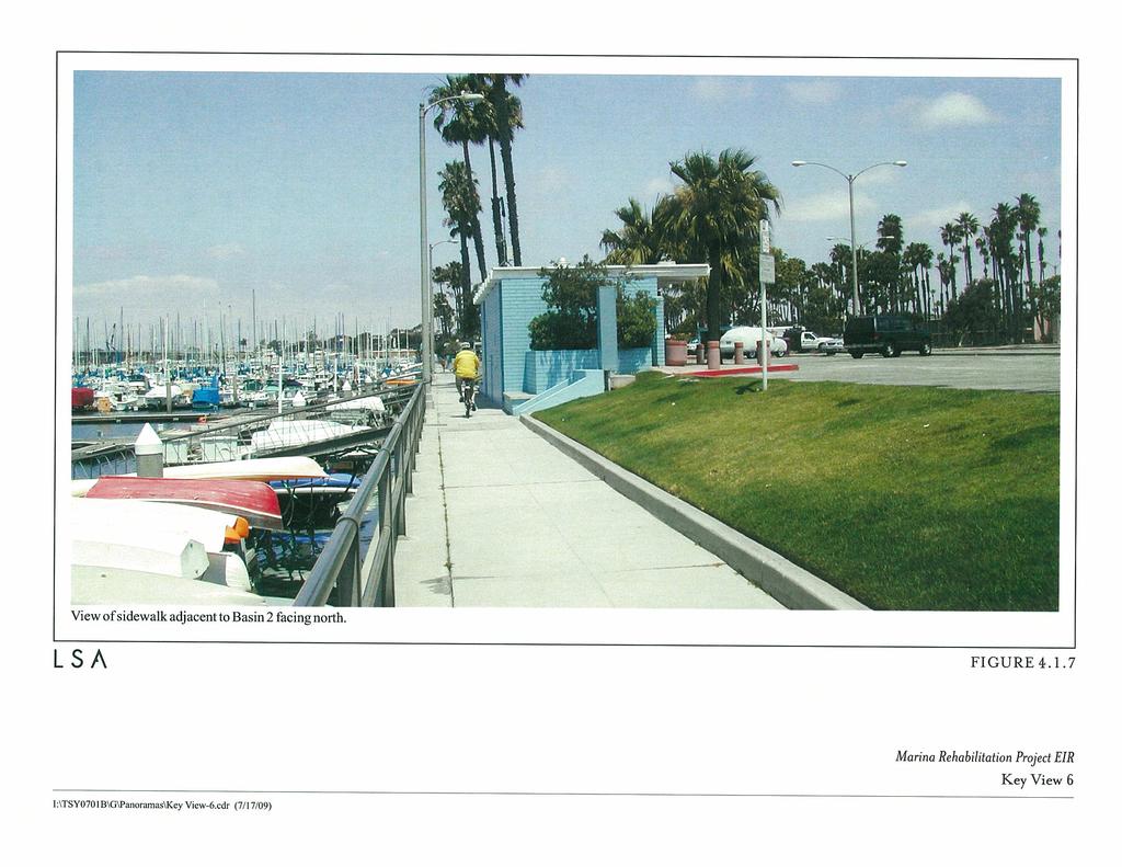
12 Basins 1 4. During construction of the proposed project, views of the restrooms, docks and pilings would be visible from the sidewalks adjacent to Basins 1 4. Construction of the proposed project will occur in phases; therefore, construction of Basins 1 4 would not occur simultaneously. However, any visual impact resulting from construction of the proposed project would be temporary. Postproject construction views of Basins 1 4 would be similar to the existing views and consist of newly renovated pilings, docks, and restrooms, and would be considered a visual improvement from the existing setting. The proposed project would not result in a change in the visual character of the area surrounding Basins 1 4. Therefore, any impact to visual resources surrounding Basins 1 4 resulting from construction or operation of the proposed project would be considered less than significant. Key View 6: Sidewalk Adjacent to Basin 2 Facing North. Figure provides an existing view of the sidewalk adjacent to Basin 2 facing north. This view is similar to Key View 5 and is representative of general views along the sidewalks adjacent to Basins 1 4. Existing views include sidewalk, steel fencing, small boat storage, pilings, sidewalk, and grass landscaping in the foreground. Middleground views include parking, Marina restroom facilities, sidewalk, and boats docked in Basin 2. Background views include mature trees, ornamental vegetation, boats docked in Basin 3, and sky. The visual character can be described as marine recreational surrounded by marine facilities. With implementation of the proposed project, the restroom facilities would be renovated in place and/or reconstructed, and docks and pilings would be removed and replaced in Basins 1 4. During construction of the proposed project, views of the restrooms, docks, and pilings would be visible from the sidewalks adjacent to Basins 1 4. Construction of the proposed project will occur in phases; therefore, construction of Basins 1 4 would not occur simultaneously. However, any visual impact resulting from construction of the proposed project would be temporary. Postproject construction views of Basins 1 4, would be similar to the existing views and consist of newly renovated pilings, docks, and restrooms, and would be considered a visual improvement from the existing setting. The proposed project would not result in a change in the visual character of the area surrounding Basins 1 4. Therefore, any impact to visual resources surrounding Basins 1 4 resulting from construction or operation of the proposed project would be considered less than significant. Key View 7: Marina Channel and LBYC on Naples Island from Maurice Mossy Kent Park in Basin 2 Facing North. Figure provides an existing view of the Marina channel, the southeast end of Naples Island, and LBYC from Maurice Mossy Kent Park in Basin 2, facing north. This view is representative of general Marina views from the north side of Basins 1 and 2. Existing views include open marine waters in the foreground. Middleground views include open marine waters, residential uses on Naples P:\TSY0701B\Draft EIR\4.1 Aesthetics.doc «10/05/09»
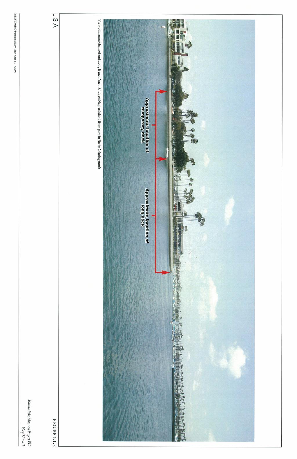
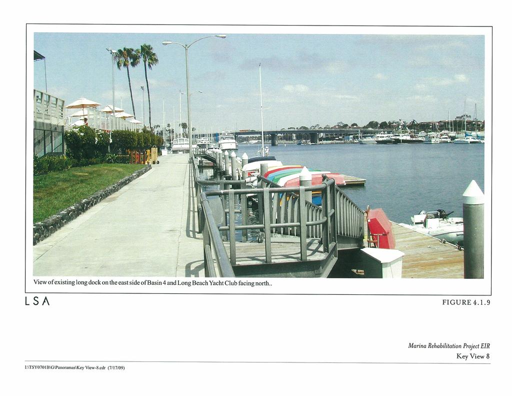
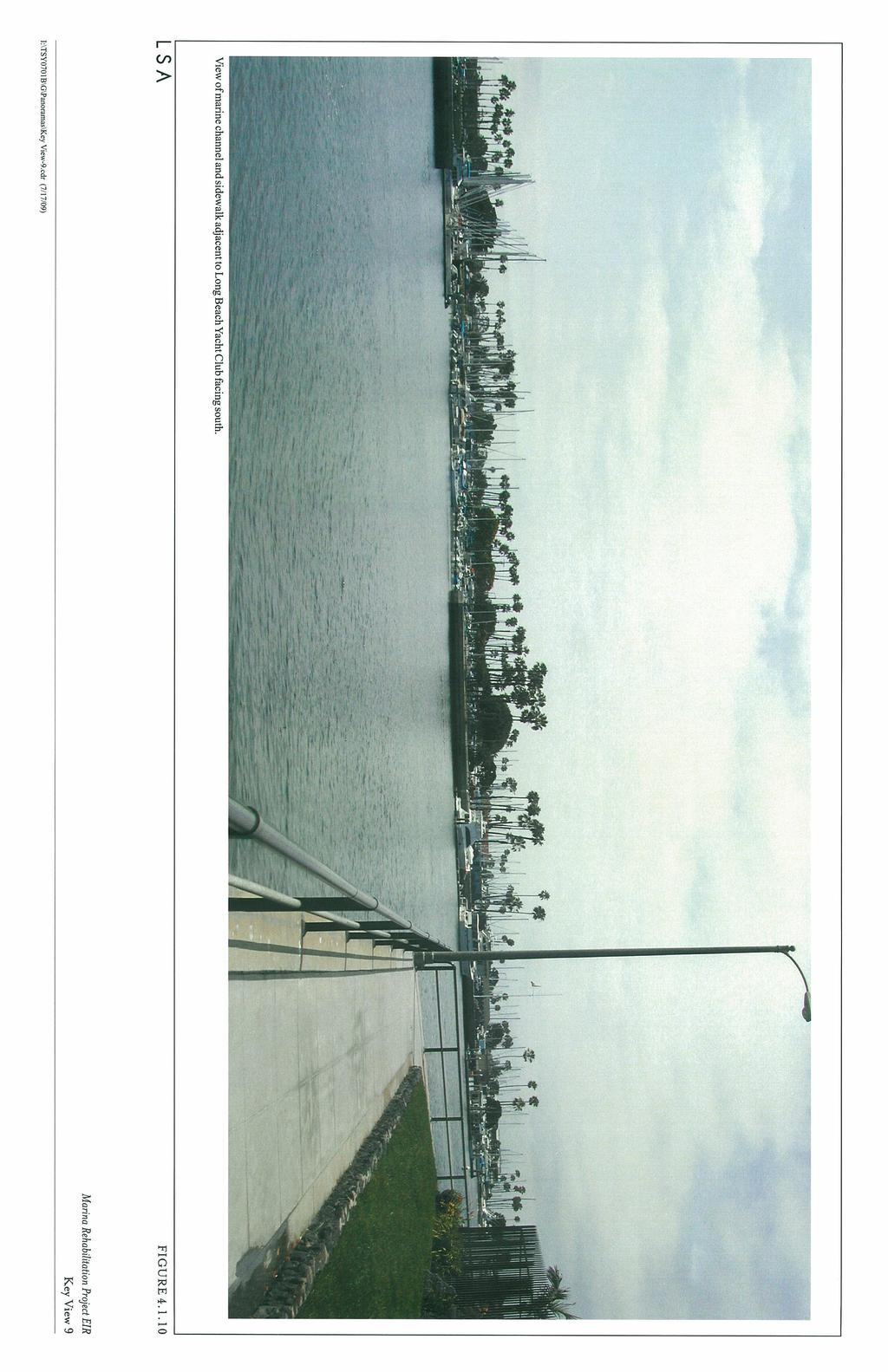
13 Island, boats docked adjacent to residential uses on Naples Island, mature ornamental vegetation, LBYC, boats docked in Basins 2 and 3, and a seawall. Background views include sky and distant mature trees. The visual character can be described as open marine channel, marine recreational facilities, and marine residential. The proposed project includes replacement and extension of the long dock located adjacent to the LBYC at the southeast end of Basin 4. The new 10 ft wide long dock would be extended by approximately 565 ft from where it currently ends. However, approximately 200 ft of this long dock is temporary and is intended to accommodate displaced boats during each phase of the Marina rehabilitation process. The 200 ft temporary portion of the dock will be removed upon project completion. No additional gangway is planned for the temporary/long dock; access to this dock would continue to be made from existing gangways located at the southeast end of Basin 4. See Figure 3.13 and Section 3.0 for more detail. Construction of the long dock would be visible from surrounding areas; however, visual impacts due to construction activities would be temporary and therefore considered less than significant. Views of the temporary portion of the long dock would be visible during construction, and any impacts to visual resources due to the temporary portion of the long dock would be temporary and therefore considered less than significant. Views of the portion of the long dock to remain after project completion would be visible during operation of the proposed project; however, these views of the long dock would not impact the visual character of the project area, nor would views of the open marine waters or sky be blocked. Views of the seawall on Naples Island would be partially obstructed, and depending on the size of boats docked at the long dock, views of LBYC may be partially obstructed. However, these changes would not impact the visual character of this area of Alamitos Bay, and the visual character would remain open marine channel, marine recreational facilities, and marine residential. Postproject views of Basins 1 4 would be similar to the existing views and consist of a newly renovated seawall, which would be considered a visual improvement from the existing setting. The proposed project would not result in a change in the visual character of the area surrounding Basins 1 4. Therefore, any impact to visual resources surrounding Basins 1 4 resulting from construction or operation of the proposed project would be considered less than significant. Key View 8: Existing Long Dock on the East Side of Basin 4 and LBYC Facing North. Figure provides an existing view of the existing long dock adjacent to Basin 4 and LBYC from the adjacent sidewalk facing north. This view is representative of general views from the sidewalk adjacent to LBYC. Existing views include sidewalk, steel fencing, a gangway, docks, pilings, and grass landscaping in the foreground. Middleground views include small boat on-dock storage, docks, pilings, gangways, landscaping, LBYC facilities, and channel waters. Background views include mature P:\TSY0701B\Draft EIR\4.1 Aesthetics.doc «10/05/09»
14 trees, boats docked in Basin 4, Marina Channel waters, Second Street Bridge, Marine Stadium, boats docked in Basin 3, mature trees, and sky. The visual character can be described as marine recreational facilities surrounded by open marine channel. As discussed above, the proposed project includes replacement and extension of the long dock located adjacent to the LBYC at the southeast end of Basin 4. The existing long dock depicted in Figure is the existing long dock from which the proposed dock will be extended. In addition, Figure provides an example of the type of long dock that would be constructed as part of the proposed project. During construction of the proposed project, views of the long dock would be visible from the sidewalk adjacent to Basin 4. Any visual impact resulting from construction of the proposed project would be temporary and therefore less than significant. Postproject construction views of the long dock adjacent to Basin 4 would be similar to the existing views and consist of newly renovated pilings and docks and would be considered a visual improvement from the existing setting. The extension of the long dock would not result in a change in the visual character of the area surrounding Basin 4 and the LBYC. Therefore, any impact to visual resources surrounding Basin 4 resulting from construction or operation of the proposed project would be considered less than significant. Key View 9: Marine Channel and Sidewalk Adjacent to LBYC Facing South. Figure provides an existing view of the marine channel and sidewalk adjacent to LBYC facing south. This view is representative of general views from the sidewalk wrapping around the southeast side of LBYC. Existing views include the sidewalk, steel fencing, landscaping, and open channel in the foreground. Middleground views include open channel, steel fencing, sidewalk, landscaping, and LBYC facilities. Background views include the Basin 2 seawall, boats docked in Basins 1 and 2, Maurice Mossy Kent Park at the end of the peninsula separating Basins 1 and 2, Long Beach Fire Department Facilities, marine gas station facilities, mature trees, and sky. The visual character can be described as marine recreational facilities surrounded by open marine channel. As discussed above, the proposed project includes extension of the long dock located adjacent to LBYC at the southeast end of Basin 4. The proposed long dock would be extended and would be visible from this view location. During construction of the proposed project, views of the long dock would be visible from this location; however, any visual impact resulting from construction of the proposed project would be considered temporary and therefore less than significant. Postproject construction views of the long dock adjacent to Basin 4 would be visible from this view location. The long dock would appear immediately to the left of and adjacent to the sidewalk depicted in this view, and displaced boats would be docked at the proposed long dock. From this view location, foreground views of the open channel would be obstructed by the proposed long dock and boats docked at the long dock. However, the proposed long dock and boats P:\TSY0701B\Draft EIR\4.1 Aesthetics.doc «10/05/09»
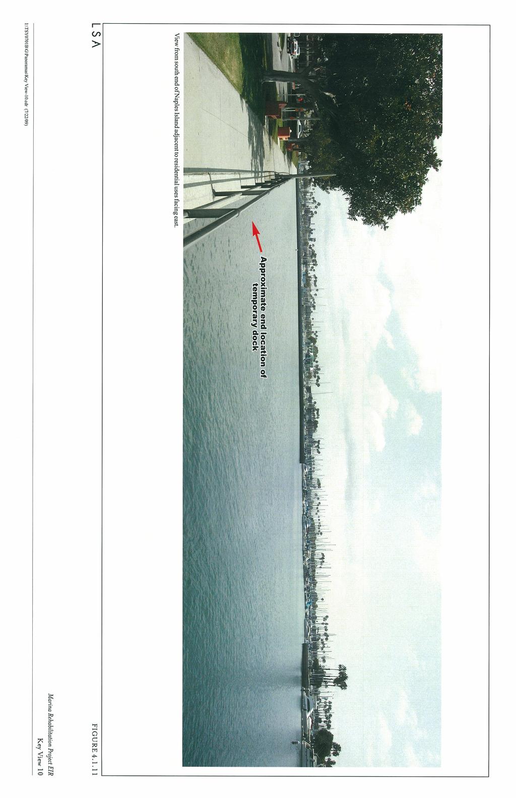
15 docked at it would not change the visual character of this view and surrounding area. The visual character would remain marine recreational facilities surrounded by open marine channel. Therefore, any impact to visual resources surrounding LBYC and Basin 4 resulting from construction of the proposed long dock would be considered less than significant. In addition, during construction of the proposed project, views of the docks and pilings in Basins 1 and 2 would be visible from this view location. Construction of the proposed project will occur in phases; therefore, construction of Basins 1 and 2 would not occur simultaneously. However, any visual impact resulting from construction of the proposed project would be temporary. Postproject construction views of Basins 1 and 2 would be similar to the existing views and consist of newly renovated pilings and docks and would be considered a visual improvement from the existing setting. The proposed project would not result in a change in the visual character of the area surrounding Basins 1 4. Therefore, any impact to visual resources surrounding Basins 1 4 resulting from construction or operation of the proposed project would be considered less than significant. Key View 10: South End of Naples Island Adjacent to Residential Uses Facing East. Figure provides an existing view from the south end of Naples Island adjacent to residential uses and sidewalk facing east. This view is representative of typical views from the south end of Naples Island adjacent to residential uses and LBYC. Existing views include sidewalk, landscaping, steel fencing, and open channel waters in the foreground. Middleground views include mature trees, landscaping, benches, sidewalk, steel fencing, and open channel waters. Background views include LBYC facilities, sidewalk, Basin 2, the seawall adjacent to Basin 2, boats docked in Basin 2, mature trees, Maurice Mossy Kent Park at the end the peninsula separating Basins 1 and 2, and Fire Department facilities. The visual character can be described as marine recreational facilities surrounded by open channel. The proposed long dock would be extended and would be visible from this view location. During construction of the proposed project, views of the long dock would be visible from this location; however, any visual impact resulting from construction of the proposed project would be considered temporary and therefore less than significant. Postproject construction views of the long dock adjacent to LBYC would be visible from this view location. The long dock would appear immediately to the right of and adjacent to the sidewalk depicted in this view, and displaced boats would be docked at the proposed long dock. From this view location, foreground views of the open channel would be obstructed by the proposed long dock and boats docked at the long dock. However, the proposed long dock and boats docked at it would not change the visual character of this view and surrounding area. The visual character would remain marine recreational facilities surrounded by open marine channel. Therefore, any impact to P:\TSY0701B\Draft EIR\4.1 Aesthetics.doc «10/05/09»
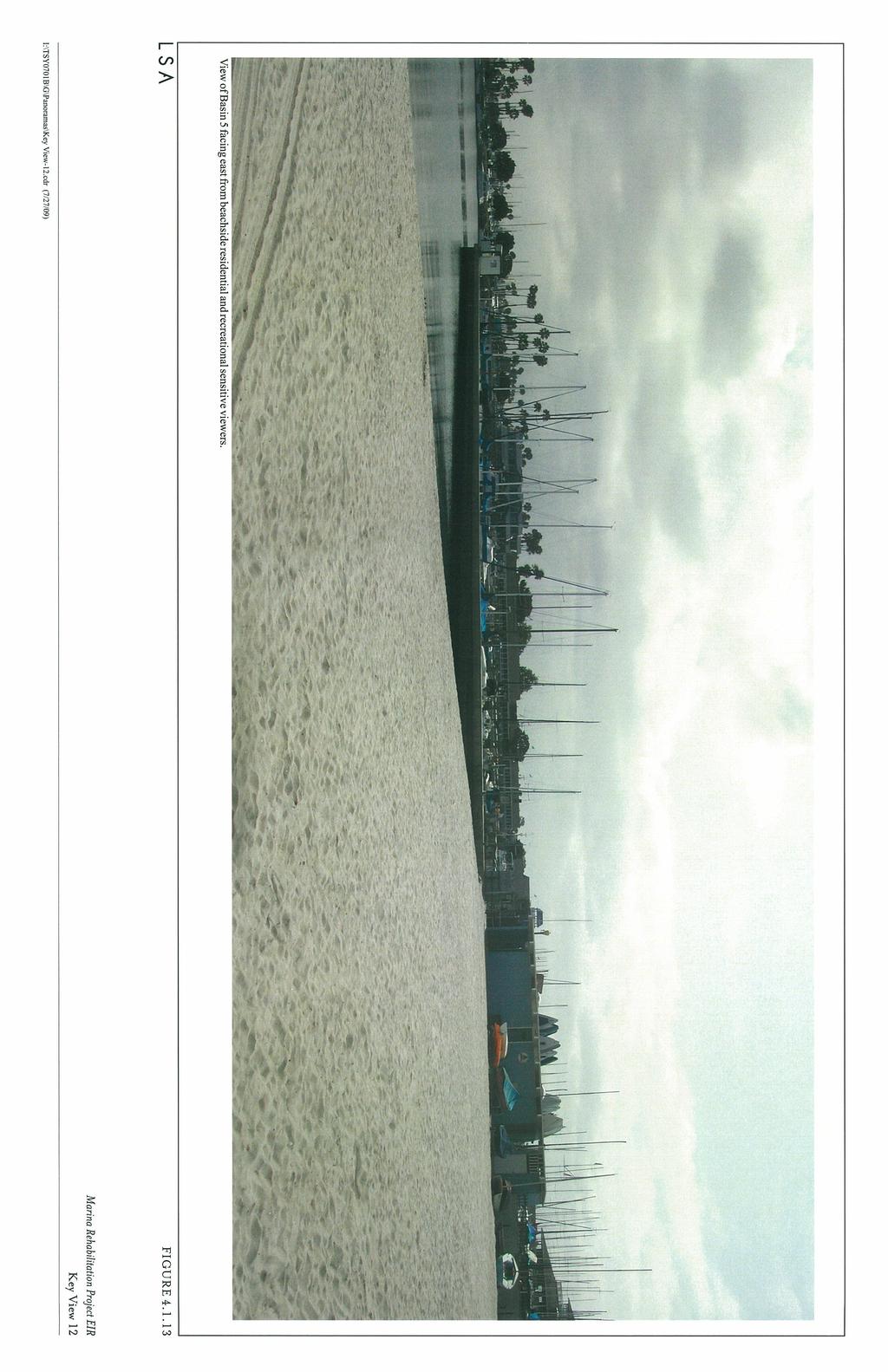
16 visual resources surrounding the south end of Naples Island and LBYC resulting from construction of the proposed long dock would be considered less than significant. In addition, during construction of the proposed project, views of the docks and pilings in Basin 2 would be visible from this view location. However, any visual impact resulting from construction of the proposed project would be temporary. Postproject construction views of Basin 2 would be similar to the existing views and consist of newly renovated pilings and docks that would be considered a visual improvement from the existing setting. The proposed project would not result in a change in the visual character from this view location. Therefore, any impact to visual resources from this view location resulting from construction and/or operation of the proposed project would be considered less than significant. Key View 11 of Basin 7 from Ocean Boulevard Traveling East. Figure provides an existing view of Basin 7 from Ocean Boulevard traveling east. According to the City s General Plan, Scenic Routes Element, Ocean Boulevard, located on the Alamitos Bay Peninsula, southwest of the project site, is designated as a scenic route. General views from Ocean Boulevard consist of views of the Marina, marine facilities, marine recreation facilities, beach side residential along Ocean Boulevard, sandy beaches on both sides of Ocean Boulevard, and views of the Long Beach Harbor to the south. Basin 7 of the proposed project would be visible from Ocean Boulevard. As depicted in Figure , views of Basin 7 from Ocean Boulevard traveling east would consist of views of the docks and existing restroom facilities. The proposed project would remodel and renovate in place the restroom structure located in Basin 7 and replace the marine pilings and docks. During construction of the proposed project, views of the restroom renovation, pilings, and dock replacement would be visible from Ocean Boulevard. However, any visual impact resulting from construction of the proposed project would be temporary. Postproject construction views of Basin 7 from Ocean Boulevard would be similar to the existing views and consist of newly renovated restroom facilities, docks, and marine pilings that would be considered a visual improvement from the existing setting. The proposed project would not result in a change in visual character to the scenic route of Ocean Boulevard. Therefore, any impact to visual resources surrounding Basin 7 resulting from construction or operation of the proposed project would be considered less than significant. Key View 12 of Basin 5 from Beachside Residential and Recreational Sensitive Viewers. Figure provides an existing view of Basin 5 from the beach side residential uses on the interior (east side) of the peninsula looking east. This view is representative of typical views from the residential uses located on the interior of the peninsula and persons using the beach adjacent to Basin 5 for recreational purposes. P:\TSY0701B\Draft EIR\4.1 Aesthetics.doc «10/05/09»
17 Existing views of Basin 5 from the beach include sand in the foreground, Basin 5 seawall, Basin 5 restroom, small craft storage, Marina waters, and boats docked within Basin 5 in the middleground. Background views consist of distant docked boats in Basin 1, Marina commercial uses, mature ornamental vegetation, and sky. The visual character of the area surrounding Basin 5 can be described as recreational and beach side residential. The proposed project would reconstruct the restroom building and replace the marine pilings and docks within Basin 5. During construction of the proposed project, views of the seawall would be visible from the adjacent beach and residential uses. However, any visual impact resulting from construction of the proposed project would be temporary. Postproject construction views of Basin 5 from the adjacent beach and residential uses would be similar to the existing views and consist of newly renovated docks and a restroom building within the Basin that would be considered a visual improvement from the existing setting. The proposed project would not result in a change in the visual character of the area surrounding Basin 5. Therefore, any impact to visual resources surrounding Basin 5 resulting from construction or operation of the proposed project would be considered less than significant. Scenic Resources. Views From a State Scenic Highway. As discussed previously, according to Caltrans, portions of SR-1 (or PCH) are designated as an Eligible State Scenic Highway. Views of the project site from PCH consist of intermittent and obstructed distant views of the vessels docked at the Marina. No other State scenic highways are located in the vicinity of the proposed project. Any impact to views of the project site from PCH would be temporary construction impacts, and the visual character of the project site seen from PCH would remain the same as the existing views. The project also will not impact any other scenic resources such as trees or rock outcroppings. Therefore, visual impacts resulting from the proposed project to any State Scenic Highway would be considered less than significant. As discussed previously, according to the City s General Plan, Scenic Routes Element, Ocean Boulevard, located on the southwestern side of the project site on the Alamitos Bay Peninsula, is a City-designated Scenic Route. Basins 5 and 7 are accessed by Ocean Boulevard. However, Basin 5 is not visible from Ocean Boulevard because views are obstructed by Alamitos Bay Yacht Club facilities and beach side residential uses on the inland side of the Peninsula. Therefore, no impact to views from Ocean Boulevard resulting from construction located at Basin 5 would occur. As discussed above and depicted in Figure , views of Basin 7 from Ocean Boulevard would be visible. Figure provides an existing view of Basin 7 from P:\TSY0701B\Draft EIR\4.1 Aesthetics.doc «10/05/09»
18 Ocean Boulevard traveling east. General views from Ocean Boulevard consist of views of the Marina, marine facilities, marine recreation facilities, beach side residential along Ocean Boulevard, sandy beaches on both sides of Ocean Boulevard, and views of the Long Beach Harbor to the south. As depicted on Figure , views of Basin 7 from Ocean Boulevard traveling east would consist of views of the docks and existing restroom facilities. The proposed project would remodel and renovate in place the restroom structure located in Basin 7 and replace the marine pilings and docks. During construction of the proposed project, views of the restroom renovation in place, pilings, and dock replacement would be visible from Ocean Boulevard. However, any visual impact resulting from construction of the proposed project would be temporary. Postproject construction views of Basin 7 from Ocean Boulevard would be similar to the existing views and consist of newly renovated restroom facilities, docks, and marine pilings, and would be considered a visual improvement from the existing setting. The proposed project would not result in a change in visual character to the scenic route of Ocean Boulevard. Therefore, any impact to visual resources surrounding Basin 7 resulting from construction or operation of the proposed project would be considered less than significant. Historical Buildings within a State Scenic Highway. As discussed previously, according to Caltrans, portions of SR-1 or PCH are designated as an Eligible State Scenic Highway. The closest historical resource to the project site is Marine Stadium, which is located to the north of the Marina, outside of the project boundaries, and not within view of the portion of PCH designated as an Eligible State Scenic Highway. In addition, the proposed open space/habitat mitigation site located adjacent to the northeast end of Marine Stadium (see Figures and 4.1.3) is currently part of a paved storage area and is not landscaped. Implementation of the proposed project would create an open water area to be planted with eelgrass vegetation. The existing rock riprap along the edge of Marine Stadium would be relocated to the east and would wrap around the perimeter of the new open space site, connecting to the existing riprap border on the east side of Marine Stadium. The proposed project would not cause a break in the riprap, but would realign it to include the habitat mitigation site. The proposed marine habitat area would be protected by a floating concrete dock, referred to as a wave attenuator, which would serve to delineate the boundary of Marine Stadium. The marine habitat would be visually consistent with the recreation trails and natural plantings that border the end of Marine Stadium. The two areas would serve as native habitat open spaces and would complement one another. Therefore, visual impacts related to this site would be considered a visual enhancement, and any visual impacts relating to this mitigation area would be considered less than significant. P:\TSY0701B\Draft EIR\4.1 Aesthetics.doc «10/05/09»
19 Light or Glare. As discussed previously, the proposed project site is currently illuminated with nighttime lighting on the existing docks and adjacent Marina facilities for safety purposes. Low-level lights line each of the docks and illuminate the restroom facilities in each of the basins. The proposed project would include replacement of the existing lighting on the docks and inside and outside of the restroom facilities. The replacement lighting would be similar to the existing lighting and would consist of low-intensity lighting meeting current City security and Municipal Code standards, with minimal spillover to the surrounding uses. The replacement of lighting associated with the proposed project would not create a substantial new source of light or glare affecting day or nighttime views in the area or illuminate areas outside the project boundary. In addition, the replacement lighting would not increase the intensity of light to sensitive viewers such as residents in the surrounding area due to the distance and intervening uses between residences and the Marina. Although the project may result in a greater number of larger boats being berthed in the Marina, there is no quantifiable method to determine whether more nighttime boating activities would occur or lead to additional light in the Marina. However, lighting associated with recreational boats is generally low level safety lighting and is not expected to significantly increase with project implementation. Therefore, visual impacts relating to light or glare would be considered less than significant Potentially Significant Impacts There are no identified potentially significant impacts relating to visual resources MITIGATION MEASURE Implementation of the proposed project would not require any mitigation CUMULATIVE IMPACTS Cumulative impacts refer to the combined effect of project impacts with the impacts of other past, present, and reasonably foreseeable future projects. The cumulative study area for aesthetic impacts is limited to the immediately adjacent area within view of the project site. As discussed above, the proposed project will not significantly alter the visual character of the immediate area or vicinity, as the land use will continue to be a Marina. In addition, the proposed improvements, including the habitat mitigation site, are compatible in character with the surrounding area. There are no known visual incompatibilities between the proposed project and planned future projects located in the surrounding area. P:\TSY0701B\Draft EIR\4.1 Aesthetics.doc «10/05/09»
20 Project lighting will be similar to the existing lighting and would consist of low-intensity lighting meeting current City security standards, with minimal spillover to the surrounding uses and not contribute to a significant cumulative impact. Therefore, the contribution of the proposed project to potential cumulative visual/aesthetic impacts in the study area is considered less than significant SIGNIFICANT UNAVOIDABLE ADVERSE IMPACTS There are no significant, unavoidable impacts related to aesthetics or visual resources. P:\TSY0701B\Draft EIR\4.1 Aesthetics.doc «10/05/09»
21
22
23
24
25
26
27
28
29
30
31
32
33
Nob Hill Pipeline Improvements Project EIR
 Section 3.1 Aesthetics This section addresses the visual aspects that may affect the views experienced by the public, including the potential to impact the existing character of each area that comprises
IV. ENVIRONMENTAL IMPACT ANALYSIS
 IV. ENVIRONMENTAL IMPACT ANALYSIS IV. ENVIRONMENTAL IMPACT ANALYSIS A. AESTHETICS AND VIEWS 1. INTRODUCTION This section analyzes the potential impacts that could result from the proposed project with
The impacts examined herein take into account two attributes of aesthetic values:
 IV. ENVIRONMENTAL IMPACT ANALYSIS This section addresses the potential impacts to views and aesthetics as a result of the proposed Project at the Project Site and the development scenarios analyzed for
IV.B. VISUAL RESOURCES
 IV.B. VISUAL RESOURCES ENVIRONMENTAL SETTING Existing Visual Character Project Site The project site is located at 17331-17333 Tramonto Drive in the Pacific Palisades community of the City of Los Angeles
CHAPTER 10 AESTHETICS
 CHAPTER 10 AESTHETICS CHAPTER 10 AESTHETICS This section identifies and evaluates key visual resources in the project area to determine the degree of visual impact that would be attributable to the project.
3.1 Aesthetics, Light, and Glare
 3.1 3.1.1 Introduction This section describes the existing aesthetics, light, and glare setting and potential effects from project implementation on visual resources and the site and its surroundings.
3.1 AESTHETICS Background and Methodology
 3.1 AESTHETICS 3.1.1 Background and Methodology 3.1.1.1 Regulatory Context The California Environmental Quality Act (CEQA) requires that project sponsors evaluate the project s potential to cause aesthetic
3.10 LAND USE SETTING PROJECT SITE EXISTING LAND USE DESIGNATIONS AND ZONING. General Plan Land Use Designations.
 This section of the Draft EIR addresses the existing land uses on and adjacent to the project site and discusses the potential impacts of the proposed project on existing land uses. Key issues addressed
Visual and Aesthetics
 Such a connection could accommodate timed transfers and improve connections between local transit service and Presidio Shuttle service. Level of Service The results of the analysis are provided on a route-by-route
Environmental Setting, Impacts, and Mitigation Measures
 CHAPTER 3 Environmental Setting, Impacts, and Mitigation Measures Format of the Environmental Analysis The assessment of each environmental resource discussed in this chapter includes the following: Environmental
5.1 AESTHETICS AND VISUAL RESOURCES Physical Setting
 5.1 AESTHETICS AND VISUAL RESOURCES 5.1.1 Physical Setting Aesthetic values are an important aspect in establishing the identity, sense of place, and quality of life in a community. Natural features in
4.1 AESTHETICS WATSON INDUSTRIAL PARK ENVIRONMENTAL IMPACT REPORT EXISTING CONDITIONS
 This Subsection describes the aesthetic qualities and visual resources present on the Project site and in the site s vicinity and evaluates the potential effects that the Project may have on these resources.
DRAFT ENVIRONMENTAL IMPACT REPORT DEEP VALLEY DRIVE AND INDIAN PEAK ROAD MIXED-USE RESIDENTIAL PROJECT
 LSA ASSOCIATES, INC. JUNE 2012 SECTION 4.1 AESTHETICS DRAFT ENVIRONMENTAL IMPACT REPORT 4.1 AESTHETICS Introduction This section provides a discussion of the existing visual and aesthetic resources on
Venice Pumping Plant Dual Force Main Project Draft EIR
 City of Los Angeles 5.9 LAND USE PLANS 5.9.1 Environmental Setting Venice Pumping Plant Dual Force Main Project Draft EIR The Project lies within the bounds of Los Angeles County and the City of Los Angeles.
Silverlakes Equestrian Sports Park Draft Environmental Impact Report
 Silverlakes Equestrian Sports Park Draft Environmental Impact Report Aesthetics 4.1 - Aesthetics 4.1.1 - Introduction This section describes the existing aesthetic setting and potential effects from project
Venice Pumping Plant Dual Force Main Project Draft EIR 5.11 PUBLIC FACILITIES AND SERVICES
 5.11 PUBLIC FACILITIES AND SERVICES RECREATIONAL FACILITIES AND PUBLIC RESOURCES This section of the EIR includes a description of the existing recreational facilities and public resources in the proposed
4.1 AESTHETICS AND VISUAL QUALITY
 SCOPE AND METHODOLOGY 4.1 AESTHETICS AND VISUAL QUALITY This section evaluates the potential impacts to aesthetics and visual quality. Aesthetics refers to visual resources and the quality of what can
CHAPTER 15 AESTHETICS. Setting. Introduction. Impacts and Mitigation Measures of the 2015 Plan Alternatives
 CHAPTER 15 AESTHETICS Introduction Setting Impacts and Mitigation Measures of the 2015 Plan Alternatives CHAPTER 15 AESTHETICS INTRODUCTION Public acceptance of a project may be strongly influenced by
3.1 AESTHETICS AND VISUAL RESOURCES
 3.1 AESTHETICS AND VISUAL RESOURCES This section examines the potential for the proposed Project to create aesthetic and visual impacts as defined by the California Environmental Quality Act (CEQA) as
Open Space and Recreational Resources
 Chapter 3: Open Space and Recreational Resources A. INTRODUCTION Under the 2012 City Environmental Quality Review (CEQR) Technical Manual guidelines, open space is defined as publicly accessible, publicly
M i s s i o n B a y W a t e r f r o n t
 114 M i s s i o n B a y W a t e r f r o n t Character of the Area: The Mission Bay Waterfront extends from Pier 48 at China Basin Channel to 18th Street in the Central Basin. This area of the waterfront
3.2 AESTHETICS/VISUAL QUALITY
 3.2 AESTHETICS/VISUAL QUALITY This section evaluates the potential impacts of the proposed project on the existing visual conditions within MTRP. Design features proposed to reduce or avoid adverse effects
SECTION 5.1 Aesthetics, Light, and Glare
 SECTION 5.1 Aesthetics, Light, and Glare 5.1 AESTHETICS, LIGHT, AND GLARE Visual resources information for this section was compiled from photographs and site surveys conducted by RBF Consulting. The purpose
6.1 Aesthetics Introduction
 SECTION 6.0 ENVIRONMENTAL ANALYSIS 6.1 Aesthetics 6.1.1 Introduction The aesthetic quality of the proposed Project is determined by its visual character, consisting of elements such as natural and man-made
2. INTRODUCTION 2.1 AUTHORITY 2.2 PURPOSE AND INTENT 2.3 SITE LOCATION
 2. INTRODUCTION 2.1 AUTHORITY The City of Gardena initiated and prepared the Artesia Corridor Specific Plan pursuant to the provisions of California Government Code, Title 7, Division 1, Chapter 3, Article
5. Environmental Analysis
 5.1 This section of the Draft Environmental Impact Report (DEIR) describes the existing landform and aesthetic character of the project area and discusses the potential impacts to the visual character
WATERFRONT PLACE CENTRAL MIXED USE REDEVELOPMENT PROJECT
 WATERFRONT PLACE CENTRAL MIXED USE REDEVELOPMENT PROJECT View Impact Analysis - Summary Narrative The view impact analysis conducted for the Waterfront Place Central mixed-use redevelopment project proposal
Appendix E Section 4(f) Evaluation
 Evaluation") Appendix E Section 4(f) Evaluation Appendix E Draft Section 4(f) Evaluation E.1 Introduction This appendix addresses a federal regulation known as Section 4(f), which protects parks, recreation areas,
Appendix E Section 4(f) Evaluation Appendix E Draft Section 4(f) Evaluation E.1 Introduction This appendix addresses a federal regulation known as Section 4(f), which protects parks, recreation areas,
7.5 Impacts on the Section 4(f) Properties
 Properties") constructive use, such as noise, air quality and visual impacts were also assessed. It was determined that this project would not introduce changes of an external nature that would affect the recreational
constructive use, such as noise, air quality and visual impacts were also assessed. It was determined that this project would not introduce changes of an external nature that would affect the recreational
6.8 SCENIC HIGHWAYS Introduction
 6.8 SCENIC HIGHWAYS 6.8.1 Introduction The Scenic Highways Element is an optional General Plan element authorized by Section 65303 of the Government Code. The Scenic Highways Element is intended to establish
Notice of Preparation (NOP) of an Environmental Impact Report and Public Scoping Meeting for the Alameda Shipways Residential Project
 of an Environmental Impact Report and Public Scoping Meeting for the Alameda Shipways Residential Project") Notice of Preparation (NOP) of an Environmental Impact Report and Public Scoping Meeting for the Notice is hereby given that the City of Alameda, Lead Agency, will prepare an Environmental Impact Report
Notice of Preparation (NOP) of an Environmental Impact Report and Public Scoping Meeting for the Notice is hereby given that the City of Alameda, Lead Agency, will prepare an Environmental Impact Report
ENVIRONMENTAL IMPACT ANALYSIS
 IV. ENVIRONMENTAL IMPACT ANALYSIS A. AESTHETICS This section addresses the potential impacts to aesthetics and views that could result from the proposed project, including development of the Add Area,
4.0 AFFECTED ENVIRONMENT AND ENVIRONMENTAL CONSEQUENCES
 4.0 AFFECTED ENVIRONMENT AND ENVIRONMENTAL CONSEQUENCES The following sections discuss the impacts associated with environmental resources for the tunneling method Alternatives A and B. The construction
BUSINESS OF THE PLANNING COMMISSION OF THE CITY OF HALF MOON BAY AGENDA REPORT
 For meeting of: BUSINESS OF THE PLANNING COMMISSION OF THE CITY OF HALF MOON BAY AGENDA REPORT TO: FROM: Honorable Chair and Planning Commissioners Jill Ekas, Community Development Director Brittney Cozzolino,
4.8 LAND USE AND PLANNING
 4.8 LAND USE AND PLANNING 4.8.1 INTRODUCTION This section describes existing and planned land uses at the Hayward campus and analyzes the impact of implementation of the proposed Master Plan on land uses
Visual Impact Assessment 830 Pratt Avenue St Helena, CA
 Visual Impact Assessment 830 Pratt Avenue St Helena, CA 1. Introduction The following aesthetic visual impact assessment has been prepared pursuant to the California Environmental Quality Act (CEQA). The
THE PLANNING AREA 2.1 PLANNING AREA LOCATION
 2. The Planning Area Brisbane Baylands Specific Plan 21 2 THE PLANNING AREA 2.1 PLANNING AREA LOCATION The Baylands is located approximately midway between San Francisco s central business district and
B. AESTHETICS. 1. Setting
 This section evaluates the effects of the proposed project on the aesthetics of the project site and its surroundings. This analysis also considers the consistency of the proposed project with applicable
6.3 VISUAL RESOURCES. Landscape Character
 6.3 VISUAL RESOURCES 6.3.1 Affected Environment The DMR discussion is divided into two areas, DMR and Dillingham Trail, which would extend from SBMR to DMR. The ROI includes all areas within the line of
PRE-DESIGN CONCEPT REPORT GRAND CANAL RESTORATION
 PRE-DESIGN CONCEPT REPORT GRAND CANAL RESTORATION Project Background November 19, 2007 Executive Summary The Grand Canal is an important tidal waterway in the Venice community of Los Angeles, California,
IV. ENVIRONMENTAL IMPACT ANALYSIS B. AESTHETICS 1. VIEWS
 IV. ENVIRONMENTAL IMPACT ANALYSIS B. AESTHETICS 1. VIEWS ENVIRONMENTAL SETTING Existing Visual Character Project Site The project site is located at 10250 Wilshire Boulevard in the Westwood community of
Mission Bay Park Master Plan Update: Fiesta Island Amendment (Information) Mission Bay Park Committee October 3, 2017
 Mission Bay Park Committee October 3, 2017") Mission Bay Park Master Plan Update: Fiesta Island Amendment (Information) Mission Bay Park Committee October 3, 2017 Tonight s Agenda Introduction & Project Overview Proposed Circulation Changes Overview
Mission Bay Park Master Plan Update: Fiesta Island Amendment (Information) Mission Bay Park Committee October 3, 2017 Tonight s Agenda Introduction & Project Overview Proposed Circulation Changes Overview
SOUTHEAST AREA SPECIFIC PLAN. Planning Commission Study Session August 18, 2016
 SOUTHEAST AREA SPECIFIC PLAN Planning Commission Study Session August 18, 2016 Background: How did we get here? Directed by City Council to prepare Specific Plan (2012) Sustainability focused grant from
Policy I-G-7: Public access to the Bay for the scenic enjoyment of the open water, sloughs, and marshes shall be protected.
 3.3 AESTHETICS Introduction This section describes the existing aesthetic resources and visual characteristics of the Project site and its immediate vicinity, along with existing plans and policies that
SUBJECT: Comments on Del Mar Fairgrounds Master Plan Draft Environmental Impact Report
 Dustin Fuller, Sr. Environmental Planner 22 nd District Agricultural Association Del Mar Fairgrounds 2260 Jimmy Durante Boulevard Del Mar, CA 92014-2216 February 5, 2010 SUBJECT: Comments on Del Mar Fairgrounds
IV. ENVIRONMENTAL IMPACT ANALYSIS B. AESTHETICS
 IV. ENVIRONMENTAL IMPACT ANALYSIS B. AESTHETICS INTRODUCTION This section evaluates the potential impacts of the Proposed Project on aesthetics, views and vistas, light and glare, and shade and shadows
IV. ENVIRONMENTAL IMPACT ANALYSIS B. AESTHETICS 1. SHADE/SHADOW
 IV. ENVIRONMENTAL IMPACT ANALYSIS B. AESTHETICS 1. SHADE/SHADOW ENVIRONMENTAL SETTING The issue of shade and shadow pertains to the blockage of direct sunlight by onsite buildings, which affect adjacent
Appendix A. Park Land Definitions
 Appendix A Park Land Definitions Mini Park May serve specific function for any and all ages, depending on need of the user area. Size range 1-5 acres with optimum size being 3 acres. Service area is sub-neighborhood
MARINA MARKET & WATERFRONT DEVELOPMENT STUDY PORT ARANSAS, TEXAS
 MARINA MARKET & WATERFRONT DEVELOPMENT STUDY PORT ARANSAS, TEXAS FEBRUARY 2015 PRESENTATION OUTLINE 1 2 3 4 5 6 7 REGIONAL POSITIONING SITE IMPRESSIONS PLANNING & DESIGN PRINCIPLES EXISTING IMPROVEMENTS
This section describes the existing conditions in the project area and identifies the resources that could be affected by the project.
 4.4 VISUAL RESOURCES The following analysis identifies changes in the visual environment experienced by existing offsite viewers with exposure to the site of the Mitchell Farms Subdivision (project). In
-MENDOCINO COUNTY PLANNING AND BUILDING SERVICES- DIVISION II OF TITLE 20--COASTAL ZONING CODE
 CHAPTER 20.504 VISUAL RESOURCE AND SPECIAL TREATMENT AREAS Sec. 20.504.005 Applicability. Sec. 20.504.010 Purpose. Sec. 20.504.015 Highly Scenic Areas. Sec. 20.504.020 Special Communities and Neighborhoods.
5.2 LAND USE AND ZONING
 5.2 LAND USE AND ZONING This section describes the land use and zoning of the project site and surrounding area, followed by an analysis of the potential for incompatibility or adverse impact on prevailing
Venice Pumping Plant Dual Force Main Project Draft EIR 5.12 VISUAL AND AESTHETIC RESOURCES
 5.12 VISUAL AND AESTHETIC RESOURCES 5.12.1 Environmental Setting In accordance CEQA Guidelines and the City of Los Angeles Draft CEQA Threshold Guide (1998) for determining impact significance, this section
VISUAL RESOURCES 1. INTRODUCTION 2. EXISTING CONDITIONS. a. Visual Character
 IV.A VISUAL RESOURCES 1. INTRODUCTION This section addresses the potential changes in visual character that would result from implementation of the proposed Wilshire and La Brea Project. Also evaluated
3A. Aesthetics. 3A.1 Environmental Setting. Regional Character. Project Site
 The purpose of this section is to identify and evaluate key visual resources in the project area from public viewpoints, and to determine the degree of visual impacts that could occur if the proposed project
HEARING PUBLIC GOALS. Conduct a public hearing on the proposed Public Works Plan Amendment #7 (PWPA7);
;") HEARING PUBLIC GOALS Conduct a public hearing on the proposed Public Works Plan Amendment #7 (PWPA7); Find that adoption of PWPA7 is consistent with Coastal Act; Approve and authorize the Chair of the
HEARING PUBLIC GOALS Conduct a public hearing on the proposed Public Works Plan Amendment #7 (PWPA7); Find that adoption of PWPA7 is consistent with Coastal Act; Approve and authorize the Chair of the
Shoreline Master Program Town of La Conner, Washington
 Shoreline Master Program Town of La Conner, Washington Department of Ecology approval effective Adopted September 24, 2013 by Town of La Conner Ordinance No.1106 Amended May 13, 2014 by Town of La Conner
City of Bonney Lake Allan Yorke Park. MASTER PLAN SUMMARY REPORT June 30, 2016
 City of Bonney Lake Allan Yorke Park MASTER PLAN SUMMARY REPORT June 30, 2016 TABLE OF CONTENTS INTRODUCTION PUBLIC INVOLVEMENT PROCESS MASTER PLAN North Park Central Park South Park East Park Field Development
4.1 Aesthetics Setting. a. Visual Character
 Environmental Impact Analysis Aesthetics 4.1 Aesthetics This section analyzes the proposed Specific Plan s impacts related to aesthetics, including the existing visual character of and scenic views in
3.1 AESTHETICS AND VISUAL SENSITIVITY
 This section of the Draft EIR discusses the potential impacts of the project on aesthetics and visual resources. The primary visual and aesthetic issues include the change in character to portions of the
Revised Visual Impact Assessment
 Project Revised Los Angeles County, City of Long Beach Ocean Boulevard from SR-47 to the Los Angeles River 07-LA-710- PM (KP) 3.7/5.0 (6.0/8.1) EA 228300 September 2008 Reviewed & Concurred by: Jeffrey
2.1.8 Cultural Resources Regulatory Setting. Affected Environment, Environmental
 REVISED DRAFT ENVIRONMENTAL IMPACT REPORT/ Affected Environment, Environmental 2.1.8 Cultural Resources This section evaluates the potential for historical and archaeological resources within the proposed
MM 3I-1. Minimize Visual Intrusion. No mitigation was included in 2000 SEIR No new mitigation is required.
 Section 3I Visual Resources 3I.1 Summary The following is a summary of the proposed project s potential impacts to visual resources, any necessary mitigation measures, and the level of significance after
Project Location. Jay and Patty Baker Park and Gordon River Greenway Connector Bridge. Naples Beach Golf Club. Gordon River. East. Naples.
 Gordon River Project Location Naples Beach Golf Club East Naples Naples Naples Bay Evergreen Golf and Country Club and Gordon River Greenway Connector Bridge Gordon River Greenway CONNECTOR BRIDGE AND
CITY OF LAGUNA BEACH COMMUNITY DEVELOPMENT DEPARTMENT STAFF REPORT DESIGN REVIEW BOARD IBOARD OF ADJUSTMENT Coast Highway APN
 CITY OF LAGUNA BEACH COMMUNITY DEVELOPMENT DEPARTMENT STAFF REPORT HEARING DATE: October 13,2011 TO: DESIGN REVIEW BOARD IBOARD OF ADJUSTMENT CASE: Variance 7717 Design Review 11-163 Coastal Development
17.1 INTRODUCTION CONTEXT CONCLUSIONS
 CHAPTER 17. FLOODPLAIN 17.1 INTRODUCTION 17.1.1 CONTEXT A floodplain is part of an extensive drainage and filtration system and water cycle that serves to contain flood waters from storms. Floodplain areas
3.5. Visual and Aesthetic Qualities
 3.5 Visual and Aesthetic Qualities 3.5 Visual and Aesthetic Qualities 3.5.1 Introduction to Analysis 3.5.1.1 Summary of Results Implementation of the Preferred Alternative would involve the installation
A. INTRODUCTION B. NO ACTION ALTERNATIVE
 Chapter 19: Alternatives A. INTRODUCTION Over the years a variety of potential developments for the East River waterfront in Lower Manhattan have been considered. Some of these plans were very ambitious
Table of Contents G.1.a Water Resources - Surface Water - Drainage
 Table of Contents G.1.a Water Resources - Surface Water - Drainage 1. INTRODUCTION... 1335 2. ENVIRONMENTAL SETTING... 1335 a. Regional Hydrology... 1335 b. Local Hydrology... 1337 c. On-site Hydrology...
3.5 VISUAL AND AESTHETIC QUALITIES
 3.5 VISUAL AND AESTHETIC QUALITIES 3.5.1 Introduction to Analysis 3.5.1.1 Summary of Results The Preferred Alternative would represent a minimal change to the visual character of the existing rail corridor.
3. ENVIRONMENTAL SETTING, IMPACTS, AND MITIGATION MEASURES
 3. ENVIRONMENTAL SETTING, IMPACTS, AND MITIGATION MEASURES Organization of this Chapter This chapter presents the environmental setting of the project for the various impact categories, and then evaluates
Section 3.16 Visual Quality
 Chapter 3 Affected Environment, Environmental Consequences, and Mitigation Measures Section 3.16 Visual Quality Introduction This section discusses existing conditions, effects and mitigation measures
A. INTRODUCTION. Julie Cowing 5/22/13 11:47 AM Deleted: Considered
 Julie Cowing 5/22/13 11:47 AM Considered Chapter 2: Alternatives A. INTRODUCTION Under the federal Land and Water Conservation Fund Act (LWCFA) and applicable U.S. Department of Interior (DOI) regulations
III. PROJECT DESCRIPTION
 III. PROJECT DESCRIPTION LOCATION AND BOUNDARIES The City of Manhattan Beach is located in the South Bay region of Los Angeles County, California, approximately 2 miles south of the Los Angeles International
McCormick Pit Category 1 Class A License, Pit Below Water For Blueland Farms Limited. Visual Impact Assessment Report February 2013
 McCormick Pit Category 1 Class A License, Pit Below Water For Blueland Farms Limited Visual Impact Assessment Report February 2013 TABLE OF CONTENTS EXECUTIVE SUMMARY... v 1.0 BACKGROUND... 1 Figure 1.
Draft Environmental Assessment
 Draft Environmental Assessment CASCADE PARK Orem City, Utah A conversion of land protected under Section 6(f)(3) of the Land and Water Conservation Fund Act, Public Law 108-98 September 2017 For information,
Section 2.1 Human Environment
 Section 2.1 Human Environment CHAPTER 2 AFFECTED ENVIRONMENT, ENVIRONMENTAL CONSEQUENCES, AND AVOIDANCE, MINIMIZATION AND/OR MITIGATION MEASURES Chapter 2 evaluates potential effects on environmental
3.6 VISUAL/AESTHETICS
 3.6 VISUAL/AESTHETICS The information in this section is based on the I-710 Corridor Project Visual Impact Assessment (VIA) (December 2011) and Urban Design and Aesthetics Toolbox Report (February 2012).
5.11 AESTHETICS ENVIRONMENTAL SETTING
 5.11 AESTHETICS ENVIRONMENTAL SETTING The lies on a relatively flat valley floor surrounded by rugged hills and mountains. The topography of the planning area is defined by the Box Springs Mountains and
Gold Line Bus Rapid Transit Transit Oriented Development (BRTOD) Helmo Station Area Plan
 Helmo Station Area Plan") Appendix F Gold Line Bus Rapid Transit Transit Oriented Development (BRTOD) Helmo Station Area Plan Introduction and Purpose of the Plan The Gold Line Bus Rapid Transit facility is an eleven-mile dedicated
Appendix F Gold Line Bus Rapid Transit Transit Oriented Development (BRTOD) Helmo Station Area Plan Introduction and Purpose of the Plan The Gold Line Bus Rapid Transit facility is an eleven-mile dedicated
Marina Shores Village Project. March 5, 2003 Page 5-1. This EIR chapter identifies potential visual impacts that may result from implementation of the
 March 5, 2003 Page 5-1 5. VISUAL FACTORS This EIR chapter identifies potential visual impacts that may result from implementation of the proposed project. The analyses and descriptions in this chapter
Ashbridges Bay Erosion and Sediment Control Project
 Ashbridges Bay Erosion and Sediment Control Project Project Brief Overview Toronto and Region Conservation Authority, in partnership with the City of Toronto, intends to carry out remedial erosion control
Section 4.11 Recreation
 Section. Recreation 0.. Introduction This section analyzes existing recreational uses within Valley and recreational facilities in the general vicinity of the proposed Project, as well as nearby canine
MEMORIAL PARK MANAGEMENT PLAN
 MEMORIAL PARK MANAGEMENT PLAN Village of Elk Rapids, Michigan 2015 Developed by the Parks and Recreation Commission Planning Commission Approved, Village Council Approved, 1 Introduction The purpose of
IV. Environmental Impact Analysis B. Aesthetics. 1. Visual Quality/Views. a. Introduction
 IV. Environmental Impact Analysis B. Aesthetics 1. Visual Quality/Views a. Introduction This section addresses the potential impacts that could result from the Proposed Project with regard to visual quality
Project Location and Description
 ATTACHMENT 1 TO REVISED NOTICE OF PREPARATION MARCH 2005 The Village at Loch Lomond Marina (Revised) Project Location and Description I. INTRODUCTION A. Location and Surrounding Uses B. On-site Existing
4.9 VISUAL RESOURCES Introduction
 4.9 VISUAL RESOURCES 4.9.1 Introduction This section describes the visual setting of the North and West Campuses, and evaluates the potential for changes of residential development and undeveloped area
There are no federal programs or policies addressing visual resources that pertain to the 2018 LRDP.
 3.1 AESTHETICS This section describes the existing visual characteristics of the plan area and evaluates the potential of the 2018 LRDP to result in substantial adverse visual impacts. The visual impact
WESTSIDE SUBWAY EXTENSION PROJECT. Addendum to the Visual and Aesthetic Impacts Technical Report
 PROJECT to the Visual and Aesthetic Impacts Technical Report August 2011 Visual and Aesthetic Impacts Technical Report SUMMARY On October 28, 2010, the Metro Board selected the Westwood/VA Hospital Extension
PARTF Scoring System for Grants
 PARTF Scoring System for Grants The members of the N.C. Parks and Recreation Authority use the PARTF scoring system as one of several tools to select grant recipients. Please provide all of the information
AESTHETICS AND VISUAL RESOURCES 3.1
 AESTHETICS AND VISUAL RESOURCES 3.1 This section provides an overview of the visual character, scenic resources, views, scenic highways, and sources of light and glare that are encountered on the project
APPENDIX B. Aesthetics Technical Report
 APPENDIX B Aesthetics Technical Report DRAFT Prepared for: San Diego State University Facilities Planning, Design, and Construction 5500 Campanile Drive San Diego, California 92182-1624 Contact: Laura
A. INTRODUCTION B. CUMULATIVE EFFECTS ANALYSIS
 Chapter 4: Cumulative Effects A. INTRODUCTION The New York City Department of Parks and Recreation plans to reconstruct the Rockaway Beach Boardwalk in the borough of Queens, New York City, which Hurricane
IV. ENVIRONMENTAL IMPACT ANALYSIS A. AESTHETICS
 IV. ENVIRONMENTAL IMPACT ANALYSIS A. AESTHETICS INTRODUCTION As a result of the Initial Study (Appendix B), the City of Los Angeles determined that the proposed project has the potential to cause impacts
VISUAL IMPACT ASSESSMENT
 VISUAL IMPACT ASSESSMENT California Incline Bridge Replacement Project Prepared for: City of Santa Monica Civil Engineering Division Environmental and Public Works Management Department Prepared by: ICF
7.3 Description of Section 4(f) Properties
 Properties") feet). To minimize impacts to the park, the footprint of the new facility would overlap with a large portion of the existing facilitys footprint east of the Park Presidio Interchange. 7.3 Description of
feet). To minimize impacts to the park, the footprint of the new facility would overlap with a large portion of the existing facilitys footprint east of the Park Presidio Interchange. 7.3 Description of
6 PORT SYDNEY SETTLEMENT AREA
 Section 6 Port Sydney Page 61 6 PORT SYDNEY SETTLEMENT AREA 6.1 Basis and Principles Village of Port Sydney Waterfront Community Existing Services 6.1.1 Port Sydney is an historic settlement that has developed
4.8 Land Use and Planning Environmental Setting Impacts and Mitigation Measures References...4.
 TABLE OF CONTENTS 4.8 Land Use and Planning...4.8-1 4.8.1 Environmental Setting...4.8-1 4.8.2 Impacts and Mitigation Measures...4.8-5 4.8.3 References...4.8-11 FIGURES Figure 4.8-1 Figure 4.8-2 Figure
CHAPTER 2 - AFFECTED ENVIRONMENT, ENVIRONMENTAL CONSEQUENCES AND AVOIDANCE, MINIMIZATION AND/OR MITIGATION MEASURES
 CHAPTER 2 - AFFECTED ENVIRONMENT, ENVIRONMENTAL CONSEQUENCES AND AVOIDANCE, MINIMIZATION AND/OR MITIGATION MEASURES This chapter provides the analysis of the potential impacts to the environment that would
DISCUSSION TOPIC: ST JOHNS RIVER & ITS TRIBUTARIES (BPII) 2030 COMPREHENSIVE PLAN POLICES AND REGULATORY FRAMEWORK
 2030 COMPREHENSIVE PLAN POLICES AND REGULATORY FRAMEWORK") DISCUSSION TOPIC: ST JOHNS RIVER & ITS TRIBUTARIES (BPII) 2030 COMPREHENSIVE PLAN POLICES AND REGULATORY FRAMEWORK St. John s River & Its Tributaries Issue Summary: The St. Johns River is an important
DISCUSSION TOPIC: ST JOHNS RIVER & ITS TRIBUTARIES (BPII) 2030 COMPREHENSIVE PLAN POLICES AND REGULATORY FRAMEWORK St. John s River & Its Tributaries Issue Summary: The St. Johns River is an important