6.11 Land Use Introduction Regulatory Setting Regional Plans and Policies. Santa Clara Valley Transportation Authority
|
|
|
- Alvin Snow
- 5 years ago
- Views:
Transcription
1 Introduction This section discusses existing conditions and the regulatory setting regarding land use and describes impacts under CEQA that would result from construction and operation of the CEQA s. A range of land uses exist along the alignment including residential, commercial, retail, institutional, and industrial uses. There are no agricultural land uses on the Extension or transit-oriented joint development (TOJD) sites. Figures through show existing land uses at the stations, Extension, and TOJD sites. Refer to Chapter 4, Section , Environmental and Regulatory Setting, for more detail regarding the types of existing land uses within the study area, and Chapter 5, NEPA s Analysis of Construction, for a summary of land uses adjacent to the construction staging areas (CSAs) Regulatory Setting Relevant land use goals and policies from regional agencies and the Cities of San Jose and Santa Clara are described by jurisdiction below. The following regional and local regulations are relevant to the Bart Extension Regional Plans and Policies Santa Clara Valley Transportation Authority Valley Transportation Plan As the Congestion Management Agency for Santa Clara County, VTA developed Valley Transportation Plan 2040 (VTP 2040), a countywide transportation plan that includes policies and programs for roadways, transit, Intelligent Transportation Systems, bicycle and pedestrian facilities, and land use (Santa Clara Valley Transportation Authority 2009). The goal of VTP 2040 is to provide transportation facilities and services that support and enhance the county s continued success by fostering a high quality of life for Santa Clara County s residents and continued health of Santa Clara County s economy. VTP 2040 builds upon VTP 2035 and highlights the projects and programs that will be pursued in partnership with member agencies in the next 25 years
2
3
4
5
6
7
8
9
10
11 Community Design and Transportation Program VTA s Community Design and Transportation Program, approved by the VTA Board of Directors in 2002, emphasizes a series of best practice principles that, when implemented concurrently, help establish community character and identity and encourage residents and workers to walk, bike, and use transit. The program contains the following relevant principles. Target growth to cores, corridors, and station areas. Intensify land use and activities. Provide a mix of uses. Focus on existing areas. Create a multimodal transportation system. Design for pedestrians. Manage parking. Integrate transit. Metropolitan Transportation Commission Transportation 2035 Plan for the San Francisco Bay Area The Metropolitan Transportation Commission (MTC) is the agency responsible for planning, coordinating, and financing transportation in the nine-county San Francisco Bay Area. MTC is responsible for developing a program of projects for the regional transportation plan, a master strategy for rail and bus transit expansion in the Bay Area. The Transportation 2035 Plan for the San Francisco Bay Area (Transportation 2035 Plan) was adopted in April 2009 and specifies how $218 billion in anticipated federal, state, and local transportation funds will be spent in the Bay Area over 25 years. The Extension from Fremont to San Jose and Santa Clara is included as a major project within the Transportation 2035 Plan (Metropolitan Transportation Commission 2009). Plan Bay Area ( ) Plan Bay Area reinforces land use and transportation integration pursuant to the Sustainable Communities and Climate Protection Act of 2008, also known as Senate Bill 375, and presents a vision of what the Bay Area s land use patterns and transportation networks might look like in Senate Bill 375 supports the state s climate action goals to reduce greenhouse gas emissions through coordinated transportation and land use planning with the goal of more sustainable communities. Plan Bay Area s proposed transportation investments and programs are designed to support the land use pattern, which is located and planned in a manner to use the transportation system (Association of Bay Area Governments and Metropolitan Transportation Commission 2013)
12 Plan Bay Area serves as the 2040 Regional Transportation Plan for the Bay Area region as well as the region s Sustainable Communities Strategy as required under Senate Bill 375. The Sustainable Communities Strategy is by definition the combined land use and transportation plan. Plan Bay Area represents a transportation and land use blueprint of how the Bay Area addresses its transportation mobility and accessibility needs, land development, and greenhouse gas emissions reduction requirements through the year Plan Bay Area presents its purpose and goals, tracks trends and evaluates project performance, details financial assumptions and expenditures, profiles key investments, and sets forth actions that the region would advocate and pursue over the next several years. The Extension to San Jose and Santa Clara is included as a major project within Plan Bay Area. Resolution 3434 MTC s Planning and Operations Committee adopted Resolution No. 3434, detailing a list of priority projects and funding agreements, in Resolution 3434 identifies nine rail extensions, significant service expansions to existing rail lines, a comprehensive regional express bus program, new ferry service, and eight enhancement programs to existing rail and bus corridors. Extending to San Jose is identified in Resolution 3434 as a priority project (Metropolitan Transportation Commission 2001). Resolution 3434 s Transit-Oriented Development (TOD) Policy addresses multiple goals: improving the cost-effectiveness of regional investments in new transit expansions, easing the Bay Area s chronic housing shortage, creating vibrant new communities, and helping preserve regional open space. The policy ensures that transportation agencies, local jurisdictions, and members of the public and the private sector work together to create development patterns that are more supportive of transit. There are three key elements of the regional TOD Policy. Corridor-level thresholds to quantify appropriate minimum levels of development around transit stations along new corridors. Local station area plans that address future land use changes, station access needs, circulation improvements, pedestrian-friendly design, and other key features in a TOD. Corridor working groups that bring together congestion management agencies, city and county planning staff, transit agencies, and other key stakeholders to define expectations, timelines, and roles and responsibilities for key stages of the transit project development process Strategic Plan MTC s 2008 Strategic Plan identifies $222 million to speed project delivery and closes the funding shortfall on two Resolution 3434 projects (Metropolitan Transportation Commission 2008). The purpose of the 2008 Strategic Plan is to provide a framework for successful program and project delivery by initially addressing (1) escalating project costs;
13 (2) near-term funding requests; and (3) the development of the financially constrained element of the Transportation 2035 Plan. The 2008 Strategic Plan action items include: (1) place projects into four categories to address specific program and project challenges; (2) continue to monitor project progress and milestones; (3) provide advocacy support; (4) take specific programming actions to deliver otherwise ready-to-go projects; and (5) endorse one additional regional Small Starts project. Transportation for Livable Communities Program The Transportation for Livable Communities Program, initiated by MTC in 2004 and updated in 2010, is a funding incentive program that promotes densification and concentrated development around transit nodes. The Transportation for Livable Communities Program encourages redevelopment efforts that add housing and economic vitality to older business and community centers throughout the Bay Area (Metropolitan Transportation Commission 2004). The program supports projects that: encourage pedestrian, transit, and bicycle trips. provide for compact development of housing and downtowns and regional activity centers. are part of a community s development or redevelopment activities. enhance a community s mobility, identity, and quality of life. San Francisco Bay Area Rapid Transit District Strategic Plan The Strategic Plan adopted in October 2008 focuses on the role of in the Bay Area with an emphasis on sustainability. The following policy goals regarding system expansion are relevant to the Extension (Bay Area Rapid Transit 2008). Enhance regional mobility, especially access to jobs. Demonstrate a commitment to transit-supportive growth and development. Develop projects in partnership with communities that will be served. Station area planning goals: Foster compact transit-oriented and transit-serving mixed-use development of properties, maximize transit ridership, and balance development goals with community desires. Promote transit ridership and enhance quality of life by encouraging and supporting transit-oriented development within walking distance of stations and along transit corridors that serve stations
14 Advance transit-supportive land use policies at the local, regional, state, and federal levels. Relevant goals related to sustainability: Promote sustainable, transit-oriented development in the communities serves to maximize the use of as the primary mode of transportation. Enhance the use of resource-efficient and environmentally friendly access modes (e.g., bikes, walking), and other sustainable features at s new and existing stations. Integrate sustainability principles and practices including multimodal access into the planning, design, and construction of new stations and related facilities. Transit-oriented development policy goals: Increase transit ridership and enhance quality of life at and around stations by encouraging and supporting high quality transit-oriented development within walking distance of stations. Increase transit-oriented development projects on and off property through creative planning and development partnerships with local communities. System Expansion Policy The System Expansion Policy was adopted in December 1999 and states goals and strategies for expanding the system, including criteria for evaluating expansion opportunities. The following goals are relevant to the Extension (Bay Area Rapid Transit 1999). Enhance regional mobility, especially access to jobs. Demonstrate a commitment to transit-supportive growth and development. Develop projects in partnership with communities that will be served. Assure that all projects address the needs of the District s residents. Santa Clara Valley Habitat Conservation Plan The Santa Clara Valley Habitat Conservation Plan (SCVHP) is a comprehensive, multi-jurisdictional plan that provides for regional habitat and species conservation at an ecosystem scale while allowing local land-use authorities to better manage anticipated growth and development Local Plans and Policies City of San Jose Envision San Jose 2040 General Plan The Envision San Jose 2040 General Plan (SJGP) represents the City s assessment of the amount, type, and phasing of development needed to achieve the City s social, economic,
15 and environmental goals (City of San Jose 2011b). The SJGP is designed to be the policy framework for decision-making on both private development projects and City capital expenditures as San Jose s population continues to expand. Since 2011, the City has amended the SJGP, particularly for areas around some of the station sites, to allow higher densities and mixed-use development supportive of transit. The following SJGP policies are relevant to the Extension. Transportation Policies TR-1.1 Accommodate and encourage use of non-automobile transportation modes to achieve San Jose s mobility goals and reduce vehicle trip generation and vehicle miles traveled (VMT). TR-1.2 Consider impacts on overall mobility and all travel modes when evaluating transportation impacts of new developments or infrastructure projects. TR-1.3 Increase substantially the proportion of commute travel using modes other than the single-occupant vehicle. TR-3.3 As part of the development review process, require that new development along existing and planned transit facilities consist of land use, development types, and intensities that contribute toward transit ridership. In addition, require that new development be designed to accommodate and provide direct access to transit facilities. TR-3.4 Maintain and improve access to transit stops and stations for mobility-challenged population groups such as youth, the disabled, and seniors. TR-3.5 Work with the Valley Transportation Authority (VTA) and other public transit providers to increase transit frequency and service along major corridors and to major destinations like Downtown and North San Jose. TR-3.7 Regularly collaborate with to coordinate planning efforts for the proposed extension to San José/Santa Clara with appropriate land use designations and transportation connections. TR-4.1 Support the development of amenities, land use, development types, and intensities that increase daily ridership on the VTA,, Caltrain, ACE, and Amtrak California systems and provide positive fiscal, economic, and environmental benefits to the community. TR-8.1 Promote transit-oriented development with reduced parking requirements and promote amenities around appropriate transit hubs and stations to facilitate the use of available transit services
16 Policies LU-1.1 Encourage walking. Create safe, attractive, and accessible pedestrian connections between developments and to adjacent public streets to minimize vehicular miles traveled. LU-1.2 Create safe, attractive, and accessible pedestrian connections between developments and to adjacent public streets to minimize vehicular miles traveled. LU-1.6 Locate employee-intensive commercial and industrial uses within walking distance of transit stops. Encourage public transit providers to provide or increase services to areas with high concentrations of residents, workers, or visitors. LU-5.1 In order to create complete communities, promote new commercial uses and revitalize existing commercial areas in locations that provide safe and convenient multi-modal access to a full range of goods and services. LU-6.1 Prohibit conversion of lands designated for light and heavy industrial uses to non-industrial uses. Prohibit lands designated for industrial uses and mixed industrial commercial uses to be converted to non-employment uses. Lands that have been acquired by the City for public parks, public trails, or public open space may be re-designated from industrial or mixed-industrial lands to non-employment uses. Within the Five Wounds Station and 24th Street Neighborhood Urban Village areas, phased land use changes, tied to the completion of the planned station, may include the conversion of lands designated for Light Industrial, Heavy Industrial or other employment uses to non-employment use provided that the Urban Village areas maintain capacity for the overall total number of existing and planned jobs. LU-9.1 Create a pedestrian-friendly environment by connecting new residential development with safe, convenient, accessible, and pleasant pedestrian facilities. Provide such connections between new development, its adjoining neighborhood, transit access points, schools, parks, and nearby commercial areas. Consistent with Transportation Policy TR-2.11, prohibit the development of new cul-de-sacs, unless it is the only feasible means of providing access to a property or properties, or gated communities, that do not provide through- and publicly-accessible bicycle and pedestrian connections. The SJGP establishes the Urban Villages concept to create a policy framework to direct most new job and housing growth to occur within walkable and bike-friendly Urban Villages that have good access to transit and other existing infrastructure and facilities. Although each Urban Village identified within the SJGP is intended to develop within a unique context, they can be divided into four general categories: Regional Transit Urban Villages, San Jose Transit Urban Villages, Commercial Center Urban Villages, and Neighborhood Urban Villages. The SJGP encourages new job growth at each of the Regional Transit Urban Villages within San Jose. Each village is planned with access to major transit facilities to help support regional commuting, maximize utilization of the Caltrain and systems, and foster the City s growth as a regional job center. Transit and Commercial Center Urban
17 Villages and Corridors include vacant or underutilized lands near an existing or planned light rail or bus rapid transit facility. Urban Village Plans: Five Wounds and Roosevelt Park The development of Urban Villages is one of the major strategies embodied within the SJGP. Urban villages are walkable, bicycle-friendly, transit-oriented, mixed-use settings that provide both housing and jobs, thus supporting the SJGP s environmental goals. The Five Wounds and Roosevelt Park Urban Village Plans (City of San Jose 2013a, 2013b) both encompass the alignment and are part of the first group of urban village plans prepared by the City of San Jose and the community to further the Urban Village strategy of the SJGP. Policies contained within these plans related to the Extension are listed below. Five Wounds Urban Village Plan Policies 1. Create a high-density, mixed-use Urban Village that is pedestrian focused and enhances the quality of life for residents in surrounding communities. 4. A significant public plaza should be included at the location of the planned Alum Rock station. 17. Integrate active uses into the planned parking structure along the ground floor facades and above parking levels. Build Height 1. New development within the Five Wounds Urban Village shall be consistent with the maximum height limits as shown in the Five Wounds Village Height Diagram. Architecture 1. The design of new development in the Five Wounds Village should be of a high standard and should contribute to the positive image and vitality of the corridor. Architecture 11. Apply architectural details to any above ground parking structure so it does not appear to be a parking garage. Also encourage active uses to wrap a parking structure. Streetscape 4. As a part of the station project, work with the Valley Transportation Authority (VTA) to identify opportunities to develop identified streetscape amenities within the Station Area and plaza. Public Art 4. Encourage and nurture the development of an Arts District within the Five Wounds Urban Village preferably between the Town Square and the Five Wounds Church (as envisioned in the Station Community Concept Plan). Pedestrian Facilities 8. As a part of the street improvements for the project in the Five Wounds Village, provide enhanced pedestrian access at the main pedestrian entrance on N. 28th Street. This could include enhanced crosswalks with special paving and a pedestrian refuge and landscaped median in the center of N 28th Street
18 Parking 2. In the Station area, provide parking in multi story parking garages and not in surface parking lots. Urban Plaza 2. In the development of a large urban plaza at the future Alum Rock Station, consider and incorporate, where feasible, the concepts and design recommendations of the Five Wounds/Brookwood Terrace Station Area Community Concept Plan. Urban Plaza 3. In the development of a large urban plaza at the future Alum Rock Station, incorporate small landscaped areas within larger hardscape areas, and plant shade trees in locations that do not obscure views into the plaza. Roosevelt Park Urban Village Plan Policies 8. Create a high-density mixed-use Urban Village that is pedestrian focused and enhances the quality of life for residents in surrounding communities. Street Frontage 1. Provide a comfortable and visually engaging pedestrian environment through the creation of an inviting pedestrian-oriented building street frontage. Streetscape 1. Develop streetscape amenities along Santa Clara Street that contribute to the positive image of the corridor, support its businesses, and create an attractive and comfortable pedestrian and shopping environment. Diridon Station Area Plan: Preferred Plan Final Draft Report 2013 The Diridon Station Area Plan provides an overview of the future development of the Diridon Station area. The plan is intended to integrate open space, transportation, and land uses to create an expansion of downtown San Jose (City of San Jose 2014). One of the primary objectives of the plan is to establish a land use plan and policy framework that will guide future development and redevelopment toward land uses that support transit ridership and economic development. The report analyzes expansion of the existing Diridon Station and the development of land uses within the 250-acre boundary surrounding the station. The general design guidelines are intended to become the basis for San Jose to establish regulations, implementation strategies, and detailed design guidelines to encourage appropriate TOD within the region. A variety of stakeholders were consulted to contribute to the creation of the plan, including individuals, businesses, agencies, institutions, and many private and public entities. Diridon/Arena Strategic Development Plan The San Jose Redevelopment Agency and VTA prepared the Diridon/Arena Strategic Development Plan for the Diridon Caltrain Station area (City of San Jose 2003). Recognizing the area as a critical hub for regional transportation, the plan addresses the inter-modal connectivity of the various modes of transport, land uses, access, and circulation. The plan identifies preferred strategies for the development of the area surrounding Diridon Caltrain Station, roughly from State Route 87 to Stockton Avenue and from Park Avenue to Cinnabar
19 Street. The plan promotes the development and expansion of downtown San Jose by creating an integrated Diridon transportation hub, encouraging transit ridership, providing an appropriate level of parking, protecting adjacent neighborhoods from negative impacts, and creating new public amenities for residents and workers in the area. The plan identifies six broad categories of development for the Diridon/Arena area: commercial, mixed-use, incremental infill, transportation, office, and parking. Midtown Specific Plan San Jose prepared the Midtown Specific Plan to guide the conversion of older industrial uses to high-density residential, commercial, and industrial uses, and to open space (City of San Jose 2002a). The plan identifies densities and implementation policies supportive of transit. Strong Neighborhoods Initiative As part of San Jose s Strong Neighborhoods Initiative, several local plans have been prepared for neighborhoods. Along the alignment within San Jose, the plans are the Five Wounds/Brookwood Terrace Neighborhood Improvement Plan, the Thirteenth Street Neighborhood Improvement Plan, the University Neighborhoods Revitalization Plan Update, the Market-Almaden Neighborhood Improvement Plan, the Delmas Park Neighborhood Improvement Plan, and the Burbank/Del Monte Neighborhood Improvement Plan. The Five Wounds/Brookwood Terrace Neighborhood Improvement Plan (City of San Jose 2002b) recommends the construction of a linear park and town square located generally along the railroad right-of-way alignment near Five Wounds Church and industrial uses along 28 th Street. The linear park would strengthen pedestrian and visual connections between Santa Clara Street, the town square, and Julian Street. The proposed linear park would offer flexibility for future accommodation of station entrances and a ventilation facility associated with an underground station. The plan also recognizes the importance of parking, although it recommends that any parking structure minimize disruption to walking and neighborhood livability. The Thirteenth Street Neighborhood Improvement Plan (City of San Jose 2002c) supports the SJGP s designation of Santa Clara Street as a TOD Corridor allowing for high-intensity new residential development with ground-floor retail. Such high-density residential development would add new housing to the downtown neighborhoods compatible with public transit investments such as the Extension and VTA s Downtown East Valley Project. The University Neighborhoods Revitalization Plan Update (City of San Jose 2002d) identifies seven vacant and/or underutilized properties as candidates for new development. Two of the identified sites are on or adjacent to the alignment and are listed below. 42 South 6 th Street Santa Clara Street between 15 th and 16 th Street
20 Recognizing the proximity of the community to the alignment and the Downtown East Valley Project, the plan encourages the development of high-density or mixed-use projects on most of these properties. The Market-Almaden Neighborhood Improvement Plan (City of San Jose 2002e) encourages mixed-use development on Market Street with an emphasis on retail, commercial, and institutional uses on lower levels and high-density residential use on upper levels. The Delmas Park Neighborhood Improvement Plan (City of San Jose 2002f) envisions a neighborhood that will become, over time, more pedestrian and transit-oriented, with community-focused commercial corridors and well-lit, tree-lined streets. Existing residential areas are to be preserved and enhanced through implementation of the plan. The Burbank/Del Monte Neighborhood Improvement Plan (City of San Jose 2002g) recommends the reconfiguration and consolidation of parking lots in the community to encourage mixed-use development for ground-level commercial frontage and upper-level office and residential use consistent with the character of TOD Corridors. City of Santa Clara City of Santa Clara General Plan The Santa Clara General Plan (SCGP), adopted in 2010, sets forth a framework of principles, standards, policies, and programs to guide future land use decisions. The primary objective of the City of Santa Clara is to create a desirable environment for living, working, and recreation. The following policies are from the and Transportation Elements of the SCGP (City of Santa Clara 2010). General Policies G1. Reduced dependence on the single-occupant automobile G3. Development that minimizes vehicle miles traveled, capitalizes on public investment in transit and infrastructure, and is compatible with surrounding uses P7. Work with state and regional agencies to ensure that their plans and projects are consistent with the City s General Plan P15. Require new developments and major public infrastructure projects to include adequate rights-of-way to accommodate all modes of transportation. General Mobility and Transportation Policies G1. Transportation networks that support the General Plan Major Strategies as well as the Goals and Policies for Prerequisites,, Focus Areas, Neighborhood Compatibility, Public Services and Environmental Quality G2. Transportation networks that provide a safe, efficient, convenient and integrated system to move people and goods
21 5.8.1-G3. Transportation networks that promote a reduction in the use of personal vehicles and vehicle miles traveled P1. Create accessible transportation network systems to meet the needs of all segments of the population, including youth, seniors, persons with disabilities, and low-income households P4. Expand transportation options and improve alternate modes that reduce greenhouse gas emissions. Transit Network Policies G1. Transit services that are accessible to all segments of the City s population G2. A transit network that supports a reduction in automobile dependence for residents, employees, and visitors P1. Support a coordinated regional transit system that circles the South Bay and the Peninsula, including existing and planned Bay Area Rapid Transit, Amtrak, Altamont Commuter Express, Caltrain, Valley Transportation Authority, and High Speed Rail facilities P6. Encourage additional multimodal transit centers and stops in order to provide convenient access to commuter rail, buses, and shuttle and taxi services P7. Provide transit stops at safe, efficient, and convenient locations to maximize ridership, including near employment centers, higher-density residential developments, and downtown. Included in the SCGP are goals and policies related to specific focus areas. One such focus area is the Santa Clara Station area, a 244-acre portion of land containing the Santa Clara Caltrain Station. The station is planned to be a major transit hub for the Bay Area and support major strategies to promote sustainability and economic vitality. Plans include new service from the Extension. Santa Clara Station Area Plan Funded by MTC, VTA, and the Cities of Santa Clara and San Jose, the Santa Clara Station Area Plan has been incorporated into the SCGP as the Santa Clara Station Focus Area and guides the future development of the Santa Clara Transit Center and surrounding area (City of San Jose and Santa Clara 2007). With a planning horizon to 2030, the plan articulates a vision and policies for the future development of the Santa Clara Station Area, providing guidance for changes as appropriate to the general plans and the zoning ordinances of the two cities
22 CEQA Methods of Analysis As a special district, VTA s transportation facilities are exempt from local land use regulations (Government Code sections and 53901). Although VTA s transportation facilities are not subject to local land use regulations, if feasible, VTA would comply with the overall intent of the local land use regulations. The TOJD, as a non-transit use, is subject to local regulations. The land use analysis under CEQA focuses on five primary components: the alignment, the station areas and parking structures, system facilities required for operation of the line, and the TOJDs. The Extension is evaluated in relation to the existing and proposed developments adjacent to and near the alignment to determine the compatibility with neighboring land uses and consistency with applicable planning documents. Appendix G of the State CEQA Guidelines is used to evaluate the significance of potential land use impacts, further described in Section The land use study area incorporates areas adjacent to either side of the alignment and a 0.25-mile radius around the stations and TOJDs CEQA Thresholds of Significance In accordance with Appendix G of the State CEQA Guidelines, a project would have a significant impact if it would result in any of the conditions listed below. Physically divide an established community. Conflict with any applicable land use plan, policy, or regulation of an agency with jurisdiction over the project (including, but not limited to, a general plan, specific plan, local coastal program, or zoning ordinance) adopted for the purpose of avoiding or mitigating an environmental effect. Conflict with any applicable habitat conservation plan or natural community conservation plan Environmental Consequences and Mitigation Measures This section identifies the impacts related to land use under CEQA and mitigation measures necessary to reduce the level of potentially significant impacts No Build The No Build consists of the existing transit and roadway networks and planned and programmed transportation improvements (see Chapter 2, Section 2.2.1, NEPA No Build, for a list of these projects), and other land development projects planned by the Cities of San Jose and Santa Clara. The No Build projects could result in effects on land uses typically associated with transit, highway, bicycle, and pedestrian facilities, and roadway projects, as well as land development projects. These projects are anticipated to
23 cause a similar range of the type and intensity of impacts as caused by the Extension or Extension with TOJD. This would typically include transportation, noise and vibration, air quality, and land use impacts. s. The No Build would not be as supportive of regional plans and policies to promote use. All individual projects planned under the No Build would undergo separate environmental review to identify effects on land use. Review would include an analysis of impacts and identification of mitigation measures to reduce potential impacts Extension Impact Extension LU-1: Physically divide an established community Construction Construction of the Extension would occur within dense urban settings surrounded by a mix of land uses including industrial, commercial, retail, civic/institutional, and residential uses. Construction can be expected to occur within any part of the footprint identified on the station plans, plans and profiles, and CSAs. Land use impacts could result from construction-period road closures and traffic detours, which could in turn disrupt access to businesses, public facilities, and emergency vehicle access and could pose potential physical barriers to existing communities and business districts. Construction of the Santa Clara Station would not physically divide an established community because the station is on a cul-de-sac surrounded by retail, commercial, and industrial uses. Construction of Alum Rock/28 th Street Station and either the Diridon Station South or North Option would not divide an existing community because there are alternate parallel routes to reach destinations within the community. One single-family residence would be displaced with the Diridon Station South and North Options on South Autumn Street (APN ). The residence is surrounded by industrial and commercial uses and only one other residence is located on Autumn Street between Santa Clara and San Fernando Streets. The removal of this residence would not cause or contribute to the physical division of a community. In addition, the property owner would be compensated according to the federal Uniform Relocation Act, 42 United States Code Chapter 61, Government Code Section 7260 (Relocation Assistance) through Section 7267; and the state Relocation Assistance and Real Property Acquisition Guidelines (Title 25, California Administrative Code Chapter 6, Article 1, Section 6000 et seq.). Therefore, no significant impacts would result from the Extension. Refer to Section 4.14, Socioeconomics, for more information related to displacement. Construction of either of the Twin-Bore Downtown San Jose Station Options would require closure of Santa Clara Street for months at a time to construct the station and crossover box. Construction of the three underground stations (Alum Rock/28 th Street, Downtown San Jose East and West Options, and Diridon South and North Options) would be
24 constructed using a cut-and-cover method. If a large cut-and-cover excavation is located within a street, a temporary deck would be installed to allow activity to resume on the street while the remaining excavation and cut-and-cover construction continues underground. Furthermore, these impacts would be temporary in duration and would not result in a significant land use impact due to creation of a long-term physical barrier within a community. The Single-Bore Downtown San Jose Station Options would not require long-term closure of Santa Clara Street. However, periodic lane closures may be required during construction of the station entrances. Construction of the tunnel portals would not divide an established community because they are both surrounded by industrial uses, and construction of the portals would not cause roadway closures that would greatly affect the traveling public. Construction of the two mid-tunnel ventilation structures would not physically divide an established community because there are several alternate routes in the vicinity to access locations within the community, and the construction duration would be limited. Construction activities would not divide a community because by nature construction activities are temporary. Land use impacts related to dividing a community would be less than significant. Refer to Section 6.2, Transportation, for more information related to construction traffic impacts and mitigation. Operation Alignment The only tunnel locations where the Twin-Bore and Single Options would differ would be near Coyote Creek and entering/exiting the Diridon Station North Option. However, both of these portions of the alignment would be underground and vary only slightly; thus the discussion of surrounding land uses is the same for both the Twin-Bore and Single-Bore Options. The alignment would pass through an existing industrial area at the Connection to Phase I Berryessa Extension terminus before descending into the East Tunnel Portal. The alignment would then proceed underground for approximately 5 miles through San Jose. Just north of Interstate 880, the alignment would emerge through the West Tunnel Portal and would travel within the existing Union Pacific Rail Road corridor within Santa Clara. No new permanent physical barriers would be created within the communities adjacent to the 5-mile-long underground alignment, and there would be no division of an existing community. The underground alignment would transition from an at-grade alignment into a trench and into a tunnel portal at both the east and west ends of the Extension. The aboveground portion of the alignment north of the East Tunnel Portal would be near U.S. Highway 101 and within an existing industrial area. The aboveground portion of the alignment in Santa Clara would travel within an existing rail corridor heavily utilized by the Altamont Corridor Express, Amtrak, Caltrain, and Capitol Corridor for passenger service and Union Pacific Rail Road for infrequent freight movements. Therefore, neither aboveground segment would create a new division in an existing community. Consequently, the impact would be less than significant, and no mitigation is required
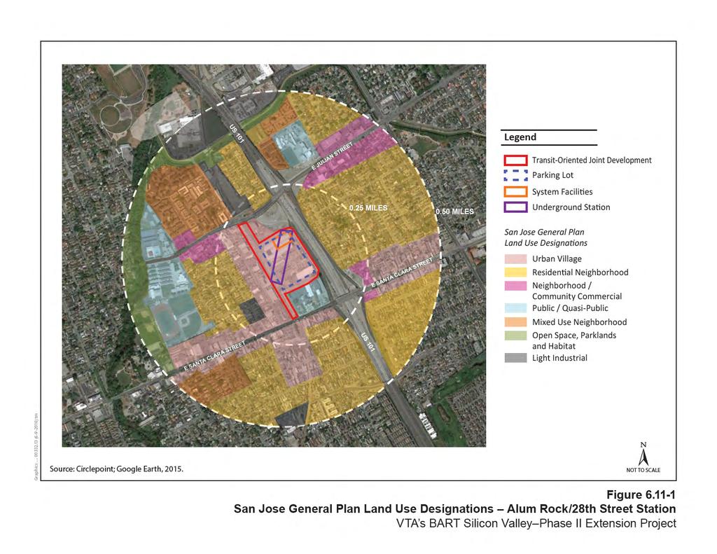
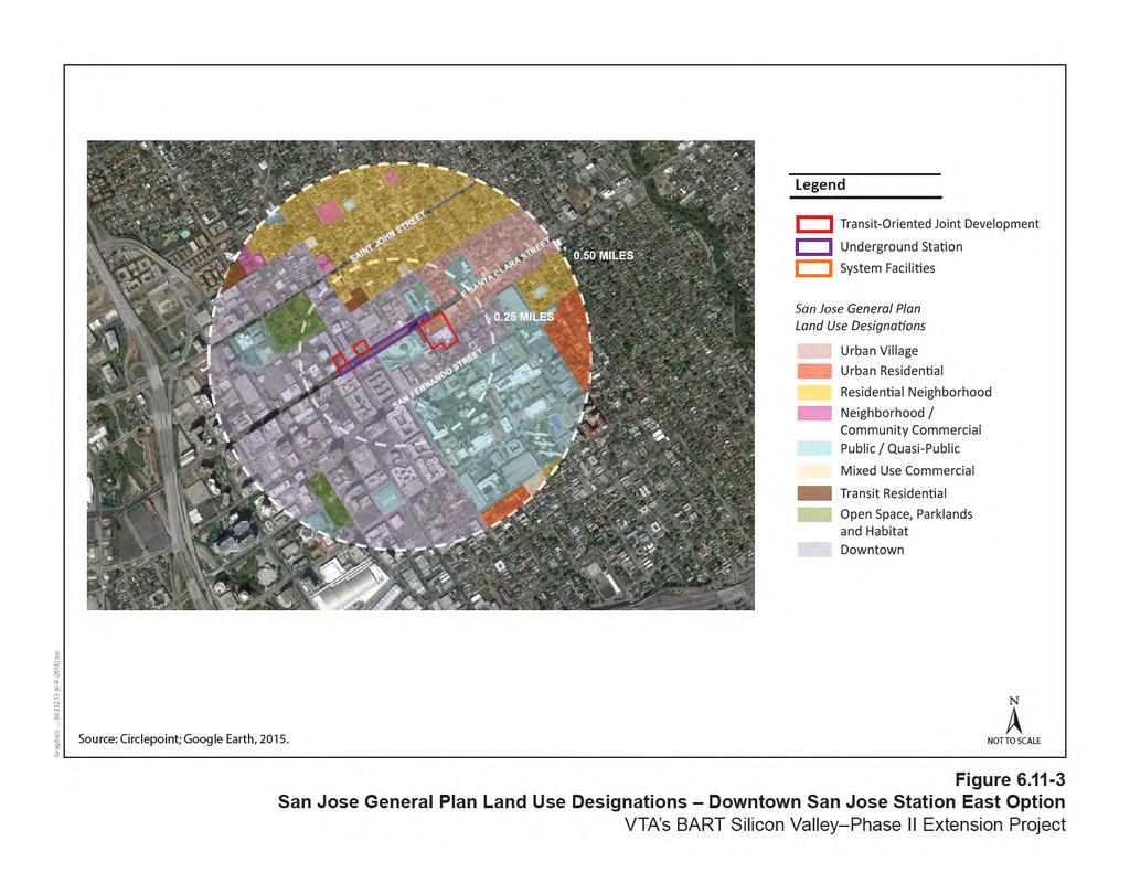
25 Station Locations Alum Rock/28 th Street Station Existing land uses within the Alum Rock/28 th Street Station area were described in Section , Environmental Setting. The station is surrounded by a mix of industrial, commercial, institutional/civic, and residential land uses that operate independently from each other. Alum Rock/28 th Street Station would replace existing industrial buildings but would not create new physical barriers within the community or divide an existing neighborhood. This station would increase the availability of transit options and allow for enhanced mobility for the surrounding neighborhoods. Therefore, the impact would be less than significant, and no mitigation is required. Downtown San Jose Station (East and West Options) Land uses surrounding both Downtown San Jose Station Options were described in Section Both station options would have limited aboveground infrastructure. The aboveground features would be designed to blend with the existing urban fabric of the downtown area and would not create a new barrier or substantially interrupt the community interaction in the area. Furthermore, operation of the Downtown San Jose Station would not divide any existing established community in the area. Operation of a station in downtown San Jose would increase the availability of transit options and allow for enhanced mobility for surrounding neighborhoods. Therefore, the impact would be less than significant, and no mitigation is required. Diridon Station (South and North Options) Existing land uses within the Diridon Station South and North Option areas were described in Section The aboveground infrastructure would include station entrance portals, systems facilities, and the reconfigured Diridon Station Bus Transit Center. These features would not create a new barrier or substantially interrupt the community interaction in the area. Additionally, the aboveground station features would be consistent with the existing transportation land uses in the station area. As previously discussed, one single-family residence would be displaced with implementation of the Extension at Diridon Station (South and North Options). However, the one single-family home displacement would occur in accordance with state and federal laws, the owner would be compensated appropriately, and the removal of one residence within a non-residential and predominantly industrial neighborhood would not cause or contribute to the physical division of a community; therefore, a less-than-significant impact would result. Refer to Section 4.14, Socioeconomics, for more information related to this displacement. Operation of either the Diridon Station South or North Option would not physically divide an existing established community. Furthermore, implementation of this station would increase the availability of transit options and allow for enhanced mobility for surrounding neighborhoods. Therefore, the impact would be less than significant, and no mitigation is required
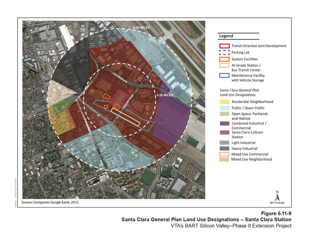
26 Santa Clara Station Existing land uses within the Santa Clara Station area were described in Section Santa Clara Station would be at the end of a cul-de-sac in an area surrounded by industrial and commercial/retail uses. In addition, the closest residences are to the west across the existing railroad corridor. Therefore, the station would not divide an existing community or put up barriers between any existing neighborhoods. The Extension would also construct the final segment of the Santa Clara Pedestrian Undercrossing, which would allow for pedestrians and cyclists to travel between El Camino Real and the Santa Clara Caltrain Station in the west directly to Brokaw Road and Coleman Avenue in the east. Furthermore, operation of this station would increase the availability of transit options for residents, retail employees, and shoppers, and allow for enhanced mobility for surrounding neighborhoods. Therefore, the impact would be less than significant, and no mitigation is required. Newhall Maintenance Facility Existing land uses surrounding the Newhall Maintenance Facility were described in Section Given that the maintenance facility would be within the existing railroad corridor, would be farther from the residences than the active rail corridor, and would be separated from the residential uses by existing 10- to 12-foot-high soundwalls, the Newhall Maintenance Facility would not significantly affect or divide an existing community, create new physical barriers, or substantially interrupt existing community interaction in the area. Therefore, the impact would be less than significant, and no mitigation is required. System Facilities Existing land uses surrounding the systems facilities are described in Section Supporting facilities would be contained within system facility sites, limited in size, and located along the alignment, within station areas, and often underground. The two mid-tunnel ventilation facilities, one at the northwest corner of Santa Clara and 13 th Streets and another east of Stockton Avenue south of Taylor Street, would be aboveground structures housing the equipment required to ventilate the tunnel and would be the same under both the Twin-Bore and Single-Bore Options. Land uses surrounding the site of the 13 th Street ventilation facility include commercial and residential uses. Commercial, residential, and industrial land uses surround the Stockton Avenue ventilation facility site options. Neither of the system facility sites would replace any community facilities, take any roads out of the existing roadway system, or physically divide an established community. In addition, both system facility sites would be designed to be aesthetically compatible with the surrounding existing uses. Therefore, the impact would be less than significant, and no mitigation is required
27 Impact Extension LU-2: Conflict with a land use plan, policy, or regulation intended to reduce an environmental effect Construction and Operation Construction of the Extension would occur within dense urban settings surrounded by a mix of land uses including industrial, commercial, retail, civic/institutional, and residential uses. Construction can be expected to occur within any part of the footprint identified on the station plans, plans and profiles, and CSAs. As previously discussed, VTA s transportation facilities are exempt from local land use regulations; therefore, the Extension is exempt from City planning regulations. Although VTA s transportation facilities are not subject to local land use regulations, a consistency analysis has been provided below. To reduce construction-related impacts, such as access disruption and traffic congestion, on adjacent land uses and communities, the unique characteristics of each area would be taken into consideration during construction planning and scheduling, and access would be maintained to the extent feasible. Construction planning would minimize nighttime construction in residential areas to the extent feasible. Potential construction-period traffic impacts and associated minimization measures are discussed in Section 6.2, Transportation. Additionally, construction activities could result in temporary impacts related to construction noise, degraded air quality, and lighting. Potential air quality, noise, and vibration impacts during construction and associated avoidance and minimization measures are discussed in Section 6.3, Air Quality, and Section 6.12, Noise and Vibration, respectively. Light and glare impacts on residential properties that could result from nighttime construction are addressed in Section 6.14, Visual Quality and Aesthetics. Once operational, the majority of the alignment would be underground and, therefore, would not conflict with land use plans, policies, or regulations intended to reduce the severity of an environmental effect. Aboveground features would include facilities at the four stations, two mid-tunnel ventilation facilities, and two tunnel portals. Station facilities would include parking structures at Alum Rock/28 th Street and Santa Clara Stations, station entrance portals, signage for underground stations (Alum Rock/28 th Street, Downtown San Jose, and Diridon Stations), and system facility sites. Aboveground facilities at the mid-tunnel ventilation sites would include buildings to house the ventilation structure and associated systems facilities. Aboveground facilities at the tunnel portals would be minimal
28 As shown in Tables and , the Extension would be consistent with general plan land use designations and applicable specific plans. The Extension would be partially consistent with 14 of the land use policies in San Jose and Santa Clara, as shown in Table This is because these 14 land use policies support the inclusion of mixed-use developments into new project development. The Extension would encourage future mixed-use development, but would not include mixed-use developments within its scope. The Extension would be fully consistent with the remaining 55 land use policies shown in Table The 13 th Street ventilation structure, the Downtown San Jose Station East and West Options, and the Stockton Avenue ventilation facility would be consistent with the existing City of San Jose zoning for their respective locations. The following Extension sites are currently zoned by their respective cities as Light and Heavy Industrial. Alum Rock/28 th Street Station (San Jose) Diridon Station (San Jose) Santa Clara Station (Santa Clara) A Light and Heavy Industrial designation permits only certain types of industrial uses in San Jose and Santa Clara and does not allow for non-industrial uses within either City. Additionally, the SJGP contains policies related to industrial preservation. policy 6.1 specifically prohibits the conversion of lands designated for light and heavy industrial uses to non-industrial uses and prohibit lands designated for industrial uses and mixed industrial-commercial uses to be converted to non-employment uses. However, as shown in Tables and , Alum Rock/28 th Street Station would be consistent with the Five Wounds Urban Village Plan, the Diridon Station South and North Options would be consistent with the Diridon Station Area Plan and Diridon/Arena Strategic Development Plan, and Santa Clara Station would be consistent with the Santa Clara Station Area Plan. The plans mentioned above were developed by the cities with extensive public outreach and involvement. The existing industrial zoning designations at the Alum Rock/28 th Street, Diridon, and Santa Clara Stations are currently outdated and inconsistent with the cities adopted plans and general plan designations. The cities, and the communities surrounding these three stations, support and expect stations to be constructed at these locations. Therefore, by rezoning the three station sites listed above, VTA would bring the zoning designations into alignment with both the general plan designation of these sites and with the vision of the cities and communities. The Extension would be consistent with the regional plans of MTC, Association of Bay Area Governments, VTA, and, and would enhance transit service to the South Bay, support the creation of a unified transit system that encircles the Bay, and encourage higher-density, mixed-use development adjacent to proposed transit stations. Therefore, the Extension would not conflict with any land use plan, policy, or regulation, and the impact would be less than significant. No mitigation is required
4.11 Land Use Introduction Environmental and Regulatory Setting Environmental Setting
 4.11 4.11.1 Introduction This section describes the affected environment and environmental consequences related to land use from operations of the NEPA Alternatives. Information regarding land use and
5.9 LAND USE INTRODUCTION METHODOLOGY
 5.9 LAND USE 5.9.1 INTRODUCTION An adverse effect on land use would occur if the alternatives physically divide an established community; change land use in a manner that would be incompatible with surrounding
Chapter 4. Linking Land Use with Transportation. Chapter 4
 Chapter 4 Linking Land Use with Transportation Chapter 4 59 Chapter 4 Linking Land Use with Transportation Community Design and Transportation Program Introduction Since the 1950s, the predominant development
The transportation system in a community is an
 7 TRANSPORTATION The transportation system in a community is an important factor contributing to the quality of life of the residents. Without a sound transportation system to bring both goods and patrons
Silverdale Regional Center
 Silverdale Regional Center Vision for Silverdale Regional Center The Silverdale Regional Center Plan (Plan) will guide the evolution of the Silverdale Regional Center from a collection of strip malls and
CHAPTER 7: Transportation, Mobility and Circulation
 AGLE AREA COMMUNITY Plan CHAPTER 7 CHAPTER 7: Transportation, Mobility and Circulation Transportation, Mobility and Circulation The purpose of the Transportation, Mobility and Circulation Chapter is to
EXISTING COMPREHENSIVE PLAN
 EXISTING COMPREHENSIVE PLAN Town Center Land Use Element: V. LAND USE POLICIES Town Center Mercer Island's business district vision as described in "Your Mercer Island Citizen-Designed Downtown" was an
New land uses or changes to existing land uses in the Phase 1 area since certification of the FEIR and SEIR-1 are discussed below for each city.
 4.12 LAND USE 4.12.1 INTRODUCTION This section provides relevant updates to information presented in the FEIR and SEIR-1 related to land use and the consistency of Phase 1 with local and regional planning
A. WHAT IS A GENERAL PLAN?
 I. Introduction A. WHAT IS A GENERAL PLAN? A general plan is the planning guideline for the future of a city. It contains goals and policies which regulate urban development, the protection of the natural
Policies and Code Intent Sections Related to Town Center
 Policies and Code Intent Sections Related to Town Center The Town Center Vision is scattered throughout the Comprehensive Plan, development code and the 1994 Town Center Plan. What follows are sections
Chapter 1.0 Introduction
 Chapter 1.0 Introduction 1.1 Background The North Metro commuter rail line is part of the RTD FasTracks regional transit system expansion program to build more than 100 miles of rail transit throughout
DRAFT Land Use Chapter
 Stevens Creek Urban Village DRAFT 1 18 17 Land Use Chapter INTRODUCTION This Land Use Chapter describes how the Stevens Creek Urban Village will accommodate the growth that is planned for it in the Envision
6.14 Visual Quality and Aesthetics
 6.14 6.14.1 Introduction This section describes impacts under CEQA that would result from construction and operation of the CEQA Alternatives. 6.14.1.1 Regulatory Setting State There are no federal or
SAN RAFAEL GENERAL PLAN 2040 INTRODUCTION AND OVERVIEW
 SAN RAFAEL GENERAL PLAN 2040 INTRODUCTION AND OVERVIEW Steering Committee Presentation February 14, 2018 Purpose of General Plan Guide land use and development decisions Coordinate transportation, infrastructure,
EXHIBIT A. Tax Increment Reinvestment Zone No. 1 (Town Center) First Amended Project Plan 1
 First Amended Project Plan 1") EXHIBIT A Tax Increment Reinvestment Zone No. 1 (Town Center) First Amended Project Plan 1 1 As amended by Resolution No. 2008-02-001(TR1R) of the Tax Increment Reinvestment Zone No.1, and approved to
EXHIBIT A Tax Increment Reinvestment Zone No. 1 (Town Center) First Amended Project Plan 1 1 As amended by Resolution No. 2008-02-001(TR1R) of the Tax Increment Reinvestment Zone No.1, and approved to
Chapter 1: Introduction
 Chapter 1: Introduction The Penn Avenue Community Works Corridor Vision and Implementation Framework presents an integrated communitybased vision and a coordinated, long-term implementation framework for
CHAPTER 1. Ms. Guajardo s Class - Central Elementary CH 1 1
 INTRODUCTION CHAPTER 1 Ms. Guajardo s Class - Central Elementary CH 1 1 1.1 SETTING South Centre City is a linear corridor south of Downtown Escondido paralleling Centre City Parkway and South Escondido
Town Center (part of the Comprehensive Plan)
") Town Center (part of the Comprehensive Plan) Mercer Island Town Center Looking North (2014) In 1994, a year-long process culminated in a set of design guidelines and code requirements for the Town Center
Town Center (part of the Comprehensive Plan) Mercer Island Town Center Looking North (2014) In 1994, a year-long process culminated in a set of design guidelines and code requirements for the Town Center
The University District envisions, in its neighborhood
 Envisioning the University District Link Light Rail in Seattle s neighborhoods CIY OF SEALE CONCEP-LEVEL SAION AREA PLANNING RECOMMENDAION RESOLUION # 30165 EXHIBI L Vision 08.2000 he University District
Transportation. Strategies for Action
 Transportation A major priority for the Overlake Neighborhood is to develop a multimodal transportation system. To achieve this system, a balance has to be found among travel, circulation and access needs;
Isabel Neighborhood Plan: Alternatives
 Isabel Neighborhood Plan: Alternatives Presented by: Lori Parks, Associate Planner February 2, 2015 Agenda 1. Background on BART to Livermore 2. Isabel Neighborhood Plan 3. Alternative Scenarios 4. General
Implementation Guide Comprehensive Plan City of Allen
 Implementation Guide 2030 Comprehensive Plan City of Allen DRAFT 2015 Implementation Guide Allen 2030 Comprehensive Plan INTRODUCTION The Comprehensive Plan serves as a guide for the growth and development
TOD 101 CREATING LIVABLE COMMUNITIES WITH TRANSIT
 1 CREATING LIVABLE COMMUNITIES WITH TRANSIT What are transit Centered Communities? Benefits of Partnerships to Support and Implement What You Will Learn Portland s Pearl District Your Trainers Today Catherine
3. VISION AND GOALS. Vision Statement. Goals, Objectives and Policies
 Vision Statement Queen Creek s interconnected network of parks, trails, open spaces and recreation opportunities provide safe and diverse activities and programs that sustain its unique, small town, equestrian
PSRC REVIEW REPORT & CERTIFICATION RECOMMENDATION
 PSRC REVIEW REPORT & CERTIFICATION RECOMMENDATION KITSAP COUNTY COUNTYWIDE PLANNING POLICIES July 2, 2012 BACKGROUND A major emphasis of the Washington State Growth Management Act (GMA) is the need to
13 THORNHILL YONGE STREET STUDY IMPLEMENTATION CITY OF VAUGHAN OPA 669 AND TOWN OF MARKHAM OPA 154
 13 THORNHILL YONGE STREET STUDY IMPLEMENTATION CITY OF VAUGHAN OPA 669 AND TOWN OF MARKHAM OPA 154 The Planning and Economic Development Committee recommends the adoption of the recommendations contained
Chapter Master Planned Communities (MPC) District
 District") Sections 14.53.010 Purpose and Intent 14.53.020 Applicability 14.53.030 Procedure 14.53.040 MPC Standards 14.53.050 Required Findings 14.53.010 Purpose and Intent Chapter 14.53 Master Planned Communities
Sections 14.53.010 Purpose and Intent 14.53.020 Applicability 14.53.030 Procedure 14.53.040 MPC Standards 14.53.050 Required Findings 14.53.010 Purpose and Intent Chapter 14.53 Master Planned Communities
Hockessin Community Redevelopment Plan
 Hockessin Community Redevelopment Plan 3.1 Introduction The Community Redevelopment Plan for the Village of Hockessin is the result of the people s vision for a distinct village center that serves as the
Corridor Vision. 1Pursue Minnehaha-Hiawatha Community Works Project. Mission of Hennepin County Community Works Program
 1Pursue Minnehaha-Hiawatha Community Works Project Minnehaha-Hiawatha Community Works is a project within the Hennepin Community Works (HCW) program. The mission of the HCW program is to enhance how the
Comprehensive Plan ADOPTED APRIL 2014
 Comprehensive Plan ADOPTED APRIL 2014 8 8. Outstanding Recreational & Cultural Opportunities We are proud of our community s parks and recreation system. Our community will ensure that the legacy of our
S A C R A M E N T O C O U N T Y JACKSON HIGHWAY & GRANT LINE EAST VISIONING STUDY
 JACKSON HIGHWAY & GRANT LINE EAST S A C R A M E N T O C O U N T Y P L A N N I N G D E P A R T M E N T SUMMARY AND WORKBOOK November 19, 2008 History of the Visioning Study Sacramento County has two growth
Gold Line Bus Rapid Transit Transit Oriented Development (BRTOD) Helmo Station Area Plan
 Helmo Station Area Plan") Appendix F Gold Line Bus Rapid Transit Transit Oriented Development (BRTOD) Helmo Station Area Plan Introduction and Purpose of the Plan The Gold Line Bus Rapid Transit facility is an eleven-mile dedicated
Appendix F Gold Line Bus Rapid Transit Transit Oriented Development (BRTOD) Helmo Station Area Plan Introduction and Purpose of the Plan The Gold Line Bus Rapid Transit facility is an eleven-mile dedicated
1.0 VISION STATEMENT. December 6, PRINCIPLES
 Vision Statement Lincoln Regional Airport 1.0 VISION STATEMENT 1.1 City LOCATION of AND OVERVIEW The Easton Lincoln Place Land Use Master Plan identifies the principles, goals, policies, and standards
III. Design Principles
 III. Design Principles The design of Bay Meadows Phase II has been guided by a series of Urban Design Principles. These principles, informed by consultant site analysis, City staff recommendations, and
THE GARDEN CITY PLAN. City of St. Catharines Official Plan. City of St. Catharines
 THE GARDEN CITY PLAN City of St. Catharines Official Plan City of St. Catharines August 2010 APPROVAL INFORMATION This Official Plan of the City of St. Catharines Planning Area, known as the Garden City
Developer s Program. The Station at East 54
 Developer s Program The Station at East 54 Existing Conditions The Station at East 54 is proposed for a 1.12 acre site at the northeast corner of Hamilton Road and Prestwick Road, tucked between the East
Concord Community Reuse Project Goals and Guiding Principles. Overarching Goals (OG)
") Concord Community Reuse Project Goals and Guiding Principles Overarching Goals (OG) No priority is implied by the order of presentation of the goals and guiding principles. Overarching goals for the Concord
Concord Community Reuse Project Goals and Guiding Principles Overarching Goals (OG) No priority is implied by the order of presentation of the goals and guiding principles. Overarching goals for the Concord
CITY OF CHARLOTTESVILLE, VIRGINIA CITY COUNCIL AGENDA
 CITY OF CHARLOTTESVILLE, VIRGINIA CITY COUNCIL AGENDA Agenda Date: December 16, 2013 Action Required: Adoption of Resolution Presenter: Staff Contacts: Title: James E. Tolbert, AICP, Director of NDS James
Diridon Station Area: Framework for Implementation
 Diridon Station Area: Framework for Implementation LAND USE MISSION: The Diridon Station Area is the most significant opportunity for placemaking in San Jose. Development should integrate and expand into
Key Concepts of the General Plan
 Key Concepts of the General Plan General Plan Purpose Vision for City s future Standards for City Services Land Use Plan General Plan Purpose San Jose is creating its Blueprint for the Future to become
4.16 Visual Quality and Aesthetics
 4.16 4.16.1 Introduction This section describes the affected environment and environmental consequences related to visual quality and aesthetics from operations of the NEPA Alternatives. Information regarding
Atlanta BeltLine Corridor Environmental Study. Scoping Meeting August 2008
 Atlanta BeltLine Corridor Environmental Study Scoping Meeting August 2008 What Will We Be Discussing Today? Study Overview - How Did We Get Here? - What Is the Study About? - Who Is Involved? - Where Is
Executive Summary. NY 7 / NY 2 Corridor
 Executive Summary NY 7 / NY 2 Corridor Transportation and Land Use Study December 2005 Prepared for: Town of Colonie Capital District Transportation Committee Prepared by: Introduction: Land use decisions
The Five Components of the McLoughlin Area Plan
 The Five Components of the McLoughlin Area Plan This documents contains the complete language of the five components of the McLoughlin Area Plan: The Vision Statement The Values The Guiding Principles
4. ENVIRONMENTAL IMPACT ANALYSIS 7. LAND USE AND PLANNING
 4. ENVIRONMENTAL IMPACT ANALYSIS 7. LAND USE AND PLANNING 4.7.1 INTRODUCTION The following analysis discusses the consistency of the Proposed Project with the corresponding land use and zoning designations
Mississippi Skyway Preliminary Engineering Report
 EXECUTIVE SUMMARY Mississippi Skyway Preliminary Engineering Report CITY OF RAMSEY, MINNESOTA DECEMBER 2014 City of RAMSEY EXECUTIVE SUMMARY Project Need and Intent The Mississippi Skyway pedestrian bridge
TRANSPORTATION ELEMENT GOALS, OBJECTIVES, AND POLICIES
 TRANSPORTATION ELEMENT GOALS, OBJECTIVES, AND POLICIES GOAL 2 The City shall provide a safe, convenient, effective, and energy efficient multimodal transportation system which is coordinated with the Future
Horizon 2035 Land Use and Transportation Element
 CITY OF SUNNYVALE Horizon 2035 Land Use and Transportation Element City Council Study Session March 7, 2017 Overview General Plan Context Mixed Use Villages Transportation Mode & Parking General Plan Policy
The Role of Cities in Planning Transportation Megaprojects
 The Role of Cities in Planning Transportation Megaprojects SPUR Oakland, November 28, 2018 + Elizabeth Deakin / UC Berkeley + Eric Eidlin / City of San Jose + Doug Johnson / City of San Francisco The Role
TRANSIT ORIENTED DEVELOPMENT PINELLAS COUNTY MPO LIVABLE COMMUNITIES INITIATIVE PINELLAS COUNTY COMPREHENSIVE PLAN AMENDMENTS
 PINELLAS COUNTY MPO LIVABLE COMMUNITIES INITIATIVE MODEL LAND DEVELOPMENT CODE TRANSIT ORIENTED DEVELOPMENT PINELLAS COUNTY COMPREHENSIVE PLAN AMENDMENTS MPO Livable Communities Initiative Goal: Improve
38 Queen s University Campus Master Plan Part 1
 38 Queen s University Campus Master Plan Part 1 46 The Campus at the City Scale Chapter 4 The Campus at the City Scale 39 Queen s is an urban University centrally located in Kingston. Decisions made by
Cumberland Region Tomorrow is a private, non-profit, citizen based regional organization working with Greater Nashville Regional Council
 Cumberland Region Tomorrow is a private, non-profit, citizen based regional organization working with Greater Nashville Regional Council and others in the public and private sectors, dedicated to planning
RESOLUTION NO. R Refining the route, profile and stations for the Downtown Redmond Link Extension
 RESOLUTION NO. R2018-32 Refining the route, profile and stations for the Downtown Redmond Link Extension MEETING: DATE: TYPE OF ACTION: STAFF CONTACT: Capital Committee Board PROPOSED ACTION 09/13/2018
Public input has been an important part of the plan development process.
 Lakewood s Comprehensive Plan recognizes that transportation helps shape the community, and that the way the community provides for the safe and efficient movement of people affects the character of the
City of Hermosa Beach Administrative Policy #
 City of Hermosa Beach Administrative Policy # SUBJECT: Living Streets Policy Date: Approved by: City Council Authority: Public Works Department & Community Development Department Mayor, PURPOSE The City
Plano Tomorrow Vision and Policies
 Plano Tomorrow Vision and Policies PLANO TOMORROW PILLARS The Built Environment The Social Environment The Natural Environment The Economic Environment Land Use and Urban Design Transportation Housing
V. Vision and Guiding Principles
 V. Vision and Guiding Principles The Master Plan for the Powers Ferry Corridor seeks a foundation in the desires of the community. At times, various elements of the community offered opposing viewpoints,
MONTGOMERY COUNTY METRO STATION AREA DESIGN CHARRETTE
 MONTGOMERY COUNTY METRO STATION AREA DESIGN CHARRETTE Shady Grove Metro Station Area Charrette Closing Presentation October 25-28, 2000 MONTGOMERY COUNTY, MD M-NCPPC Design Collective, Inc. Architects
TRANSIT-ORIENTED DEVELOPMENT POLICY DRAFT. City Planning and Development Department Kansas City, Missouri
 TRANSIT-ORIENTED DEVELOPMENT POLICY DRAFT City Planning and Development Department Kansas City, Missouri What is Transit Oriented Development (TOD)? Development that focuses land uses around a transit
A BLUEPRINT FOR BROCKTON A CITY-WIDE COMPREHENSIVE PLAN
 A BLUEPRINT FOR BROCKTON A CITY-WIDE COMPREHENSIVE PLAN Public Meeting October 2016 1 Plan Summary and Discussion Public Meeting May 4 2017 City of Brockton Bill Carpenter, Mayor Department of Planning
CHARLES PUTMAN CHARLES PUTMAN AND ASSOCIATES, INC
 MEMORANDUM CHARLES PUTMAN & ASSOCIATES, INC. LAND DEVELOPMENT CONSULTANTS PLANNING ZONING PERMITTING 4722 NW Boca Raton Boulevard, Suite C-106 Boca Raton, Florida 33431 Phone: 561/994-6411 FAX: 561/994-0447
Mobility Districts and Traffic Studies
 Mobility Districts and Traffic Studies During the last Comprehensive Plan update in 2008, the City of Sarasota identified the need to develop a citywide strategy for enhancing the mobility options of all
TREASURE COAST REGIONAL PLANNING COUNCIL M E M O R A N D U M. To: Council Members AGENDA ITEM 5H
 TREASURE COAST REGIONAL PLANNING COUNCIL M E M O R A N D U M To: Council Members AGENDA ITEM 5H From: Date: Subject: Staff October 17, 2008 Council Meeting Local Government Comprehensive Plan Review Draft
Urban Planning and Land Use
 Urban Planning and Land Use 701 North 7 th Street, Room 423 Phone: (913) 573-5750 Kansas City, Kansas 66101 Fax: (913) 573-5796 Email: planninginfo@wycokck.org www.wycokck.org/planning To: From: City Planning
Establish a network of streetscaped vehicle and pedestrian routes that connect within and outside the Plan area.
 This Plan s urban design goals are to create an urban scale, walkable community with connections to transit, parks, and services and with amenities and facilities for residents and employees. The 1992
WELCOME and introduction
 1 WELCOME and introduction Mobility Hub Locations within Burlington STUDY OVERVIEW STUDY OBJECTIVES The City of Burlington is developing four Area Specific Plans, one for each of Burlington s Mobility
ARLINGTON COUNTY, VIRGINIA
 ARLINGTON COUNTY, VIRGINIA County Board Agenda Item Meeting October 15, 2005 DATE: September 28, 2005 SUBJECT: Request to Advertise the adoption of the 2005 Clarendon Sector Plan C. M. RECOMMENDATION:
Urban Design Manual PLANNING AROUND RAPID TRANSIT STATIONS (PARTS) Introduction. Station Study Areas
 Introduction. Station Study Areas") 111111 PLANNING AROUND RAPID TRANSIT STATIONS (PARTS) Introduction The ION rapid transit system will link Waterloo, Kitchener and Cambridge through a central transit corridor (CTC). There are a number
111111 PLANNING AROUND RAPID TRANSIT STATIONS (PARTS) Introduction The ION rapid transit system will link Waterloo, Kitchener and Cambridge through a central transit corridor (CTC). There are a number
3.0 PROJECT DESCRIPTION
 3.0 PROJECT DESCRIPTION 3.1 BACKGROUND Under California law (Government Code Section 65300 et seq.), every city and county is required to have a general plan. The general plan is to be comprehensive and
PLAN ELEMENTS WORKSHOP. April 5, 2016
 PLAN ELEMENTS WORKSHOP April 5, 2016 needs more housing. But there is no one-size fits-all solution. Every neighborhood has its own character. In some places, density is not only appropriate it is badly
6. DOWNTOWN. The Downtown Element focuses on supporting and expanding the vitality and enhancement of Downtown Chico as the City s central core.
 VISION In 2030, Downtown Chico is the heart of the community and the center of cultural activity. Engaging and active at the street level, it is a multi-story, mixed-use hub, with specialty retail, restaurants,
The West Vaughan Employment Area Secondary Plan Policies
 Part 2: The West Vaughan Employment Area Secondary Plan Policies 2.1 General Policies It is the policy of Council: 2.1.1. That the West Vaughan Employment Area (the WVEA), identified on Schedule 1, will
Midtown Greenway Land Use and Development Plan Executive Summary
 Midtown Greenway Land Use and Development Plan Executive Summary Introduction The Midtown Greenway Land Use and Development Plan sets policy direction for land use and development in the Midtown Greenway
6. Consistency with Local Plans
 6. Consistency with Local Plans 6.1. Chapter Overview 6.1.1. Introduction This section presents the goals, objectives and policies of municipal, county and state planning entities, as well as known development/redevelopment
178 Carruthers Properties Inc.
 178 Carruthers Properties Inc. Planning Rationale for 178 Carruthers Avenue Site Plan Control Application June 2014 Table of Contents 1.0 Introduction 2.0 Overview of Subject Property 3.0 Current Zoning
CITY COUNCIL AGENDA REPORT
 CITY COUNCIL AGENDA REPORT Subject: COUNCIL MOTION LRT ALIGNMENT REMOVAL FROM THE TRANSPORTATION MASTER PLAN On February 10, 2016 Councillor Hughes provided notice in accordance with Section 23 of Procedure
C. Westerly Creek Village & The Montview Corridor
 C. Westerly Creek Village & The VISION Community Vision When the goals of the city are achieved Westerly Creek Village, a distinctive community defined by Montview Boulevard and Westerly Creek, is a strong
Living in Albemarle County s Urban Places
 Living in Albemarle County s Urban Places ALBEMARLE COUNTY, VIRGINIA A Closer Look at Albemarle s Approach to Managing Growth and Creating Quality Urban Environments www.albemarle.org Page 2 Living in
4.1.3 LAND USE CATEGORIES
 4.1.3 LAND USE CATEGORIES a. City Center District The City Center District incorporates the existing character and mix of uses in downtown Belmont to encourage redevelopment and new development in keeping
Visioning Statement and Guiding Principles
 Visioning Statement and Guiding Principles Planning for the Future The General Plan The General Plan represents Woodland's shared vision of the future and defines a path to lead the community toward its
Transportation Working Team Duane Diggs, Co-Chair (VOICE Buffalo) Kelly Dixon, Co-Chair (GBNRTC) Paul Ray, Facilitator (UB Regional Institute)
 Kelly Dixon, Co-Chair (GBNRTC) Paul Ray, Facilitator (UB Regional Institute)") towards a more sustainable Buffalo Niagara Transportation Working Team Duane Diggs, Co-Chair (VOICE Buffalo) Kelly Dixon, Co-Chair (GBNRTC) Paul Ray, Facilitator (UB Regional Institute) Agenda Welcome,
towards a more sustainable Buffalo Niagara Transportation Working Team Duane Diggs, Co-Chair (VOICE Buffalo) Kelly Dixon, Co-Chair (GBNRTC) Paul Ray, Facilitator (UB Regional Institute) Agenda Welcome,
4.13 Security and System Safety
 4.13 4.13.1 Introduction This section describes the affected environment and environmental consequences related to security and system safety from operations of the NEPA Alternatives. Information regarding
EXECUTIVE SUMMARY DRAFT CHAPTER 1 INTRODUCTION EXECUTIVE SUMMARY
 CHAPTER 1 EXECUTIVE SUMMARY INTRODUCTION Through the joint efforts of the City of Tulsa planning staff and the Land Services division of Indian Nations Council of Governments (INCOG), the Berryhill Land
CHAPTER 3 VISION, GOALS, & PLANNING PRINCIPLES. City of Greensburg Comprehensive Plan. Introduction. Vision Statement. Growth Management Goals.
 CHAPTER 3 VISION, GOALS, & PLANNING PRINCIPLES Introduction The Greensburg Comprehensive Plan is intended as a working community document. A combination of long and short-term goals, this document is intended
BROOKLYN PARK / 85TH AVE LRT STATION CDI DEVELOPMENT GUIDELINES DRAFT
 August 2018 Page intentionally left blank The Brooklyn Park Library adjacent to the 85th Ave LRT Station Area. OVERVIEW The Blue Line LRT Extension / Bottineau corridor offers a unique opportunity to leverage
ELK GROVE GENERAL PLAN VISION
 2-1 CHAPTER 2: 2-2 CREATING OUR The Community Vision for Elk Grove, expressed through a Vision Statement and a series of Supporting Principles, is a declaration of the kind of community that Elk Grove
CHAPTER 7: VISION AND ACTION STATEMENTS. Noble 2025 Vision Statement
 CHAPTER 7: VISION AND ACTION STATEMENTS This chapter presents the vision, policy and action statements that transform the comprehensive planning study, an analysis of Noble s past, future trends and community
Shift Rapid Transit Public Participation Meeting May 3, 2017
 Shift Rapid Transit Public Participation Meeting May 3, 2017 Shift Rapid Transit Initiative Largest infrastructure project in the city s history. Rapid Transit initiative will transform London s public
3.10 LAND USE SETTING PROJECT SITE EXISTING LAND USE DESIGNATIONS AND ZONING. General Plan Land Use Designations.
 This section of the Draft EIR addresses the existing land uses on and adjacent to the project site and discusses the potential impacts of the proposed project on existing land uses. Key issues addressed
1.0 Introduction. Purpose and Basis for Updating the TMP. Introduction 1
 1.0 Introduction The Town of Castle Rock is situated between the metropolitan areas of Denver and Colorado Springs, amidst a unique terrain of rolling hills, mesas, ravines, and waterways. Like many Front
LAND USE OVERVIEW WHAT YOU WILL FIND IN THIS CHAPTER
 LAND USE WHAT YOU WILL FIND IN THIS CHAPTER Information about the City s expected population and employment growth. Description and capacity of existing and future land use designations. Policies that
REZONING GUIDE. Zone Map Amendment (Rezoning) - Application. Rezoning Application Page 1 of 3. Return completed form to
 - Application. Rezoning Application Page 1 of 3. Return completed form to") Zone Map Amendment (Rezoning) - Application COMMUNITY PLANNING & DEVELOPMENT REZONING GUIDE Rezoning Application Page 1 of 3 PROPERTY OWNER INFORMATION* CHECK IF POINT OF CONTACT FOR APPLICATION Property
Zone Map Amendment (Rezoning) - Application COMMUNITY PLANNING & DEVELOPMENT REZONING GUIDE Rezoning Application Page 1 of 3 PROPERTY OWNER INFORMATION* CHECK IF POINT OF CONTACT FOR APPLICATION Property
Proposed Comprehensive Plan Strategies DRAFT for discussion June 28, 2017
 Proposed Comprehensive Plan Strategies DRAFT for discussion June 28, 2017 Land Use Rural Areas Refine the Farm and Forest area (FF) Update FF boundaries to account for existing lots less than five acres
IMPLEMENTING SOMERSET COUNTY S INVESTMENT FRAMEWORK
 IMPLEMENTING SOMERSET COUNTY S INVESTMENT FRAMEWORK SMART CONSERVATION THROUGH SMART GROWTH NJ LAND CONSERVATION RALLY March 22, 2014 Laurette Kratina, PP, AICP, Supervising Planner Somerset County Planning
DALY CITY VISIONING PROCESS COMMUNITY WORKSHOP 3 MAY 8, 2008
 DALY CITY VISIONING PROCESS COMMUNITY WORKSHOP 3 MAY 8, 2008 PROCESS General Plan - a statement of the community s values, vision and aspirations for now and into the future... Timeframe LONG TERM - 2030
4- PA - LD - LIVELY DOWNTOWN. LD - Background
 4- PA - LD - LIVELY DOWNTOWN LD - Background The downtown has been the service centre for the community since the city s inception and the area continues to supply people with their personal services,
1.0 Circulation Element
 5/9/18 1.0 Circulation Element 1.1 Introduction As growth and development occur in Apache County, enhancements to its circulation system will be necessary. With time, more roads will be paved and air and
12/9/2013. HOLLYWOOD/PINES CORRIDOR PROJECT AMPO 2013 Annual Conference October 24, Our Perspective. Broward.
 HOLLYWOOD/PINES CORRIDOR PROJECT AMPO 2013 Annual Conference October 24, 2013 Our Perspective Broward Fort Lauderdale 1 Broward Metropolitan Planning Organization Fort Lauderdale Fort Lauderdale Skyline
New Partners for Smart Growth Conference February 5, 2010
 Dan Stroh, Planning Director City of Bellevue Planning and Community Development Bellevue, WA New Partners for Smart Growth Conference February 5, 2010 Summary of Project Long-range plan update for Bel-Red
DENVER DESIGN DISTRICT GDP
 DENVER DESIGN DISTRICT GDP Urban Design Standards and Guidelines November 17, 2008 Amended February 3, 2016 City and County of Denver CF Property Management, Inc. C/O Denver Design District - Starboard