City of Valparaiso Pathways and Greenways Master Plan Update
|
|
|
- Maurice Ferguson
- 5 years ago
- Views:
Transcription


1 City of Valparaiso Pathways and Greenways Master Plan Update PREPARED BY: DECEMBER 2010
2
3 Pathways and Greenways Master Plan Final Report Acknowledgements Mayor Jon Costas Clerk-Treasurer Sharon Swihart City Administrator Bill Oeding City Council John Bowker Jan Dick Al Eisenmenger Art Elwood Joey Larr Bob Taylor Kelly Ward Park Board E. Ric Frataccia, President Debora Butterfield TJ Edwards Christa Emerson Borlick i
4 City of Valparaiso Table of Contents CHAPTER ONE - INTRODUCTION WHAT ARE PATHWAYS AND GREENWAYS DEFINITIONS USED IN THE UPDATED PATHWAYS AND GREENWAYS MASTER PLAN... 2 CHAPTER TWO - OVERVIEW OF THE UPDATED PATHWAYS AND GREENWAYS MASTER PLANNING PROCESS SITE ANALYSIS... 4 CHAPTER THREE - COMMUNITY INPUT CITIZEN SURVEY PRIORITIES KEY LEADERSHIP INTERVIEWS COMMUNITY INPUT MEETING CHAPTER FOUR - KEY COMPONENTS FROM THE 2005 PATHWAYS AND GREENWAY MASTER PLAN THAT NEED TO CONTINUE NEW PATHWAY AND GREENWAYS MASTER PLAN UPDATE RECOMMENDATIONS DEVELOPMENT OF A SPINE CONCEPT BRANDING AND SIGNAGE FOR THE PATHWAY SYSTEM DEVELOP PATHWAY AMENITIES FOR USERS OF THE SYSTEM PROGRAM THE USE OF PATHWAYS TO BUILD AWARENESS DEVELOP IMPROVED MAINTENANCE PRACTICES DEVELOP PARTNERSHIPS WITH COMMUNITY REGIONAL PATHWAYS DIRECTIVES WORKING WITH OTHER PLANNING AGENCIES CAPITAL IMPROVEMENT COSTS FUNDING OPTIONS CHAPTER FIVE - CONCLUSION ii

5 Pathways and Greenways Master Plan Final Report CHAPTER ONE - INTRODUCTION In 2005 Lehman and Lehman, Inc. developed the Pathways and Greenways Master Plan for the City of Valparaiso. The plan was approved and adopted in Much effort has been made by the City of Valparaiso, the Parks and Recreation Department and City Planning to develop portions of the Pathways Plan over the last five years. To date, 2 miles of pathways have been completed. As a part of the new 2010 Parks and Recreation Master Plan, the Director of the Parks and Recreation Department decided he would like to update the Pathways and Greenways Plan to coincide with the new Parks and Recreation Master Plan so the two plans are viewed as one document for coordination and capital improvement purposes. Most of the Pathways and Greenways Master Plan elements developed in 2005 will stay as a central focus point as written. Through further pathway assessment by PROS and Parks and Recreation Staff, as well as additional community input and analysis completed as part of the Parks and Recreation Master Plan, some changes to the 2005 document are necessary to carry the Pathways vision forward. The Parks and Recreation Master Plan will include this updated Pathways and Greenways Plan as an appendix with references to the 2005 Pathways and Greenways Master Plan document. 1.1 WHAT ARE PATHWAYS AND GREENWAYS Pathways and greenways are corridors of protected open space managed for conservation, recreation and alternative transportation purposes. Greenways often follow natural land or water features, and link nature areas, parks, schools, cultural features, destination places and historic sites with each other and with populated areas in the City. Greenways can be 1
6 City of Valparaiso publicly or privately owned and some are developed as a result of public/private partnerships. Pathways in Valparaiso are used for walking, bicycling, and running primarily. Currently, many of the pathways do not connect to parks, schools, downtown, neighborhoods, Valparaiso University and destination attractions in a continuous system which is the key focus of the Updated Pathways and Greenways Plan. The goal of the updated Pathways and Greenways Master Plan is to positively improve the impact that Pathways can provide to citizens in Valparaiso for health and wellness purposes, connectivity, ease of transportation from one site to another and for economic development purposes. The benefits of Pathways and Greenways include: Making communities better places to live by preserving and creating open spaces; Encouraging physical fitness and healthy lifestyles; Creating new opportunities for outdoor recreation and non-motorized transportation access to key destinations in the City; Strengthening the local economy; Connecting the community to schools, attractions and parks; Protecting the environment; and Preserving culturally and historically valuable areas in the City. 1.2 DEFINITIONS USED IN THE UPDATED PATHWAYS AND GREENWAYS MASTER PLAN Greenway: A linear open space that connects park components to form a cohesive park, recreation and open space area Connected Pathways System: A pathway trail system utilizing new sidewalks and trails to serve as connections to destinations such as schools, Downtown, neighborhoods and parks Conservation Corridor: A greenway corridor, generally along a water course, that has been identified as environmentally significant that can be protected through acquisition, conservation easements and public education Trail is designated as a 10 wide asphalt or concrete amenity surface Pathways are designated along streets primarily that are a 8 wide concrete offstreet amenity surface with key trail heads to access the trail and appropriate signage Sidewalk is a 5 wide concrete amenity alongside a street Off-street trail is an asphalt paved or impervious surface amenity that is typically 8 wide On- street trail is a 5 designated space on an existing street 2

7 Pathways and Greenways Master Plan Final Report Loop Trail is a 8 wide concrete or asphalt amenity surface that loops around a park or school to promote wellness and fitness primarily for neighborhood users Active Recreation: Recreational activities that require intense physical exercise such as bicycling and jogging Passive Recreation: Recreational activities that do not require intense physical exercise such as walking, bird watching and fishing Infrastructure: The underlying foundation of basic framework of a city, including streets, parks bridges, sewers, streetlights, sidewalks and other utilities 3
8 City of Valparaiso CHAPTER TWO - OVERVIEW OF THE UPDATED PATHWAYS AND GREENWAYS MASTER PLANNING PROCESS 2.1 SITE ANALYSIS PROS staff along with members of the Pathways Committee, Park and Recreation Department staff and Planning Department staff toured all the existing pathways in the system and future opportunities for pathways. The focus was to evaluate pathway access, standards, use, amenities, signage, connectivity and maintenance. The existing pathways assessment was made and is as follows: The pathways that are intact and in place are well designed at 8 width and are well used for walking and running primarily based on observations while touring the system Some bicycling by youth was occurring along the existing pathways in place when observed as part of the Pathways tour Currently there is limited way-finding signage in place that designates to users that they are on a designated pathway as well as there is limited safety signage along the pathways The pathways maintenance appeared to be maintained at a high level of care No graffiti was present along the pathways observed Trail head signage was lacking even though there are two trail head access points established along the trail with limited amenities Restrooms were available along the pathway at two parks in the system Limited pathway furniture such as park benches and water fountains were observed on the site tour along the pathways Security lighting was not in place at trail head locations nor safety response phones available Many of the pathways observed with the exception of Campbell Street are not connected to many destinations currently. The Campbell Street corridor is connected to four parks, two schools, and the Boys and Girls Club The Lincolnway Pathway is almost completed that ties the University of Valparaiso to Downtown and will open in September of 2010 which is well designed and lighted The other pathways observed that are in place were more connected to neighborhoods than to a major street corridor but was designed well and note signed as a pathway The elements of the pathways system that appear from the on-site pathway assessment that are designated as part of a linked system include the link on the north to south portions of the City from Rogers-Lakewood Park to Ogden Gardens as well as east and west portions of the city from Valparaiso University to Downtown on East Lincolnway street that are 4

9 Pathways and Greenways Master Plan Final Report connected as part of the existing Pathways Master Plan. The pathways tour team evaluated options that could be developed in a spine system to tie a system of linear corridors together by driving each potential spine corridor to determine how or if it could be connected, how much right-a-way the City owned and potential partners that could be involved in helping that particular pathway system to be further developed. The potential spine corridors reviewed included Vale Park Road (east to west), Glendale Blvd (east to west), Silhavy Road (north to south), East and West Lincolnway (east to west), Evans Ave (east to west), Roosevelt Road (north to south), County Road 150 E (north and south), South Washington Road (north to south), Calumet Ave (north to south), and Bullseye Lake Road (east to west). 5

10 City of Valparaiso CHAPTER THREE - COMMUNITY INPUT 3.1 CITIZEN SURVEY PRIORITIES The Master Plan for the Parks and Recreation Department included developing a random household citizen survey. The citizen survey indicated that Pathways and Greenway development was the number one amenity that the community desired NEED FOR PARKS AND RECREATION FACILITIES The parks and recreation facilities that the highest percentage of households have a need for are: connected walking and biking trails (63%), nature center and trails (61%), greenspace and natural areas (51%), indoor fitness and exercise facilities (47%), small neighborhood parks (47%), and indoor swimming pools/leisure pool (46%) (Figure 1). Figure 1 - Need for Parks and Recreation Facilities 6


11 Pathways and Greenways Master Plan Final Report NUMBER OF HOUSEHOLDS THAT HAVE A NEED FOR PARKS AND RECREATION FACILITIES From a list of 29 parks and recreation facilities, respondents were asked to indicate all of the ones for which members of their household have a need. Figure 2 shows the estimated number of households in the City of Valparaiso that have a need for various parks and recreation facilities, based on 12,605 households in the City. Figure 2 - Number of Households that Have a Need for Parks and Recreation Facilities HOW WELL PARKS AND RECREATION FACILITIES MEET NEEDS For all 29 parks/facilities, less than 55% of households with a need for parks/facilities feel that their needs are being completely met (Figure 3). Figure 3 - How Well Parks and Recreation Facilities Meet Needs 7


12 City of Valparaiso VALPARAISO HOUSEHOLDS WITH THEIR FACILITY NEEDS BEING 50% MET OR LESS From a list of 29 parks and recreation facilities, households that have a need for parks/facilities were asked to indicate how well these types of parks/facilities in the City of Valparaiso meet their needs. Figure 4 shows the estimated number of households in the City of Valparaiso whose needs for parks/facilities are only being 50% met or less, based on 12,605 households in the City. Figure 4 - Households with Their Facility Needs Being 50% Met or Less MOST IMPORTANT PARKS AND RECREATION FACILITIES Based on the sum of their top four choices, the parks and recreation facilities that are most important to households are: connected walking and biking trails (43%), outdoor swimming pool/family aquatic center (30%), nature center and trails (27%), small neighborhood parks (20%), and indoor fitness and exercise facilities (18%). It should also be noted that connected walking and biking trails had the highest percentage of households select it as their first choice as the most important park/ facility (Figure 5). Figure 5 - Most Important Parks and Recreation Facilities 8
13 Pathways and Greenways Master Plan Final Report 3.2 PRIORITIZED FACILITY NEEDS ASSESSMENT The purpose of the Facility Needs Assessment is to provide a prioritized list of facility/amenity needs for the residents of the City of Valparaiso. The Needs Assessment evaluates both quantitative and qualitative data. Quantitative data includes the statistically valid Community Survey, which asked 358 households located in the Valparaiso area to list unmet needs and rank their importance. Qualitative data includes resident feedback obtained in Focus Group meetings and Key Leader Interviews. A weighted scoring system was used to determine the priorities for parks and recreation facilities/amenities. For instance, as noted below, a weighted value of 3 for the unmet desires means that out of a total of 100%, a value of 30% would be attributed to unmet desires or support identified in the survey. This scoring system considers the following: Community Survey o o Unmet desires for facilities This is used as a factor from the total number of households mentioning whether they have a need for a facility and the extent to which their desires for facilities have been met. Survey participants were asked to identify their desire for or support of 29 different facilities. Weighted value of 3. Importance ranking for facilities This is used as a factor of the importance allocated to a facility by the community. Each respondent was asked to identify the top four most important facilities. Weighted value of 3. Consultant Evaluation o Factor derived from the consultant evaluation of facility priority based on survey results, demographics, trends and overall community input. Weighted value of 4. These weighted scores were then summed to provide an overall score and priority ranking for the system as a whole. The results of the priority ranking were tabulated into three categories: High Priority (1), Medium Priority (2), and Low Priority (3). The combined total of the weighted scores for Community Unmet Needs, Community Importance and Consultant Evaluation is the total score based on which the Facility/Amenity and is determined. Since this is a community-wide survey, it is obvious that amenities that benefit the widest demographic cross-sections of the community would tend to be ranked higher than those that serve a niche market. It is, therefore, typical in such assessments nationwide that broad categories, such as trails or neighborhood parks, tend to rank higher than individual facilities. 9
14 City of Valparaiso Figure 6 shows that connected walking and biking trails, Outdoor Swimming Pool/Aquatic Center and Nature Center and Trails were the top three facilities/amenities. Valparaiso Facility/Amenity Priority Rankings Overall Ranking Connected Walking and Biking Trails 1 Outdoor Swimming Pool/ Aquatic Center 2 Nature Center and Trails 3 Indoor Fitness and Exercise Facility 4 Indoor Running/ Walking Track 5 Small Neighborhood Parks 6 Off-Leash Dog Park 7 Recreation Community Center 8 Indoor Swimming Pools/ Leisure Pool 9 Greenspace and Natural Areas 10 Playground Equipment 11 Large Community Parks 12 Indoor Lap Lanes for Exercise Swim 13 Indoor Ice Arena 14 Youth Soccer Fields 15 Outdoor Ice Arena 16 Youth Baseball 17 Senior Center 18 Spraygrounds 19 Outdoor Tennis Courts 20 Indoor Basketball/ Volleyball Courts 21 Indoor Sports Fields 22 Adult Softball Fields 23 Outdoor Basketball Courts 24 Extreme Sports Facility 25 Youth Football Fields 26 Disc Golf 27 Youth Softball Fields 28 Skateboarding Park 29 Figure 6 - Facility/Amenity Priority Rankings The Valparaiso community and key leaders recognize that pathways are a priority as well and they recognize that developing this linear park amenity would benefit a wide number of users from all age groups for safety and wellness purposes. 10
15 Pathways and Greenways Master Plan Final Report 3.3 KEY LEADERSHIP INTERVIEWS During the evaluation and assessment process PROS Consulting met with the Mayor, the Pathways Committee and Department Heads to determine their thoughts and ideas they have for the Updated Pathways and Greenways Plan. These key leaders recognize the need for finishing the pathways plan over the next ten years as part of the overall Parks and Recreation Master Plan. These leaders liked the idea that the City develops a spine network first to create a fully integrated system. They understood and agreed with the concept to do infill pathways after the spine components were completed. They also agreed that the Pathway system needs a good way-finding system and brand identification in the City to drive more use and awareness of the pathways that do currently exists. Other thoughts that came from work sessions was to develop and connect the spines to the regional pathway systems that are being planned currently to include the Dunes/Kankakee Trail, Hwy 130 to Hobart Trail and the RT 2 to Westville Trail that is being planned by NIRPC. Other discussions focused on how to cross Highway 30 safely to access south Valparaiso. 3.4 COMMUNITY INPUT MEETING PROS presented in a public workshop the results of their onsite tour analysis, and their discussions with the Mayor, Pathways Committee, Key City Planning Staff and the Parks and Recreation staff. The community members attending agreed with their assessment and with the concept laid out to develop the spine corridors first before more infill pathways would be developed. They agreed that the Pathway system needs to have a strong brand identification and way-finding system along with improved trail amenities. Discussion focused on priorities for each spine including finishing the Campbell Street Spine first to Downtown, finishing the Lincolnway Spine from the University to Downtown and completing the Vale Park Road and Silhavy Spines as the next priorities. Discussion also focused on partners that the City needs to bring into the development of the Pathway system which included utility companies, Nabisco, Sewer District, School District, University, Developers and other not-for-profit agencies and planning agencies like NIRPC. The community felt the current design principles for pathways at 8 wide was acceptable. They also agreed that multi-purpose pathways were their first priority versus on-street trails. In the community meeting discussions also centered on having someone champion the Pathway and Greenways Plan. The community felt the Mayor should be the strongest person to champion the plan along with the City Administrator and Planning Department staff. 11
16 City of Valparaiso CHAPTER FOUR - KEY COMPONENTS FROM THE 2005 PATHWAYS AND GREENWAY MASTER PLAN THAT NEED TO CONTINUE The components from the 2005 Pathways and Greenways Master Plan that need to continue described in the plan are follows: Design Guidelines Maintenance Guidelines Design Standards Implementation Strategies for policy development, planning, programming and operational and maintenance 4.1 NEW PATHWAY AND GREENWAYS MASTER PLAN UPDATE RECOMMENDATIONS The following are the key Pathway and Greenway Master Plan update recommendations for the City Council, Park and Recreation Board and Pathways and Greenways Committee to consider. 4.2 DEVELOPMENT OF A SPINE CONCEPT PROS Consulting is recommending that the City Council, Park and Recreation Board, and Pathways and Greenways Committee adopt the concept of developing an integrated spine system of pathways that connect the following as first priority: Campbell Street to Downtown West Lincolnway to East Lincolnway through Downtown to the University Develop the north spine on Silhavy Road from the University to Vale Park Road Connect Vale Park Road to Valparaiso Street The next priority for the spine pathways to be developed will include: Developing the Glendale Blvd from Silhavy to Campbell Street Roosevelt Road from Glendale Road to Kirchhoff Park Continue Evens Ave east past Silhavy Bullseye Lake Rd from Campbell St- east to the loop and continue east all the way to the bypass (49) 12
 Harrison St.")
17 Pathways and Greenways Master Plan Final Report The third level priority for the spine pathways will include: LinContinue Vale Park west to SR130 Joliet from Hayes Leonard west to 250 W 250 W from SR130 to Joliet (connecting the two future vision trails listed above) Harrison St. heading west to Campbell Street to Forberg Rd (the road where your Vale Park blue line currently ends) Froberg Rd from Harrison heading north to Vale Park 13

18 City of Valparaiso 14


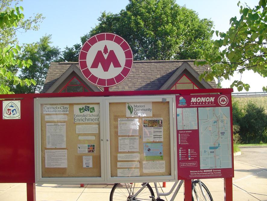
19 Pathways and Greenways Master Plan Final Report 4.3 BRANDING AND SIGNAGE FOR THE PATHWAY SYSTEM PROS Consulting is recommending that the Pathway System have a name, a brand logo, way-finding signage and rules of the pathways as well as a strong color scheme that let users know where they are on the pathway system (see examples). This would allow them to have greater awareness of where they are on the pathway system for them to run, walk or bicycle safely. Suggestion by staff includes calling the Pathway system Fit City Pathways with using the Fit City logo. 15
20 City of Valparaiso 16


21 Pathways and Greenways Master Plan Final Report 17

 for trailhead parking to access the trails,")
22 City of Valparaiso 4.4 DEVELOP PATHWAY AMENITIES FOR USERS OF THE SYSTEM PROS is recommending that the City develop key amenities along the Pathway system to include park benches, water fountains, restrooms, small levels (8 parking spots) for trailhead parking to access the trails, including adding safety phones, safety signs and exercise points along the pathways. 18
23 Pathways and Greenways Master Plan Final Report 4.5 PROGRAM THE USE OF PATHWAYS TO BUILD AWARENESS PROS is recommending that the Department create more events to promote the Pathway system when major spines are developed. Events such as competitive running events, charity walks, safe-routes to school walks, wellness and fitness events that promote Fit City and other type of events to get people out to experience the Pathways System. 4.6 DEVELOP IMPROVED MAINTENANCE PRACTICES The Department needs to incorporate improved maintenance practices along the Pathway system when completed to include daily removal of trash at trail heads, cleaning of the pathways in the fall, winter and spring from snow and debris as well as maintaining signage along the Pathway System. Not all the pathway will need to have snow removal but those connecting schools should have snow removal service. 4.7 DEVELOP PARTNERSHIPS WITH COMMUNITY The Department needs to develop partnerships with the School District, Utility Agencies, Developers, businesses along the pathway and other agencies to sponsor and develop their portion of the Pathway through a cooperative agreement with the City. Pathway sponsorship can include development of a portion of the pathway which cost approximately $230,000 or helping to maintain a mile of pathway which will cost approximately $12,000 a mile to maintain each year. 4.8 REGIONAL PATHWAYS DIRECTIVES WORKING WITH OTHER PLANNING AGENCIES Develop a regional approach to Pathways with regional trail plans that are being planned or are underway. This includes the Dunes Kankakee Trail. Develop joint grant opportunities for joint development of the regional system of trails being developed by NIRPC from Federal and SRTC monies. 4.9 CAPITAL IMPROVEMENT COSTS Currently the City is paying approximately $70 dollars a yard for concrete which equates to $168,000 a mile for an 8 pathway. When the City adds in the cost of design, engineering, Pathway amenities and signage the cost per mile will be approximately $275,000 a mile. This cost is similar to what other agencies and departments across Indiana are paying for 8 pathways. The goal is to get another 5 miles of Pathway Trail on the ground in the next five years which will focus on completing the majority of the Spine concept that is outlined in this Updated Pathways and Greenways Report. Total costs estimate will be $1,375,000 dollars FUNDING OPTIONS Seek dedicated funding from the following sources: Safe Routes to Schools Program 19

24 City of Valparaiso TEA-21 Money (Transportation Equity Act) from the Indiana Department of Transportation Developer Impact Fees Local Redevelopment and TIF money Locally as well as an Adopt-a- Trail Program with other entities such as the schools, University, local businesses, utility agencies and developers to develop local pathways Land and Water Conservation Fund Flood Control dollars from U.S. Corps of Engineers CDBG monies 20
25 Pathways and Greenways Master Plan Final Report CHAPTER FIVE - CONCLUSION The Updated Pathways and Greenways Master Plan was developed to gain additional public input on where Pathways and Greenways amenities are held in the order of importance to the citizens of Valparaiso. In addition, what pathways links should be made a priority for the city to develop over the next ten years to complete the pathway system and improve the community s access for safe walking, running and bicycling routes to schools, parks and other destinations in the City. The updated Pathways and Greenways plan describes and demonstrates the community s priority and maps out the routes that are priority to be developed. In 2011 and 2012, an additional 2.5 miles of pathways will be developed that follows the recommendations developed in this Updated Pathways and Greenways Plan. There is great cooperation between the Planning Department and the Parks and Recreation Department in the City in the development of these pathways as well as strong support from the Mayor and City Council. This cooperation and support to develop and fund these pathways is critical to build the spine system which will have strong economic appeal from people who live in the City and will support the Mayor s Fit City initiative. Future development of Pathways will require improved signage and way-finding efforts to help identify users when they are on the pathway and where the pathway is leading them. Continued efforts to find development money to build the pathways is also critical to the success of this project. The community has indicated that pathways are essential so as the City sets priorities for future development it is important that Pathways stay a priority. The 2005 Pathways Master Plan is a good document for the staff to continue to follow and use as a guide. The design guidelines and design principles outlined in the plan need to stay intact. Greater programming of the pathways will create more awareness and appreciation for the value of Pathways in the community. The Pathway system, when fully developed, will become a linear park for many people to enjoy for years to come. 21
City Council March 27, Parks, Recreation, and Trails Master Plan
 City Council March 27, 2018 Parks, Recreation, and Trails Master Plan Planning Process Develop Goals and Objectives Inventory of Areas and Facilities Needs Assessment And Identification Public Participation
Parks, and Recreation & Cultural Arts Master Plan Update
 Parks, and Recreation & Cultural Arts Master Plan Update Community Profile Public Input Summary: Staff Interviews conducted April 14 and 15, 2014 Citizens Workshop - conducted April 15 th and 24 th, May
PARTF Scoring System for Grants
 PARTF Scoring System for Grants The members of the N.C. Parks and Recreation Authority use the PARTF scoring system as one of several tools to select grant recipients. Please provide all of the information
Chapter 6. Overall Vision RECOMMENDATIONS. More Trail and Trail. Connections. Equal Access to Park. Facilities and Programs. Water Access.
 Overall Vision More Trail and Trail Connections Equal Access to Park Facilities and Programs Water Access Environment Variety Chapter 6 RECOMMENDATIONS Chapter 6 The following recommendations for park,
Provide and maintain sufficient public parks, recreation facilities, and open space to meet the recreational needs of County residents and visitors.
 (ROS) Goal Provide and maintain sufficient public parks, recreation facilities, and open space to meet the recreational needs of County residents and visitors. OBJECTIVE ROS.01 The County shall acquire,
STAFF RECOMMENDATION: Adopt the Parks and Recreation Master Plan 2013, or take other action as deemed appropriate.
 Regular 7. CITY COUNCIL AGENDA Meeting Date: 12/02/2013 TITLE: Parks and Recreation Master Plan 2013 Adoption Proposal - Dwight Curtis Responsible Staff: Dwight Curtis Backup Material: Backup material
Focus Groups. 8 Focus Group meetings including 2 with staff, 1 with seniors, and 1 with students
 Project Team Nan Lanahan, Parks & Recreation Jason Gallo, Parks & Recreation Rob Leslie, DEDP John Smolinsky, Planning Board Brent Meredith, Highway Joan Gavrilik, Friends of Parks & Rec MaryLyn Koval,
City of Valparaiso Pathways and Greenways Update
 City of Valparaiso Pathways and Greenways Update March 2017 ACKNOWLEDGMENTS MAYOR Jon Costas CITY ADMINISTRATOR Bill Oeding CITY COUNCIL John Bowker Robert Cotton Lenore Hoffman Matt Murphy Deb Porter
PARKS & RECREATION SUBCOMMITTEE. Oct. 1, 2015
 PARKS & RECREATION SUBCOMMITTEE Oct. 1, 2015 1999 Bond - $22,000,000 Land Acquisition Allen Station Phase II Neighborhood Parks PREVIOUS BOND ELECTIONS 1999 & 2007 2002 Bond - $4,000,000 Allen Senior Recreation
6. RECREATION AND OPEN SPACE ELEMENT
 6. RECREATION AND OPEN SPACE Introduction This Recreation and Open Space Element includes Goals, Objectives and Policies (GOP) that apply to the main campus in Gainesville and the Lake Wauburg Recreation
Noblesville Alternative Transportation Plan 2015
 Noblesville Alternative Transportation Plan 2015 Noblesville Alternative Transportation Plan 2015 This report document was prepared under Contract for the Noblesville Department of Parks and Recreation
PLANNING & DEVELOPMENT BOARD
 PLANNING & DEVELOPMENT BOARD AGENDA The regular meeting of the PLANNING & DEVELOPMENT BOARD will be held at 6:00 p.m. on DECEMBER 19TH, 2017 in COMMON COUNCIL CHAMBERS, City Hall, 108 E. Green Street,
Comprehensive Plan ADOPTED APRIL 2014
 Comprehensive Plan ADOPTED APRIL 2014 8 8. Outstanding Recreational & Cultural Opportunities We are proud of our community s parks and recreation system. Our community will ensure that the legacy of our
Comprehensive Park System Master Plan
 PARKS AND RECREATION Comprehensive Park System Master Plan Citizen Advisory Committee, June 5, 2012 - Meeting Notes Transcription MIG met with the Parks Citizen Advisory Committee on Tuesday, June 5th,
Support the implementation of Cape Coral's Comprehensive Plan. Protect and utilize the unique natural resources in the City.
 7.0 OVERVIEW - RECOMMENDATIONS Chapter 7 The preparation of the Cape Coral Parks and Recreation Master Plan spanned a period of approximately 12 months. Plan preparation included the input of a wide range
RECREATION AND OPEN SPACE ELEMENT
 RECREATION AND OPEN SPACE ELEMENT Last amended August 19, 2008 Table of Contents Objective Page 5.1 Park system defined... 5-1 5.2 Access to parks and recreational facilities... 5-2 5.3 Recreation and
Goals and Action Items
 Goals and Action Items Developing goals and action items is an important part of the recreation planning process. The overall goals of a recreation department are to provide recreation opportunities for
1. Parks & Recreation Neighborhood Parks Community Parks Special Use Sites 2. Open Space 3. Trails
 Appendix A: Park Classifications The intent of parks and recreation classifications is to aid in making acquisition and design decisions for park sites, facilities and the organization of recreation space
Master Plan Workshop October 25, 2007 Charlotte Mecklenburg Government Center
 Master Plan Workshop October 25, 2007 Charlotte Mecklenburg Government Center Land Discussion 1. What are the most important land related issues we need to address? Protect natural areas Passive walking
Town of Jamestown. Parks and Recreation Master Plan for Jamestown Park
 Town of Jamestown Parks and Recreation Master Plan for Jamestown Park Adopted December 16, 2014 Acknowledgements Town Council Keith Volz, Mayor Brock Thomas Lynn Montgomery Georgia Nixon-Roney William
ELK GROVE GENERAL PLAN VISION
 2-1 CHAPTER 2: 2-2 CREATING OUR The Community Vision for Elk Grove, expressed through a Vision Statement and a series of Supporting Principles, is a declaration of the kind of community that Elk Grove
City of Naples Parks Master Plan (Draft)
") City of Naples (Draft) CSAB April 12, 2016 OVERVIEW Presentation Outline Overview Needs Assessment Recap Response to Needs Implementation Strategy Questions, Discussion Preserving Naples: A vision plan
City of Naples (Draft) CSAB April 12, 2016 OVERVIEW Presentation Outline Overview Needs Assessment Recap Response to Needs Implementation Strategy Questions, Discussion Preserving Naples: A vision plan
WARM SPRINGS PARK MASTER PLAN
 TABLE OF CONTENTS page 1.0 Introduction and Overview 1 2.0 Information Gathering 2 3.0 Conceptual Alternative Development 8 4.0 Master Plan Development 14 5.0 Construction Cost Estimates 19 LIST OF FIGURES
Courthouse Planning Area
 Courthouse Planning Area Current Reality The Courthouse Planning Area is the characterized by expansive suburbanscale residential areas as well as the community resource planned area of athletic, educational,
RECREATION AND OPEN SPACE ELEMENT GOALS, OBJECTIVES, AND POLICIES
 RECREATION AND OPEN SPACE ELEMENT GOALS, OBJECTIVES, AND POLICIES Goal 7 To provide park facilities, recreation programs, and open space resources that are safe, adequate, and accessible to all City residents,
3.0 Community Consultation. BW Land
 3.0 Community Consultation A BW Land 3.0 Community Consultation See Appendix G The Results of the Public Consultation 3.1 Community Consultation The community consultation consisted of three open house
AVONDALE ESTATES GREENSPACE AD-HOC COMMITTEE
 AVONDALE ESTATES GREENSPACE AD-HOC COMMITTEE INVENTORY AND RECOMMENDATIONS REPORT November 7, 2018 Our Mission Statement: To provide assistance and support, through professional expertise in matters of
Office of Greenways & Trails Providing Statewide Leadership and Coordination. Southeast Greenways and Trails Summit October 1-3, 2017
 Office of Greenways & Trails Providing Statewide Leadership and Coordination Southeast Greenways and Trails Summit October 1-3, 2017 1 Office of Greenways and Trails The Office of Greenways and Trails
Little Neck Planning Area
 Little Neck Planning Area Current Reality The Little Neck Planning Area is characterized by established residential neighborhoods, Town Center and Pembroke. The Eastern and Western Branches of the Lynnhaven
M-NCPPC Park System in
 Park Planning & Stewardship Division Park & Trail Planning Section East County Science Center Master Plan Parks, Recreation, Trails, and Open Space- Issues and Opportunities PARK PLANNING & STEWARDSHIP
3. VISION AND GOALS. Vision Statement. Goals, Objectives and Policies
 Vision Statement Queen Creek s interconnected network of parks, trails, open spaces and recreation opportunities provide safe and diverse activities and programs that sustain its unique, small town, equestrian
Pungo/Blackwater Planning Area
 Pungo/Blackwater Planning Area Current Reality The Pungo/Blackwater Planning Area represents the rural landscape and lifestyle that encompasses nearly 40% of Virginia Beach. The Agricultural Reserve Program
Enhance the High Line Canal Projects
 Enhance the High Line Canal Projects Joint Project Proposal for Arapahoe County Open Spaces Funding Partner Sponsors: South Suburban Park and Recreation District City of Centennial City of Littleton October
A BLUEPRINT FOR BROCKTON A CITY-WIDE COMPREHENSIVE PLAN
 A BLUEPRINT FOR BROCKTON A CITY-WIDE COMPREHENSIVE PLAN Public Meeting October 2016 1 Plan Summary and Discussion Public Meeting May 4 2017 City of Brockton Bill Carpenter, Mayor Department of Planning
Southeast Quadrant Plan
 Southeast Quadrant Plan Southeast Quadrant Distinctive Features Land Use The Southeast Quadrant includes all the area within the planning area that is east of Interstate 5 and south of State Route 44.
Attachment M 9. PARKS AND RECREATION 9.1 PARKS, TRAILS AND OPEN SPACE PLAN
 Attachment M 9. PARKS AND RECREATION Goal: Create a comprehensive, maintained, and interconnected system of parks, pathways, and open spaces as well as a balanced program of recreational activities for
Arlington, Virginia is a worldclass
 EXECUTIVE S U M M A RY Arlington maintains a rich variety of stable neighborhoods, quality schools and enlightened land use policies, and received the Environmental Protection Agency s highest award for
Appendix A. Park Land Definitions
 Appendix A Park Land Definitions Mini Park May serve specific function for any and all ages, depending on need of the user area. Size range 1-5 acres with optimum size being 3 acres. Service area is sub-neighborhood
Great Neck Planning Area
 Great Neck Planning Area Current Reality The Great Neck Planning area is characterized primarily by large lot/lowdensity residential development with the majority of recreational opportunity existing as
SOUTHEAST SPORTS COMPLEX MASTER PLAN
 REPORT TO SOUTHGATE NEIGHBORHOOD COUNCIL APRIL 13, 2016 Visioning Process April 30: Stakeholder Meeting with Sports Groups May 5: Stakeholder Meeting with Southgate Land Use Committee May 13: SNC Meeting
This page intentionally blank.
 This page intentionally blank. Parks, Recreation, and Open Space Chapter Relationship to Vision Vision Parks, Recreation and Open Space Chapter Concepts County Government. County government that is accountable
RIDGES TO RIVERS OPEN SPACE NETWORI< OF THE MID-COLUMBIA DRAFT ACTION PLAN
 RIDGES TO RIVERS OPEN SPACE NETWORI< OF THE MID-COLUMBIA DRAFT ACTION PLAN Ridges to Rivers Open Space Network of the Mid-Columbia Region Draft Action Plan (8/6/08) The goals of the propose
Promoting Economic Development Through Upfront SEPA Review: Lessons from South Downtown Tacoma
 Promoting Economic Development Through Upfront SEPA Review: Lessons from South Downtown Tacoma 1 This session will focus on the City of Tacoma s South Downtown Subarea Plan and associated Non-Project SEPA
Report Date: June 25, 2013 Contact: Nick Kassam Contact No.: RTS No.: VanRIMS No.: Meeting Date: July 10, 2013
 ADMINISTRATIVE REPORT Report Date: June 25, 2013 Contact: Nick Kassam Contact No.: 604.829.2097 RTS No.: 10051 VanRIMS No.: 08-2000-20 Meeting Date: July 10, 2013 TO: FROM: SUBJECT: Standing Committee
Municipal Development Plan. Summer Village of ROCHON SANDS. Bylaw #241-18
 Municipal Development Plan Summer Village of ROCHON SANDS Bylaw #241-18 TABLE OF CONTENTS PART ONE: BACKGROUND AND PURPOSE 3 SECTION 1: BACKGROUND 3 SECTION 2: GOALS AND POLICIES 3 PART TWO: PHYSICAL ENVIRONMENT
Port Lavaca Future Land Use
 Port Lavaca Future Land Use Introduction The City of Port Lavaca is beginning to see sustained growth, after many years of relative stable population. New single family homes, apartments, and businesses
TAO S PARKS MASTER PLAN
 TAO S PARKS MASTER PLAN December 2017 Kit Carson Park Fred aca Park Eco Park Youth + Family Center Eco Park TAOS PARKS MASTER PLAN December 2017 SCOPE OF WORK Town of Taos Parks + Recreation Master Plan
8implementation. strategies
 PROGRAM STRATEGIES 8implementation strategies T he implementation actions of this chapter are designed to support and carry out the land use, economic development, transportation, urban design, and program
The following principles guide the development of goals and strategies to protect and promote these amenities:
 OPEN SPACE/PARKS/TRAILS/RECREATION GOALS/STRATEGIES Cherry Hills Village is a living environment that offers low density development, open areas, public scenic vistas, public trails and public parks. This
Northeast Quadrant Plan
 Northeast Quadrant Plan Northeast Quadrant Distinctive Features Land Use The Northeast Quadrant includes all the area within the planning area that is east of Interstate 5 and to the north of State Route
Yadkin River Greenway Feasibility Study Fact Sheet Village of Clemmons, Town of Lewisville, Town of Bermuda Run
 Fact Sheet Village of Clemmons, Town of Lewisville, Town of Bermuda Run Project Background The Yadkin River Greenway Feasibility Study is a joint project with the Village of Clemmons, the Town of Bermuda
Appendix E Section 4(f) Evaluation
 Evaluation") Appendix E Section 4(f) Evaluation Appendix E Draft Section 4(f) Evaluation E.1 Introduction This appendix addresses a federal regulation known as Section 4(f), which protects parks, recreation areas,
Appendix E Section 4(f) Evaluation Appendix E Draft Section 4(f) Evaluation E.1 Introduction This appendix addresses a federal regulation known as Section 4(f), which protects parks, recreation areas,
JCB & MIAMI SEWER SEPARATION PROJECT & ADAMS PARK WETLAND
 JCB & MIAMI SEWER SEPARATION PROJECT & ADAMS PARK WETLAND 30% Public Meeting November 29 th, 2012 ADAMS PARK MASTER PLAN H3 Studio Tonight s Agenda Review Adams Park Master Plan (H3 Studio) Context & Analysis
CITY OF GAINESVILLE PARKS, RECREATION AND CULTURAL AFFAIRS DEPARTMENT VISION 2020
 CITY OF GAINESVILLE PARKS, RECREATION AND CULTURAL AFFAIRS DEPARTMENT VISION 2020 A BLUE PRINT FOR THE NEXT 20 YEARS The PRCA Vision 2020 Master Plan, adopted in November 2012, addresses the current state
PUBLIC SPACES MASTER PLAN UPDATE (POPS) Joint Facilities Advisory Commission (JFAC) November 28, 2018
 Joint Facilities Advisory Commission (JFAC) November 28, 2018") PUBLIC SPACES MASTER PLAN UPDATE (POPS) Joint Facilities Advisory Commission (JFAC) November 28, 2018 1 AGENDA POPS Planning Context Timeline Public Input Final POPS Draft Next Steps 2 PLANNING CONTEXT
PUBLIC SPACES MASTER PLAN UPDATE (POPS) Joint Facilities Advisory Commission (JFAC) November 28, 2018 1 AGENDA POPS Planning Context Timeline Public Input Final POPS Draft Next Steps 2 PLANNING CONTEXT
PIERCE COUNTY IMPACT FEE WORKING GROUP. Pierce County s Park System
 PIERCE COUNTY IMPACT FEE WORKING GROUP Pierce County s Park System Project Title 2/25/2016 1 Pierce County s Park System Park System Concept Park Classifications Current Park Inventory Park System Comparison
CHAPTER 9: Parks, Recreation, and Open Space Element
 CHAPTER 9: Parks, Recreation, and Open Space Element INTRODUCTION: The Parks, Recreation, and Open Space Element is a comprehensive representation of the City s vision and goals for the future of the park,
Introduction. Chapter 1. Purpose of the Comprehensive Plan Plan Organization Planning Process & Community Input 1-1
 Chapter 1 Introduction Lakewood 2025: Moving Forward Together Purpose of the Comprehensive Plan Plan Organization Planning Process & Community Input 1-1 Purpose of the Comprehensive Plan The Comprehensive
CARMODY PARK MASTER PLAN
 the site Smith Reservoir Cottonwood Lake Kendrick Lake Carmody Rec Center Carmody Middle School Pool Court Play Carmody Pond Sanderson Ditch Sports Fields Foothills Ice Arena Open Field why a master plan?
10.0 Open Space and Public Realm
 10.0 Open Space and Public Realm 10.0 Open Space and Public Realm The Public Open Space System is comprised of: outdoor spaces available for public use that are either publicly owned (e.g., parks and
Community Visioning Workshop Prep
 Community Visioning Workshop Prep Visioning Workshop 73 Visioning Workshop: Public Events 1 2 3 4 74 Visioning Workshop: draft Schedule 75 Visioning Workshop: draft Schedule working to schedule stakeholder
COMPREHENSIVE PLAN & UNIFIED DEVELOPMENT ORDINANCE
 Village of Forsyth COMPREHENSIVE PLAN & UNIFIED DEVELOPMENT ORDINANCE Community Planning #6 Prepared by: Vision Statement We envision the Forsyth Community as one which will continue to maintain a small
Visioning Committee Kick-Off Meeting
 Visioning Committee Kick-Off Meeting June 11, 2018 The Team Project management, technical analysis, implementation, report preparation Public engagement, park review Recreation facilities review, operations
Alexandria Recreation & Education Program (AREP) April 2014
 April 2014") Alexandria Recreation & Education Program (AREP) April 2014 PROPOSITION (AREP RECREATION MILLAGE) VOTE: May 3, 2014! L14-095 - Rapides Parish, City of Alexandria - 6 mills tax, 20 years, 2014-2033, acquiring,
Alexandria Recreation & Education Program (AREP) April 2014 PROPOSITION (AREP RECREATION MILLAGE) VOTE: May 3, 2014! L14-095 - Rapides Parish, City of Alexandria - 6 mills tax, 20 years, 2014-2033, acquiring,
(ALL TIMES LISTED ARE APPROXIMATE AND SUBJECT TO CHANGE. )
") AGENDA TANGENT CITY COUNCIL AND PLANNING COMMISSION JOINT PUBLIC HEARING Wednesday March 16, 2011 PARK COMMISSION SESSION 7:00 p.m.. Bass Estate 32166 Old Oak Drive, Tangent, OR 97389 (ALL TIMES LISTED
AGENDA TANGENT CITY COUNCIL AND PLANNING COMMISSION JOINT PUBLIC HEARING Wednesday March 16, 2011 PARK COMMISSION SESSION 7:00 p.m.. Bass Estate 32166 Old Oak Drive, Tangent, OR 97389 (ALL TIMES LISTED
9. PARKS AND RECREATION
 9. PARKS AND RECREATION Goal: Create a comprehensive, maintained, and interconnected system of parks, pathways, and open spaces as well as a balanced program of recreational activities for residents of
PARKS. Chapter Introduction
 Chapter 4. PARKS 4.1. Introduction This Parks Element of the 2016 Comprehensive Plan Update provides direction and guidance, based on citizen input, in order to improve and maintain the City s existing
Potential Green Infrastructure Strategies May 6, 2015 Workshop
 Potential Green Infrastructure Strategies May 6, 2015 Workshop Background The City of Cortland is developing the Tioughnioga Urban Headwaters Green Infrastructure Action Plan with funding from the National
A 10-Year Strategic Plan for Recreation, Parks, Arenas and Culture City of Peterborough
 Vision 2025 A 10-Year Strategic Plan for Recreation, Parks, Arenas and Culture City of Peterborough Progress Update Prepared by: The RETHINK GROUP Leisure Services Planning & Management in association
Toronto Parks Renaissance Strategy
 Toronto Parks Renaissance Strategy Overview, Emerging Themes and Directions Presentation to EDPC, May 4, 2006 Parks Renaissance Strategy Presentation Agenda Project Overview Emerging Themes and Directions
APPENDIX D: PARKS AND RECREATION ACTION PLAN
 APPENDIX D: PARKS AND RECREATION ACTION PLAN Goals The following goals are specific to the development, maintenance, and operation of the existing parks in the Township, as well as the acquisition and
A larger version of this map is located on the last page of this PDF.
 MAP Committee Input McLoughlin Area Draft Vision Map A larger version of this map is located on the last page of this PDF. 1. The map above is intended to portray a vision for the McLoughlin area. It highlights
APPENDIX C: PUBLIC INPUT SUMMARY
 APPENDIX C: PUBLIC INPUT SUMMARY OVERVIEW The public process for the development of the GO! Green Oshtemo Plan was designed to follow both the legislative requirements for master plan adoption and the
City of Naples Parks Master Plan
 Parks Master Plan Draft Master Plan Presentation January 19, 2015 Presentation Outline Overview Needs Assessment Recap Response to Needs Implementation Strategy Questions, Discussion 2 OVERVIEW Project
PUBLIC SPACES MASTER PLAN UPDATE (POPS) Crystal City Citizen s Review Council October 24, 2018
 Crystal City Citizen s Review Council October 24, 2018") PUBLIC SPACES MASTER PLAN UPDATE (POPS) Crystal City Citizen s Review Council October 24, 2018 1 PLANNING CONTEXT Arlington County Comprehensive Plan UPDATE Related Documents: CIP Sector Plans Area Plans
PUBLIC SPACES MASTER PLAN UPDATE (POPS) Crystal City Citizen s Review Council October 24, 2018 1 PLANNING CONTEXT Arlington County Comprehensive Plan UPDATE Related Documents: CIP Sector Plans Area Plans
Chapter 11 PARKS, RECREATION AND OPEN SPACE
 Chapter 11 PARKS, RECREATION AND OPEN SPACE INTRODUCTION The 2016 Parks, Recreation and Open Space Plan (Park Plan) for Gig Harbor represents the City s vision and provides goals and objectives for the
The transportation system in a community is an
 7 TRANSPORTATION The transportation system in a community is an important factor contributing to the quality of life of the residents. Without a sound transportation system to bring both goods and patrons
PREVIOUS PUBLIC PARTICIPATION BRIEF October 2014
 Comprehensive Planning During the development of the county comprehensive plan, Cultivating Community: A Plan for Union County s Future from 2007 through 2009, and three concurrent multi municipal plans
PARK AND RECREATION MASTER PLAN UPDATE
 PARK AND RECREATION MASTER PLAN UPDATE 2014-2018 Prepared for: Avon Parks, Recreation and Beautification Council (PRBC) and Town of Avon Prepared by: Lehman & Lehman, Inc. 24-Apr-14 Mission Statement The
Appendix 4 Park, Trail, and Recreation Facilities For more information, call the Park Planning and Stewardship Division at
 Appendix 4 Park, Trail, and Recreation Facilities For more information, call the Park Planning and Stewardship Division at 301-650-4380 montgomery county planning board maryland-national capital park and
ALLEN CREEK GREENWAY. Citizens Advisory Committee Meeting #5 July 19, Allen Creek Greenway Master Plan. July 2017
 1 ALLEN CREEK GREENWAY MASTER PLAN Citizens Advisory Committee Meeting #5 July 19, 2017 Agenda 2 Final DRAFT Preferred Plan (30 min) Master Plan Document Outline (5 min) Potential Implementation Strategy
Executive Summary. Parks and Recreation Plan. Executive Summary
 Parks and Recreation Plan Executive Summary The Whitemarsh Township Parks and Recreation Plan sets forth a vision for how Whitemarsh Township can provide a premiere parks and recreation system reflective
A Vision For Miami s Twenty-first Century Parks And Public Spaces
 1 A Vision For Miami s Twenty-first Century Parks And Public Spaces Parks and Public Spaces in Miami 21 An urban renaissance is remaking the City of Miami as new residents, new visitors, and new investment
Florida Greenways and Trails System (FGTS) Plan Goals, Strategies and Objectives
 Plan Goals, Strategies and Objectives") Identification and Prioritization of the FGTS The Florida Greenways and Trails System (FGTS) is made up of existing, planned and conceptual trails and ecological greenways that form a connected, integrated
Identification and Prioritization of the FGTS The Florida Greenways and Trails System (FGTS) is made up of existing, planned and conceptual trails and ecological greenways that form a connected, integrated
Implementation Guide Comprehensive Plan City of Allen
 Implementation Guide 2030 Comprehensive Plan City of Allen DRAFT 2015 Implementation Guide Allen 2030 Comprehensive Plan INTRODUCTION The Comprehensive Plan serves as a guide for the growth and development
Chapter Purpose and Intent. 7.2 Applicability. 7.3 General Provisions RECREATIONAL OPEN SPACE
 Chapter 7. RECREATIONAL OPEN SPACE 7.1 Purpose and Intent The intent of this Chapter is to provide for centrally located, unencumbered land as neighborhood recreational open space and not to permit the
City of Mahtomedi Park System Plan Public Hearing Draft: September 13, 2006
 Chapter 6: IMPLEMENTATION INTRODUCTION Earlier chapters of this Plan analyzed existing conditions, identified park and recreation needs, and proposed park, trail, and open space recommendations. This chapter
Urban Planning and Land Use
 Urban Planning and Land Use 701 North 7 th Street, Room 423 Phone: (913) 573-5750 Kansas City, Kansas 66101 Fax: (913) 573-5796 Email: planninginfo@wycokck.org www.wycokck.org/planning To: From: City Planning
CITY OF SOCORRO, TEXAS REQUEST FOR QUALIFICATIONS FOR PROFESSIONAL LANDSCAPE DESIGN SERVICES FOR PROPOSED MAURO ROSAS PARK
 Trini Lopez Mayor Guillermo Madrid Jr. At Large Maria Reyes District 1 Gloria M. Rodriguez District 2 Mary B. Garcia District 3 / Mayor Pro Tem Jesus Gandara Jr. District 4 Willie Norfleet Jr. City Manager
Keyport. Vision for Keyport
 Keyport Vision for Keyport Keyport is a rural, historic waterfront village bounded and limited in size by its natural borders of water and the Naval Undersea Warfare Center. The community consists primarily
M E E T I N G S U M M A R Y
 M E E T I N G S U M M A R Y Architecture Preservation Interior Design Landscape Architecture Urban Planning & Design Graphic Design Project: RATIO Project No.: 17003.000 Date/Time: RIVERSIDE REGIONAL PARK
Public Input This appendix describes the public
 COMPREHENSIVE RECREATIONAL MASTER PLAN Public Input This appendix describes the public input process used during the planning of the Comprehensive Recreational Master Plan for the Parks and Open Spaces
NEW MODELS AND METRICS FOR PARKS SYSTEM PLANNING Wednesday, January 31st, 11:45 am - 1:00 pm. David Barth, PhD, AICP, CPRP, RLA
 NEW MODELS AND METRICS FOR PARKS SYSTEM PLANNING Wednesday, January 31st, 11:45 am - 1:00 pm David Barth, PhD, AICP, CPRP, RLA david@barthassoc.com https://www.planning.org/pas/memo/2016/may/ WHY DO
10 Implementation. Implementation. Responsibility for Implementation. Blueprint for Bloomsburg. Town of Bloomsburg Comprehensive Plan 10-1
 Implementation 10 Implementation This chapter overviews how to use the comprehensive plan as a land use and programming tool for the Town of Bloomsburg and recommends annual review of the plan by the Town
Animating the Rideau Canal December 2013
 Executive Summary Animating the Rideau Canal December 2013 Why study the Rideau Canal? The Rideau Canal has been an important part of Ottawa throughout its history, and has shaped and been shaped by the
Comprehensive Parks and Recreation Master Plan. Executive Summary. Submitted To: City of Milton, GA October 2012
 Comprehensive Parks and Recreation Master Plan Executive Summary Submitted To: City of Milton, GA October 2012 Executive Summary The City of Milton envisioned the need for an effective Master Planning
TOWN COUNCIL / PLANNING COMMISSION
 Workshop #3 TOWN COUNCIL / PLANNING COMMISSION January 20, 2011 Consultant Team In Attendance Tonight BMS Design Group Nevada City and San Francisco Michael Smiley, AICP, ASLA Partner-in-Charge Nancy L.
Mendota Heights 2040 Comprehensive Plan Draft Vers
 4 Parks and Trails The City of Mendota Heights boasts a variety of recreational and open space opportunities. Few cities can claim access to regional trails, riverside and lakeside parks, scenic bluffs
Objectives and Strategies for the Integration of Recreation, Parks and Open Space in Regional Plans
 BULLETIN 2 Objectives and Strategies for the Integration of Recreation, Parks and Open Space in Regional Plans TABLE OF CONTENTS Introduction 3 Land-use Framework Outcomes 1 4-8 Land-use Framework Outcomes
PARKS AND RECREATION ELEMENT
 PARKS AND RECREATION ELEMENT TABLE -3 First Priority 1 2 POTENTIAL SAN CARLOS TRAIL CONNECTIONS Crestview to Pulgas Ridge Open Space Preserve and San Francisco Watershed Lands Unimproved City-Owned Parcel