San Francisco Bay Area Upland Habitat Goals Project
|
|
|
- Doreen Lee
- 5 years ago
- Views:
Transcription


1 San Francisco Bay Area Habitat Preserving Biological Diversity for Future Generations A of the Bay Area Open Space Council funding provided by: California State Coastal Conservancy Gordon and Betty Moore Foundation California Resources Agency California Coastal and Marine Initiative of the Resources Legacy Fund Foundation Richard and Rhoda Goldman Fund David and Lucile Packard Foundation US Fish and Wildlife Service Coastal Program at San Francisco Bay Technical assistance provided by: National Park Service Rivers, Trails and Conservation Assistance Program


2 What am I going to talk about? Road Map San Francisco Bay Region What is Habitat? Why a Regional Plan? Methodology Access to Datasets/GIS Climate Change


3 San Francisco Bay Region Land Stats Acreage Statistics: California = Million Acres SF Bay Area = 4.5 Million Acres LANDSCAPE Protected = ~ 1.15 Million Acres!! Urban = ~ 775,000 Acres Not Protected = 2.5 Million Acres

4 What is the Habitat? Regional Biodiversity Conservation Plan How many acres of what types of habitats and in what configuration to preserve biodiversity in 9-county Bay Area? Identify a NETWORK of conservation lands. no list of prioritized properties voluntary implementation

5 Final Products Report with maps Framework to allow incorporation of new data and update goals Access to methods and tools for finer-scale planning GIS database available online Online interactive tool

6 What am I going to talk about? Road Map San Francisco Bay Region What is Habitat? Why a Regional Plan? Methodology Access to Datasets/GIS Climate Change


7 Why the Habitat? Development pressure threatening biodiversity 400,000 acres in next 30 years!! Successful implementation of the Baylands Ecosystem completed in 1999 Bay Area needs a science-based vision that recommends protection & management strategies to preserve biodiversity Lech Naumovich, CNPS
8 What am I going to talk about? Road Map Introduction San Francisco Bay Region What is Habitat? Why a Regional Plan? Methodology Access to Datasets/GIS Applying the
9 The Goal Setting Process Steering Committee Establishes guiding principles Drafts target species selection criteria Develops methodology for setting habitat goals Establishes 5 Focus Teams to set goals for species group Peer Review Coarse Filter Fine Filter Vegetation Mammals Birds Riparian/Fish Amphibians, Reptiles & Invertebrates Peer Review Final Report with habitat recommendations, management practices, implementation strategies, evaluation criteria
10 Coarse Filter Analysis - Vegetation Map Purpose: represent the diversity of vegetation cover 60 cover types, 51 natural/semi-natural 30 m grid Compromise between high resolution classification and even coverage across Bay Area Expert opinion from Vegetation Focus Team Update FMMP Ag and Urban
11 Coarse Filter Analysis - Landscape Units 29 Landscape Units (4 Urban Areas) Based on physiographic features valleys and mountains Capture diversity and biogeography of vegetation across study area Provide a means to break down recommendations into geographically coherent units.

12 Coarse Filter Analysis Conservation Targets 500+ Vegetation Types in 29 Landscape Units Conservation Targets Blue Oak Woodland
13 Coarse Filter - Rarity Rankings Rarity Ranking exercise with Vegetation Focus Team Rank 1 Globally Rare, Locally Highly Significant Rank 2 Locally Rare (<5% of LU) Rank 3 Common or matrix (>5% of LU) Rank 4 Urban, Intensive Ag, Non-native (golf courses, etc.) Conservation goals Rank 1=90% of remaining vegetation type Rank 2=75% Rank 3=50% 500+ Conservation Targets Rank 1, 2 & 3 vegetation types in all Landscape Units
14 Coarse Filter Process - Overview Conservation Targets Vegetation Types x Landscape Units Protection Rank 1,2,3 (90%,75%,50%)

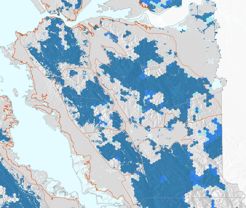
15 Coarse Filter Analysis Sonoma Area Closer Look at Sonoma Area. Here are our mapped ranks 1-3 We want 90% of Rank 1, 75% of Rank 2, and 50% of Rank 3 How to choose best configuration??
 3. Suitability of Landscape for Conservation fragmentation 4. Existing Protected Areas 5.")
16 Designing Conservation Lands Network Site Selection Model that meets set goals - MARXAN Achieves an efficient Conservation Lands Network based on inputs: 1. Conservation Targets Vegetation and Fine Filter 2. Conservation Rank 1,2,3 (90%,75%,50%) 3. Suitability of Landscape for Conservation fragmentation 4. Existing Protected Areas 5. Planning Units 100 Hectare Hexagons ~250 acres Starting Point for discussion
17 The Goal Setting Process Steering Committee Establishes guiding principles Drafts target species selection criteria Develops methodology for setting habitat goals Establishes 5 Focus Teams to set goals for species group Peer Review Coarse Filter Fine Filter Vegetation Mammals Birds Riparian/Fish Amphibians, Reptiles & Invertebrates Peer Review Final Report with habitat recommendations, management practices, implementation strategies, evaluation criteria
 with Fine Filter Targets: Additional")


18 Fine Filter Conservation Targets Enhance the Coarse Filter (Vegetation Communities) with Fine Filter Targets: Additional Plant Targets Old Growth Redwoods, T&E Species in CNDDB Mammals American Badger, Porcupine, T&E Species in CNDDB Birds Spotted Owl, Breeding Bird Areas, CNDDB Fish and Riparian Areas Steelhead and Coho Amphibian/Reptiles/Invertebrates Western Pond Turtle Other Vernal Pools


19 Fine Filter Conservation Targets Old Growth Redwood areas missing in biodiversity recommendations in Sonoma and San Mateo counties. Before After
20 Designing Conservation Lands Network Draft Results of Coarse Filter Analysis (some fine filter targets) Further adjust to incorporate fine filter targets Connectivity Analysis Future Climate Scenarios?
21 What am I going to talk about? Road Map San Francisco Bay Region What is Habitat? Why a Regional Plan? Methodology Access to Datasets/GIS Climate Change


22 GIS Data and Accessibility Incredible Resource for Bay Area Land Conservation Managers, Researchers and Planners. Free!! Not just GIS datasets Preassembled project Data organized into groups Preset symbology Cartographic set up Clean attributes Associated Handbook GIS Database Available Now!!


23 Applying the Key Datasets Vegetation Protected Lands Suitability Rarity UG Biodiversity Conservation Lands Network


24 What am I going to talk about? Road Map San Francisco Bay Region What is Habitat? Why a Regional Plan? Methodology Access to Datasets/GIS Climate Change

25 Climate Change Coarse Filter builds in a buffer against climate change - setting high goals for each rarity ranked veg type in each landscape unit Captures a broad range of mesoclimatic gradients that contributes to species richness Linkages between large protected areas will provide room to move as temps change January Minimum Temp We plan to evaluate the mesoclimatic coverage by overlaying the Marxan-derived Conservation Lands Network with PRISM grids of temperature and precipitation. July Max Temp Ackerly, 2009 Annual Precipitation
26 Mount Hamilton Southern Mayacamas Mt. Diablo Range Vaca West Blue Ridge Berryessa Sonoma Northern Mayacamas Sierra Azul Climate Mesoclimate X Landscape Unit Ppt mm July MaxT C Evaluate the spatial range of any climate variable within any landscape unit San Francisco Point Reyes Santa Cruz North Marin Coast Range Coastal Grasslands Middle East Bay Hills North East Bay Hills South East Bay Hills Sonoma Coast Range American Canyon Mt. Diablo Range Mount Hamilton American Canyon San Francisco North East Bay Hills South East Bay Hills Middle East Bay Hills Blue Ridge Berryessa Santa Cruz North Sierra Azul Point Reyes Vaca West Sonoma Coastal Grasslands Marin Coast Range Southern Mayacamas Northern Mayacamas Sonoma Coast Range


")

 Take Home Message - Local")

27 Climate Topoclimate + Mesoclimate 8-10 C inversion measured with Thermochrons Extrapolate across the landscape using topography Lay underneath PRISM Reality at scale of population processes (10-30 m) Evaluate variability within park parcel, any polygon, at scale at which populations are working (10-30m) Take Home Message - Local resiliency is quite high once spatial variability factored, can take a fairly big hit at macro climate level!
28 Climate Change Current Status Coarse Filter Analysis complete All Focus teams have met Finalizing data from Focus Teams, rerunning Marxan Slow down due to funding issues. Consider the as a source of data, collaboration and integration of your research to applied conservation planning. Planning to build an online interactive tool to assess biodiversity values of particular areas. Add climate change scenarios down the road? Looking forward to connecting with you all on additional research.


29 Habitat Team Nancy Schaefer, Manager Bay Area Open Space Council Consultant Melanie Denninger, Leader Coastal Conservancy Stuart Weiss, PhD, Science Advisor Bay Area Open Space Council Consultant Ryan Branciforte, Director of Conservation Planning Bay Area Open Space Council Thanks again to the Gordon and Betty Moore Foundation! Photos: Thanks to Jereme Monteau, Stu Weiss and Lech Naumovich Lech Naumovich, CNPS


30 Habitat GIS Database Available Now!! Contact Info: Nancy Schaefer, Manager - Bay Area Open Space Council Consultant nschaefer1@comcast.net Ryan Branciforte, Director of Conservation Planning - Bay Area Open Space Council ryan@openspacecouncil.org
31
32 The Goal Setting Process Steering Committee Establishes guiding principles Drafts target species selection criteria Develops methodology for setting habitat goals Establishes 5 Focus Teams to set goals for species group Peer Review Vegetation Mammals Birds Riparian/Fish Amphibians, Reptiles & Invertebrates Peer Review Final Report with habitat recommendations, management practices, implementation strategies, evaluation criteria
EACCS Goal: provide guidelines for mitigation practices and overall conservation in east Alameda County
 EAST ALAMEDA COUNTY CONSERVATION STRATEGY: A BLUEPRINT FOR ACTION Community Meeting June 11, 2009 Agenda Welcome and Introductions Project Update o Introduction o Progress to Date o Next Steps Perspectives
The Conservation Lands Network
 The Conservation Lands Network CLN 1.0 Progress Report Think Big. Connect More. www.bayarealands.org Table of Contents Foreword...i 1 The Conservation Lands Network...1 2 CLN 1.0 Progress Report...9 3
Executive Summary. Essential Connectivity Map (Figure ES-1)
") Executive Summary The California Department of Transportation (Caltrans) and California Department of Fish and Game (CDFG) commissioned the because a functional network of connected wildlands is essential
Executive Summary The California Department of Transportation (Caltrans) and California Department of Fish and Game (CDFG) commissioned the because a functional network of connected wildlands is essential
Landscape Conservation Design April, 2014
 Designing Sustainable Landscapes in the Northeast A project of the North Atlantic Landscape Conservation Cooperative & Northeast Climate Science Center Landscape Conservation Design April, 2014 Conceptual
Florida s Ephemeral Ponds and Pond-Breeding Amphibians
 Florida s Ephemeral Ponds and Pond-Breeding Amphibians What are Ephemeral Ponds? Ephemeral ponds are small, isolated wetlands that dry periodically. These ponds can be deep, sand-bottomed depressions with
STEWARDSHIP OF LONG ISLAND SOUND S ECOLOGICAL AND RECREATIONAL RESOURCES
 STEWARDSHIP OF LONG ISLAND SOUND S ECOLOGICAL AND RECREATIONAL RESOURCES Robin Kriesberg, Save the Sound, Inc. Thomas Halavik, US Fish and Wildlife Service Coastal Program An Initiative to Identify, Protect
The Landscape Project. New Jersey Department of Environmental Protection Division of Fish and Wildlife Endangered and Nongame Species Program
 The Landscape Project New Jersey Department of Environmental Protection Division of Fish and Wildlife Endangered and Nongame Species Program New Jersey is One of the smallest states in the country Yet
Antioch Habitat Conservation Plan/Natural Community Conservation Plan
 Antioch Habitat Conservation Plan/Natural Community Conservation Plan Science Advisor Workshop February 8, 2018 Kathryn Gaffney Project Manager Matt Ricketts Lead Biologist 1 PRESENTATION OUTLINE Background
Brockton. Produced in This report and associated map provide information about important sites for biodiversity conservation in your area.
 CONSERVING THE BIODIVERSITY OF MASSACHUSETTS IN A CHANGING WORLD Brockton Produced in 2012 This report and associated map provide information about important sites for biodiversity conservation in your
Goleta Community Plan Update
 Goleta Community Plan Update Ecology, Biology, and Habitats GVPAC Meeting Agenda [Wednesday, December 17, 2008, 6:00PM] Pledge of Allegiance and Roll Call Public Comment Period Administrative December
Great Lakes Conservation Blueprint for Terrestrial Biodiversity on the Canadian Shield
 Great Lakes Conservation Blueprint for Terrestrial Biodiversity on the Canadian Shield Bonnie L. Henson 1, Kara E. Brodribb 2 and John L. Riley 3 1 Ontario Ministry of Natural Resources 2,3 The Nature
APPENDIX C NATURAL RESOURCES MANAGEMENT PLAN: ACTIONS AND PRIORITIES
 APPENDIX C NATURAL RESOURCES MANAGEMENT PLAN: ACTIONS AND PRIORITIES TABLE C-1: Resource Actions and Priorities GOAL NRM-4 Objective 4.1: Restore Natural floodplain functions. Objective 4.2: Define and
Florida Forever Conservation Needs Assessment Overview Maps
 Florida Forever Conservation Needs Assessment Overview Maps Prepared by Florida Natural Areas Inventory, The maps in this document are derived from the Florida Forever Conservation Needs Assessment, an
50-year Water & Wetland Vision for England WORKSHOP DETAILS
 50-year Water & Wetland Vision for England Workshop 3: Wetland vision maps; your feedback on draft maps, methodology and ways forward 7 th December 2006 WORKSHOP DETAILS Theme 1: Methodology and prioritisation
Developing Landscape Conservation Designs & Adaptation Strategies for the GCPO LCC
 Developing Landscape Conservation Designs & Adaptation Strategies for the GCPO LCC D. Todd Jones-Farrand Science Coordinator david_jones-farrand@fws.gov 29-30 June 2015 Replace this box with key image
CHINO HILLS CHINO HILLS. September 6, 2012 OPEN SPACE MANAGEMENT PLAN
 September 6, 2012 Welcome! Today s Agenda Introduction Purpose and Scope of the Open Space Management Plan Where Have We Been? Presentation of Preliminary Findings Exercise: Issue identification and Priority
ADDENDUM TO BIOLOGICAL SCOPING SURVEY REPORT, BOTANICAL SURVEY AND WETLAND DELINEATION
 ADDENDUM TO BIOLOGICAL SCOPING SURVEY REPORT, BOTANICAL SURVEY AND WETLAND DELINEATION FOR AVALON INN (APN 069-241-27 & -04) 1201 & 1211 NORTH MAIN STREET FORT BRAGG, CA MENDOCINO COUNTY prepared for:
Green Infrastructure Planning for Sustainability and Resiliency
 Green Infrastructure Planning for Sustainability and Resiliency Linking Lands and Communities in the Land-of-Sky Region SAMAB Conference - November 18, 2010 www.linkinglands.org Linda Giltz, AICP, Regional
Countywide Green Infrastructure
 Montgomery County s Countywide Green Infrastructure F U N C T I O N A L M A S T E R P L A N The Maryland National Capital Park and Planning Commission INFRASTRUCTURE An underlying base or foundation especially
CHAPTER 1 Introduction
 CHAPTER 1 Introduction From sea to summit, Lane County covers almost 4,800 square miles of diverse Oregon landscape. Stretching from the Pacific Ocean through the Coastal Range, the Willamette Valley to
COLORADO S Comprehensive Wildlife Conservation Strategy Linking Conservation and Transportation Planning August 15, 2006
 COLORADO S Comprehensive Wildlife Conservation Strategy Linking Conservation and Transportation Planning August 15, 2006 The Input Process Input from DOW experts List of scientific experts Mailing to 1000
Conservation Plan. I. Property Information. II. Objectives. Natural Resource Objectives. Sustainability in Practice (SIP) Certified
 Certified") Conservation Plan Sustainability in Practice (SIP) Certified I. Property Information Vineyard Name and Establishment Date: Location: Map (attach showing blocks and acres): II. Objectives Natural Resource
Conservation Plan Sustainability in Practice (SIP) Certified I. Property Information Vineyard Name and Establishment Date: Location: Map (attach showing blocks and acres): II. Objectives Natural Resource
COASTAL CONSERVANCY. Staff Recommendation March 25, 2004 LOS ANGELES GREEN VISION PLAN. File No.: Project Manager: Marc Beyeler
 COASTAL CONSERVANCY Staff Recommendation March 25, 2004 File No.: 04-014 Project Manager: Marc Beyeler RECOMMENDED ACTION: Authorization to disburse up to $50,000 to the University of Southern California
ROLE OF LANDSCAPE CONSERVATION COOPERATIVES IN EVERGLADES RESTORATION
 ROLE OF LANDSCAPE CONSERVATION COOPERATIVES IN EVERGLADES RESTORATION GEER April 2017 Steve Traxler 1, Todd Hopkins 1, Beth Stys 2 1 US Fish and Wildlife Service 2 Florida Fish & Wildlife Conservation
2014 South Atlantic LCC
 2014 South Atlantic LCC Annual Report 1 Allie Stewart, U.S. FWS The South Atlantic LCC s 2014 Annual Report this year of progress and accomplishments is dedicated to South Atlantic LCC Coordinator, Ken
At the Heart of the Great Lakes
 Walpole Island Heritage Centre May 2010 At the Heart of the Great Lakes Bkejwanong: Where the Waters Divide Bkejwanong s Ecosystems OVERVIEW Walpole Island supports a rich mosaic of natural areas including
Case Study: City of San Mateo
 Published on GreenPlan-IT (http://greenplanit.sfei.org) Home > Archived Materials > GreenPlan-IT Toolkit Demonstration Report > Chapter 2. Case Study: City of San Mateo Case Study: City of San Mateo Chapter
Reconnect, Rewild & Restore
 Trophic Cascades, Habitat Fragmentation and Climate Change, the Need to Reconnect, Rewild and Restore Terrestrial Landscapes Keith Bowers, Biohabitats, Inc. CEER 2014 UN, IUCN, CBD, Ramsar, World Bank
Figure 1. Proposed Strategic Habitat Conservation Areas for Florida
 Figure 1. Proposed Strategic Habitat Conservation Areas for Florida Critical Lands and Waters Identification Project (CLIP) Cooperative Effort Century Commission for Sustainable Florida Florida Natural
A Landowner s Guide to Creating Woodland Pools for Amphibians and Other Wildlife
 Cornell Department of Natural Resources Conservation Education Program Fact Sheet Kristi L. Sullivan and Stephen J. Morreale A Landowner s Guide to Creating Woodland Pools for Amphibians and Other Wildlife
Riparian Ecology and Plant Identification Ventura River and Casitas Springs Community Center Nov 7-8, 2007
 The CNPS Plant Science Training Program is proud to present a two-day Riparian workshop, at the, Casitas Springs (between Ventura and Ojai) Target audience: Professional and student botanists, biologists,
Albion Hills Conservation Area Master Plan. Public Information Session
 Albion Hills Conservation Area Master Plan Public Information Session 1 03.25.2014 Meeting Agenda 1. Project Introduction Property History Current Use Master Plan Process 2. Draft Vision Goals and Objectives
Natural Resources Research Summaries for National Park Service Units within the Southeast Coast Network
 National Park Service U.S. Department of the Interior Southeast Coast Network Atlanta, Georgia Natural Resources Research Summaries for National Park Service Units within the Southeast Coast Network Request
Virginia DCR- Natural Heritage Program. Tools for Linking Conservation and Transportation Planning
 Virginia DCR- Natural Heritage Program Tools for Linking Conservation and Transportation Planning November 9, 2009 MISSION: to conserve Virginia's biodiversity through statewide biological inventory, protection,
Green Infrastructure. by Karen Engel, NYS DEC. NYS Department of Environmental Conservation
 Green Infrastructure by Karen Engel, NYS DEC What is Green Infrastructure? For some it s all about water Green Infrastructure techniques use soils and vegetation to infiltrate, evapotranspirate, and/or
Sonoma Valley Wildlife Corridor Project: Management and Monitoring Strategy
 Sonoma Valley Wildlife Corridor Project: Management and Monitoring Strategy Funding provided by the Gordon and Betty Moore Foundation, a grant made through the Bay Area Conservation Initiative of Resources
A Delta Renewed: A Guide to Science Based Ecological Restoration in the Delta
 A Delta Renewed: A Guide to Science Based Ecological Restoration in the Delta J. Letitia Grenier, San Francisco Estuary Institute, letitia@sfei.org Julie Beagle, San Francisco Estuary Institute, julieb@sfei.org
Landscaping and Biodiversity: Conserving Biodiversity in Urban Planning and Development
 Landscaping and Biodiversity: Conserving Biodiversity in Urban Planning and Development Audio Options TO USE YOUR COMPUTER'S AUDIO: When the Webinar begins, you will be connected to audio using your computer's
New Jersey Habitat Connectivity Project
 Mapping Core Team Meeting Two January 25 th, 10 am - noon Assunpink Wildlife Management Area, Main Office Meeting attendees: Patrick Carr, Margaret Conroy, Karl Figueiredo, Gretchen Fowles, Gylla MacGregor,
Community Conservation Workshop. Lake Placid
 Community Conservation Workshop Lake Placid 2 Community Conservation Program Welcome! We have designed a Community Conservation Program that listens to the needs of community members. We are conducting
4. What are the goals of the Kawarthas, Naturally Connected project? 7. What are watersheds and why are they being used as the project boundaries?
 Frequently Asked Questions (FAQs) 1. What are Natural Heritage Systems (NHS)? 2. Why are they important? 3. Which areas of the province have undertaken NHS projects? 4. What are the goals of the Kawarthas,
OPEN SPACE CHAPTER 7: OVERVIEW. Preserve open space to protect natural resources, enhance character and provide passive recreation opportunities
 CHAPTER 7: OPEN SPACE OVERVIEW Ridgefield has made tremendous progress permanently preserving areas of town as open space. Open space preservation can serve many important purposes, including: protect
Candlestick Point SRA Yosemite Slough Restoration Project. Presented by
 Candlestick Point SRA Yosemite Slough Restoration Project Presented by Yosemite Slough Restoration Project The Center of a Revitalized Waterfront in Southeastern San Francisco The Yosemite Slough Restoration
Aquatic, Terrestrial and Landscape Conservation Design Tools and Products of the North Atlantic LCC
 Aquatic, Terrestrial and Landscape Conservation Design Tools and Products of the North Atlantic LCC Scott Schwenk Science Coordinator, North Atlantic LCC Chesapeake Bay FWS Partners Meeting Annapolis,
Chapter 5: Natural Resources and Environment
 NATURAL RESOURCES AND ENVIRONMENT 5-1 5 Chapter 5: Natural Resources and Environment BACKGROUND AND INTENT Urban expansion represents the greatest risk for the future degradation of existing natural areas,
Large Landscape Restoration and the National Park System
 National Park Service U.S. Department of the Interior Large Landscape Restoration and the National Park System April 21, 2016 National Conference on Ecosystem Restoration Raymond M. Sauvajot, Ph.D. Associate
Key Elements of Successful Conservation Planning. John Paskus October 17, 2013 Pierce Cedar Creek Institute Michigan Natural Features Inventory
 Key Elements of Successful Conservation Planning John Paskus October 17, 2013 Pierce Cedar Creek Institute Michigan Natural Features Inventory What is Conservation Planning? Pressey et al (2008): The process
GIS to Estimate Archaeological Site Loss and Develop Conservation Strategies
 GIS to Estimate Archaeological Site Loss and Develop Conservation Strategies Terry Jackson Office of Decision Support Systems Planning and Environmental Management Division Georgia Department of Community
National Association of Conservation Districts. Kris Hoellen Vice President, Sustainable Programs The Conservation Fund September 19, 2013
 National Association of Conservation Districts Kris Hoellen Vice President, Sustainable Programs The Conservation Fund September 19, 2013 Our Mission The Conservation Fund forges partnerships to conserve
World Heritage Cultural Landscapes
 International Expert Workshop on Integrity & Authenticity of World Heritage Cultural Landscapes Dec 11, 2007 - Dec 12, 2007 Aranjuez, Spain Patricia M. O Donnell, FASLA, AICP, IFLA, ICOMOS Heritage Landscapes,
Dedham. Produced in This report and associated map provide information about important sites for biodiversity conservation in your area.
 CONSERVING THE BIODIVERSITY OF MASSACHUSETTS IN A CHANGING WORLD Dedham Produced in 2012 This report and associated map provide information about important sites for biodiversity conservation in your area.
Planning for Staten. Habitat Restoration and Green Infrastructure. Island s North Shore
 Habitat Restoration and Green Infrastructure Planning for Staten Island s North Shore Walker Park December 7, 2017 NYC Parks Forestry, Horticulture, and Natural Resources Funded by the NYS Department of
SF RECREATION & PARK DEPARTMENT URBAN TRAILS PROGRAM
 SF RECREATION & PARK DEPARTMENT URBAN TRAILS PROGRAM TRAIL IMPROVEMENTS October 5, 2011 TRAIL IMPROVEMENTS 6:30 8:00 p.m. AGENDA WELCOME & INTRODUCTION URBAN TRAILS PROGRAM OVERVIEW TRAIL IMPROVEMENTS
Planning for Staten. Habitat Restoration and Green Infrastructure. Island s North Shore
 Habitat Restoration and Green Infrastructure Planning for Staten Island s North Shore Community Board 1 March 1, 2018 NYC Parks Forestry, Horticulture, and Natural Resources Funded by the NYS Department
Town of Sahuarita Open Space Plan Element. University of Arizona Planning Program Projects Team
 Town of Sahuarita Open Space Plan Element University of Arizona Planning Program Projects Team Introduction Planning students in the Planning Program Project Class Overall Goal Potential uses of $1.5 Million
GREEN NETWORK APPLICATIONS IN ESTONIA
 GREEN NETWORK APPLICATIONS IN ESTONIA Kalev Sepp, Tuuli Veersalu, Martk Külvik Estonian University of Life Sciences 1 WHY? BACKGROUND - POLITICAL By adopting the Pan-European Biological and Landscape Diversity
III. PROJECT DESCRIPTION
 III. PROJECT DESCRIPTION A. PROJECT LOCATION Regional Setting The project site is located in the southeast quadrant of the City of Chico in Butte County, California and is comprised of four parcels totaling
Photo by Carlton Ward Jr. Executive Summary
 Photo by Carlton Ward Jr. Executive Summary The Cooperative Conservation Blueprint (Blueprint) is a multi-partner strategic conservation process developed by the Florida Fish and Wildlife Commission (FWC)
Chapter 3: Natural Environment. Proposed Waikato District Plan Stage 1. (Notified version)
") Chapter 3: Natural Environment Proposed Waikato District Plan Stage 1 Page 2 of 7 Contents Chapter 3: Natural Environment... 3 3.1 Indigenous Vegetation and Habitats... 3 3.1.1 Objective Biodiversity and
Chapter 3: Natural Environment Proposed Waikato District Plan Stage 1 Page 2 of 7 Contents Chapter 3: Natural Environment... 3 3.1 Indigenous Vegetation and Habitats... 3 3.1.1 Objective Biodiversity and
Improving Communities Through the Arroyo Seco Sustainability Campaign and Watershed Assessment
 Improving Communities Through the Arroyo Seco Sustainability Campaign and Watershed Assessment Arroyo Seco Headwaters in the San Gabriel Mountains Major tributary to the Los Angeles River 44 square mile
Oakland County s Green Infrastructure Vision. L. Brooks Patterson Oakland County Executive
 Oakland County s Green Infrastructure Vision L. Brooks Patterson Oakland County Executive Southeast Michigan 20 miles northwest of Detroit Consists of 910 square miles Population of 1.2 million More than
[FWS R8 R 2015 N087; FXRS282108E8PD0 156 F ] South Bay Salt Pond Restoration Project, Phase 2; Don Edwards National Wildlife
![[FWS R8 R 2015 N087; FXRS282108E8PD0 156 F ] South Bay Salt Pond Restoration Project, Phase 2; Don Edwards National Wildlife](/thumbs/84/90602803.jpg "[FWS R8 R 2015 N087; FXRS282108E8PD0 156 F ] South Bay Salt Pond Restoration Project, Phase 2; Don Edwards National Wildlife") Surname Billing Code: 4310 55 Deputy RD ARD Refuges DEPARTMENT OF THE INTERIOR Fish and Wildlife Service Solicitor Refuge Supervisor Asst. Refuge Supervisor Ch. Natural Resources Project Leader [FWS R8
Surname Billing Code: 4310 55 Deputy RD ARD Refuges DEPARTMENT OF THE INTERIOR Fish and Wildlife Service Solicitor Refuge Supervisor Asst. Refuge Supervisor Ch. Natural Resources Project Leader [FWS R8
Landscape Conservation Design June, 2014
 Designing Sustainable Landscapes in the Northeast A project of the North Atlantic Landscape Conservation Cooperative & Northeast Climate Science Center June, 2014 Adaptive Establish Conservation Goals
Integration of Planning & Environmental Analysis in Transportation
 Integration of Planning & Environmental Analysis in Transportation How Natural Resources Conservation Fits into SAFETEA-LU Planning Rules Transportation Research Board Annual Meeting January 2008 Jeff
Conservation Corridor Planning and Green Infrastructure Themes
 Conservation Corridor Planning and Green Infrastructure Themes Prepared by the Green Infrastructure Center Inc. and the Northern Virginia Regional Commission February 22, 2011 Brief Overview Project Background
Presentation to Planning Committee, DMM
 District Municipality of Muskoka Muskoka Official Plan Review Background Study: Natural Heritage Review of Urban Centres and Species At Risk Dale Leadbeater 1 September 2011 Presentation to Planning Committee,
Concord Hills Regional Park Land Use Plan
 Photo by Stephen Joseph Public Meeting #2: Design Concepts Review November 19, 2015 Agenda Photo by Stephen Joseph 1) Welcome 2) Presentation Project Background and Status Existing Conditions, Opportunities,
CALGARY: City of Animals Edited by Jim Ellis
 CALGARY: City of Animals Edited by Jim Ellis ISBN 978-1-55238-968-3 THIS BOOK IS AN OPEN ACCESS E-BOOK. It is an electronic version of a book that can be purchased in physical form through any bookseller
Lower Columbia River and Coastal Landscape Conservation Design
 Today s Presenters: Lower Columbia River and Coastal Landscape Conservation Design John Mankowski, North Pacific Landscape Conservation Cooperative Sara Evans-Peters, Pacific Birds Tom Miewald, US Fish
Why the workshop, why the cases?
 Green Infrastructure in Central and Eastern Europe Cases from the Czech Republic, Poland and Romania Kristijan Civic, ECNC and Agnes Zolyomi, Zolyomi, CEEweb Workshop on redesigning the landscape, connecting
California Landscape Conservation Cooperative
 californialcc.org California Landscape Conservation Cooperative Debra Schlafmann, Coordinator October 19, 2016 Landscape Conservation Cooperatives There are 22 LCCs http://lccnetwork.org/ LCC Map Landscape
CAMPUS HISTORY AND STEWARDSHIP
 CHAPTER TWO CAMPUS HISTORY AND STEWARDSHIP The stewardship of the UC Davis campus history and the rich collection of natural and cultural resources is a fundamental task for the LRDP. This chapter is organized
Pequotsepos Brook Preserve
 AVALONIA LAND CONSERVANCY, Inc. P.O. Box 49, Old Mystic, CT 06372 Pequotsepos Brook Preserve Property Management Plan Maritime Drive Mystic, New London County, Connecticut Stonington Town Committee is
Wildlife Ecology Internship at Point Reyes National Seashore
 Wildlife Ecology Internship at Point Reyes National Seashore guidance of the Wildlife Program of the Integrated Resources Division at Point Reyes National Seashore and assist in documenting and assessing
I ll be talking about the Designing Sustainable Landscapes project today. This is a large integrated modeling effort our group at UMass has been
 1 I ll be talking about the Designing Sustainable Landscapes project today. This is a large integrated modeling effort our group at UMass has been working on for the past 5 years, in close collaboration
3. VISION AND GOALS. Vision Statement. Goals, Objectives and Policies
 Vision Statement Queen Creek s interconnected network of parks, trails, open spaces and recreation opportunities provide safe and diverse activities and programs that sustain its unique, small town, equestrian
Enhancing Biodiversity in an Increasingly Urban World
 Enhancing Biodiversity in an Increasingly Urban World Robin Grossinger, San Francisco Estuary Institute, robin@sfei.org Throughout the 20th century a wave of urbanization has swept across the planet, driving
Prioritizing Tidal Wetlands: A Landscape Approach
 Prioritizing Tidal Wetlands: A Landscape Approach Laura Brophy Director, Estuary Technical Group Institute for Applied Ecology Corvallis, OR College of Earth, Ocean and Atmospheric Sciences, Oregon State
Smart Growth for Dallas
 Smart Growth for Dallas Data-driven decisions for the future of Dallas parks, open spaces, and green infrastructure Dallas Park and Recreation Board March 10, 2016 Agenda I. Welcome and Introductions II.
Community Conservation Workshop. Saranac River Basin Communities
 Community Conservation Workshop Saranac River Basin Communities 2 Community Conservation Program Welcome! We have designed a Community Conservation Program that listens to the needs of community members.
Indigenous biodiversity, restoration and the perfect New Zealand City. Bruce Clarkson, Cilla Wehi & Lars Brabyn
 Indigenous biodiversity, restoration and the perfect New Zealand City Bruce Clarkson, Cilla Wehi & Lars Brabyn Important note to users This power point is as presented at the New Zealand Ecological Society
Scottish Natural Heritage Sharing Good Practice Programme
 Scottish Natural Heritage Sharing Good Practice Programme January December 2018 Sharing Good Practice is a unique programme of events for people from a wide variety of sectors, including land managers,
1.0 Background. 1.1 Study Process
 1.0 Background Planning for Terwillegar Park began in 2005 with the preparation of A Vision for Terwillegar Park (Randall Conrad & Associates), a City wide public consultation and visioning exercise. The
Santa Barbara Restoration Project Database. Cheadle Center for Biodiversity and Ecological Restoration University of California, Santa Barbara
 University of California, Santa Barbara 1 CONTENTS Introduction... 2 Setting... 2 Methods... 3 Results... 5 Discussion... 10 Conclusions... 12 2 INTRODUCTION The Santa Barbara Restoration Project Database
ABNJ Deep Seas Project:
 ABNJ Deep Seas Project: Sustainable Fisheries Management and Biodiversity Conservation of Deep-sea Living Marine Resources and Ecosystems in ABNJ Area-based planning in ABNJ Hannah Thomas Project Manager,
Preface. Erie. Scranton. Allentown. Pittsburgh. Harrisburg. Philadelphia
 The Southern Alleghenies Region The Southern Alleghenies Region spans the Laurel Highlands and Allegheny Front in the west across the Appalachians to the east. It is comprised of Blair, Bedford, Cambria,
April 11, 2016 Park Board Chair and Commissioners General Manager Vancouver Board of Parks and Recreation New Brighton Salt Marsh - Preferred Concept
 TO: FROM: SUBJECT: April 11, 2016 Park Board Chair and Commissioners General Manager Vancouver Board of Parks and Recreation New Brighton Salt Marsh - Preferred Concept RECOMMENDATION A. THAT the Vancouver
Wildlife and Countryside Link s Landscape Scale Conservation position statement
 Wildlife and Countryside Link s Landscape Scale Conservation position statement February 2010 Wildlife and Countryside Link (Link) brings together over 30 voluntary organisations concerned with the conservation
Baylands Segment J. Bay between the Golden Gate and Segment J. Coyote Point. of For managed ponds. included habitat enhancement.
 Baylands Segment J Crissy Field Alameda Naval Air Station Heron's Head Park COLMA CREEK SFO Millbrae San Mateo BAYLANDS 2009 SAN FRANCISCO AREA san francisco area Western side of central San Francisco
Blue/Green Infrastructure Study Accomack County, VA
 Blue/Green Infrastructure Study Accomack County, VA Draft Asset Maps March 8-9, 2010 Green Infrastructure Center, Inc. 2 Overview What is Green and Blue Infrastructure Project Timeline & Tasks Literature
Redesigning Vogel Flat Angeles National Forest, California
 Redesigning Vogel Flat Angeles National Forest, California WRPI Watershed Management Internship 2017 Cristina Plemel, Master s of Landscape Architecture California State Polytechnic University, Pomona
Overview of Southwestern Pennsylvania Commission s (SPC) 2040 Long Range Transportation Plan (LRTP)
 2040 Long Range Transportation Plan (LRTP)") Overview of Southwestern Pennsylvania Commission s (SPC) 2040 Long Range Transportation Plan (LRTP) Presented to Pennsylvania Agency Coordination Meeting May 27, 2015 Doug Smith & Ryan Gordon 1 Southwestern
Overview of Southwestern Pennsylvania Commission s (SPC) 2040 Long Range Transportation Plan (LRTP) Presented to Pennsylvania Agency Coordination Meeting May 27, 2015 Doug Smith & Ryan Gordon 1 Southwestern
RECREATION, OPEN SPACE AND GREENWAYS ELEMENT GOALS, OBJECTIVES, AND POLICIES
 RECREATION, OPEN SPACE AND GREENWAYS ELEMENT GOALS, OBJECTIVES, AND POLICIES GOAL R-1: DEVELOP A RECREATION, OPEN SPACE AND GREENWAYS SYSTEM AS AN INTEGRAL COMPONENT OF AN OVERALL, COUNTY-WIDE ECONOMIC
TENDER. Subject of the tender: Field-work on verification of ecological corridors
 TENDER CEEweb for Biodiversity (1021 Budapest, Széher út 40., Hungary, registration no. 1634) makes this Tender for consulting services to be completed by 1/September/2018, to be started in September 2017.
Conserving Illinois North Shore Ravines
 Conserving Illinois North Shore Ravines Rebecca Grill, Natural Areas Manager, Park District of Highland Park, rgrill@pdhp.org Jeff Boeckler, Principal Water Resource Specialist, Northwater Consulting,
City of Missoula and Missoula County Open Space Planning Open House
 City of Missoula and Missoula County Open Space Planning Open House FEBRUARY 6, 2018 The following slides contain the display board content from the open house. Please use boards to answer questions in
LIVING INFRASTRUCTURE PLAN
 LIVING INFRASTRUCTURE PLAN AUSTRALASIAN NETWORK FOR ECOLOGY AND TRANSPORTATION 30 APRIL 2018 Maggie Baron, Melbourne Metro Rail Authority Sheridan Blunt, Loci Environment & Place Inc. RAIL AND SUSTAINABILITY
Public Visioning City of Kelso Planning Commission
 Shoreline Master Program Update Public Visioning City of Kelso Planning Commission November 13, 2012 Schedule Jurisdiction Inventory Analysis Visioning Topics Process Governing Principles Structure of
Template for Restoration in a Lake Superior Area of Concern. Template for Restoration in a Lake Superior Area of Concern
 Keith Bowers, Principal Ivette Bolender, Great Lake Bioregion Team Leader Presentation outline: Project background Master planning process Habitat restoration approach Lessons learned Hog Island and Newton
HUDSON VALLEY REGIONAL COUNCIL 3 Washington Center, Newburgh NY
 PROJECT AREA: HYDE PARK HUDSON VALLEY REGIONAL COUNCIL 3 Washington Center, Newburgh NY 12550 http://www.hudsonvalleyregionalcouncil Insert aerial site photo with streets labeled GREEN INFRASTRUCTURE CONCEPT