Planning Charlotte s Future. Planning Committee June 21, 2016
|
|
|
- Derrick Roberts
- 5 years ago
- Views:
Transcription

1 Planning Charlotte s Future Planning Committee June 21, 2016

2 Charlotte s Vision Livable city Vibrant economy Thriving natural environment Diverse population Choices for housing, education, employment Safe & attractive neighborhoods Citizen involvement Charlotte will continue to be one of the most livable cities in the country, with a vibrant economy, a thriving natural environment, a diverse population and a cosmopolitan outlook. Charlotteans will enjoy a range of choices for housing, transportation, education, entertainment and employment. Safe and attractive neighborhoods will continue to be central to the City s identity and citizen involvement key to its vitality. 2

3 Implementing Our Vision: Centers, Corridors & Wedges Activity Centers are generally appropriate for new growth, with generally increased intensity of development. Growth Corridors are priority locations for new growth, but may include specific neighborhoods for preservation. Wedges are predominantly low density residential with limited higher density housing and neighborhood serving commercial uses. 3
 Place-types will function as the foundation for zoning districts Place types")

4 Place Types: Building on an existing foundation Place-Based Ordinance Foundation Community Character Manual (CCM) Place-types will function as the foundation for zoning districts Place types reinforce existing quality & character and/or facilitate change where desired Place types established by the CCM will provide clear link to Zoning Map Each place type may result in multiple zoning districts 5
5 Development Ordinance & Policy Update Policies & Plans Centers, Corridors & Wedges Growth Framework General Development Policies Guidance on Community Design NEW Community Character Manual Place Types Area Plans Parcel specific Future Land Use Establish consistent terminology (place types) to define the places we are trying to create: Vision Land Use Form & pattern (setback, height, density, streetscape, etc.) 6
6 Place Types: Expanding Our Vocabulary Northlake Mall Place Type: Vision Land Use Form & Pattern Setback Height Density Parking Streetscape Open Space Morehead Street Future Land Use: Residential/Office/Retail 7


7 Place Types: Expanding Our Vocabulary Northlake Mall Mixed Use Activity Center Place Type: Vision Land Use Form & Pattern Setback Height Density Parking Streetscape Open Space Morehead Street Mixed Use Neighborhood 8
 Tree (Chapter 21) Streets & Sidewalks (Chapter 19) Post-Construction Stormwater")
8 Development Ordinance & Policy Update Policies & Plans Centers, Corridors & Wedges Growth Framework General Development Policies Guidance on Community Design NEW Community Character Manual Place Types Area Plans Parcel specific Future Land Use Regulations & Ordinances Zoning Ordinance Subdivision (Chapter 20) Tree (Chapter 21) Streets & Sidewalks (Chapter 19) Post-Construction Stormwater (Chapter 18) Unified Development Ordinance 9


9 Insert pics of place type posters 11

10 Place Types From Working Farms to Metropolitan Centers
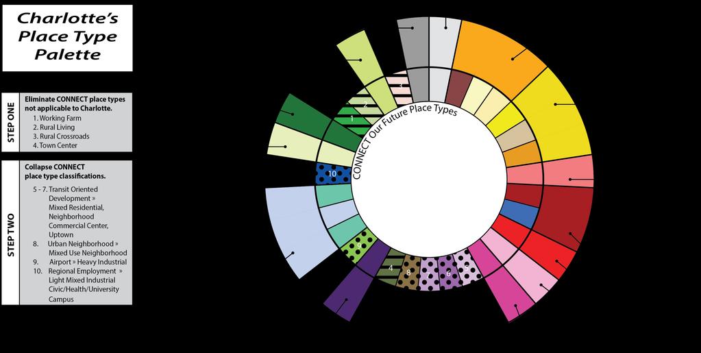
11 Palette Refinement 13
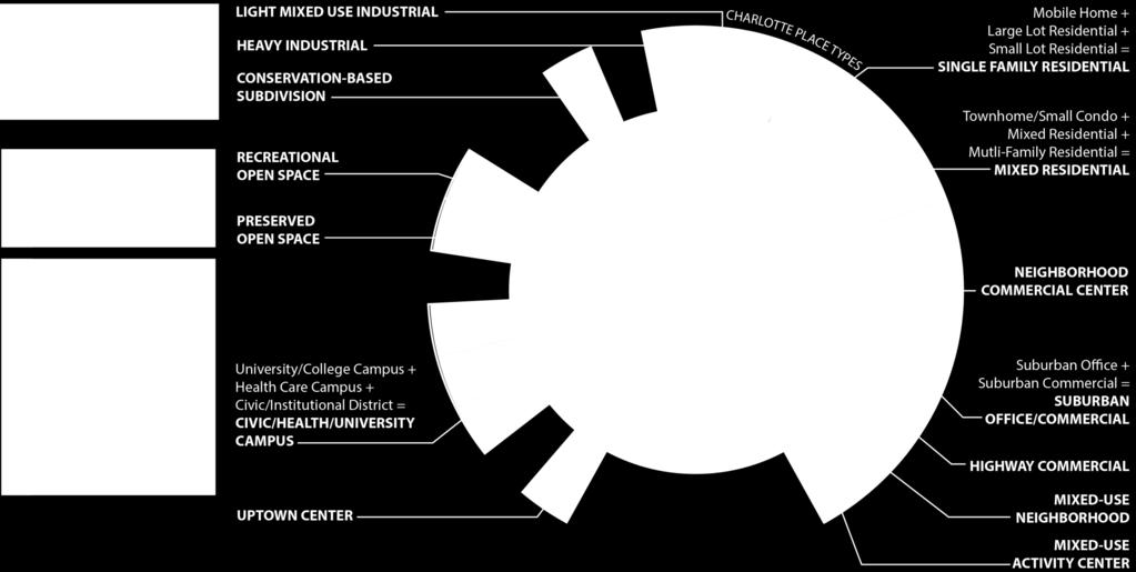
12 Place Types: Palette 14
13 15

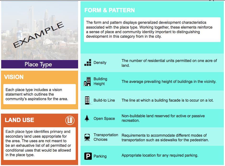
14 Vision Primary Land Uses Secondary Land Uses Form & Pattern + Orientation + Maximum Building Length + Tree Canopy/ Preservation
15 Place Type Form and Pattern Place Type Land Uses Non- Typical Lot Residential Residential Coverage Density Intensity (FAR) Building Types Prevailing Building Height Tree Orientation Transporta- Typical Maximum tion Choices Block Setback or Length Build to Line Building Canopy/ Open Length Preservatio Space Street Form + Pattern Elements n Pattern Size Average Non- Residential Building Street Connectivity Parking Provisions Typical Street Cross Sections Transitions Zoning Districts Conservation-Based Subdivision Single Family Residential (PLU) Single Family Residential (SLU) Religious Institutions, Schools, Parks, Recreational Facilities, Daycares Up to 8 DUA SF Detached, SF Attached, Accessory Dwelling Unit, Duplex 1-3 stories Activate Street fronting façade (aka no blank walls) walk, bike, 600' max car, transit (subdivision ord) Setback NA Tree save active/passi ve parks, natural areas, greenways, gardens, recreation centers (language about connecting to greenway every x feet) Private and Shared driveways, On street parking, alley loaded Local Res (Sub) Mixed Residential (PLU) Single Family Residential, multi-family residential, (SLU) Religious Institutions, Schools, Parks, Recreational Facilities, Daycares, Neighborhood Serving Commercial (Corner Store) Up to 22 DUA Sf Detached, SF Attached, Accessory Dwelling Unit, Duplex, Quadraplex, Apartments, Assisted Living (include definition) 1-3 stories Commercial limited to ~2,000 sq. ft., Activate Street fronting façade (aka no blank walls) walk, bike, ' car, transit max (sub ord) Setback ' Tree save active/passi ve parks, natural areas, greenways, gardens, recreation centers (language about connecting to greenway every x feet) private and shared driveways, on street parking, rear parking Local Res (Sub) Align Form + Pattern with Existing Policy Centers, Corridors + Wedges General Development Policy Area Plans

16 Criteria Manual 18
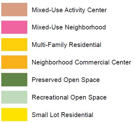
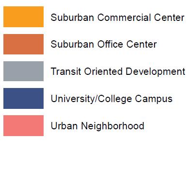
17 Mapping Future Land Use Qualifier Charlotte Place Types Preserve, Refuge, Cemetery Preserved Open Space Park/Open Space Historic Site, Greenway/Tributary, Park (Neighborhood, Community, Regional), Golfcourse, Recreation Center, Sports Complex, Tennis Facility Recreational Open Space All Uses Uptown Mobile Home Residential <= 8 DUA Residential = 8+ DUA (Single Use but Bldg Type may vary) Research Uptown Metropolitan Single Family Residential Single Family Residential Mixed Residential Civic/Medical/Institutional Institutional More than 50 ac. Civic/Medical/Institutional Institutional Industrial-Warehouse-Distribution Industrial 3 (Include Airport) Less than 50 ac. Absorbed by whatever place type surround three sides of the property Light Industrial Heavy Industrial Retail Outside Activity Center; Less than 15 ac. Neighborhood Commercial Center Retail Outside Activity Center; Greater than 15 ac. Suburban Commercial/Office Office 1, 2, 3, 4, 5 Outside Activity Center Suburban Commercial/Office MIX Wedge Mixed Use Activity Center Corridor Suburban Commercial/Office Mixed Use Activity Center Mixed Use Neighborhood Pedestrian Overlay District Mixed Use Neighborhood TOD - Residential, Employment, Mixed Corridor Mixed Use Neighborhood


18 Place Types: CONNECT City-wide


19 Mapping: Existing Land Use Place Type Existing Land Use Place Type


20 Mapping: Future Land Use Place Type Adopted Future Land Use Place Type

21 Development Ordinance & Policy Update: C o m m u n i t y O u t r e a c h D e v e l o p m e n t O r d i n a n c e & P o l i c y U p d a t e Approach Development Adoption Define goals, process and engagement plan Develop ordinance with public, stakeholder & technical review and engagement Complete public review & Council adoption 2016 January 2016 We July Are Here 2017 January 2017 June 2018 January 2018 June 2019 January Community Outreach Coordinated Virtual Go To Advisory Geographic Community-wide Reached 450 citizens and counting concurrent & on-going city meetings and events Charlotteudo.org information sharing, document review & comment, mapping tools, social media stakeholder interviews, existing groups, neighborhoods, and organizations selected committee for on-going advisory & technical review area specific workshops, mapping, UDO discussions open houses & forums 23

22 Place Types: Palette 25
Land Use Policy & Development Ordinance Update
 Land Use Policy & Development Ordinance Update Charlotte Chamber of Commerce, Land Use Committee July 27, 2016 Land Use Policy & Development Ordinance Update Land Use Policy & Development Ordinance Update
Planning Charlotte s Future. Planning Committee May 17, 2016
 Planning Charlotte s Future Planning Committee May 17, 2016 Place Types: Next Steps March - June Public Input: Education & input on community character and place-type framework Public open house (Transportation
Planning Charlotte s Future. Transportation & Planning Committee March 14, 2016
 Planning Charlotte s Future Transportation & Planning Committee March 14, 2016 Charlotte s Vision Livable city Vibrant economy Thriving natural environment Diverse population Choices for housing, education,
Citizen Advisory Group Meeting 5: Land Use April 14, 2011
 Citizen Advisory Group Meeting 5: Land Use April 14, 2011 Meeting Agenda 1. Background Review 2. Transportation Follow-up 3. PED Overlay Approach 4. Land Use Mapping 5. Group Exercise 6. Wrap-up and Next
INDEPENDENCE BOULEVARD AREA PLAN. Economic Development Committee Overview March 10, 2011
 INDEPENDENCE BOULEVARD AREA PLAN Economic Development Committee Overview March 10, 2011 Presentation Outline Purpose: To provide an overview of the Independence Boulevard Area Plan and to request a recommendation
INDEPENDENCE BOULEVARD AREA PLAN. Economic Development Committee Overview May 25, 2010
 INDEPENDENCE BOULEVARD AREA PLAN Economic Development Committee Overview May 25, 2010 Presentation Outline Plan Purpose and Development Process Draft Plan Policies and Implementation Strategies Request
ATTACHMENT A 09/12/2011. Attachment A - 1. A. Preliminary Future Transit Station Sub-area
 ATTACHMENT A A. Preliminary Future Transit Station Sub-area The Centers, Corridors and Wedges Growth Framework describes Transit Station Areas, which are sub-areas within Growth Corridors, as areas surrounding
The Five Components of the McLoughlin Area Plan
 The Five Components of the McLoughlin Area Plan This documents contains the complete language of the five components of the McLoughlin Area Plan: The Vision Statement The Values The Guiding Principles
TRANSIT ORIENTED DEVELOPMENT PINELLAS COUNTY MPO LIVABLE COMMUNITIES INITIATIVE PINELLAS COUNTY COMPREHENSIVE PLAN AMENDMENTS
 PINELLAS COUNTY MPO LIVABLE COMMUNITIES INITIATIVE MODEL LAND DEVELOPMENT CODE TRANSIT ORIENTED DEVELOPMENT PINELLAS COUNTY COMPREHENSIVE PLAN AMENDMENTS MPO Livable Communities Initiative Goal: Improve
INDEPENDENCE BOULEVARD AREA PLAN. June 24, 2008
 INDEPENDENCE BOULEVARD AREA PLAN Public Meeting #1 June 24, 2008 Tonight s Agenda Introduction Welcome and Ground Rules Overview Presentation Purpose of the Plan What Brings Us Here? A Tour of the Corridor
Tyvola & Archdale Transit Station Area Plan. May 15, 2008
 Tyvola & Archdale Transit Station Area Plan First Public Meeting May 15, 2008 Presentation Outline 1. Purpose and Process 2. Station Area Overview 3. Plan Recommendations Vision Land Use Transportation
INDEPENDENCE BOULEVARD AREA PLAN
 INDEPENDENCE BOULEVARD AREA PLAN Public Meeting October 28, 2008 Tonight s Agenda Introduction 4:00 4:05 Tom Warshauer Presentation 4:05 5:00 Blake Drury Group Exercises 5:00 5:50 All Wrap Up & Next Steps
Citizen Comment Staff Response Staff Recommended Revision Planning Committee
 Citizen Comment Staff Response Staff Recommended Revision Planning Committee Area No. 1: Owner desires retail land uses. Area No. 1a: Owner of two small parcels adjacent to Area No. 1 desires retail land
Lehigh Acres Land Development Regulations Community Planning Project
 Lehigh Acres Land Development Regulations Planning Effort Summary In July, 2010 Commissioner Frank Mann invited the Lehigh Acres community to start discussing how to achieve their recently adopted community
CITY OF PUYALLUP. Background. Development Services
 CITY OF PUYALLUP Development Services 333 South Meridian Puyallup WA 98371 To: City Council From: Katie Baker, AICP, Planning Division Re: South Hill Neighborhood Plan Adoption Date: (Meeting date: February
Centers, Corridors and Wedges Update. Public Meeting April 20, 2010
 Centers, Corridors and Wedges Update Public Meeting April 20, 2010 1. Welcome and Introductions Presentation Outline 2. The Original Centers & Corridors Concept 3. Why Does Charlotte Need an Updated Growth
1 October Dear Citizens of Charlotte and Mecklenburg County,
 1 October 2011 Dear Citizens of Charlotte and Mecklenburg County, As co-chairs of the Center City 2020 Vision Plan Steering Committee, we are proud to present the Center City 2020 Vision Plan, which sets
Tyvola & Archdale Transit Station Area Plan. June 5, 2008
 Tyvola & Archdale Transit Station Area Plan Second Public Meeting June 5, 2008 Presentation Outline 1. Purpose and Process 2. Station Area Overview 3. Plan Recommendations 4. Comments Received and Proposed
Prosperity Hucks Area Plan. Transportation and Planning Committee May 11, 2015
 Prosperity Hucks Area Plan Transportation and Planning Committee May 11, 2015 Presentation Outline 1. Background and Location 2. Community Dialog Process 3. Activity Center Recommendations 4. Wedge Recommendations
CHAPTER 3 VISION, GOALS, & PLANNING PRINCIPLES. City of Greensburg Comprehensive Plan. Introduction. Vision Statement. Growth Management Goals.
 CHAPTER 3 VISION, GOALS, & PLANNING PRINCIPLES Introduction The Greensburg Comprehensive Plan is intended as a working community document. A combination of long and short-term goals, this document is intended
Independence Boulevard Area Plan Planning Committee Public Comment May 18, 2010
 Independence Boulevard Area Plan Planning Committee Public Comment May 18, 2010 Presentation Outline Focus on Key Recommendations within Draft Plan Plan Purpose and Development Process Draft Plan Policies
FORMER CANADIAN FORCES BASE (CFB) ROCKCLIFFE SECONDARY PLAN. Official Plan Amendment XX to the Official Plan for the City of Ottawa
 ROCKCLIFFE SECONDARY PLAN. Official Plan Amendment XX to the Official Plan for the City of Ottawa") FORMER CANADIAN FORCES BASE (CFB) ROCKCLIFFE SECONDARY PLAN Official Plan Amendment XX to the Official Plan for the City of Ottawa 1 INDEX THE STATEMENT OF COMPONENTS PART A THE PREAMBLE PAGE Purpose...
FORMER CANADIAN FORCES BASE (CFB) ROCKCLIFFE SECONDARY PLAN Official Plan Amendment XX to the Official Plan for the City of Ottawa 1 INDEX THE STATEMENT OF COMPONENTS PART A THE PREAMBLE PAGE Purpose...
 Community Workshop #2 December 4, 2014 Team Tonight s Agenda 6:00 pm Welcome! 6:05 pm The Future of Downtown Tustin Ideas, Strategies and Recommendations 6:35 pm Questions and Comments 6:50 pm Open
ELK GROVE GENERAL PLAN VISION
 2-1 CHAPTER 2: 2-2 CREATING OUR The Community Vision for Elk Grove, expressed through a Vision Statement and a series of Supporting Principles, is a declaration of the kind of community that Elk Grove
CENTERS CORRIDORS WEDGES GLOSSARY
 Affordable Housing: Generally defined as housing for which the occupant is paying no more than 30 percent of their gross income for housing costs, including utilities. The City of Charlotte defines affordable
NORTH LAKE SPECIFIC PLAN AREA
 NORTH LAKE SPECIFIC PLAN AREA June 21, 2018 WELCOME Workshop Agenda Introduction Provide information about the program and introduce the team Background Information Share information about the North Lake
Rezoning Issues Setting a Foundation for Zoning Decisions
 Rezoning Issues Setting a Foundation for Zoning Decisions City Council Workshop May 2, 2016 Agenda Goal Need actionable items and sequence of steps Foundation for Zoning Decisions Council Workshop Discussion
CONTENTS 8.0 LAND USE 8.1 GENERAL LAND USE 8.2 RESIDENTIAL 8.3 MIXED USE 8.4 COMMERCIAL 8.5 EMPLOYMENT LANDS
 8-2 Land Use 8.0 LAND USE CONTENTS 8.1 GENERAL LAND USE 8.1.1 Uses provided for in all Land Use Designations 8.1.2 Uses prohibited in Hazardous Lands, Hazardous Sites and Special Policy Areas 8.1.3 Uses
Advisory Group Meeting #2
 Centers, Corridors and Wedges Advisory Group Meeting #2 December 16, 2008 Presentation Overview Advisory Group Process Feedback from Meeting #1 Preparation for Break-Out Groups Vision and Guiding Principles
Zoning Interface: Districts and Forms for Sioux Falls Zoning Ordinance
 Zoning Interface: Districts and Forms for Sioux Falls Zoning Ordinance For more information about each form, click on the associated link. Single-Family Residential Districts RR Rural Residential RS Single-Family
Remi Mendoza City Planning Academy March 13, 2017
 Remi Mendoza City Planning Academy March 13, 2017 1 What is the General Plan? The 2030 General Plan 5-Year Update (2035 General Plan) Questions and Answers 2 Guidebook for development and growth Required
2040 LUP is a part of the Comprehensive Plan and carries the same legal authority. Economic Challenges
 1.1. Guiding Anchorage s Growth Where will new residents settle over the next two decades? Where will people work, shop, and play? Will there be enough room to grow? How will Anchorage look? Will growth
Executive Summary. NY 7 / NY 2 Corridor
 Executive Summary NY 7 / NY 2 Corridor Transportation and Land Use Study December 2005 Prepared for: Town of Colonie Capital District Transportation Committee Prepared by: Introduction: Land use decisions
Urban Planning and Land Use
 Urban Planning and Land Use 701 North 7 th Street, Room 423 Phone: (913) 573-5750 Kansas City, Kansas 66101 Fax: (913) 573-5796 Email: planninginfo@wycokck.org www.wycokck.org/planning To: From: City Planning
ARTICLE 6: Special and Planned Development Districts
 ARTICLE 6: Special and Planned Development Districts 6-10 Traditional Neighborhood Development (TND) District 6-10.10 Purpose and Intent The Traditional Neighborhood Development (TND) District provides
North Downtown Specific Plan MEMORANDUM
 North Downtown Specific Plan MEMORANDUM MEETING DATE: November 13, 2017 TO: Members of the North Downtown Specific Plan Advisory Committee FROM: Jeanine Cavalli, Senior Planner SUBJECT: Materials for the
LAND USE MODEL UPDATE. Planning and Land Use Advisory Committee Meeting #2 September 4, 2014
 1 LAND USE MODEL UPDATE Planning and Land Use Advisory Committee Meeting #2 September 4, 2014 2 Presentation Outline Introduction and Recap Model Process Study Design Place Types Suitability Factors 3
Subregion 4 Central Avenue-Metro Blue Line Corridor Transit-Oriented Development (TOD) Implementation Project. Community Meeting April 27, 2011
 Implementation Project. Community Meeting April 27, 2011") Subregion 4 Central Avenue-Metro Blue Line Corridor Transit-Oriented Development (TOD) Implementation Project Community Meeting April 27, 2011 Overview Introduction to Subregion 4 TOD Implementation Program
Subregion 4 Central Avenue-Metro Blue Line Corridor Transit-Oriented Development (TOD) Implementation Project Community Meeting April 27, 2011 Overview Introduction to Subregion 4 TOD Implementation Program
SECTION UNIFIED DEVELOPMENT ORDINANCE SECTION Part 1 Ordinance. ARTICLE 1 Zoning Districts
 SECTION 1-100 UNIFIED DEVELOPMENT ORDINANCE SECTION 1-300 Part 1 Ordinance SECTION 1-100. Introduction. ARTICLE 1 Zoning Districts Crystal Lake strives to maintain a balance of various land uses for a
WEST LOOP DESIGN GUIDELINES CHECKLIST
 WEST LOOP DESIGN GUIDELINES CHECKLIST Section 1.0 General Strategies 1.1 DESIGN EXCELLENCE: ENCOURAGE HIGH QUALITY AND INNOVATIVE DESIGN OF NEW BUILDINGS WITHIN THE WEST LOOP WITHOUT BEING PRESCRIPTIVE
JWN PlanJam Workshop #1
 Planning for a healthy, vibrant neighborhood community JWN PlanJam Workshop #1 Presented by the Jefferson Westside Neighbors jwneugene.org More information on the Web at: jwneugene.org/infillstds Welcome!
Quarterly Report & Code Evaluation
 A New Zoning Code for a 21st Century Los Angeles To create livable communities, encourage sustainable development and foster economic vitality, we need a modern and user-friendly zoning code we need to
Planned Residential Neighborhoods Land Use Goals
 Planned Residential Neighborhoods Land Use Goals Issue: Guidelines that provide for diverse high quality residential areas that include a variety of housing styles and layouts are needed. Goal 1: Create
AWH REPORT OF THE PLANNING AND DEVELOPMENT DEPARTMENT FOR APPLICATION FOR REZONING ORDINANCE TO PLANNED UNIT DEVELOPMENT
 AWH REPORT OF THE PLANNING AND DEVELOPMENT DEPARTMENT FOR APPLICATION FOR REZONING ORDINANCE TO PLANNED UNIT DEVELOPMENT MAY 8, 2014 The Planning and Development Department hereby forwards to the Planning
4. Shape Transitions. 4. Shape Transitions
 4. Shape Transitions 49 Zoning District Policies Overall Intent: Maintain neighborhood character by creating compatible transitions that minimize land use conflicts. Strategy: Define the character of zoning
Request for Proposals: Architectural/Design Guidelines
 Request for Proposals: Architectural/Design Guidelines January 11, 2017 1.0 INTRODUCTION The City of Issaquah, Washington is soliciting proposals from qualified consulting firms to lead a community conversation
Public Meeting Final Recommendations August 8, 2013
 Public Meeting Final Recommendations August 8, 2013 Meeting Agenda 1. Existing Conditions 2. Plan Building Blocks & Process 3. The Plan Policies 4. What we heard 5. Next Steps Existing Conditions Existing
Ann Arbor Downtown Street Design Manual. Ann Arbor DDA IDA 2015 Awards Planning Category
 Ann Arbor Downtown Street Design Manual Ann Arbor DDA IDA 2015 Awards Planning Category 1 Ann Arbor s downtown streets are vibrant public spaces that accommodate multi-modal transportation, special events,
Silver Line CPAM UPDATE. Transportation and Land Use Committee October 14, 2016
 Silver Line CPAM UPDATE Transportation and Land Use Committee October 14, 2016 Purpose Recap Project History and Map Changes Provide Overview of CPAM Components Discuss Transportation Impacts Discuss Fiscal
SITE PLAN AREA. Met Park 6 Site Area (122,368 sf) Met Park 4/5 The Bartlett. Met Park 3 The Acadia. Met Park 2 The Millennium.
 Met Park 4/5 The Bartlett. Met Park 3 The Acadia. Met Park 2 The Millennium.") SITE PLAN AREA Met Park 4/5 The Bartlett Met Park 3 The Acadia Met Park 2 The Millennium Met Park 6 Site Area (122,368 sf) Met Park 1 The Gramercy Met Park 7 and 8 2 SUBJECT SITE Existing Use: Pentagon
SITE PLAN AREA Met Park 4/5 The Bartlett Met Park 3 The Acadia Met Park 2 The Millennium Met Park 6 Site Area (122,368 sf) Met Park 1 The Gramercy Met Park 7 and 8 2 SUBJECT SITE Existing Use: Pentagon
17.11 Establishment of Land Use Districts
 17.11 Establishment of Land Use Districts 17.11.010 Purpose. To promote the health, safety, and general welfare of City residents and those who come to South Salt Lake to work, exchange commerce and recreate.
University of the District of Columbia Van Ness Campus Master Plan Community Open House 3. December 8, 2010
 University of the District of Columbia Van Ness Campus Master Plan Open House 3 December 8, 2010 Introductions Sequence of Work: Campus Master Plan BEGIN: INTRODUCE AND START WORK Project Initiation Team
Welcome. Walk Around. Talk to Us. Write Down Your Comments
 Welcome This is an information meeting introducing the applications for proposed redevelopment of the Yorkdale Shopping Centre site at 3401 Dufferin Street and 1 Yorkdale Road over the next 20+ years,
I609. Penihana North Precinct
 I609. Penihana North Precinct I609.1. Precinct description The Penihana North Precinct is located south of the Swanson Railway Station, adjacent to the Rural Urban Boundary (RUB) and Waitakere Ranges Heritage
The transportation system in a community is an
 7 TRANSPORTATION The transportation system in a community is an important factor contributing to the quality of life of the residents. Without a sound transportation system to bring both goods and patrons
Establishment of Zoning Districts
 CHAPTER 6 Establishment of Zoning Districts 6. Section 601 Zoning by Districts: In accordance with the provisions of LUDMA that allows the Council to divide the area of the Town into Zoning Districts,
SAN RAFAEL GENERAL PLAN 2040 INTRODUCTION AND OVERVIEW
 SAN RAFAEL GENERAL PLAN 2040 INTRODUCTION AND OVERVIEW Steering Committee Presentation February 14, 2018 Purpose of General Plan Guide land use and development decisions Coordinate transportation, infrastructure,
Town of Liberty, NY COMPREHENSIVE PLAN & ZONING UPDATES
 Town of Liberty, NY S Public Informational Meeting October 4, 2016 High School Auditorium Welcome Thank you for coming tonight. Agenda Part I Overview of Proposed Changes What is Being Prepared Anticipated
North Fair Oaks Community Plan Summary and Information
 North Fair Oaks Community Plan Summary and Information WHAT IS THE NORTH FAIR OAKS COMMUNITY PLAN? The North Fair Oaks Community Plan is part of the San Mateo County General Plan, and establishes policies
1.0 Purpose of a Secondary Plan for the Masonville Transit Village
 Report to Planning and Environment Committee To: Chair and Members Planning & Environment Committee From: John M. Fleming Managing Director, Planning and City Planner Subject: Masonville Transit Village
M E M O R A N D U M SITE DATA
 Department of Community Planning & Economic Development 250 South 4 th Street, Room 300 Minneapolis, MN 55415-1385 M E M O R A N D U M TO: City Planning Commission, Committee of the Whole FROM: Lisa Steiner,
VILLAGE OF CLEMMONS PLANNING BOARD DRAFT STAFF REPORT
 VILLAGE OF CLEMMONS PLANNING BOARD DRAFT STAFF REPORT PETITION INFORMATION Docket # C-226 Staff Megan Ledbetter Petitioner(s) JBJH Properties, LLC Owner(s) JBJH Properties, LLC Subject Property 5892-49-1766
Chapter 4. Linking Land Use with Transportation. Chapter 4
 Chapter 4 Linking Land Use with Transportation Chapter 4 59 Chapter 4 Linking Land Use with Transportation Community Design and Transportation Program Introduction Since the 1950s, the predominant development
3.1 community vision. 3.3 required plan elements
 Chapter 3 Community Form 3.1 community vision 3.2 Parks & landscaping concepts 3.3 required plan elements D R A F T 20 Community Form Chapter 3 3.0 Community form 3.1 community vision The Specific Plan
Plan Framework Report. Attachment A
 Plan Framework Report Attachment A Uptown-Douglas Corridor Plan - Plan Framework Report Contents Introduction... 1 Planning Process... 3 Project Objectives... 4 Vision... 5 Community Values... 6 Structural
FOUR MILE RUN VALLEY WORKING GROUP AND CHARGE
 FOUR MILE RUN VALLEY WORKING GROUP AND CHARGE Adopted April 16, 2016 Amended July 19, 2016 Overview of Integrated Effort The overall goal of the Four Mile Run Valley (4MRV) initiative is to develop a comprehensive
Complete Neighbourhood Guidelines Review Tool
 Complete Neighbourhood Guidelines Review Tool Prepared By: City of Regina Planning Department October 2014 Page 1 of 14 Community Development Review Checklist for Secondary Plans and Concept Plans The
Citizen Advisory Group Meeting 8: Preliminary Recommendations June 23, 2011
 Citizen Advisory Group Meeting 8: Preliminary Recommendations June 23, 2011 Meeting Agenda 1. Background Review 2. Land Use 3. PED Overlay 4. Transportation & Streetscape 5. Group Breakouts 6. Wrap-up
ARLINGTON COUNTY, VIRGINIA
 ARLINGTON COUNTY, VIRGINIA County Board Agenda Item Meeting October 15, 2005 DATE: September 28, 2005 SUBJECT: Request to Advertise the adoption of the 2005 Clarendon Sector Plan C. M. RECOMMENDATION:
DRAFT. 10% Common Open Space
 % OF CHARLOTTE IS CATEGORIZED AS A. LAND USES : Placeholder map displaying location of Place Type GOALS: Accommodate XX% of future growth. Provide a concentration of primarily commercial and civic activity
Draft Cary Community Plan Review Part 3: Shop, Engage, Serve, Special Area Plans, Other Updates. October 27, 2015 Police Department Training Room
 Draft Cary Community Plan Review Part 3: Shop, Engage, Serve, Special Area Plans, Other Updates Committee for the Future October 27, 2015 Police Department Training Room AGENDA 1. Welcome and Call to Order
East Central Area Plan
 East Central Area Plan Steering Committee Meeting March 14 th, 2019 Tears-McFarlane House Community Room East Central Area Plan Steering Committee Meeting March 14, 2019 CHUN Tears-McFarlane House Community
Urban Design 9Identity
 Urban Design 9Identity URBAN DESIGN IDENTITY Urban design is about connecting people to their places through the built environment, nature, and overall urban form. Done well, it creates a memorable space
RESIDENTIAL DISTRICTS
 RESIDENTIAL DISTRICTS The residential district standards have been revised to reflect on-the-ground conditions, while continuing to respect the use patterns established within the neighborhoods. This will
2.0 THE PLATINUM TRIANGLE VISION
 2.0 THE PLATINUM TRIANGLE VISION The envisions an exciting future for the area surrounding Angel Stadium of Anaheim, the Honda Center and The Grove of Anaheim. 2.1 Planning Principles In order to further
Chapter 1: Introduction
 Chapter 1: Introduction The Penn Avenue Community Works Corridor Vision and Implementation Framework presents an integrated communitybased vision and a coordinated, long-term implementation framework for
Future Land Use SAMPLE RECOMMENDATIONS
 SAMPLE RECOMMENDATIONS Future Land Use The Future Land Use Chapter of the Master Plan builds upon prior chapters examining the existing conditions in their respective topic areas to present a comprehensive
Port Lavaca Future Land Use
 Port Lavaca Future Land Use Introduction The City of Port Lavaca is beginning to see sustained growth, after many years of relative stable population. New single family homes, apartments, and businesses
AMITY STATION Revised Concept Plan Review West Rosemary Street Chapel Hill, NC September 27, 2016
 AMITY STATION Revised Concept Plan Review West Rosemary Street Chapel Hill, NC September 27, 2016 DEVELOPER'S PROGRAM Introduction This is a request for review of a Revised Concept Plan by Chapel Hill
18 May 2016 CAMPUS MASTER PLAN UPATE
 18 May 2016 CAMPUS MASTER PLAN UPATE Council of the Deans ( Over view) AGENDA Engagement & What We Heard Focus Elements: 1. Development Framework Plan 2. Campus Mobility 3. Campus Guidelines 4. Wayfinding
Chapter 2: Vision, Goals and Strategies
 Chapter 2: Vision, Goals and Lake Elmo Today & Tomorrow Comprehensive Plan 2040 2 VISION, GOALS & STRATEGIES - DRAFT 4-6-2018 INTRODUCTION Comprehensive Plan Purpose Perhapse the most important objective
DALY CITY VISIONING PROCESS COMMUNITY WORKSHOP 3 MAY 8, 2008
 DALY CITY VISIONING PROCESS COMMUNITY WORKSHOP 3 MAY 8, 2008 PROCESS General Plan - a statement of the community s values, vision and aspirations for now and into the future... Timeframe LONG TERM - 2030
CHAPTER 1. Ms. Guajardo s Class - Central Elementary CH 1 1
 INTRODUCTION CHAPTER 1 Ms. Guajardo s Class - Central Elementary CH 1 1 1.1 SETTING South Centre City is a linear corridor south of Downtown Escondido paralleling Centre City Parkway and South Escondido
REQUEST Current Zoning: O-15(CD) (office) Proposed Zoning: TOD-M(CD) (transit oriented development mixed-use, conditional)
 (office) Proposed Zoning: TOD-M(CD) (transit oriented development mixed-use, conditional)") Rezoning Petition 2016-117 Zoning Committee Recommendation January 4, 2017 REQUEST Current Zoning: O-15(CD) (office) Proposed Zoning: TOD-M(CD) (transit oriented development mixed-use, conditional) LOCATION
Rezoning Petition 2016-117 Zoning Committee Recommendation January 4, 2017 REQUEST Current Zoning: O-15(CD) (office) Proposed Zoning: TOD-M(CD) (transit oriented development mixed-use, conditional) LOCATION
Planned Development Review Revisions (Project No. PLNPCM )
") Planned Development Review Revisions (Project No. PLNPCM2014-00139) Standard residential development Planned Development Example: Smaller lot sizes than what is allowed to create open space amenity. What
Planned Development Review Revisions (Project No. PLNPCM2014-00139) Standard residential development Planned Development Example: Smaller lot sizes than what is allowed to create open space amenity. What
Today s Agenda. Introduction to Camiros. Introduction to Zoning. Overview of Project Process Current understandings What we ve heard so far
 Today s Agenda Introduction to Camiros Introduction to Zoning Overview of Project Process Current understandings What we ve heard so far Public Comment Camiros Key Personnel Arista Strungys, AICP, PP Principal
Sustainable Growth. Sustainable Growth
 2 Sustainable Growth Sustainable Growth SUSTAINABLE GROWTH 2.1 COMMUNITY VISION... 2-5 2.2 THE CITY SYSTEM... 2-7 2.2.1 AREAS... 2-7 2.2.2 CITY-WIDE SYSTEMS... 2-8 2.2.3 PROVINCIAL PLAN BOUNDARIES AND
Town Center (part of the Comprehensive Plan)
") Town Center (part of the Comprehensive Plan) Mercer Island Town Center Looking North (2014) In 1994, a year-long process culminated in a set of design guidelines and code requirements for the Town Center
Town Center (part of the Comprehensive Plan) Mercer Island Town Center Looking North (2014) In 1994, a year-long process culminated in a set of design guidelines and code requirements for the Town Center
East Central Area Plan
 East Central Area Plan Steering Committee Meeting January 10 th, 2019 Tears-McFarlane House Community Room East Central Area Plan Steering Committee Meeting January 10 th, 2019 CHUN Tears-McFarlane House
LOW DENSITY RESIDENTIAL
 LOW DENSITY RESIDENTIAL Corner lots with coach houses to increase diversity, provide unity to the streetscape and increase eyes on the street. Garages and ancillary units accessed via rear lanes. Parking
Equitable Growth Through TOD Planning
 Equitable Growth Through TOD Planning Community Meeting # 2 November 2017 Goals Objectives Extend investment from downtown Connect neighborhoods physically and economically Enhance places based on local
FUTURE LAND USE ELEMENT
 FUTURE LAND USE ELEMENT GOAL I: To create and sustain a great place to live, play, and prosper Objective 1: The City of Ocala shall incorporate the principles and strategies of the Ocala 2035 Vision into
Noda Assemblage. Available Urban Infill Assemblage for Sale. Site. Corner of North Brevard & Charles Avenue Charlotte, NC 28205
 Available Urban Infill Assemblage for Sale Mattheson Avenue LYNX Light Rail Blue Line Extension Brevard Street Site Charles Avenue North Davidson Street Noda Assemblage Corner of North Brevard & Charles
Chapter 1.0 Introduction
 Chapter 1.0 Introduction 1.1 Background The North Metro commuter rail line is part of the RTD FasTracks regional transit system expansion program to build more than 100 miles of rail transit throughout
Visioning Statement and Guiding Principles
 Visioning Statement and Guiding Principles Planning for the Future The General Plan The General Plan represents Woodland's shared vision of the future and defines a path to lead the community toward its
JANUARY 19, 2011 CENTRAL AVENUE-METRO BLUE LINE TRANSIT-ORIENTED DEVELOPMENT IMPLEMENTATION PROJECT COMMUNITY FORUM
 CENTRAL AVENUE-METRO BLUE LINE TRANSIT-ORIENTED DEVELOPMENT IMPLEMENTATION PROJECT COMMUNITY FORUM JANUARY 19, 2011 THE MARYLAND-NATIONAL CAPITAL PARK AND PLANNING COMMISSION PRINCE GEORGE S COUNTY PLANNING
Date: April 10, 2017 City Council Work Session April 24, 2017: Status Report on the Comprehensive Plan Update and Transportation Master Plan
 AGENDA REPORT To: From: By: Honorable Mayor and City Council Members Warren Hutmacher, City Manager Sharon Ebert, Director Community Development Date: April 10, 2017 Agenda: City Council Work Session April
PORT WHITBY COMMUNITY
 PORT WHITBY COMMUNITY SECONDARY PLAN UPDATE COMMUNITY IMPROVEMENT PLAN URBAN DESIGN GUIDELINES September 2015 DRAFT PROPOSED AMENDMENT NUMBER # to the Whitby Official Plan PURPOSE: The intent of this Amendment
V. Vision and Guiding Principles
 V. Vision and Guiding Principles The Master Plan for the Powers Ferry Corridor seeks a foundation in the desires of the community. At times, various elements of the community offered opposing viewpoints,
SECTION ONE: INTRODUCTION. introduction
 introduction 1 INTRODUCTION Since it was first established in 1843 as a trading post for the Hudson s Bay Company, Victoria has evolved into a Provincial capital city that is recognized across Canada and