The Master Plan also identified a number of issues and these issues remain and if anything have become more acute since 1997.
|
|
|
- Morgan Lyons
- 5 years ago
- Views:
Transcription
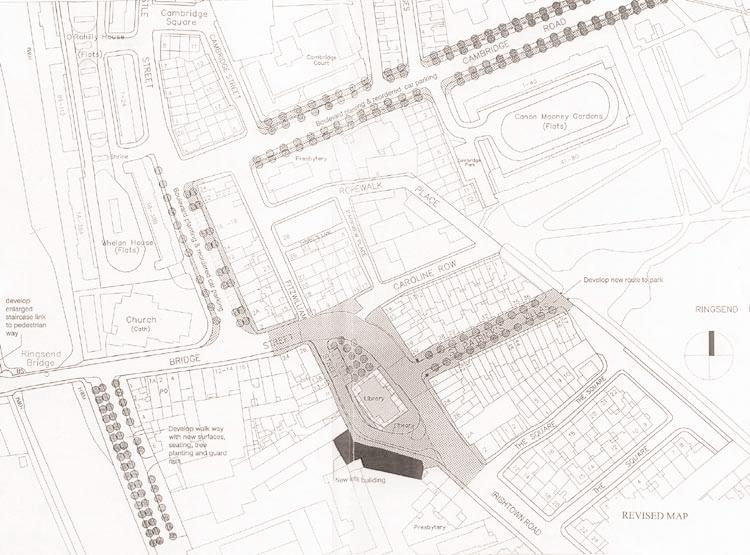
1 Ringsend AAP Introduction Dublin Docklands Area Master Plan (the Master Plan) identified a number, of areas within Docklands where more detailed planning would be appopriate. One of those areas is the Ringsend/Irishtown "village" centre and another is the section of the River Dodder as it flows through Docklands. These two areas are combined into this one study and are shown outlined on Map No. 1 and although the study concentrates on the two areas, the opportunity has been taken to look at a wider area of Ringsend/Irishtown. The "village" centre has a very clear identity and contains a range of retail, workshop, storage, community facilities, and residential uses. It also contains a number of interesting buildings, in particular the imposing Churches of St Patricks and St Marks and the public library, as well as good quality domestic architecture both old and new. The brightly painted retail buildings on both Bridge Street and Thorncastle Street have a picturesque townscape quality and the area around St Marks is particularly attractive. Pavements range in condition from poor to good and there is some unsightly wirescape which detracts from the "village". Dublin Corporation have carded out a number of civic improvements in the form of tree planting in various locations. Objective The main objective of the Study is to set out proposals for the enhancement of the Ringsend/Irishtown village centre as the centre for social and shopping activities for local communities, and the improvement of the River Dodder and its banks to provide a better amenity for the local population. Issues Land Use The Master Plan also identified a number of issues and these issues remain and if anything have become more acute since Land use in the "village" is very mixed and gives it a self-sufficient character. There is a real scarcity of available land or sites for development and existing lower value uses such as industry and workshops, are under pressure for change to private residential use. There have been a number of successful infill developments of affordable private housing and the pressure for this form of development and for future social housing is likely to increase. The difficulty of achieving this at a time of escalating site values and housing prices is acknowledged.
2 Civic Design Issues Ringsend/Irishtown is generally very coherent in a civic design sense, with attractive housing, largely of the two up, two down variety as well as some significant blocks of deck access flats. New buildings are likely to be infill in nature and will of necessity have to take their context into account. There are a number of critical sites which are currently in low-value use which are likely to change over time and this Plan is an opportunity to set down a framework for the future three- dimensional expression of new buildings in the area. The Ringsend shopping area, together with its church and library, has the potential to become an attractive civic space given the right interventions with new paving, landscaping and street furniture. Irishtown has a very attractive townscape quality and quite minor interventions could add to its visual amenity. Transportation Issues The area is bisected by heavy traffic, particularly along Bridge Street and Irishtown Road. While the traffic is likely to remain heavy for the foreseeable future, a number of measures envisaged will alleviate the 'problem. These include the emphasis on public transport, traffic calming, the improvement of the Bridge Street/Thorncastle Road junction and the ordering of road, pavement and parking bays. Strengths and Weaknesses The Master Plan also identified the strengths and weaknesses of the area and these are worth repeating and are as follows. Strengths The established residential community. The relative homogeneity, albeit of a low scale and relatively dense nature, of built fabric. The mixed use nature of the area with its living, working and recreational areas integrated in a selfsufficient manner. The extensive nature of public open space in a variety of forms, from riverside walks to seaside heritage areas and urban parks. The extensive sporting facilities in the area, including field sports and water-based activities. The under-exploited amenity resource of the River Dodder. Weaknesses Heavy traffic dividing the area, particularly heavy goods vehicles with associated problems of noise, fumes and danger. The scarcity of developable land to cater for any population growth in the area. The inaccessibility of a number of water bodies due to traffic arteries and dockside buildings. Poor passive policing of open spaces from peripheral vehicular routes and the absence of residential developments overlooking the main park with consequent security problems. Map 2 shows these strengths and weaknesses and Map 3 shows the land use zoning and specific proposals contained in the Master Plan. Map 4 shows the land use zoning and specific proposals contained in the Dublin City Development Plan 1999.
3 Master Plan Policies The Authority set out specific policies for Ringsend/Irishtown in the Master Plan, as follows: The Authority will seek to reinforce the mixed use nature of the area; coordinated policies and agencies to provide for the housing requirements arising from the natural growth of the existing communities; improve the village centre of Ringsend/lrishtown and Cambridge Road with new landscaping, paving, seating and lighting; improve the riverside walkways along the Dodder to form a (continuous) route from the Grand Canal Basin to Herbert Park, including the provision of a dedicated cycle path; encourage the provision of new social/affordable housing in strategic locations alongside Ringsend Park to improve the policing of the park; promote the introduction of a number of traffic-calmed precincts Proposed Initiatives Most of the works involved will be physical in nature and this study sets out particular proposals for the following: The realignment of roads and pavements to improve facilities for pedestrians and short-term parking. Aesthetic improvements in the form of new landscaping, seating and street lighting. The ordering and control of traffic passing through the area. The improving of access to Ringsend Park. The provision of a link between the "village" and the Grand Canal Dock area. Landscaping and improvements including the provision of a cycleway to the Dodder riverside. Possible sites for social/affordable housing. Townscape improvements. Archeology. Realignment of roads and pavements. The Area is fortunate in having some substantial roads which are not heavily trafficked and where space could be taken from the carriageway and given over to enlarged pedestrian areas which will also allow opportunities for tree planting, seating, and other amenity improvements. The two main roads where such improvements are proposed are Cambridge Road and Thorncastle Street at the section nearest Bridge Street.
4 Cambridge Road Cambridge Road has an average width of 14 metres (46 feet). The scale of buildings to either side is inconsistent, with buildings varying from one storey to four storeys and although most of these buildings are attractive in their own way, they do not provide a coherent enclosure to the street. Boundary conditions are eclectic and in some cases unsightly. One way of improving this is to use landscaping and ground finishes as the unifying elements which would provide an improved appearance to the street. It is therefore proposed to double the existing pavement widths on either side and provide strong boulevard street planting to supplement those trees already planted by Dublin Corporation. Designated car parking spaces can then be provided within this extended amenity strip but their visual impact will be screened by the tree planting. Sketch No. 1 shows the intended effect and is contrasted with a photograph of the existing road. Unsightly wirescape should be removed. Amenity lighting for the extended pavements using low level warm lighting will be required and it is recommended that a consistent style be adopted for the larger street lights. Thorncastle Street Thorncastle Street is particularly wide at its junction with Bridge Street and it is an area which has high quantities of pedestrians at particular occasions associated with the church and with the retail and business activities. Traffic on Thorncastle Street is relatively light and again there is an opportunity to provide for more pedestrian space to both the front of the church and to the front of the shops. Sketch No. 2 shows how the street might be improved. This again involves laying quality paving materials, providing new lighting, tree planting and seating. Consideration might also be given to licensing the pub/restaurants in the area to occupy part of the pavement in summertime. Irishtown Road Although heavily trafficked, the number of pinch points make singleline traffic the predominant pattern on the road and some opportunity exists for improving pavement widths with a view to them acting as traffic-calming devices. Wider pavements will also allow for more intensive tree planting which in turn provides both a psychological and physical barrier against heavy traffic for pedestrians. Ringsend Park Ringsend Park is one of the major assets in the area. However, it lacks a public presence in the sense of being highly visible to passers-by and is quite hidden from view. It is suggested that in order to improve this the presence of the park should be signalled at the entrance to St Patrick's Villas by constructing a named, gated "entrance" to advertise the park to encourage more frequent use. Interpretive panels could also be included as part of the entrance design which would inform people of the history of the park, its facilities, its species of trees and shrubs etc. Sketch No. 3 illustrates the proposal in outline form.
5 Link to Grand Canal Area The temporary bailey bridges erected at the time of the Tall Ships Race was indicative of the possibilities for more pedestrian movement and links that might be developed between the peninsula of land lying between the Liffey and Grand Canal Dock and the Ringsend/Irishtown area. The development of this peninsula will create a substantial residential population and the opportunity will exist for businesses in Ringsend to gain economically from the greater future population. In turn the existing community could take advantage of the hotel and restaurants facilities likely to be developed along Hanover Quay in the new redevelopment. A new pedestrian bridge is therefore proposed in a position similar to the position occupied by the bailey bridge along Thorncastle Street to the lock gates. Space would need to be made available from community controlled land and compensatory measures investigated and implemented. The Dodder Public access is currently available along the eastern side of the Dodder on Fitzwilliam Quay. However, the far side along by Shelboume Park Greyhound Stadium and the housing is in private ownership which makes it difficult to create a parallel route on the western side of the River between Ringsend Bridge and London Bridge. A similar problem exists in the area lying between Ringsend Bridge and the mouth of the Dodder whereas access exists on the western side, no access exists on the eastern side. It is proposed at the very least that the two stretches which do have pedestrian access be upgraded with more attractive paving, railings, tree planting and lighting. A cycleway should also be incorporated along the riverside route. Social and Affordable Housing The Authority is currently in con- sultation with Dublin Corporation with a view to identifying possible sites for acquisition or for development for sociallaffordable housing. It has to be recognised that there are very few possibilities in the area and given the escalation in site values it makes sense to first examine land in public ownership. Sites under investigation include, the pipe storage facility to the north of the existing pumping station, the area around the drain which is not part of the public park,small add-on single houses in the Bremen Road area. It is estimated that these lands could yield up to 50 housing units. Townscape Both Ringsend and Irishtown are fortunate in having a considerable amount of attractive domestic architecture and it is important that this be both conserved and developed. There is one critical site at the very heart of Ringsend, i.e. that site on Fitzwilliam Street behind the public library which is currently used for storage and workshop use. This particular area is zoned residential and is likely to be under pressure for redevelopment as private housing. The Authority will seek to apply its requirement for 20% of any redevelopment to be for social/affordable housing. However, there is a townscape issue and it is recommended that development on the Cambridge Road frontage be restricted to three storeys + attic, with the main building line following the back of pavement or near the back of the pavement. It is also recommended that the lower floors be used for retail or business use with the upper floors in residential use. Sketch No. 4 illustrates the appropriate scale for any such buildings. In addition this section of Cambridge Road is used effectively as a car park and it is recommended that the entire road and pavement be resurfaced so as to give dominance to the pedestrian abd confine parking to the areas allocated for cars.
6 The area contains a number of Residential Conservation Areas and many of the houses have been improved structurally and superficially (new roofs, replacement windows, doors, decorative materials etc.) in a manner which is unsympathetic to their design. The Authority would encourage property owners to improve or repair their buildings in a manner which is sensitive to the architecture. The Department of the Environment and Dublin Corporation have published very useful guideline documents to advise householders on how to refurbish their homes in visually sensitive areas. Archaeology Both Ringsend and Irishtown are included in areas which are indicated as being zones of archaeological interest in both the Master Plan and in the Dublin City Development Plan. The A authority supports the Corporation in its policies for such areas. Implementation Implementing the works will require the combined involvement of the community, local business interests, statutory service providers as well as Dublin Corporation and the Docklands Authority. The works proposed are quite extensive and will involve the expenditure of considerable sums of money. The Authority will seek to fund the development through its own resources and in cooperation with other relevant agencies such as Dublin Corporation who have particular legal responsibilities in relation to both housing and streets and pavements. It is envisaged that the work would be phased over a five year period. Consultation Following consideration of submissions made to the Authority, the following additional features are now proposed. 1. The enhancement and enlargement of the steps and area leading from Ringsend Bridge to the quayside north of the bridge as shown in sketch below. 2. The enlargernent of the new surface area to Irishtown Road which is designed to act as a traffic calming measure and which is now shown on A3 "Revised" Map. Implementation 5 Year Plan Yr. 1/2 Dodder Walk Thorncastle St. Ringsend Bridge/Steps and Floodlighting Yr. 3 Fitzwilliam St. Park Entrance Yr. 4 Cambridge Rd. Yr. 5 Remaining Works
7
Ringsend & Irishtown Local Environmental Improvement Plan
 Ringsend & Irishtown Local Environmental Improvement Plan Study Area East Link Bridge St. Patrick s Boat Club Ringsend Technical Institute Stella Maris Boat Club St. Patrick s Church Ringsend Library Ringsend
Rotherhithe Rotherhithe Area Vision Map
 Area Vision Map CWAAP1 Improved pedestrian and cycle links to the wider area Improved link from town centre to River Thames and docks CWAAP2 Brunel Museum NSP79 CWAAP3 Proposed Thames Crossing Station
6 Site Framework Strategies
 6 Site Framework Strategies 6.1 Introduction Section 6 identifies a number of specific areas which are considered to be key sites within the Plan area and which may have potential for development / redevelopment.
heuston gateway: sections heuston gateway: regeneration strategy and development framework plan
 B B1 A B1 B C A heuston gateway: sections B B1 C 117 4.3.3 Zoning The station is the central hub of the area and this function must be preserved and developed. However large areas of the Heuston Station
16. Peckham Peckham Area Vision
 16. 16.1. Area Vision 16.1.1. is: A lively town centre providing a range of daytime and night time activities on Rye Lane including a Library, a Leisure Centre and many independent retailers which specialise
EVALUATION OF MASTER PLAN ALTERNATIVES
 7 The Environmental Report is required to identify, describe and evaluate reasonable alternatives, taking into account the objectives and geographical scope of the Master Plan 2008. Three plan alternatives
6.0 Development of Amenities,
 6.0 Development of Amenities, conservation of architectural heritage and other features This chapter outlines the Area's significant potential to provide for amenities of city wide and local importance
Chapter 5 Urban Design and Public Realm
 5.1 Introduction Public realm is all areas of the urban fabric to which the public have access. It is where physical interaction takes place between people. It therefore, includes buildings and their design,
REPORT BACK BROADSHEET 3 May 2016
 Paddington Place REPORT BACK BROADSHEET May 06 Architects and planners should work with the community first and then thinking about developers profits second. - Quote from participant at Paddington Place
ILLUSTRATIVE MASTERPLAN
 ILLUSTRATIVE MASTERPLAN The Development Dairy Crest (Imperial College) The Proposed Development aims to create a new high quality residential neighbourhood, alongside a new public park for White City.
Animating the Rideau Canal December 2013
 Executive Summary Animating the Rideau Canal December 2013 Why study the Rideau Canal? The Rideau Canal has been an important part of Ottawa throughout its history, and has shaped and been shaped by the
The Area has been divided into specific development zones with different characteristics and ownership patterns. These are identified on Diagram 1.
 2CONTEXT 7 2.1 THE AREA The Grand Canal Dock Planning Scheme Area (Area) comprises the lands framing the inner and outer basins of the GCD. The land covers 29.2 hectares (72.1 acres) and the inner and
PART AOTEA PRECINCT
 CONTENTS... PAGE AOTEA PRECINCT...4 14.5.1 INTRODUCTION...4 14.5.2 RESOURCE MANAGEMENT ISSUES...4 14.5.3 RESOURCE MANAGEMENT OBJECTIVES AND POLICIES... 4 14.5.4 RESOURCE MANAGEMENT STRATEGY...5 14.5.5
PUTTING THE HEART INTO BATTERSEA. A vision
 PUTTING THE HEART INTO BATTERSEA A vision INTRODUCTION This document is a vision for creating a Battersea that its community can be proud of and it is about putting Battersea on the map. It is being proposed
Peckham Peckham Area Vision Map
 Area Vision Map PNAAP13 PNAAP8 Sumner Road Surrey Canal Walk Bird in Bush Park Key: NSP Site Allocations PNAAP Allocations Greenspace Low Line Cycle Network Primary Shopping Areas Square Surrey Canal Walk
Horwood Map of London, Westminster & Southwark First edition
 Barratt London is developing plans in tandem with Southwark Council and TfL to transform the southern end of Blackfriars Road. The residential-led, mixed-use scheme will deliver new private and affordable
Wide asphalt driveway abutting school property. garage built with incompatible materials, too close to park. incompatible fencing materials
 Wide asphalt driveway abutting school property incompatible fencing materials garage built with incompatible materials, too close to park Lack of plantings as a buffer between private property and open
Docklands SDZ: Views & Prospects Analysis. Dublin City Council Planning Department February 2013
 Docklands SDZ: Views & Prospects Analysis Dublin City Council Planning Department February 2013 1.0 AIM OF STUDY The aim of the Views and Prospects study is to identify existing and potential views of
3.2 EXISTING LAND USE. Landscape & Urban Design Framework
 3.2 EXISTING LAND USE Landscape & Urban Design Framework 26 3.2 EXISTING LAND OWNERSHIP 27 Poolbeg Awakens 3.3 PLOTS CONSIDERED WITHIN PLANNING BOUNDARY plots within Planning Scheme Boundary Landscape
March General enquiries: Web site:
 REDEVELOPMENT OF WILSON HOSPITAL FOR MITCHAM LOCAL CARE CENTRE Community Planning & Design Brief for Merton Clinical Commissioning Group and London Borough of Merton March 2016 1. Mitcham Cricket Green
Page 1 of 19 URBAN DESIGN FRAMEWORK FOR BOLTON STREET WATERFORD
 Page 1 of 19 URBAN DESIGN FRAMEWORK FOR BOLTON STREET WATERFORD 1.0 Introduction: The relocation of the City Council stores and depot from Bolton Street creates an exciting opportunity for development
4.00 STAKEHOLDERS. urbanprojects
 4.00 STAKEHOLDERS 94 heuston gateway: regeneration strategy and development framework plan 95 The Heuston Gateway presents one of the greatest concentrations of brown field development sites located adjacent
MOUNT AVENUE MASTERPLAN WORKING DRAFT NOVEMBER 2006
 MOUNT AVENUE MASTERPLAN WORKING DRAFT NOVEMBER 2006 1 1. OVERALL MASTERPLAN IDENTITY: Dun Dealgan motte and bailey The Dun Dealgan motte and bailey, a national monument, is located to the north east of
3.0 Area-Wide Strategies 30
 3.0 Area-Wide Strategies 30 3.6 Tourism Strategy This section of the plan aims to develop and improve the tourism potential of the area. Strategic Context The City Plan outlines the potential of Cork to
Woodbrook - Shanganagh
 Section 4: Key Sites Framework Strategy Woodbrook - Shanganagh Local Area Plan 2017-2023 4. Site Framework Strategies The Master Plans shall have regard to the thematic objectives under the LAP Development
STATEMENT OF OBJECTION TO THE PROPOSED DEVELOPMENT OF LAND AT CHURCH CLIFF DRIVE FILEY
 STATEMENT OF OBJECTION TO THE PROPOSED DEVELOPMENT OF LAND AT CHURCH CLIFF DRIVE FILEY You will be aware that Scarborough borough council have adopted a new local plan that includes land at Church Cliff
WELLINGTON HOSPITAL DESIGN GUIDE TABLE OF CONTENTS
 WELLINGTON HOSPITAL DESIGN GUIDE TABLE OF CONTENTS 1.0 Introduction Page 2 The Place of Wellington Hospital 2 The Future of the Hospital 2 2.0 The Intention of the Design Guide 3 3.0 Analysis 4 General
22.15 OUTDOOR ADVERTISING SIGNAGE POLICY
 22.15 OUTDOOR ADVERTISING SIGNAGE POLICY This policy applies to all land where a planning permit is required to construct or display a sign under the provisions of the Kingston Planning Scheme. 22.15-1
Clairtrell Area Context Plan
 Clairtrell Area Context Plan March 2005 Urban Development Services City Planning Contents 1. Introduction... 4 2. Development Structure... 6 2.1 Streets... 7 2.1.1 Sheppard Avenue and Bayview Avenue...
ARCHITECTURAL SERVICES DEPARTMENT
 ARCHITECTURAL SERVICES DEPARTMENT 25th August 2016: COUNTY ARCHITECT S REPORT FOR PART 8 DISPLAY / CONSULTATION Project Details - Part 8 Application DEVELOPMENT OF A NEW PUBLIC LIBRARY ON CASTLETYMON ROAD
Creating an integrated waterfront. Recommendations
 Creating an integrated waterfront Recommendations Railway Square Post Office + Shell Station Post Office Square Civic Square Ilot Green Wakefield St Wakefield St (Tory Cars) Wakefield St (New World Supermarket)
REFERENCE: 16/8568/ENQ Received: 25 October 2016 Accepted: 26 October 2016
 LOCATION: Allianz Park, Greenlands Lane, London, NW4 1RL REFERENCE: 16/8568/ENQ Received: 25 October 2016 Accepted: 26 October 2016 WARD(S): Mill Hill APPLICANT: Saracens Copthall Ltd. PROPOSAL: Extension
A. The sites in Table 16 below, as identified on the Policies Map, are allocated for retail-led development:
 SWDP 44: Worcester City Centre A. The sites in Table 16 below, as identified on the Policies Map, are allocated for retail-led development: Table 16: Sites Allocated for Retail-Led Development Policy Reference
Public realm strategy
 Mayor of London 71 new pedestrian bridge across the river strategic green links to the river Chapter 7 Public realm strategy new linear park improved road environment improved river walk indicative masterplan
Bourne Downtown Site Planning
 Prepared for: The Town of Bourne, MA In Cooperation with: Bourne Financial Development Corporation Prepared by:, Inc. June 24, 2009 Table of Contents Introduction and Summary... 1 Site Existing Conditions...
Development Control Plan
 Development Control Plan Liberty Grove Development Control Plan Date of Adoption: 4 September 2007 Effective Date: 7 March 2008 Index 1 INTRODUCTION... 3 1.1 NAME OF PLAN... 3 1.2 AREA TO WHICH THIS PLAN
30. Riverstown Mini-Plan
 County Development Plan 2017-2023 Consolidated Draft + Adopted Amendments August 2017 Volume 2, Chapter 30 Riverstown Mini-Plan 30. Riverstown Mini-Plan Village profile Riverstown is located approximately
Environmental Impact Statement
 Environmental Impact Statement of Development Proposals contained in the Planning Scheme for Docklands North Lotts August 2001 IRE 5.00 CONTENTS Non Technical Summary 1.0 INTRODUCTION 1 1.1 Background
DESIGN & ACCESS STATEMENT
 . DESIGN & ACCESS STATEMENT Site Adjacent to The Manor House, Upper Street,, Kingsdown, Deal, Kent. DESIGNS ARCHITECTURE + PLANNING CONTENTS Design and Access Statement Introduction Site and Location Planning
Town Center (part of the Comprehensive Plan)
") Town Center (part of the Comprehensive Plan) Mercer Island Town Center Looking North (2014) In 1994, a year-long process culminated in a set of design guidelines and code requirements for the Town Center
Town Center (part of the Comprehensive Plan) Mercer Island Town Center Looking North (2014) In 1994, a year-long process culminated in a set of design guidelines and code requirements for the Town Center
GUIDELINES BAYVIEW INSTITUTIONS CONTEXT PLAN LOCATION PLAN COMPONENTS URBAN DESIGN GUIDELINES
 Development in the Bayview Sunnybrook area will be consistent with the following urban design guidelines. They provide a framework for development in the area and are to be read in conjunction with the
Chapter 2: OUTLINE PLANNING APPLICATION PROPOSALS. A New Garden Neighbourhood Matford Barton 17
 Chapter 2: OUTLINE PLANNING APPLICATION PROPOSALS A New Garden Neighbourhood Matford Barton 17 2.1. SUMMARY AND STATUS OF THE PROPOSALS 2.1.1. The parameter plans and associated wording in this chapter
28. Coolaney-Rockfield Mini-Plan
 28. Coolaney-Rockfield Mini-Plan 28. Coolaney-Rockfield Mini-Plan Community facilities Community facilities in Coolaney-Rockfield consist of a primary school, crèche, community centre, sports field and
3.3. Urban Structure Defining a New Hierarchy of Routes and Spaces >Images
 Section 3.0 I The Masterplan Framework 18 >Images Examples of high quality routes and spaces 3.3. Urban Structure The success of any masterplan lies in a clear definition of the future urban structure
Newcourt Masterplan. November Exeter Local Development Framework
 Newcourt Masterplan November 2010 Exeter Local Development Framework Background The Exeter Core Strategy Proposed Submission sets out the vision, objectives and strategy for the development of Exeter up
Sub-committee on Harbour Plan Review of Harbour-front Enhancement Committee. Ninth Meeting
 Sub-committee on Harbour Plan Review of Harbour-front Enhancement Committee Ninth Meeting Date: 5 October 2005 Time: 3:30pm Venue: Conference Room 15/F, North Point Government Offices, 333 Java Road, North
DUBLIN DOCKLANDS MASTER PLAN AND RELATIONSHIP WITH OTHER PLANS
 .1 National Policy and Programmes.1.1 Sustainable Development A Strategy for Ireland, 1997.1.2 National Climate Change Strategy, 2007-2012.1. National Development Plan 2007-201.1.4 National Spatial Strategy,
Agenda. 7 Wright Crescent Urban Design Study. Public Meeting and Urban Design Workshop. 1 INTRODUCTION AND BACKGROUND (City of Kingston)
") Urban Design Study Public Meeting and Urban Design Workshop October 02, 2013 Agenda 1 INTRODUCTION AND BACKGROUND (City of Kingston) 2 URBAN DESIGN STUDY PRESENTATION (Antonio Gomez-Palacio, DIALOG) 3
Urban Design Study Public Meeting and Urban Design Workshop October 02, 2013 Agenda 1 INTRODUCTION AND BACKGROUND (City of Kingston) 2 URBAN DESIGN STUDY PRESENTATION (Antonio Gomez-Palacio, DIALOG) 3
Section Three, Appendix 16C Medium Density Housing, Design Assessment Criteria (Residential 8A zone)
") APPENDIX 16C MEDIUM DENSITY HOUSING, DESIGN ASSESSMENT CRITERIA (RESIDENTIAL 8A ZONE) PURPOSE OF APPENDIX 16C (RESIDENTIAL 8A ZONE) In the Residential 8A Zone the following are defined as restricted discretionary
APPENDIX 16C MEDIUM DENSITY HOUSING, DESIGN ASSESSMENT CRITERIA (RESIDENTIAL 8A ZONE) PURPOSE OF APPENDIX 16C (RESIDENTIAL 8A ZONE) In the Residential 8A Zone the following are defined as restricted discretionary
4. MASTERPLAN FRAMEWORK
 6a 6b 4. MASTERPLAN FRAMEWORK 6. Car Parks 6c Car Parks 6a and 6b will provide permanent parking. Area 6a will serve the foodstore with tarmac surfacing within a defined area to the west of the adjacent
Section Three, Appendix 17C Multiple Unit Housing Design Assessment Criteria
 APPENDIX 17C MULTIPLE UNIT HOUSING DESIGN ASSESSMENT CRITERIA Purpose of Appendix 17C In the Residential 9 Zone the construction and use of multiple household units located within the Multiple Household
01 the vision NEW LYNN IS WAITING FOR THE GREAT LEAP FORWARD
 [A] FRAMEWORK 01 the vision 02 the framework 03 urban design principles 04 c o n t e x t 05 issues a n d o p p o r t u n i t i e s 06 creating a t.o.d. 07 key recommendations 08 seven strategic areas of
Site 2 Development Brief
 a South Marketgait Site 2 b Union Street c Site 2 Development Brief Thomson Avenue (Northern Boulevard) Dundee Riverside Drive Discovery Plaza South Union Street Station Earl Grey Place West Site 5 Site
To the Lord Mayor and Report No. 312/
 To the Lord Mayor and Report No. 312/2017 Members of Dublin City Council Report of the Chief Executive Dublin City Council -----------------------------------------------------------------------------------------------------------
BORRISOKANE SETTLEMENT PLAN
 BORRISOKANE SETTLEMENT PLAN 1.0 General Introduction and Development Context Location Borrisokane is located 15km north of Nenagh on the N52. While the town is primarily residential, it acts as a market
Review of Opportunity Area C Draft Comprehensive Plan and Draft BOS Follow-On Motions. Special Working Group Meeting March 4, 2015
 Review of Opportunity Area C Draft Comprehensive Plan and Draft BOS Follow-On Motions Special Working Group Meeting March 4, 2015 The slides that follow identify where the draft Comprehensive Plan has
Next Steps / Development Process. Structure Plan. June submitted to City of Fremantle. Structure Plan. July supported for advertising
 overview What is today about? In July 0, the City of Fremantle resolved that the be advertised for public comment. Today is about: Understanding the history and context of the site Having your say on the
I615. Westgate Precinct
 I615. Westgate Precinct I615.1. Precinct Description The Westgate Precinct is located approximately 18km west of the Auckland city centre. There are seven Sub-precincts in the Westgate Precinct: Sub-precinct
Colchester Northern Gateway Master Plan Vision Review Draft. July 2016
 Colchester Northern Gateway Master Plan Vision Review Draft July 2016 Contents Introduction 4 Context 8 Purpose of the Report 8 Strategic Position 9 Overview of the Process 11 2012 Master Plan Vision 12
PUBLIC REALM STUDY AREA
 WELCOME PUBLIC REALM STUDY AREA WHAT IS PUBLIC REALM? Welcome to the Ballina Town Public Realm public consultation event. Mayo Council is in the process of producing a Public Realm Strategy for Ballina
YONGE STEELES CORRIDOR SECONDARY PLAN. Young + Wright / IBI Group Architects Dillon Consulting Ltd. GHK International (Canada) Ltd.
 Ltd.") PART A: PREAMBLE 1.0 PURPOSE The purpose of this Secondary Plan is to provide a development framework for intensification of the Yonge/ Steeles corridor including the north side of Steeles Avenue West
PART A: PREAMBLE 1.0 PURPOSE The purpose of this Secondary Plan is to provide a development framework for intensification of the Yonge/ Steeles corridor including the north side of Steeles Avenue West
City of Farmington. Downtown Plan. Amendment to the 1998 Master Plan Adopted October 11, 2004
 City of Farmington Amendment to the 1998 Master Plan Adopted October 11, 2004 Introduction Planning Background 1 Scope and Components of the Plan Amendment 2 Concept Introduction 3 Plan Concepts 3 Conceptual
Planning Districts INTRODUCTION
 INTRODUCTION To facilitate detailed examination of development prospects for all areas of the community, Delano has been divided into 14 planning districts. The location of these planning districts is
Boundaries and Fencing
 Boundaries and Fencing Introduction 7.1 The purpose of this chapter of the design code is to establish design principles and parameters to guide the development and erection of site boundaries within the
Land at Rampton Road. Cottenham
 Land at Rampton Road Cottenham Introduction TEP is preparing an outline planning application for 54 dwellings on 6.9 hectares of land adjacent to Rampton Road, Cottenham on behalf of the owners Cambridgeshire
Welcome to our exhibition
 Welcome to our exhibition The Homes & Communities Agency (HCA) welcomes you to this public exhibition explaining our proposals for the redevelopment of the former Lea Castle Hospital site. About the Homes
Downtown Streetscape Manual & Built Form Standards
 City of Guelph Downtown Streetscape Manual & Built Form Standards July 2014 Prepared by Brook McIlroy Inc. in association with Unterman McPhail Associates and McCormick Rankin Inc. City of Guelph Downtown
Longbridge Town Centre Phase 2 Planning Application
 Longbridge Town Centre Phase 2 Planning Application Non-Technical Summary of the Environmental Statement December 2013 Introduction A full application for Planning Permission has been submitted to Birmingham
0 9 Areas of Change 59
 09 Areas of Change 59 09 Areas of Change This section explores seven areas of change within Solihull Town Centre which provide practical interventions in order to deliver the emerging concepts outlined
Policies and Code Intent Sections Related to Town Center
 Policies and Code Intent Sections Related to Town Center The Town Center Vision is scattered throughout the Comprehensive Plan, development code and the 1994 Town Center Plan. What follows are sections
BLETCHLEY PARK AREA - DEVELOPMENT FRAMEWORK
 ANNEX A To Item 9 REVISED TEXT: additions shown bold and underlined, deletions in (brackets and in italics). BLETCHLEY PARK AREA - DEVELOPMENT FRAMEWORK This framework sets out the key objectives and requirements
Derry City and Strabane District Council Planning Committee Report
 Derry City and Strabane District Council Planning Committee Report COMMITTEE DATE: 23 rd March 2016 APPLICATION No: APPLICATION TYPE: PROPOSAL: LOCATION: APPLICANT: LA11/2015/0395/F Residential Development
C I T Y O F T O R O N T O L A W R E N C E A V E N U E E A S T S T U D Y. Northwest Corner of Birchmount Road and Lawrence Avenue East
 C I T Y O F T O R O N T O A P P E N D I X A Northwest Corner of Birchmount Road and Lawrence Avenue East 92 DILLON CONSULTING LTD. - J.C. WILLIAMS GROUP LTD. APPENDIX B LAWRENCE AVENUE EAST STUDY SUMMARY
Re: Draft Planning Scheme 2013 for the North Lotts and Grand Canal Dock
 DRAFT SUBMISSION Re: Draft Planning Scheme 2013 for the North Lotts and Grand Canal Dock Dear Sir/Madam I wish on behalf of the North Port Dwellers Association of Unit C, Liffey Trust Centre, 117-126 Sheriff
Huddersfield Urban Design Framework. 3. Framework
 3. Framework The illustrative plan has been used as the basis for developing an urban design framework and strategy in Part 3 of this report. This is based on a series of regulatory plans that code the
3/29 Rhu Marina Reporter David Russell. Body or person(s) submitting a representation raising the issue (including reference number):
 submitting a representation raising the issue (including reference number):") Development Plan Reference: 3/29 Rhu Marina Reporter David Russell The Council s submission to the Reporters starts on page 194 of the report. It is in four parts, 1. Summary of representations, 2. Modifications
Development Plan Reference: 3/29 Rhu Marina Reporter David Russell The Council s submission to the Reporters starts on page 194 of the report. It is in four parts, 1. Summary of representations, 2. Modifications
H7 Open Space zones. (a) provide for the needs of the wider community as well as the needs of the community in which they are located;
 provide for the needs of the wider community as well as the needs of the community in which they are located;") H7. Open Space zones H7.1. Background The majority of land zoned as open space is vested in the Council or is owned by the Crown. However some areas zoned open space are privately owned. While the open
H7. Open Space zones H7.1. Background The majority of land zoned as open space is vested in the Council or is owned by the Crown. However some areas zoned open space are privately owned. While the open
CLOUGHJORDAN SETTLEMENT PLAN
 CLOUGHJORDAN SETTLEMENT PLAN 1.0 General Introduction and Development Context Location The market town of Cloughjordan lies close to the border with Offaly at the junction of the R490 and R491 Regional
THE STORY SO FAR... THE STORY SO FAR...
 THE STORY SO FAR... Levitt Bernstein architects Levitt Bernstein are award winning architects who have designed many successful retail and residential projects. We are specialists in working with local
Strategic Environmental Assessment Screening Report. Dublin Port Masterplan Review 2017
 Strategic Environmental Assessment Screening Report Dublin Port Masterplan Review 2017 Table of Contents 1 Introduction... 1 2 Purpose of the Masterplan... 2 3 Task 1.1 Pre-Screening Check... 5 4 Task
The Proposed Auckland Unitary Plan (notified 30 September 2013)
") 3 Business zones Introduction There are 10 business zones in the Unitary Plan: City Centre Metropolitan Centre Town Centre Local Centre Neighbourhood Centre Mixed Use General Business Business Park Light
3 Business zones Introduction There are 10 business zones in the Unitary Plan: City Centre Metropolitan Centre Town Centre Local Centre Neighbourhood Centre Mixed Use General Business Business Park Light
SOUTH CAMBRIDGESHIRE DISTRICT COUNCIL. Planning and New Communities Director
 SOUTH CAMBRIDGESHIRE DISTRICT COUNCIL REPORT TO: Planning Committee 3 October 2012 AUTHOR/S: Planning and New Communities Director S/1723/12/OL CAXTON AND ELSWORTH OUTLINE APPLICATION FOR ERECTION OF RESTAURANT/TAKEAWAY
North Lotts and Grand Canal Dock
 Proposed Amendments North Lotts and Grand Canal Dock Planning Scheme 2014 February 2018 w ww Comhairle Cathrach Bhaile Atha Cliath Dublin City Council North Lotts and Grand Canal Dock SDZ Planning Scheme
2.0 Strategic Context 4
 2.0 Strategic Context 4 2.1 The Area Action Plan is a non-statutory plan, which forms a corporate policy document, expressing particular issues and areas of concern while also providing a vision for the
17. Coolaney-Rockfield Mini-Plan
 County Development Plan 2017-2023 Consolidated Draft + Adopted Amendments - August 2017 17. Coolaney-Rockfield Mini-Plan Village profile Coolaney is located approximately 23 km to the south-west of Sligo
Lancaster Conservation Area Appraisal. Character Area 8. Cathedral
 Lancaster Conservation Area Appraisal Character Area 8. Cathedral March 2013 118 3.8 Character Area 8. Cathedral 3.8.1. Definition of Special Interest "This character area is distinctive for the fine group
3.1 The hybrid planning application proposes the following description of development:
 CHAPTER 3: PROPOSED DEVELOPMENT 3.1 The hybrid planning application proposes the following description of development: Hybrid (part-outline/part-full) planning application for a single composite development
Development Brief Ursuline Convent, Blackrock, Cork
 Development Brief Ursuline Convent, Blackrock, Cork Comhairle Cathrach Chorcaí Cork City Council 2002 URSULINE CONVENT DEVELOPMENT BRIEF 1 INTRODUCTION AND MAIN OBJECTIVES... 3 1.1 The convent estate is
public spaces and accociated development
 4.0 Public Spaces and Associated Development The development must address appropriately the public spaces immediately adjoining it: the River Walkway and Parkgate Street. The development is also highly
A. WHAT IS A GENERAL PLAN?
 I. Introduction A. WHAT IS A GENERAL PLAN? A general plan is the planning guideline for the future of a city. It contains goals and policies which regulate urban development, the protection of the natural
5.1 Site Plan Guidelines
 5. Community Core Guidelines Development of the Community Core will take place by plan of subdivision and site plan approval. It will occur in a phased manner that will reflect the timing of residential
35. Gorteen Mini-Plan
 35. Gorteen Mini-Plan 35. Gorteen Mini-Plan Community facilities Community facilities in Gorteen consist of a crèche, community centre, sports field, church, burial ground and health centre. The former
The Planning Partnership Urban Design, Landscape Architecture, Planning, Communications
 The Planning Partnership Urban Design, Landscape Architecture, Planning, Communications WHAT WE HEARD Stakeholder Workshops One of the key components in the development of a Guelph-specific parkland dedication
97 Lea Bridge Road, Leyton, E10 7QL London Borough of Waltham Forest December 2015
 97 Lea Bridge Road, Leyton, E10 7QL London Borough of Waltham Forest December 2015 Public Realm and Landscape Proposals LEA BRIDGE ROAD, WALTHAMSTOW Public Realm & Landscape Proposals BDP(90)RPT001 December
Case Studies; Meitheal Clusters Applied to Villages and Rural Settlements
 Case Studies; Meitheal Clusters Applied to Villages and Rural Settlements 23.3.9 (ii) Case Studies, Meitheal Clusters applied to villages and rural settlments Fig 22.3.12 Cluster site plan; church opposite
LOW DENSITY RESIDENTIAL
 LOW DENSITY RESIDENTIAL Corner lots with coach houses to increase diversity, provide unity to the streetscape and increase eyes on the street. Garages and ancillary units accessed via rear lanes. Parking
CHARLES PUTMAN CHARLES PUTMAN AND ASSOCIATES, INC
 MEMORANDUM CHARLES PUTMAN & ASSOCIATES, INC. LAND DEVELOPMENT CONSULTANTS PLANNING ZONING PERMITTING 4722 NW Boca Raton Boulevard, Suite C-106 Boca Raton, Florida 33431 Phone: 561/994-6411 FAX: 561/994-0447
Poolbeg West SDZ Draft Planning Scheme
 Poolbeg West SDZ Draft Planning Scheme Introduction/vision Housing Community Economy/Employment Movement/transport Infrastructure green infrastructure /open space Land-use and phasing Public Realm Urban
Vision for Irvine: a self-confident town where people aspire to live and work and which they are proud to call home
 Vision for Irvine: a self-confident town where people aspire to live and work and which they are proud to call home Stunning view out to the harbourside Artist s impression of how the Bridgegate area could
Streets for All East of England
 Streets for All East of England Summary In 2017 Historic England published an updated national edition of Streets for All, a practical guide for anyone involved in planning and implementing highways and