Ocala 2035 Vision & Recreation & Parks Master Plan
|
|
|
- Jeffrey Crawford
- 5 years ago
- Views:
Transcription


1 & Recreation & Parks Master Plan Ocala City Council City-wide Kickoff Workshop May 18, 2010 City of Ocala June 8, 2010


2 Agenda I. Introductions II. Purpose of process III. Overview of Design Topics IV. Small Group Issue Identification V. Report Back to Entire Group


3 Introductions Leadership Group members City Staff VHB MillerSellen project team
4 Leadership Group members Albright, Steve Co-Chair, Urban Form and Public Spaces Property Appraisal Industry Homeowner in Southeast Ocala Parent of small children Baillie, Jaye Co-Chair, Building and Site Design Ocala/Marion County Chamber of Commerce Emerging Leaders of Ocala Retired Business Executives Group Fechtman, Dave Sales Management and Leadership Development Haynes, Narvella Front Porch (housing) SR40 Corridor, History & Education Governors West Ocala Revitalization YMCA Youth Achievers Ken Ausley Co-Chair, Urban Form and Public Spaces Construction Industry Banking Industry Education, Private School Dumond, Bob College of Central Florida Landscape Profession Gill, Summer United Way of Ocala Junior League of Ocala Emerging Leaders of Ocala Citizens Academy alumni 2008 Ingram, Thomas Banking
5 Leadership Group members (cont.) Johnson, Jerome Co-Chair, Building and Site Design Enterprise Zone SR40 Corridor, Design Sub-Committee Citizens Academy 2009 alumni Ledding, Nancy Marion Cultural Alliance Paolo Mastroserio Chair Civil Engineering Responsible Growth Reed, Ruth Homeowner in Northwest Ocala SR40 Corridor, Co-Chair Environmental/Community Activist Rudnianyn, Todd Co-Chair, Mobility and Connectivity Downtown Business Owner Resident in Northeast Ocala Jones, Ross Co-Chair, Recreation and Parks Recreation Commission Credit Unions Martinez, Gilbert Architect Michell, Dyer Healthcare Industry Senior Citizens Roberts, Fred Attorney at Law Yandle, Clark Co-Chair, Mobility and Connectivity North Magnolia Merchants Association Business Owner

6 Project Team Partners VHB MillerSellen Jim Sellen Rich Unger Curt Ostrodka David Perry Ray and Associates Planning & Environmental Bill Ray Looney Ricks Kiss Architects Mauricio Castro Dan Dixon Robert Charles Lesser & Co Melina Duggal
7 II. Purpose of To Establish Priorities for Future Decisions To describe what the Community wants the City to look like in 25 years o o o o How will people move around the community? How are the streets designed, used, and connected? What is the relationship of buildings to streets? What will the buildings, neighborhoods, commercial districts, and open spaces look like?


8 Leadership Group Mission Statement To create an avenue of approach fueled by a unified community vision that provides a path to enhance Ocala s quality of life.
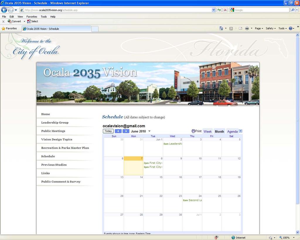
9 Schedule * Thursday, June 24: Leadership Group Meeting Urban Form and Open Space Thursday, July 15: Recreation & Parks Workshop Wednesday, July 21: Leadership Group Meeting Mobility & Connectivity Wednesday, August 4: Leadership Group Meeting Building & Site Design * Dates may be subject to change

10 Schedule * Friday & Saturday, August 6/7: City-wide Design Conference Friday Redevelopment and Neighborhood Sessions Saturday City-wide sessions and report back Tuesday, August 31: Final Leadership Group Meeting September: Leadership Group presents recommendations and report to City Council * Dates may be subject to change

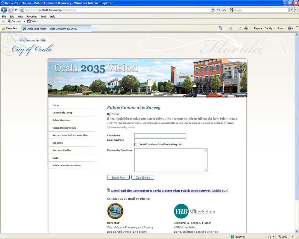
11 Schedule Presentations & Materials Previous Plans and Studies Public Comment and Survey
12
13
 New")

14 The Vision will provide the foundation for Public /Community Issues for the Evaluation and Appraisal Report (EAR) New Comprehensive Plan Land Development Code revisions Sub-area plans Recreation and Parks Master Plan Urban Form and Design Guidelines


15 Recreation & Parks Master Plan Facilities Inventory and Assessment Public Input Survey Community Workshop July 15 Recommendations for future development and programming
16 III. Overview of Design Topics I. Mobility & Community Connectivity II. Urban Form and Public Space III. Building and Site Design


17 Mobility & Community Connectivity Pedestrian and bicycle opportunities Roadway Design Transit
18 PLANNING STRATEGIES HISTORIC DESIGN PRINCIPLES Typical development pattern. Above ground utilities Low Density Development No parking in rear Single use district Narrow Sidewalks WIDE STREETS Source: Smart Growth America, Urban Advantage

19 Driver Expectation and Designing for Speed
20
21
22 Why this is essential! Pedestrian Fatalities & Speed 100 % Fatal to Pedestrians mph 30 mph 40 mph Speed

23
24 Catch 22

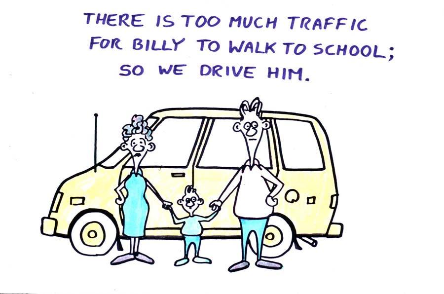
25 Schools Parents driving students and busing of students to school creates a 30% increase in morning peak hour traffic.

26 Conventional Suburban Conventional Suburban Auto dominant Separated use Single use zoning Low density All trips depend on the arterial Traditional Neighborhood Focus on pedestrian Mixed use Compact Multi-modal Less dependent on the arterial

27 Separated Land Use Residential Office Retail

28 Development for Walkability Conventional ¼ mile walk allows access to about 60 properties and one route. Traditional ¼ mile connects to properties and dozens of routes.


29 Benefits of Transit Oriented Development Job growth: near TODs typically 2 to 4 Times fasterthan-non-transit locations Higher property values: 15%-25% near transit Reduced automobile trips: by 50%

30

31 PLANNING STRATEGIES HISTORIC DESIGN PRINCIPLES Typical development pattern. Above ground utilities Low Density Development No parking in rear Single use district Narrow Sidewalks WIDE STREETS Source: Smart Growth America, Urban Advantage
 Pedestrian-friendly area Narrow driving lanes Below-ground utilities On street parking with rear parking")
32 PLANNING STRATEGIES NEW URBAN DESIGN PRINCIPLESNew Urban Development Pattern Street Trees Mixed-Use (Residential and Commercial) Pedestrian-friendly area Narrow driving lanes Below-ground utilities On street parking with rear parking

33 Relationship of Buildings to the Street


34 Urban Form and Public Space Public open spaces Relationship of land uses Building to street relationships Parking to building relationships

35 INSERT NEW DERICK SLIDE
36


37 PLANNING STRATEGIES NEW URBAN DESIGN It Is All About Creating Great People Places. Urban design principles are based upon creating pedestrian friendly spaces. The major tenants are pedestrian safety and comfort, interesting architecture, mixed uses and creating fun places. The human regains prominence over the automobile.

38 How can it all work together? Human size, or approximately 5 minute walk from the center of a neighborhood

39 How can it all work together? Blocks are short and provide multiple connections

40 How can it all work together? Parks and Open Spaces Include a mixture of land uses in the neighborhood, including a Center Neighborhood Centers Create a sense of place Civic Buildings
41


42 Live Work Residential Office School Office Grocery Main Street Mixed Use Residential Live Work Village Center Baldwin Park, Orlando, FL.


43 Baldwin Park, Orlando, FL.

44 School Main Street : Retail, Office, Residential Residential Residential Thornton Park Orlando, FL


45 Thornton Park, Orlando, FL

46 Residential Civic Square/Green Main Street Retail, Office, Residential Residential Haile Plantation, Gainesville, FL.

47 Haile Plantation, Gainesville, FL.


48 Building and Site Design Building massing, articulation, and form Signage Landscaping

49 INSERT NEW DERICK SLIDE

50 PLANNING STRATEGIES ADAPTIVE REUSE Fast food restaurant transformed into mixed use oriented to the street with a pedestrian scale. Galina Tahchieva from Dwell Magazine

51 PLANNING STRATEGIES ADAPTIVE REUSE Strip retail transformed into a mixed use with an orientation to the street, a pedestrian plaza and a transit stop. Galina Tahchieva from Dwell Magazine

52 PLANNING STRATEGIES NEW URBAN DESIGN Quality Architecture & Urban Design Emphasis on beauty, aesthetics, human comfort, creating a sense of place and human scale architecture. Endearing places need endearing attributes.
53 IV. Small Group Issue Identification All Issues identified by the public will be recorded Design-oriented Issues will be evaluated for incorporation into the Vision Other issues will be incorporated into the City s Evaluation and Appraisal Report (EAR)
54 Preliminary Issues include: SR 40 divides the community There is a lack of sidewalks, paths, and pedestrian/bicycle connections to schools, businesses and parks Regulatory barriers limit flexibility for site design There are too many fenced-in stormwater ponds at intersections and along roads
55 What Are Your Issues? Break into small groups All new Issues will be recorded Prioritize Issues using dots All Issues will be considered by the Leadership Group for incorporation into the Vision Report back to the entire group
56 What do you like? What do you want to change? What do you want to add?
57 City-Wide Design Conference (Tentative Schedule) Ewers Center Friday, August 6, 2010 Redevelopment and Neighborhood sessions (9:00 am to 3:00 pm) Saturday, August 7, 2010 City-wide sessions (9:00 am to Noon) Visit the Project Website:
Ocala 2035 Vision & Recreation & Parks Master Plan
 & Recreation & Parks Master Plan & Ocala City Council Recreation & Parks Master Plan May 18, 2010 Ocala City Council May 18, 2010 Overview I. Community Vision II. Recreation & Parks Master Plan What the
West Ocala Vision & Community Plan City Council Work Session. Presented by West Ocala Community Plan Steering Committee
 West Ocala Vision & Community Plan City Council Work Session Presented by West Ocala Community Plan Steering Committee November 29,2011 Ocala 2035 Vision West Ocala Community Vision & Master Plan West
EXISTING COMPREHENSIVE PLAN
 EXISTING COMPREHENSIVE PLAN Town Center Land Use Element: V. LAND USE POLICIES Town Center Mercer Island's business district vision as described in "Your Mercer Island Citizen-Designed Downtown" was an
Cobb County Design Guidelines Mableton Parkway & Veterans Memorial Highway Community Design Workshop January 12, 2017
 Community Design Workshop January 12, 2017 Agenda Opening Remarks / Introductions Scope of Work Existing Conditions Key Issues / Opportunities VPS Summary Draft Vision & Goal Statement Implementation Concepts
FUTURE LAND USE ELEMENT
 FUTURE LAND USE ELEMENT GOAL I: To create and sustain a great place to live, play, and prosper Objective 1: The City of Ocala shall incorporate the principles and strategies of the Ocala 2035 Vision into
City of Fort Lauderdale UPTOWN URBAN VILLAGE. Public Workshop December 7, 2016
 Public Workshop December 7, 2016 Workshop Agenda Introductions Project Presentation o o o History Project Scope/Timeline Character of Study Area o o o o Land Use Public Realm/Pedestrian Mobility Multimodal
PLAN ELEMENTS WORKSHOP. April 5, 2016
 PLAN ELEMENTS WORKSHOP April 5, 2016 needs more housing. But there is no one-size fits-all solution. Every neighborhood has its own character. In some places, density is not only appropriate it is badly
Information Session July 25, 2018
 Concord Pike (US 202) Master Plan Information Session July 25, 2018 1 Concord Pike (US 202) Master Plan 2018 Project Partners Wilmington Area Planning Council Delaware Department of Transportation New
Policies and Code Intent Sections Related to Town Center
 Policies and Code Intent Sections Related to Town Center The Town Center Vision is scattered throughout the Comprehensive Plan, development code and the 1994 Town Center Plan. What follows are sections
Wadsworth Boulevard S TAT I O N A R E A P L A N
 Wadsworth Boulevard S TAT I O N A R E A P L A N City of Lakewood Adopted November, 2006 The Vision The City of Lakewood s overall vision is to transform the area around the light rail station into a mixed-use
Sheridan Boulevard S TAT I O N A R E A P L A N S H E R I D A N B O U L E VA R D S TAT I O N A R E A P L A N
 Sheridan Boulevard S TAT I O N A R E A P L A N 1 City of Lakewood Adopted November, 2006 S H E R I D A N B O U L E VA R D S TAT I O N A R E A P L A N The Vision The City of Lakewood s overall vision is
City of Lake Mary, Florida. Evolution of a Historic Downtown with Transit Oriented Development Strategies
 City of Lake Mary, Florida Evolution of a Historic Downtown with Transit Oriented Development Strategies What is Transit Oriented Development? Walkable villages located at and around transit stations in
PLANNING COMMISSION WORKSESSION AGENDA. City Hall Second Floor Conference Room 9027 Center Street. July 1, :30 PM
 MEMBERS Harry J. Clark, Chairperson Bruce Wood, Vice-Chairperson Russell Harrison Ken Johnson Robert W. Schilpp Martha Wilson PLANNING COMMISSION WORKSESSION AGENDA City Hall Second Floor Conference Room
Blueprint Denver Task Force Meeting #
 Blueprint Denver Task Force Meeting #1 6.23.16 1. Welcome and Introductions Your name and affiliation Name 1 thing you love about Denver Name 1 thing you d change about Denver All in 30 seconds! Ready,
W O R K S H O P S U M M A R Y. Community Workshop #1: Visioning September 11th, 2007
 W O R K S H O P S U M M A R Y Community Workshop #1: Visioning September 11th, 2007 Upper Market Community Workshop Series and Design Plan Page 1 of 9 INTRODUCTION The Upper Market Community Workshop Series
Plano Tomorrow Vision and Policies
 Plano Tomorrow Vision and Policies PLANO TOMORROW PILLARS The Built Environment The Social Environment The Natural Environment The Economic Environment Land Use and Urban Design Transportation Housing
Citizen Advisory Group Meeting 5: Land Use April 14, 2011
 Citizen Advisory Group Meeting 5: Land Use April 14, 2011 Meeting Agenda 1. Background Review 2. Transportation Follow-up 3. PED Overlay Approach 4. Land Use Mapping 5. Group Exercise 6. Wrap-up and Next
Tyvola & Archdale Transit Station Area Plan. June 5, 2008
 Tyvola & Archdale Transit Station Area Plan Second Public Meeting June 5, 2008 Presentation Outline 1. Purpose and Process 2. Station Area Overview 3. Plan Recommendations 4. Comments Received and Proposed
Executive Summary. The Mebane CLP is not a regulatory document, but is intended to guide land development decisions. The plan includes:
 Executive Summary P URPOSE AND O RGANIZATION OF THE P LAN The City of Mebane, with input from citizens and an appointed CLP Advisory Committee, adopted Mebane by Design, a Comprehensive Land Development
CHAPTER 7: Transportation, Mobility and Circulation
 AGLE AREA COMMUNITY Plan CHAPTER 7 CHAPTER 7: Transportation, Mobility and Circulation Transportation, Mobility and Circulation The purpose of the Transportation, Mobility and Circulation Chapter is to
greenprint midtown SUSTAINABILITY ACTION PLAN 2012
 greenprint midtown SUSTAINABILITY ACTION PLAN 2012 MIDTOWN ALLIANCE SOUTHFACE ENERGY INSTITUTE RENAISSANCE PLANNING GROUP SUSTAINABLE ATLANTA PERKINS+WILL 2 GREENPRINT MIDTOWN 1. Introduction Sustainability
WELCOME and introduction
 1 WELCOME and introduction Mobility Hub Locations within Burlington STUDY OVERVIEW STUDY OBJECTIVES The City of Burlington is developing four Area Specific Plans, one for each of Burlington s Mobility
The GATEWAYS Sub Area Master Plan. City of Walker
 The GATEWAYS Sub Area Master Plan City of Walker Introduction: The Walker City Commission and Planning Commission decided in 2011 to create a sub-area master plan for the Remembrance Road and Wilson Avenue
Status Report: MD 355 Project
 Status Report: MD 355 Project OCTOBER 2006 M-NCPPC MONTGOMERY COUNTY PLANNING DEPARTMENT Summary of Community Comments, and break to the Results of the MD 355 Participation Session Brookside Gardens -
A BLUEPRINT FOR BROCKTON A CITY-WIDE COMPREHENSIVE PLAN
 A BLUEPRINT FOR BROCKTON A CITY-WIDE COMPREHENSIVE PLAN Public Meeting October 2016 1 Plan Summary and Discussion Public Meeting May 4 2017 City of Brockton Bill Carpenter, Mayor Department of Planning
PINE CURVE REZONING. BACKGROUND Purchased as two parcels in 2001 and 2002
 BACKGROUND Purchased as two parcels in 2001 and 2002 WHAT THE PROJECT IS AND IS NOT A Rezoning establishes the land use standards for Annexed and Zoned Greater Downtown District Historic Center September
Community Workshop. Tuesday, February 15, 2011 New Haven Free Public Library
 Community Workshop Tuesday, February 15, 2011 New Haven Free Public Library 1 Planning and Engineering Design Team PARSONS BRINCKERHOFF (PB) Lead Planning and Design NEWMAN ARCHITECTS Urban Architecture
Date: April 10, 2017 City Council Work Session April 24, 2017: Status Report on the Comprehensive Plan Update and Transportation Master Plan
 AGENDA REPORT To: From: By: Honorable Mayor and City Council Members Warren Hutmacher, City Manager Sharon Ebert, Director Community Development Date: April 10, 2017 Agenda: City Council Work Session April
V. Vision and Guiding Principles
 V. Vision and Guiding Principles The Master Plan for the Powers Ferry Corridor seeks a foundation in the desires of the community. At times, various elements of the community offered opposing viewpoints,
Town Center (part of the Comprehensive Plan)
") Town Center (part of the Comprehensive Plan) Mercer Island Town Center Looking North (2014) In 1994, a year-long process culminated in a set of design guidelines and code requirements for the Town Center
Town Center (part of the Comprehensive Plan) Mercer Island Town Center Looking North (2014) In 1994, a year-long process culminated in a set of design guidelines and code requirements for the Town Center
12/9/2013. HOLLYWOOD/PINES CORRIDOR PROJECT AMPO 2013 Annual Conference October 24, Our Perspective. Broward.
 HOLLYWOOD/PINES CORRIDOR PROJECT AMPO 2013 Annual Conference October 24, 2013 Our Perspective Broward Fort Lauderdale 1 Broward Metropolitan Planning Organization Fort Lauderdale Fort Lauderdale Skyline
DALY CITY VISIONING PROCESS COMMUNITY WORKSHOP 3 MAY 8, 2008
 DALY CITY VISIONING PROCESS COMMUNITY WORKSHOP 3 MAY 8, 2008 PROCESS General Plan - a statement of the community s values, vision and aspirations for now and into the future... Timeframe LONG TERM - 2030
Public Meeting Final Recommendations August 8, 2013
 Public Meeting Final Recommendations August 8, 2013 Meeting Agenda 1. Existing Conditions 2. Plan Building Blocks & Process 3. The Plan Policies 4. What we heard 5. Next Steps Existing Conditions Existing
Public input has been an important part of the plan development process.
 Lakewood s Comprehensive Plan recognizes that transportation helps shape the community, and that the way the community provides for the safe and efficient movement of people affects the character of the
Citizen Comment Staff Response Staff Recommended Revision Planning Committee
 Citizen Comment Staff Response Staff Recommended Revision Planning Committee Area No. 1: Owner desires retail land uses. Area No. 1a: Owner of two small parcels adjacent to Area No. 1 desires retail land
CHAPTER 3 VISION, GOALS, & PLANNING PRINCIPLES. City of Greensburg Comprehensive Plan. Introduction. Vision Statement. Growth Management Goals.
 CHAPTER 3 VISION, GOALS, & PLANNING PRINCIPLES Introduction The Greensburg Comprehensive Plan is intended as a working community document. A combination of long and short-term goals, this document is intended
Broadway District Specific Plan. Community Workshop #2 February 23,2016
 Broadway District Specific Plan Community Workshop #2 February 23,2016 1 Agenda Introductions Project Progress Status Upcoming Milestones Emerging Framework Land Use Urban Design Circulation Infrastructure
Transportation. Strategies for Action
 Transportation A major priority for the Overlake Neighborhood is to develop a multimodal transportation system. To achieve this system, a balance has to be found among travel, circulation and access needs;
RESEDA - WEST VAN NUYS COMMUNITY PLAN
 RESEDA - WEST VAN NUYS COMMUNITY PLAN Executive Summary As part of the initial outreach effort, the Department of City Planning hosted two workshops for the Reseda-West Van Nuys Community Plan Area during
Subregion 4 Central Avenue-Metro Blue Line Corridor Transit-Oriented Development (TOD) Implementation Project. Community Meeting April 27, 2011
 Implementation Project. Community Meeting April 27, 2011") Subregion 4 Central Avenue-Metro Blue Line Corridor Transit-Oriented Development (TOD) Implementation Project Community Meeting April 27, 2011 Overview Introduction to Subregion 4 TOD Implementation Program
Subregion 4 Central Avenue-Metro Blue Line Corridor Transit-Oriented Development (TOD) Implementation Project Community Meeting April 27, 2011 Overview Introduction to Subregion 4 TOD Implementation Program
Volume 2: Implementation Plan
 Volume 2: Implementation Plan February 25 th 2002 Implementation Introduction This document outlines the steps that should be taken to implement the Washington Heights Neighborhood Plan. The City Council
PINE CURVE REZONING. Property does not meet criteria for open space preservation and is not a candidate for a park
 PINE CURVE REZONING BACKGROUND Purchased as two parcels in 2001 and 2002 Annexed and Zoned Greater Downtown District Historic Center September 25, 2002 and October 7, 2002 WHAT THE PROJECT IS AND IS NOT
Atlanta BeltLine Subarea 3 Master Plan Update
 Atlanta BeltLine Subarea 3 Master Plan Update April 14, 2018 Workshop Meeting 1 22 miles, connecting 45 neighborhoods 22 MILES of transit 46 MILES of streetscapes and complete streets 33 MILES of urban
Guiding Principles, Objectives, Strategies and Policies
 Guiding Principles, Objectives, Strategies and Policies Section 1 Introduction These Guiding Principles were adopted as part of the 1999 Athens-Clarke County Comprehensive Plan and are carried over, in
Tyvola & Archdale Transit Station Area Plan. May 15, 2008
 Tyvola & Archdale Transit Station Area Plan First Public Meeting May 15, 2008 Presentation Outline 1. Purpose and Process 2. Station Area Overview 3. Plan Recommendations Vision Land Use Transportation
Welcome & Introductions
 Charrette Week Report Back - Thursday Evening April 25, 2013 Welcome & Introductions A New Master Plan Land Use and Circulation Putting data and information to work to create solutions for the master plan
Draft Memorandum #1: Goals and Vision for Revitalization
 Keizer Revitalization Plan Draft Memorandum #1: Goals and Vision for Revitalization Submitted to: City of Keizer April 12, 2018 (revised) Prepared By: Angelo Planning Group and Otak, Inc. Project No. 17482.A
WAC #7 3/14/14. Coachella General Plan Update
 WAC #7 3/14/14 Coachella General Plan Update Agenda 2 Introductions Public Draft General Plan Overview and Discussion of Next Steps Implementation and Evaluation Health Element Process Evaluation (discussion)
JANUARY 19, 2011 CENTRAL AVENUE-METRO BLUE LINE TRANSIT-ORIENTED DEVELOPMENT IMPLEMENTATION PROJECT COMMUNITY FORUM
 CENTRAL AVENUE-METRO BLUE LINE TRANSIT-ORIENTED DEVELOPMENT IMPLEMENTATION PROJECT COMMUNITY FORUM JANUARY 19, 2011 THE MARYLAND-NATIONAL CAPITAL PARK AND PLANNING COMMISSION PRINCE GEORGE S COUNTY PLANNING
SPRINGHILL LAKE TRANSIT VILLAGE
 Greenbelt Metro Area Sector Plan - Subarea Design Policies and Guidelines - Springhill Lake Transit Village 113 SPRINGHILL LAKE TRANSIT VILLAGE Residential Neighborhood and Village Center CONCEPT Springhill
Integrating Land Use and Transportation
 FEATURE Integrating Land Use and Transportation For years the transportation profession has emphasized mobility in the development of plans, programs, and projects. This emphasis on mobility moving people
CHAPTER 1. Ms. Guajardo s Class - Central Elementary CH 1 1
 INTRODUCTION CHAPTER 1 Ms. Guajardo s Class - Central Elementary CH 1 1 1.1 SETTING South Centre City is a linear corridor south of Downtown Escondido paralleling Centre City Parkway and South Escondido
International Blvd. TOD Plan Public Workshop #1
 International Blvd. TOD Plan Public Workshop #1 Add photos or project images September 21 and 22, 2010 Workshop Purpose Introduce the public to the Project Review and discuss the existing conditions analysis
7Page 91 CLEMMONS COMMUNITY COMPASS 7 COMMUNITY CHARACTER
 7 Community Character The beauty of Clemmons won t necessarily be a reflection of our past, but our future. This quote from Comprehensive Plan Steering Committee member Wayne Dodson captures the essence
TREASURE COAST REGIONAL PLANNING COUNCIL M E M O R A N D U M. To: Council Members AGENDA ITEM 5H
 TREASURE COAST REGIONAL PLANNING COUNCIL M E M O R A N D U M To: Council Members AGENDA ITEM 5H From: Date: Subject: Staff October 17, 2008 Council Meeting Local Government Comprehensive Plan Review Draft
SAFETY AND CONNECTIVITY IN A PLANNED COMMUNITY
 DALE CITY TLC SAFETY AND CONNECTIVITY IN A PLANNED COMMUNITY PROJECT KICKOFF MEETING MARCH 7, 2016 AGENDA 1. Introductions 2. Project Overview 3. Discussion 4. Site Visit PROJECT KICKOFF MEETING MARCH
Hillsborough County MPO Transit Study. Citizens Team Workshop Wednesday, February 28 th, 2006 Hillsborough Community College - Brandon
 Hillsborough County MPO Transit Study Citizens Team Workshop Wednesday, February 28 th, 2006 Hillsborough Community College - Brandon What is the MPO Transit Study? An effort to look at the full range
4.1.3 LAND USE CATEGORIES
 4.1.3 LAND USE CATEGORIES a. City Center District The City Center District incorporates the existing character and mix of uses in downtown Belmont to encourage redevelopment and new development in keeping
Economy Vision Statements: Social Wellbeing Vision Statements: Natural Environment Vision Statements:
 Economy Vision Statements: 1. Our business environment makes us a region of choice for new employers as we encourage entrepreneurship and have a vibrant, diversified and resilient regional economy. 2.
City of Farmington. Downtown Plan. Amendment to the 1998 Master Plan Adopted October 11, 2004
 City of Farmington Amendment to the 1998 Master Plan Adopted October 11, 2004 Introduction Planning Background 1 Scope and Components of the Plan Amendment 2 Concept Introduction 3 Plan Concepts 3 Conceptual
VIRGINIA / LAKE HIGHLAND TRANSPORTATION AND LAND USE STUDY
 VIRGINIA / LAKE HIGHLAND TRANSPORTATION AND LAND USE STUDY COMMUNITY MEETING #2 - PRESENTATION OVERVIEW 1 INTRODUCTION 2 CONTEXT STUDIES 3 VISION FRAMEWORK 4 DEVELOPMENT SCENARIOS 2 1 INTRODUCTION Project
City of Heath. Town Center Concept
 In the give-and-take of getting projects designed, financed, and approved, the famous refrain from the film Field of Dreams is heard often: if you build it, they will come. From the perspective of the
Workshop. Valley Vision Stanislaus. Our Schedule. Help Shape Our Region s Future! The Scenarios. Who is StanCOG? How Do I Select a Scenario?
 Valley Vision Stanislaus Workshop Help Shape Our Region s Future! Valley Vision Stanislaus is a long-range planning process that will link future land use with a framework for investment in roads, freeways,
SCTPO Project Summary September 2014
 A1A MULTIMODAL CORRIDOR PLANNING AND ENGINEERING ANALYSIS Florida Department of Transportation SCTPO Project Summary September 2014 PRESENTATION FOOTER Meeting Agenda What We Plan To Do Project Background
Bethesda Downtown Plan
 Bethesda Downtown Plan Planning Board Update Connecticut Avenue Location Economic Sustainability Social Environmental Scope Coming Soon! Team Listening, Twitter Outreach We Are Here Engagement Challenge
Urban Planning and Land Use
 Urban Planning and Land Use 701 North 7 th Street, Room 423 Phone: (913) 573-5750 Kansas City, Kansas 66101 Fax: (913) 573-5796 Email: planninginfo@wycokck.org www.wycokck.org/planning To: From: City Planning
Sherri Ferguson. President/CEO Portland Chamber of Commerce. Tennessee Certified Economic Developer Capstone Project
 Sherri Ferguson President/CEO Portland Chamber of Commerce Tennessee Certified Economic Developer Capstone Project Strategic Plan Development for the North Gateway of Portland, Tennessee The New Gateway
Hockessin Community Redevelopment Plan
 Hockessin Community Redevelopment Plan 3.1 Introduction The Community Redevelopment Plan for the Village of Hockessin is the result of the people s vision for a distinct village center that serves as the
Atlanta BeltLine. Subareas 9 & 10. Master Plan Updates. March 26, Washington Park Jamboree 1
 Atlanta BeltLine Subareas 9 & 10 Master Plan Updates March 26, 2018 Washington Park Jamboree 1 22 miles, connecting 45 neighborhoods 22 MILES of transit 46 MILES of streetscapes and complete streets 33
TABLE OF CONTENTS. Transportation Chapter 1 - Introduction and Purpose of Planning to 1-3. Utilities
 Chapter 1 - Introduction and Purpose of Planning... 1-1 to 1-3 Pennsylvania Municipalities Planning Code (Act 247)...1-1 Previous County Planning Activities...1-1 Objectives of the Plan...1-2 Elements
REVIEW AND EVALUATION OF REGIONAL LAND USE
 REVIEW AND EVALUATION OF REGIONAL LAND USE AND TRANSPORTATION SCENARIOS #220831 Environmental Justice Task Force October 7, 2014 VISION 2050 Process Development of Guiding Vision for Land Use and Transportation
Definitions. Average Daily Traffic Demand (ADT): The actual number or projected number of cars that pass a point in a 24-hour period.
: The actual number or projected number of cars that pass a point in a 24-hour period.") Definitions Access Management: A combination of physical techniques and transportation policies used to control the flow of traffic between roads and the surrounding lands. Alternative City Form Scenarios:
Definitions Access Management: A combination of physical techniques and transportation policies used to control the flow of traffic between roads and the surrounding lands. Alternative City Form Scenarios:
DOWNTOWN JACKSONVILLE MASTER PLAN S T R E E T H I E R A R C H Y
 DOWNTOWN JACKSONVILLE MASTER PLAN S T R E E T H I E R A R C H Y Gateway Intra-District Business Inter-District 44 CELEBRATING THE RIVER: A PLAN FOR DOWNTOWN JACKSONVILLE The Transportation Network This
Route 1 Corridor Study
 Route 1 Corridor Study Westbrook, Connecticut A Vision for the Connecticut Shoreline Public Informational Meeting July 28, 2015 Lower Connecticut River Valley Council of Governments Fitzgerald & Halliday,
Sewanee Village + Request for Builder/Developer Proposals
 Sewanee Village + Request for Builder/Developer Proposals Contact: Frank X. Gladu Special Assistant to the Vice Chancellor University of the South 735 University Ave Version 3 Sewanee TN 37383 Released:
Listening Sessions: Guiding Principles and Unified Development Code New Castle County, Delaware
 Listening Sessions: Guiding Principles and Unified Development Code New Castle County, Delaware March 2015 AGENDA Introduction: Who We Are Work Program and Schedule Guiding Principles Discussion Project
Gratigny Parkway East Extension Project Development & Environment (PD&E) Study
 Study") Gratigny Parkway East Extension Project Development & Environment (PD&E) Study Session 4: Presentation of Charrette Results December 8, 2010 MDX Work Program #: 92407 ETDM#: 11500 Project Location & Description
Gratigny Parkway East Extension Project Development & Environment (PD&E) Study Session 4: Presentation of Charrette Results December 8, 2010 MDX Work Program #: 92407 ETDM#: 11500 Project Location & Description
Rezoning. Rezone from C-4 and RA to RF-9C and RF-12C to allow subdivision into approximately 47 small single family lots in East Clayton.
 City of Surrey PLANNING & DEVELOPMENT REPORT File: 7903-0275-00 Rezoning Proposal: Rezone from C-4 and RA to RF-9C and RF-12C to allow subdivision into approximately 47 small single family lots in East
Silver Line CPAM UPDATE. Transportation and Land Use Committee October 14, 2016
 Silver Line CPAM UPDATE Transportation and Land Use Committee October 14, 2016 Purpose Recap Project History and Map Changes Provide Overview of CPAM Components Discuss Transportation Impacts Discuss Fiscal
DRAFT Subject to Modifications
 TREASURE COAST REGIONAL PLANNING COUNCIL M E M O R A N D U M To: Council Members AGENDA ITEM 8 From: Date: Subject: Staff May 19, 2017 Council Meeting Florida Department of Transportation Complete Streets
Secrest Short Cut and Monroe Expressway Small Area Plan AUGUST 29, 2018
 Secrest Short Cut and Monroe Expressway Small Area Plan AUGUST 29, 2018 Background and Process Monroe Expressway will be open by the end of 2018 Union County and Indian Trail identified a need to revisit
About Momentum Midland
 About Momentum Midland Achieving a community s full potential in terms of economic development and quality of life is critically important to its long term sustainability. Core to achieving this is a vibrant
Proposed Comprehensive Plan Strategies DRAFT for discussion June 28, 2017
 Proposed Comprehensive Plan Strategies DRAFT for discussion June 28, 2017 Land Use Rural Areas Refine the Farm and Forest area (FF) Update FF boundaries to account for existing lots less than five acres
ITEM #8. Regional Smart Growth Program. Regional Smart Growth Program. Presentation Overview. Coast Highway Vision and Stategic Plan.
 Regional Smart Growth Program Economic Development Commission What is Smart Growth? Adopted as part of the Regional Comprehensive Plan (RCP) RCP provides vision for region based on Smart Growth and sustainability
The State Road 7/U.S. 441 Collaborative. 8 th Annual New Partners for Smart Growth Building Safe, Healthy and Livable Communities
 The State Road 7/U.S. 441 Collaborative 8 th Annual New Partners for Smart Growth Building Safe, Healthy and Livable Communities J. Gary Rogers City of Lauderdale Lakes Florida Community Redevelopment
MURRAY CENTRAL STATION MASTER PLAN Central Station Area of Influence and Site Analysis
 CENTRAL STATION MASTER PLAN Central Station Area of Influence and Site Analysis OVERVIEW Planned Fire Station TAYLORSVILLE A thorough Site Analysis was conducted to ensure planning and design concepts
MONTGOMERY COUNTY METRO STATION AREA DESIGN CHARRETTE
 MONTGOMERY COUNTY METRO STATION AREA DESIGN CHARRETTE Shady Grove Metro Station Area Charrette Closing Presentation October 25-28, 2000 MONTGOMERY COUNTY, MD M-NCPPC Design Collective, Inc. Architects
Isabel Neighborhood Plan: Alternatives
 Isabel Neighborhood Plan: Alternatives Presented by: Lori Parks, Associate Planner February 2, 2015 Agenda 1. Background on BART to Livermore 2. Isabel Neighborhood Plan 3. Alternative Scenarios 4. General
FUNDING CORRIDOR REVITALIZATION
 FUNDING CORRIDOR REVITALIZATION Integrated corridor planning for the 21 st Century America Planning Association Annual Conference Atlanta, GA April 27, 2014 Mariia Zimmerman, MZ Strategies, LLC mariia@mzstrategies.com
Manhattanville Development Proposal: Project Description
 Manhattanville Development Proposal: Project Description Columbia University Community Board 9 Public Meeting, Tuesday, October 11, 2005 1 A Collaborative Process: Times and Topics Thursday, Oct. 6, 6:30
ORANGE COUNTY IMPLEMENTING THE FOUR C s
 ORANGE COUNTY IMPLEMENTING THE FOUR C s East Central Florida Corridor Task Force O R A N G E COUN TY P LA N N I N G DIVISION C O M M U N I T Y, E N V I R O N M E N T A L A N D D E V E L O P M E N T S E
The Five Components of the McLoughlin Area Plan
 The Five Components of the McLoughlin Area Plan This documents contains the complete language of the five components of the McLoughlin Area Plan: The Vision Statement The Values The Guiding Principles
Mountain View & Old Dixie Master Plans DACC Meeting. July 10, 2018
 Mountain View & Old Dixie Master Plans DACC Meeting July 10, 2018 Agenda I. Project Schedule II. Goals III. Design Workshop Our Team Sizemore Group: Award-Winning Planning and Architecture Principal: Bill
Transit / Housing Oriented Redevelopment
 Broward County Urban Planning and Redevelopment Department Kick-Off Meeting October 24, 2007 Transit / Housing Oriented Redevelopment 1 Future Land Use 2 Broward County Charter Voters approved in 1974.
Lehigh Acres Land Development Regulations Community Planning Project
 Lehigh Acres Land Development Regulations Planning Effort Summary In July, 2010 Commissioner Frank Mann invited the Lehigh Acres community to start discussing how to achieve their recently adopted community
Making Transit Oriented Development Work For Boonton, NJ
 Making Transit Oriented Development Work For Boonton, NJ Bloustein School of Planning and Public Policy Studio Dan Burton Loannie Dao Webster Slater Brandon Williams Ian Watson Maria Laham Nicola Mammes
Courtice Main Street Study Community Vision Workshop PLANNING SERVICES DEPARTMENT
 Courtice Main Street Study Community Vision Workshop PLANNING SERVICES DEPARTMENT July 22, 2009 Tonight s Meeting 7:00 pm Introduction David Crome, Director of Planning 7:05 Presentation Stasia Bogdan,
Neighborhood Districts
 NEIGHBORHOOD DISTRICTS SEVEN MAIN DISTRICTS Neighborhood Districts While the Development Plan provides a broad-scale overview of the neighborhood, this section focuses on uses and relationships at the
Issues Requiring Future Study
 Issues Requiring Future Study Transportation planning is an ongoing process that tends to identify new issues as it finds solutions for others. Some issues are so complex that a solution to one problem
3. VISION AND GOALS. Vision Statement. Goals, Objectives and Policies
 Vision Statement Queen Creek s interconnected network of parks, trails, open spaces and recreation opportunities provide safe and diverse activities and programs that sustain its unique, small town, equestrian