5 SOUTH YONGE STREET CORRIDOR STREETSCAPE MASTER PLAN STUDY DRAFT FINAL REPORT
|
|
|
- Andrea Summers
- 5 years ago
- Views:
Transcription
1 Report No. 1 of the Transportation Services Committee Regional Council Meeting of January 26, SOUTH YONGE STREET CORRIDOR STREETSCAPE MASTER PLAN STUDY DRAFT FINAL REPORT The Transportation Services Committee recommends: 1. Receipt of the presentation by Bruce Cudmore, EDA Collaborative and Angela Gibson, Head, Policy and Planning; and 2. Adoption of the recommendations contained in the following report dated December 19, 2012, from the Commissioner of Transportation and Community Planning. 1. RECOMMENDATIONS It is recommended that: 1. Council approve, in principle, the recommendations of the South Yonge Street Corridor Streetscape Master Plan Study as the basis for future development and streetscape design along this corridor. 2. The Regional Clerk forward this report to the Towns of Markham and Richmond Hill, and the City of Vaughan, with the request to endorse the recommendations of the South Yonge Street Corridor Streetscape Master Plan Study. 2. PURPOSE This report presents the findings and recommendations of the South Yonge Street Corridor Streetscape Master Plan Study from Steeles Avenue to Bantry Avenue. An Executive Summary of the South Yonge Street Corridor Streetscape Master Plan is provided in Attachment BACKGROUND Yonge Street is a critical Regional Corridor and will, with continued intensification, become increasingly important as a destination for business, entertainment and recreation The need for a Streetscape Master Plan for Yonge Street is identified in the Regional Official Plan (2010) and Streetscape Policy (2001), which recognizes Yonge Street as a
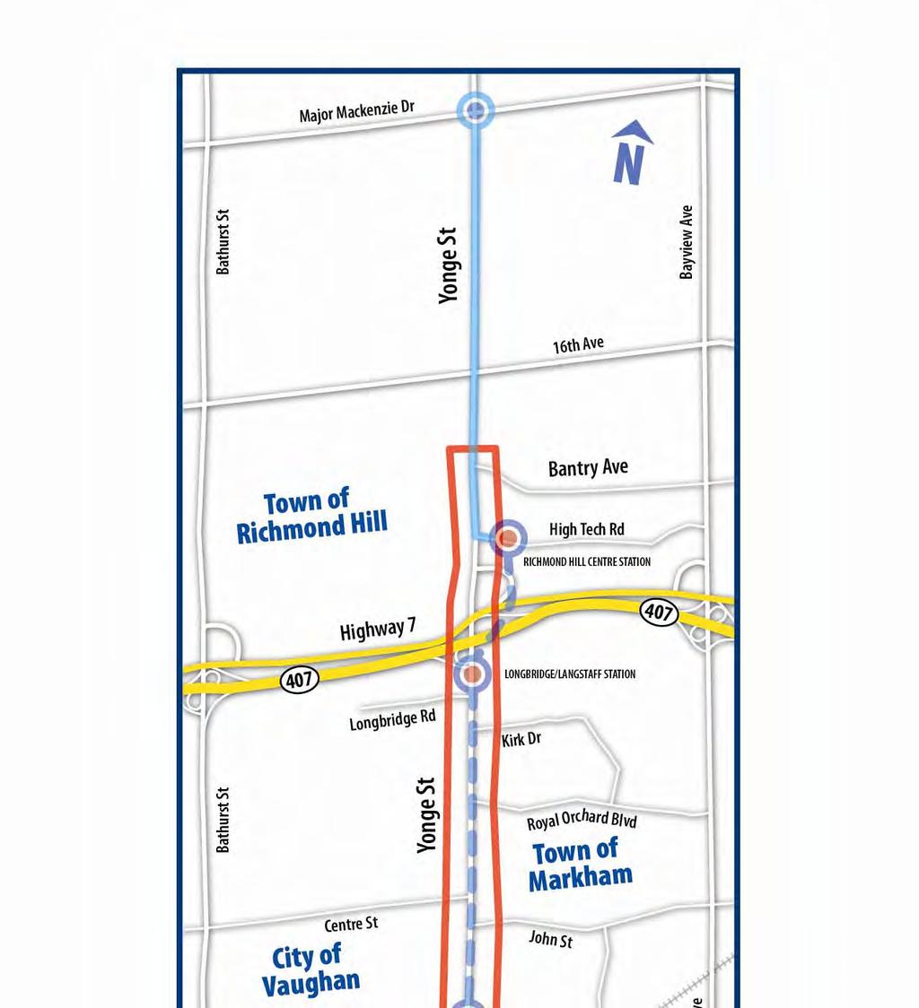
2 Report No. 1 of the Transportation Services Committee Regional Council Meeting of January 26, 2012 key Regional Corridor. Yonge Street will, therefore, require the highest quality urban design in order to attract a vibrant mix of housing, employment and recreation. The Region s vision of the corridor is consistent with the Province s Growth Plan (2006) and Metrolinx s The Big Move (2008). These policies identify Yonge Street as a higher order transit corridor, which will serve to support the Region s future Urban Growth Centres, in Richmond Hill/Langstaff and Newmarket. The Richmond Hill/Langstaff Gateway Mobility Hub is located in the northern portion of the South Yonge Street Corridor Streetscape Master Plan study area. A map of the study area context is shown in Attachment 2. The Streetscape Master Plan builds on the several land use studies carried out by local municipalities In response to the Provincial direction for Yonge Street, the Region and local area municipalities and the City of Toronto, have carried out several intensification, urban design, transportation planning and land use studies to guide development, built-form, and transportation along the corridor and Richmond Hill/Langstaff Gateway Mobility Hub. The Master Plan integrates the findings of six planning policy and infrastructure plans, 17 urban design and special studies and seven transportation studies to create one cohesive streetscape strategy for the entire corridor. The planning policy and infrastructure plans are shown in Table 1: Table 1 Planning Policy Studies (Local Municipalities) Local Municipality Study Year Town of Markham/ Thornhill Yonge Street Study 2002 City of Vaughan Town of Markham Yonge-Steeles Corridor Study 2008 Town of Markham Langstaff Area Land Use and Built Form Master 2009 Plan Town of Markham Yonge Street North Corridor Study Town of Richmond Richmond Hill Regional Centre Design and Land 2010 Hill Use Study City of Vaughan Yonge Street Area Study North/South 2010 Development proposals along South Yonge Street require a coordinated and consistent Streetscape Master Plan In support of Provincial direction for intensification along the Yonge Street corridor, coupled with the Yonge Subway extension, local municipalities and the Region have been receiving and increasing number of development applications for high-density
3 Report No. 1 of the Transportation Services Committee Regional Council Meeting of January 26, 2012 residential/mixed-use development, and anticipate seeing an accelerated number of these types of applications in the near future. As a condition of approval, developers have been required to implement, or contribute to, the streetscape treatment within the boulevard fronting their property. However, in the absence of a streetscape vision for South Yonge Street, the Region and the local municipalities have faced challenges in providing clear direction on the physical design of the boulevard or to be able to accurately estimate the value of a contribution toward such works. A consolidated Streetscape Master Plan will provide a framework and design direction for Regional and local planning staff, and the development community. This will help create certainty, and assist in expediting approvals for development applications. Three local Council Resolutions requested the Region lead the collaboration of a Streetscape Master Plan for South Yonge In early 2009, The Towns of Richmond Hill, Markham and the City of Vaughan passed resolutions requesting York Region undertake a streetscape study for South Yonge Street. In February 2010, Council approved $450,000 for the development of the South Yonge Street Corridor Streetscape Master Plan, between Steeles Avenue and Bantry Avenue, by re-allocating funds from the Municipal Streetscape Partnership Program (MSPP). The Region consulted and collaborated with the local municipalities and affected agencies to ensure that the recommendations of the previous studies were incorporated into the Scope of Work for the Master Plan. In 2010, the Region retained the services of EDA Collaborative, a landscape architecture consultant firm, to undertake the Study. 4. ANALYSIS AND OPTIONS Extensive stakeholder collaboration and consultation was part of the study process including presentations to local Councils and public meetings held in September A Project Core Team was developed to ensure collaboration on the development of the Master Plan. The Team was made up of Regional and local municipal representatives. Regional representation included Traffic Safety, Road Operations, Capital Delivery, Development Approvals, Community Planning, Infrastructure Planning, Forestry and York Region Rapid Transit Corporation (YRRTC). Local municipal representatives liaised with their internal departments and Council to receive input to guide decisionmaking. Agencies and stakeholders such as Powerstream, 407/ETR and City of Toronto were consulted at key milestones to inform them of the Study s progress as well as ensure consistency with their respective plans and policies.
4 Report No. 1 of the Transportation Services Committee Regional Council Meeting of January 26, 2012 At the streetscape design concept stage, presentations were made to local Committees of the Whole of Town of Richmond Hill, Town of Markham, and City of Vaughan on March 21, March 22, and March 29, respectively. Prior to the Public Information Sessions, York Region staff met with Local Councillors from Town of Richmond Hill, City of Vaughan, and Town of Markham on August 26, August 26, and August 31, to ensure local issues were addressed. In accordance with master planning requirements, facilitated Public Information Sessions were held on September 8 and 15, 2011 in Richmond Hill and Thornhill. Along with newspaper advertisements, all property owners along the study area corridor were notified directly. Several representatives of the development community were in attendance at the public meetings and staff also have met with individual site plan applicants to share details of the Plan. A copy of the published public notices is included in Attachment 3. Approximately 140 people attended both sessions and feedback was generally positive. There were some concerns raised about the lack of funding commitment for the subway and the proposed development densities. In addition to the required public meetings, approximately 250 residents were informed of the South Yonge Street Streetscape Master Plan at the Thornhill Village Festival on September 17 th Council members for the local municipalities attended both the Public Information Sessions, and the Thornhill Village Festival. The Master Plan envisions a Main Street that is Bold and Vibrant; Green and Sustainable; Practical and Achievable The study vision is to create a gateway destination that is vibrant and engaging; environmentally, socially and economically sustainable; consistent and complementary to the function of the corridor while supporting local character and partnerships. This will make South Yonge Street a place where people will travel to, rather than travel through. To achieve this vision, the Study outlines a streetscape design concept, detailed design guidelines as well as an implementation and phasing strategy that encourages an accessible, pedestrian-friendly streetscape. Continuity strip paving, illumination, street furniture, public art, way finding and signage will create a consistent and unified boulevard. Appropriate and context-sensitive roadway standards, including the width of travel lanes, inclusion of bicycle lanes, medians / centre left-turn lanes will be implemented in a way that complements the streetscape and roadway function. Figure 1 shows the components of the Streetscape Master Plan.


5 Report No. 1 of the Transportation Services Committee Regional Council Meeting of January 26, 2012 Figure 1 Streetscape Master Plan Summary The Master Plan addresses challenges and builds on opportunities within the corridor The Yonge Street corridor presents numerous challenges in designing the Streetscape Master Plan. Table 2 outlines the various challenges and how they were addressed in the Master Plan.
6 Report No. 1 of the Transportation Services Committee Regional Council Meeting of January 26, 2012 Table 2 Addressing Challenges Challenges Subway Uncertainty of funding and timing challenges ability to implement streetscape improvements in an economically feasible way Roadway Operations/Transit Inconsistent and constrained right-of-way (ROW) Maintain transit service in constrained corridor East-west pedestrian accessibility Local Cultural Neighbourhoods Varying unique neighbourhoods along the corridor Hydro Poles Visual impacts and physical barrier Lay-By Parking Reduces available boulevard space for streetscape improvements On-Street Parking Impedes traffic flow, impacts operations and level of service, occupies available ROW 407 On-Ramp Regional roadway design standards in conflict with MTO standards where jurisdictions overlap Multiple Jurisdictions Build consensus on consolidated streetscape vision Establishing roles and responsibilities (locals vs. Region) How addressed Phased approach to allow development to proceed: o Phase 1: Pre-Subway o Phase 2: (Ultimate) - Subway Streetscape design responds to ROW availability/context Sensitivity Analysis done to ensure impacts to level of service were mitigated/minimized Provision of safe pedestrian crosswalks emphasized by unique paving treatments Establish a consistent streetscape treatment and theme for the entire study area, while recognizing the unique character areas Plan accommodates either hydro above-ground or buried Strategically located lay-by parking adjacent to development No on-street parking (Lay-By only) to optimize traffic capacity and cycling lanes Agreement with MTO/407ETR for sharrows to continue on-street cycling facility Further negotiations with MTO regarding lane widths / cycling lanes Integration of previous local studies, Project Core Team involvement Consultation with Regional and local operations staff Local cultural neighbourhoods are preserved and integrated into the Plan There are five different character areas (or districts) along the Yonge Street corridor, ranging from urban to historic/heritage districts. Some areas along the corridor will remain stable, such as Old Thornhill Village and the Don Valley lands, and some will be


7 Report No. 1 of the Transportation Services Committee Regional Council Meeting of January 26, 2012 intensified, such as Yonge-Steeles Gateway and Richmond Hill Centre. These varying districts need to be acknowledged as distinctive, while having unified streetscape elements to create seamless and bold corridor. A Linked District Approach was used to recognize and consider the varying local character, plans, policies and features. The five different districts are connected with threshold zones which provide the transition between each district. Some streetscape elements may vary (such as street tree planting, location of medians and parking) to address the different character, however, consistent streetscape elements will be maintained to ensure that the overall streetscape is cohesive. The higher-density character of the Gateway districts (Yonge Steeles and Richmond Hill Centre) will be emphasized with a speciality paving palette and median treatments, street trees and plantings. The Clark Station and New Thornhill Village districts are urban transit station areas that will include street trees, speciality lighting and attractive entrances to the subway stations. The Old Thornhill Heritage district will use streetscape to integrate and enhance the heritage character through street tree and specialty plantings, special paving palette treatments, interpretative signage, speciality lighting and the provision of mid-block crossings, where applicable. The threshold areas generally act as open public and natural spaces that will be used to showcase natural views, landscape and public art by including seating areas, specialty planting, lighting and materials to make the areas more attractive and accessible.
8 Report No. 1 of the Transportation Services Committee Regional Council Meeting of January 26, 2012 Improvements will be phased to allow for a transition to the future Yonge Subway Extension The ultimate vision for the streetscape is based on the construction of the Yonge Subway extension. The Yonge Subway Extension Environmental Assessment (Finch Station- Richmond Hill Centre) was approved in April No funding announcement has been made at this time. In the absence of a decision for the funding of the subway extension, the Streetscape Master Plan is phased to allow for development along the corridor to proceed. The phased approach is efficient for the construction and operation of the corridor as well as maximizing the value of construction in the interim, while achieving an acceptable level of streetscape design to support development and enhance the corridor. Phase 1 (Pre-Subway) identifies areas of boulevard where implementation of the Streetscape Master Plan could potentially take place without compromising the roadway and traffic functions or that would require re-construction when the Subway (Phase 2 of the Master Plan) is built. Impacts to traffic and transit conditions were considered in the Streetscape Master Plan The proposed densities along Yonge Street will result in increased traffic congestion and delay for existing public transit, until the proposed Yonge Street subway extension is put into operation. The subway extension is critical to ensuring that mobility for existing and future residents of the area is maintained at an acceptable level of service. Traffic consultants, BA Group, sub-consultant to EDA Collaborative, worked with the Region s Traffic, Operations and Road Safety divisions to carry out a sensitivity analysis of the Streetscape Master Plan recommendations to ensure that the impacts of congestion on the level of service of Yonge Street and transit service were considered. The analysis confirmed that the streetscape recommendations did not affect the level of service along Yonge Street. Operational recommendations, such as the provision for cycling lanes/sharrows and lay-by parking, could be accommodated by the narrowing of traffic lanes. These recommendations made by BA Group are subject to further review with York Region Traffic, Operations and York Region Transit. Implementation of the Master Plan is primarily triggered by development, and involves coordination and contributions from a range of partners As development proposals are approved, the implementation of the streetscape elements will gradually be implemented. The Streetscape Master Plan recommends a standard treatment and approach to new development to ensure that as development occurs, the streetscape elements implemented along corridor will create a unified vision.
9 Report No. 1 of the Transportation Services Committee Regional Council Meeting of January 26, 2012 The Master Plan establishes a comprehensive implementation framework involving multiple stakeholders; where York Region, the local municipalities and a broad spectrum of partners including a variety of utilities (Powerstream, Ontario Power, Communications and Gas Companies, etc.), Highway 407/ETR, TTC, TRCA, existing and future land owners, developers and the business community will participate in a coordinated effort to enhance the primary urban corridor of York Region. Link to Key Council Approved Plans The 2011 to 2015 Strategic Plan identifies the South Yonge Street Corridor Streetscape Master Plan as contributing to Optimizing the transportation capacity and services in Regional Centres and Corridors. The Master Plan s objectives are consistent with and will serve to advance several goal areas of Vision The Master Plan also supports several Regional Official Plan policies including urbanizing the Region through intensification, building complete communities and vibrant streets. The Master Plan services population growth by encouraging alternative modes of travel and efficiently moving people and goods. 5. FINANCIAL IMPLICATIONS The cost of capital elements included in the Streetscape Master Plan will be approximately $45M over the life of the Plan, which is a level similar to other major streetscape projects in Ontario The projected cost to implement the Plan is representative and realistic given the time horizon of the Plan. In the absence of funding for the Yonge Subway Extension, the Master Plan anticipates an approximate 20-year period for the implementation of the plan (2031).The estimated annual average capital cost of implementing the streetscape improvements is $2.25M, for an approximate total of $45M over the 20-year timeframe. As development occurs along South Yonge Street, segments of the Streetscape Master Plan will be implemented incrementally. The Plan is based on a partnership model between York Region, local municipalities and the development community. To implement the Plan, various funding sources, including York Region s Municipal Streetscape Partnership Program, will be considered. The estimated capital cost of improvements and annual maintenance (in 2011 dollars) for the Streetscape Master Plan is summarized in the table below. These costs exclude the cost of underground power distribution, other utilities and public art.
10 Report No. 1 of the Transportation Services Committee Regional Council Meeting of January 26, 2012 Table 3 Cost of Streetscape Improvements Phase Total Cost of Streetscape Improvements* (excluding HST) Annual Maintenance of Streetscape (excluding HST) Phase 1 Pre-Subway $38M ($6.8M/km) $1.35M (245K/km) Phase 2 Subway $7M ($1.2M/km) $600K (105K/km) Total Cost $45M ($8.0M/km) $2.0M (350K/km) *These estimates exclude public art and underground power distribution and other utilities The cost of the South Yonge Street streetscape elements is comparable to other streetscape corridors. Enhanced streetscape projects within the Region (i.e. VivaNext Projects) can range from $6.1M up to $7.1M per km. On a smaller scale street, such as Main Street in Grand Bend, a high quality streetscape improvement cost approximately $3.5 - $4M ($5.7M per km). Streetscape improvements along Bloor Street, in Toronto, cost approximately $20 - $25M ($12.4M per km). York Region is working with local municipalities on reviewing levels of streetscape service and maintenance Council has adopted standards for streetscaping on Regional roads in order to maintain consistency in appearance and costs. As the Master Plan is implemented through site plan development on Yonge Street, the Region would continue to maintain the grass boulevard (where applicable), street trees, intersection treatments, medians and YRT improvements. The Regional cost to maintain the streetscape will be monitored and reflected in future operating budget submissions. Local municipalities would be responsible for the maintenance of streetscape features that exceed the Regional standard. These streetscape features include lighting, enhanced paving, public art, street furniture, lay-by parking, specialize planting, gateway features and signage. York Region staff are collaborating with local municipalities to review maintenance practices and discussing acceptable levels of service. The outcome of these discussions will provide a more accurate cost estimate for annual streetscape maintenance. An Implementation Strategy Team will be established to implement the Streetscape Master Plan The Implementation Strategy Team, comprised of Regional and local municipal staff, will coordinate, monitor, and facilitate development approvals, and recommend the operations and maintenance standards for this corridor. The team will ensure that the
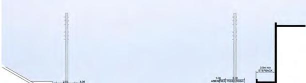
11 Report No. 1 of the Transportation Services Committee Regional Council Meeting of January 26, 2012 implementation of the streetscape master plan is implemented consistent with the Master Plan vision. A Terms of Reference will be developed to outline the mandate of the team. Existing hydro lines pose a financial, physical and visual barrier in creating an urban streetscape Existing above-ground hydro lines detract from, and could potentially impede, the overall streetscape vision for the corridor. Through consultation with Powerstream, it was determined that the burial of hydro lines is technically feasible, but with a high cost, costing an additional $62M, excluding HST. The Master Plan recommends that, where funding is available, accommodating the burial of hydro lines is ideal. York Region is not in a financial position to fund the burial, therefore, without partnership funding from development and/or subway construction, the hydro lines would remain above ground. Funding and partnership opportunities will be pursued to maximize investment in streetscape initiatives in the South Yonge Street corridor In order to achieve the overall vision for the corridor, it is important that funding and partnership opportunities be leveraged. Partnerships with the development community, private sector and local municipalities will be vital to ensuring the successful implementation of the streetscape plan. York Region and the development community could mutually benefit from the following tools to ensure the implementation of streetscape elements within the right-of-way fronting development. Municipal Streetscape Partnership Program (MSPP) The Municipal Streetscape Partnership Program is a significant source of funding that is dedicated to streetscape enhancements on regional roads to encourage partnerships with local municipalities for a higher level of streetscape design and should be considered as source of funding for South Yonge Street. Under this program, projects are initiated by local municipalities with the condition that they are to assume the maintenance of streetscape enhancements. Business Improvement Areas (BIA) Business Improvement Areas are operated by an elected board and funded through the property tax base. One focus of the BIA is to attract business and create a vibrant destination by improving their image through streetscape design. The City of Toronto has a capital cost sharing program model which provides matching capital funding to undertake streetscape improvements. The same model could be established between the businesses along Yonge Street and the local municipalities.
12 Report No. 1 of the Transportation Services Committee Regional Council Meeting of January 26, 2012 Development Charges The Development Charges Act allows municipalities to impose Development Charges which are estimated on the anticipated amount, scale and location of development as well as the increase in service requirements to accommodate future growth. Planned streetscape enhancements to the Yonge corridor are likely to be subject to Development Charges. Section 37- Bonusing In addition to Development Charges, developers could benefit from Section 37 of the Planning Act which enables local municipalities to grant additional height and/or density ( Bonusing ) for proposed development in exchange for community benefits, such as streetscape treatments. Section 37 is supported by the Regional Official Plan and is based on partnerships between the Region and area municipalities. A full review of existing and potential development opportunities for sites fronting on, or in proximity to, the Yonge Street corridor will determine where there are opportunities for bonusing. Site Plan Approval Site plan approval standards are set by municipalities, including York Region, that become applicable to new development through agreements upon which planning approvals are based. In this manner, there is the opportunity for the Region and the local municipalities to apply the Mater Plan streetscape standards to new development on a site-by-site basis in the South Yonge Street Corridor. Gas Tax Fund There are two sources of gas tax funding one Provincial and the other Federal. Provincial funding is specifically targeted for growth initiatives directly related to transit services and is currently included in the YRT/Viva operating budget, however both operating and capital initiatives are eligible. York Region receives approximately $14M in Provincial gas tax funding annually. The Federal Gas Tax fund provides funding for environmentally sustainable municipal infrastructure projects (ESMI) and capacity building, Presently, these funds are included in the Transportation Services capital budget and amounted to approximately $27M in Municipal partners would also have the option to apply a portion of their federal gas tax funding to these initiatives. There are several components within the Master Plan that would be potentially eligible for funding through these two sources. Alternative Funding Sources While not directly applicable to the general, or usual funding sources for streetscape there may be other non-conventional sources and/or partnerships that should be investigated, including, 407/ETR, CN Rail, Hydro One, environmental partnerships with Toronto Region Conservation Authority or private sponsors for public art.
13 Report No. 1 of the Transportation Services Committee Regional Council Meeting of January 26, LOCAL MUNICIPAL IMPACT Master Plan will be led by the Region and managed through partnerships with local municipalities and the private sector The implementation of the Streetscape Master Plan will require collaboration and support from local municipal partners. A clear process and communications plan between the Region, local municipalities and private sector will need to be established early to ensure a coordinated process for the approval of development and special projects As part of the Site Plan Approval process, Region and local municipal staff will be responsible to ensure that development will conform to the guidelines of the South Yonge Street Corridor Streetscape Master Plan. To ensure that streetscape improvements are implemented along Yonge Street, the Region will secure costs for these works based on cost estimates provided by the development and cross referenced with the Capital Cost outlined in the Master Plan. If it is deemed inappropriate to implement the streetscape works at the time of development, the Region may take a cash contribution in lieu of the works, based on the same principles noted above. All securities or cash contributions will be administered and secured by York Region. Local municipal annual operating budgets will need to be adjusted to allow for sufficient contingency to support maintaining the boulevard and streetscaped medians. 7. CONCLUSION Strong partnerships are essential to achieving the bold, sustainable and vibrant vision for South Yonge Street Yonge Street is a higher-order transit and intensification corridor which supports the Richmond Hill-Langstaff Gateway Mobility Hub. The Towns of Markham, Richmond Hill and City of Vaughan requested the Region undertake a streetscape study to develop a vision for the corridor. The Region collaborated with local municipalities and stakeholders to develop a bold, sustainable and achievable streetscape vision. The Master Plan is phased to provide design direction in order to ensure an efficient transition between today s reality and the future Yonge Subway extension. This will help expedite approval processes for development applications while meeting the objectives of the South Yonge Street Corridor Streetscape Master Plan. For more information on this report, please contact Angela Gibson at Ext The Senior Management Group has reviewed this report.
14 Report No. 1 of the Transportation Services Committee Regional Council Meeting of January 26, 2012 (Attachment 1 referred to in this clause was included in the agenda for the January 11, 2012 Committee meeting and is not re-printed for this Agenda. Please bring the attachment from the January 11, 2012 Committee meeting to Regional Council.) (Attachments 2 and 3 referred to in this clause are attached to this report.)
15 PRESENTATION South Yonge Street Corridor Streetscape Master Plan Presentation to Transportation Services Committee Angela Gibson, Head, Policy and Planning Bruce Cudmore, EDA Collaborative January 11, 2012 Key Study Objectives Establish a bold Vision Develop Detailed Design Guidelines and Standards Develop an Implementation and Phasing Strategy Transportation Services Committee / January 11, 2012 Slide 2


16 Policy Context Bantry Ave. Town of Richmond Hill Town of Markham 3 Municipalities 6 Planning Policy/Infrastructure Plans 17 Urban Design and Special Studies 7 Transportation Studies City of Vaughan N Steeles Ave. Transportation Services Committee / January 11, 2012 Slide 3 Project Core Team Region and Local Staff Stakeholders Powerstream, MTO/407ETR, City of Toronto, Local Politicians Public Stakeholder Consultation Public Information Sessions Slide 4
17 Stakeholder Consultation Dates Regional Committee: March 2, 2011 Local Committees: Richmond Hill: March 21, 2011 Markham: March 22, 2011 Vaughan: March 29, 2011 Meetings with Local Ward Councillors: Richmond Hill: August 26, 2011 Vaughan: August 26, 2011 Markham: August 31, 2011 Public Information Meetings/Festival: Richmond Hill: September 9, 2011 Markham/Vaughan: September 15, 2011 Thornhill Village Festival: September 17, 2011 Slide 5 Study Components Transportation Services Committee / January 11, 2012 Slide 6
18 Work Plan Phase 1: Phase 2: Phase 3: Phase 4: Phase 5: Research, Site Inventory & Analysis Vision Statement & Design Principles/ Objectives Streetscape Concept Plan/ Pre-Subway Plan Detailed Design Guidelines & Standards Implementation Strategy, Documentation & Confirmation AUG 2010 OCT NOV MAR 2011 AUG OCT Transportation Services Committee / January 11, 2012 Slide 7 Stakeholder Involvement South Yonge Street Corridor Streetscape Master Plan Study Presentation: Phase 3, 4, and 5: Design and Implementation Strategy


19 Vision: Bold, Sustainable, Achievable Slide 9 Contextual Planning Time short / medium / long term Transit decisions, funding, and on-going development York Region and local municipalities will collaborate and take ownership on implementing the vision Plan for tomorrow, build for today Bloor Street Viaduct Designed / built subway added
20 Yonge/Steeles District Slide 11 Old Thornhill Village Slide 12


21 New Thornhill Slide 13 Highway 407 to Bantry Slide 14

22 Pre-Subway/Subway Phasing Phase 1 Short Term: Pre-Subway Condition B: Use Existing Curbs Condition C: Implement Ultimate in Pre-Subway Period Condition D: Wait until Road Narrowing Possible Phase 2 Mid-Term: Subway Construction Condition A: Subway Open-Cut Construction Zones Phasing Summary Matrix Phase 1: Pre-Subway CATEGORY TASK York Region Strategies and Initiatives Design and Construction Align + Harmonize Plans Coordinate Among Utilities Discussion, Coordination + Negotiation w/ Stakeholders Discuss Operations + Maintenance Agreement Process for Public Art Policy Establish Funding Sources + Mechanisms Confirm Early Implementation Priorities Coordinate w/ Subway Design Coordinate w/ Private Developers Coordinate w/ BRT Design Prepare Detailed Streetscape Designs Local Municipal ities Richmond Hill Stakeholders Toronto

23 Capital Cost Comparison-Bloor Street Bloor Street BIA: Church Street to University Avenue, Cost: $25,000,000 overall / $12.4 million per km Main Street, Grand Bend, Ontario Cost: $4,000,000 overall / $5.7 million per km Phasing Plan Costs Shared Capital Costs: Local, Region, Private Sector Streetscape Cost Pre-Subway Plan Subway Plan $38-million $45-million Notes: 1. Subway Plan capital costs are incremental, not in addition to Pre-Subway Plan capital costs. 2. Utility duct and hydro line burial costs are not included in the Streetscape Costs

 Ultimate")

24 Capital Cost Comparison-Standards Shared Capital Costs: Local, Region, Private Sector Current Streetscape Policy Enhanced Streetscapes (vivanext) Ultimate Streetscape for Yonge Street Per KM $4.5 million $ million $8-10 million Return on Investment
25 Operations/Maintenance Cost Comparisons Annual Operating and Maintenance Costs Current Streetscape Policy Pre-Subway Streetscape/ (vivanext) Ultimate Streetscape for Yonge St. Per KM $180,000 $200,000 $350,000 Includes Street Trees Sidewalks Median Street Trees Additional Snow Removal (Curbside + Level 1) Sidewalks Per enhanced Operations and Maintenance upgrades Remove and replace pavers Jurisdictional Responsibilities Local Municipality/ Private York Region Local Municipality/ Private
26 Partnership/Funding Sources Municipal Streetscape Partnership Program Section 37 Benefits/Regional Official Plan Development Charges Site Plan Approval Gas Tax Funding Other Municipal Funding Sources/Partners (i.e. Business Improvement Areas, special grants, etc.) Next Steps Presentation to Local Councils Establish Implementation Strategy Team


27 ATTACHMENT #1 South Yonge Street Corridor Streetscape Master Plan Study Draft Final Executive Summary Prepared by: January 2012 In Partnership with:

28 Introduction The need for a detailed streetscape plan for the Yonge Street corridor north of Steeles Avenue was identified by York Region and supported by the local municipalities including the City of Vaughan, the Town of Markham and the Town of Richmond Hill. The local municipalities each passed Council resolutions requesting that York Region commit funding to undertake a comprehensive and detailed streetscape study including an implementation and funding strategy for the South Yonge Street corridor and to expedite initiation of the study to ensure its completion and implementation in coordination with the construction of subway related works in consultation with each of the other local municipalities. These resolutions are founded on several key factors: York Region has identified the Yonge Street corridor as a high priority for investment in high-order transit (BRT and Yonge Street Subway); The cost effectiveness of public transit depends on high levels of transit ridership, and ridership levels depend on an urban environment which is attractive, pedestrian-friendly and complementary to transit service in terms of density, built form, roadway design and streetscaping; The detailed design of Yonge Street BRT facilities began early in 2009; The reconstruction of a significant part of the Yonge Street right-of-way will provide an opportunity to incorporate streetscape improvements during construction of the transit facilities; York Region has the authority to coordinate and implement a comprehensive streetscape improvement program for the Yonge Street corridor; Each of the area municipalities have undertaken intensification and urban design studies for the Yonge Street corridor, which have been integrated into the streetscape master plan; Streetscape improvements will facilitate redevelopment and support the proposed transit initiatives. Upcoming Development Investment in Transit The Future... Yonge Street is at the forefront of York Region s city building initiatives. Designated as a Regional Corridor, Yonge is envisioned to be a pedestrian and cyclist-friendly street, lined with a lively mix of housing, shops, offices and meeting places. The proposed Yonge Subway Extension, linking Richmond Hill Centre to Finch Station, will serve to connect this vital corridor with other rapid transit initiatives including the proposed Bus Rapid Transit (BRT) on Yonge Street, north of Bantry Avenue to Major Mackenzie Drive, serving York Region s diverse communities, and providing linkages to the Greater Toronto and Hamilton Area and beyond. South Yonge Street Corridor Streetscape Master Plan: Executive Summary 1


29 Introduction Streetscape Precedents 2 South Yonge Street Corridor Streetscape Master Plan: Executive Summary This study coordinates and integrates the previous studies undertaken for areas adjacent to and along Yonge Street into a cohesive and unified streetscape design strategy for Yonge Street itself. Key objectives of the Master Plan include: A bold, sustainable and achievable plan for Yonge Street. A vision and approach that support and advances implementation of various planning and urban design visions consistent with approved on-going local municipal studies, taking into consideration the design standards adopted by Regional Council for the Viva system. A strong gateway at Yonge Street and Steeles Avenue. A hierarchy of spaces along Yonge Street gateways, transit plaza / nodes, public spaces, street level arcades, facades, landmark buildings, amenities to create a comfortable, sustainable and distinctive urban environment, setting the stage for transit-oriented development (TOD) surrounding each station. An implementation and phasing strategy including costs for Regional and Municipal Capital budgets.


30 Vision Statement Vision for Yonge Street The South Yonge Street Corridor Streetscape Master Plan will result in a Main Street for York Region that is Bold and Vibrant; Green and Sustainable; Practical and Achievable. BOLD The Master Plan will establish a new standard in streetscape design that others will regard as an urban design masterpiece. SUSTAINABLE Yonge Street Corridor will showcase sustainable design innovation and green infrastructure making it a people place that supports community identity, human health, human comfort and social interaction. ACHIEVABLE The Master Plan establishes an urban design implementation strategy focused on achieving the long term design intent for the streetscape and the adjacent development sites, encouraging participation from local municipalities and other stakeholders. South Yonge Street Corridor Streetscape Master Plan: Executive Summary 3


31 Design Philosophy Access and Wayfinding The access and wayfinding philosophy for the South Yonge Street Corridor Streetscape Master Plan emphasizes the need to balance the role of Yonge Street as a regional street with increased neighbourhood level access through provision of generous pedestrian spaces and great service to all users those who live, work, play and visit the Yonge Street corridor. Built Form, Place-Making + Public Art The Place-Making philosophy for the South Yonge Street Corridor Streetscape Master Plan will focus on establishing a strong and cohesive streetscape that supports a hybrid urban experience that authentically samples the series of existing and anticipated character areas along Yonge Street. These include the primary intensification centres at the Yonge-Steeles Centre and the Richmond Hill-Langstaff Centre, the historic Thornhill local centre intensification area and the Yonge Street primary intensification corridor segments that link the primary and local centres. Fundamentals of Street Design The street design for the South Yonge Street Corridor Streetscape Master Plan will become a place that people will travel to rather than travel through as the implementation of the subway becomes a reality. It will combine the functional requirements of street design in an urban setting with the qualitative elements that ensure the street is accessible, becomes a destination both day and night and creates vibrant social spaces that define community focus. 4 South Yonge Street Corridor Streetscape Master Plan: Executive Summary


32 Green Streets + Sustainable Design The sustainable design philosophy for the South Yonge Street Corridor Streetscape Master Plan encompasses the natural and physical environment, the social environment and the economic environment. Green infrastructure offers a number of benefits including mitigation of urban heat island effects, reduction of energy demands, reduction of stormwater flows, protection from flooding, sequestration of carbon, filtration of air and water pollutants as well as a range of aesthetic improvements, social, community and economic benefits. Implementation + Maintenance The implementation strategy for the South Yonge Street Corridor Streetscape Master Plan will focus on achieving the long term vision through a series of progressive steps. This will require a collaborative approach across the jurisdictions as well as enforcement of development standards to achieve the goals of the plan and create a consistent design expression for the streetscape. The approach to implementation is based on actual program and project schedules and financial forecasts for the subway construction that is integrated and supported by policy at all levels, establishes a clear time frame for development and is widely supported by the community. Design Philosophy South Yonge Street Corridor Streetscape Master Plan: Executive Summary 5


33 Concept Plan Linked District Approach The concept plan is a Linked District Approach that is centered on one strong street that recognizes local character and features. The districts, or character areas, are linked with threshold zones that provide the appropriate transition between each area. Streetscape elements are generally consistent throughout the study corridor; however, variations in some elements may occur where special conditions are present, such as street tree planting, median location and parking. 6 South Yonge Street Corridor Streetscape Master Plan: Executive Summary


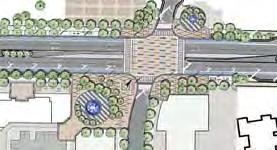
34 Streetscape Master Plan Linked Districts The street design for the South Yonge Street Corridor Streetscape Master Plan will become a place that people will travel to rather than travel through as the implementation of the subway becomes a reality. It combines the functional requirements of street design in an urban setting with the qualitative elements that ensure the street is accessible, becomes a destination both day and night and creates vibrant social spaces that define community focus. The function and nature of Yonge Street will change substantially once the proposed subway is completed. York Region s Transit FIRST philosophy that the automobile is secondary is emphasized here. Districts Structure Plan YONGE - STEELES DISTRICT CN RAIL BRIDGE CLARK STATION DISTRICT OLD THORNHILL DISTRICT DON RIVER BRIDGE THRESHOLD THRESHOLD STEELES AVE. CN RAIL CLARK AVE. CENTRE ST. DON RIVER NEW THORNHILL VILLAGE DISTRICT HIGHWAY 407 / HYDRO LANDS THRESHOLD RICHMOND HILL CENTRE DISTRICT ROYAL ORCHARD BLVD. LANGSTAFF RD. HWY 407/ETR HIGH TECH RD. BANTRY AVE. NORTH South Yonge Street Corridor Streetscape Master Plan: Executive Summary 7


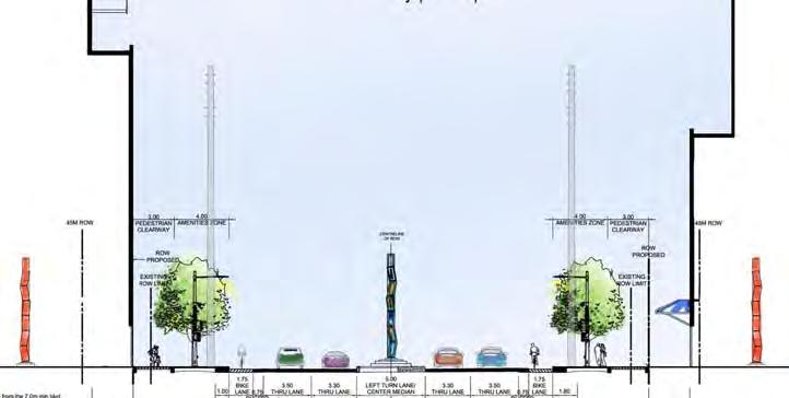
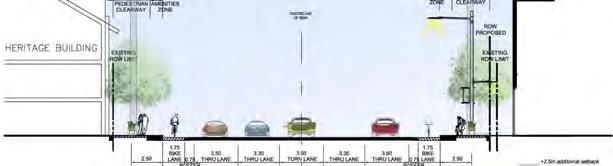
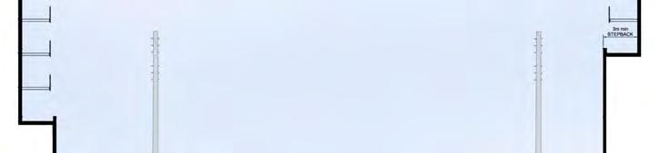
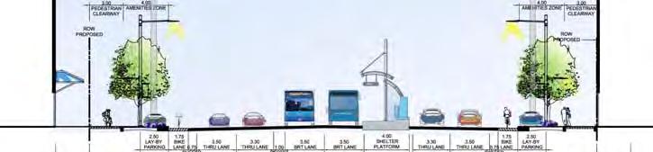
35 Master Plan Elements Unifying Elements Unifying streetscape elements will be located throughout the rightof-way zone along the length of Yonge Street, in both the street design of the roadway and the boulevard. The roadway is primarily the vehicular zone, while the boulevard is generally the pedestrian zone. These elements will provide continuity along the entire length of the streetscape, while providing certain variations within the special character areas. Roadway Travel lanes Bicycle lanes Median / Centre Left Turn Lane Boulevard Continuity Strip Paving Lighting Street Furniture Wayfinding / Signage Boulevard Roadway Boulevard 8 South Yonge Street Corridor Streetscape Master Plan: Executive Summary Character Areas Philosophy Three strategies are required to create distinct identity for the character areas and thresholds along Yonge Street one that builds on existing character in some districts, one that creates appropriate new character in other districts and one that leverages the opportunities inherent in the infrastructure thresholds. Strategy 1 - Protect and Enhance Existing Character Further developing the existing character areas such as the Clark Station district, Old Thornhill and New Thornhill districts to enhance their distinct characters will advance the overall streetscape identity and provide variation and along the corridor. Strategy 2 - Create New Character Developing urban character treatments for places along Yonge Street that are currently slated for major re-development including the Steeles to CN Rail Bridge district, the Longbridge / Langstaff district and the Richmond Hill Centre will also be important to the overall continuity and success of the streetscape plan. Utilizing a range of consistent strategies and techniques for these challenging areas will help to unify Yonge Street throughout the study area. Strategy 3 - Leverage Infrastructure In addition, the ability to leverage the opportunities related to the major infrastructure threshold components represents the other important strategy. The CN Bridge offers the possibility of creating a much needed public space along Yonge Street. The Don River Bridge provides excellent viewing into the natural areas of the valley as well as opportunities for pedestrian access to the valley. The Highway 407/Hydro corridor presents the chance to create a large scale, bold landscape expression.


36 Steeles CN Rail Don River HWY 407 Bantry Yonge Steeles Gateway District Distinctive Urban Character 4 Corner Treatment Vibrant Streetscape and People Friendly Spaces Plan View Perspective Distinct Character Areas Urban Square Tree Planting Paving Palette Median Treatment South Yonge Street Corridor Streetscape Master Plan: Executive Summary 9


37 Distinct Character Areas Steeles CN Rail Don River HWY 407 Bantry CN Rail Bridge Threshold Elevated Platform Park Pedestrian Viewing Finishes and Colour Palette Plan View Sitting Areas Materials Specialty Lighting 10 South Yonge Street Corridor Streetscape Master Plan: Executive Summary


38 Steeles CN Rail Don River HWY 407 Bantry Clark Station District Urban Transit Plaza Plan View Distinct Character Areas Subway Entrance Plaza Street Trees Specialty Lighting Perspective South Yonge Street Corridor Streetscape Master Plan: Executive Summary 11


39 Distinct Character Areas Steeles CN Rail Don River HWY 407 Bantry Old Thornhill Village District Heritage Community Character Streetscape as Integrator Old and New Interpretive Signage Specialty Planting Paving Palette Plan View Perspective 12 South Yonge Street Corridor Streetscape Master Plan: Executive Summary


40 Distinct Character Areas Steeles CN Rail Don River HWY 407 Bantry Don River Bridge Threshold Enhance Natural Valley Features Public Art as Infrastructure Pedestrian Connection and Viewing Specialty Lighting Public Art Elements Planting Plan View Materials Palette Viewing Areas South Yonge Street Corridor Streetscape Master Plan: Executive Summary 13


41 Distinct Character Areas Steeles CN Rail Don River HWY 407 Bantry New Thornhill District Transition from Don River Double Row of Street Trees Mid-block Links Plan View 14 South Yonge Street Corridor Streetscape Master Plan: Executive Summary Specialty Lighting Street Tree Planting Paving Palette


42 Distinct Character Areas Steeles CN Rail Don River HWY 407 Bantry Highway 407 Threshold 407 Hydro Art Park Pedestrian and Open Space Connections Plan View Public Art Planting Walls Planting Specialty Lighting South Yonge Street Corridor Streetscape Master Plan: Executive Summary 15


43 Distinct Character Areas Steeles CN Rail Don River HWY 407 Bantry Richmond Hill Centre District Richmond Hill Centre/ Langstaff UGC Transit Integration Paving Palette Specialty Planting Plan View Perspective 16 South Yonge Street Corridor Streetscape Master Plan: Executive Summary Tree Planting


44 Streetscape Conditions Steeles CN Rail Don River HWY 407 Bantry Yonge Steeles Gateway District A B A B Key Plan - Sections Section A-A The pavement width will respond to the operational Section B-B requirements during the Pre-Subway and Subway phases. The pavement width will respond to the operational requirements during the Pre-Subway and Subway phases. South Yonge Street Corridor Streetscape Master Plan: Executive Summary 17


45 Streetscape Conditions Steeles CN Rail Don River HWY 407 Bantry Old Thornhill Village District Key Plan - Sections Section C-C The pavement width will respond to the operational requirements during the Pre-Subway and Subway phases. 18 South Yonge Street Corridor Streetscape Master Plan: Executive Summary C D C D Key Plan - Sections Section D-D The pavement width will respond to the operational requirements during the Pre-Subway and Subway phases.


46 New Thornhill District Streetscape Conditions Steeles CN Rail Don River HWY 407 Bantry Section E-E The pavement width will respond to the operational requirements during the Pre-Subway and Subway phases. E E Key Plan - Sections South Yonge Street Corridor Streetscape Master Plan: Executive Summary 19


47 Streetscape Conditions Steeles CN Rail Don River HWY 407 Bantry Richmond Hill Centre District Key Plan - Sections Section F-F The pavement width will respond to the operational requirements during the Pre-Subway and Subway phases. 20 South Yonge Street Corridor Streetscape Master Plan: Executive Summary Section G-G F F The pavement width will respond to the operational requirements during the Pre-Subway and Subway phases. G G
48 The Phasing Plan was prepared in response to the reality that no final decision on the timing and funding of the subway is imminent. In the absence of a decision and accompanying funding for the subway, Yonge Street must continue to function as a major commuter route accommodating increasing traffic flow and functions for the foreseeable future. The prime assumption upon which the Pre-Subway Plan is built is that it will continue to use existing roadway infrastructure including pavement width and curb lines. The Plan identifies areas of boulevard where implementation of the Streetscape Master Plan could potentially take place without compromising the roadway and traffic functions or that would require reconstruction when the subway is built. The Pre-Subway Plan represents the early wins in building the Streetscape Master Plan. Phasing Plan Condition A: Open-cut areas that cannot be developed until subway construction is complete (Ultimate Plan). Condition B: Areas where the Master Plan can be slightly modified using existing curbs (Pre-Subway Plan). Condition C: Areas where roadway widths are narrower than the proposed design and can be expanded with no loss of transportation function (Pre-Subway Plan). Condition D: Areas where the current roadway is wider by 1.5 to 2.5 metres than the proposed allocation and it would be preferable to wait until the road is narrowed to achieve a more spacious pedestrian zone (Ultimate Plan). South Yonge Street Corridor Streetscape Master Plan: Executive Summary 21
49 Capital Costs The estimate of probable capital cost of construction of the Streetscape Master Plan is based on the Ultimate and Pre-Subway plans for the anticipated streetscape works illustrated in the Master Plan. These preliminary estimates are qualified based on several factors: Design the master plan conceptual drawings and sketches illustrate key dimensions and materials, but not all specific conditions throughout the study area; Technical the master plan represents a new design that explores innovative technologies relative to components such as planting, paving, drainage and other features; Cost unit costs are taken from specific experience with other similar projects in York Region (2011 dollars). Together, these factors provide an overall level of accuracy of approximately ±20%. Based on this, the anticipated costs for the Streetscape Master Plan includes a 20% contingency. Proposed Standards for Yonge Street The proposed standards for Yonge Street are based on the Streetscape Master Plan for South Yonge Street predicated on the construction of the Yonge Street subway from Finch to Richmond Hill Centre. As the Main Street for York Region, the Streetscape Master Plan for South Yonge Street envisions a modern, vibrant, multi-functional urban streetscape flanked by a variety of land uses including medium to high density residential, at-grade retail and commercial uses, as well as the protection and enlargement of existing heritage areas. The proposed streetscape standards and associated capital costs for Yonge Street reflect this character. 22 South Yonge Street Corridor Streetscape Master Plan: Executive Summary Existing Capital Costs Three existing standards and associated costs within York Region have been reviewed. These include streetscapes without medians, streetscapes with medians, and enhanced streetscapes, such as those included in the vivanext projects. Capital Costs Existing Streetscape Policy (per km) The costs are based on 2011 Urban Cross Section from Transportation Services, Roads Capital Delivery. The total cost for streetscape including street trees, sidewalks, and a median totals approximately $4.5 million/km. This figure excludes the cost of utilities. Capital Costs Enhanced Streetscapes (per km) Enhanced streetscape costs within the Region (i.e. vivanext projects) amount to approximately $ million/km. These enhanced streetscape costs include substantial upgrades from the other existing standards in terms of quality of materials and design. Cost Estimate The order of magnitude cost estimate for the full build-out of the Streetscape Subway Plan (Ultimate) is approximately $45,000,000 (+ HST) excluding underground power distribution and other utilities, and public art. This amounts to an average cost of $8.0 million per kilometre. The order of magnitude cost estimate for the Streetscape Pre-Subway Plan is approximately $38,000,000 (+ HST), excluding underground power distribution and other utilities and public art. This amounts to an average cost of $6.78 million per kilometre.
50 Maintenance + Operating Costs The maintenance and operational costs for the streetscape are based on the itemization of considerations and components as outlined below that are required to ensure the proper care required for the longevity and attractiveness of the initial investment. Recommended Maintenance + Operating Costs The maintenance and operational costs for South Yonge Street are detailed in the South Yonge Street Phase 5 Report. The costs presented are based on the VivaNext H3 Project through which cost assumptions are presented for enhanced streetscapes within York Region. Local municipal input into the projected maintenance costs are also accounted for in the figures. It is estimated that maintenance costs per annum will be in the range of $300,000-$350,000 / km depending on the character area and streetscape elements. Key Assumptions Hardscape Concrete Sidewalk (3m wide each side). Pavers on concrete base. Streetprint - Cleaning and repair costs assume washing / colouring once a year, more sweeping, repainting every 15 years. Median without planting (excluding public art). Crosswalks (all 4 arms) - Repainting every 15 years. Softscape Tree - Pruning, watering, mulching / fertilizing, infiltration / irrigation system maintenance / flushing. Planters - Watering / plant maintenance in addition to tree care. Ground cover Planting - Trash removal and minor plant maintenance needs. Site Furnishings and Lighting Bike Racks Graffiti removal. Trash Cans - Graffiti removal. Benches - Graffiti removal. Road and Pedestrian Lighting maintenance. LED fixtures Graffiti abatement, ongoing operation / repair. South Yonge Street Corridor Streetscape Master Plan: Executive Summary 23

51 Funding Options Bloor- Yorkville BIA Streetscape Revitalization funded in partnership with City of Toronto 24 South Yonge Street Corridor Streetscape Master Plan: Executive Summary Potential Funding Sources include... Development Charge Funds Section 37 Benefits Business Improvement Area (BIA) Funding York Region Municipal Streetscape Partnership Program VivaNext Other Funding Partners While not directly applicable to the usual funding sources for streetscape there may be other non-conventional sources and / or partnerships with stakeholders that should be investigated, including: - Highway 407 ETR - CN Rail - Hydro One - Private Donors / Sponsors for public art - Environmental Partnerships (e.g. TRCA, etc.)
52 Leadership and Support for Implementing the Streetscape Master Plan York Region to lead the implementation of the Streetscape Master Plan in collaboration with local municipalities and the private sector to achieve commitment towards creating a world class street. Support for local policies that integrate the South Yonge Street Corridor Streetscape Master Plan and speak to the importance of this primary urban corridor. Continued communications with major stakeholders such as York Region Rapid Transit Company, Powerstream, MTO / 407 ETR, CN Rail, and City of Toronto. Major Focus on Funding the Streetscape Master Plan Leverage existing funding opportunities for streetscape design through the development process. Explore alternative funding sources for implementation to complement existing sources. Establish Business Improvement Areas (BIAs) for Vaughan, Markham, and Richmond Hill business owners. Explore harmonization of operations/maintenance practices in partnership with local municipalities. Key Recommendations Establish Implementation Teams that support and facilitate the Streetscape Master Plan Establish a Streetscape Implementation Team that will focus on the planning, monitoring, evaluating, and achieving efficiencies between local and Region operations/maintenance. The team will also be tasked to facilitate the development process along this corridor. Establish a Public Utilities Coordination Committee dedicated to South Yonge Street in planning and coordinating utilities within right-of-way in support of the streetscape master plan. A major objective of this committee may be to develop implementation options in integrating utilities seamlessly into an urban context. Establish Public Art Steering Committee that is dedicated to outlining opportunities for siting public art on public / private property, and the review of public art proposals based on a Shared Public Art Policy for South Yonge Street. South Yonge Street Corridor Streetscape Master Plan: Executive Summary 25

53 COUNCIL ATTACHMENT 2

54 Page 1 of 2 COUNCIL ATTACHMENT 3

55 Page 2 of 2
South Yonge Street Corridor
 South Yonge Street Corridor Streetscape Master Plan Study Draft Final Executive Summary Prepared by: January 2012 In Partnership with: Introduction The Future... Yonge Street is at the forefront of York
South Yonge Street Corridor
 South Yonge Street Corridor Streetscape Master Plan Study Draft Final Report Phase 3: Streetscape Master Plan and Pre-Subway Plan May 2011 Prepared by: In Partnership with: South Yonge Street Corridor
South Yonge Street Corridor
 South Yonge Street Corridor Streetscape Master Plan Study Draft Report Phase 5: Implementation Strategy June 2011 Prepared by: In Partnership with: South Yonge Street Corridor Streetscape Master Plan
13 THORNHILL YONGE STREET STUDY IMPLEMENTATION CITY OF VAUGHAN OPA 669 AND TOWN OF MARKHAM OPA 154
 13 THORNHILL YONGE STREET STUDY IMPLEMENTATION CITY OF VAUGHAN OPA 669 AND TOWN OF MARKHAM OPA 154 The Planning and Economic Development Committee recommends the adoption of the recommendations contained
3 MARKHAM NORTH-SOUTH LINK CORRIDOR PUBLIC TRANSIT IMPROVEMENTS ENVIRONMENTAL ASSESSMENT UPDATE
 3 MARKHAM NORTH-SOUTH LINK CORRIDOR PUBLIC TRANSIT IMPROVEMENTS ENVIRONMENTAL ASSESSMENT UPDATE The Rapid Transit Public/Private Partnership Steering Committee recommends the adoption of the recommendations
YONGE STEELES CORRIDOR SECONDARY PLAN. Young + Wright / IBI Group Architects Dillon Consulting Ltd. GHK International (Canada) Ltd.
 Ltd.") PART A: PREAMBLE 1.0 PURPOSE The purpose of this Secondary Plan is to provide a development framework for intensification of the Yonge/ Steeles corridor including the north side of Steeles Avenue West
PART A: PREAMBLE 1.0 PURPOSE The purpose of this Secondary Plan is to provide a development framework for intensification of the Yonge/ Steeles corridor including the north side of Steeles Avenue West
SCARBOROUGH SUBWAY EXTENSION. Scarborough Subway Extension. Final Terms of Reference
 Scarborough Subway Extension Final Terms of Reference 1 1.0 Introduction and Background 1.1 Introduction Toronto City Council recently confirmed support for an extension of the Bloor-Danforth Subway from
CITY OF VAUGHAN EXTRACT FROM COUNCIL MEETING MINUTES OF NOVEMBER 15, 2016
 Item 11, Report No. 38, of the Committee of the Whole, which was adopted without amendment by the Council of the City of Vaughan on November 15, 2016. Regional Councillor Di Biase declared an interest
~!VAUGHAN NOV Z November 21, Mr. Denis Kelly, Regional Clerk The Regional Municipality of York Yonge Street Newmarket, ON L3Y 6Z1
 ~!VAUGHAN NOV Z 5 2016 November 21, 2016 Mr. Denis Kelly, Regional Clerk The Regional Municipality of York 17250 Yonge Street Newmarket, ON L3Y 6Z1 Dear Mr. Kelly: RE: NEW KIRBY GO STATION IN BLOCK 27
9 CITY OF VAUGHAN OFFICIAL PLAN AMENDMENT NO BOCA EAST INVESTMENTS LIMITED
 9 CITY OF VAUGHAN OFFICIAL PLAN AMENDMENT NO. 631 - BOCA EAST INVESTMENTS LIMITED The Planning and Economic Development Committee recommends the adoption of the recommendations contained in the following
Town of Oakville Streetscape Strategy
 Town of Oakville Streetscape Strategy Endorsed by PDC on February 10, 2014 (PD-011-14) Town of Oakville Streetscape Strategy [endorsed by PDC February 10, 2014] 0 Town of Oakville Streetscape Strategy
CONTENTS 2.0 A FRAMEWORK FOR SUSTAINABLE GROWTH 2.1 MANAGING SUSTAINABLE GROWTH THE VISION TO GOALS AND OBJECTIVES 2.3 MARKHAM STRUCTURE
 2 A Framework for Sustainable Growth 2.0 A FRAMEWORK FOR SUSTAINABLE GROWTH CONTENTS 2.1 MANAGING SUSTAINABLE GROWTH THE VISION TO 2031 2.2 GOALS AND OBJECTIVES 2.2.1 Protecting the Natural Environment
2.0 A FRAMEWORK FOR SUSTAINABLE GROWTH CONTENTS
 2-2 A Framework for Sustainable Growth 2.0 A FRAMEWORK FOR SUSTAINABLE GROWTH CONTENTS 2.1 MANAGING SUSTAINABLE GROWTH THE VISION TO 2031 2.2 GOALS AND OBJECTIVES 2.2.1 Protecting the Natural Environment
2 STATUTORY PUBLIC MEETING AND INFORMATION REPORT FOR PUBLIC MEETING ON AMENDMENT NO. 62 TO THE YORK REGION OFFICIAL PLAN
 2 STATUTORY PUBLIC MEETING AND INFORMATION REPORT FOR PUBLIC MEETING ON AMENDMENT NO. 62 TO THE YORK REGION OFFICIAL PLAN Pursuant to Section 17(15) of the Planning Act, as amended, the Regional Planning
John M. Fleming Managing Director, Planning and City Planner. Old East Village Dundas Street Corridor Secondary Plan Draft Terms of Reference
 Report to Planning and Environment Committee To: From: Subject: Chair and Members Planning & Environment Committee John M. Fleming Managing Director, Planning and City Planner Old East Village Dundas Street
CITY CLERK. Parkland Acquisition Strategic Directions Report (All Wards)
") CITY CLERK Clause embodied in Report No. 10 of the, as adopted by the Council of the City of Toronto at its meeting held on November 6, 7 and 8, 2001. 10 Parkland Acquisition Strategic Directions Report
CITY CLERK Clause embodied in Report No. 10 of the, as adopted by the Council of the City of Toronto at its meeting held on November 6, 7 and 8, 2001. 10 Parkland Acquisition Strategic Directions Report
Scope of Services. River Oaks Boulevard (SH 183) Corridor Master Plan
 Corridor Master Plan") Scope of Services River Oaks Boulevard (SH 183) Corridor Master Plan PROJECT AREA The project area consists of the River Oaks Boulevard (SH 183) corridor bounded by SH 199 at the northern end and the Trinity
Scope of Services River Oaks Boulevard (SH 183) Corridor Master Plan PROJECT AREA The project area consists of the River Oaks Boulevard (SH 183) corridor bounded by SH 199 at the northern end and the Trinity
WITNESS STATEMENT Of. Ronald Blake. On behalf of the Intervenor The Corporation of the City of Markham
 Filed: 2013-06028 EB-2012-0451 Exhibit L.EGD.COM.2 Page 1 of 7 WITNESS STATEMENT Of Ronald Blake On behalf of the Intervenor The Corporation of the City of Markham In the matter of an application by Enbridge
Report to: Development Services Committee Report Date: April 24, 2017
 SUBJECT: Cornell Rouge National Urban Park Gateway - Report on Design Charrette and Next Steps PREPARED BY: Lilli Duoba, MES, MCIP, RPP, Manager, Natural Heritage (ext. 7925) REVIEWED BY: Marg Wouters,
38 Queen s University Campus Master Plan Part 1
 38 Queen s University Campus Master Plan Part 1 46 The Campus at the City Scale Chapter 4 The Campus at the City Scale 39 Queen s is an urban University centrally located in Kingston. Decisions made by
CITY OF VAUGHAN EXTRACT FROM COUNCIL MEETING MINUTES OF JUNE 7, 2016
 Item 5, Report No. 26, of the Committee of the Whole (Working Session), which was adopted without amendment by the Council of the City of Vaughan on June 7, 2016. 5 MUNICIPAL CLASS ENVIRONMENTAL ASSESSMENT
THAT the attached Terms of Reference for the Thornhill Centre Street Study be approved.
 COMMITTEE OF THE WHOLE AUGUST 18, 2003 THORNHILL CENTRE STREET STUDY PLANNING FILE: 15.92 Recommendation The Commissioner of Planning recommends: THAT the attached Terms of Reference for the Thornhill
Welcome. Walk Around. Talk to Us. Write Down Your Comments
 Welcome This is an information meeting introducing the applications for proposed redevelopment of the Yorkdale Shopping Centre site at 3401 Dufferin Street and 1 Yorkdale Road over the next 20+ years,
CITY OF VAUGHAN D R A F T YONGE STREET STUDY. June 2008 YOUNG + WRIGHT /IBI GROUP ARCHITECTS DILLON CONSULTING LTD.
 CITY OF VAUGHAN June 2008 YOUNG + WRIGHT /IBI GROUP ARCHITECTS GHK SUSTAINABILITY INTERNATIONAL + LIVABILITY (CANADA) LTD. = COMMUNITY VALUE DILLON CONSULTING LTD. Public Open House Tonight s Meeting WELCOME
Urban Design Manual PLANNING AROUND RAPID TRANSIT STATIONS (PARTS) Introduction. Station Study Areas
 Introduction. Station Study Areas") 111111 PLANNING AROUND RAPID TRANSIT STATIONS (PARTS) Introduction The ION rapid transit system will link Waterloo, Kitchener and Cambridge through a central transit corridor (CTC). There are a number
111111 PLANNING AROUND RAPID TRANSIT STATIONS (PARTS) Introduction The ION rapid transit system will link Waterloo, Kitchener and Cambridge through a central transit corridor (CTC). There are a number
2.0 A FRAMEWORK FOR SUSTAINABLE GROWTH CONTENTS
 2-2 A Framework for Sustainable Growth 2.0 A FRAMEWORK FOR SUSTAINABLE GROWTH CONTENTS 2.1 MANAGING SUSTAINABLE GROWTH THE VISION TO 2031 2.2 GOALS AND OBJECTIVES 2.2.1 Protecting the Natural Environment
WELCOME TO OPEN HOUSE # 3
 Bayview Avenue Class Environmental Assessment Study Steeles Avenue to Elgin Mills Road WELCOME TO OPEN HOUSE # 3 Please sign in and join our mailing list Why Are We Here Tonight? Study Process and Purpose
1.0 Purpose of a Secondary Plan for the Masonville Transit Village
 Report to Planning and Environment Committee To: Chair and Members Planning & Environment Committee From: John M. Fleming Managing Director, Planning and City Planner Subject: Masonville Transit Village
PART 1. Background to the Study. Avenue Study. The Danforth
 The Danforth 1.1/ Study Purpose & Key Municipal Goals 1.2/ The Local Advisory Committee 1.3/ The Project Team 1.4/ Study Process/Summary of Method 1.5/ Summary of Consultation 1.1 Study Purpose and Key
Emery Village Road 2A Municipal Class Environmental Assessment Study
 PW12.11 STAFF REPORT ACTION REQUIRED Emery Village Road 2A Municipal Class Environmental Assessment Study Date: March 30, 2016 To: From: Wards: Reference Number: Public Works and Infrastructure Committee
5 TOWN OF MARKHAM OFFICIAL PLAN AMENDMENT NO. 144 MILLIKEN MAIN STREET SECONDARY PLAN
 5 TOWN OF MARKHAM OFFICIAL PLAN AMENDMENT NO. 144 MILLIKEN MAIN STREET SECONDARY PLAN The Planning and Economic Development Committee recommends the following: 1. The communication from Brendan O Callaghan,
Town Center (part of the Comprehensive Plan)
") Town Center (part of the Comprehensive Plan) Mercer Island Town Center Looking North (2014) In 1994, a year-long process culminated in a set of design guidelines and code requirements for the Town Center
Town Center (part of the Comprehensive Plan) Mercer Island Town Center Looking North (2014) In 1994, a year-long process culminated in a set of design guidelines and code requirements for the Town Center
Local Growth Planning in North Central Green Line Communities
 2018 April 30 Page 1 of 6 EXECUTIVE SUMMARY This report outlines a high-level scope for local growth planning for north central Green Line communities. The catalyst for this review is the significant investments
12 AMENDMENT NO. 149, TOWN OF MARKHAM HIGHWAY 404 NORTH SECONDARY PLAN
 12 AMENDMENT NO. 149, TOWN OF MARKHAM HIGHWAY 404 NORTH SECONDARY PLAN The Planning and Economic Development Committee recommends the adoption of the recommendation contained in the following report August
Official Plan Review: Draft Built Form Policies
 PG.30.1 REPORT FOR ACTION Official Plan Review: Draft Built Form Policies Date: May 15, 2018 To: Planning and Growth Management Committee From: Chief Planner and Executive Director, City Planning Division
THE CITY OF VAUGHAN BY-LAW BY-LAW NUMBER A By-law to adopt Amendment Number 1 to the Official Plan of the Vaughan Planning Area.
 THE CITY OF VAUGHAN BY-LAW BY-LAW NUMBER 015-2014 A By-law to adopt Amendment Number 1 to the Official Plan of the Vaughan Planning Area. NOW THEREFORE the Council of the Corporation of the City of Vaughan
Streets for People, Place-Making and Prosperity. #TOcompletestreets
 COMPLETE STREETS FOR TORONTO Streets for People, Place-Making and Prosperity COMPLETE STREETS: A NEW APPROACH A Complete Streets design approach considers the needs of all users people who walk, bicycle,
6 Growth Management Challenges and Opportunities
 6 Growth Management Challenges and Opportunities The Town has established a goal of attaining a 50% participation rate with respect to employment opportunities versus residential population. The Town s
City of Toronto. Emery Village Transportation Master Plan
 City of Toronto Emery Village Transportation Master Plan May 2009 Emery Village Transportation Master Plan Toronto, ON May 2009 Consulting Inc. 100 York Blvd., Suite 300 Richmond Hill, ON L4B 1J8 Tel:
The Corporation of the Town of Milton
 Report To: From: Council Barbara Koopmans, Commissioner, Planning and Development Date: May 7, 2018 Report No: Subject: Making it Possible Positioning the Town s Strategy for Growth and Economic Development
Clairtrell Area Context Plan
 Clairtrell Area Context Plan March 2005 Urban Development Services City Planning Contents 1. Introduction... 4 2. Development Structure... 6 2.1 Streets... 7 2.1.1 Sheppard Avenue and Bayview Avenue...
The West Vaughan Employment Area Secondary Plan Policies
 Part 2: The West Vaughan Employment Area Secondary Plan Policies 2.1 General Policies It is the policy of Council: 2.1.1. That the West Vaughan Employment Area (the WVEA), identified on Schedule 1, will
The Commissioner of Engineering and Public Works recommends that this report be received for information purposes.
 COMMITTEE OF THE WHOLE FEBRUARY 1, 2011 407 TRANSITWAY - ENVIRONMENTAL PROJECT REPORT MINISTRY OF TRANSPORTATION CITY WIDE Recommendation The Commissioner of Engineering and Public Works recommends that
ARLINGTON COUNTY, VIRGINIA
 ARLINGTON COUNTY, VIRGINIA County Board Agenda Item Meeting October 15, 2005 DATE: September 28, 2005 SUBJECT: Request to Advertise the adoption of the 2005 Clarendon Sector Plan C. M. RECOMMENDATION:
Don Mills Crossing Study and Celestica Lands Development Application Community Meeting, Open House, and Breakout Discussions
 Consultation Summary Don Mills Crossing Study and Celestica Lands Development Application Community Meeting, Open House, and Breakout Discussions This report is not intended to provide a verbatim transcript
Mark-up of the effect of the proposed Bronte Village Growth Area OPA No.18 on the text of section 24, Bronte Village, of the Livable Oakville Plan
 Mark-up of the effect of the proposed Bronte Village Growth Area OPA No.18 on the text of section 24, Bronte Village, of the Livable Oakville Plan Notes: This document is provided for information purposes
CITY COUNCIL AGENDA REPORT
 CITY COUNCIL AGENDA REPORT Subject: COUNCIL MOTION LRT ALIGNMENT REMOVAL FROM THE TRANSPORTATION MASTER PLAN On February 10, 2016 Councillor Hughes provided notice in accordance with Section 23 of Procedure
Portage Parkway Environmental Assessment Public Information Centre No. 1
 City of Vaughan Portage Parkway Environmental Assessment Public Information Centre No. 1 November 25, 2015 Welcome to the Public Information Centre This first Public Information Centre (PIC) introduces
New-Cast Mixed-use Development Proposal King Street West, Newcastle, Ontario
 URBAN DESIGN BRIEF New-Cast Mixed-use Development Proposal King Street West, Newcastle, Ontario TABLE OF CONTENTS: 1.0 Executive Summary 2.0 Creating Vibrant and Sustainable Urban Places: Excerpts from
COUNCIL ATTACHMENT 2 HIGHWAY 7 CORRIDOR AND VAUGHAN NORTH-SOUTH LINK
 COUNCIL ATTACHMENT 2 HIGHWAY 7 CORRIDOR AND VAUGHAN NORTH-SOUTH LINK Welcome! The purpose today is to: Present the Study Background; Describe Alignment Alternatives Analyzed; Present the Evaluation of
Executive Summary. NY 7 / NY 2 Corridor
 Executive Summary NY 7 / NY 2 Corridor Transportation and Land Use Study December 2005 Prepared for: Town of Colonie Capital District Transportation Committee Prepared by: Introduction: Land use decisions
1.0 PLANNING MARKHAM S FUTURE CONTENTS
 1-1 Planning Markham s Future 1.0 PLANNING MARKHAM S FUTURE CONTENTS 1.1 THE PURPOSE OF THE OFFICIAL PLAN 1.2 THE MARKHAM CONTEXT 1.3 THE REGULATORY CONTEXT 1.3.1 Province of Ontario 1.3.2 York Region
SUBJECT: Waterfront Hotel Planning Study Update TO: Planning and Development Committee FROM: Department of City Building. Recommendation: Purpose:
 Page 1 of Report PB-23-18 SUBJECT: Waterfront Hotel Planning Study Update TO: Planning and Development Committee FROM: Department of City Building Report Number: PB-23-18 Wards Affected: 2 File Numbers:
THE GARDEN CITY PLAN. City of St. Catharines Official Plan. City of St. Catharines
 THE GARDEN CITY PLAN City of St. Catharines Official Plan City of St. Catharines August 2010 APPROVAL INFORMATION This Official Plan of the City of St. Catharines Planning Area, known as the Garden City
PUBLIC OPEN HOUSE HURONTARIO-MAIN CORRIDOR SECONDARY PLAN
 PUBLIC OPEN HOUSE HURONTARIO-MAIN CORRIDOR SECONDARY PLAN Tuesday, February 28, 2012 6pm 9pm 1 st Floor Atrium, City Hall 2 Wellington Street West, Brampton 1 POLICY FRAMEWORK The 2006 Provincial Growth
Corridor Vision. 1Pursue Minnehaha-Hiawatha Community Works Project. Mission of Hennepin County Community Works Program
 1Pursue Minnehaha-Hiawatha Community Works Project Minnehaha-Hiawatha Community Works is a project within the Hennepin Community Works (HCW) program. The mission of the HCW program is to enhance how the
Town of Cobourg Heritage Master Plan. Statutory Public Meeting
 Town of Cobourg Heritage Master Plan Statutory Public Meeting April 25 th 2016 Presentation Overview 1. Introduction 2. Project background and schedule overview 3. Review of strategic direction content
Integration of Trees into Roads Policy - the road to success -
 Integration of Trees into Roads Policy - the road to success - Trees, People and the Built Environment 3 City of Birmingham, UK April 5 th, 2017 Ian Buchanan Natural Heritage and Forestry Regional Municipality
Implementation Guide Comprehensive Plan City of Allen
 Implementation Guide 2030 Comprehensive Plan City of Allen DRAFT 2015 Implementation Guide Allen 2030 Comprehensive Plan INTRODUCTION The Comprehensive Plan serves as a guide for the growth and development
Downtown Whitby Action Plan
 Downtown Whitby Action Plan Final Report October 2016 Table of Contents Introduction 1 Public Consultation 2 Walkability 3 Downtown Whitby Walkability Map 4 Vision 5 Goal & Objectives 6 Objective 1 7 Objective
Report to: Development Services Committee Report Date: September 11, 2017
 ~RKHAM Report to: Development Services Committee Report Date: September 11, 2017 SUBJECT: PREPARED BY: Conceptual Master Plan for the Future Urban Area - Community Structure Plan and Key Policy Direction
Urban Planning and Land Use
 Urban Planning and Land Use 701 North 7 th Street, Room 423 Phone: (913) 573-5750 Kansas City, Kansas 66101 Fax: (913) 573-5796 Email: planninginfo@wycokck.org www.wycokck.org/planning To: From: City Planning
Hurontario/Main Street Corridor Master Plan Mississauga and Brampton Building a new and integrated vision for the corridor
 Hurontario/Main Street Corridor Master Plan Mississauga and Brampton Building a new and integrated vision for the corridor Martin Powell, Commissioner of Transportation and Works, City of Mississauga Paper
NEW REGIONAL OFFICIAL PLAN HIGH LEVEL PROCESS & FRAMEWORK
 NEW REGIONAL OFFICIAL PLAN HIGH LEVEL PROCESS & FRAMEWORK Why A New Official Plan Originally the role of Regionally Planning and content of Regional Official Plan (1970s) primarily focused on protecting
CHAPTER 5: GUIDING PRINCIPLES
 CHAPTER 5: GUIDING PRINCIPLES The following 10 principles were developed based on public consultation, planning policy and the background analysis conducted during Phase 1. The Guiding Principles significantly
Animating the Rideau Canal December 2013
 Executive Summary Animating the Rideau Canal December 2013 Why study the Rideau Canal? The Rideau Canal has been an important part of Ottawa throughout its history, and has shaped and been shaped by the
1 Introduction. Chapter. In this chapter:
 Chapter 1 Introduction In this chapter: 1.1 A Snapshot of the Region 1.2 Towards a Sustainable Region 1.3 The Provincial Context 1.4 Purpose and Organization The Regional Municipality of York Official
3. Endorse the LRT vision in transforming Surrey into Connected-Complete-Livable communities, and more specifically, the official vision statement:
 CORPORATE REPORT NO: R038 COUNCIL DATE: February 20, 2017 REGULAR COUNCIL TO: Mayor & Council DATE: February 16, 2017 FROM: General Manager, Engineering FILE: 8740-01 SUBJECT: Surrey Light Rail Transit
Lambeth Main Street Streetscape Improvements
 Lambeth Main Street Streetscape Improvements Open House October 5th, 2017 Agenda 1. Introduction 2. Project Background 3. Context 4. Project Objectives 5. Design Principles & Approach 6. Streetscape Design
Report No. 4 of the Planning and Economic Development Committee Regional Council Meeting of April 21, 2011
 Report No. 4 of the Planning and Economic Development Committee Regional Council Meeting of April 21, 2011 3 RICHMOND HILL/LANGSTAFF GATEWAY REGIONAL AND PROVINCIAL URBAN GROWTH CENTRE FRAMEWORK FOR PROPOSED
Mobility Hub Guidelines: Tools for Achieving Successful Station Areas
 Mobility Hub Guidelines: Tools for Achieving Successful Station Areas This paper introduces Metrolinx s recently released Mobility Hub Guidelines and highlights two key aspects of the document: the importance
VILLAGE OF BOLTON HERITAGE CONSERVATION DISTRICT PLAN
 Page 1 1. INTRODUCTION AND BACKGROUND 1.1 THE PROJECT VILLAGE OF BOLTON HERITAGE CONSERVATION DISTRICT PLAN TERMS OF REFERENCE The Town of Caledon (Town) is a large, predominantly rural municipality with
New Official Plan Quest November 2013
 City of Markham New Official Plan Quest November 2013 Building Markham s Future Together - 6 Key Strategic Priorities 1. Growth - Managing our Growth 2. Transportation/Transit - Improving transportation
The transportation system in a community is an
 7 TRANSPORTATION The transportation system in a community is an important factor contributing to the quality of life of the residents. Without a sound transportation system to bring both goods and patrons
Hockessin Community Redevelopment Plan
 Hockessin Community Redevelopment Plan 3.1 Introduction The Community Redevelopment Plan for the Village of Hockessin is the result of the people s vision for a distinct village center that serves as the
WELCOME and introduction
 1 WELCOME and introduction Mobility Hub Locations within Burlington STUDY OVERVIEW STUDY OBJECTIVES The City of Burlington is developing four Area Specific Plans, one for each of Burlington s Mobility
Transit-supportive development and city-building
 Photo: Michael Hiemstra (CC BY 2.0) Transit-supportive development and city-building Brief 3: Tools for building infrastructure and policy conditions Building the policy and infrastructure conditions Municipalities
Toronto Complete Streets Guidelines
 c. DTAH 58 60 3.1 70 3.2 Performance Measurement 71 3.3 Exceptions Chapter 3 describes the five general steps in the street design process. Not all projects follow these steps, as the number of steps and
URBAN DESIGN BRIEF URBAN DESIGN BRIEF 721 FRANKLIN BLVD, CAMBRIDGE August 2018
 URBAN DESIGN BRIEF URBAN DESIGN BRIEF 721 FRANKLIN BLVD, CAMBRIDGE August 2018 DESIGN BRIEF CONTENTS PART A 1.0 INTRODUCTION 2.0 DESCRIPTION & ANALYSIS OF SITE CONTEXT 3.0 DESIGN CONSTRAINTS AND OPPORTUNITIES
3 TOWN OF WHITCHURCH-STOUFFVILLE OFFICIAL PLAN AMENDMENT NOS. 116 & 117
 3 TOWN OF WHITCHURCH-STOUFFVILLE OFFICIAL PLAN AMENDMENT NOS. 116 & 117 The Planning and Economic Development Committee recommends the adoption of the recommendations contained in the following report,
THE TOWN OF WASAGA BEACH
 THE TOWN OF WASAGA BEACH Downtown Development Master Plan Committee of the Whole Presentation January 26 th 2017 Uses within this designation should reflect a dependence on tourism as opposed to the permanent
COMMUNITY SUSTAINABILITY AND ENVIRONMENTAL MASTER PLAN IMPLEMENTATION UPDATE
 Attachment 1 COMMUNITY SUSTAINABILITY AND ENVIRONMENTAL MASTER PLAN IMPLEMENTATION UPDATE Priorities and Key Initiatives Committee May 2013 Page E-1 How we grow Goal 2: To ensure sustainable development
Introduction. Chapter 1. Purpose of the Comprehensive Plan Plan Organization Planning Process & Community Input 1-1
 Chapter 1 Introduction Lakewood 2025: Moving Forward Together Purpose of the Comprehensive Plan Plan Organization Planning Process & Community Input 1-1 Purpose of the Comprehensive Plan The Comprehensive
Route 1 Corridor Study
 Route 1 Corridor Study Westbrook, Connecticut A Vision for the Connecticut Shoreline Public Informational Meeting July 28, 2015 Lower Connecticut River Valley Council of Governments Fitzgerald & Halliday,
Executive Summary. The goals of the Plan are to:
 Executive Summary The Wiscasset Bath Road Master Plan (Plan) seeks to maximize development opportunities along Bath Road through the strategic coordination of traffic infrastructure improvements, land
Public input has been an important part of the plan development process.
 Lakewood s Comprehensive Plan recognizes that transportation helps shape the community, and that the way the community provides for the safe and efficient movement of people affects the character of the
SUBJECT: GO Station Mobility Hubs Preferred Concepts: Aldershot GO, Burlington GO and Appleby GO. Planning and Development Committee - Public Meeting
 Page 1 of Report PB-76-17 SUBJECT: GO Station Mobility Hubs Preferred Concepts: Aldershot GO, Burlington GO and Appleby GO TO: FROM: Planning and Development Committee - Public Meeting Planning and Building
Courtice Main Street Study Community Vision Workshop PLANNING SERVICES DEPARTMENT
 Courtice Main Street Study Community Vision Workshop PLANNING SERVICES DEPARTMENT July 22, 2009 Tonight s Meeting 7:00 pm Introduction David Crome, Director of Planning 7:05 Presentation Stasia Bogdan,
Shift Rapid Transit Public Participation Meeting May 3, 2017
 Shift Rapid Transit Public Participation Meeting May 3, 2017 Shift Rapid Transit Initiative Largest infrastructure project in the city s history. Rapid Transit initiative will transform London s public
Parks Master Plan Implementation: Phase I Waterfront Use and Design REPORT #: September 7, 2016 File #
 0 'O DI Lan-171-14 1 - THE CORPORATION OF THE TOWN OF COBOURG..,. STAFF REPORT TO: FROM: Mayor and Members of Council Dean A. Hustwick, Director of Recreation and Culture DATE OF MEETING: Committee of
COURTICE MAIN STREET COMMUNITY IMPROVEMENT PLAN
 COURTICE MAIN STREET COMMUNITY IMPROVEMENT PLAN Public Meeting #1 April 28, 2016 Birdseye view of the study area PIC #1 AGENDA Agenda and Format 6:30 6:50 Registration 6:50 7:45 Introductions, Presentation
DRAFT PLAN PRESENTATION
 DRAFT PLAN PRESENTATION 1.23.2018 AGENDA Process Project Schedule Results from Visioning Workshop Draft Plan Highlights Concept Plans Feedback Next Steps PROJECT SCHEDULE KICK-OFF WORKSHOP August 29 th
Chapter 1: Introduction
 Chapter 1: Introduction The Penn Avenue Community Works Corridor Vision and Implementation Framework presents an integrated communitybased vision and a coordinated, long-term implementation framework for
ELMVALE ACRES SHOPPING CENTRE MASTER PLAN
 ELMVALE ACRES SHOPPING CENTRE MASTER PLAN Contents 1.0 INTRODUCTION... 2 2.0 LOCATION... 2 3.0 EXISTING CONTEXT... 2 4.0 VISION & GUIDING PRINCIPLES... 2 5.0 LAND USE AND BUILT FORM... 4 5.1 St. Laurent
Toronto Complete Streets Guidelines
 Toronto Complete Streets Guidelines 108 110 7.1 Green Infrastructure Design Principles 112 7.2 Context-Sensitive Green Streets 114 7.3 Key Green Street Elements Green infrastructure refers to natural and
[PLANNING RATIONALE] For Site Plan Control and Lifting of Holding Zone By-Law 101 Champagne Avenue. May 23, 2014
![[PLANNING RATIONALE] For Site Plan Control and Lifting of Holding Zone By-Law 101 Champagne Avenue. May 23, 2014](/thumbs/75/71599615.jpg "[PLANNING RATIONALE] For Site Plan Control and Lifting of Holding Zone By-Law 101 Champagne Avenue. May 23, 2014") [PLANNING RATIONALE] For Site Plan Control and Lifting of Holding Zone By-Law 101 Champagne Avenue May 23, 2014 Contents 1.0 Introduction... 2 2.0 Site Context... 2 2.1 Adjacent Uses... 2 Figure 1: Site
[PLANNING RATIONALE] For Site Plan Control and Lifting of Holding Zone By-Law 101 Champagne Avenue May 23, 2014 Contents 1.0 Introduction... 2 2.0 Site Context... 2 2.1 Adjacent Uses... 2 Figure 1: Site
SECTION E. Realizing the Plan
 SECTION E Realizing the Plan 60 DESIGN REGINA - OFFICIAL COMMUNITY PLAN SECTION E Realizing the Plan Design Regina has been an ambitious plan-making exercise, with a high level of community, stakeholder,
Port Lavaca Future Land Use
 Port Lavaca Future Land Use Introduction The City of Port Lavaca is beginning to see sustained growth, after many years of relative stable population. New single family homes, apartments, and businesses
CONSULTING SERVICES FOR THE WHITEBELT VISIONING EXERCISE ADDENDUM TO THE GTA WEST LAND USE STUDY WORK PROGRAM
 CONSULTING SERVICES FOR THE WHITEBELT VISIONING EXERCISE ADDENDUM TO THE GTA WEST LAND USE STUDY 1. Introduction WORK PROGRAM The Town of Caledon is a large, local municipality located in the Greater Toronto
Eglinton West LRT Update
 Eglinton West LRT Update Community Consultation Update May 16, 2016 Background Rapid transit along Eglinton Ave between Kennedy Station and Pearson Airport was included in the Metrolinx Regional Transportation