Digital Terrestrial Television Infrastructure Rollout. Environmental Impact Assessment - Corridor -
|
|
|
- Moses Stone
- 5 years ago
- Views:
Transcription
1 Digital Terrestrial Television Infrastructure Rollout Environmental Impact Assessment - Corridor -

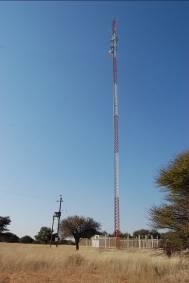
2 1 1 ENVIRONMENTAL IMPACT ASSESSMENT (EIA): CORRIDOR 1.1 INTRODUCTION Corridor is a small farming community approximately 70km from Aminuis and 8km from the eastern border between Namibia and Botswana. 1.2 RATIONALE FOR SITE Due to the remoteness of the village, telecommunication is very important to the residents of the town for obtaining information of planned community activities and news in general. A newly built MTC tower is located 500m north of the DR3816 road. This tower could be used for the proposed NBC infrastructure. The predicted coverage from this position is portrayed in Figure 1. Figure 1: Predicted coverage from the existing infrastructure in Corridor.
 and")
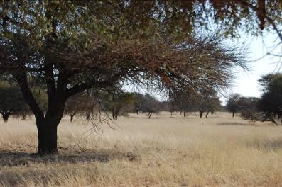
3 2 1.3 SITE DESCRIPTION For this particular site the current position of the broadcasting infrastructure was considered. The existing MTC mast is located far enough from the road to not be visible and is further obscured by the surrounding vegetation which consists of large trees (primarily Acacia species) and grasslands (Figure 2). Even though the site is not expected to be particularly sensitive in terms of birds, some raptors (e.g. Bateleurs, Martial and Tawny eagles) are expected to occur in the proximity of the site. The assessment form below was completed during the site visit based on the visual observations and technical information available at the existing MTC site. Below (in Table 1) follows the completed assessment form for the Corridor site, highlighting information for the investigated alternative: N Figure 2: Position of the existing MTC mast near Corridor in relation to other landmarks.
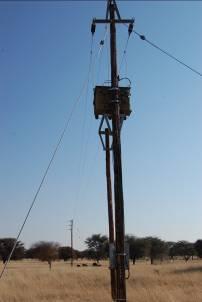
4 3 Table 1: Assessment form for the Corridor site. ACTIVITY INFORMATION 1 Position of the site 2 Footprint of mast 3 Land ownership Latitude Longitude Proposed height of mast Diameter of stay wires Describe how the stay wires will be anchored to the ground (e.g. concrete, rock foundation). To who does the land on which the proposed site is located, belong? (E.g. Private land, state land, town lands, etc.) PROPOSED POSITION (MTC MAST) 23 29'39.30"S 19 53'27.80"E 150m 26mm 48mm Depending on localised geology: cement anchor blocks/rock anchors drilled into bedrock State land 4 Description of General locality, surrounding landscape, Flat, camelthorn savanna the site etc. 5 Project outputs Define any nuisances or negative impacts that could result from the project during Dust, noise, increased traffic on road (associated with the upgrade of infrastructure) the construction and operation (e.g. vibration, noise, radiation, dust). 6 Access to site Existing Road (Yes/No) Yes New Road (Yes/No) Distance of new road Grading of new road (tar or gravel, etc.) Yes, extension needed to the site Approximately 200m To gravel standard Slope where new road will be situated Gradual (gradual, moderate, steep) Best position for new road. Impact will be the same as long as large trees are avoided. 7 Civil Aviation Distance to the nearest airport More than 8km from an airstrip. 8 Waste generation 9 Energy provision Distance to nearest dump site In Aminuis, 70km from the site Distance to nearest power line Power is provided to the site (Figure 3) Required structures (e.g. substations, n/a steel structures) Length of the required power line n/a Is the power line more than 2 km? If yes, then the assessment of the proposed location for the power line should be included in the assessment of the site for the mast. n/a
5 4 SITE DESCRIPTION 1 Landscape Describe the surrounding landscaped, e.g. Ridgeline, plateau, side slope of hill/mountain, closed valley, open valley, plain, undulating plain/low hills. How accessible is the site by vehicle? Flat area Easy access 2 Soil and Geology Unstable rocky slopes/ steep slopes with loose soil Describe soil (e.g. clay, sand, etc.) Identify areas where erosion is likely. n/a Sandy n/a 3 Habitat Natural veld in good condition, natural veld with scattered aliens, natural veld with heavy alien infestation, build-up area, bare soil. A Vegetation Describe the natural vegetation on the site (e.g. dwarf-shrubland). B Birds Is the area likely to be sensitive for birds (i.t.o. Cliffs, Ridges, possible flight paths, trees, water sources)? C Reptiles Is the area likely to be sensitive for reptiles (e.g. rocky outcrops)? D Archaeology Take a picture facing towards the proposed site. E Surface Water Is there any surface water sources located close to the proposed site (e.g. Rivers, Pans, dams, farms dams, oshanas, etc.)? Estimate the distance from the site. Are there any signs of a wetland located close to the proposed site (e.g. mottled soil, grass with plumes, reeds, two-tone vegetation, standing water, birdlife)? Estimate the distance from the site. 4 Visual Consider the aesthetic value of the area (Is it located in a scenic area, what are the lines of sight, are there tourism activities in the area?). Identify possible sensitive receptors (e.g. neighbours, road users, tourism ventures etc.) Natural veld in good condition (Figure 3) Camelthorn savanna (Figure 3) Some sensitive bird species (e.g. Bateleurs, Martial and Tawny eagles) are expected to occur in the area. No None n/a n/a Community-based campsites in the area Road users and tourists
6 5 If a new road will be constructed to the Will be out of sight for the largest group of sensitive site, what will the visual impact be? (E.g. receptors. will it be highly visible or will it be out of sight for the largest group of sensitive receptors). SITE DESCRIPTION Consider the following: * The potential location of a development on landform features within the landscape will influence the visual absorption capacity. For example, structures will be difficult to hide on a ridgeline compared to a deeply incised valley. * Developments on lower slopes will be potentially easier to hide than those on upper slopes. * The visibility of a location of a structure is also influenced by the location height relative to the heights of surrounding topographic features. For example, if a location is lower than the majority of the immediately surrounding landscape it will be less visible and intrusive than a location which is generally higher than the immediate surrounds. * A potential tower location will be easier to hide in a very rugged/diverse landscape and more difficult to do so if the landscape is more homogenous, such as a plain. 5 Social context Describe the surrounding community and land uses (e.g. farm land, town lands, residential area etc.). How far is the nearest inhabited area from the centre point of the mast? (I.t.o. the radiation). Give a short description of the populated area. What type of settlement is it? Site is obscured by the surrounding vegetation. Not visible from the road. Higher trees obscure the visibility of the site. Landscape is diverse North open land, East open land, South open land, West open land 1 km from various small settlements including Corridor.


7 6 Figure 3: Landscapes, vegetation and infrastructure of the associated with the existing position of the broadcasting infrastructure for Corridor
8 7 1.4 PUBLIC PARTICIPATION No on site public participation was done during the site visit. Communication with key stakeholders after the site visit also presented some problems due to the lack of communication services such as or fax. The only stakeholder consulted during the process was the Omaheke Region Council. Their capacity and the comments received are contained in Table 2 below: The aim is to repeat the consultation process just before commencing with the construction phase. Table 2: Capacity of and comments received from the consulted members of the public in Corridor. NAME AFFILIATION POSITION MANNER CONTACTED: CONTACT DETAILS COMMENTS Hon. E.G. Omaheke Region Councillor: Fax (063) Uanguta Council Aminuis or ASSESSMENT OF IMPACTS IDENTIFICATION OF IMPACTS ASSOCIATED WITH THE PROPOSED SITE In order to determine whether the proposed site would require a full environmental assessment with specialist input or whether the available information is sufficient to draw conclusions regarding the true sensitivity of the site, a screening process is applied to the potential impacts of the project (Figure 4).
9 8 Do we have sufficient information to address the issue? YES NO Can issue be addressed through the implementation of a generic EMP? Specialist input required Full EIA YES NO Issues addressed in Generic EMP An Additional Appendix is required to the Generic EMP that contains site specific mitigations. Figure 4: Questions used to screen the potential impacts associated with the development. The Corridor site follows the indicated orange route which implies that most issues can be addressed through a Generic EMP, but that an additional appendix is required to address some site specific issues. Impacts that can sufficiently be addressed through the implementation of a Generic EMP are indicated. Key issues (those impacts that do not necessarily require specialist inputs but requires detailed attention), on the other hand, are indicated and specific management measures are prescribed in an Additional Appendix (Site Specific EMP). Table 3 below indicates how the screening process was applied to the identified impacts at the proposed Corridor site: Table 3: Assessment of potential impacts associated with the proposed site in Corridor. ENVIRONMENTAL FEATURE DESCRIPTION KEY IMPACT ASSOCIATED WITH FEATURE DEGREE OF SENSITIVITY ISSUE ADDRESSED IN: Climate Extreme temperatures Health and safety Low sensitivity Generic EMP associated with the of workforce Kalahari could impact negatively on the
10 9 ENVIRONMENTAL FEATURE DESCRIPTION KEY IMPACT ASSOCIATED WITH FEATURE DEGREE OF SENSITIVITY ISSUE ADDRESSED IN: health and safety of the workforce. Wind direction Dust generated during construction could impact negatively on people living in the proximity of the site. Vegetation Some plant species such as camelthorn trees were observed on site. Reptile/ Small Occurrence of these mammals species on the site. Bird species Occurrence of these species on the site. Occurrence of these species on the site. Socio-Economic Change in available environment visual resources. Civic aviation Disturbance of archaeological landscape Control of construction personnel on construction site Impact on health of residents due to radiation Dust generation during construction. Low sensitivity Generic EMP Loss of protected/ Low sensitivity Generic EMP sensitive plant species. Disturbance to Low sensitivity Generic EMP nests and habitats Loss of biodiversity Medium Site specific EMP sensitivity Bird collisions to Medium Site specific EMP guy ropes of sensitivity mast. Visual impact Low sensitivity Generic EMP More than 8km Low sensitivity Generic EMP from an airstrip Heritage impact Low sensitivity Generic EMP Unsupervised movement of construction workers on site. Damage to private property of farm owner. Low sensitivity Generic EMP Radiation impact Medium Site specific EMP sensitivity Other impacts associated with the construction and operation of the mast Waste management during the construction and operation phases Littering Impact on existing infrastructure Low sensitivity Generic EMP
11 Implication Description 10 ENVIRONMENTAL FEATURE DESCRIPTION KEY IMPACT ASSOCIATED WITH FEATURE DEGREE OF SENSITIVITY ISSUE ADDRESSED IN: Additional strain on Impact on Low sensitivity Generic EMP resources in Corridor infrastructure, due to the occurrence including water, of construction workers. electricity & sewer systems OVERALL SENSITIVITY OF THE PROPOSED SITE Based on the assessment in Table 3 above, one can establish the overall potential sensitivity of the proposed site (Table 4). Table 4: Sensitivity ratings of the investigated proposed site and the associated implications. LOW MEDIUM HIGH The site is not sensitive at all. No additional specialist studies are required. Generic EMP is sufficient The site is moderately sensitive and although specialist inputs are not required, it requires specific management measures. An additional Appendix is required to the document that contains site specific mitigation X measures. The site has sensitive elements that need to be further investigated by a specialist. Sites that have a "high" sensitivity rating should only be used as the proposed site once all other options have been eliminated. Specialist investigations are required CONCLUSIONS AND RECOMMENDATION From the findings in this report it appears that constructing a mast at the proposed position in Corridor will not exert a high impact on the surrounding biophysical and social environment. Although the presence of the existing infrastructure (i.e. mast and power line) reduces the risk of collisions, the occurrence of sensitive bird species such as martial eagles, warrants specific mitigation measures. This will reduce the risk associated with the upgrade of the existing infrastructure.
12 11 Due to the close proximity between the proposed site and the nearest residents, the project could pose a health risk to nearby residents. For this reason mitigation measures have been prescribed in a site specific EMP that should be used in conjunction with the generic EMP to ensure that the minimum negative impact is exerted on the surrounding biophysical and social environment.
Digital Terrestrial Television Infrastructure Rollout
 Digital Terrestrial Television Infrastructure Rollout Environmental Impact Assessment - Ruacana - ENVIRONMENTAL IMPACT ASSESSMENT: RUACANA 1 INTRODUCTION Ruacana is a town in the Omusati Region, in northern
Digital Terrestrial Television Infrastructure Rollout. Site-specific Environmental Management Plan - Omega -
 Digital Terrestrial Television Infrastructure Rollout Site-specific Environmental Management Plan - Omega - 2 1 ENVIRONMENTAL IMPACT ASSESSMENT: OMEGA 1.1 RATIONALE FOR THE SITE Omega is situated in the
Digital Terrestrial Television Infrastructure Rollout. Environmental Impact Assessment - Tsumkwe -
 Digital Terrestrial Television Infrastructure Rollout Environmental Impact Assessment - Tsumkwe - 1 1 ENVIRONMENTAL IMPACT ASSESSMENT: TSUMKWE 1.1 RATIONALE FOR THE SITE Tsumkwe is a small town located
Digital Terrestrial Television Infrastructure Rollout. Environmental Impact Assessment - Kongola -
 Digital Terrestrial Television Infrastructure Rollout Environmental Impact Assessment - Kongola - 1 1 ENVIRONMENTAL IMPACT ASSESSMENT: KONGOLA 1.1 RATIONALE FOR THE SITE Kongola is situated in the Caprivi
RURAL TRANSPORT TRAINING MATERIALS
 RURAL TRANSPORT TRAINING MATERIALS Module 5: Social and Environmental Issues Environmental impact assessment: Mkuze river crossing to Phelendaba, South Africa Session: 5.4 Part 2 Case Study Presentation:
BREEDON NORTHERN LIMITED
 Non Technical Summary CONTENTS 1 INTRODUCTION... 1 2 SITE DESCRIPTION... 1 3 DESCRIPTION OF THE DEVELOPMENT... 6 4 NEED FOR THE DEVELOPMENT... 8 5 KEY ISSUES CONSIDERED IN THE ENVIRONMENTAL IMPACT ASSESSMENT...
ESKOM PROPOSED CONSTRUCTION OF A 88KV POWER LINE BETWEEN CLOCOLAN AND FICKSBURG VISUAL IMPACT ASSESSMENT DRAFT REPORT
 ESKOM PROPOSED CONSTRUCTION OF A 88KV POWER LINE BETWEEN CLOCOLAN AND FICKSBURG VISUAL IMPACT ASSESSMENT DRAFT REPORT April 2013 PREPARED BY PO BOX 2122, WESTVILLE, 3630, SOUTH AFRICA FOR ACER Environmental
APPENDIX 1: SCOPED ENVIRONMENTAL IMPACT STATEMENT (EIS) FORM
 FORM") APPENDIX 1: SCOPED ENVIRONMENTAL IMPACT STATEMENT (EIS) FORM This form is intended for use by applicants (primarily private landowners) who need to conduct a Scoped EIS in support of minor development
APPENDIX 1: SCOPED ENVIRONMENTAL IMPACT STATEMENT (EIS) FORM This form is intended for use by applicants (primarily private landowners) who need to conduct a Scoped EIS in support of minor development
3. Highway Landscaping Assessment
 Guidelines for Highway Landscaping 3-1 3. Highway Landscaping Assessment 3.1 Introduction This section outlines the steps necessary to assess the highway landscaping component of a state highway construction
Why the workshop, why the cases?
 Green Infrastructure in Central and Eastern Europe Cases from the Czech Republic, Poland and Romania Kristijan Civic, ECNC and Agnes Zolyomi, Zolyomi, CEEweb Workshop on redesigning the landscape, connecting
Neighbourhood Planning Site Assessment Pro-forma and Guide Version 2
 Neighbourhood Planning Site Assessment Pro-forma and Guide Version 2 September 2014 Site HNP 006 Land East of Stanbridge Road and North of Lower Road 1. Background information Site location and use Site
Figure 6e: Ndwalane Mainline Toll Plaza Viewshed Analysis
 Figure 6e: Ndwalane Mainline Toll Plaza Viewshed Analysis CAVE KLAPWIJK AND ASSOCIATES 27 Figure 6f: Alternative Ndwalane Mainline Toll Plaza Viewshed Analysis CAVE KLAPWIJK AND ASSOCIATES 28 Figure 6g:
University Park, Worcester Non Technical Summary December 2011
 University Park, Worcester Non Technical Summary December 2011 Introduction UW Wrenbridge LLP, a Joint Venture Company of the University of Worcester and Wrenbridge Land Ltd (the Applicants ) intend to
Genex Kidston Connection Project: Draf t Environmental Assessment Report Powerlink Queensland
 : Draf t Environmental Assessment Report Powerlink Queensland Chapter 14 \\autsv1fp001\projects\605x\60577456\6. Draft Docs\6.1 Reports\4. Compiled draft 17 September\Covers\Chapters\Ch 14.docx Rev ision
Meridian Water Phase 1 Application
 Meridian Water Phase 1 Application MW11 Environmental Statement Non-Technical Summary London Borough of Enfield March 2016 Contents 1 Introduction 1 2 The proposed development 2 3 Evolution of the proposed
BASIC ASSESSMENT REPORT. Background Information Document
 BASIC ASSESSMENT REPORT Background Information Document BASIC ASSESSMENT FOR THE PROPOSED LUIPERDSHOEK 33 KV POWER LINE PROJECT TO BE LOCATED NORTH OF THE TOWN OF POFADDER IN THE NORTHERN CAPE (DEA Ref
McKay Road Interchange and Salem / Lockhart Crossing
 McKay Road Interchange and Salem / Lockhart Crossing The McKay Road Interchange Class EA has two components: 1. A new MacKay Road Interchange at Highway 400; and 2. A new bridge crossing of Highway 400
Public Information Centre. Welcome
 Transportation Improvements from the Beaver Creek Bridge to the Entrance of Santa s Village District of Muskoka Municipal Class Environmental Assessment Welcome Please sign in Take a comment sheet Staff
Water Sensitive Urban Design Site Development Guidelines and Practice Notes. Appendix
 Water Sensitive Urban Design Site Development Guidelines and Practice Notes Appendix 108 Appendix A Water sensitive developments involve simple design and management practices that take natural site features
NON-TECHNICAL SUMMARY
 Proposed Sand and Gravel Extraction and Associated Processing Operations with Restoration to a Mixture of Agriculture and Nature Conservation including Areas of Shallow Water at Hedgeley, Northumberland
Advance Engineering & Surveying PLLC
 Advance Engineering & Surveying, PLLC Consulting in: Civil & Environmental Engineering Land Surveying Land Development 11 Herbert Drive Phone: (518) 698-3772 Latham, N.Y. 12110 Email:ncostape@gmail.com
List of Policies. SESPlan. None applicable. Consolidated Scottish Borders Local Plan 2011: POLICY G1 - QUALITY STANDARDS FOR NEW DEVELOPMENT
 List of Policies Local Review Reference: 15/00021/RREF Planning Application Reference: 15/00616/FUL Development Proposal: Installation of 16no solar photovoltaic (PV) panels to roof Location: Raebank,
PRESENTATION ON JOHANNESBURG S BIODIVERSITY PROGRAMME
 PRESENTATION ON JOHANNESBURG S BIODIVERSITY PROGRAMME Member of Mayoral Committee: Cllr Prema Naidoo Environmental Management & Johannesburg City Parks PRESENTATION OVERVIEW Jo burg Overview & Context
A303 Stonehenge. Amesbury to Berwick Down Scheme Assessment Report Appendix D CSR and Policy Assessment. Volume 6
 A0 Stonehenge Amesbury to Berwick Down Scheme Assessment Report Appendix D CSR and Policy Assessment Volume 6 September 2017 Appendix D Client Scheme Requirements (CSRs) and Policy Assessment D.1 CSR Assessment
Environmental Impact Assessment
 Environmental Impact Assessment Environmental impact assessment (EIA) is the process of systematically drawing together an assessment of the likely significant environmental effects of a development project.
BACKGROUND INFORMATION DOCUMENT:
 BACKGROUND INFORMATION DOCUMENT: Proposed Construction of Mpophomeni Shopping Centre, Umgungundlovu District Municipality, KZN A Project of Dymatron (Pty) Ltd 21 NOVEMBER 2014 BID DOCUMENT DESCRIPTION
ENBRIDGE GAS DISTRIBUTION INC. Proposed Relocation for Ninth Line, Markham and Whitchurch-Stouffville. Environmental Screening Report
 Page 1 of 18 ENBRIDGE GAS DISTRIBUTION INC. Proposed Relocation for Ninth Line, Markham and Whitchurch-Stouffville Environmental Screening Report July 2011 Page 2 of 18 Table of Contents 1.0 INTRODUCTION
VREDEFORT DOME EXTENDED STUDY
 INDUSTRIAL S ERVICES ZEUS-MERCURY 765KV TRANSMISSION POWER LINE PROJECT VREDEFORT DOME EXTENDED STUDY Prepared by: J. Beater Checked by: Stuart Dunsmore Date: 1 November 2007 DEAT Ref.: 12/12/20/433 Project
Town of Vershire Road Erosion Inventory Report
 Town of Vershire Road Erosion Inventory Report Taylor Valley Road. Photo taken by TRORC staff. Prepared by: 128 King Farm Road Woodstock, VT 05091 Inventory and report funded by the Vermont Agency of Transportation
An Bord Pleanála. Eirgrid Plc. Meath County Council Cavan County Council Monaghan County Council
 An Bord Pleanála Ref: PL02.VS0002 Prospective Applicant: Eirgrid Plc. Local Authorities: Meath County Council Cavan County Council Monaghan County Council Nature of Application: Written opinion on information
Visual Impact Assessment - December Figure 5.2: Viewshed analysis of the haul route.
 Visual Assessment - December 2014 Figure 5.2: Viewshed analysis of the haul route. 21 Baobab Resources (Pty) Ltd 5.1.3 Visual Exposure The following can be deduced from the Figure 5.1: the area to the
GEOMETRIC IMPROVEMENTS AND WATERMAIN LOOPING MUNICIPAL CLASS ENVIRONMENTAL ASSESSMENT
 GEOMETRIC IMPROVEMENTS AND WATERMAIN LOOPING MUNICIPAL CLASS ENVIRONMENTAL ASSESSMENT Veterans Way (previously Powerline Road) and Klondike Park Road Wasaga Beach Welcome Please sign in Take a comment
3.1 This evidence is based on the landscape and visual impact assessment included in Chapter 10 and Appendix I of the EIS.
 LANDSCAPE & VISUAL 1 QUALIFICATIONS AND EXPERIENCE 1.1 My name is Raymond Holbeach and I am a Regional Director for RPS Planning & Environment with full responsibility for management of the RPS Belfast
Route Alignment Options Summary Report
 Brechfa Forest Connection Project February 2014 Summary report 1. RSK Environment Ltd (RSK) was commissioned by Western Power Distribution (WPD) to provide environmental consultancy support services for
Reading the Driftless Landscape
 Reading the Driftless Landscape Author, Cindy Ramseyer Editors and Contributors: Katie Abbott, Chuck Bauer, Darcy Kind, Heidi Nelson, Carroll Schaal A Publication of the Blue Mounds Area Project with generous
ENGINEERING CONSULTANT OFFICE FOR UTILITIES
 ENGINEERING CONSULTANT OFFICE FOR UTILITIES The Tripoli Green Belt Area Mobility Master plan has been developed over a period of 12 months, by Libyan and Italian experts team. It is designed as a strategic
Town of Essex Small Site Erosion Control Guide
 Town of Essex Small Site Erosion Control Guide Why do we need to protect against erosion? Water Quality: Erosion and the transport of sediment and pollutants impacts the water quality of nearby streams
7. The Landscape. 7.1 Introduction. Environmental Impact Statement (EIS) Scoping Report
 Scoping Report") 7. The Landscape 7.1 Introduction The purpose of this section of the EIS Scoping Report is to describe the scope of work and methods to be applied in the identification and assessment of landscape and
7. The Landscape 7.1 Introduction The purpose of this section of the EIS Scoping Report is to describe the scope of work and methods to be applied in the identification and assessment of landscape and
Visual Impact Assessment January 2013
 Measures Maintain as much natural vegetation as possible between the mine buildings and the perimeter of the mine. The layout for mine buildings should include vegetation such as trees and thicket to break
Mollers Lane, Leopold, Victoria Significant Landscape Overlay Re-assessment
 XURBAN Mollers Lane, Leopold, Victoria Significant Landscape Overlay Re-assessment For: TGM Group November 2016 Final Mollers Lane, Leopold, Victoria Significant Landscape Overlay Re-assessment Client
SITE ASSESSMENT FORM
 Appendix 2 SITE ASSESSMENT FORM 1. Site information Settlement: Colwall Main Village Site name: SITE 1 Part of vacated Colwall school site and adjacent area Site address: Walwyn Road Site area (hectares):
APPENDIX 9 POSSIBLE INTERCHANGES ALONG THE DE BEERS PASS ROUTE AVIFAUNAL ASSESSMENT
 APPENDIX 9 POSSIBLE INTERCHANGES ALONG THE DE BEERS PASS ROUTE AVIFAUNAL ASSESSMENT 1 EXECUTIVE SUMMARY This appendix assesses, from an avifaunal perspective, the expected impacts of seven possible interchanges
Tāhuhu whakaruruhau ā-taone The sheltering ridge pole
 B2. Tāhuhu whakaruruhau ā-taone - Urban growth and form B2.1. Issues Tāhuhu whakaruruhau ā-taone The sheltering ridge pole Auckland s growing population increases demand for housing, employment, business,
A737/A738 Trunk Road (Dalry Bypass)
") IN ASSOCIATION WITH DRAWING STATUS A737/A738 Trunk Road (Dalry Bypass) Environmental Statement July 2013 Introduction The A737 trunk road forms a strategic link from the M8 motorway, at Paisley, to Ayrshire.
IN ASSOCIATION WITH DRAWING STATUS A737/A738 Trunk Road (Dalry Bypass) Environmental Statement July 2013 Introduction The A737 trunk road forms a strategic link from the M8 motorway, at Paisley, to Ayrshire.
Town and Country Planning (Environmental Impact Assessment Regulations) 2011 SCOPING OPINION
 2011 SCOPING OPINION") Town and Country Planning (Environmental Impact Assessment Regulations) 2011 SCOPING OPINION Application Site and Description of Development Proposed new quarry at Culham, Oxfordshire Land and Mineral
Town and Country Planning (Environmental Impact Assessment Regulations) 2011 SCOPING OPINION Application Site and Description of Development Proposed new quarry at Culham, Oxfordshire Land and Mineral
Chapter 7: Landscape and Visual Impact Assessment
 Chapter 7: Landscape and Visual Impact Assessment Landscape Character and Visual Impact Assessment 7. Landscape Character and Visual Impact Assessment... 2 7.1 Methodology... 2 7.2 Assessment Findings...
Section 3b: Objectives and Policies Rural Environment Updated 19 November 2010
 Page 1 of Section 3b 3b RURAL ENVIRONMENT 3b.1 Introduction The Rural Environment comprises all the land outside of the Residential, Town Centre and Industrial Environments. Most land within the District
SITE INVESTIGATION REPORT: CONSTRUCTION OF NTUMBA VEHICULAR/PEDESTRIAN BRIDGE ACROSS A STREAM IN ROOKDALE, OKHAHLAMBA LOCAL MUNICIPALITY
 SITE INVESTIGATION REPORT: CONSTRUCTION OF NTUMBA VEHICULAR/PEDESTRIAN BRIDGE ACROSS A STREAM IN ROOKDALE, OKHAHLAMBA LOCAL MUNICIPALITY PREPARED ON BEHALF OF: ECA CONSULTING CIVIL & STRUCTURAL ENGINEERS
PHASE 1 ARCHAEOLOGICAL IMPACT ASSESSMENT PROPOSED DEVELOPMENT ERF 3 ROBERTSON WESTERN CAPE PROVINCE
 PHASE 1 ARCHAEOLOGICAL IMPACT ASSESSMENT PROPOSED DEVELOPMENT ERF 3 ROBERTSON WESTERN CAPE PROVINCE Prepared for BOLAND ENVIRO Att: Mr Nik Wullschleger PO Box 250 Worcester 6849 Fax: (023) 347 0336 By
SUMMARY ASSESSMENT MATRIX
 ASSESSMENT MATRIX Legend: Least Preferred Most Preferred Natural Environment Terrestrial Ecosystems Avoids regulated SAR habitat. Avoids regulated SAR habitat. Avoids creating a new crossing of the features.
How To Get the Development You Planned
 How To Planning Series Prepared by Strafford Regional Planning Commission. Funded by the NH Office of State Planning How To Get the Development You Planned The purpose of the master plan is... to guide
PURPOSE OF MEETING MEETING GUIDELINES PROJECT BACKGROUND ESKOM CLOCOLAN-FICKSBURG 88 KV POWERLINE, FREE STATE
 ESKOM CLOCOLAN-FICKSBURG 88 KV POWERLINE, FREE STATE DRAFT BASIC ASSESSMENT REPORT PUBLIC REVIEW LANDOWNERS MEETING FICKSBURG 23 JULY 2013 T his project is being conducted on behalf of Eskom PRESENTATION
Northland Regional Landscape Assessment Worksheet
 Northland Regional Landscape Assessment Worksheet DESCRIPTION AND CHARACTERISATION Component Land Types (refer to list overleaf) Coastal cliffs / escarpment Bays and headlands Dune complex Beach Reefs
Commissioners Road West Realignment Environmental Assessment
 City of London Commissioners Road West Realignment Environmental Assessment Public Information Centre No. 2 November 29, 2017 Welcome to the Public Information Centre This 2 nd Public Information Centre
Definition of Cumulative Landscape and Visual Effects
 SECTION 5: GUIDANCE FOR ASSESSING CUMULATIVE LANDSCAPE AND VISUAL EFFECTS 5.1 Although this landscape sensitivity and capacity study has identified that parts of the National Park may be able to accommodate
3.1 AESTHETICS Background and Methodology
 3.1 AESTHETICS 3.1.1 Background and Methodology 3.1.1.1 Regulatory Context The California Environmental Quality Act (CEQA) requires that project sponsors evaluate the project s potential to cause aesthetic
M4 Corridor around Newport Environmental Statement Volume 3: Appendices
 Environmental Statement Volume 3: Appendices Environmental Statement Volume 3: Appendices At Issue March 2016 CVJV/AAR 3 rd Floor Longross Court, 47 Newport Road, Cardiff CF24 0AD Volume 3: Contents 1
Scarborough Waterfront Project
 Scarborough Waterfront Project Public Information Centre #1 Environmental Assessment Terms of Reference September 10, 2014 Agenda Open House Presentation 7:00 to 7:30 pm Presentation 7:30 to 8:15 pm History
The following aspects have a direct bearing on the survey and the resulting report:
 13. ARCHAEOLOGICAL AND HERITAGE RESOURCES A Phase 1 archaeological survey of the site in accordance with the requirements of Section 38(3) of the National Heritage Resources Act (Act 25 of 1999) was conducted
2011 ASLA Design Awards. Coyote Gulch Honor Award and Land Stewardship Designation Valerian LLC. Environmental Restoration and Reclamation
 2011 ASLA Design Awards Honor Award and Land Stewardship Designation Valerian LLC Environmental Restoration and Reclamation Project Name: Category : Project Location: 5 2011 Environmental Restoration and
16 LANDSCAPE AND VISUAL IMPACT
 16 LANDSCAPE AND VISUAL IMPACT 16.1 Introduction The term landscape refers primarily to the visual appearance of an area, including its shape, form and colour and the interaction of these elements to create
Land at BROOK STREET PROPERTIES TENCREEK FARM, LISKEARD. Environmental Statement: Non-Technical Summary
 BROOK STREET PROPERTIES TENCREEK FARM, LISKEARD Land at Environmental Statement: Non-Technical Summary Introduction Brook Street Properties is applying to Cornwall Council for outline planning permission
14 Visual Amenity 14-1
 Visual Amenity 14 CONTENTS 14 Visual Amenity 14.1 14.1 Introduction Introduction 14.2 14.2 Project Setting Project Setting 14.3 14.3 Project Overview Project Overview 14.4 14.4 Viewing Locations Viewing
The Place Solar Farm
 The Place Solar Farm Environmental Statement Non-Technical Summary 28 August 2014 Produced for Prepared by St John s House Queen Street, Manchester M2 5JB Contents Contents... 2 1 Introduction... 3 1.1
PROPOSED GARDEN CITY NEW TOWN DEVELOPMENT, KRAAIFONTEIN DRAFT ENVIRONMENTAL IMPACT REPORT Summary Document
 1 PROPOSED GARDEN CITY NEW TOWN DEVELOPMENT, KRAAIFONTEIN DRAFT ENVIRONMENTAL IMPACT REPORT Summary Document What is an Environmental Impact Assessment? Garden Cities Incorporated Association Not For Gain
TOWN OF SPRINGFIELD, NEW HAMPSHIRE
 TOWN OF SPRINGFIELD, NEW HAMPSHIRE NATURAL RESOURCES INVENTORY EXECUTIVE SUMMARY March 2008 Prepared by: Watershed to Wildlife, Inc. Natural Resource Consultants 42 Mill Street, Suite 3 Littleton, NH 03561
B - Coalfield River Corridor Landscape Character Type
 B - Coalfield River Corridor Landscape Character Type Landscape Character Type - Coalfield River Corridor The Coalfield River Corridors Landscape Character Type is located in the two converging valleys
Northland Regional Landscape Assessment Worksheet
 Northland Regional Landscape Assessment Worksheet DESCRIPTION AND CHARACTERISATION Component Land Types (refer to list overleaf) Volcanic cones Geology (including geopreservation sites) Soil Types Unit
Lower Sensitivity. VS Classification Level 2: Hills, Lower Plateau & Scarp Slopes (74%)/ Lowland Valleys (17%) / Exposed Upland/Plateau (7%)
/ Lowland Valleys (17%) / Exposed Upland/Plateau (7%)") S06 Coedwig Gwydyr Reproduced from the Ordnance Survey map with the permission of Ordnance Survey on behalf of the Controller of Her Majesty s Stationery Office, Crown copyright Licence No. 100023387 Location
S06 Coedwig Gwydyr Reproduced from the Ordnance Survey map with the permission of Ordnance Survey on behalf of the Controller of Her Majesty s Stationery Office, Crown copyright Licence No. 100023387 Location
Burloak Drive Grade Separation
 Burloak Drive Grade Separation Transit Project Assessment Process Public Meeting #1 March 30, 2017 GO Lakeshore West Service Plan Weekday Rush Hour 15-minute, two-way service between Aldershot* and Union
Summary Note on Landscape and Visual Impact and Mitigation
 East Anglia TWO Offshore Windfarm Appendix 4.4 Summary Note on Landscape and Visual Impact and Mitigation Preliminary Environmental Information Volume 3 Document Reference EA2-DEVWF-ENV-REP-IBR- 000799_004
VISUAL IMPACT ASSESSMENT
 ENVIRONMENTAL IMPACT ASSESSMENT FOR THE PROPOSED 170KM 1X400KV MAPHUTHA-WITKOP POWERLINE, LIMPOPO PROVINCE VISUAL IMPACT ASSESSMENT PREPARED FOR: NSOVO ENVIRONMENTAL CONSULTING CONTACT: REJOICE APHANE
Ashtead Neighbourhood Forum Site Assessment AS07 Old Chalk Pit, Pleasure Pit Road. Site ref: AS07 Site address: Old Chalk Pit, Pleasure Pit Road
 Site ref: AS07 Site address: Old Chalk Pit, Pleasure Pit Road Proposed Land Use: Total Site Area (Ha): Housing 0.7ha Description: The site was formally an old chalk pit that has been partially filled and
General Manager of Planning, Urban Design and Sustainability
 ADMINISTRATIVE REPORT Report Date: May 2, 2017 Contact: Katherine Isaac Contact No.: 604.873.7167 RTS No.: 10847 VanRIMS No.: 08-2000-20 Meeting Date: May 16, 2017 TO: FROM: SUBJECT: Vancouver City Council
UNIT 3. LANDSCAPES CHANGE. PRIMARY 3/ Social Science Pedro Antonio López Hernández
 UNIT 3. LANDSCAPES CHANGE PRIMARY 3/ Social Science Pedro Antonio López Hernández LANDSCAPES They are all the elements you can see in a specific area of land. There are two types of landscapes 1. Natural
Guidance for Wind Turbine Development in the Dorset AONB
 Photo 1: Rew Manor Farm, West Dorset, chalk downland landscape (Planning application ref: 1/D/09/001280 1 ) Scale & siting: 12m to hub / 16m to blade tip. A well sited small scale turbine, grouped with
Municipal Class EA Study Public Information Centre No. 1 December 13, :00 pm 7:00 pm. Please sign in so we can keep you updated on this study
 Reconstruction of Regional Road 45 (Creek Road) Between Regional Road 27 (River Road) and Regional Road 63 (Canborough Road) in the Township of Wainfleet Municipal Class EA Study Public Information Centre
Proposed Shell Filling Station Parklands, Western Cape. Visual Impact Assessment
 Proposed Shell Filling Station Parklands, Western Cape Visual Impact Assessment Draft March 201 Prepared Bernard Oberholzer Landscape Architect and Environmental Planner In association with Quinton Lawson,
Identify matters regarding the project which inform the preparation of the Environmental Impact Statement (EIS);
;") 3 SCOPING THE EIS 3.1 INTRODUCTION 1 Consultation is an important part of the Environmental Impact Assessment (EIA) process; in this context, consultation with statutory agencies, interested parties, the
3 SCOPING THE EIS 3.1 INTRODUCTION 1 Consultation is an important part of the Environmental Impact Assessment (EIA) process; in this context, consultation with statutory agencies, interested parties, the
Guidance for Wind Turbine Development in the Dorset Area of Outstanding Natural Beauty
 DRAFT January 2012 Guidance for Wind Turbine Development in the Dorset Area of Outstanding Natural Beauty Photo 1: Rew Manor Farm, West Dorset, chalk downland landscape (Planning application ref: 1/D/09/001280
Progress on implementation of the REDZs and Power Corridors SAPVIA Protea Hotel Balalaika 25 November 2016
 Progress on implementation of the REDZs and Power Corridors SAPVIA Protea Hotel Balalaika 25 November 2016 Ms D Fischer Integrated Environmental Management Support Background Implementation systems Progress
Local Area Key Issues Paper No. 11: Extractive industry - Yandina Creek and Browns Creek Road
 Draft Sunshine Coast Planning Scheme Review of Submissions Local Area Key Issues Paper No. 11: Extractive industry - Yandina Creek and Browns Creek Road Key Issue: No. of submissions: Sites identified
Iran s Efforts for Progressive of Environmental Impact Assessment In a Transboundry Context
 United Nation Economic Commission For Europe Eighth Meeting of the Working Group on EIA Convention (27-29 April 2005) Geneva- Switzerland Country Report on Iran s Efforts for Progressive of Environmental
(a) a description of the project, together with any available information on its possible transboundary impact;
 a description of the project, together with any available information on its possible transboundary impact;") 9 TRANSBOUNDARY 9.1 INTRODUCTION 1 The issue of likely significant transboundary effects is of importance in the context of this proposed development, as it comprises part of an overall interconnection
9 TRANSBOUNDARY 9.1 INTRODUCTION 1 The issue of likely significant transboundary effects is of importance in the context of this proposed development, as it comprises part of an overall interconnection
Plan Modification to Chapter B2 of the Auckland Unitary Plan(AUP) Operative in part (15 November 2016)
 Operative in part (15 November 2016)") UNITARY PLAN UPDATE REQUEST MEMORANDUM TO FROM Phill Reid Linley Wilkinson DATE 25 September 2018 SUBJECT Plan Modification to Chapter B2 of the Auckland Unitary Plan(AUP) Operative in part (15 November
UNITARY PLAN UPDATE REQUEST MEMORANDUM TO FROM Phill Reid Linley Wilkinson DATE 25 September 2018 SUBJECT Plan Modification to Chapter B2 of the Auckland Unitary Plan(AUP) Operative in part (15 November
Core Strategy Settlement Classification. 0.61ha. For sale
 Coleford NDP site assessment 15 1 4 MARSHES LORDS HILL SITE ASSESSMENT FORM A: BASELINE INFORMATION Settlement Name Coleford Core Strategy Settlement Classification Town Site Name / Address Gross area
DEFGH. Crystal Place Park. Environmental Impact Assessment (EIA) Elin Thomas and Emily Low Waterman Environmental
 Elin Thomas and Emily Low Waterman Environmental") DEFGH Crystal Place Park Environmental Impact Assessment (EIA) Elin Thomas and Emily Low Waterman Environmental 10.12.07 EIA Presentation Content What is EIA? Legal Requirements Process Q&A Key Topics
DEFGH Crystal Place Park Environmental Impact Assessment (EIA) Elin Thomas and Emily Low Waterman Environmental 10.12.07 EIA Presentation Content What is EIA? Legal Requirements Process Q&A Key Topics
Green Infrastructure Case Study Template
 Green Infrastructure Case Study Template The aim of the exercise is to provide information on how the elements of the Green Infrastructure Strategy are implemented at national level and to provide case
Kuruman Power Line, Northern Cape Province
 Report Kuruman Power Line, Northern Cape Province Mitha Cilliers (Pr LArch) Newtown Landscape Architects PROPOSED KURUMAN POWER LINE UPGRADE PROJECT, NORTHERN CAPE PROVINCE Submitted to: Zitholele Consulting
Proposed St. Vital Transmission Complex
 Proposed St. Vital Transmission Complex Round 2 Preferred Route for the St. Vital to Letellier Line What is it? Manitoba Hydro is proposing construction of two 230-kilovolt (kv) transmission lines to improve
CB1 Moderately undulating landscape with slight gilgai (few inches) formation: broad ridge tops and upper slopes of moderately shallow grey cracking
 formation: broad ridge tops and upper slopes of moderately shallow grey cracking") CB1 Moderately undulating landscape with slight gilgai (few inches) formation: broad ridge tops and upper slopes of moderately shallow grey cracking clays (Ug5.22 and Ug5.23). Associated are: (i) some
CB1 Moderately undulating landscape with slight gilgai (few inches) formation: broad ridge tops and upper slopes of moderately shallow grey cracking clays (Ug5.22 and Ug5.23). Associated are: (i) some
Warwickshire County Council. Upper and Lower Brailes. Landscape Study
 Warwickshire County Council Upper and Lower Brailes Landscape Study Produced by WCC Landscape Architects March 2016 Landscape Assessment of Potential Development Sites within the parish of Brailes 1.0
ENVIRONMENTAL IMPACT ASSESSMENT
 ENVIRONMENTAL IMPACT ASSESSMENT NOTICE OF ENVIRONMENTAL IMPACT ASSESSMENT PROCESS FOR THE SARATOGA VEGETATION CLEARING SECTION 24G ON PORTION 4 OF THE FARM KLAAS VOOGDS RIVIER NO. 40, ROBERTSON, WESTERN
Chapter 8: Cultural Heritage Assessment
 Chapter 8: Cultural Heritage Assessment Cultural Heritage Assessment 8. Cultural Heritage Assessment... 2 8.1 Introduction... 2 8.2 Baseline Assessment... 2 8.3 Results / Assessment Findings... 3 8.4 Mitigation...
The Town and Country Planning (Environmental Impact Assessment) (Wales) Regulations 2016, Regulation 13 Scoping Opinion
 (Wales) Regulations 2016, Regulation 13 Scoping Opinion") Mr Graham Clark Berrys Newchurch Farm Kinnersley Hereford HR3 6QQ BY EMAIL The Town and Country Planning (Environmental Impact Assessment) (Wales) Regulations 2016, Regulation 13 Scoping Opinion SC/2017/0001
Mr Graham Clark Berrys Newchurch Farm Kinnersley Hereford HR3 6QQ BY EMAIL The Town and Country Planning (Environmental Impact Assessment) (Wales) Regulations 2016, Regulation 13 Scoping Opinion SC/2017/0001
Appendix 1 Structure plan guidelines
 Appendix 1 Structure plan guidelines This appendix forms part of the regional policy statement [rps]. 1.1. Introduction Structure plans are an important method for establishing the pattern of land use
SAN RAFAEL GENERAL PLAN 2040 INTRODUCTION AND OVERVIEW
 SAN RAFAEL GENERAL PLAN 2040 INTRODUCTION AND OVERVIEW Steering Committee Presentation February 14, 2018 Purpose of General Plan Guide land use and development decisions Coordinate transportation, infrastructure,
ENVIRONMENTAL IMPACT ASSESSMENT
 ENVIRONMENTAL IMPACT ASSESSMENT NOTICE OF ENVIRONMENTAL IMPACT ASSESSMENT PROCESS FOR THE PROPOSED HAASENDAL DEVELOPMENT AND KUILS RIVER GOLF COURSE RE-DEVELOPMENT ON ERF 23580, ERF 23579, ERF 23582, ERF
City of Lafayette Study Session Staff Report Design Review Commission
 ++ City of Lafayette Study Session Staff Report Design Review Commission Meeting Date: January 08, 2018 Staff: Subject: Chris Juram, Planning Technician SS12-17 Miramar Homebuilders, R-20 Zoning: Request
Landscape Guidelines. Landscape type: Valley Pasture Character areas: Frome Valley Pasture Stour Valley Pasture. Landscape change
 Landscape type: Valley Pasture Character areas: Frome Valley Pasture Stour Valley Pasture The valley pasture landscape type is found along the lower reaches of the Stour and Frome, formed from alluvial