THREE-STEP DESIGN PROCESS FOR OPEN SPACE SUBDIVISIONS
|
|
|
- Roland Sanders
- 5 years ago
- Views:
Transcription
1 DOC NMA/RRK 1/30/14 THREE-STEP DESIGN PROCESS FOR OPEN SPACE SUBDIVISIONS Open space subdivisions, sometimes called cluster developments, maintain a significant portion of a development site in common open space by minimizing individual lot sizes, while maintaining the overall density of development specified by a local comprehensive plan or zoning ordinance. The design process described and illustrated below can be used at a variety of densities in both unsewered (rural) and sewered (urban) areas. Developments intended to conserve open space, in both sewered and unsewered areas, should be designed around the area proposed to be preserved in open space; that is, the areas for open space preservation should be set aside before the streets and lots are laid out. The design process for open space subdivisions should follow three basic steps while taking into consideration applicable local regulations, such as zoning, official mapping, and land division control provisions; and pertinent adopted planning recommendations, such as recommended streets, parks, greenways, and recreational trails. The recommended three-step process is: 1. Identification and analysis of existing conditions, or site analysis; 2. Delineation of preservation areas; and 3. Layout of dwelling locations and street and lot pattern. STEP ONE: SITE ANALYSIS The design of an open space subdivision around the area to be preserved first requires a proper site analysis. The analysis should identify existing features that determine the landscape character of a site and analyze those features to determine the desirability of preserving them. A site analysis should also identify features that present obstacles that must be considered and overcome in the design. The inventory of existing conditions should include all natural and human-made features of a site. Some of these will be natural areas protected by law, such as floodplains, wetlands, shoreland areas, and water bodies. Other areas that are developable, but contain certain features that may lend character to the rural landscape (see Figures 1 and 2), should also be identified. Such areas could include hedgerows along an abutting road or dividing two fields; a healthy stand of trees atop a rise in terrain; diverse woodlands; wildflower meadows; fallow farm fields; wildlife habitats; areas that afford good views; historic buildings or ruins; fencerows; and even lone specimen trees. Other site features that must be accommodated in the design may include power line rights-of-way, transmission towers, utility easements, and drainage ways. It should be noted that a site analysis completed for the sketch-plan layout of an open space subdivision is not usually as technically comprehensive as those required for engineered preliminary plats. Although the engineering constraints on a site should be generally considered, the site analysis for the purposes of designing a sketch plan for open space subdivision layout is intended primarily to identify landscape character, preservation areas, and building areas. While some of the elements required for sketch plans and typical preliminary plats will be the same (topography, for instance), the level of detail and accuracy required for documenting conditions for engineering purposes is not needed at the sketch plan level. The elements of a site analysis for the purposes of open space subdivision design would supplement and precede the site information normally required for conventional subdivision design. When the approval process moves on to the preliminary plat stage, complete documentation and analysis oriented toward proper engineering practices would then be needed. The open space subdivision layout would then be adjusted, if necessary, to accommodate engineering considerations. 1


2 Figure 1 Figure 2 Woodlands, hedgerows, and large single trees are important landscape elements to identify in a site analysis and to preserve in a final design. Ruins, such as this old stone silo, are strong rural landscape elements which may be worthy of preservation. Source: SEWRPC. A good site analysis done for the purpose of open space subdivision sketch-plan layout will include field investigations and should, at a minimum, consist of a map, or set of maps, showing the following: 1. A topographic analysis identifying slopes over 12 percent and under 2 percent. The topographic map should have a scale of one inch equals 100 feet or more, with a vertical contour interval of two feet or less. Hilltops and ridge lines should be highlighted. 2. An analysis of drainage patterns. The management of stormwater runoff from a site depends largely upon the existing drainage patterns which, for greatest economy and site preservation, generally should not be altered. Onsite drainage patterns are part of a larger drainage network and connect to the drainage patterns of adjacent sites. The role a particular site plays in the overall watershed should be recognized. 3. A vegetation analysis, identifying woodlands, hedgerows, specimen trees, meadows, prairie remnants, pastures, and active or fallow farm fields. Vegetation should be identified as evergreen or deciduous. The health and condition of each vegetative type should be identified. Predominant species in hedgerows and woodlands should be identified. Specimen trees should be identified by species, size, and health. Unique or endangered plant species should be noted. 4. A delineation of soil types and identification of selected soil characteristics, as provided by the information in the regional soil survey completed for the Regional Planning Commission by the U. S. Natural Resources Conservation Service. Such characteristics would include, for example, suitability of soils for crops, pasture, woodland, wildlife habitat, and recreation, as well as for building foundations, roadways, and onsite sewage-disposal systems. Prime agricultural soils and alluvial floodplain soils should be noted. 5. Shoreland protection areas, including any required building setbacks from the ordinary high-water mark of navigable waters, the 100-year recurrence interval floodplain boundaries, and lakes, ponds, streams, and wetlands. Significant groundwater recharge or well-head protection areas should also be noted. 2
3 6. Boundaries and characteristics of primary and secondary environmental corridors, and isolated natural resource areas, as identified in adopted regional plans or local comprehensive plans. 7. Wildlife habitat, whether in fields, wetlands, or woodlands. Predominant species of birds, mammals, amphibians, reptiles, and fish should be identified when possible. The presence of rare or endangered species should be noted, along with the boundaries of natural areas and critical species habitat sites. 8. Historic or cultural features, including ruins and stone fencerows. 9. Other existing buildings and structures. All buildings in a farm complex should be located and identified as to their use, as well as the locations of existing wells and private onsite wastewater treatment systems. 10. Scenic vistas, both into the site from adjacent roads, trails, and hilltops and outward from the site. 11. Classifications of existing streets and highways adjacent to the development parcel as well as desirable or undesirable points of entry into the parcel. Street connections required by the local official map should be noted. 12. Existing physical conditions surrounding the development parcel within 200 feet. These might include such notes as adjacent residential homes, connection to county trail, or view to historic barn. The size and extent of existing adjacent open space areas should be noted, as well as any further open space connections these spaces may have. 13. Future areawide plans that may affect the physical layout of the site should also be taken into account. These could include, among others, plans for future parks; open space, trail, and bikeway systems; farmland preservation areas; arterial and other street networks; stormwater management facilities and other utilities; and general land use plans. Figure 3 is an example of a typical site analysis. This is often accompanied by a written narrative that further explains the existing conditions on the site. STEP TWO: DELINEATION OF PRESERVATION AREAS After determining the existing conditions on a site, the next step is to determine which areas should be preserved, as shown in Figure 4. Areas of first and second priority for preservation should be identified. Areas of first priority will include two types of areas: those protected through State and Federal regulations, such as floodplains, wetlands, and shorelands, and those connecting to larger municipal, county, or regional park and greenway systems, such as primary environmental corridors. The more open space areas are connected, the more valuable they become. The concept of connectedness is very important when trying to preserve meaningful open space. Fragmented open space areas lead to disrupted wildlife migration paths, nonfunctional wildlife corridors, 3
4 Figure 3 OPEN SPACE SUBDIVISION DESIGN: STEP 1 INVENTORY AND ANALYSIS OF LANDSCAPE CHARACTER A site analysis for the purpose of Open Space subdivision design would supplement and precede the engineering information normally required for a conventional subdivision. When the approval process moves to the preliminary plat stage, the Open Space subdivision layout would then be adjusted to accommodate engineering considerations. Source: SEWRPC. inefficient farming operations, and piecemeal trail systems. Areas of disconnected open space preserved on a variety of development parcels, while valuable to some degree, cannot have the same impact on preservation of landscape character as continuous open space does. When areas of open space in open space subdivisions on adjacent parcels abut each other, the impact on landscape character is greater than if they are separated by visible development. The goal of connectedness in open space should always be kept in mind, not only in terms of the importance of connecting onsite open space with offsite open space, but also in terms of connecting all onsite open space as much as possible. While the opportunity to connect areas of onsite open space with adjacent offsite areas is not always available, areas of open space within the site can and should be connected. In this way, it may even be 4
5 Figure 4 OPEN SPACE SUBDIVISION DESIGN: STEP 2 PRESERVED AREAS PLAN Areas of first and second priority for preservation should be identified and preservation areas should be connected. Source: SEWRPC. possible to restore key gaps between presettlement vegetation relicts, which were separated by agricultural operations. Zoning ordinance regulations should require that acceptable open space parcels be of a specified minimum size and that areas of open space be connected as much as is practicable. After designating first priority areas for preservation, regulated environmentally constrained areas, and areas that provide connections to offsite open space, areas of second priority are added. These would include other developable areas with natural features that have been identified as contributing to the particular rural landscape character of the site, as seen from adjacent roads and other public ways, as well as from within the site. Some judgments may have to be made at this stage as to the desirability of preserving certain areas of marginal value. For example, a hedgerow with weak-wooded or diseased trees may not be desirable for preservation, while retaining open areas to eventually be landscaped to screen new homes is desirable. Not all the open space will be environmentally constrained land, nor should it be. On parcels that have a great deal of environmentally constrained land, not all of it may be accepted as meeting the open space requirement of the zoning ordinance. In part, this is because development may be precluded anyway, such as in floodways; and, in part, the fact that such open space may not be considered publicly usable, such as with certain wetlands. On parcels with few constraints, much of the open space will be in well-drained upland areas that would be considered buildable. Decisions would have to be made as to which portions of these areas should be used for lots and which should be saved for open space. These decisions should be based on the overriding objective of preserving rural landscape character. 5
6 Figure 5 OPEN SPACE SUBDIVISION DESIGN: STEP 3 STREET AND LOT LAYOUT After areas for preservation are identified, specific locations for building lots and streets are determined. Source: SEWRPC. In the process of determining the preservation areas, the areas available for buildings, streets and lots are, by default, also identified. These are the left over areas. This process is the opposite of that often used in the design of a conventional subdivision, where the leftover areas are the areas considered unsuitable for building. Often the areas with the most attractive natural amenities in a conventional subdivision are set aside first to be included in a few prime lots that can be sold at a premium price. By contrast, all of the lots within an open space subdivision may become more valuable, leveraged upward by the presence of open space amenities. STEP THREE: CONCEPTUAL DELINEATION OF STREET AND LOT LAYOUT (SKETCH PLAN) When preservation areas are set aside, their outlines give shape to the building areas. On many development parcels, the areas available for building will be larger than the area needed to accommodate the permitted number of lots. Thus, the third step in the open space subdivision design process is to determine more specifically the preferred locations of building lots and how best to provide access to them with streets (see Figure 5). 6
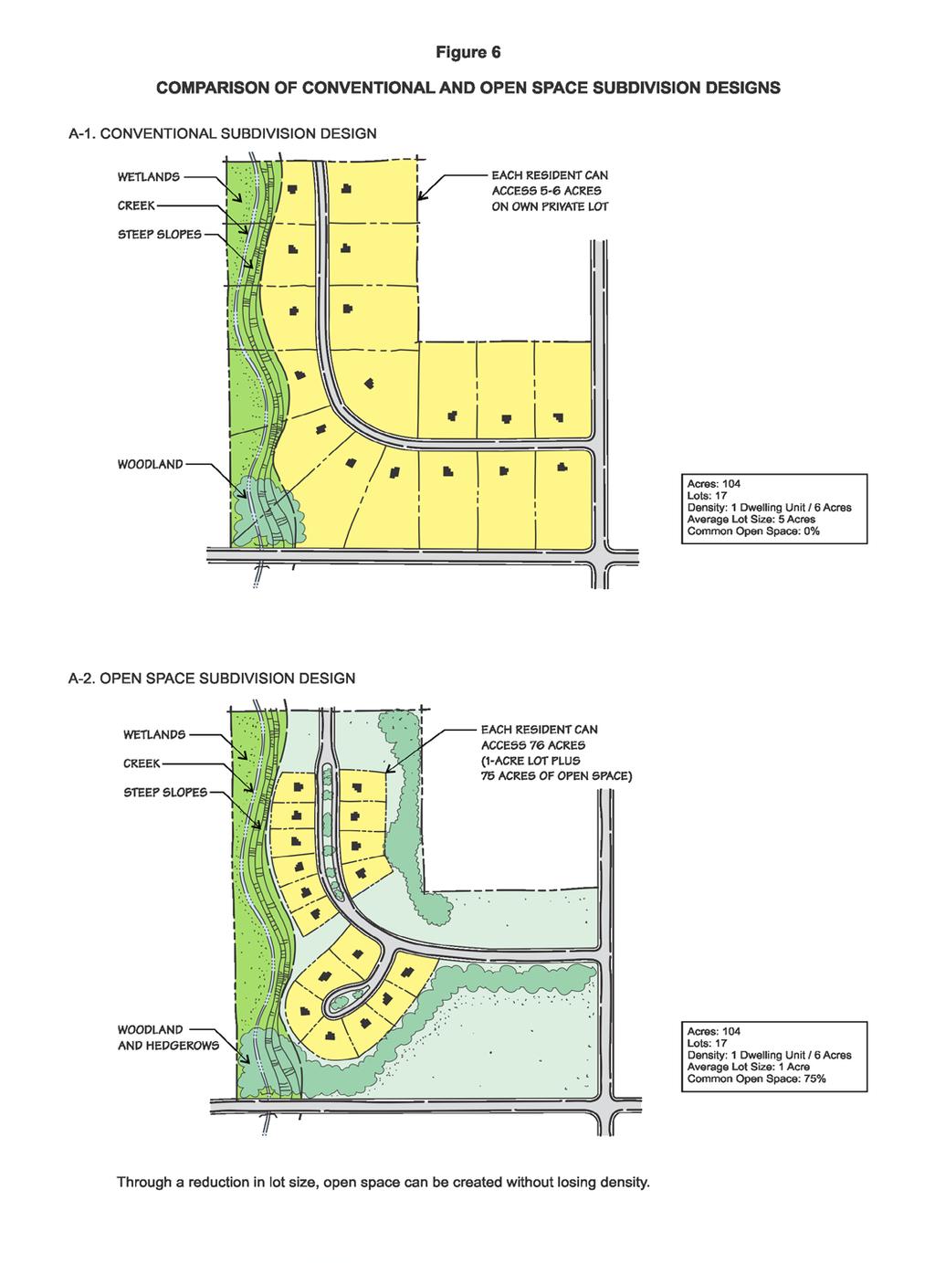
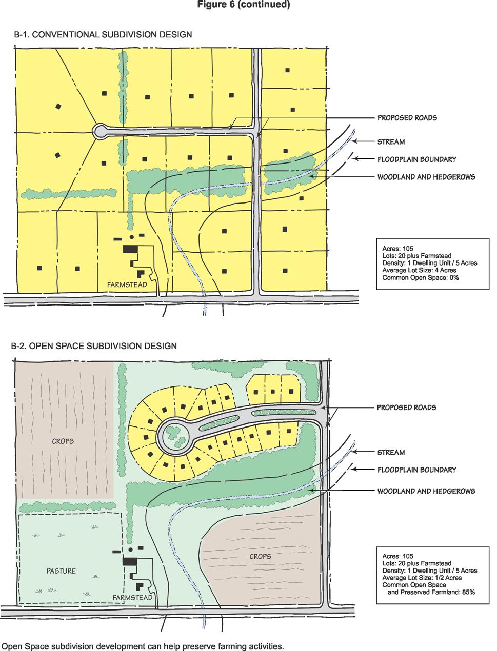
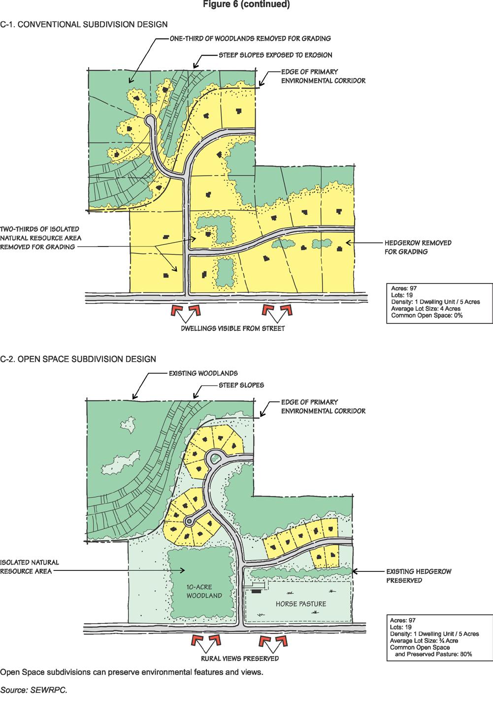
7 The street and lot layout at this stage in the design process is conceptual only. Because of the large variety of street layouts that are possible through the flexibility permitted by open space subdivision regulations, agreement on the general acceptability of a plan should be reached before the plan is more precisely detailed. While general municipal engineering principles should be followed, no detailed site engineering is done at this stage, although all zoning and subdivision regulations should be consulted to determine achievability of the proposed development concepts. It is beneficial for both the developer and the municipality to reach a consensus on a conceptual sketch plan before the developer incurs the costs of preliminary engineering. During review of the sketch plan, design changes can be made at little cost to the developer, lesser review time by the municipality, and with frustrations minimized. Thus, before the preparation of a preliminary plat is initiated, both the developer and the municipality should have agreed upon a conceptual layout. The result of this process will be that streets and houses blend into the landscape in a natural way that protects the character of the site as seen within the site and from adjacent streets. This is again the opposite of houses being forced onto the landscape in a form determined by rigid lot sizes and the configuration of parcel boundaries, as is often the case in conventional subdivision design and development. EXAMPLES OF OPEN SPACE SUBDIVISION DESIGNS Hypothetical examples of open space subdivision designs, contrasted with conventional designs for the same site, are presented in Figure 6. Additional examples of open space subdivision designs, along with means for implementing the open space subdivision design concept, are presented in SEWRPC Planning Guide No. 7, Rural Cluster Development, December
8 8
9 9
10 10
APPENDIX A 6 CONCEPTUAL PRELIMINARY PLAN GUIDE AND CHECKLIST FOR MAJOR SUBDIVISIONS CARRBORO DEVELOPMENT GUIDE APPENDIX A
 6 CONCEPTUAL PRELIMINARY PLAN GUIDE AND CHECKLIST FOR MAJOR SUBDIVISIONS Conceptual Preliminary Guide/Checklist for Major Subdivisions Page 1 FORM: REVIEW DATE: CONCEPTUAL PLAN REVIEW 2000 REVIEWED BY:
IV. Development in the Rural Overlay District
 Intracoastal Waterway Route 17 Route 168 Great Dismal Swamp VIRGINIA NORTH CAROLINA IV. Development in the Rural Overlay District IV-1 Route 17 in Chesapeake s Rural Overlay District affords distant views
Major Subdivision Sketch Plan Checklist
 This checklist provides specific requirements that are apart of the Sketch process. The entire process is described by the Huntersville Subdivision Review Process which details all the submittal and resubmittal
CHAPTER 22 Rural Open Space Community Developments
 CHAPTER 22 Rural Open Space Community Developments Section 22.1 Description and Purpose The intent of this Chapter is to offer property owners an alternative to traditional zoning requirements for rural
Chapter 10 IMPLEMENTATION RECOMMENDATIONS
 Chapter 10 IMPLEMENTATION RECOMMENDATIONS The recommended land use plan presented in the previous chapter provides a design for the attainment of the urban and rural development and open space preservation
Exhibit A. 8:9 Scuffletown Rural Conservation District
 Exhibit A 8:9 Scuffletown Rural Conservation District 8:9.1 Intent and Purpose The Scuffletown Rural Conservation (SRC) District is intended to provide for residential development that supports the development
Environmental Protection Ordinances (Performance Zoning) Bedminster Township, Bucks County
 Bedminster Township, Bucks County") Environmental Protection Ordinances (Performance Zoning) Bedminster Township, Bucks County ARTICLE VI. PERFORMANCE STANDARDS Section 600 Compliance All uses, activities, subdivisions and/or land developments
Environmental Protection Ordinances (Performance Zoning) Bedminster Township, Bucks County ARTICLE VI. PERFORMANCE STANDARDS Section 600 Compliance All uses, activities, subdivisions and/or land developments
Town of Peru Comprehensive Plan Executive Summary
 Town of Peru Comprehensive Plan Executive Communities that plan grow by choice, not by chance. A plan makes growth thoughtful, understandable, and predictable. A plan shows that a community is managing
Design Guidelines. for Conservation Subdivisions For Conservation Subdivisions. Town of Wallkill New York. in Wallkill, NY. in Wallkill, New York
 Design Guidelines Guidelines for Conservation Subdivisions For Conservation Subdivisions in Wallkill, NY in Wallkill, New York Town of Wallkill New York December 2009 Design Guidelines for Conservation
Procedures IV. V. Rural Road Design Option
 i IV. Procedures A. All applicants required to prepare a Conservation Design Subdivision shall provide the Planning Board with a conceptual conventional subdivision design as well as a proposed layout
CHAPTER 4 FUTURE LAND USE AND URBAN SERVICES DISTRICTS
 CHAPTER 4 FUTURE LAND USE AND URBAN SERVICES DISTRICTS Introduction This chapter discusses how Benzie County should grow and change in the future. A community can grow and change in many different ways.
Riparian Buffer on the Bushkill Creek. Policies
 Riparian Buffer on the Bushkill Creek Riparian buffers provide numerous benefits to landowners and the community by protecting groundwater recharge areas, providing flood control, providing stormwater
Minnesota Department of Natural Resource - Natural Resource Guidance Checklist Conserving Natural Resources through Density Bonuses
 Minnesota Department of Natural Resource - Natural Resource Guidance Checklist Conserving Natural Resources through Density Bonuses NRDB Why Use Density Bonuses & This Checklist Local units of government
Section 4 BUILDING THE MASTER PLAN
 The Master Plan 33 Section 4 BUILDING THE MASTER PLAN Figure 4:1. A collaborative effort characterized the two design workshops sponsored by DISC to create hypothetical Master Plans for the Towers Property
COMMUNITY DESIGN. GOAL: Create livable and attractive communities. Intent
 COMMUNITY DESIGN Intent An attractive, well-designed County will attract quality development, instill civic pride, improve the visual character of the community, and create a strong, positive image for
ARTICLE VI AGRICULTURAL PROTECTION DISTRICT
 A. Findings and Purpose ARTICLE VI AGRICULTURAL PROTECTION DISTRICT The Town of Northumberland finds that the protection of agriculture is essential to the implementation of the goals and objectives ofthe
Conservation Development
 Acknowledgements RIDEM: Scott Millar Anthony Lachowicz-Planning and Zoning Consultant Director of Planning 1 : a creative land use technique that allows a community to guide growth to the most appropriate
A Guide to Open Space Design Development in Halifax Regional Municipality
 A uide to Open Space Design Development in Halifax Regional Municipality May 2007 1 Introduction Pursuant to Section 3.5 of the Regional Municipal Planning Strategy (RMPS), subdivision of land may proceed
Rural Land Use Designations Kittitas County December 6, 2007 Draft
 KITTITAS COUNTY COMMUNITY DEVELOPMENT SERVICES 411 N. Ruby St., Suite 2, Ellensburg, WA 98926 CDS@CO.KITTITAS.WA.US Office (509) 962-7506 Fax (509) 962-7682 Rural Land Use Designations Kittitas County
HAZARD MITIGATION GOALS AND OBJECTIVES
 SEWRPC Community Assistance Planning Report No. 282, 2nd Edition CITY OF MILWAUKEE ALL HAZARDS MITIGATION PLAN UPDATE Chapter IV HAZARD MITIGATION GOALS AND OBJECTIVES [NOTE: Throughout this plan update
TOWN OF SPRINGFIELD, NEW HAMPSHIRE
 TOWN OF SPRINGFIELD, NEW HAMPSHIRE NATURAL RESOURCES INVENTORY EXECUTIVE SUMMARY March 2008 Prepared by: Watershed to Wildlife, Inc. Natural Resource Consultants 42 Mill Street, Suite 3 Littleton, NH 03561
Tools for Managing Local Drainage Issues: Land Use Regulations / Driveway Standards.
 Tools for Managing Local Drainage Issues: Land Use Regulations / Driveway Standards. The purpose of our program is to help Planning Board members, ZBA members and CEO s understand that: Local land use
CITY OF SCANDIA ORDINANCE NO. 174
 CITY OF SCANDIA ORDINANCE NO. 174 AN ORDINANCE AMENDING ORDINANCE NO. 122, THE SCANDIA DEVELOPMENT CODE, CHAPTER 2, SECTION 4.34, REGARDING SOLAR FARMS AND COMMUNITY SOLAR GARDENS The City Council of the
PARK CITY MUNICIPAL CODE TABLE OF CONTENTS TITLE 15 LAND MANAGEMENT CODE - CHAPTER 2.21
 PARK CITY MUNICIPAL CODE TABLE OF CONTENTS TITLE 15 LAND MANAGEMENT CODE - CHAPTER 2.21 TITLE 15 - LAND MANAGEMENT CODE CHAPTER 2.21 - SENSITIVE LAND OVERLAY ZONE (SLO) REGULATIONS 15-2.21-1. PURPOSE...1
STREAM BUFFERS
 88-415 STREAM BUFFERS 88-415-01 PURPOSE In the Kansas City region and throughout the nation, vegetated stream buffers have been clearly shown to protect stream stability and related infrastructure, improve
Part 5. Environmental Protection Overlay District Regulations
 Part 5 Environmental Protection Overlay District Regulations Section 501. Statement of Intent. As established through the goals, objectives and policies of the Amity Township Comprehensive Plan, it is
CONSERVATION SUBDIVISIONS & SITE DESIGN
 CONSERVATION SUBDIVISIONS & SITE DESIGN A Presentation for the 2008 Tennessee Farmland Legacy Conference By the Tennessee Local Planning Assistance Office Department of Economic and Community Development
SECTION II SECTION II STATEMENT OF GOALS, OBJECTIVES, PRINCIPLES, ASSUMPTIONS, POLICIES AND STANDARDS
 STATEMENT OF GOALS, OBJECTIVES, PRINCIPLES, ASSUMPTIONS, POLICIES AND STANDARDS 1 2 STATEMENT OF GOALS, OBJECTIVES, PRINCIPLES, ASSUMPTIONS, POLICIES AND STANDARDS INTRODUCTION The New Jersey Municipal
Checklists. Project Name: Location: File Number: Date of Submittal: Reviewer: Date: Applicant: Contact Name: Phone Number:
 Applicant: Contact Name: Phone Number: Email: Project Name: Location: File Number: Date of Submittal: Reviewer: Date: Concept Plan Requirements: I. General Project Information 1. Address or parcel number
O l so n M e morial Highway, S t e , G o l d e n V a l l e y, MN Delano Laketown Homes Concept Plan
 N O R T H W E S T A S S O C I A T E D C O N S U L T A N T S, I N C. 4 1 5 0 O l so n M e morial Highway, S t e. 3 2 0, G o l d e n V a l l e y, MN 5 5 4 2 2 T e l e p h o n e : 7 6 3. 9 5 7. 1 1 0 0 W
When planning stormwater management facilities, the following principles shall be applied where possible.
 2.0 Principles When planning stormwater management facilities, the following principles shall be applied where possible. 2.0.1 Drainage is a regional phenomenon that does not respect the boundaries between
SENSITIVE LANDS OVERLAY
 SENSITIVE LANDS OVERLAY Chapter 22 Sensitive Lands Overlay 22.1 PURPOSE 22.2 APPLICATION AND ANALYSIS REQUIREMENTS 22.3 SENSITIVE LAND REGULATIONS 22.4 ADMINISTRATIVE PROVISIONS 22.5 DESIGN STANDARDS 22.6
ARTICLE IV: DEVELOPMENT STANDARDS 404 MASTER PLANNING
 IV 13 404 MASTER PLANNING Master Planning through the Site Analysis (Master Planning Site Analysis) or Planned Development (Master Planning Planned Development) is provided to encourage development which
CROWN POINT SUBDIVISION
 CROWN POINT SUBDIVISION A COMPARISON OF CONVENTIONAL VERSUS CONSERVATION SUBDIVISION DESIGN DEVELOPER: PAUL LUCIANO BUILDERS LAND PLANNING & DESIGN: DAVID LAIRD ASSOCIATES FUNDING PROVIDED BY: PA SEA GRANT
Chapter 131 GENERAL REFERENCES
 Chapter 131 STREAM CORRIDOR PROTECTION ZONE 131-1. Objectives. 131-2. Definitions. 131-3. Establishment of the Stream Corridor Protection Zone. 131-4. Uses permitted. 131-5. Uses expressly prohibited.
Planning for and Managing Open Space and Natural Areas
 Planning for and Managing Open Space and Natural Areas Increasingly, development proposals in Delaware include large amounts of open space and natural areas. While open space is important as a community
Land Use. Chapter 8: Introduction. Land Use Vision. Section I: Current Land Use 8-1
 Introduction Land use is the defining element of the comprehensive plan. It will serve as a framework for decision makers, guiding future growth and development in the Town of Oconto Falls. This chapter
Mitchell Ranch South MPUD Application for Master Planned Unit Development Approval Project Narrative. Introduction
 Mitchell Ranch South MPUD Application for Master Planned Unit Development Approval Project Narrative Introduction Mitchell Ranch South is a proposed single family (detached) residential development on
Draft Stillwater 2030 Comprehensive Plan- Goals and Policies
 Draft Stillwater 2030 Comprehensive Plan- Goals and Policies Instructions- Review each goal and policy and discuss with group any changes, deletions for additions to the list using your groups pen. Keep
E. RURAL COMMERCIAL/INDUSTRIAL PARK MODEL
 E. RURAL COMMERCIAL/INDUSTRIAL PARK MODEL 1. PURPOSE The purpose of the Rural Commerce/Industrial Park Model is to provide parameters within which a grouping of business buildings with parking, loading
Regulation Changes for Open Space and Similar Uses
 Regulation Changes for Open Space and Similar Uses What is the Project? This project is an analysis of the Zoning Ordinance relating to public lands and open space regulations. The proposed text amendments
Improve Neighborhood Design and Reduce Non Point Source Water Pollution
 HOW TO Planning Guide Improve Neighborhood Design and Reduce Non Point Source Water Pollution This document was funded by a grant from the New Hampshire Coastal Program with funding from the National Oceanic
Plan on It! ENVIRONMENTAL CORRIDORS
 Plan on It! ENVIRONMENTAL CORRIDORS LIFELINES OF THE NATURAL RESOURCE BASE A SERIES OF FACT SHEETS ON REGIONAL PLANNING ISSUES IN SOUTHEASTERN WISCONSIN WHAT ARE THEY? Environmental corridors are areas
Richton Park Western Development Corridor Green Infrastructure Development Plan August 18, 2017
 Richton Park Western Development Corridor Green Infrastructure Development Plan August 18, 2017 Conservation Design Forum Geosyntec Consultants 403 W. St. Charles Road 1420 Kensington Road, Suite 103 Lombard,
-MENDOCINO COUNTY PLANNING AND BUILDING SERVICES- DIVISION II OF TITLE 20--COASTAL ZONING CODE
 CHAPTER 20.504 VISUAL RESOURCE AND SPECIAL TREATMENT AREAS Sec. 20.504.005 Applicability. Sec. 20.504.010 Purpose. Sec. 20.504.015 Highly Scenic Areas. Sec. 20.504.020 Special Communities and Neighborhoods.
Example Codes. City of Brentwood, Tennessee Brentwood Hillside Protection Overlay District Summary
 Example Codes City of Brentwood, Tennessee Brentwood Hillside Protection Overlay District Summary The City of Brentwood in July 2007 adopted a Hillside Protection (HP) Overlay District to address the problems
GENERAL PLAN UPDATE ISSUES MEETING. January 21, 2010 City Hall Mitchell Room 6:00 pm 9:00 pm
 GENERAL PLAN UPDATE ISSUES MEETING January 21, 2010 City Hall Mitchell Room 6:00 pm 9:00 pm WELCOME! Introductory Comments Continued Review of Quality of Life Standards, Growth Management, Proposition
Conservation Plan. I. Property Information. II. Objectives. Natural Resource Objectives. Sustainability in Practice (SIP) Certified
 Certified") Conservation Plan Sustainability in Practice (SIP) Certified I. Property Information Vineyard Name and Establishment Date: Location: Map (attach showing blocks and acres): II. Objectives Natural Resource
Conservation Plan Sustainability in Practice (SIP) Certified I. Property Information Vineyard Name and Establishment Date: Location: Map (attach showing blocks and acres): II. Objectives Natural Resource
Shoreland Zoning. Kay Lutze Shoreland Zoning Policy Coordinator
 Shoreland Zoning Kay Lutze Shoreland Zoning Policy Coordinator Kay.Lutze@wisconsin.gov Purposes of shoreland zoning include Prevent and control water pollution Protect spawning grounds, fish and aquatic
Zoning Ordinance Article 3
 Article 3 Natural Resources Protection Section 301 Natural Resources Protection 301.1. Purpose - The following natural resources protection standards are established to protect the public health, safety
COMMUNITY ENVIRONMENTAL MANAGEMENT
 COMMUNITY ENVIRONMENTAL MANAGEMENT CEM HANDBOOK FOR COMMUNITY CONSERVATION PLANNING ----- Draft ----- Prepared by the CENTER FOR COMMUNITY ENVIRONMENTAL MANAGEMENT in association with the NEW YORK STATE
PRELIMINARY REPORT. HIGHWAY 18 CORRIDOR NEIGHBORHOOD PLAN VILLAGE OF DOUSMAN November, 2014
 PRELIMINARY REPORT HIGHWAY 18 CORRIDOR NEIGHBORHOOD PLAN VILLAGE OF DOUSMAN November, 2014 This preliminary report presents the initial recommendations for land use within the Highway 18 corridor along
WASHINGTON COUNTY OREGON
 WASHINGTON COUNTY OREGON LONG RANGE PLANNING DIVISION North Bethany Subarea Stream Corridors: Existing Regulations In Oregon, there is a distinct difference between the land use rules that apply in rural
Implementation Vision
 Introduction The implementation chapter is the how to portion of the plan. It describes the actions necessary to realize the visions presented in this document through the goals, objectives, and policies
PLANNED UNIT DEVELOPMENT PUD For The Proposed Antietam Subdivision Escambia County, Florida. Introduction
 PLANNED UNIT DEVELOPMENT PUD For The Proposed Antietam Subdivision Escambia County, Florida Introduction The project is located in Escambia County approximately 0.75 + miles north of the US Highway 90,
Table IX-1 LAND USES IN WASHINGTON COUNTY: 2006
 #128550 v1 - WASH CO CP TBL I-1 2006 LU NMA/RLR 12/21/07 Table I-1 LAND USES IN WASHINGTON COUNTY: 2006 Note: This table, and the accompanying map, is more general than the land use inventory conducted
Planned Residential Neighborhoods Land Use Goals
 Planned Residential Neighborhoods Land Use Goals Issue: Guidelines that provide for diverse high quality residential areas that include a variety of housing styles and layouts are needed. Goal 1: Create
2.1 Principles & Objectives
 Designing With The Landform 2.1 Principles & Objectives Land planning which integrates the natural features of a site (i.e., designing with the landform ) into the site design is a major component of the
AREASTRUCTURE PLAN AMENDMENT COCHRANE NORTH
 AREASTRUCTURE PLAN AMENDMENT COCHRANE NORTH In order to implement the vision outlined in the Conceptual Scheme, the following three amendments to the Cochrane North ASP are proposed: 1. Allow commercial
ST. MARY S SOIL CONSERVATION DISTRICT (SMSCD) AND DPW&T CONCEPT EROSION AND SEDIMENT CONTROL AND STORMWATER MANAGEMENT GUIDELINES AND CHECKLIST
 AND DPW&T CONCEPT EROSION AND SEDIMENT CONTROL AND STORMWATER MANAGEMENT GUIDELINES AND CHECKLIST") St. Mary s Soil Conservation District 26737 Radio Station Way, Suite B Leonardtown, MD 20650 Phone: 301-475-8402 ext. 3 Fax: 301-475-8391 www.stmarysscd.com St. Mary s County Government Department of Public
St. Mary s Soil Conservation District 26737 Radio Station Way, Suite B Leonardtown, MD 20650 Phone: 301-475-8402 ext. 3 Fax: 301-475-8391 www.stmarysscd.com St. Mary s County Government Department of Public
Leduc Industrial Outline Plan SE W4
 Leduc Industrial Outline Plan SE 1-50-25-W4 Within the North Leduc Industrial ASP Prepared for: Leduc Energy Park Ltd. Prepared by: Stantec Consulting Ltd. File No. 1161 104655 V5 Table of Contents 1.0
Chapter 3 Site Planning and Low Impact Development
 CHAPTER 3 Site Planning and Low Impact Development Chapter 3 Site Planning and Low Impact Development 3.0 Introduction The City of Charleston requires that major residential, large commercial (>1 acre),
LAND USE ELEMENT. Purpose. General Goals & Policies
 LAND USE ELEMENT Purpose This Land Use Element contains the goals and policies necessary to support the City s responsibility for managing land resources and guiding development through implementing regulations,
Section 3 Non-Structural BMPs
 3.1 Stream Buffers A stream buffer or stream setback is a designated area around a stream, lake, or wetland left in a natural, densely vegetated state so as to protect the receiving water quality and provide
Approved 8/18/94 Revised 3/21/02 Revised 5/14/09
 Approved 8/18/94 Revised 3/21/02 Revised 5/14/09 Guidelines for Calculation and Provision of Open Space in Developments of Regional Impact Technical Bulletin 94-001, as Amended Contents Introduction...2
Draft CHAPTER TWO THREE LAND USE PLAN
 CHAPTER TWO THREE LAND USE PLAN LAND USE PLAN The basic intent of the comprehensive planning process is to provide a well-founded and coordinated decision-making framework to guide both public and private
AMENDMENT NO. 30 TO THE OFFICIAL PLAN OF THE TOWN OF MILTON
 AMENDMENT NO. 30 TO THE OFFICIAL PLAN OF THE TOWN OF MILTON Subject: Boyne Survey Secondary Plan and Related Official Plan Amendments The following text and schedules constitute Amendment No. 30 to the
Stormwater Retrofitting: The Art of Opportunity. Presented by the Center for Watershed Protection
 Stormwater Retrofitting: The Art of Opportunity Presented by the Center for Watershed Protection What Are Stormwater Retrofits? Retrofits are stormwater management measures inserted in an urban or ultra-urban
Zoning Ordinance Chapter 10
 CHAPTER 10 - WASHES SECTION 10.0 GENERAL: A. The purpose of this Ordinance is to establish standards for development in or near Major and Minor Washes as defined in Appendix A Glossary of Terms and Definitions
7.0 SOCIAL, ECONOMIC, AND ENVIRONMENTAL ISSUES
 7.0 SOCIAL, ECONOMIC, AND ENVIRONMENTAL ISSUES The following list of social, economic, and environmental issues have been identified based on a preliminary inventory of resources in the project area, an
CITY OF INVER GROVE HEIGHTS 8150 Barbara Avenue Inver Grove Heights, MN (651) Fax: (651)
 Fax: (651)") CITY OF INVER GROVE HEIGHTS 8150 Barbara Avenue Inver Grove Heights, MN 55077 (651) 450-2545 Fax: (651) 450-2502 www.invergroveheights.org SKETCH PLAN REVIEW APPLICATION FOR THE NORTHWEST AREA OVERLAY
CITY OF INVER GROVE HEIGHTS 8150 Barbara Avenue Inver Grove Heights, MN 55077 (651) 450-2545 Fax: (651) 450-2502 www.invergroveheights.org SKETCH PLAN REVIEW APPLICATION FOR THE NORTHWEST AREA OVERLAY
OP Council Resolution June 16, Planning and Development Services
 OP-08-01 Council Resolution June 16, 2008 Planning and Development Services Kingsgate Landing Outline Plan Table of Contents 1.0 Introduction 1 1.1 Purpose of Plan 1 1.2 Plan Area Location 1 1.3 Ownership
Rule D Wetland and Creek Buffers
 Rule D Wetland and Creek Buffers 1 Policy It is the policy of the Board of Managers to ensure the preservation of the natural resources, recreational, habitat, water treatment and water storage functions
Mendota Heights 2040 Comprehensive Plan Draft Vers
 4 Parks and Trails The City of Mendota Heights boasts a variety of recreational and open space opportunities. Few cities can claim access to regional trails, riverside and lakeside parks, scenic bluffs
EXHIBIT B PROJECT NARRATIVE POULSBO MEADOWS
 EXHIBIT B PROJECT NARRATIVE POULSBO MEADOWS Name of Project: Poulsbo Meadows; A Planned Residential Development (PRD)/Plat Applicants Name: PBH Group LLC/Byron Harris PO Box 1010 Silverdale, WA 98038 Description
Sanford/Lee County Technical Review Committee (TRC) DEADLINES & MEETING DATES
 DEADLINES & MEETING DATES") Sanford/Lee County Technical Review Committee (TRC) DEADLINES & MEETING DATES The following 2019 information is based on the information available to staff at the time of creation. Dates & time may change
Sanford/Lee County Technical Review Committee (TRC) DEADLINES & MEETING DATES The following 2019 information is based on the information available to staff at the time of creation. Dates & time may change
TRCA Field Staking Protocol December 2016
 Page 1 of 6 TRCA Field Staking Protocol December 2016 This Protocol describes TRCA staff s current practice for field staking the physical top of bank, the physical toe of slope, and the limit of existing
Whitemarsh Township Greenway Plan
 Whitemarsh Township Greenway Plan Prepared for: Whitemarsh Township August 16, 2007 Table of Contents Table of Contents... i Introduction... 1 Study Area Setting... 2 Regional Setting... 2 Township Character...
Applicant Name Phone / Fax / Address City State Zip Code . Property Owner Phone / Fax / Address City State Zip Code
 Master Development Plan Application Community Development Department City of Redmond 411 SW 9 th Street Redmond, Oregon 97756 541-923-7721 541-548-0706 FAX Master Development Plan Fee $38,862.52 File Number
Chapter 5: Natural Resources and Environment
 NATURAL RESOURCES AND ENVIRONMENT 5-1 5 Chapter 5: Natural Resources and Environment BACKGROUND AND INTENT Urban expansion represents the greatest risk for the future degradation of existing natural areas,
LAND USE Land Use 219
 3.2 2040 LAND USE One purpose of the 2040 Plan is to provide a public policy basis for making decisions regarding growth and development in the County. The number, size, and complexity of land use proposals
Green Infrastructure Policies and Ordinances
 Green Infrastructure Policies and Ordinances October 23, 2013 By Karen Firehock, Green Infrastructure Center 2013 Georgia Urban Forest Council s 23 rd Annual Conference The mission of the nonprofit Green
Woodland Conservation and the Master Plan
 1 WHAT IS A MASTER PLAN? A Vision for the Future of Your Community Woodland Conservation and the Master Plan Goals Objectives Strategies 2 How Will Your Community Look? TREE PRESERVATION AND THE MASTER
City of Lafayette Study Session Staff Report Design Review Commission
 ++ City of Lafayette Study Session Staff Report Design Review Commission Meeting Date: January 08, 2018 Staff: Subject: Chris Juram, Planning Technician SS12-17 Miramar Homebuilders, R-20 Zoning: Request
Pennsylvania Stormwater Best Management Practices Manual
 Pennsylvania Stormwater Best Management Practices Manual DRAFT - JANUARY 2005 Section 4 Comprehensive Stormwater Management: Integrating Site Design, Non-Structural, and Structural BMP's This page intentionally
ARTICLE 6: Special and Planned Development Districts
 ARTICLE 6: Special and Planned Development Districts 6-10 Traditional Neighborhood Development (TND) District 6-10.10 Purpose and Intent The Traditional Neighborhood Development (TND) District provides
St. Croix County Shoreland Overlay Zoning Districts. Public Hearing Community Development Committee December 19, 2013
 St. Croix County Shoreland Overlay Zoning Districts Public Hearing Community Development Committee December 19, 2013 Timeline CDC Review October 17 Public Information Meeting October 29 (6:00-8:00 pm)
Chapter IV: Development Pattern
 Chapter IV: Development Pattern Introduction The 2002 Prince George s County Approved General Plan designates three growth policy tiers Developed, Developing, and Rural as well as three center designations
Net Land Area (NLA): Area within zoning lot boundaries NLA= sq. ft. a) Credited Street Area (total adjacent frontage) x ½ width of public rightof-way
: Area within zoning lot boundaries NLA= sq. ft. a) Credited Street Area (total adjacent frontage) x ½ width of public rightof-way") PROJECT FACT SHEET Section A: Project Information Application type: Date: Project Name: Use Type: (check/list all that apply) Office/Institutional Residential Mixed-Use Other: Overlay District: (check
PROJECT FACT SHEET Section A: Project Information Application type: Date: Project Name: Use Type: (check/list all that apply) Office/Institutional Residential Mixed-Use Other: Overlay District: (check
Plat Requirements CHECKLIST FOR SITE PLAN REVIEW
 This checklist is to be used as a guide for complying with the Town of Hollis Site Plan Regulations. It is to be used for each individual site plan review application submitted. Applicants are encouraged
9.0 EXISTING LAND USE
 9.0 EXISTING LAND USE Table of Contents Introduction...117 Existing Land Use and Zoning...117 Existing Land Use Breakdown...117 Town of Nekimi Existing Land Use Map...119 Town of Nekimi Zoning Map...121
Chapter 13: Implementation Plan
 Implementation A. Introduction The Implementation Plan, in table form on the following pages, provides a summary of all the Action Items recommended in Chapters 2 through 12. The table also indicates which
Capital Area Regional Planning Commission. DANE COUNTY LAND USE & TRANSPORTATION PLAN Amended Goals and Objectives
 Capital Area Regional Planning Commission DANE COUNTY LAND USE & TRANSPORTATION PLAN Amended Goals and Objectives CARPC Redline Review Draft 12/14/07 as amended and adopted on 2/28/08* *changes indicated
DRAFT SCOPE FOR THE DRAFT ENVIRONMENTAL IMPACT STATEMENT FOR HUDSON HIGHLANDS RESERVE TOWN OF PHILIPSTOWN, NEW YORK June 5, 2018
 DRAFT SCOPE FOR THE DRAFT ENVIRONMENTAL IMPACT STATEMENT FOR HUDSON HIGHLANDS RESERVE TOWN OF PHILIPSTOWN, NEW YORK June 5, 2018 Project Name: Project Location SEQRA Classification of Project: Lead Agency:
Future Land Use and Development Policies
 Future Land Use and Development Policies Introduction This section presents policies for future development and land use, given the consensus identified through the extensive public participation process.
A Growing Community Rural Settlement Areas
 Town of Huntsville Official Plan Review - POLICY BACKGROUND PAPER A Growing Community Rural Settlement Areas BACKGROUND: In addition to the fully municipally-serviced Urban Settlement Area and the Hidden
Regional Context Statement
 Regional Context Statement REGIONAL CONTEXT STATEMENT 3. REGIONAL CONTEXT STATEMENT In 1995, the Provincial Government passed into law the Growth Strategies Act. The purpose of this provincial initiative
VILLAGE & TOWN OF BERGEN: COMPREHENSIVE PLAN
 VILLAGE & TOWN OF BERGEN: COMPREHENSIVE PLAN CPC Public Hearing April 21, 2016 History 1996 Comprehensive Plan Comprehensive Plan Update Committee Consultant (LaBella Associates): December 2014 Residents
PART 1: PROJECT SUMMARY. The application is Attachment A. The site plan is Attachment B.
 Belleterre Subdivision Sketch Plan Town Board 8.7.17 Belleterre Subdivision Sketch Plan PART 1: PROJECT SUMMARY Applicant: Bowman Development Project Size: +/- 20.85 acres Parcel Number: 01115104 and 01115121
Open Space Element. General Plan. County of Sacramento Community Planning and Development Department
 General Plan Open Space Element Adopted December 15, 1993 Amended November 9, 2011 County of Sacramento Community Planning and Development Department This Page blank. Table of Contents SECTION I... 1 OPEN