Preliminary Recommendations
|
|
|
- Amberly Singleton
- 5 years ago
- Views:
Transcription
1 Preliminary Recommendations

2 Plan Area 2

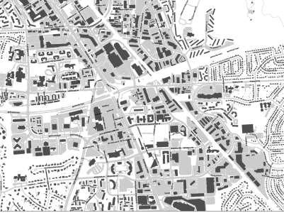
3 Plan Context White Flint White Flint Sector Plan 2009 Twinbrook Sector Plan 3

4 Plan Context 4

5 Plan Context White Flint Residential Non-Residential Sector Plan Recommendation White Flint Sector Plan- Phase 1 9,800 dwelling units 5.69 million sq.ft. 3,000 dwelling units 2.0 million sq.ft. Staging Allocated Development-Phase1 861 dwelling units 387, 640 sq.ft. Remaining Phase 1 2,139 dwelling units 1.61 million sq.ft. White Flint Residential Non-Residential White Flint Height and Density Approved Pipeline 1. LCOR-North Bethesda Center-Partially Built 2. North Bethesda Market (NoBe)-Built 3. Metro Pike Holladay (Saul Centers- Westside)-Unbuilt 4. White Flint View -Unbuilt Sector Plan Pipeline 2,220 dwelling units 1.8 million sq.ft. Built Pipeline Development Remaining Pipeline Development 1,064 dwelling units 623,068 sq.ft. 1,156 dwelling units 1.17 million sq.ft. White Flint Residential Non-Residential Remaining Sector Plan Recommendation and Pipeline 10,095 dwelling units 6.47 million sq.ft. 5

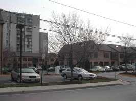
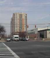
6 Existing Land Use City of Rockville Twinbrook WF2 WF2 White Flint Built Development Residential Non-Residential 1,904 dwelling units 6.4 million sq.ft 6

7 Existing Plan Area Zones 7


8 Public Outreach Public meetings Schools Parks and open spaces Transportation Property owners and civic/home associations Advocates 8

9 1992 North Bethesda Plan new development within districts focused around transit nodes.to establish a balance between auto and transit access by designing for non-auto movement within walking distance of transit stops North Bethesda/Garrett Park Master Plan 9


 Goal:")

10 Preliminary Recommendations 2009 Twinbrook Sector Plan Goal: Build a technology node using synergy between existing government agencies and maintaining existing industrial area for incubator activities. Urban Design Context Twinbrook 2010 White Flint Sector Plan Goal: Transform a car-oriented area into an urban and diverse mixed-use area centered on transit. Rockville s Pike Plan Update (2016 Draft) Goal: Transform a portion of the Rockville Pike corridor into an attractive and vibrant neighborhood for shopping, living, and working. NORTH White Flint


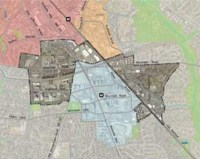
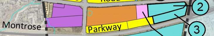
11 Preliminary Recommendations Montrose North/MD 355 Twinbrook Station Development Rockville s Pike Plan Update 2009 Twinbrook Sector Plan WF2 Key Properties White Flint 2 Sector Plan 2010 White Flint Sector Plan NORTH Recommendations: To transform a car-centric area into a mixed-use, pedestrian friendly location. Focus redevelopment along Rockville pike to extend ongoing efforts to transform the corridor north and south through the plan area. Improving the area for pedestrians by introducing activating uses along the Pike. Integrate into new development spaces for public use, connected to the Pike and accessible to existing and future residents.


12 Preliminary Recommendations Executive Boulevard White Flint 2 Sector Plan Montrose Parkway Pike & Rose NORTH WF2 Key Properties Executive Blvd White Flint Sector Plan Recommendations: New development should enhance Executive Boulevard for pedestrians and introduce street activating uses and open spaces for public use. Focus redevelopment to support ongoing County priorities, such as the realignment of Executive Blvd. and Old Georgetown Road. Develop vacant land north of Montrose Parkway to connect with northern part of the planning area. Introduce new uses that complement existing remaining uses, and that take advantage of existing natural resources.


13 Preliminary Recommendations Parklawn Drive / Randolph Hills 2009 Twinbrook Sector Plan Light Industrial Area White Flint 2 Sector Plan WF2 Key Properties NORTH 2010 White Flint Sector Plan Recommendations: Redevelopment should incorporate the character of the adjacent industrial area, to create neighborhood serving centers that are unique to this cluster. Define and activate open spaces for community use. Promote the enhancement of bike and pedestrian connections related to potential redevelopment sites.
14 Preliminary Recommendations Design Guidelines

15 Preliminary Recommendations CONSOLIDATE FRONTAGES TO IMPROVE PEDESTRIAN AREAS RETAIN LIGHT INDUSTRIAL USES POTENTIAL MIXED-USE POTENTIAL OPEN SPACE LIGHT INDUSTRIAL TO REMAIN Concept IMPROVEMENTS TO BRIDGE PEDESTIAN GAP BETWEEN NORTH AND SOUTH SIDES OF MMONTROSE PKWY> PEDESTRIAN CONNECTION THROUGH BUFFER NEIGHBORHOOD CENTER ROCKING HORSE ROAD CENTER POTENTIAL PUBLIC PARK LUXMANOR SCHOOL REDEVELOPMENT TO ANCHOR WESTERN WORKAROUND NEIGHBORHOOD CENTER WITH AN INDUSTRIAL FOCUS

16 Key Recommendations Land Use and Zoning Promote the transformation of single use commercial shopping centers into mixed-use places along Rockville Pike (MD 355). Integrate new residential and non-residential uses in the Executive Boulevard office park and promote mixed-use neighborhood centers at the Loehmann s Plaza and Randolph Hills Shopping Centers. Retain existing multi-family residential development as an important resource of market rate affordable housing. Retain light industrial properties to provide important services to down County residents, offer opportunities for small scale businesses, entrepreneurs, and vocational and entry-level employment. 16
17 Key Recommendations Affordable Housing Promote a diverse mix of housing options for residents at different stages of life. Retain existing multi-family residential development that furthers Montgomery County s Housing Element of the General Plan (2011) to provide a broad range of affordable housing options. 17
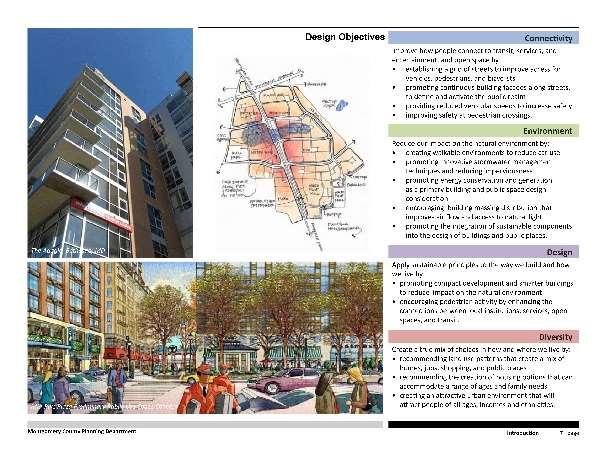
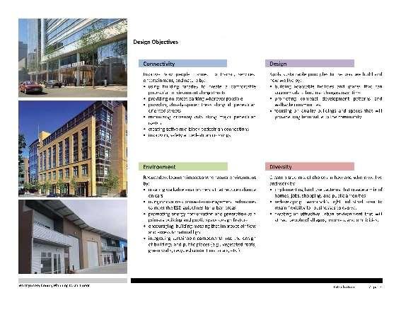
18 Key Recommendations Urban Design Provide design direction that recognizes the unique context and development challenges of individual areas such as Executive Boulevard, Rockville Pike, and other neighborhood centers identified by the Plan. Encourage design excellence for new development, including quality public use space that complements the guidance of the White Flint and Twinbrook Urban Design Guidelines. Promote walkability with new streets and enhanced streetscape to define the public realm. Promote variety in new building height and massing to maximize access to natural light and air circulation for building occupants, those of neighboring buildings, and surrounding communities and public open spaces. Twinbrook White Flint 18
19 Key Recommendations Mobility Extend the Rockville Pike (MD 355) Boulevard concept to the City limits of Rockville with Bus Rapid Transit (BRT). Provide new streets that permit alternative ways to navigate in the Plan area and to link to adjacent communities. Support the 2010 White Flint Sector Plan recommendation for a MARC Station but recognize that Maryland Department of Transportation (MDOT) must develop criteria for infill stations in Montgomery County. Support the expansion of the 2010 White Flint Sector Plan street network, where feasible. Accommodate new bikeways that link to the 2010 White Flint Sector Plan area and the City of Rockville. 19
20 Key Recommendations Parks and Open Space Create new parks and open spaces for public use to promote a livable environment for existing and future residents, visitors and employees, and to expand the network of interconnected open spaces envisioned by the 2010 White Flint Sector Plan. Link new parks and open spaces with existing and proposed bikeways and trails. Develop at least 12 acres of public use in the Plan area. 20

21 Key Recommendations Public Facilities Support the community facilities recommended in the 2010 White Flint Sector Plan. Provide recommendations to address school capacity issues in the Walter Johnson cluster. Promote the co-location of public facilities to reduce public expenditures and minimize land area. Encourage new prototypes for public facilities that promote innovate design. 21
22 Key Recommendations Sustainability Promote energy efficiency and encourage net zero energy building design. Improve the urban ecology, including goals to reduce heat island effect and promote Environmental Site Design (ESD) in stormwater management practices. Retain existing wooded areas where designated, and provide increased tree canopy throughout the Plan area. Include sustainable solutions in the design of an attractive public realm, to integrate green features, enhance mobility options, and promote walkability. 22
23 Key Recommendations Neighborhood Compatibility Provide adequate transitions between new development and existing neighborhoods through appropriate building heights and development intensities. Promote new pedestrian paths and bikeways between existing residential communities and new mixed-use development. 23

24 Metro Proximity 24
 and Executive")
25 Metro West and Pike & Rose Districts (2010) and Executive Boulevard 25
 and")

26 Metro West, Pike & Rose Districts (2010) and Executive Boulevard and Cherington White Flint 26

27 Overall Districts 2 Montrose North Randolph Hills 3 Parklawn South 4 1 Executive Blvd. 27


28 District: Executive Boulevard Existing Zone Executive Boulevard-North Executive Boulevard-South Proposed Zones 28


29 Realigned Executive Blvd Western Workaround Realigned Executive Blvd Willco Guardian Realty Towne Road Main/Market Street 29
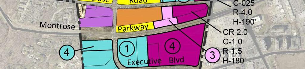
30 District: Cherington Existing Zones Proposed Zones CR 2.0 C1.0 R1.5 H


31 District: Montrose Village JDS JDS Existing Zones Proposed Zones 31


32 Pro District: JCC Existing Zones Proposed Zones CR 4.0 C0.25 R4.0 H190 EOF 1.0 H-75 Floating CRT Zone for the JCC property 32


33 District: Federal Plaza Existing Zones Proposed Zones CR 2.25 C0.75 R1.5 H150 33


34 Pro District: Montrose Crossing Existing Zones Proposed Zones Pike Center Pike Center Pike Center Montrose Crossing Montrose Crossing Montrose Crossing 34


35 District: White Flint 2 Industrial Existing Zones Proposed Zones Randolph Hills Shopping Center Floating CRT Zone for a portion of the Randolph Hills Shopping Center. Parklawn Drive 35


36 District: Loehmann s Plaza Existing Zones Proposed Zones Loehmann s Plaza Oxford Square Walnut Grove Parklawn 36 Drive


37 District: Rocking Horse Road Center Existing Zones Proposed Zones JDS Upper School Randolph Hills community 37


38 District: Montrose Baptist Existing Zones Proposed Zones Montrose Baptist 38
39 Land Use Alternatives Scenarios Residential Non-Residential Alternative 1 (Existing Zoning) 3,246 dwelling units 2.76 million sq.ft. Alternative 2 4,841 dwelling units 3.24 million sq.ft. Alternative 3 5,788 dwelling units 4.87 million sq.ft. Preliminary Recommendations Residential Non-Residential 5,189 dwelling units 3.53 million sq.ft 39

40 Preliminary Recommendations: Community Facilities Support the community facilities recommended in the 2010 White Flint Sector Plan. New options for an elementary school. Promote the co-location of public facilities to reduce public expenditures and minimizes land. Encourage new prototypes for public facilities that promotes innovate design. 40
41 Preliminary Recommendations: Elementary Schools Determine if the capacity of existing schools can be increased. At the elementary school level, most Walter Johnson cluster schools already operate above capacity or are projected to in the future. Garrett Park and Luxmanor elementary schools will be impacted by the continued build-out of the 2010 White Flint Sector Plan that is within both school service areas. In addition, elementary schools in the cluster have been expanding to around 740 capacity, or are planned to be expanded in the next few years. Therefore, all cluster schools will be at the high end of the range of student enrollment with capacities ranging from 729 to 881, and no further additions will be considered. Because further increasing the capacity of existing elementary schools is not possible, and the magnitude of enrollment growth is considerable, the opening of a new elementary school would be considered. A new elementary school could be provided in one of the following ways: o o o o o Reopen a former elementary school in the Walter Johnson Cluster. There are several former MCPS elementary schools in the Cluster that could be reopened, including the former Alta Vista, Arylawn, Kensington and Montrose elementary schools. The former Grosvernor Elementary School also is located in the cluster, but is used as a holding facility for schools undergoing revitalization or expansion. Construct a new elementary school on a site provided in the White Flint II Sector Plan area. The combined Wilgus and Wilco properties, will have a large student impact on the Cluster and it is suitable for an innovative elementary school. Construct a new elementary school on either the recommended or alternative site identified in the 2010 White Flint Sector Plan. If a site is not provided in the White Flint II Sector Plan, and the site at the White Flint Mall is not considered a feasible location, then purchase of an elementary school site, or collocation with a park, could be considered. Consider locating an elementary school site on the Rockinghorse Road facility in the Randolph Hills neighborhood, which would require adjustments of school boundaries by the Board of Education. This property, which is a former elementary school, has the size of a traditional elementary school, it is located in a residential neighborhood, and it is within the Sector Plan area. 41
42 Preliminary Recommendations: Park, Trail and Open Space Create new parks and open spaces for public use to promote a livable environment for existing and future residents, visitors and employees, and to expand the network of interconnected open spaces envisioned by the 2010 White Flint Sector Plan. Link new parks and open spaces with existing and proposed bikeways and trails. 42
43 Preliminary Recommendations: Park, Trail and Open Space Area-wide Recommendations All developers in the White Flint 2 area should be encouraged to provide wayfinding to the Josiah Henson Special Park and the Wall Park per Parks Department plans. Specific Property Recommendations Create a park #1 on the green space next to Rocking Horse to include additional community garden plots and a playing field. Create a linear park #2 along Montrose Parkway in the excess road ROW. The space should have active senior facilities or a dog park. It will need to be set back a sufficient distance from the road to be a pleasant place to be in. The existing tree buffer should remain and be enhanced with new plantings. Create an urban recreational park #3 at the Randolph Hills Shopping Center when it re-develops to provide an outdoor component to the existing indoor recreational destination. Minimum 1-acre park. The space should serve a variety of ages with active recreational amenities such as outdoor fitness, skate park, dog park and play areas. 43
44 Preliminary Recommendations: Parks, Trails and Open Space Specific Property Recommendations Create a neighborhood green urban park #4 at the Loehmann s Plaza property when it re-develops. A.75 to 1- acre park is needed. The park should include neighborhood amenities such as a flexible green gathering place, picnic areas and play features. Create pocket parks #5 along the re-development of Executive Boulevard. These spaces should function as amenity spaces for the office workers and there should be a pleasant green walkable path leading into downtown Pike and Rose. These spaces should have playful sculptures, eating areas and places to work out. Create a neighborhood green urban park #6 at the Wilco Property. Minimum 1-acre park. Include a level grassy area for events and informal gatherings. Provide a full sized rectangular field on top of structured parking to help meet un-met field needs in the area. 44
45 Preliminary Recommendations: Parks, Trails and Open Space Specific Property Recommendations Create a neighborhood green urban park #7 at the FRIT property at Montrose Crossing. Minimum 1-2 acres for events, informal gatherings, shaded seating, dog park and exercise. Create a pocket park #8 in the paper street at Gelena Road. There should be space for a trail connection. There are large trees that should be saved, if possible. Create a park like public open space #9 at the Federal Plaza property when it re-develops. Create a park like public open space #10 at the Federal Plaza property when it re-develops. Create two trails at southern and western edges of the private properties along Executive Blvd. One trail would link Luxmanor Elementary School to the Montrose Bikeway and one trail would link Luxmanor Elementary School with the walkways leading to the heart of Pike and Rose. 45

46 Background: Sustainability White Flint 2 Imperviousness by sub-watershed: approximately 56 percent for the Plan area Existing Tree Canopy: 29 percent 46
 in stormwater management practices.")
47 Preliminary Recommendations: Sustainability Promote energy efficiency and encourage net zero energy building design. Improve the urban ecology, including goals to reduce heat island effect and promote Environmental Site Design (ESD) in stormwater management practices. Retain existing wooded areas where designated, and provide increased tree canopy throughout the Plan area. Include sustainable solutions in the design of an attractive public realm, to integrate green features, enhance mobility options, and promote walkability. 47
48 Preliminary Recommendations: Sustainability Preserving and Enhancing Natural Resources Preserve the existing forested stream buffer south and west of Executive Boulevard Preserve portions of the existing forest north of Montrose Parkway and integrate it into the setting of a shared use path connecting to the existing shared-use path to the west along the Parkway. Establish green connections east to Rock Creek Stream Valley Park, west to Cabin John Stream Valley Park, and south to the Luxmanor Elementary School and Park. Walter Quality Prioritizing environmental public benefit points for tree canopy cover in the CR, CRT and EOF Zones. Promote the use of environmental site design (ESD) techniques to reduce impervious areas. Minimize imperviousness/maximize pervious areas wherever feasible. Increase forest and tree cover. Use native plants that require less watering and fertilization in landscaped areas and rainwater for watering planted areas. Encourage green features (softscaping) in required open space areas and the public realm. Air Quality and Managing Carbon Emissions In 2008, the Montgomery County adopted Bill that established a goal to reduce County- wide greenhouse gas emissions to 80% below the amount in the base year of 2005, including a plan to stop increasing County-wide greenhouse gas (ghg) emissions by 2010 and to achieve a 10% reduction every 5 years through Carbon footprint is calculated by estimating the greenhouse gas emissions from construction and operation of the projected development. Embodied energy emissions, building energy emissions, and transportation emissions are the three main components to greenhouse gas emissions in projecting total emissions for an area. 48
49 Preliminary Recommendations: Sustainability Specific Property/District Recommendations Executive Boulevard Retain the existing woodland/trees in the southern and western area in Executive Boulevard South, adjacent to the Luxmanor residential community, as well as the Neilwood-Old Farm stream. Develop a pedestrian only path/trail in the Executive Boulevard South area and minimize any encroachment into the stream and environmental buffer. Encourage/promote the incorporation of sustainable/green design principles and sustainability initiatives, including but not limited to STAR Communities, Eco District, and LEED ND. Randolph Hills Shopping Center Integrate stormwater management in the infill development on Randolph Hills Shopping Center. Increase tree canopy to percent. 49


50 Background: Mobility 2010 White Flint Sector Plan Western Workaround 50

51 Background: Bikeway Network 2015 White Flint Separated Bike Lane Network 2010 White Flint Sector Plan 51
52 Preliminary Recommendations: Street Network 52
53 Preliminary Recommendations: Bikeway Network 53

54 Preliminary Recommendations: Conceptual Roadway Realignment Montrose Parkway Loehmann s Plaza 54

55 Preliminary Recommendations: Transportation Policy Proposed White Flint CLV CLV standards vary by area o North Bethesda 1550 CLV o White Flint 1 MSPA 1800 CLV o Rockville 1500 CLV o Twinbrook MSPA-1800 CLV 55

56 Staging 56
 Goals for both plan areas. Rockville Pike BRT Bikeways 2.")

57 Considerations for Staging Framework 1. Linking the 2010 White Flint Sector Plan with the White Flint 2 Sector Plan area. New infrastructure: Western Workaround and Northern Metro Entrance. Non-Auto Driver Mode Share (NADMS) Goals for both plan areas. Rockville Pike BRT Bikeways 2. The White Flint Special Tax District provides funding for new transportation infrastructure, via an ad valorem property tax that is 10 cents per $100 of assessed value. No LATR and TPAR in the 2010 White Flint Plan area. 3. Equity issues between property owners in 2010 White Plan Area and the White Flint 2 Plan area. Portions of White Flint 2, especially some Executive Boulevard properties will benefit from the Western Workaround and Rockville Pike properties will benefit from the second White Flint Metro entrance. Western Workaround 4. Leap frog of development from the 2010 White Flint area into the periphery area of White Flint Implement the new SSP modification for White Flint 2 within six months of the adoption of the Sector Plan and any financing mechanism should be implemented within months of the adoption of the Sector Plan. Concept for the second Metro station entrance 57
58 Q&A 58
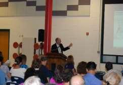
Public Meeting: July 11, 2016
 Public Meeting: July 11, 2016 MONTGOMERY COUNTY PLANNING DEPARTMENT Maryland-National Capital Park and Planning Commission Tonight s Agenda Preliminary Recommendations Background and Context 2009 Twinbrook
MONTGOMERY COUNTY PLANNING DEPARTMENT THE MARYLAND-NATIONAL CAPITAL PARK AND PLANNING COMMISSION
 MONTGOMERY COUNTY PLANNING DEPARTMENT THE MARYLAND-NATIONAL CAPITAL PARK AND PLANNING COMMISSION White Flint 2 Sector Plan: Briefing and Preliminary Staff Recommendations MCPB Item No. Date: 07/28/2016
white flint 2 sector plan
 white flint 2 sector plan Public Hearing Draft NOVEMBER 2016 MONTGOMERY COUNTY PLANNING DEPARTMENT M-NCPPC MontgomeryPlanning.org White Flint 2 Sector Plan Public Hearing Draft Abstract This Plan contains
Rock Spring Master Plan Community Meeting #8: Preliminary Recommendations
 Rock Spring Master Plan Community Meeting #8: Preliminary Recommendations July 18, 2016 Ι Walter Johnson High School Andrea Gilles, andrea.gilles@montgomeryplanning.org Ι www.montgomeryplanning.org/community/rockspring/
S C O P E O F W O R K A P R I L
 white flint 2 sector plan S C O P E O F W O R K A P R I L 2 0 1 2 MONTGOMERY COUNTY PLANNING DEPARTMENT M-NCPPC MontgomeryPlanning.org 1 white flint 2 sector plan Scope of Work abstract This scope of work
Approved and Adopted JANUARY 2018
 Approved and Adopted JANUARY 2018 Abstract This Plan contains the text and supporting maps for a comprehensive amendment to the approved and adopted 1992 North Bethesda/Garrett Park Master Plan and the
Public Forum-Part II: June 20, 2016
 Public Forum-Part II: June 20, 2016 MONTGOMERY COUNTY PLANNING DEPARTMENT Maryland-National Capital Park and Planning Commission Tonight s Agenda I. Schedule and Next Steps II. Presentations i. Abbe Milstein
Rock Spring Master Plan Community Meeting #6: Land Use + Transportation Forecasts
 Rock Spring Master Plan Community Meeting #6: Land Use + Transportation Forecasts May 23, 2016 Ι Walter Johnson High School Andrea Gilles, andrea.gilles@montgomeryplanning.org Ι www.montgomeryplanning.org/community/rockspring/
THE 355/270 CORRIDOR:
 THE 355/270 CORRIDOR: Strategic Ideas for Sustaining a Livable Work Place Project Summary ACCESS LIFE DESIGN HEALTH WORK Montgomery County Planning Department The Maryland-National Capital Park and Planning
Germantown Forward Status Report to the Planning Board M NCPPC
 Germantown Forward Status Report to the Planning Board Germantown Forward March 27, 2008 What s new? CCT alignment Capital Improvement Program Agency partners Water quality conditions Sustainability Design
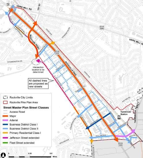
CONTENTS BACKGROUND AND CONTEXT... 3 Plan Area... 3 History... 3 Previous Planning Initiatives... 4 PLANNING FRAMEWORK... 5 Countywide Transit
 CONTENTS BACKGROUND AND CONTEXT... 3 Plan Area... 3 History... 3 Previous Planning Initiatives... 4 PLANNING FRAMEWORK... 5 Countywide Transit Corridors Functional Master Plan... 5 Veirs Mill Road Bus
MONTGOMERY COUNTY PLANNING DEPARTMENT
 MONTGOMERY COUNTY PLANNING DEPARTMENT THE MARYLAND-NATIONAL CAPITAL PARK AND PLANNING COMMISSION 6000 Executive Boulevard, Sketch Plan No. 320180140 MCPB Item No. Date: 06/21/2018 Emily Tettelbaum, Senior
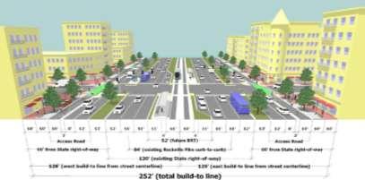
Establish a network of streetscaped vehicle and pedestrian routes that connect within and outside the Plan area.
 This Plan s urban design goals are to create an urban scale, walkable community with connections to transit, parks, and services and with amenities and facilities for residents and employees. The 1992
Status Report: MD 355 Project
 Status Report: MD 355 Project OCTOBER 2006 M-NCPPC MONTGOMERY COUNTY PLANNING DEPARTMENT Summary of Community Comments, and break to the Results of the MD 355 Participation Session Brookside Gardens -
JUSTIFICATION STATEMENT FOR SKETCH PLAN NO Sketch Plan Justification for Wilgus
 JUSTIFICATION STATEMENT FOR SKETCH PLAN NO. 320190070 Sketch Plan Justification for Wilgus I. INTRODUCTION Owner and Applicant, Wilgus-Montrose Associates LLC ( Applicant ), by its attorneys, Linowes and
MONTGOMERY COUNTY PLANNING DEPARTMENT THE MARYLAND-NATIONAL CAPITAL PARK AND PLANNING COMMISSION
 MONTGOMERY COUNTY PLANNING DEPARTMENT THE MARYLAND-NATIONAL CAPITAL PARK AND PLANNING COMMISSION MCPB Item No. Date10/25/12 Sketch Plan No. 32012004, White Flint Mall Redevelopment Nkosi Yearwood, Senior
MONTGOMERY COUNTY PLANNING DEPARTMENT THE MARYLAND-NATIONAL CAPITAL PARK AND PLANNING COMMISSION
 MONTGOMERY COUNTY PLANNING DEPARTMENT THE MARYLAND-NATIONAL CAPITAL PARK AND PLANNING COMMISSION Staff Report: Sketch Plan #320110010, Mid-Pike Plaza ITEM #: MCPB HEARING DATE: January 20, 2011 REPORT
Town Center. Block 5 Existing multifamily residential units are expected to remain.
 Area Guidelines Germantown s districts should be developed as distinct communities with unique features that are supported through the guidelines. The guidelines not only help distinguish these districts
Seneca Meadows. Block 4 Locate office, technology, and medical development adjacent to I Screen views of garage structures from I-270.
 Seneca Meadows Seneca Meadows has an industrial park in its southern end and a mixed-use employment area planned for the north end. The district benefits from extensive I-270 visibility, stream valley
MONTGOMERY COUNTY PLANNING DEPARTMENT THE MARYLAND-NATIONAL CAPITAL PARK AND PLANNING COMMISSION
 MONTGOMERY COUNTY PLANNING DEPARTMENT THE MARYLAND-NATIONAL CAPITAL PARK AND PLANNING COMMISSION MCPB Item No. Date: 09.03.15 White Flint 2 Sector Plan, Scope of Work Nkosi Yearwood, Senior Planner, Area
ELMVALE ACRES SHOPPING CENTRE MASTER PLAN
 ELMVALE ACRES SHOPPING CENTRE MASTER PLAN Contents 1.0 INTRODUCTION... 2 2.0 LOCATION... 2 3.0 EXISTING CONTEXT... 2 4.0 VISION & GUIDING PRINCIPLES... 2 5.0 LAND USE AND BUILT FORM... 4 5.1 St. Laurent
Transportation. Strategies for Action
 Transportation A major priority for the Overlake Neighborhood is to develop a multimodal transportation system. To achieve this system, a balance has to be found among travel, circulation and access needs;
Gold Line Bus Rapid Transit Transit Oriented Development (BRTOD) Helmo Station Area Plan
 Helmo Station Area Plan") Appendix F Gold Line Bus Rapid Transit Transit Oriented Development (BRTOD) Helmo Station Area Plan Introduction and Purpose of the Plan The Gold Line Bus Rapid Transit facility is an eleven-mile dedicated
Appendix F Gold Line Bus Rapid Transit Transit Oriented Development (BRTOD) Helmo Station Area Plan Introduction and Purpose of the Plan The Gold Line Bus Rapid Transit facility is an eleven-mile dedicated
Proposed Comprehensive Plan Strategies DRAFT for discussion June 28, 2017
 Proposed Comprehensive Plan Strategies DRAFT for discussion June 28, 2017 Land Use Rural Areas Refine the Farm and Forest area (FF) Update FF boundaries to account for existing lots less than five acres
Preliminary Recommendations Tk Takoma/Langley Crossroads Sector Plan
 Preliminary Recommendations Tk Takoma/Langley Crossroads Sector Plan Vision is to achieve a Transit Oriented, pedestrian friendly Community that Celebrates and builds upon the cultural Diversity of the
DRAFT Land Use Chapter
 Stevens Creek Urban Village DRAFT 1 18 17 Land Use Chapter INTRODUCTION This Land Use Chapter describes how the Stevens Creek Urban Village will accommodate the growth that is planned for it in the Envision
At first Work Session on October 22, At second Work Session on November 19, At third Work Session on December 3, 2015
 At first Work Session on October 22, 2015 Staff Reviewed Infrastructure: Transportation Capacity School Capacity Willett Branch Proposed Staging Language At second Work Session on November 19, 2015 Land
MONTGOMERY COUNTY METRO STATION AREA DESIGN CHARRETTE
 MONTGOMERY COUNTY METRO STATION AREA DESIGN CHARRETTE Shady Grove Metro Station Area Charrette Closing Presentation October 25-28, 2000 MONTGOMERY COUNTY, MD M-NCPPC Design Collective, Inc. Architects
Westwood Shopping Center Sketch Plan, Plan # February 23, 2017 Item # 9
 Westwood Shopping Center Sketch Plan, Plan # 320170010 February 23, 2017 Item # 9 Westwood II Site 64,111 s.f. Manor Care site: vacant two story building HOC-Westwood Towers, 15 story tower To be considered
MONTGOMERY COUNTY PLANNING DEPARTMENT THE MARYLAND NATIONAL CAPITAL PARK AND PLANNING COMMISSION
 MONTGOMERY COUNTY PLANNING DEPARTMENT THE MARYLAND NATIONAL CAPITAL PARK AND PLANNING COMMISSION Bethesda Downtown Sector Plan, Work Session #1 MCPB Item No. Date: 7-20-15 Leslye Howerton, Planner Coordinator,
Appendix 4 Park, Trail, and Recreation Facilities For more information, call the Park Planning and Stewardship Division at
 Appendix 4 Park, Trail, and Recreation Facilities For more information, call the Park Planning and Stewardship Division at 301-650-4380 montgomery county planning board maryland-national capital park and
SW Ecodistrict A VISION PLAN FOR A MORE SUSTAINABLE FUTURE June 25, 2013
 Urban Land Institute The Past, Present and Future of Sustainable Urbanism in Southwest DC SW Ecodistrict A VISION PLAN FOR A MORE SUSTAINABLE FUTURE June 25, 2013 Study Area The National Mall DOE FAA FAA
DRAFT. October Wheaton. Design Guidelines
 October 2011 DRAFT Wheaton Design Guidelines 2 Draft - Design Guidelines - Wheaton Sector Plan Contents 04 Section 1: Introduction 06 Section 2: Context 08 Section 3: Design Guidelines 09 Goal 1: Create
MONTGOMERY COUNTY PLANNING DEPARTMENT THE MARYLAND-NATIONAL CAPITAL PARK AND PLANNING COMMISSION
 MONTGOMERY COUNTY PLANNING DEPARTMENT THE MARYLAND-NATIONAL CAPITAL PARK AND PLANNING COMMISSION Rock Spring Master Plan: Briefing and Preliminary Staff Recommendations MCPB Item No. Date: 07/28/2016 Andrea
Silverdale Regional Center
 Silverdale Regional Center Vision for Silverdale Regional Center The Silverdale Regional Center Plan (Plan) will guide the evolution of the Silverdale Regional Center from a collection of strip malls and
CHAPTER 1. Ms. Guajardo s Class - Central Elementary CH 1 1
 INTRODUCTION CHAPTER 1 Ms. Guajardo s Class - Central Elementary CH 1 1 1.1 SETTING South Centre City is a linear corridor south of Downtown Escondido paralleling Centre City Parkway and South Escondido
CHAPTER 7: Transportation, Mobility and Circulation
 AGLE AREA COMMUNITY Plan CHAPTER 7 CHAPTER 7: Transportation, Mobility and Circulation Transportation, Mobility and Circulation The purpose of the Transportation, Mobility and Circulation Chapter is to
Subarea 4 Indian Creek. Vision The combination of park networks and transportation amenities make Subarea 4 the greenest hub in the Corridor.
 indian creek 180 extends south from 101st Street to I-435. The I-435 and Metcalf intersection is one of the primary intersections in the Kansas City Metro Area. The area includes several residential neighborhoods
Urban Park Guidelines
 Park Planning & Stewardship Division Park & Trail Planning Section Urban Park Guidelines Objectives, Outreach Strategy Recommendations and Plan Schedule PARK PLANNING & STEWARDSHIP Brooke Farquhar, Rachel
Lehigh Acres Land Development Regulations Community Planning Project
 Lehigh Acres Land Development Regulations Planning Effort Summary In July, 2010 Commissioner Frank Mann invited the Lehigh Acres community to start discussing how to achieve their recently adopted community
Shady Grove Sector Plan
 Montgomery Planning Area 2 Division 11/15/2018 Shady Grove Sector Plan Minor Master Plan Amendment Scope of Work Edit presentation title MM/DD/YYYY 1 Purpose for the Plan Amendment 1. Reevaluate/status
Part 2 Common Elements
 WHITE FLINT SECTOR PLAN Round Table Discussion: Part 2 Common Elements October 8, 2007 The M-NCPPC 1 Role Regional Marketplace North Bethesda s Downtown with a Conference Center District The M-NCPPC 2
June White Flint. Urban Design Guidelines
 June 2010 White Flint Urban Design Guidelines Context Montgomery County s General Plan envisioned urban centers along the I-270 corridor as places where compact, transit serviceable growth and employment
East Central Area Plan
 East Central Area Plan Steering Committee Meeting March 8 th, 2018 CHUN Tears McFarlane House Vision Statement Development Opportunities Analysis Vision Elements 1. Equitable, Affordable and Inclusive
County Council Presentation. White Oak Science Gateway Planning Board Draft Master Plan June 17, 2014
 County Council Presentation White Oak Science Gateway Planning Board Draft Master Plan June 17, 2014 http://montgomeryplanning.org/community/wosg/index.shtm Nancy Sturgeon, Lead Planner www.nancy.sturgeon@montgomeryplanning.org
C. Westerly Creek Village & The Montview Corridor
 C. Westerly Creek Village & The VISION Community Vision When the goals of the city are achieved Westerly Creek Village, a distinctive community defined by Montview Boulevard and Westerly Creek, is a strong
BROOKHILL NEIGHBORHOOD MODEL ZONING MAP AMENDMENT PREFACE TO APPLICATION
 BROOKHILL NEIGHBORHOOD MODEL ZONING MAP AMENDMENT PREFACE TO APPLICATION June 15, 2015 Revised: August 1, 2016 I. VISION Brookhill is a proposed community based upon the principles of Albemarle County
MEMORANDUM BACKGROUND. lcouncilmembers should bring their copy of the Plan to the meeting.i. AGENDA ITEM #l0a November 28, 2017.
 AGENDA ITEM #l0a November 28, 2017 Worksession MEMORANDUM November 22, 2017 TO: FROM: SUBJECT: County Council ~ Marlene Michaelson, Senior Legislative Analyst Grosvenor-Strathmore Metro Area Minor Master
Planning Board Briefing
 Planning Board Briefing Why Now? The Sector Plan Implementation Chapter States: Before Stage 1 begins, the following must occur: Approval of the Sectional Map Amendment. Approval of the Greater Lyttonsville
Secrest Short Cut and Monroe Expressway Small Area Plan AUGUST 29, 2018
 Secrest Short Cut and Monroe Expressway Small Area Plan AUGUST 29, 2018 Background and Process Monroe Expressway will be open by the end of 2018 Union County and Indian Trail identified a need to revisit
BROOKLYN PARK / 85TH AVE LRT STATION CDI DEVELOPMENT GUIDELINES DRAFT
 August 2018 Page intentionally left blank The Brooklyn Park Library adjacent to the 85th Ave LRT Station Area. OVERVIEW The Blue Line LRT Extension / Bottineau corridor offers a unique opportunity to leverage
Atlanta BeltLine. Subareas 9 & 10. Master Plan Updates. March 26, Washington Park Jamboree 1
 Atlanta BeltLine Subareas 9 & 10 Master Plan Updates March 26, 2018 Washington Park Jamboree 1 22 miles, connecting 45 neighborhoods 22 MILES of transit 46 MILES of streetscapes and complete streets 33
White Flint Advisory Group Forum February 27, 2007 Summary M-NCPPC Auditorium 7:00-9:30 P.M.
 White Flint Advisory Group Forum February 27, 2007 Summary M-NCPPC Auditorium 7:00-9:30 P.M. Neighborhood 1 Bob Stoddard, Washington Real Estate Investment Trust Regarding: 12250 Nebel Street and 5520
Isabel Neighborhood Plan: Alternatives
 Isabel Neighborhood Plan: Alternatives Presented by: Lori Parks, Associate Planner February 2, 2015 Agenda 1. Background on BART to Livermore 2. Isabel Neighborhood Plan 3. Alternative Scenarios 4. General
Subregion 4 Central Avenue-Metro Blue Line Corridor Transit-Oriented Development (TOD) Implementation Project. Community Meeting April 27, 2011
 Implementation Project. Community Meeting April 27, 2011") Subregion 4 Central Avenue-Metro Blue Line Corridor Transit-Oriented Development (TOD) Implementation Project Community Meeting April 27, 2011 Overview Introduction to Subregion 4 TOD Implementation Program
Subregion 4 Central Avenue-Metro Blue Line Corridor Transit-Oriented Development (TOD) Implementation Project Community Meeting April 27, 2011 Overview Introduction to Subregion 4 TOD Implementation Program
WHITE FLINT SECTOR PLAN PHASE I PRESENTATION Montgomery County Planning Board April 13, Luxmanor Citizens Association
 WHITE FLINT SECTOR PLAN PHASE I PRESENTATION Montgomery County Planning Board April 13, 2009 Luxmanor Citizens Association An Inclusive Master Plan The Vision of a Better Community Pedestrian oriented
The transportation system in a community is an
 7 TRANSPORTATION The transportation system in a community is an important factor contributing to the quality of life of the residents. Without a sound transportation system to bring both goods and patrons
Long Branch Sector Plan
 June 2012 Long Branch is one of Montgomery County s most affordable, older communities and has served as a gateway community, especially for newly arriving immigrants, since the 1960s. Many within this
Shared Principles and Emerging Plan Directions
 Shared Principles and Emerging Plan Directions Introduction Since the Fairfield Neighbourhood planning process launched in June 2016, we have heard from many residents, businesses, groups and other people
MONTGOMERY COUNTY PLANNING DEPARTMENT THE MARYLAND-NATIONAL CAPITAL PARK AND PLANNING COMMISSION
 MONTGOMERY COUNTY PLANNING DEPARTMENT THE MARYLAND-NATIONAL CAPITAL PARK AND PLANNING COMMISSION MCPB Item No. Date: 1/26/12 Hanover Shady Grove, Sketch Plan 320120020 Joshua Sloan, Coordinator, Joshua.Sloan@MontgomeryPlanning.org,
LEED-ND 101: Practical Strategies for Achieving Sustainability Goals. Travis Parker Lakewood Planning Director
 LEED-ND 101: Practical Strategies for Achieving Sustainability Goals Travis Parker Lakewood Planning Director Metro Vision Idea Exchange Oct 11, 2012 West Corridor Stations West Corridor Overview West
ASPEN HILL Minor Master Plan Amendment
 ASPEN HILL Minor Master Plan Amendment Project Briefing Planning Board Agenda Item #7 Andrea Gilles, Area 2 June 5, 2014 Briefing Purpose 1. Follow-up evaluation on Mixed-Use land use in the Minor Amendment
[PLANNING RATIONALE] For Site Plan Control and Lifting of Holding Zone By-Law 101 Champagne Avenue. May 23, 2014
![[PLANNING RATIONALE] For Site Plan Control and Lifting of Holding Zone By-Law 101 Champagne Avenue. May 23, 2014](/thumbs/75/71599615.jpg "[PLANNING RATIONALE] For Site Plan Control and Lifting of Holding Zone By-Law 101 Champagne Avenue. May 23, 2014") [PLANNING RATIONALE] For Site Plan Control and Lifting of Holding Zone By-Law 101 Champagne Avenue May 23, 2014 Contents 1.0 Introduction... 2 2.0 Site Context... 2 2.1 Adjacent Uses... 2 Figure 1: Site
[PLANNING RATIONALE] For Site Plan Control and Lifting of Holding Zone By-Law 101 Champagne Avenue May 23, 2014 Contents 1.0 Introduction... 2 2.0 Site Context... 2 2.1 Adjacent Uses... 2 Figure 1: Site
Review of Opportunity Area C Draft Comprehensive Plan and Draft BOS Follow-On Motions. Special Working Group Meeting March 4, 2015
 Review of Opportunity Area C Draft Comprehensive Plan and Draft BOS Follow-On Motions Special Working Group Meeting March 4, 2015 The slides that follow identify where the draft Comprehensive Plan has
Obey Creek July 17, Vicinity Map. Concept Plan Submittal. No
 15/501 Fordham Blvd. 15/501 By-Pass To Downtown Chapel Hill Vicinity Map 0 1000 2000 FT Arlen Park DR. Bennett Road Mt. Carmel Church Rd. Southern Village Parkside Circle Market St. 15/501 Founder's Ridge
Northwest Rail Corridor and US 36 BRT Development Oriented Transit Analysis 4.4 STATION AREA FINDINGS
 4.4 STATION AREA FINDINGS Each station is different, and each one requires a separate set of recommendations based on the vision for the site. This section outlines an initial TOD strategy and recommendations
MONTGOMERY COUNTY PLANNING DEPARTMENT
 MONTGOMERY COUNTY PLANNING DEPARTMENT THE MARYLAND-NATIONAL CAPITAL PARK AND PLANNING COMMISSION Ashburton Elementary School Addition, Mandatory Referral, MR2018009 MCPB Item No. Date: 02-15-18 Troy Leftwich,
DRAFT ROOSEVELT ROAD. District Recommendations. Figure 5.23 The Roosevelt Road Corridor
 CHAPTER 5 Figure 5.23 The Road Corridor Road will develop as a mixed-use corridor, emphasizing regional retail, west of the river and mixed-use development east of the river. KEY RECOMMENDATIONS 1. High
Draft Bergamot Area Plan
 ATTACHMENT 1 Draft Bergamot Area Plan Taskforce on the Environment April 15, 2013 www.bergamotplan.net 1 Overview WHAT IS THE BERGAMOT AREA PLAN? A Community-Based Planning Document Guiding the Future
MONTGOMERY COUNTY PLANNING DEPARTMENT THE MARYLAND-NATIONAL CAPITAL PARK AND PLANNING COMMISSION
 MONTGOMERY COUNTY PLANNING DEPARTMENT THE MARYLAND-NATIONAL CAPITAL PARK AND PLANNING COMMISSION MCPB Item No. Date: 05/12/2016 North Bethesda Conference Center Parking Structure, Mandatory Referral No.
The University District envisions, in its neighborhood
 Envisioning the University District Link Light Rail in Seattle s neighborhoods CIY OF SEALE CONCEP-LEVEL SAION AREA PLANNING RECOMMENDAION RESOLUION # 30165 EXHIBI L Vision 08.2000 he University District
Complete Neighbourhood Guidelines Review Tool
 Complete Neighbourhood Guidelines Review Tool Prepared By: City of Regina Planning Department October 2014 Page 1 of 14 Community Development Review Checklist for Secondary Plans and Concept Plans The
Mini Technical Assistance Panel. Rock Spring Park
 Mini Technical Assistance Panel Rock Spring Park May 22, 2013 The Team Jason Bonnet, Forest City Washington Matthew Flis, Town of Vienna William Herbig, National Capital Planning Commission Sophie Lambert,
MONTGOMERY COUNTY PLANNING DEPARTMENT
 MONTGOMERY COUNTY PLANNING DEPARTMENT THE MARYLAND-NATIONAL CAPITAL PARK AND PLANNING COMMISSION MCPB Item No.: Date: 5-03-18 Pike and Rose, Phase I: Site Plan Amendment No. 82012002D Rhoda Hersson-Ringskog,
THE NEIGHBORHOOD TODAY
 THE NEIGHBORHOOD TODAY CORE AREA VISION How are we Good Urbanism A Site s DNA thinking about Elements of great Unique elements urban communities embedded in a place the site and design? ELEMENTS LIKE:
Appendix C: Interim Mixed-Use Evaluation Criteria
 Appendix C: Interim Mixed-Use Evaluation Criteria C-1 Appendix C: Interim Mixed-Use Evaluation Criteria PURPOSE: The implementation of numerous policies contained within the Master Plan hinges on the creation
Today Land & People. Northeast Nampa Gateway District. Employment. Land Use Characteristics. Demographics. Current Zoning
 Today Land & People Employment Major employers include Saint Alphonsus, the College of Western Idaho, the Auto Mall, Sorrento Lactalis and Walmart. 3,004 jobs in 2010 (COMPASS-CIM 2040 TAZ data) 4,345
International Blvd. TOD Plan Public Workshop #1
 International Blvd. TOD Plan Public Workshop #1 Add photos or project images September 21 and 22, 2010 Workshop Purpose Introduce the public to the Project Review and discuss the existing conditions analysis
URBAN DESIGN BRIEF. 2136&2148 Trafalgar Road. Town of Oakville
 URBAN DESIGN BRIEF 2136&2148 Trafalgar Road Town of Oakville Prepared By: METROPOLITAN CONSULTING INC For 2500674 Ontario Inc November 2016 TABLE OF CONTENTS Page No. 1.0 Introduction/Description of Subject
Create Policy Options Draft Plan Plan Approval. Public Consultation Events. Phase 2
 Background Grandview-Woodland Community Plan In the spring of 2012, the City of Vancouver embarked on a comprehensive community planning program in the Grandview-Woodland neighbourhood. The process has
CHARLES PUTMAN CHARLES PUTMAN AND ASSOCIATES, INC
 MEMORANDUM CHARLES PUTMAN & ASSOCIATES, INC. LAND DEVELOPMENT CONSULTANTS PLANNING ZONING PERMITTING 4722 NW Boca Raton Boulevard, Suite C-106 Boca Raton, Florida 33431 Phone: 561/994-6411 FAX: 561/994-0447
public review draft Key objectives for this chapter are:
 5 - parks & open space Providing a rich collection of outdoor places for informal gathering and recreation, as well as planned promotional activities and community events, is a key concept for Midtown.
City of Plantation Midtown District Conceptual Plan Implementation Update. City Council Presentation February 22, 2017
 City of Plantation Midtown District Conceptual Plan Implementation Update City Council Presentation February 22, 2017 Purpose of Presentation The purpose of this presentation is to: 1. Review key concepts
Courthouse Square Planning & Urban Design Study. Courthouse Square Working Group #13 October 15, 2014
 Courthouse Square Planning & Urban Design Study Courthouse Square Working Group #13 October 15, 2014 1 Courthouse Square Process Working Group Community Courthouse Square Advisory Groups & Civic Associations
Rio/29 Small Area Plan. Design Plan & Implementation Framework Open House - January 25, 2018
 Rio/29 Small Area Plan Design Plan & Implementation Framework Open House - January 25, 2018 MEETING PURPOSE PRESENTATION 1. Orient to the updated design plans 2. Introduce implementing options 3. Explain
Implementation Guide Comprehensive Plan City of Allen
 Implementation Guide 2030 Comprehensive Plan City of Allen DRAFT 2015 Implementation Guide Allen 2030 Comprehensive Plan INTRODUCTION The Comprehensive Plan serves as a guide for the growth and development
Community Design Guidelines. Port Wallace DRAFT
 Community Design Guidelines Port Wallace DRAFT Energy 1 2 3 Nature Movement Connections Built Form DRAFT Layout Energy 1 Nature Community Design Guidelines GREAT COMMUNITIES PROTECT, CELEBRATE, AND CONSERVE
APPENDICES DESIGNING PUBLIC SPACES - ENERGIZED PUBLIC SPACES DESIGN GUIDELINES WORKING DRAFT DECEMBER 2018 A1
 APPENDICES DESIGNING PUBLIC SPACES - ENERGIZED PUBLIC SPACES DESIGN GUIDELINES WORKING DRAFT DECEMBER 2018 A1 App.1 Case Studies by Park Types The upcoming (in-progress) online library will house several
2018 Northampton Township Comprehensive Plan
 2018 BUCKS COUNTY, PENNSYLVANIA What is a? A comprehensive plan is a municipality s main policy document that details the collective vision for the future, the historic, environmental, and cultural facilities
Wheaton CBD & Vicinity Sector Plan D E S I G N G U I D E L I N E S
 Wheaton CBD & Vicinity Sector Plan D E S I G N G U I D E L I N E S 1 a b s t r a c t This document contains the design guidelines the property owners, community members, and planners should use to implement
Midtown Greenway Land Use and Development Plan Executive Summary
 Midtown Greenway Land Use and Development Plan Executive Summary Introduction The Midtown Greenway Land Use and Development Plan sets policy direction for land use and development in the Midtown Greenway
Additional information about land use types is given in Chapter 5. Design guidelines for Centers and Neighborhoods are given in Chapter 7.
 4. Place Types Introduction In Albemarle County s Development Areas, the Neighborhood is the fundamental unit of community planning. The County s Neighborhood Model, an adopted part of the Comprehensive
TRANSIT NEIGHBORHOOD PLANS PROGRAM OVERVIEW
 TRANSIT NEIGHBORHOOD PLANS PROGRAM OVERVIEW OCTOBER 2017 Los Angeles Department of City Planning @LATNP and @Planning4LA Outline Introduction Policy Framework The Transit Neighborhood Plans Program Overview:
JUSTIFICATION STATEMENT FOR SKETCH PLAN NO Sketch Plan Justification for Ourisman Ford
 I. INTRODUCTION JUSTIFICATION STATEMENT FOR SKETCH PLAN NO. 320170100 Sketch Plan Justification for Ourisman Ford Owner and Applicant, FP Whitro Westlake, LLC ( Applicant ), by its attorneys, Linowes and
Chapter 1.0 Introduction
 Chapter 1.0 Introduction 1.1 Background The North Metro commuter rail line is part of the RTD FasTracks regional transit system expansion program to build more than 100 miles of rail transit throughout
COURTICE MAIN STREET COMMUNITY IMPROVEMENT PLAN
 COURTICE MAIN STREET COMMUNITY IMPROVEMENT PLAN Public Meeting #1 April 28, 2016 Birdseye view of the study area PIC #1 AGENDA Agenda and Format 6:30 6:50 Registration 6:50 7:45 Introductions, Presentation
A Plan for the Heart of the Region: Tukwila, WA
 : Tukwila, WA 1 The Plan orchestrates the Restructuring of a 1,000-acre Regional Shopping Area into a Social and Symbolic for the Region. REGIONAL CONTEXT Downtown Seattle (Metropolitan ) 20 miles Bellevue
WELCOME and introduction
 1 WELCOME and introduction Mobility Hub Locations within Burlington STUDY OVERVIEW STUDY OBJECTIVES The City of Burlington is developing four Area Specific Plans, one for each of Burlington s Mobility
EXISTING PLANS Harriet Festing Center for Neighborhood Technology Midlothian Community Meeting March 12, 2015
 EXISTING PLANS Harriet Festing Center for Neighborhood Technology Midlothian Community Meeting March 12, 2015 BENEFITS Bring economic, community + environmental benefits Enhance property values Use
Workshop #1 Outcomes. The Planning Partnership
 Workshop #1 Outcomes The Planning Partnership 1 Background Review Planning Provincial Policy Statement Greenbelt Plan Places to Grow: Growth Plan York Region Official Plan York Region Draft Official Plan