Once Upon a Gravel Pit: Reconnecting Floodplain through Aggregate Extraction
|
|
|
- Frederick Norton
- 5 years ago
- Views:
Transcription
1 Once Upon a Gravel Pit: Reconnecting Floodplain through Aggregate Extraction 5 th International Conference on Natural Channel Systems September 26,
2 The Story of Snyder s Flats Historical influences on the site Identifying gravel and proposing a model for environmentally friendly aggregate extraction Restoration beyond the floodplain 25 years later Snyder s Flats Management Plan 2


3 Historical Influences Retreat of the Laurentide Ice Sheet altered the landscape and meltwater channels deposited well-sorted cobbles, gravels and sands Settle in 1807 by Jacob Snyder, gradually cleared and remained mix farming until 1960s

4 Historical Influences Between 1942 and 1976 the GRCA built seven multi-purpose reservoirs for flood damage reduction low-flow augmentation In 1969, the GRCA purchased the flats as part of the K-W Valley Lands Acquisition Program to reduce flooding & erosion risks. 4


5 Identifying the Aggregate Resource Beginning in 1979, the GRCA worked with Preston Sand & Gravel to extract gravel with the vision of modeling an environmentally friendly approach Extensive below the water table resources confirmed in 1987 creating an opportunity to prepare a site plan for enhancing local aquatic and wildlife habitats 5

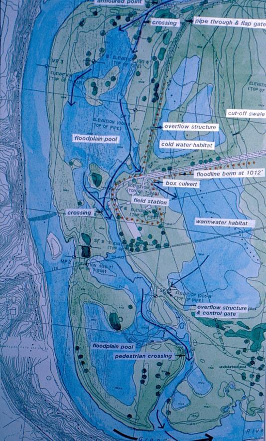
6 The Design Concept 6

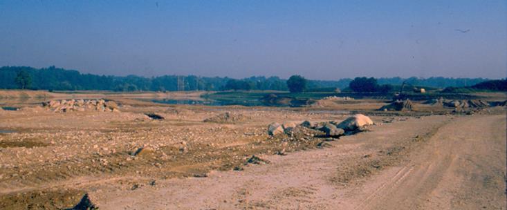
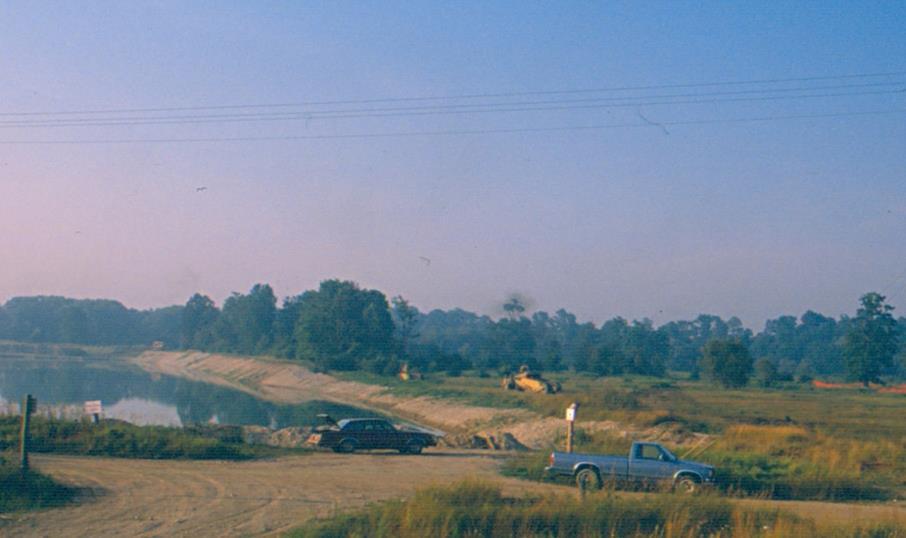
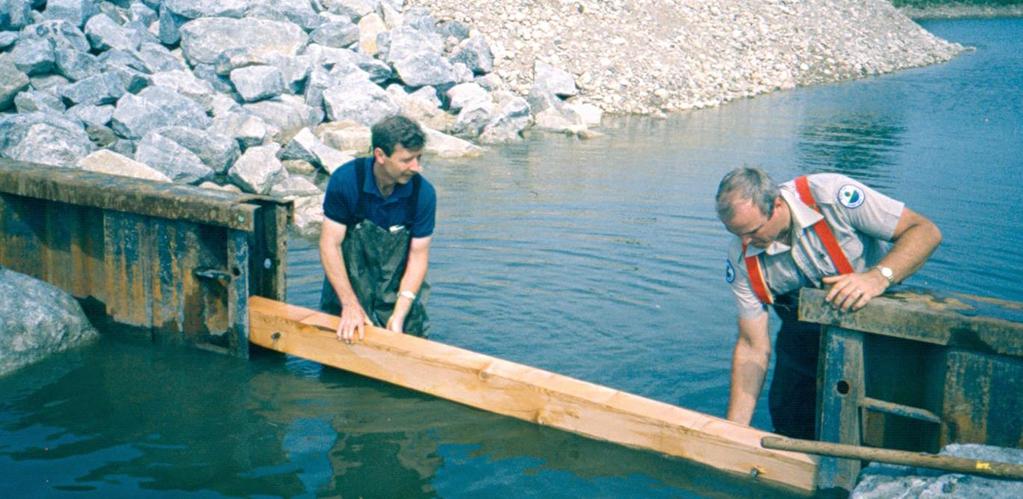
7 The Big Dig ( ) 7

8 The Big Dig ( ) 8
9 Reconnecting the Floodplain 9

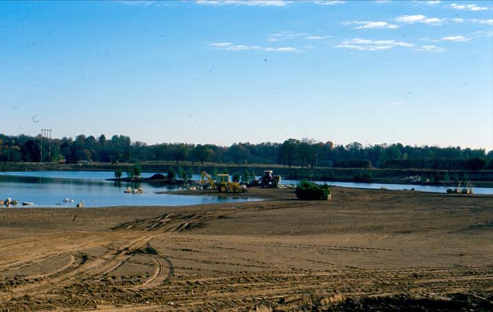
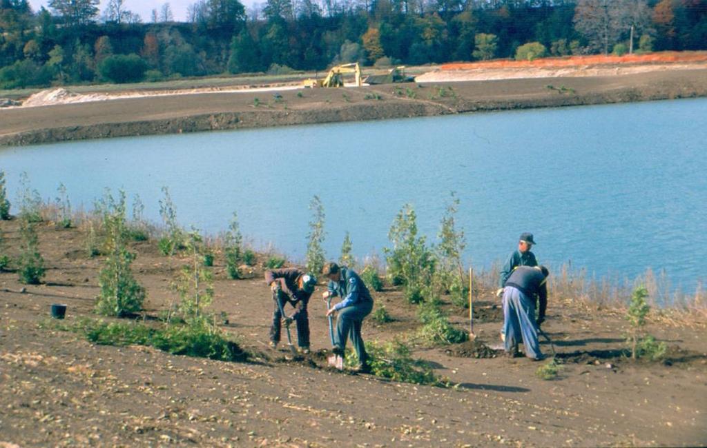
10 The Early Years ( ) 10

11 The Early Years ( ) 11


12 Snyder s Flats Present Day The Warmwater Habitat 9.6 hectares (23.7 acres) 1,640m (5,380ft) of shoreline 12 Pond depths range between 0.2m to 7m providing spawning and nursery habitat
 Pond depths range between 0.")

13 Snyder s Flats Present Day The Coolwater Habitat 3.6 hectares (8.9 acres) Pond depths range between 0.6m to 6m Design includes vegetated finger projections to minimize thermal mixing caused by wind gusts 1,120 meters (3,670 feet) of shoreline 13


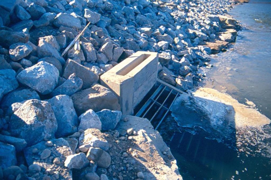
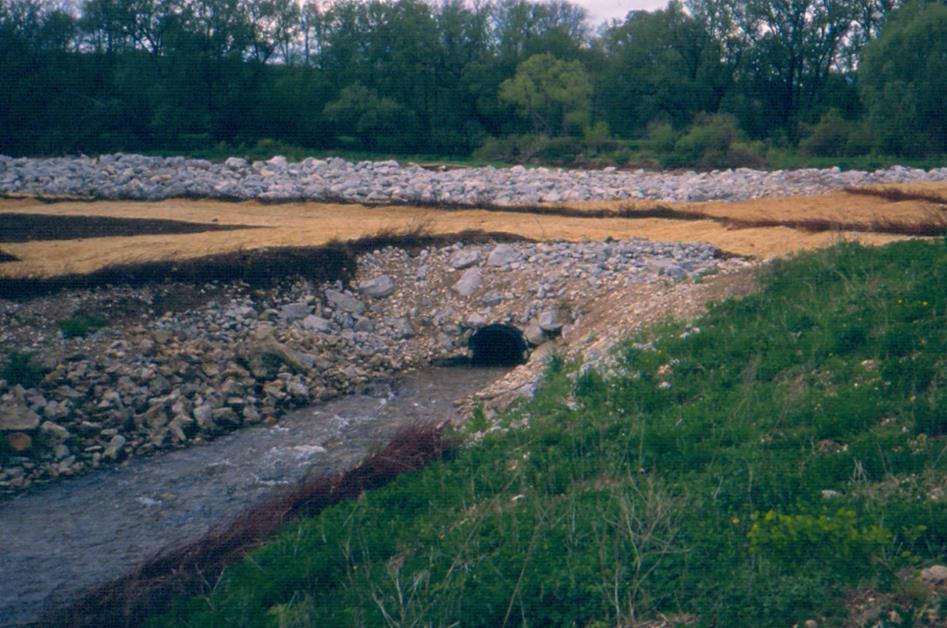
14 Snyder s Flats Present Day North Flood Plain Pool 3.8ha(9.4 acres) & 1,620m(5,320ft) of shoreline Flood Plain Pools & Connecting Channel The Connecting Channel 530m (1,740ft) Riffles oxygenate water and contribute to sustaining aquatic life 14

15 Restoration Beyond the Floodplain Year 1, ,000 trees planted -1 st Kiosk -Project launch Year 2, ,000 trees planted -Prescribed burn & seeding -Trail design & construction -Installation 2 nd kiosk and benches Year 3, ,100 trees planted -2,500 trees replanted -5,000 trees tended -Trail upgrades continued -Interpretive signage -Ongoing monitoring Invasive plant control -Trail maintenance - Tree Maintenance & Tending - Adaptive infill tree planting - Approx trees/year 15
16 Management Plan update In response to growing public recreational usage of the property, an update to the Snyder s Flats Conservation Area Management Plan was completed in 2015 Restoration objectives were reviewed and the following monitoring was carried out: Fisheries surveys Breeding bird surveys Amphibian surveys Incidental Wildlife Observations Completion of ELC mapping for vegetation communities Summarize 25 years of restoration efforts 16
17 Historical Fisheries 1966: Biological Survey of the Grand River and its Tributaries identifies 8 species of fish in the Grand River in the vicinity of Snyder s Flats 1988: 8 species of fish identified Extraction of gravel and development of ponds : over 5 years a total of 26 species of fish identified in the new aquatic habitat features 17


18 Fisheries Results in 2015 Fisheries monitoring confirmed 33 species of fish including Silver Shiner a provincially threatened species at risk 18
19 Was it a Happy Ending? From farmland to aggregate pit to valuable wildlife habitats evolved into diverse ecological landscape Demonstrated environmentally friendly approach to gravel extraction 92 hectares of passive recreation area Creation of 17 hectares of pond & floodplain habitat 1000 s of trees planted and early succession transition habitat establishing Generated approximately $2.4 M 19
20 To Learn More Snyder s Flats Management Plan is available online at GRCA Natural Heritage department, Crystal Allan callan@grandriver.ca Visit the conservation area access via Snyder s Flats Rd near the village of Bloomingdale 20
One River Environmental Assessment. Welcome!
 One River Environmental Assessment Welcome! One River Environmental Assessment Welcome to the One River Environmental Assessment Public Information Centre. Please explore each presentation area to learn
The Napa River Flood Protection Project
 The Napa River Flood Protection Project Creating Flood Protection and Restoring Geomorphic and Biological Processes Jeremy Sarrow, Napa County Flood Control & Water Conservation District June 2, 2014.
Kootenai River Habitat Restoration Program June 18, 2018 Kootenai Valley Resource Initiative Update
 Kootenai River Habitat Restoration Program June 18, 2018 Kootenai Valley Resource Initiative Update Kootenai River Habitat Restoration Program Multi-year habitat restoration program Restoration treatments
New Brighton Park Shoreline Habitat Restoration Project
 Vancouver Board of Parks and Recreation and Port Metro Vancouver New Brighton Park Shoreline Habitat Restoration Project Conceptual Design Public Consultation August 26 September 9, 2015 Discussion Paper
BASS PONDS, MARSH, & WETLAND HABITAT RESTORATION PROJECT
 FACT SHEET BASS PONDS, MARSH, & WETLAND HABITAT RESTORATION PROJECT MINNESOTA VALLEY NATIONAL WILDLIFE REFUGE, MINNESOTA ENVIRONMENTAL MANAGEMENT PROGRAM LOCATION Three areas located on the Minnesota Valley
The Planning Partnership Baird + Associates TCI Management Consultants Ltd. Plan B Natural Heritage Wills Consulting Engineers Poulos & Chung Limited
 Little Lake Master Plan The Planning Partnership Baird + Associates TCI Management Consultants Ltd. Plan B Natural Heritage Wills Consulting Engineers Poulos & Chung Limited May 26, 2009 Purpose of Study
The scope of the plan will focus on the Prospect Heights Slough and Hillcrest Lake as one entity.
 Plan for Prospect Heights Natural Resources Commission Plan for Improved Public Access and Enjoyment of the Prospect Heights Slough and Hillcrest Lake July 23, 2018 The City Council has requested the Natural
Brockholes Wetland and Woodland Nature Reserve, Preston Lancashire
 Newlands Brockholes Wetland and Woodland Nature Reserve, Preston Lancashire Nature s Gateway to Lancashire NEWLANDS Brockholes: site profile Brockholes Wetland and Woodland Nature Reserve project area
RECOMMENDATIONS. Design Recommendations
 RECOMMENDATIONS While the San Diego River Park will serve to unify the river as a whole, each reach of the river park maintains distinct resources and character. Recommendations for each reach have been
BREEDON NORTHERN LIMITED
 Non Technical Summary CONTENTS 1 INTRODUCTION... 1 2 SITE DESCRIPTION... 1 3 DESCRIPTION OF THE DEVELOPMENT... 6 4 NEED FOR THE DEVELOPMENT... 8 5 KEY ISSUES CONSIDERED IN THE ENVIRONMENTAL IMPACT ASSESSMENT...
INTRODUCTION Key Issues and Findings Goals, Objectives, and Policies - Natural Resources - Map M18 - Environmental Resources
 Natural, Environmental, Cu INTRODUCTION This Element provides policies related to the preservation and protection of the Centre Region s natural, environmental, cultural, and historic resources. This Element
Rain Gardens. A Welcome Addition to Your Landscape
 Rain Gardens A Welcome Addition to Your Landscape Where Does The Rainwater Go? Naturally, forests provide a way for rainwater to percolate into the soil, filtering pollutants while trees are allowed to
AT THE HEART OF LAND & WATER MANAGEMENT ON TWEED. tweedforum.org
 AT THE HEART OF LAND & WATER MANAGEMENT ON TWEED Why do we exist? The Tweed is one of the region s greatest assets. It provides a focal point for our natural, built and cultural heritage and a multitude
Improving Communities Through the Arroyo Seco Sustainability Campaign and Watershed Assessment
 Improving Communities Through the Arroyo Seco Sustainability Campaign and Watershed Assessment Arroyo Seco Headwaters in the San Gabriel Mountains Major tributary to the Los Angeles River 44 square mile
A Field Guide to Common Aquatic Plants of Pennsylvania
 A Field Guide to Common Aquatic Plants of Pennsylvania College of Agricultural Sciences CONTENTS Introduction... 2 Algae... 8 Emergent... 20 Submerged... 48 Floating... 82 Index... 102 INTRODUCTION Pennsylvania
North Branch of Cypress Creek Ecological Restoration: A Comprehensive Approach to Stream Restoration
 North Branch of Cypress Creek Ecological Restoration: A Comprehensive Approach to Stream Restoration Rocky Powell Clear Creeks Consulting, LLC Keith D. Tate, P.E. BayLand Consultants & Designers, Inc.
Santa Cruz River Master Plan. Presented to the Arizona Floodplain Management Association Spring Conference June 8-10, 2011
 Santa Cruz River Master Plan Presented to the Arizona Floodplain Management Association Spring Conference June 8-10, 2011 Introduction Who is FICO? 2 Project Team Kimley-Horn and Associates, Inc. River
Terra Nova Rural Park Plan
 Terra Nova Rural Park Plan Part 1 Getting to know the land The Surrounding Area North Side Airport, River, Trail East Side - Residential West Side- Sturgeon Banks, West Dyke Trail South Side:Terra Nova
5 TH ANNUAL CAPE COASTAL CONFERENCE COONAMESSETT RIVER RESTORATION PROJECT. Elizabeth H. Gladfelter, Ph.D. Conservation Commission Town of Falmouth
 5 TH ANNUAL CAPE COASTAL CONFERENCE COONAMESSETT RIVER RESTORATION PROJECT Elizabeth H. Gladfelter, Ph.D. Conservation Commission Town of Falmouth Mural by Teaticket Elementary School 2 nd graders, Spring
A Master Plan for High Park s Hillside Garden and other Ornamental Gardens: Recommendations from the High Park Natural Environment Committee
 www.highparknature.org mail@highparknature.org A Master Plan for High Park s Hillside Garden and other Ornamental Gardens: Recommendations from the High Park Natural Environment Committee September 2015
McArthur Swamp Planning Unit. Fish, Plant, and Wildlife Habitat MCARTHUR SWAMP PLANNING UNIT
 McArthur Swamp Planning Unit Fish, Plant, and Wildlife Habitat Conduct surveys of the planning unit to identify biological resources and enable their protection. Most of the McArthur Swamp land acreage
Pike River Restoration Adaptive Design: Restoring Structure and Function in an Urban Floodplain - from cabbages to cordgrass
 Pike River Restoration Adaptive Design: Restoring Structure and Function in an Urban Floodplain - from cabbages to cordgrass Alice Thompson, PWS & Heather Patti, PWS Pike River Re-imaginedfrom Cabbage
April 11, 2016 Park Board Chair and Commissioners General Manager Vancouver Board of Parks and Recreation New Brighton Salt Marsh - Preferred Concept
 TO: FROM: SUBJECT: April 11, 2016 Park Board Chair and Commissioners General Manager Vancouver Board of Parks and Recreation New Brighton Salt Marsh - Preferred Concept RECOMMENDATION A. THAT the Vancouver
Phase 1 Habitat Replacement & Reconstruction
 Phase 1 Habitat Replacement & Reconstruction Marc Greenberg, USEPA greenberg.marc@epa.gov Hudson River EPA s Expectation of Habitat Reconstruction & Replacement provides diverse habitats Plants, plankton,
ITA and Vicinity Master Plan Update
 1 ITA and Vicinity Master Plan Update PHASE 3 SEPTEMBER 27, 2017 Three Phase Process 2 Phase 1 - Understanding October 13th Public Meeting Phase 2A - Exploring Ideas November 17th Public Meeting Phase
MAYFIELD WEST SECONDARY PLAN PHASE 2
 MAYFIELD WEST SECONDARY PLAN PHASE 2 Public Open House #3 February 25, 2010 Draft Preferred Land Use Scenario TOWN OF CALEDON PLANNING & DEVELOPMENT DEPARTMENT Open House Agenda TOWN OF CALEDON 1. Welcome
Woodland Conservation and the Master Plan
 1 WHAT IS A MASTER PLAN? A Vision for the Future of Your Community Woodland Conservation and the Master Plan Goals Objectives Strategies 2 How Will Your Community Look? TREE PRESERVATION AND THE MASTER
Albion Hills Conservation Area Master Plan. Public Information Session
 Albion Hills Conservation Area Master Plan Public Information Session 1 03.25.2014 Meeting Agenda 1. Project Introduction Property History Current Use Master Plan Process 2. Draft Vision Goals and Objectives
Stream Corridor Management Plan
 Stream Corridor Management Plan A unified and comprehensive approach to protecting, restoring and managing the Upper Delaware River Graydon Dutcher Delaware County Soil and Water Conservation District
ANDERSON RIVER PARK SIDE CHANNEL HABITAT RESTORATION PROJECT. Public Outreach Meeting June 5, 2017
 ANDERSON RIVER PARK SIDE CHANNEL HABITAT RESTORATION PROJECT Public Outreach Meeting June 5, 2017 Welcome and Introductions Providing Feedback Anderson River Park is an important part of the community
Rogue River Recreation and Access Management Plan- Table Rocks Reach. Jackson County, Oregon Department of Fish and Wildlife, National Park Service
 Rogue River Recreation and Access Management Plan- Table Rocks Reach Jackson County, Oregon Department of Fish and Wildlife, National Park Service Today s Agenda Welcome Project refresher Project status/timeline
PART IV - LAND USE POLICIES - RURAL PLANNING AREA
 PART IV - LAND USE POLICIES - RURAL PLANNING AREA 1.0 INTRODUCTION *D9 This part of the Plan presents the principles, objectives and policies for the land use designations identified on the Settlement
Baselands Trails Master Plan Public Meeting. April 28, 2015 Fire Academy, 895 Eastern Avenue, Toronto 6:30 p.m. to 9:00 p.m.
 Baselands Trails Master Plan Public Meeting April 28, 2015 Fire Academy, 895 Eastern Avenue, Toronto 6:30 p.m. to 9:00 p.m. Baselands Trails Master Plan Meeting Purpose To present and get feedback on:
Mississauga Waterfront. Parks Strategy - Draft
 Potential configuration for river s edge seating. Boating on Credit River: A regatta Boating on Credit River: Active enjoyment 5.2 Port Credit Memorial Park West Priority Park 5.2.1 Site Opportunities
An Ambitious Plan: Transforming the blighted South Platte River and surrounding environment into Denver s greatest natural resource.
 CONNECTING THE PEOPLE TO THEIR RIVER SOUTH PLATTE RIVER VISION IMPLEMENTATION PROGRAM: GRANT-FRONTIER PARK TO OVERLAND POND PARK REACH The South Platte River Vision Implementation Program (River Vision)
Increasing Storm Resiliency in Urban Areas Through Ecological Restoration and Design
 Increasing Storm Resiliency in Urban Areas Through Ecological Restoration and Design Rutgers Cooperative Extension Brooke Maslo, Ph.D. Wildlife Extension Specialist Jeremiah Bergstrom, LLA Senior Project
Los Angeles River-Arroyo Seco Confluence Restoration Vision Plan. Professor Meredith McKenzie, JD Urban & Regional Planning Dept Cal Poly Pomona
 Los Angeles River-Arroyo Seco Confluence Restoration Vision Plan Professor Meredith McKenzie, JD Urban & Regional Planning Dept Cal Poly Pomona The Los Angeles River Watershed Arroyo Seco Watershed Map
July 9, Adèle Labbé Environmental Planner City of Guelph 1 Carden Street Guelph, Ontario N1H 3A1. Dear Ms. Labbé.
 July 9, 2014 Adèle Labbé Environmental Planner City of Guelph 1 Carden Street Guelph, Ontario N1H 3A1 Dear Ms. Labbé. Re: 132 Clair Road West EIS Terms of Reference North-South Environmental Inc. (hereafter,
Bigger Better and. Giving nature a home in the Trent Valley: Newark to South Clifton Concept Plan
 Bigger Better and Giving nature a home in the Trent Valley: Newark to South Clifton Concept Plan Our 2050 vision Objectives The Trent and Tame River Valleys will once again be one of the great British
THE CORPORATION OF THE CITY OF WINDSOR Office of the City Solicitor Planning Department
 THE CORPORATION OF THE CITY OF WINDSOR Office of the City Solicitor Planning Department REPORT TO THE CITY OF WINDSOR PLANNING ADVISORY COMMITTEE DATE OF REPORT: August 19, 2010 SUBJECT: Official Plan
Regional Context Statement
 Regional Context Statement REGIONAL CONTEXT STATEMENT 3. REGIONAL CONTEXT STATEMENT In 1995, the Provincial Government passed into law the Growth Strategies Act. The purpose of this provincial initiative
Planning Commission Retreat March 23 rd Comprehensive Plan Update Discussion
 Planning Commission Retreat March 23 rd 2011 Comprehensive Plan Update Discussion Purpose of This Discussion Go Over Key Aspects of the Update Discuss Element By Element Key Concepts Big Ideas What Policies
The Mystic River Greenway
 The Mystic River Greenway City of Medford November 30, 2006 MIT Department of Urban Studies and Planning The Mystic River Greenway A greenway is a regional network that connects: Open Space Visibility,
Baylands Segment J. Bay between the Golden Gate and Segment J. Coyote Point. of For managed ponds. included habitat enhancement.
 Baylands Segment J Crissy Field Alameda Naval Air Station Heron's Head Park COLMA CREEK SFO Millbrae San Mateo BAYLANDS 2009 SAN FRANCISCO AREA san francisco area Western side of central San Francisco
Pine Flat Lake Master Plan Update FACT SHEET September 2014
 Pine Flat Lake Master Plan Update FACT SHEET September 2014 PURPOSE AND OBJECTIVE The U.S. Army Corps of Engineers Sacramento District is revising the 1976 Pine Flat Lake Master Plan and is seeking public
Summary of Changes in the DRAFT Rivers Project Natural Resource Master Plan from the 2001 approved plan to 2014 plan
 Summary of Changes in the DRAFT Rivers Project Natural Resource Master Plan from the 2001 approved plan to 2014 plan The entire Master Plan format and layout has been changed to comply with regulation
Farmers Investment Co. (FICO) Continental Farms
 Continental Farms") Farmers Investment Co. (FICO) Continental Farms Planning & Zoning Commission Study Session (River Master Plan) January 25, 2012 FICO Property 7,000 acres total area 6,000 acres in Town of Sahuarita 1,000
Farmers Investment Co. (FICO) Continental Farms Planning & Zoning Commission Study Session (River Master Plan) January 25, 2012 FICO Property 7,000 acres total area 6,000 acres in Town of Sahuarita 1,000
SECTION 5: REACH RECOMMENDATIONS/MAPS
 SECTION 5: REACH RECOMMENDATIONS/MAPS This section describes areas of concern and provides specific recommendations for each project reach. Locations of stormwater drains were from GIS coverage supplied
6 PORT SYDNEY SETTLEMENT AREA
 Section 6 Port Sydney Page 61 6 PORT SYDNEY SETTLEMENT AREA 6.1 Basis and Principles Village of Port Sydney Waterfront Community Existing Services 6.1.1 Port Sydney is an historic settlement that has developed
WILLAMETTE FALLS LEGACY PROJECT
 OPPORTUNITIES & CONSTRAINTS There are here three falls on a line of rocks extending across the river, which forms the bed of the upper channel. The water is precipitated through deep abrazed gorges, and
Municipal Plan*Assessment
 Municipal Plan*Assessment This tool was developed to assist in reviewing municipal master plans and in determining if these plans are consistent with smart growth principles, neighboring municipal plans,
Community Conservation Workshop. Lake Placid
 Community Conservation Workshop Lake Placid 2 Community Conservation Program Welcome! We have designed a Community Conservation Program that listens to the needs of community members. We are conducting
San Joaquin River Restoration Program Mendota Pool Bypass and Reach 2B Improvements Project. Restoration Goal Technical Feedback Group
 San Joaquin River Restoration Program Mendota Pool Bypass and Reach 2B Improvements Project Restoration Goal Technical Feedback Group March 20, 2014 1:30 pm San Luis and Delta-Mendota Water Authority 842
PICTURE CANYON Planning Riparian-Wetland Refugia in an Urban Setting
 PICTURE CANYON Planning Riparian-Wetland Refugia in an Urban Setting Rio De Flag Existing Conditions. Ephemeral stream; Limited riparian plants, habitats.. & Opportunities Water (effluent) available Restore
CONSERVATION ELEMENT GOALS, OBJECTIVES, AND POLICIES
 CONSERVATION ELEMENT GOALS, OBJECTIVES, AND POLICIES Goal 4 To conserve, manage, appropriately use and protect the natural resources of the City ensuring continued resource availability and environmental
VALLEY VIEW POND Q&A. This item will be discussed under the First Reading portion of the agenda at the July 17, 2012 Village Council meeting.
 VALLEY VIEW POND Q&A This item will be discussed under the First Reading portion of the agenda at the July 17, 2012 Village Council meeting. 1. Please provide a history of the pond including Village maintenance
RECREATION, OPEN SPACE AND GREENWAYS ELEMENT GOALS, OBJECTIVES, AND POLICIES
 RECREATION, OPEN SPACE AND GREENWAYS ELEMENT GOALS, OBJECTIVES, AND POLICIES GOAL R-1: DEVELOP A RECREATION, OPEN SPACE AND GREENWAYS SYSTEM AS AN INTEGRAL COMPONENT OF AN OVERALL, COUNTY-WIDE ECONOMIC
Appendix E Preliminary Design
 Appendix E Preliminary Design 1 1 0+080 0+100 0+200 0+240 LEGEND PROPOSED POOL PROPOSED RIFFLE PROPOSED COIR CLOTH BANK TREATMENT PROPOSED VEGETATED STONE BANK TREATMENT PROPOSED VEGETATED BLOCK BANK TREATMENT
Appendix N. Preliminary Design
 Appendix N Preliminary Design Belfountain Dam and Headpond Class EA Preferred Alternative D4H5: Lower the spillway & backfill headpond & construct channel Preliminary Cost Estimate ITEM ITEM UNIT EST.
Memorial Park Workshop Notes March 20, :30 10:30am
 Memorial Park Workshop Notes March 20, 2012 7:30 10:30am Black Team Veronica, Jeff, Shelly, Pat, Darcey, Gordy, Jeff Strengths River Size/Space Central Location History River Riffles in River View from/going
S A C R A M E N T O C O U N T Y JACKSON HIGHWAY & GRANT LINE EAST VISIONING STUDY
 JACKSON HIGHWAY & GRANT LINE EAST S A C R A M E N T O C O U N T Y P L A N N I N G D E P A R T M E N T SUMMARY AND WORKBOOK November 19, 2008 History of the Visioning Study Sacramento County has two growth
THE SPATIAL PLAN AND THE LANDSCAPE IN CZECH REPUBLIC
 THE SPATIAL PLAN AND THE LANDSCAPE IN CZECH REPUBLIC 13th ELC Conference, 2 3 October, Cetnjie, Montenegro Ing. Igor Kyselka CSc., Institute for spatial development, Jakubské náměstí 3, 60200 Brno, tel.:
MASTER PLAN for the EARL NEWHOUSE WATERFRONT
 MASTER PLAN for the EARL NEWHOUSE WATERFRONT on RESERVOIR POND - CANTON, MA Community Meeting #2 - Thursday, January 11 th PROJECT INTRODUCTION Project Goals: To prepare a MASTER PLAN which develops the
Guide to Naturalizing a Lakefront Shoreline. September 2010
 Guide to Naturalizing a Lakefront Shoreline September 2010 Retaining walls and non-vegetated shorelines are a very common sight on shore-line properties in Alberta. These urbanized shorelines have a huge
APPENDIX F: EXTERNAL APPROVALS
 1.0 RESPONSIBILITIES When the City is constructing the Park or Open Space Development lands (OPTION I), after the subdivision construction process is completed by the Developer, Open Space Development
Lake Nokomis Shoreline Enhancement Project
 Lake Nokomis Shoreline Enhancement Project Community Meeting 2 February 13, 2018 Agenda Current Problems Project Goals Project Status Existing Conditions Community Input Draft Schematic Design Long-term
Caledon Villas Corp. c/o Mr. John Spina 55 Blue Willow Drive Woodbridge, ON L4L 9E8 May 14, Floodplain Characteristics, Old Church Road
 Caledon Villas Corp. c/o Mr. John Spina 55 Blue Willow Drive Woodbridge, ON L4L 9E8 May 14, 2013 Re: Floodplain Characteristics, Old Church Road This letter serves to confirm that I, Linda Sober, have
Town of Peru Comprehensive Plan Executive Summary
 Town of Peru Comprehensive Plan Executive Communities that plan grow by choice, not by chance. A plan makes growth thoughtful, understandable, and predictable. A plan shows that a community is managing
Constructed Stormwater Wetlands
 Types: Shallow Marsh System, Basin/Wetland System, Extended Detention Wetland, Pocket Wetland F. X. Browne, Inc., Lansdale, PA http://www.fxbrowne.com/html/fxb%20wetland%20cs/fxbi_constructed%20wetland_cs.htm
San Diego River Coalition 2012 Work Plan
 San Diego River Coalition 2012 Work Plan Adopted November 18, 2011 The mission of the San Diego River Coalition is preserve and enhance the San Diego River, its watershed, and its natural, cultural and
PEOPLE, WATER, AND WILDLIFE: BLUE PRINCIPLES FOR RIVER DESIGN
 PEOPLE, WATER, AND WILDLIFE: BLUE PRINCIPLES FOR RIVER DESIGN Category One: People Protecting and Enhancing the Quality of Life Role of the Chicago River People and the River For many, the connection between
7.0 SOCIAL, ECONOMIC, AND ENVIRONMENTAL ISSUES
 7.0 SOCIAL, ECONOMIC, AND ENVIRONMENTAL ISSUES The following list of social, economic, and environmental issues have been identified based on a preliminary inventory of resources in the project area, an
Master Plan for Preservation and Scenic Conservation (1995)
") 3.2 Master Plan for Preservation and Scenic Conservation (1995) The Master Plan for Preservation and Scenic Conservation was developed under the direction of the Guilford Preservation Alliance in the 1980s
3.2 Master Plan for Preservation and Scenic Conservation (1995) The Master Plan for Preservation and Scenic Conservation was developed under the direction of the Guilford Preservation Alliance in the 1980s
Community Conservation Workshop. Saranac River Basin Communities
 Community Conservation Workshop Saranac River Basin Communities 2 Community Conservation Program Welcome! We have designed a Community Conservation Program that listens to the needs of community members.
Ashbridges Bay Erosion and Sediment Control Project
 Ashbridges Bay Erosion and Sediment Control Project Project Brief Overview Toronto and Region Conservation Authority, in partnership with the City of Toronto, intends to carry out remedial erosion control
Central Lake Ontario Conservation Conservation Lands Master Plan
 Conservation Lands Master Plan Top 13 Frequently Asked Questions 1. What are conservation lands? Where are these conservation lands located in the Central Lake Ontario Conservation watershed? Conservation
Minto-Brown Island. November 18, City of Salem, Parks & Transportation Services
 Minto-Brown Island Park Master Plan Public Meeting #1 November 18, 2014 City of Salem, Parks & Transportation Services Division, i i Public Works Welcome... and thanks for participating in the master planning
City of Nogales General Plan
 Open Space, Parks, Recreation and Trails City of Nogales General Plan Residents of Nogales place a high priority in the development of a comprehensive system of open space, parks, recreation and trails
1.0 Background. 1.1 Study Process
 1.0 Background Planning for Terwillegar Park began in 2005 with the preparation of A Vision for Terwillegar Park (Randall Conrad & Associates), a City wide public consultation and visioning exercise. The
Construction Progress Report
 Report Date: 4/8/2017 Subject: Construction Week 2 70% Complete Project: Sunset Pond EWP Stream Reclamation, Fourmile Creek, Boulder County, CO Report By: TJ Burr, Civil Engineer/Stream Restoration Specialist,
Module 1 ~ Silent Invaders (MS/HS) Emersed Plants Reading Activity
 Emersed Plants Reading Activity") Name: Class Period: Date: Directions: Read the passage and use the information you ve learned to answer the questions below using complete sentences. Emersed plants are rooted in shallow water with much
Name: Class Period: Date: Directions: Read the passage and use the information you ve learned to answer the questions below using complete sentences. Emersed plants are rooted in shallow water with much
Rule D Wetland and Creek Buffers
 Rule D Wetland and Creek Buffers 1 Policy It is the policy of the Board of Managers to ensure the preservation of the natural resources, recreational, habitat, water treatment and water storage functions
Lake and Stream Restoration Project
 Pre-project Fact Sheet May 2012 Toledo Botanical Garden (TBG) is a 60 acre public garden visited by more than 120,000 people annually. It is located in Toledo, Ohio in the Ottawa River watershed within
A Vision for Walnut Creek
 A Vision for Walnut Creek Photo: City of Clive Walnut Creek Booklet 8 of 8 Greater Des Moines Water Trails and Greenways 1 Table of Contents Booklet 1: Water Trails Strategies and Policies Booklet 2: Beaver
The following principles guide the development of goals and strategies to protect and promote these amenities:
 OPEN SPACE/PARKS/TRAILS/RECREATION GOALS/STRATEGIES Cherry Hills Village is a living environment that offers low density development, open areas, public scenic vistas, public trails and public parks. This
Objective: Resolution to recommend adoption of the Big Thompson Assessment to the Planning Commission
 Type of Meeting: Administrative Matters Name of requestor: Zac Wiebe - 619-4534, Kerri Rollins - 619-4577, Gary Buffington - 619-4560 Department: Natural Resources Preferred appearance date: 8/18/2015
Figure 1. Proposed Strategic Habitat Conservation Areas for Florida
 Figure 1. Proposed Strategic Habitat Conservation Areas for Florida Critical Lands and Waters Identification Project (CLIP) Cooperative Effort Century Commission for Sustainable Florida Florida Natural
Peoria Riverfront Development (Ecosystem Restoration) Upper Mid-sized Island Critical Restoration Project (September 2011)
 Upper Mid-sized Island Critical Restoration Project (September 2011)") Peoria Riverfront Development (Ecosystem Restoration) Upper Mid-sized Island Critical Restoration Project (September 2011) Description The Corps of Engineers, Rock Island District (District) and the Illinois
Peoria Riverfront Development (Ecosystem Restoration) Upper Mid-sized Island Critical Restoration Project (September 2011) Description The Corps of Engineers, Rock Island District (District) and the Illinois
7. Biodiversity & Conservation Areas
 7. & Conservation Areas 7.1. Objectives The objectives of biodiversity and conservation areas are founded on the need to recognise the importance of biodiversity and acknowledge the need to protect, restore
13. VANDORF-PRESTON LAKE SECONDARY PLAN 13.1 INTRODUCTION
 13. VANDORF-PRESTON LAKE SECONDARY PLAN 13.1.1 Purpose 13.1 INTRODUCTION The Vandorf-Preston Lake Secondary Plan establishes the principles, objectives and general policies, as well as specific strategies
Forest Grove Park Master Plan
 Workshop 03 Steering Committee Meeting 2:00 5:00 PM Public Open House 5:00 7:00 PM February 21, 2012 Agenda February 21, 2012 Schedule and planning process update. Preliminary Program review. Concept plan
Restoration in the Sky Islands:
 Restoration in the Sky Islands: Bringing volunteers, landowners, practitioners and agencies together to benefit wildlife and habitats in a global biodiversity hotspot Sky Island Alliance Dedicated to the
Glenborough at Easton Land Use Master Plan
 Land Use Framework November 30, 2007 2.0 LAND USE FRAME- WORK 2.1 LAND USE HISTORY and Setting Glenborough at Easton is located on property that was used for mining in the 19th and 20th centuries and rocket
Slough International Freight Exchange Proposals, Colnbrook+
 Welcome Welcome to this exhibition, which is being held in connection with our proposals for a new freight exchange facility on land to the north of the A4. Please take this opportunity to look at the
Why Are We Here? Mrs. Farrow protected this land. CCPRC Acquires Property. Funding Appropriated. Structure Stabilization
 Why Are We Here? Mrs. Farrow protected this land CCPRC Acquires Property Funding Appropriated Structure Stabilization Programs at Park Master plan implement improvements Project Team Introductions & Roles
APPENDIX I Presentations
 APPENDIX I Presentations Workshop Summary Report 11 Peel Region Official Plan Review May 5, 2010 Compatible Active Recreation Workshop July 29, 2010 Components of PROPR Sustainability Planning Tools/Updates
Call for Artists for: Design and Construction of Environmental Art Activation Story Mill Community Park, Bozeman, MT
 Call for Artists for: Design and Construction of Environmental Art Activation Story Mill Community Park, Bozeman, MT Seeking artists to design, fabricate and install art elements in the nature sanctuary
Habitat Improvements to the Motor Island Shoreline in the Upper Niagara River, NY: A Collaborative Approach
 Habitat Improvements to the Motor Island Shoreline in the Upper Niagara River, NY: A Collaborative Approach Edward Alkiewicz 1, Stephen Schoenwiesner 1, Jeff Gerlach 1, Morris Perot 2, Scott Ault 2, Mark
Parks, Trails, and Open space Element
 Parks, Trails, and Open space Element Parks, Trails, and Open Space element Parks, Recreation, and Open Space are important components of the quality of life desired by the residents of Elk Grove. This
2011 ASLA Design Awards. Westside Creeks Restoration Plan Merit Award AECOM, Fort Collins. Planning & Urban Design
 2011 ASLA Design Awards Westside Creeks Restoration Plan Merit Award AECOM, Fort Collins Planning & Urban Design Project Fact Sheet Category of Entry: Rotating Specialty Award: 2011 2011 ASLA Colorado