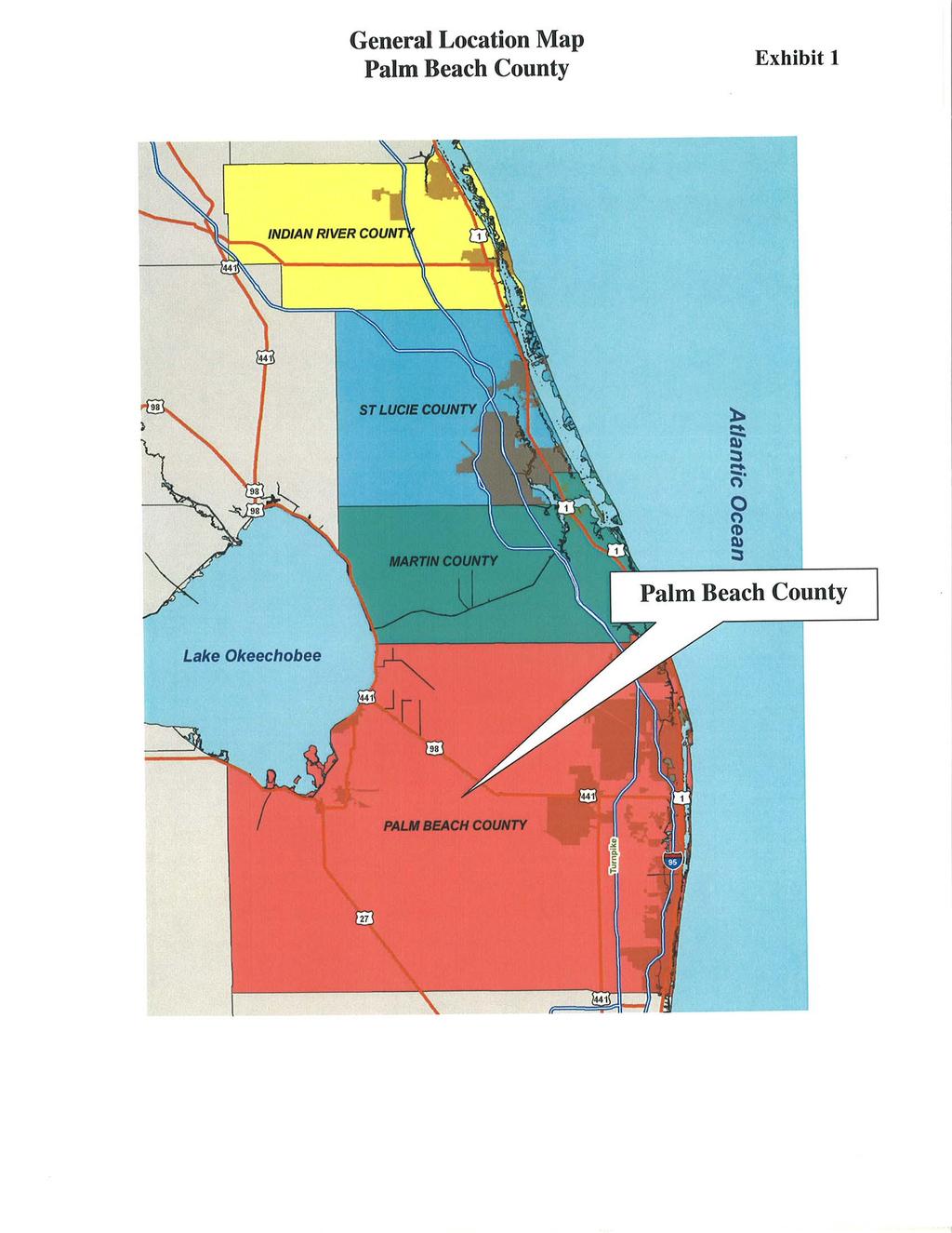
DRAFT Subject to Modifications TREASURE COAST REGIONAL PLANNING COUNCIL
|
|
|
- Hector Daniel
- 5 years ago
- Views:
Transcription
1 DRAFT Subject to Modifications TREASURE COAST REGIONAL PLANNING COUNCIL M E M O R A N D U M To: Council Members AGENDA ITEM 7C From: Date: Subject: Staff June 22, 2007 Council Meeting Local Government Comprehensive Plan Review Draft Amendments to the Palm Beach County Comprehensive Plan DCA Reference No Introduction The Local Government Comprehensive Planning and Land Development Regulation Act, Chapter 163, Florida Statutes, requires that Council review local government comprehensive plan amendments prior to their adoption. Under the provisions of this law, the Department of Community Affairs (DCA) prepares an Objections, Recommendations, and Comments (ORC) Report on a proposed amendment only if requested to do so by the local government, the regional planning council, an affected person, or if an ORC Report is otherwise deemed necessary by the DCA. If the local government requests DCA to prepare an ORC Report, then Council must provide DCA with its findings of consistency or inconsistency with the Strategic Regional Policy Plan (SRPP), and provide any comments and recommendations for modification on the proposed amendments within 30 days of its receipt. Background Palm Beach County has proposed eight amendments to the Future Land Use Map (FLUM) and text amendments to the following elements of the County Comprehensive Plan: Introduction and Administration, Future Land Use, Transportation, Conservation and Capital Improvements. The County has requested a formal review of the amendments by DCA. Evaluation Future Land Use Map (FLUM) The FLUM amendments are summarized in Table 1. The locations of the proposed amendments are shown in Exhibits 2-17.
2 Amendment Number/Name 1. Natural Area Additions (LGA ) 2. Summer Street Property (LGA ) 3. Jog Road Property (LGA ) 4. URA Correctives (LGA ) 5. Lantana Hills Golf Course (LGA ) 6. Glades US Highway 441 Property (LGA ) 7. Orange Avenue Circle Property (LGA ) 8. Military Trail- Sunrise Boulevard Property (LGA ) Total: Table 1 Proposed Amendments to the Future Land Use Map Palm Beach County Comprehensive Plan DCA Reference No Approx. Current FLUM Acreage Designation LR-1 (544 acres) HR-8 (3 acres) RR-10 (139 acres) AP (6 acres) Proposed FLUM Designation CON DRAFT Subject to Modifications Approximate Location Ten parcels, located countywide within six natural areas part of the Paw-paw Preserve, the Lake Okeechobee Trail Head, Cypress Creek, C-18 Triangle, the Pine Glades, and Pond Cypress Natural Areas. 2.6 HR-8 HR miles south of the intersection of 10 th Avenue North and Summer Street in the southeast quadrant of 10 th Avenue North and Congress Avenue. 1.4 MR-5 CH-O/5 West Side of Jog Road, approximately 656 south of Melaleuca Lane LR-2 HR-8 (9.0 acres) HR-12 (8.8 acres) Bounded by the Lake Worth Drainage District L-4 canal on the north, Wallis Road on the south; Haverhill Road on the east; and Holly Drive on the west LR-2 PARK SW Corner of 85 th Avenue South and Woodwind Lane, approximately 500 north of Lantana Road and.5 miles west of the Lantana Road/Lyons Road intersection IND INST East side of US Highway 441, approximately.3 miles south of SR 80 and a mile-and-a-half north of the City of Belle Glade AP INST West of US Highway 441 via Poinciana St reet and Orange Avenue Circle, approx..3 miles south of Hooker Highway and a mile-and-ahalf north of the City of Belle Glade. 0.2 MR-5 CH-O/5 SW corner of Military Trail and Sunrise Boulevard, approx. two miles north of Atlantic Avenue. 2
3 AP CH-O/5 HR-8 HR-12 IND INST LR-1 LR-2 MR-5 PARK RR-10 DRAFT Subject to Modifications Ke y to FLUM Designations Agricultural Production Commercial High Intensity Office (underlying designation of 5 dwelling units per acre) High Residential (maximum of 8 dwelling units per acre) High Residential (maximum of 12 dwelling units per acre) Industrial Institutional and Public Facilities Low Residential (maximum of 1 dwelling unit per acre) Low Residential (maximum of e dwelling units per acre) Medium Residential (maximum of 5 dwelling units per acre) Parks and Recreation Rural Residential (maximum of 1 dwelling unit per 10 acres) 1. Natural Area Additions (LGA ) this amendment would assign a Conservation FLUM designation to six different properties in various locations in the County (see Exhibits 3-8). The properties were acquired as environmentally sensitive lands with funds authorized by the 1999 Conservation Board Referendum. They are part of the Paw Paw Preserve, the Lake Okeechobee Trail Head, Cypress Creek, the C-18 Triangle, the Pine Glades Natural Area and the Pond Cypress Natural Area. 2. Summer Street Property (LGA ) this is a corrective amendment for a property developed with a 32-unit apartment complex. The apartment complex was in existence prior to 1989, but the property was assigned a FLUM designation that is not consistent with the residential density as developed. The amendment will assign the appropriate residential designation. 3. Jog Road Property (LGA ) This is a corrective amendment to assign the appropriate FLUM designation to a small property that was approved for commercial use in The property contains a 6,300 square foot office building. An incorrect FLUM designation was assigned during the preparation of the 1989 comprehensive plan. 4. URA Correctives (LGA ) this amendment is for three separate properties (see Exhibits 11-13) located in close proximity to each other. It is a corrective amendment to better reflect the developed residential density of the properties. The sites were incorrectly assigned a low density residential FLUM designation in The proposed amendment to high density residential designation not only better reflects the actual use, but is consistent with County policy for development/redevelopment in the Urban Redevelopment Area (URA), where the properties are located. 5. Lantana Hills Golf Course (LGA ) this 43 acre property was acquired by the County in It is located contiguous to an old County landfill. The old landfill property (229.2 acres) is being developed as a public golf course. The subject property is 3
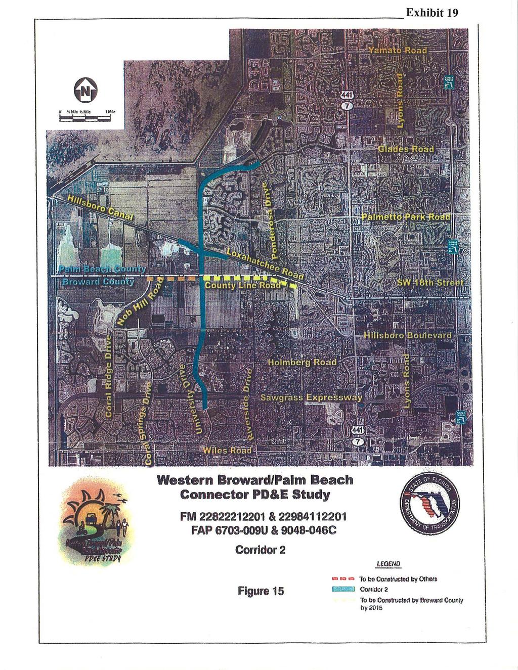
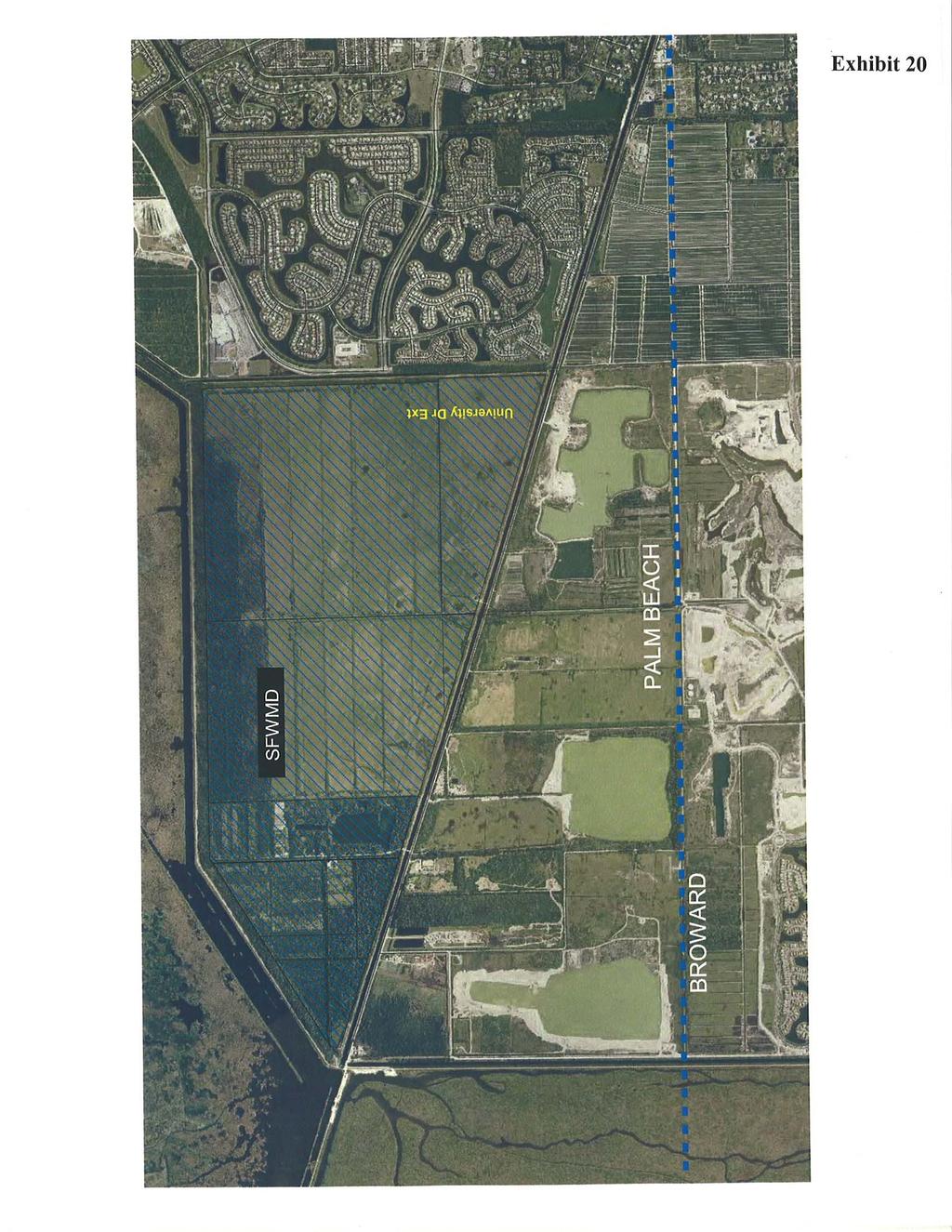
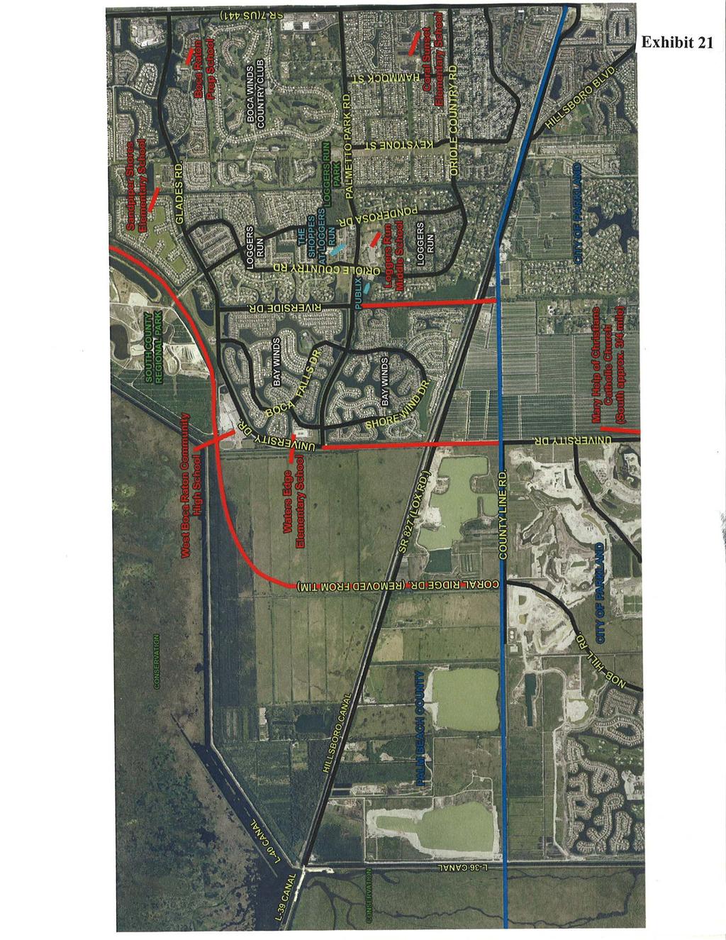
4 DRAFT Subject to Modifications to be assigned a FLUM designation of PARK and is being combined with the landfill property as part of a new golf course. 6. Glades U.S. Highway 441 Property (LGA ) this is a corrective amendment for a property that is part of a Florida Department of Corrections Facility site and has been owned by the State of Florida since An Industrial FLUM designation was incorrectly assigned in It is being assigned an Institutional FLUM designation. 7. Orange Avenue Circle Property (LGA ) this property is also part of a Florida Department of Corrections Facility site and has been owned by the Sate since It was incorrectly assigned a FLUM designation of Agricultural Production in It is also being assigned a FLUM designation of Institutional. 8. Military Trail Sunrise Boulevard Property (LGA ) this property contains an office building and has had commercial zoning since However, it was incorrectly assigned a residential FLUM designation in The amendment would assign a more appropriate Commercial Office designation. Text Amendments 1. University Drive and Riverside Drive TIM and 2020 Map Amendment this amendment would revise the Future 2020 Roadway System by Number of Lanes map (2020 Map) and the Thoroughfare Right-Of-Way Map (TIM) to remove University Drive and Riverside Drive from Lox Road to Palmetto Park Road (see Exhibits 18-21). It would also revise Policy 1.1-n of the Transportation Element to designate adversely impacted roadways that are in need of a corridor master plan. The area west of SR 7 in southern Palm Beach County has been the subject of a number of roadway alignment studies over the past 10 years. At least three roadway connections (University Drive, Riverside Drive, and Coral Ridge Drive) have been anticipated in the area. Coral Ridge Drive, south of Glades Road, was removed from the 2020 Map and the TIM by Palm Beach County in a recent amendment round (#06-1) at the request of the South Florida Water Management District. It would have traversed an area that is to be used as a Comprehensive Everglades Restoration Plan impoundment. The County now proposes to eliminate the potential of both the University Drive and Riverside Drive connections between Palm Beach and Broward counties. The proposed amendments are in conjunction with the anticipated transfer of 1,949 acres of land known as The Wedge Area from Palm Beach to Broward Counties. Legislation to authorize the transfer has been approved by the Florida Legislature and is awaiting the signature of the Governor. Most of the land (1,450 acres) is to be annexed into the City of Parkland, which supports the proposed amendments to the County comprehensive plan. The County indicates that this amendment is necessary due to the desire to prevent increases in vehicular traffic into the West Boca Area. The County proposes no new roadways west of SR 7 to mitigate this action. Previous action by the County has 4
5 DRAFT Subject to Modifications increased the laneage planned for SR 7 from 6 to 8 lanes. Also, Lyons Road, to the east of SR 7 is to be widened from 4 to 6 lanes from Glades Road to Yamato Road. The County also proposes to undertake corridor master plans for failed roadways. These failed roadway segments include SR 7 from Lox Road to Glades Road; Glades Road from SR 7 to Lyons Road; and Lyons Road from the Hillsboro Canal to SW 18 th Street. The County concludes that as a result of these amendments: 1) the LOS on SR 7 gets worse, 2) the LOS on the Florida Turnpike and Sawgrass Expressway get worse; 3) the residents of West Boca and the City of Parkland are supportive; and 4) there may be long-term negative regional impacts on connectivity between the two counties. 2. General CRALLS Text and M ap Amendment this amendment would modify Policy 1.2- f of the Transportation Element (TE) to designate several roadways as Constrained Roadways at Lower Levels of Service (CRALLS) exclusively for development projects with insignificant impacts. Also, Map TE 15.1 is to be revised to incorporate the proposed CRALLS (see Exhibit 22). The Florida Statutes allow an exception to concurrency standards for de minimis impacts. These are impacts that would not affect more than 1% of the maximum volume at the level of service adopted by the local government; and it applies to a roadway link operating at or above 110% of the adopted LOS volume. It cannot be used on a designated hurricane evacuation route. As required, Palm Beach County proposes an annual report of de minimis impacts. The report includes all roadways operating above the 110% service volume. These proposed CRALLS will allow the County to permit additional development without initiating improvements on the subject roadway segments. To achieve the CRALLS designation, the County requires that certain criteria be met and that one or more of a list of mitigation strategies are employed. The causes of constraints on the links being designated at this time vary with each roadway. The facilities are constrained by aesthetics, available right-of-way, or policy considerations. Mitigation measures vary for each roadway. The CRALLS will remain in effect until December 31, 2012; the period for which the analysis of volume was prepared. 3. Okeechobee Boulevard TIM and 2020 Map Amendment this amendment would revise maps TE 1.1 and TE 14.1 to show the expansion of Okeechobee Boulevard from 6 to 8 lanes from SR 7 to La Mancha Avenue Extension. It would also increase the right-of-way from 120 to 200 feet. The expansion of the majority of this segment is already in the 2030 Long-Range Transportation Plan prepared by the Metropolitan Planning Organization (MPO). Okeechobee Boulevard is already over capacity between SR 7 and the Royal Palm Beach High School, which is located just east of La Mancha Avenue on the south side of Okeechobee Boulevard. The County indicates there is an imminent need to expand the capacity of Okeechobee Boulevard to maintain the adopted LOS. Budgeting for the segments to the Royal Palm Beach High School was approved for FY With the addition of the proposed La Mancha /Okeechobee intersection, the widening of Okeechobee Boulevard need not be done beyond the High School. Additional right-ofway is necessary for the widening project. 5
6 DRAFT Subject to Modifications 4. Strategic Intermodal System this amendment adds references to the Strategic Intermodal System (SIS) in three different elements of the County Plan (Introduction and Administration, Future Land Use, and Transportation). The SIS was established by the Florida Legislature and includes appropriate components of the following: 1) the Florida Intrastate Highway System (FIHS); 2) the National Highway System, 3) airport, seaport, and spaceport facilities; 4) rail lines and rail facilities; 5) selected Intermodal facilities; passenger and freight terminals; and appropriate components of the State Highway System, county road system, city street system, inland waterways, and local public transit systems that serve as existing or planned connectors between the components listed in (1)- (4);and 6) existing or planned corridors that serve a statewide or interregional purpose. The County is updating the plan elements to make reference to the SIS where appropriate. 5. State Road 7/Southern Boulevard Intersection CRALLS this amendment would modify policy 1.2-f of the Transportation Element to add a CRALLS designation to the intersection of SR 7 and Southern Boulevard exclusively for a development just south of the Wellington Green Mall. The amendment was initiated at the request of the Village of Wellington. The intersection currently has a temporary CRALLS designation for other projects. The SR 7 Corridor has been a concern for a number of years. A Palms West Corridor Study was completed in 2000, but the study recommendations were not adopted by the affected local governments in the area. In 2005, Palm Beach County committed to work with the local governments on the preparation of a corridor master plan. The corridor study is underway, but not completed. The following series of mitigation measures are to be implemented in conjunction with the CRALLS: 1) The project must prepay Traffic Impact Fees within 6 months of the approval of the Development Order or prior to the issuance of the first building permit, whichever shall occur first. 2) The project shall provide a contribution to help cover some of the funding shortfall for the various transportation related improvements, at a minimum of 1.5 times the applicable impact fee to be used towards off-site roadway improvements. 3) The project shall require an ADA accessible connection to pedestrian parkways that allow direct access to the Mall at Wellington Green and the bus transfer station there. 4) The project shall provide an on-going ride-sharing information service to persons employed by the project. 5) The project shall provide an integrated pedestrian system that connects the buildings to public sidewalks and the enhanced Palm Tran bus stops/shelters. 6) The project shall provide inter-connectivity between complementary neighboring land uses for both vehicular and pedestrian cross-access. 7) The project shall provide a bicycle rack to accommodate commuters using alternative modes of transportation. 8) The project shall provide transit passes to employees using mass transit. 6
7 DRAFT Subject to Modifications County staff recommended denial because they considered the CRALLS premature until the completion and implementation of the corridor study. This is considered important to quantify and mitigate any negative impacts that this and other future development may have along the corridor. 6. De Minimis Policy Update Amendment this amendment revises Transportation Element Policy 1.2-n to be consistent with the Florida Statutes. The Statutes were amended in 2005 to tighten existing restrictions and reporting requirements on de minimis impacts for roadways projected to exceed 110% of the adopted LOS. A de minimis impact is one that would not affect more than 1% of the maximum volume at the adopted LOS of a transportation facility. 7. Urban Development Area - TCEA this amendment would amend the Transportation Element to designate parcels surrounding Military Trail and Congress Avenue within the County Urban Redevelopment Area (URA) as a Transportation Concurrency Exception Area (TCEA). The URA was established through a comprehensive plan amendment in The intent of the URA is to focus on redirecting growth where services and facilities can be provided and to encourage revitalization and redevelopment of the coastal communities. The boundaries of the URA are shown in Exhibit 26. This 25 square mile area has a current population of 76,000. Nine municipalities are within or adjacent to the URA. The goal of the URA is to coordinate and provide redevelopment efforts and infrastructure improvements in the area. The TCEA would allow development and redevelopment in priority areas including the Military Trail and Congress Avenue Corridors. TCEAs allow exceptions to concurrency requirements for transportation facilities in areas specifically designated for urban infill development, redevelopment or downtown revitalization. This TCEA designation is considered consistent with the policies of the County Comprehensive Plan. New Policy 1.2-v designates the area surrounding the Military Trail and Congress Avenue Corridors within the URA as a TCEA. The policy includes several conditions addressing consistency with the master plan for the URA, limits to development, an improved land use mix, transit planning and facilities, neighborhood connectible, etc. A Corridor Master Plan has been prepared for the two corridors to be designated as TCEAs. 8. Hood Road Turnpike Interchange TIM and 2020 Map Amendment this amendment revises Maps TE-1.1 and TE-14.1 to add an interchange at Hood Road and the Florida Turnpike. The amendment is supported by the City of Palm Beach Gardens. The interchange is needed as a reliever for other interchanges due to increasing traffic on the Turnpike. The interchange will be added to the Long Range Transportation Plan by the Palm Beach County MPO. The interchange will improve access to the Scripps Research Institute site. 9. Wildfire Mitigation Text Amendment a new objective and policies are established regarding the prevention of and mitigation of the impacts of wildfires. The new policies are to be added to the Conservation Element. Also, policies in the Fire-Rescue Element are to be revised. The amendments are as a result of the recommendations of the County 7
8 DRAFT Subject to Modifications Local Mitigation Strategy Plan Review Committee. A previous study had identified large areas of the County that are susceptible to wildfires. 10. FLUA Amendment Revisions currently, provisions of the Introduction and Administration Element require that Future Land Use Atlas (FLUA) amendments be based on one or more justification factors. These provisions are to be deleted. Previously, County staff reports placed a large emphasis on a debate with the applicant over justification factors and a demonstration of need. The results were very lengthy, complicated and redundant staff reports. It is anticipated that this change will result in more concise staff reports that focus on the merits of the application. Justification statements and a determination of need will still be required of applicants. However, staff reports are to focus more on consistency with the comprehensive plan, compatibility with the surrounding areas and the implications of the amendment on public facilities. 11. Capital Improvements Element Policy Addition and General Text Revision this element is to be amended to add a new policy regarding proportionate fair share contributions as a revenue source in the Five Year Road Program and Schedule of Capital Improvements. Also, text revisions are to be made to the Capital Improvements, Public School Facilities Utility and Transportation Elements to refer to a 5-Year Capital Improvements schedule. The comprehensive plan previously referenced a six year schedule of improvements. 12. Rural Service Area Policy Corrective Text this amendment deletes Policy 1.4-g from the Capital Improvements Element. It is a corrective amendment for internal consistency in the comprehensive plan. The existing policy is in conflict with the recently revised Service Policy Provisions of the County Plan. 13. Commercial/Industrial Zoning Clarifications the text of the Future Land Use Element (Table ) is to be revised regarding the rezoning of properties zoned commercial prior to This amendment addresses a contradiction in the comprehensive plan. 14. Infill Maximum Density Exception this amendment revises Policy a in the Future Land Use Element regarding infill properties that do not meet the minimum frontage or depth requirements in the County land development regulations. Such properties will now be allowed to develop at the maximum density permitted under their FLUM designation even if the property is not large enough in size to qualify as a Planned Unit Development. 15. Transfer of Development Rights (TDR) Program Revisions this amendment revises Objective 2.6 and several policies in the Future Land Use Element for the purpose of increasing the amount of affordable housing. The County TDR Program dates to 1980; with revisions in 1993 and The purposes of the program were to reduce energy needs, preserve environmentally sensitive lands, protect prime agricultural lands, and provide incentives to lower the unit cost of housing. In 2006, the County adopted amendments requiring a mandatory Workforce Housing Program (WHP) and revising the 8
9 DRAFT Subject to Modifications TDR Program to facilitate the goals and objectives of the WHP. These amendments will allow the TDR Program to support the goals and objectives of the WHP by requiring that 50% of TDR units are for workforce housing and allow WHP TDRs to be used at no cost to the developer. 16. Industrial Future Land Use Revisions this amendment deletes text from the Future Land Use Element regarding auto-related uses within the Industrial FLUM designation. The text previously adopted to address this issue proved to be confusing and is now considered unnecessary. 17. Transit Oriented Development (TOD) Text Amendment this amendment revises Policy 1.2-d of the Transportation Element to allow TODs to be approved when roads and intersections operate at up to 30% above LOS D. It also revises Policy 2.4-d of the Future Land Use Element to further define the elements that qualify a development as Transit-Oriented, including site planning, parking, mix of uses and master planning. The amendments seek to promote integration of the Tri-rail stations with the neighborhoods in which they are located. A mix of commercial, office and residential uses is considered desirable to allow these station locations to become pedestrian-friendly and to integrate rail transit with land uses. A lower LOS will be permitted in TOD areas. It is hoped this will result in jobs, residences and shopping destinations to be located within walking distance of Tri-Rail stations; reducing vehicular trips and increasing ridership of the transit system. Extrajurisdictional Impact The proposed amendments were provided to the Palm Beach County Intergovernmental Plan Amendment Review Committee (IPARC) and were processed on January 26, 2007 and March 16, According to the IPARC Coordinator, no objections have been received. Council received a letter from the City Manager of the City of Coral Springs (attached) expressing opposition to the deletion of University Drive from the County TIM and 2020 map. The City pointed out several reasons why the extension of University Drive is necessary. Due to the potential for extrajurisdictional impacts as a result of the University Drive and Riverside Drive TIM and 2020 Map amendment, Council sent a memorandum dated May 3, 2007 seeking comments on the effects of the proposed amendments to the following: Palm Beach Metropolitan Planning Organization; City of Coral Springs; City of Parkland; South Florida Water Management District; Broward County Planning Services; and Broward County Metropolitan Planning Organization. Council received a response from the City of Parkland dated May 17, The City supports the amendment. Council also received a letter dated May 21, 2007 from the West Boca Community Council in support of the amendment. Council was also copied on a letter dated May 27, 2007 from Palm Beach County Commissioner Burt Aaronson to the FDOT District 4 Secretary. The letter expresses concerns about the effects of cut-through traffic if University Drive is connected to Palmetto Park and Glades Roads. All correspondence received regarding the amendments is included as attachments to this report. 9
10 Effects on Significant Regional Resources or Facilities DRAFT Subject to Modifications Analysis of the proposed amendments indicates that the following proposed amendments would have a negative impact on the regional roadway network: 1. University Drive and Riverside Drive TIM and 2020 Roadway System Map Amendment 2. State Road 7/Southern Boulevard Intersection CRALLS Analysis of Consistency with Strategic Regional Policy Plan FLUM Amendments No comments/recommendations. Text Amendments 1. University Drive and Riverside Drive TIM and 2020 Road System Map Amendment. The Strategic Regional Policy Plan (SRPP) for the Treasure Coast Region indicates that a regional roadway system should be developed that includes predictably spaced and interconnected east-west, north-south streets. Streets should be spaced in order to offer multiple route choices, disperse traffic and discourage local travel on interstates and arterials (Policy ). Council has consistently urged local governments in the Treasure Coast Region to plan for and build an interconnected, integrated network of arterial, collector and local streets, and to do so in such a way that a variety of transportation modes can be utilized. Regarding the roadway network in the subject area, as recently as May 2006, Council encouraged Palm Beach County to consider the acceleration of plans to extend University Drive as a result of the proposed deletion of Coral Ridge Drive from the County TIM and 2020 Roadway System Maps. Rather than accelerating the construction of University Drive, the County now proposes to delete University Drive from the TIM and 2020 Roadway System Maps, effectively eliminating the potential for any roadway connections between Broward and Palm Beach Counties west of SR 7. The analysis of this proposed amendment prepared by the Florida Department of Transportation (FDOT) provides the following points: 1) A clear need has been determined for a Western Broward-Palm Beach Connector in a recent (2005) Project Development and Environmental Study. 2) The FDOT traffic analysis does not agree with the traffic analysis provided by the County in support of this amendment. 3) The University Drive link is critical to regional connectivity. Without it, SR 7 and Lyons Road will become overburdened with congested traffic. 10
11 DRAFT Subject to Modifications 4) Right-of-way for this extension has long been reserved in the Traffic Ways/ Thoroughfare plans for Broward and Palm Beach Counties. Property owners and buyers have been aware of the proposed connection. 5) The expansion of existing roadways as proposed by the County (widening of SR 7 and Lyons Road) cannot be expected to adequately provide for the needs of the region. 6) FDOT, the Palm Beach Metropolitan Planning Organization (MPO) and the Broward MPO have consistently and continuously identified the subject University Drive connection as critical to the regional roadway network. Its removal would negate years of public transportation and policy planning, raise intergovernmental coordination issues, limit regional mobility, and create significant negative impacts to other area roadways. Consistent with the vision of their comprehensive plan, local governments permit the establishment of new neighborhoods and communities. These neighborhoods and communities, according to the SRPP, should contain a balanced, well-planned, compatible mix of land uses appropriately located so that State, local and regional goals are achieved (Policy ). As referenced above, neighborhoods and communities should contain a network of local streets and connections to the regional roadway system (Policy ). Local governments have the responsibility to see that the local street system provides safe and convenient movement for local traffic (pedestrian, bicycle, auto) and that the street system is connected to the regional roadway network at appropriate locations. If these connections are not made, then route choices will be minimal, traffic will not be dispersed and other neighborhoods and communities will be burdened with impacts unnecessarily. There were at least six roadway connections originally proposed between the two counties west of SR 7. For various reasons, four of these connections can no longer be made. Palm Beach County now proposes to remove the last two potential connections. As pointed out in the ORC Report issued by District 4, FDOT (see Attachment F), The proposed amendment seeks reversal of more than twenty years of planning conducted at the local, metropolitan and state levels, along with public involvement and due process, to ensure future regional mobility in western Broward and Palm Beach counties. The perceived benefits of removing the University Drive connection would accrue to a small contingent of local interests at the expense of regional mobility and the larger citizenry. The removal of the University Drive connecting links from the County plan is considered inconsistent with the SRPP. Council recommends that University Drive be maintained on the County TIM and 2020 Roadway System Map and that University Drive be connected with Palmetto Park and Glades Roads as planned. The road should be carefully designed to ensure pedestrian safety, especially in the vicinity of school sites. The roadway should be able to accommodate alternative modes of transportation, including transit, bicycle, and pedestrian traffic. 2. General CRALLS Text and Map Amendment No comments/recommendations. 11
12 3. Okeechobee Boulevard TIM and 2020 Map Amendment DRAFT Subject to Modifications No comments/recommendations. 4. Strategic Intermodal System No comments/recommendations. 5. State Road 7/Southern Boulevard Intersection CRALLS Council has consistently expressed concern about the use/abuse of the CRALLS designation by Palm Beach County. In some situations, there may be important policy reasons or physical corridor constraints that require consideration of a CRALLS or other method to make an exception to an established level of service standard. However, there does not appear to be important policy issues or physical corridor constraints in this case. Furthermore, as Council has indicated previously (e.g. County amendment rounds 02-2, 03-1, 06-1) corridor master plans should be prepared and adopted prior to the designation of any new CRALLS. In this case, a corridor master plan is under preparation, but has not been completed or adopted by the affected local governments. Although a good set of mitigation measures are to be implemented in conjunction with this amendment, the designation of a CRALLS is premature until the completion and adoption of the corridor study. The corridor study may include recommendations for additional mitigation measures. 6. De Minimis Policy Update Amendment No comments/recommendations. 7. Urban Development Area TCEA No comments/recommendations. 8. Hood Road Turnpike Interchange TIM and 2020 Map Amendment No comments/recommendations. 9. Wildfire Prevention Text Amendment The County is commended for proposing policies to address the prevention and mitigation of the impacts of wildfire. However, the policies are limited to those lands governed under County approved management plans. However, there are areas of the County susceptible to wildfires that are not covered by management plans. The County should consider additional policies for these areas that would encourage and provide support for private landowners to take measures to limit the potential damage from wildfires. 12
13 10. FLUA Amendment Revisions DRAFT Subject to Modifications No comments/recommendations. 11. Capital Improvements Element Policy Addition and General Text Revision No comments/recommendations. 12. Rural Service Area Policy Corrective Text No comments/recommendations. 13. Commercial/Industrial Zoning Clarifications No comments/recommendations. 14. Infill Maximum Density Exception No comments/recommendations. 15. Transfer of Development Rights (TDR) Program Revisions No comments/recommendations. 16. Industrial Future Land Use Revisions No comments/recommendations. 17. Transit Oriented Development (TOD) Text Amendment No comments/recommendations. Consistency with Strategic Regional Policy Plan The contract agreement between the DCA and the Treasure Coast Regional Planning Council requires Council to include a determination of consistency with the SRPP as part of the written report to be submitted to the DCA. Council finds the proposed amendments to be CONSISTENT with the SRPP with the exception of the University Drive and Riverside Drive TIM and 2020 Roadway System Map and State Road 7/Southern Boulevard Intersection CRALLS amendments, which are considered to be INCONSISTENT with the SRPP. Recommendation Council should adopt the above comments and approve their transmittal to the Department of Community Affairs. Attachments 13
14
15
16
17
18
19
20
21
22
23
24
25
26
27
28
29
30
31
32
33
34
35
36
37
38
39
40
41
42
43
44
45
46
47
48
49
50
51
52
53
54
55
56
TREASURE COAST REGIONAL PLANNING COUNCIL M E M O R A N D U M. To: Council Members AGENDA ITEM 5H
 TREASURE COAST REGIONAL PLANNING COUNCIL M E M O R A N D U M To: Council Members AGENDA ITEM 5H From: Date: Subject: Staff October 17, 2008 Council Meeting Local Government Comprehensive Plan Review Draft
TREASURE COAST REGIONAL PLANNING COUNCIL M E M O R A N D U M. February 19, 2010 Regional Planning Council Meeting
 TREASURE COAST REGIONAL PLANNING COUNCIL M E M O R A N D U M To: Council Members AGENDA ITEM 5H From: Date: Subject: Staff February 19, 2010 Regional Planning Council Meeting Local Government Comprehensive
TREASURE COAST REGIONAL PLANNING COUNCIL M E M O R A N D U M. To: Council Members AGENDA ITEM 8B5
 TREASURE COAST REGIONAL PLANNING COUNCIL M E M O R A N D U M To: Council Members AGENDA ITEM 8B5 From: Date: Subject: Staff February 17, 2017 Council Meeting Local Government Comprehensive Plan Review
TREASURE COAST REGIONAL PLANNING COUNCIL M E M O R A N D U M. To: Council Members AGENDA ITEM 5I
 TREASURE COAST REGIONAL PLANNING COUNCIL M E M O R A N D U M To: Council Members AGENDA ITEM 5I From: Date: Subject: Staff December 12, 2008 Council Meeting Local Government Comprehensive Plan Review Town
MEMORANDUM AGENDA ITEM #6c
 South Florida Regional Planning Council MEMORANDUM AGENDA ITEM #6c DATE: FEBRUARY 1, 2010 TO: FROM: SUBJECT: COUNCIL MEMBERS STAFF CITY OF PARKLAND PROPOSED COMPREHENSIVE PLAN AMENDMENT (ALTERNATIVE REVIEW)
TRANSPORTATION ELEMENT GOALS, OBJECTIVES, AND POLICIES
 TRANSPORTATION ELEMENT GOALS, OBJECTIVES, AND POLICIES GOAL 2 The City shall provide a safe, convenient, effective, and energy efficient multimodal transportation system which is coordinated with the Future
DRAFT Subject to Modifications
 TREASURE COAST REGIONAL PLANNING COUNCIL M E M O R A N D U M To: Council Members AGENDA ITEM 5P From: Date: Subject: Staff February 20, 2009 Council Meeting Local Government Comprehensive Plan Review Draft
Palm Beach County (University Drive Removal) and Broward County (Transportation Element) Remedial Amendments
 and Broward County (Transportation Element) Remedial Amendments") SR 7/US 441 Transit-Supportive Land Use Planning and Urban Design Assistance (SR 7 Study) Focus TCRPC: Develop detailed analysis of land uses, development regulations, and community visioning all relative
SR 7/US 441 Transit-Supportive Land Use Planning and Urban Design Assistance (SR 7 Study) Focus TCRPC: Develop detailed analysis of land uses, development regulations, and community visioning all relative
TREASURE COAST REGIONAL PLANNING COUNCIL M E M O R A N D U M. To: Council Members AGENDA ITEM 3I
 TREASURE COAST REGIONAL PLANNING COUNCIL M E M O R A N D U M To: Council Members AGENDA ITEM 3I From: Date: Subject: Staff December 8, 2017 Council Meeting Local Government Comprehensive Plan Review Draft
DRAFT Subject to Modifications
 TREASURE COAST REGIONAL PLANNING COUNCIL M E M O R A N D U M DRAFT Subject to Modifications To: Council Members AGENDA ITEM 5F From: Date: Subject: Staff September 17, 2010 Council Meeting Local Government
TREASURE COAST REGIONAL PLANNING COUNCIL M E M O R A N D U M. To: Council Members AGENDA ITEM 4B3
 Revision: 3-15-19 TREASURE COAST REGIONAL PLANNING COUNCIL M E M O R A N D U M To: Council Members AGENDA ITEM 4B3 From: Staff Date: March 8, 2019 Subject: Local Government Comprehensive Plan Review Draft
CHARLES PUTMAN CHARLES PUTMAN AND ASSOCIATES, INC
 MEMORANDUM CHARLES PUTMAN & ASSOCIATES, INC. LAND DEVELOPMENT CONSULTANTS PLANNING ZONING PERMITTING 4722 NW Boca Raton Boulevard, Suite C-106 Boca Raton, Florida 33431 Phone: 561/994-6411 FAX: 561/994-0447
DRAFT Subject to Modifications
 DRAFT Subject to Modifications TREASURE COAST REGIONAL PLANNING COUNCIL M E M O R A N D U M To: Council Members AGENDA ITEM 7C8 From: Date: Subject: Staff January 20, 2017 Council Meeting Local Government
DRAFT Subject to Modifications
 DRAFT Subject to Modifications TREASURE COAST REGIONAL PLANNING COUNCIL M E M O R A N D U M To: Council Members AGENDA ITEM 7C10 From: Date: Subject: Staff January 20, 2017 Council Meeting Local Government
PD&E STUDY SR 9/I-95 FROM SOUTH OF SR 870/COMMERCIAL BOULEVARD TO NORTH OF CYPRESS CREEK ROAD FM # ETDM 14222
 PD&E STUDY SR 870/COMMERCIAL BOULEVARD TO NORTH OF CYPRESS CREEK ROAD FM # 435808-1-22-02 ETDM 14222 WELCOME TO THE KICK-OFF MEETING May 24, 2016 1 1 2 3 4 5 6 PLANNING PROJECT DEVELOPMENT AND ENVIRONMENT
CHAPTER 2 TRANSPORTATION ELEMENT
 SUMMARY CHAPTER 2 TRANSPORTATION ELEMENT A City cannot continue to grow and develop if its citizens cannot reasonably access community facilities and commercial areas. A system of adequate and functional
TREASURE COAST REGIONAL PLANNING COUNCIL M E M O R A N D U M. To: Council Members AGENDA ITEM 4B15
 TREASURE COAST REGIONAL PLANNING COUNCIL M E M O R A N D U M To: Council Members AGENDA ITEM 4B15 From: Date: Subject: Staff May 18, 2018 Council Meeting Local Government Comprehensive Plan Review Draft
SUBJECT: LOCAL GOVERNMENT COMPREHENSIVE PLAN PROPOSED AND ADOPTED AMENDMENT CONSENT AGENDA
 MEMORANDUM AGENDA ITEM #IV.C DATE: APRIL 15, 2019 TO: FROM: COUNCIL MEMBERS STAFF SUBJECT: LOCAL GOVERNMENT COMPREHENSIVE PLAN PROPOSED AND ADOPTED AMENDMENT CONSENT AGENDA Pursuant to the 1974 Interlocal
CHAPTER 7: Transportation, Mobility and Circulation
 AGLE AREA COMMUNITY Plan CHAPTER 7 CHAPTER 7: Transportation, Mobility and Circulation Transportation, Mobility and Circulation The purpose of the Transportation, Mobility and Circulation Chapter is to
VILLAGE OF PALM SPRINGS COMPREHENSIVE PLAN GOALS, OBJECTIVES AND POLICIES
 VILLAGE OF PALM SPRINGS COMPREHENSIVE PLAN GOALS, OBJECTIVES AND POLICIES Adopted November 12, 2009 Amended October 9, 2014 Amended Janury 14, 2016 Amended November 10, 2016 Amended January 11, 2018 (EAR-based)
TRANSPORTATION ELEMENT
 TRANSPORTATION ELEMENT GOAL I: To create and maintain a safe, efficient and aesthetic transportation system that encourages multi-modal transportation and promotes the mobility strategies of the Ocala
DRAFT Subject to Modifications
 DRAFT Subject to Modifications TREASURE COAST REGIONAL PLANNING COUNCIL M E M O R A N D U M To: Council Members AGENDA ITEM 10 From: Date: Subject: Staff February 19, 2016 Council Meeting Local Government
The Need to Develop a Transit Ready Community
 Evaluation & Appraisal Report (EAR) Major Issue # 6 The Need to Develop a Transit Ready Community July 3, 2007 EAR Major Issue # 6 Transit Ready Existing Comp Plan policies apply only to Indiantown Road:
MEMORANDUM AGENDA ITEM #IV.C
 MEMORANDUM AGENDA ITEM #IV.C DATE: NOVEMBER 27, 2017 TO: FROM: COUNCIL MEMBERS STAFF SUBJECT: LOCAL GOVERNMENT COMPREHENSIVE PLAN PROPOSED AND ADOPTED AMENDMENT CONSENT AGENDA Pursuant to Section 163.3184,
INTERGOVERNMENTAL COORDINATION ELEMENT
 Goals, Objectives and Policies COORDINATION ELEMENT GOAL 8.1.: ESTABLISH EFFECTIVE COORDINATION MEASURES AMONG ALL PERTINENT PUBLIC AND QUASI-PUBLIC ENTITIES SO TO BEST MAINTAIN PALM BEACH GARDENS' QUALITY
Eastern Terminus TECHNICAL MEMORANDUM CENTRAL BROWARD EAST-WEST TRANSIT ANALYSIS BROWARD COUNTY, FLORIDA
 Eastern Terminus TECHNICAL MEMORANDUM CENTRAL BROWARD EAST-WEST TRANSIT ANALYSIS BROWARD COUNTY, FLORIDA FINANCIAL PROJECT ID NUMBER 411189-2-22-01 FLORIDA DEPARTMENT OF TRANSPORTATION DISTRICT 4 Prepared
IMPLEMENTATION STRATEGIES. In This Chapter. Goals & Strategies 182 Project List 183 Future Land Use 186 CHAPTER 11 IMPLEMENTATION STRATEGIES
 In This Chapter Goals & Strategies 182 Project List 183 Future Land Use 186 11 IMPLEMENTATION STRATEGIES NORTH AUGUSTA, SC 2017 COMPREHENSIVE PLAN 179 Individual commitment to a group effort that is what
CHAPTER 7: VISION AND ACTION STATEMENTS. Noble 2025 Vision Statement
 CHAPTER 7: VISION AND ACTION STATEMENTS This chapter presents the vision, policy and action statements that transform the comprehensive planning study, an analysis of Noble s past, future trends and community
RECREATION AND OPEN SPACE ELEMENT GOALS, OBJECTIVES, AND POLICIES
 RECREATION AND OPEN SPACE ELEMENT GOALS, OBJECTIVES, AND POLICIES Goal 7 To provide park facilities, recreation programs, and open space resources that are safe, adequate, and accessible to all City residents,
Transit / Housing Oriented Redevelopment
 Broward County Urban Planning and Redevelopment Department Kick-Off Meeting October 24, 2007 Transit / Housing Oriented Redevelopment 1 Future Land Use 2 Broward County Charter Voters approved in 1974.
CITY OF TARPON SPRINGS DCA#11-1AR
 Agenda Item #3.H.2 05/09/11 TAMPA BAY REGIONAL PLANNING COUNCIL LOCAL GOVERNMENT COMPREHENSIVE PLAN ADOPTED AMENDMENT REPORT CITY OF TARPON SPRINGS DCA#11-1AR 1 ADOPTED WITH THE FOLLOWING CHANGES: Ordinance
AWH REPORT OF THE PLANNING AND DEVELOPMENT DEPARTMENT FOR APPLICATION FOR REZONING ORDINANCE TO PLANNED UNIT DEVELOPMENT
 AWH REPORT OF THE PLANNING AND DEVELOPMENT DEPARTMENT FOR APPLICATION FOR REZONING ORDINANCE TO PLANNED UNIT DEVELOPMENT MAY 8, 2014 The Planning and Development Department hereby forwards to the Planning
A. Application Summary
 Item: FUTURE LAND USE ATLAS AMENDMENT STAFF REPORT SMALL SCALE AMENDMENT A. Application Summary I. General BCC ADOPTION PUBLIC HEARING, APRIL 25, 2019 Project Name: ETC Office Warehouse (SCA 2019-002)
9 CITY OF VAUGHAN OFFICIAL PLAN AMENDMENT NO BOCA EAST INVESTMENTS LIMITED
 9 CITY OF VAUGHAN OFFICIAL PLAN AMENDMENT NO. 631 - BOCA EAST INVESTMENTS LIMITED The Planning and Economic Development Committee recommends the adoption of the recommendations contained in the following
Baumgarten MPUD. Exhibit 3 Evaluation Criteria
 Pursuant to LDC subsections 10.02.13 B, 10.02.08 F and Chapter 3 G. of the Administrative Code, staff s analysis and recommendation to the Planning Commission, and the Planning Commission s recommendation
The transportation system in a community is an
 7 TRANSPORTATION The transportation system in a community is an important factor contributing to the quality of life of the residents. Without a sound transportation system to bring both goods and patrons
FUTURE LAND USE ELEMENT
 FUTURE LAND USE ELEMENT GOAL I: To create and sustain a great place to live, play, and prosper Objective 1: The City of Ocala shall incorporate the principles and strategies of the Ocala 2035 Vision into
City of Fort Lauderdale UPTOWN URBAN VILLAGE. Public Workshop December 7, 2016
 Public Workshop December 7, 2016 Workshop Agenda Introductions Project Presentation o o o History Project Scope/Timeline Character of Study Area o o o o Land Use Public Realm/Pedestrian Mobility Multimodal
Mobility Districts and Traffic Studies
 Mobility Districts and Traffic Studies During the last Comprehensive Plan update in 2008, the City of Sarasota identified the need to develop a citywide strategy for enhancing the mobility options of all
Right-of-Way Acquisitions and Relocations Technical Memorandum
 Right-of-Way Acquisitions and Relocations Technical Memorandum Southeast Extension Project Lincoln Station to RidgeGate Parkway Prepared for: Federal Transit Administration Prepared by: Denver Regional
CHAPTER 1. Ms. Guajardo s Class - Central Elementary CH 1 1
 INTRODUCTION CHAPTER 1 Ms. Guajardo s Class - Central Elementary CH 1 1 1.1 SETTING South Centre City is a linear corridor south of Downtown Escondido paralleling Centre City Parkway and South Escondido
open public hearing and allow public comment request to continue LPA public hearing to January 16, 2014 at 10:30 am
 TODAY S AGENDA Work Session LPA Transmittal Public Hearing open public hearing and allow public comment request to continue LPA public hearing to January 16, 2014 at 10:30 am staff will issue a recommendation
RESOLUTION NO. R Refining the route, profile and stations for the Downtown Redmond Link Extension
 RESOLUTION NO. R2018-32 Refining the route, profile and stations for the Downtown Redmond Link Extension MEETING: DATE: TYPE OF ACTION: STAFF CONTACT: Capital Committee Board PROPOSED ACTION 09/13/2018
6. Consistency with Local Plans
 6. Consistency with Local Plans 6.1. Chapter Overview 6.1.1. Introduction This section presents the goals, objectives and policies of municipal, county and state planning entities, as well as known development/redevelopment
AGENDA ITEM 3A Red Hills Coastal Parkway
 March 26, 2007 AGENDA ITEM 3A Red Hills Coastal Parkway REQUESTED BY: CRTPA Members TYPE OF ITEM: Discussion STATEMENT OF ISSUE At the January 22, 2006 Capital Region Transportation Planning Agency (CRTPA)
CITY OF PUYALLUP. Background. Development Services
 CITY OF PUYALLUP Development Services 333 South Meridian Puyallup WA 98371 To: City Council From: Katie Baker, AICP, Planning Division Re: South Hill Neighborhood Plan Adoption Date: (Meeting date: February
4.1.3 LAND USE CATEGORIES
 4.1.3 LAND USE CATEGORIES a. City Center District The City Center District incorporates the existing character and mix of uses in downtown Belmont to encourage redevelopment and new development in keeping
POLICY AMENDMENT AND LAND USE AMENDMENT KILLARNEY/GLENGARRY (WARD 8) NW CORNER OF RICHMOND ROAD AND 33 STREET SW BYLAWS 1P2015 AND 7D2015
 NW CORNER OF RICHMOND ROAD AND 33 STREET SW BYLAWS 1P2015 AND 7D2015") Page 1 of 13 EXECUTIVE SUMMARY This application seeks to redesignate an RC-2 (Residential Contextual One/Two Dwelling) parcel to MC-Gd72 (Multi-Residential Contextual Grade-Oriented) to allow for multi-residential
Page 1 of 13 EXECUTIVE SUMMARY This application seeks to redesignate an RC-2 (Residential Contextual One/Two Dwelling) parcel to MC-Gd72 (Multi-Residential Contextual Grade-Oriented) to allow for multi-residential
Tyvola & Archdale Transit Station Area Plan. June 5, 2008
 Tyvola & Archdale Transit Station Area Plan Second Public Meeting June 5, 2008 Presentation Outline 1. Purpose and Process 2. Station Area Overview 3. Plan Recommendations 4. Comments Received and Proposed
Staff Report and Recommendation
 Community Planning and Development Planning Services 201 W. Colfax Ave., Dept. 205 Denver, CO 80202 p: 720.865.2915 f: 720.865.3052 www.denvergov.org/cpd TO: City Council Neighborhoods and Planning Committee
1.0 Introduction. Purpose and Basis for Updating the TMP. Introduction 1
 1.0 Introduction The Town of Castle Rock is situated between the metropolitan areas of Denver and Colorado Springs, amidst a unique terrain of rolling hills, mesas, ravines, and waterways. Like many Front
Regarding actual construction when development occurs, the following applicable guidelines are provided to address public safety issues:
 MIAMI-DADE COUNTY DEPARTMENT OF PLANNING AND ZONING General Comments 1. COMMENT: A careful review of the application provided shows that there is likely to be an impact on the Miami-Dade Police Department
ROAD CLOSURE AND LAND USE AMENDMENT SILVER SPRINGS (WARD 1) NORTHEAST OF NOSEHILL DRIVE NW AND SILVER SPRINGS ROAD NW BYLAWS 2C2018 AND 29D2018
 NORTHEAST OF NOSEHILL DRIVE NW AND SILVER SPRINGS ROAD NW BYLAWS 2C2018 AND 29D2018") Page 1 of 19 EXECUTIVE SUMMARY This application proposes redesignating two parcels in the community of Silver Springs from Special Purpose Future Urban Development (S-FUD) District and undesignated road
Page 1 of 19 EXECUTIVE SUMMARY This application proposes redesignating two parcels in the community of Silver Springs from Special Purpose Future Urban Development (S-FUD) District and undesignated road
Northwest Rail Corridor and US 36 BRT Development Oriented Transit Analysis 4.4 STATION AREA FINDINGS
 4.4 STATION AREA FINDINGS Each station is different, and each one requires a separate set of recommendations based on the vision for the site. This section outlines an initial TOD strategy and recommendations
City Of Sparks Planning Commission Item
 Page 1 of 12 City Of Sparks Planning Commission Item Meeting Date: May17, 2012 Subject: PCN12009, Public Hearing, Consideration and possible action on a Master Plan Amendment and Rezoning request to change
Intergovermental Coordination
 Intergovermental Coordination CITY OF WINTER PARK CHAPTER 8: INTERGOVERNMENTAL COORDINATION ELEMENT INTERGOVERNMENTAL COORDINATION ELEMENT GOAL 8-1: PROVIDE FOR IMPROVED INTERGOVERNMENTAL COORDINATION
Locate higher density development along transit corridors and near
 Vision Statement: Provide progressive direction for the City s multi-modal transportation system in a way that sustains the City s natural, aesthetic, historic, cultural, social and economic resources.
Boca Raton II Tri-Rail Station PD&E Study and 30% Documents Public Kick-Off Meeting. August 29, 2017 Spanish River Library
 Boca Raton II Tri-Rail Station PD&E Study and 30% Documents Public Kick-Off Meeting August 29, 2017 Spanish River Library Introductions 2 Partner Stakeholder Agencies FDOT District Four Palm Beach Metropolitan
Planning & Zoning Commission Staff Report
 Planning & Zoning Commission Staff Report Meeting Date: May 26, 2015 Drafted by: Katherine Harrison-Rogers CASE # Z2886 PROJECT NAME: APPLICANT/ REPRESENTATIVE: Shawna Runyan PROPERTY OWNER: 1840 (previously
The West Vaughan Employment Area Secondary Plan Policies
 Part 2: The West Vaughan Employment Area Secondary Plan Policies 2.1 General Policies It is the policy of Council: 2.1.1. That the West Vaughan Employment Area (the WVEA), identified on Schedule 1, will
BROOKHILL NEIGHBORHOOD MODEL ZONING MAP AMENDMENT PREFACE TO APPLICATION
 BROOKHILL NEIGHBORHOOD MODEL ZONING MAP AMENDMENT PREFACE TO APPLICATION June 15, 2015 Revised: August 1, 2016 I. VISION Brookhill is a proposed community based upon the principles of Albemarle County
TENNESSEE STATE ROUTE 109 CORRIDOR MANAGEMENT AGREEMENT MEMORANDUM OF UNDERSTANDING CORRIDOR MANAGEMENT ALONG STATE ROUTE 109
 TENNESSEE STATE ROUTE 109 CORRIDOR MANAGEMENT AGREEMENT MEMORANDUM OF UNDERSTANDING CORRIDOR MANAGEMENT ALONG STATE ROUTE 109 I. Purpose The purpose of this Agreement is to provide a framework for the
PLANNING COMMISSION. Agenda Item # 3.
 PLANNING COMMISSION Agenda Item # 3. CASE SUMMARY Conditional District Rezoning Planning Commission February 4, 2015 CD-9-215 Jeff Walton, 341-3260, jeff.walton@wilmingtonnc.gov Staff recommendation CONDITIONAL
Figure 5. Previously Identified Viable Corridors
 OVERVIEW The Central Florida Expressway Authority (CFX) is evaluating the potential to expand SR 408 from its current eastern terminus along SR 50 to SR 520 in northeastern Orange County, Fl. This new
A. WHAT IS A GENERAL PLAN?
 I. Introduction A. WHAT IS A GENERAL PLAN? A general plan is the planning guideline for the future of a city. It contains goals and policies which regulate urban development, the protection of the natural
4. ENVIRONMENTAL IMPACT ANALYSIS 7. LAND USE AND PLANNING
 4. ENVIRONMENTAL IMPACT ANALYSIS 7. LAND USE AND PLANNING 4.7.1 INTRODUCTION The following analysis discusses the consistency of the Proposed Project with the corresponding land use and zoning designations
COLVER ROAD INDUSTRIAL CONCEPT PLAN
 COLVER ROAD INDUSTRIAL CONCEPT PLAN A CONCEPTUAL LAND USE AND TRANSPORTATION PLAN FOR TA-4 AN URBAN RESERVE AREA OF THE CITY TALENT City of Talent Adopted by City Council Resolution No., June, 2015 PART
1.0 Circulation Element
 5/9/18 1.0 Circulation Element 1.1 Introduction As growth and development occur in Apache County, enhancements to its circulation system will be necessary. With time, more roads will be paved and air and
Land Use Amendment in Southwood (Ward 11) at and Elbow Drive SW, LOC
 at and Elbow Drive SW, LOC") 2018 November 15 Page 1 of 10 EXECUTIVE SUMMARY This land use amendment application was submitted by Rick Balbi Architect on 2017 August 31 on behalf of Sable Developments Ltd, and with authorization from
2018 November 15 Page 1 of 10 EXECUTIVE SUMMARY This land use amendment application was submitted by Rick Balbi Architect on 2017 August 31 on behalf of Sable Developments Ltd, and with authorization from
Woodburn Comprehensive Plan Growth Management Goals and Policies
 Goal Woodburn Comprehensive Plan Growth Management Goals and Policies G-1. The City's goal is to manage growth in a balanced, orderly and efficient manner, consistent with the City s coordinated population
Warren County/Bowling Green Focus 2030 Comprehensive Plan VOLUME 1 INDEX
 Appendix 5: Index VOLUME 1 INDEX A Aesthetics ES-6, FLU-15, FLU-17, FLU-24, NCR-7 Agricultural Base FLU-18, FLU-20 Agricultural Centers, Rural FLU-11 Agricultural District NCR-17-NCR-18 Agricultural Economy
Transportation. Strategies for Action
 Transportation A major priority for the Overlake Neighborhood is to develop a multimodal transportation system. To achieve this system, a balance has to be found among travel, circulation and access needs;
Cobb County Design Guidelines Mableton Parkway & Veterans Memorial Highway Community Design Workshop January 12, 2017
 Community Design Workshop January 12, 2017 Agenda Opening Remarks / Introductions Scope of Work Existing Conditions Key Issues / Opportunities VPS Summary Draft Vision & Goal Statement Implementation Concepts
Dwelling Units Max 12 dwelling units per acre/min 8 dwelling units per acre. Development Mix 80% non residential/20% residential
 13. OSTEEN LOCAL PLAN Background: The Osteen Local Plan area is located in southwest Volusia County along the SR 415 corridor between Lemon Bluff Road and Acorn Lake Road and includes 3,990 acres. The
2. MULTI-MODAL TRANSPORTATION ELEMENT Goals, Objectives, and Policies
 2. Goals, Objectives, and Policies GOAL 2-1: TO INTEGRATE THE MULTI-MODALTRANSPORTATION SYSTEM WITH THE FUTURE LAND USE ELEMENT, THE FUTURE LAND USE MAP, ANDTHE LAND DEVELOPMENT CODE TO GUIDE DEVELOPMENT
Subject: Hendry County Evaluation and Appraisal Report Letter of Understanding - Identification of Major Issues
 HENDRY COUNTY PLANNING & ZONING DEPARTMENT POST OFFICE BOX 2340 165 S. LEE STREET LABELLE, FLORIDA 33975 (863) 675-5240 FAX: (863) 675-5317 SUNCOM 744-4750 November 16, 2007 Mr. Mike McDaniel, Chief Office
DRAFT Subject to modifications
 TREASURE COAST REGIONAL PLANNING COUNCIL DRAFT M E M O R A N D U M To: Council Members AGENDA ITEM 7C From: Date: Subject: Staff September 17, 2010 Council Meeting Commuter Rail Update Resolution of Support
1.0 INTRODUCTION 1.1 TH 14 WEST STUDY AREA Project Description Functional Classification Purpose of the Project
 1.0 INTRODUCTION 1.1 TH 14 WEST STUDY AREA 1.1.1 Project Description The Trunk Highway (TH) 14 West Corridor is a two-lane roadway approximately 22 miles in length. Located in Nicollet County, the corridor
Implementation Guide Comprehensive Plan City of Allen
 Implementation Guide 2030 Comprehensive Plan City of Allen DRAFT 2015 Implementation Guide Allen 2030 Comprehensive Plan INTRODUCTION The Comprehensive Plan serves as a guide for the growth and development
EAR WORKSHOP FOR PALM BEACH COUNTY LOCAL GOVERNMENTS APRIL 2010 TREASURE COAST REGIONAL PLANNING COUNCIL
 EAR WORKSHOP FOR PALM BEACH COUNTY LOCAL GOVERNMENTS APRIL 2010 TREASURE COAST REGIONAL PLANNING COUNCIL Why Should I Care about Transportation & Land Use? Congestion or Mobility Pick One!! Congestion
Access Management: An Overview
 Figures 1-5 Below Evolution of development along a highway. In the early stages, land along the road is used for farming with little traffic generated. As time passes, the highway corridor becomes a de
Issues Requiring Future Study
 Issues Requiring Future Study Transportation planning is an ongoing process that tends to identify new issues as it finds solutions for others. Some issues are so complex that a solution to one problem
Tyvola & Archdale Transit Station Area Plan. May 15, 2008
 Tyvola & Archdale Transit Station Area Plan First Public Meeting May 15, 2008 Presentation Outline 1. Purpose and Process 2. Station Area Overview 3. Plan Recommendations Vision Land Use Transportation
Executive Summary. The goals of the Plan are to:
 Executive Summary The Wiscasset Bath Road Master Plan (Plan) seeks to maximize development opportunities along Bath Road through the strategic coordination of traffic infrastructure improvements, land
South Davis County COMMUNITY SPOTLIGHT
 South Davis County COMMUNITY SPOTLIGHT Davis/SLC Community Connector Bus Rapid Transit line connecting SLC & Davis County RTP Phase 1 Project Generate 3,100 average weekday riders Relieve congestion on
INTERGOVERNMENTAL COORDINATION ELEMENT Inventory Analysis
 INTERGOVERNMENTAL COORDINATION ELEMENT Inventory Analysis 2.176 INTRODUCTION This Element outlines and analyzes those issues that require intergovernmental cooperation to achieve plan implementation. The
CHAPTER 12 IMPLEMENTATION
 CHAPTER 12 IMPLEMENTATION The 2010 Town of Denton Comprehensive Plan is intended to capture a vision of the future of Denton. As such, it provides a basis for a wide variety of public and private actions
CITY COUNCIL AGENDA REPORT
 CITY COUNCIL AGENDA REPORT Subject: COUNCIL MOTION LRT ALIGNMENT REMOVAL FROM THE TRANSPORTATION MASTER PLAN On February 10, 2016 Councillor Hughes provided notice in accordance with Section 23 of Procedure
CITY PLANNING COMMISSION AGENDA. ITEM NO(s): C.1 C.3 STAFF: STEVE TUCK
: C.1 C.3 STAFF: STEVE TUCK") Page 34 CITY PLANNING COMMISSION AGENDA ITEM NO(s): C.1 C.3 STAFF: STEVE TUCK FILE NOS: CPC ZC 12-00035 QUASI-JUDICIAL CPC NV 12-00036 QUASI-JUDICIAL AR DP 12-00039 QUASI-JUDICIAL PROJECT: APPLICANT: OWNER:
Page 34 CITY PLANNING COMMISSION AGENDA ITEM NO(s): C.1 C.3 STAFF: STEVE TUCK FILE NOS: CPC ZC 12-00035 QUASI-JUDICIAL CPC NV 12-00036 QUASI-JUDICIAL AR DP 12-00039 QUASI-JUDICIAL PROJECT: APPLICANT: OWNER:
Osceola County Board of County Commissioners 1 Courthouse Square, Suite 1100 Kissimmee, FL
 1/10/11 Item Number DRI08-0006 Osceola County Board of County Commissioners 1 Courthouse Square, Suite 1100 Kissimmee, FL 34741 407-742-0200 Applicant & Owner Center Lake Properties, LLLP and Formally
Goals, Objectives and Policies
 Goals, Objectives and Policies GOAL ONE: THE PATTERN OF LAND USE IN PINELLAS COUNTY SHALL PROVIDE A VARIETY OF URBAN ENVIRONMENTS TO MEET THE NEEDS OF A DIVERSE POPULATION AND THE LOCAL ECONOMY, CONSERVE
12 Intergovernmental Coordination
 Intergovernmental Coordination Supporting Data The purpose of the Intergovernmental Coordination Element is to identify and resolve incompatible goals, objectives, policies and development proposed in
Proposed Comprehensive Plan Strategies DRAFT for discussion June 28, 2017
 Proposed Comprehensive Plan Strategies DRAFT for discussion June 28, 2017 Land Use Rural Areas Refine the Farm and Forest area (FF) Update FF boundaries to account for existing lots less than five acres
Gratigny Parkway East Extension Project Development & Environment (PD&E) Study
 Study") Gratigny Parkway East Extension Project Development & Environment (PD&E) Study Session 4: Presentation of Charrette Results December 8, 2010 MDX Work Program #: 92407 ETDM#: 11500 Project Location & Description
Gratigny Parkway East Extension Project Development & Environment (PD&E) Study Session 4: Presentation of Charrette Results December 8, 2010 MDX Work Program #: 92407 ETDM#: 11500 Project Location & Description
Citizen Comment Staff Response Staff Recommended Revision Planning Committee
 Citizen Comment Staff Response Staff Recommended Revision Planning Committee Area No. 1: Owner desires retail land uses. Area No. 1a: Owner of two small parcels adjacent to Area No. 1 desires retail land
Date: April 10, 2017 City Council Work Session April 24, 2017: Status Report on the Comprehensive Plan Update and Transportation Master Plan
 AGENDA REPORT To: From: By: Honorable Mayor and City Council Members Warren Hutmacher, City Manager Sharon Ebert, Director Community Development Date: April 10, 2017 Agenda: City Council Work Session April
PROJECT STATEMENT LOCATION/DESIGN PUBLIC HEARING. 19 th AVENUE NORTH EXTENSION PROJECT FROM SPRINGDALE DRIVE TO NORTH 2 ND STREET/U.S.
 PROJECT STATEMENT LOCATION/DESIGN PUBLIC HEARING 19 th AVENUE NORTH EXTENSION PROJECT FROM SPRINGDALE DRIVE TO NORTH 2 ND STREET/U.S. 67 HEARING LOCATION: ERICKSEN COMMUNITY CENTER 1401 11 TH AVENUE NORTH
G. RECREATION AND OPEN SPACE ELEMENT. The following summarizes the Recreation and Open Space Element:
 G. RECREATION AND OPEN SPACE ELEMENT The purpose of the Element is to provide the framework and direction for a comprehensive system of public and private sites for recreation, including, but not limited
TRANSIT ORIENTED DEVELOPMENT PINELLAS COUNTY MPO LIVABLE COMMUNITIES INITIATIVE PINELLAS COUNTY COMPREHENSIVE PLAN AMENDMENTS
 PINELLAS COUNTY MPO LIVABLE COMMUNITIES INITIATIVE MODEL LAND DEVELOPMENT CODE TRANSIT ORIENTED DEVELOPMENT PINELLAS COUNTY COMPREHENSIVE PLAN AMENDMENTS MPO Livable Communities Initiative Goal: Improve
FIRE AND RESCUE. Intent
 FIRE AND RESCUE Intent The Fire and Rescue Plan is designed to maintain Prince William County as a safe community, reducing loss of life, injury, and property from fire and/or accident. The mission of