UNIVERSITY TOWN NEIGHBOURHOODS 5.2 ECO-CORRIDOR MELBOURNE CAMPUS MASTER PLAN 2014
|
|
|
- Anne Underwood
- 5 years ago
- Views:
Transcription
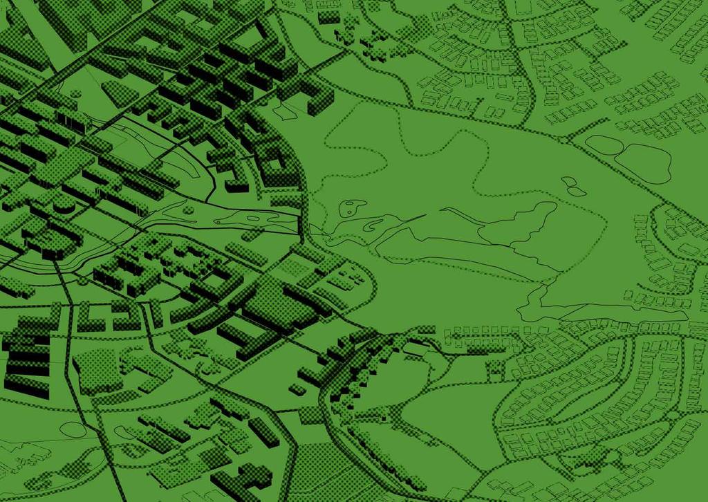
1 5.2 ECO-CORRIDOR 37

2 ECO-CORRIDOR EXISTING CONDITIONS & VISION NEIGHBOURHOOD VISION Investment in the Eco-corridor Neighbourhood will signify the University s commitment to supporting local ecology and flora and fauna diversity. The main components of the Eco-corridor are the Wildlife Sanctuary, the Central Moat and the area south of Kingsbury Drive. Each component will be treated uniquely, building upon the existing character and strengths of the area. A network of shared paths will be developed throughout the Eco-corridor, providing much needed connections between Darebin Creek and the neighbourhoods north of the Wildlife Sanctuary. KEY ATTRIBUTES & SUPPORTIVE ELEMENTS Green space accounts for over 30% of the campus. The open space facilitates sport, recreation and important local ecologies. High Ecological Value of the Moat system. Supports regional biodiversity and ecology networks. Plays a key role in both local and regional stormwater treatment. BARRIERS TO CHANGE Old and tired materials and finishes within existing outdoor courtyards require upgrading. The Moat is disconnected from the Core Campus, visually and physically. It currently acts as an open stormwater drain for the whole campus. The facilities within the Wildlife Sanctuary are tired, and in need of upgrading to facilitate effective teaching and research. The Wildlife Sanctuary is isolated from Core Campus activities and surrounding neighbourhoods by major road networks and visually intrusive fencing. Service roads and access paths will be required across the University Town. This access network will need to be carefully managed to ensure it does not dominate the landscape m


3 LANDSCAPE CONTEXT The Eco-corridor traverses the length of the campus, linking Darebin Creek with ecological and biodiversity assets to the north. The water system that runs through the Eco-corridor is currently not well maintained. Weeds have infested the corridor, and the buildings and open spaces turn their back on the water system. The Moat acts as an open stormwater drain for the campus and upstream development. The Moat currently contains significant exotic tree species, such as Willows. LANDSCAPE VISION THE WILDLIFE SANCTUARY An outdoor living laboratory for education and research will be created, providing a platform for the pursuit of the University s Research Focus Areas and accommodating archaeology, botany and zoology courses and research activities. The Wildlife Sanctuary will primarily be a place of research and learning. The facilities will be upgraded to provide quality alternative research laboratories and classrooms, so students can spend more time in the field. Providing access boardwalks and observation platforms will help facilitate learning, while also protecting the existing vegetation. The Sanctuary is open to the public, and has the opportunity to host community planting days, provide limited indigenous plant sales and retail, enabling local involvement and investment. There will be excellent signage and wayfinding throughout the Sanctuary, providing knowledge and information to all visitors about the range of flora and fauna within the ecosystem. A consolidation of service roads and storage areas (and their repositioning to more discrete locations) and enhanced fencing treatments will make the Sanctuary an attractive destination. Providing quality amenities for local visitors, and upgrading the nursery entry experience would make this a desirable outing for the community and school groups. THE MOAT The Moat system and environs will become a public destination within the campus the Central Parkland. The Moat will have activated edge walks, and will facilitate shared bicycle use. Bridges will connect the Core Campus and the colleges at regular intervals, celebrating moments of art and sculptural form. The Moat will be an activity spine, linking active and passive recreation areas with hospitality, events, learning areas, and research, employment, retail health, cultural and sporting hubs. Memorable attributes of the existing network will be complemented with new uses. Back of house areas and service road prioritisation will be discouraged. There will be event lawns, public lighting, curated artwork and place interpretation. Primarily, the Moat will be a place of engagement with water and environment. It will have both formal interactions with the water s edge, and areas where the riparian water corridor is rehabilitated. The Moat presents significant opportunities for habitat, ecology, water quality, learning and landscape experience. The Moat will engage students, staff and the community in the ecological water story of the campus. It will be used to improve the water quality of the stormwater received into the system, and provide a learning/observation function that complements the University s RFA ambitions. UNIVERSITY TOWN NEIGHBOURHOODS ECO-CORRIDOR m Urban courtyards and pathways Passive recreation areas Creek revegetation planting Water bodies Existing built form Proposed built form SOUTH OF KINGSBURY DRIVE The vision for the area south of Kingsbury Drive is to provide an endemic revegetated and rehabilitated riparian and woodland ecosystem that completes the linkage between the Moat system and Darebin Creek. Importantly, the area will be set aside for offset planting to facilitate development in other areas of the campus and will be a repository for the enhancement of the University s stormwater harvesting, treatment and reuse. Existing paths shall be consolidated and upgraded to control movement and provide quality connections between the Darebin Creek Trail and the campus, improving the amenity of the area. 39

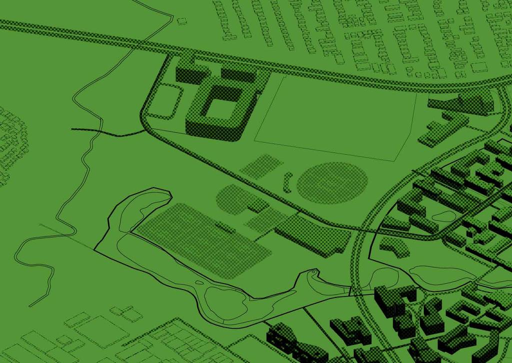
4 NEIGHBOURHOOD LANDSCAPE PLAN WILDLIFE SANCTUARY Upgrade the learning facilities to create opportunities for alternative research laboratories and classrooms within this unique environment. Provide access boardwalks and observation platforms to facilitate learning, while also protecting the existing vegetation. Consolidate surface materials and visually reduce the impact of service roads, storage areas and fences to improve the visual appeal of the Wildlife Sanctuary. Provide quality amenities for visitors and a nursery entry experience to make this an attractive outing for families and school groups. KEY INITIATIVES Rejuvenate the Wildlife Sanctuary. Upgrade the presence of the Sanctuary within the community, by making the entry more prominent. This will include street signage within surrounding suburbs for access locations, as well as compliant access from car parks and streets Provide a new access points into the Sanctuary from the campus. Facilitate a shared path connection from Darebin Creek, via the Core Campus, and north to the Wildlife Sanctuary. Upgrade learning and research facilities, providing alternative classroom environments for students and staff. Provide access boardwalks and observation platforms that help to facilitate learning, while also protecting the existing vegetation. Consolidate surface materials and visually reduce the impact of service roads, storage areas and fences. Fencing chosen will be sympathetic to its surroundings. Provide quality signage and interpretive 5 information so that the site is easily accessible for both students and the local community. Create a safe haven for fauna within the Sanctuary. Fauna will be protected and able to be observed and bred depending on research programmes. Raise the informal embankments within the Wildlife Sanctuary to assist with flood mitigation downstream through the Moat system. Protect the very high significance remnant River 6 Red Gum native vegetation standing within the north-east of the Wildlife Sanctuary and significant individual River Red Gums across the reserve. Integrate Plains Grassy Wetland vegetation community within the riparian areas surrounding the wetlands within the Wildlife Sanctuary. Enhance the ecological corridor linkage 7 between Gresswell Grange and Darebin Creek through active management of the Plains Grassy Woodland vegetation within the Wildlife Sanctuary management. There are opportunities to enhance ecological value through the implementation of floating macrophyte islands and vegetated swales to improve water quality and manage surface water flow within and downstream of the Wildlife Sanctuary. Support research in the areas of revegetation and stream ecology through the installation of macrophyte islands within the Wildlife Sanctuary. There is an opportunity to support the introduction of listed fauna, including fish species, into the Wildlife Sanctuary subject to the installation of appropriate fencing and addressing of overland flow issues m Urban courtyards and pathways Passive recreation areas Creek revegetation planting Water bodies 2 Existing built form 3 Proposed built form 7 6


5 3 4 5 UNIVERSITY TOWN NEIGHBOURHOODS Indicative section location Boardwalk and pedestrian path Existing wetlands Revegetate EVC 25 Plains Grassy Wetland Existing wetlands 4

6 NEIGHBOURHOOD LANDSCAPE PLAN THE MOAT Enhance the Moat edge conditions by providing well defined shared pathways for pedestrian and bicycle access on both sides of the waterway. Create meaningful engagement with water. In areas of the Core Campus, provide an urban interface that allows students and staff to interact with this asset. Provide high quality bridge connections across the Moat for pedestrians and cyclists. Revegetate the Moat embankments to stabilise the edges and provide high quality habitat, enhancing the amenity and ecological value of the waterway. KEY INITIATIVES Develop the Moat as the Central Parkland - the main activity spine that connects the University Town. This should include shared access paths, cafes, kiosks and interaction with water. Provide stronger connections across the water to encourage movement from the Core Campus to the Colleges and beyond to the R&D Park. Develop the Core Campus interface to relate to 2 the Moat in a civic manner, providing hard edges that encourage students and activities to occur along the water edge. Provide new developments that spill out into the parkland as outdoor seating or dining, ensuring that building facades are activated and engaging. 3 Develop primary circulation for cyclists and 3 pedestrians close to the Moat corridor, providing direct connection through the campus from Darebin Creek to northern neighbourhoods. Provide a secondary circulation path along the Moat for strolling. Revegetate parts of the Moat network to improve water quality and biodiversity outcomes m Urban courtyards and pathways Passive recreation areas Creek revegetation planting Water bodies Existing built form Proposed built form


7 2 UNIVERSITY TOWN NEIGHBOURHOODS Indicative section location The La Trobe Tan Menzies College Cafe/dining Simpson Place Shared pedestrian and cycle area Engagement with water zone 5 5m minimum Timber decking edge to water The Moat Revegetate EVC 68 Creek Grassy Woodland. This area can include minimal impact walking tracks. Revegetation zone 8 5m minimum Repurposed Moat Drive pedestrian and cycle path 43

8 ECO-CORRIDOR NEIGHBOURHOOD VISUALISATION THE MOAT Indicative section location The La Trobe Tan Core Campus Shared pedestrian and cycle path The Moat Revegetate EVC 68 Creek Grassy Woodland The Moat Revegetate EVC 68 Creek Grassy Woodland Menzies College 44 Repurposed Moat Drive pedestrian and cycle path

9 UNION BUILDING MOAT INTERFACE Indicative section location UNIVERSITY TOWN NEIGHBOURHOODS ECO-CORRIDOR Shared pedestrian and cycle path The Moat The La Trobe Tan Revegetation zone 8 5m minimum Revegetate EVC 66 Creek Grassy Woodland. This area can include minimal impact walking tracks. Campus Parkland Repurposed Moat Drive pedestrian and cycle path Union Building 45

10 NEIGHBOURHOOD LANDSCAPE PLAN ECO-CORRIDOR SOUTH OF KINGSBURY DRIVE Connect the Darebin Creek Trail to the University Town by enhancing the current pedestrian and cycle path. Return the area to its endemic ecological character through plantings of Plains Grassy Woodland, Creek Grassy Woodland and Stream Bank Shrubland. Through the planting of hubs of threatened flora species, establish biohubs to support dispersal and regenerate tracts of habitat and creating the opportunity for species to re-disperse and establish healthy/self-sustaining populations. Enhance the quality of Darebin Creek by actively managing access and discouraging development and activities that may cause unacceptable levels of air, noise, soil and water pollution. Provide opportunities for research stations and outdoor classrooms within this unique environment. Work with external stakeholders with an interest in the health of Darebin Creek to realise its management objectives through an integrated sub-catchment approach to improving the flow and quality of water entering the watercourse. KEY INITIATIVES Connect the Darebin Creek Trail to the campus and provide bicycle and pedestrian links to the suburbs north and south. Improve water quality and manage surface water flow to Darebin Creek through riparian vegetation plantings along the Creek and constructed wetlands and by active management of weeds, litter control and pest species. Protect ecologically important old River Red Gums, endangered flora species and create habitat for endangered fauna species within the Offset Area. Enhance the ecological value of the area through the implementation of floating macrophyte islands and vegetated swales to improve water quality and manage surface water flow within the constructed wetlands m Urban courtyards and pathways Passive recreation areas Creek revegetation planting Water bodies Existing built form Proposed built form


11 2 UNIVERSITY TOWN NEIGHBOURHOODS ECO-CORRIDOR Indicative section location Darebin Creek Trail Darebin Creek Revegetate EVC 25 Plains Grassy Wetland The La Trobe Tan (Stage 2) 47
12 48
UNIVERSITY TOWN NEIGHBOURHOODS 5.5 HOUSING MELBOURNE CAMPUS MASTER PLAN 2014
 5.5 169 EXISTING CONDITIONS & VISION NEIGHBOURHOOD VISION The provision of on-campus housing into the future will continue to be an important element of the La Trobe University experience. A long-term
7. Biodiversity & Conservation Areas
 7. & Conservation Areas 7.1. Objectives The objectives of biodiversity and conservation areas are founded on the need to recognise the importance of biodiversity and acknowledge the need to protect, restore
10.0 Open Space and Public Realm
 10.0 Open Space and Public Realm 10.0 Open Space and Public Realm The Public Open Space System is comprised of: outdoor spaces available for public use that are either publicly owned (e.g., parks and
GREENBANK DEVELOPMENT MASTERPLAN
 DEVELOPMENT MASTERPLAN POTENTIAL TRAIN STATION COMMUNITY CENTRE Greenbank will be a connected masterplanned community providing easy access to local and surrounding amenity. Affordable quality homes, green
STRATEGIES INTRODUCTION
 4.0 STRATEGIES INTRODUCTION MASTER PLAN STRATEGIES MASTER PLAN THEMES The Master Plan Strategies section establishes campus-wide themes and strategies that underpin the Melbourne Campus Vision for the
Wetland Design Manual. A1: Vision, core outcomes and aspirational outcomes
 Wetland Design Manual A1: Vision, core outcomes and aspirational outcomes Table of contents Introduction 5 Vision 6 Core outcomes 7 Effective pollutant removal and flow management... 7 Community safety...
ACKNOWLEDGEMENTS PROJECT TEAM
 ACKNOWLEDGEMENTS La Trobe University proudly acknowledges the Dja Dja Wurrung people, the traditional custodians of the land upon which the Bendigo Flora Hill campus is located. We recognise that Indigenous
elbridge Core Strategy
 C elbridge Core Strategy Celbridge is designated as a Moderate Growth Town in the RPGs. The County Development Plan reinforces this designation in its settlement strategy. Moderate Growth Towns within
MCCOYS CREEK RESTORATION 30% DESIGN
 MCCOYS CREEK RESTORATION 30% DESIGN THE MCCOYS CREEK RESTORATION PLAN The restoration plan aims to reduce flooding, restore ecosystem health, expand recreational opportunities along the creek, and connect
Implementation plan. 3.1 Staging
 3 Implementation plan 3.1 Staging The Olympic Park Master Plan has been developed to provide actions that are practical and realistic and considers the financial responsibilities and capacity of Council
H7 Open Space zones. (a) provide for the needs of the wider community as well as the needs of the community in which they are located;
 provide for the needs of the wider community as well as the needs of the community in which they are located;") H7. Open Space zones H7.1. Background The majority of land zoned as open space is vested in the Council or is owned by the Crown. However some areas zoned open space are privately owned. While the open
H7. Open Space zones H7.1. Background The majority of land zoned as open space is vested in the Council or is owned by the Crown. However some areas zoned open space are privately owned. While the open
Brockholes Wetland and Woodland Nature Reserve, Preston Lancashire
 Newlands Brockholes Wetland and Woodland Nature Reserve, Preston Lancashire Nature s Gateway to Lancashire NEWLANDS Brockholes: site profile Brockholes Wetland and Woodland Nature Reserve project area
The Vision. Photo provided by The Minervini Group. 46 Vision, Objectives & Strategies
 Vision, Objectives & Strategies The is the public framework and guide for future development of the Grand Traverse Commons. The establishes public polices for infrastructure, the preservation of natural
Part 10 Other plans
 Contents of Part 10 Part 10 Other plans... 10-1 10.1 Preliminary... 10-1 10.2 Palmview Structure Plan... 10-2 10.2.1 Preliminary... 10-2 10.2.2 Master Strategic Framework... 10-6 10.2.3 Master Precincts
City of Iowa City Department of Neighborhood and Development Services Department of Parks and Recreation Department of Public Works City Manager s
 RFP Pre-submittal meeting December 18, 2015 City of Iowa City Department of Neighborhood and Development Services Department of Parks and Recreation Department of Public Works City Manager s Office Background
Background Information
 Background Information view at site entrance THE LONDON BOROUGH OF SUTTON As the strategic local authority the Council is working with a range of partners to take forward various development sites in Hackbridge.
Community Design Guidelines. Port Wallace DRAFT
 Community Design Guidelines Port Wallace DRAFT Energy 1 2 3 Nature Movement Connections Built Form DRAFT Layout Energy 1 Nature Community Design Guidelines GREAT COMMUNITIES PROTECT, CELEBRATE, AND CONSERVE
Yarra Strategic Plan community engagement summary
 Yarra Strategic Plan community engagement summary Between May and August 2018 Melbourne Water undertook community engagement to build the content of the draft Yarra Strategic Plan. This engagement included
Complete Neighbourhood Guidelines Review Tool
 Complete Neighbourhood Guidelines Review Tool Prepared By: City of Regina Planning Department October 2014 Page 1 of 14 Community Development Review Checklist for Secondary Plans and Concept Plans The
University of Saskatchewan CAMPUS MASTER PLAN. Senate Meeting Preliminary Presentation. April 21, 2018 DIALOG ECS DA WATT
 University of Saskatchewan CAMPUS MASTER PLAN Senate Meeting Preliminary Presentation April 21, 2018 DIALOG ECS DA WATT project process presentation agenda Stakeholder Engagement Project Control phase1
North Oakville East Parks Facilities Distribution Plan. November, 2009
 North Oakville East November, 2009 POLICY CONTEXT 1) Purpose a) The purpose of this document is to be a guide for the location, configuration, design and development of the parks system for the North Oakville
LA TROBE UNIVERSITY BENDIGO FLORA HILL CAMPUS MASTER PLAN REPORT 5. KEY PROJECTS PREPARED BY MGS ARCHITECTS JUNE 2015
 LA TROBE UNIVERSITY BENDIGO FLORA HILL CAMPUS MASTER PLAN REPORT 5. KEY PROJECTS PREPARED BY MGS ARCHITECTS JUNE 05 BUS ROUTE AND TERMINAL Design intention A new public bus route is brought through campus,
Types of Reserves. Recreational activities
 VALLEY FLOOR AND EASTERN HILLS Physical and ecological features Large, flat valley floor and river plain with intensive urban development Hutt River / Te Awa Kairangi and tributaries Waiwhetu Stream Eastern
Chairman and Members of the Planning and Development Committee. Thomas S. Mokrzycki, Commissioner of Planning and Building
 LA.09.TOR (Toronto) DATE: TO: FROM: SUBJECT: Chairman and Members of the Planning and Development Committee Thomas S. Mokrzycki, Commissioner of Planning and Building Central Waterfront Secondary Plan
NORTH DISTRICT. Description
 VI plan and major recommendations district plans north disrict NORTH DISTRICT Description The North District comprises approximately 105 acres and is bounded by two important bio-habitats and corridors
Reimagining Arnolds Creek. Community engagement report. May 2018
 Reimagining Arnolds Creek Community engagement report May 2018 Melbourne Water is owned by the Victorian Government. We manage Melbourne s water supply catchments, remove and treat most of Melbourne s
CRESCENT PARK GREENWAY VISION
 CRESCENT PARK GREENWAY VISION City of Hillsboro Trails Master Plan CRESCENT PARK GREENWAY Members of the Hillsboro community came together to determine the following vision and goals for the Crescent Park
Iramoo~Albion GreenWeb Open Space Ring A Sustainable Living & Learning Hub On Kororoit Creek
 Iramoo~Albion GreenWeb Open Space Ring A Sustainable Living & Learning Hub On Kororoit Creek Creating Connections With Communities & Land Through Healthy Open Space Dr Colin Hocking, Victoria University
Parks, Open Space and Trails
 Introduction Parks have often been referred as the lungs of our cities, cleansing the air of pollutants and particulate matter. Parks are also gathering places for families and community. They offer spaces
Appendix H: Easement cross sections
 Appendix H: Easement cross sections SHARED PATH 1.5m FOOTPATH NATURE STRIP 7.3m CARRIAGEWAY 2.7m NATURE STRIP EXISTING PIPELINE 150mm DIA 5.0m (approx.) LOCAL ACCESS ROAD EXISTING PIPELINE 500mm DIA 2.7m
Ivywild On The Creek PRELIMINARY CREEK DISTRICT MASTER PLAN
 Ivywild On The Creek PRELIMINARY CREEK DISTRICT MASTER PLAN Introduction: Rejuvenating an extraordinary Creekside neighborhood THE CREEKSIDE DISTRICT The Ivywild On The Creek Neighborhood District Master
Part 12 Precinct Area Plans - Wyee West
 TABLE OF CONTENTS 1 INTRODUCTION... 1 1.1 BACKGROUND... 1 1.2 EXTENT OF AREA PLAN... 1 1.3 EXISTING CHARACTER... 2 1.4 ENVIRONMENTAL ATTRIBUTES AND CONSTRAINTS... 2 1.5 DESIRED FUTURE CHARACTER... 3 1.6
Summary of strategic directions
 Summary of strategic directions The overall project has complexities of land use within the green wedge and industrial zones. Also, the local councils strategic vision is to develop more integrated open
A Vision for Walnut Creek
 A Vision for Walnut Creek Photo: City of Clive Walnut Creek Booklet 8 of 8 Greater Des Moines Water Trails and Greenways 1 Table of Contents Booklet 1: Water Trails Strategies and Policies Booklet 2: Beaver
2017/18 Financial Year Living Rivers Funded Projects
 2017/18 Financial Year Living Rivers Funded Projects Title Description City of Port Phillip LR502 Alma Park Stormwater Harvesting Project Construction of a stormwater harvesting scheme that will provide
CHAPPLES PARK MASTER PLAN
 CHAPPLES PARK MASTER PLAN Presentation of Preliminary Development Options Public Open House #2 Wednesday November 2 nd, 2016 TONIGHT S AGENDA 1. Welcome & Introductions 2. Presentation by Sierra Planning
Overview Report. Proposed Development
 Overview Report Proposed Development the construction of a 1km cycle/pedestrian trail including a new footbridge, new car park and entrance road at Drumshanbo Lock and a new pedestrian/cycle road crossing,
Keystone Business Park Precinct Structure Plan North East Industrial Precinct. Part 2 Design Principles
 Keystone Business Park Precinct Structure Plan North East Industrial Precinct Part 2 Design Principles Context Issues Services Landform Issues Geotech and contamination Ecology Traffic and access Issues
Part 4.25 Pasminco Area Plan
 1 INTRODUCTION The purpose of this Area Plan is to guide the redevelopment of the former Pasminco Cockle Creek Smelter site and the former Incitec Pivot Fertilizer site. The Pasminco and Incitec sites
Principles for Ecological Landscape Design in Brownfield Business Parks
 Principles for Ecological Landscape Design in Brownfield Business Parks Part of USDA Forest Service research project # 00-JV-11231300-033: Aligning Social and Ecological Drivers of Urban Landscape Change
WELCOME. North East Haverhill. The Planning Process
 WELCOME North East The site to the North East of, known as Great Wilsey Park, is identified by St Edmundsbury Borough Council in its Core Strategy as capable of delivering a Sustainable Urban Extension.
A Joint Community Infrastructure Plan
 A Joint Community Infrastructure Plan for the La Trobe National Employment Cluster Draft Final Report October 2016 Acknowledgements The preparation of the Joint Community Infrastructure Plan for the La
I602. Birdwood Precinct
 I602. Birdwood Precinct I602.1. Precinct description The Birdwood Precinct applies to an area west of Don Buck Road and south of Red Hills Road in west Auckland. It incorporates subdivision and development
The WAPC publications summarised in this report are (in order of policy importance):
:") Summary of WAPC Publications Relevant to Local Biodiversity Planning As part of the delivery of the land use planning component of the Western Australian Natural Resource Management (NRM) program in 2011/12,
Summary of WAPC Publications Relevant to Local Biodiversity Planning As part of the delivery of the land use planning component of the Western Australian Natural Resource Management (NRM) program in 2011/12,
APPENDIX K WINDSOR OFFICIAL PLAN
 CEAA ENVIRONMENTAL ENVIRONMENTAL IMPACT ASSESSMENT AMBASSADOR BRIDGE ENHANCEMENT PROJECT Replacement Span and Plaza Expansion APPENDIX K WINDSOR OFFICIAL PLAN Avalon Consulting Professionals of Ontario,
WA PARKS FOUNDATION SWAN CANNING RIVERPARK
 WA PARKS FOUNDATION SWAN CANNING RIVERPARK Photograph: Giant Egret Large - Matt Kleczkowski SWAN CANNING RIVERPARK - RIVER JOURNEYS PROJECT Bringing Parks to our doorstep With the pace and demands of modern
SQUAMISH 2010 AND BEYOND COMMUNITY VISION
 Our plan has been imagined and created to be both pragmatic and visionary. At the core of the strategy is a consideration of the highway s role and its impact on the community. First and foremost in creating
Terra Nova Rural Park Plan
 Terra Nova Rural Park Plan Part 1 Getting to know the land The Surrounding Area North Side Airport, River, Trail East Side - Residential West Side- Sturgeon Banks, West Dyke Trail South Side:Terra Nova
The Recreational Heart of Cannington - MacLeod & Claire Hardy Parks
 The Site Claire Hardy Park and MacLeod Park are both located within the community of Cannington on opposing shorelines of the Beaver River and are accessible to each other by a footbridge spanning the
ARISE: The Rock Renaissance Area Redevelopment & Implementation Strategy
 2014 Professional Awards 1 ARISE: The Rock Renaissance Area Redevelopment & Implementation Strategy Janesville, WI Completed December 2014 Analysis & Planning Purpose of Project 2 The purpose of the Rock
4.2 Ecological Principles
 4.2 Ecological Principles Introduction The overall character of the campus is one of open woodland in which locally and regionally indigenous tree species predominate. The colours, textures and quality
Surrey Ecosystem Management Study
 Surrey Ecosystem Management Study Green Infrastructure Network Opportunities Public Open House & Information Session June 24 th, 2010 EMS Process Ecological Inventory Ecological Assessment Management Policy
CANOPY AT AMSTEL (THE AMSTEL GOLF COURSE REDEVELOPMENT)
") CANOPY AT AMSTEL (THE AMSTEL GOLF COURSE REDEVELOPMENT) 1000 CRANBOURNE FRANKSTON ROAD, CRANBOURNE The former Amstel Golf Course was rezoned to a General Residential Zone in 2015 to facilitate its redevelopment
CANOPY AT AMSTEL (THE AMSTEL GOLF COURSE REDEVELOPMENT) 1000 CRANBOURNE FRANKSTON ROAD, CRANBOURNE The former Amstel Golf Course was rezoned to a General Residential Zone in 2015 to facilitate its redevelopment
GENERAL LAND USE PLAN ELEMENT
 CITY OF Prepared by City of Medford Planning Department 200 South Ivy Street Medford, Oregon 97501 plnmed@ci.medford.or.us James E. Huber, AICP, Planning Director COMPREHENSIVE PLANNING SECTION John Adam,
Seneca Meadows. Block 4 Locate office, technology, and medical development adjacent to I Screen views of garage structures from I-270.
 Seneca Meadows Seneca Meadows has an industrial park in its southern end and a mixed-use employment area planned for the north end. The district benefits from extensive I-270 visibility, stream valley
PART 03 VISION FOR HASTINGS POINT
 PART 03 VISION FOR HASTINGS POINT 3.1 Vision for Hastings Point 3.2 Locality Analysis 3.2.1 Environmental protection 3.2.2 Flooding and sea level rise 3.2.3 Water table and acid sulfate soil 3.2.4 Scenic
Whitemarsh Comprehensive Plan Update: Housing & Land Use. Public Workshop #3: September 20, 2018
 Whitemarsh Comprehensive Plan Update: Housing & Land Use Public Workshop #3: September 20, 2018 Agenda Welcome Process Recap What We ve Heard The Plan Framework Review of Recommended Actions Land Use Housing
Seven Creeks Neighbourhood. Community Plan
 Seven Creeks Neighbourhood Community Plan INTRODUCTION SEVEN CREEKS The Seven Creeks Estate is home to a steadily expanding community of families, couples and individuals who enjoy the very best of both
The Planning Partnership Baird + Associates TCI Management Consultants Ltd. Plan B Natural Heritage Wills Consulting Engineers Poulos & Chung Limited
 Little Lake Master Plan The Planning Partnership Baird + Associates TCI Management Consultants Ltd. Plan B Natural Heritage Wills Consulting Engineers Poulos & Chung Limited May 26, 2009 Purpose of Study
Town of Cobourg Heritage Master Plan. Statutory Public Meeting
 Town of Cobourg Heritage Master Plan Statutory Public Meeting April 25 th 2016 Presentation Overview 1. Introduction 2. Project background and schedule overview 3. Review of strategic direction content
H14. Business General Business Zone
 H14. Business General Business Zone H14.1. Zone description The Business General Business Zone provides for business activities from light industrial to limited office, large format retail and trade suppliers.
A Joined-up Regional Landscape: A Roadmap to connect the parts
 Breaking the Barriers: Engineering Solutions to Ecological Problems A Joined-up Regional Landscape: A Roadmap to connect the parts Associate Professor Darryl Low Choy Urban Research Program Outline Nature
DRAFT GREATER SYDNEY REGION PLAN OBJECTIVES, STRATEGIES AND ACTIONS
 Greater Sydney Commission DRAFT GREATER SYDNEY REGION PLAN OBJECTIVES, STRATEGIES AND ACTIONS Issued: 26 OCTOBER 2017 Version: 1 Subject: Greater Sydney Region and District Plans This information note
NEIGHBORHOOD 3: UNIVERSITY EDGE
 NEIGHBORHOOD 3: UNIVERSITY EDGE Aerial View of North Indiana Avenue EXISTING CHARACTER The University Edge neighborhood represents the primary town/gown interface between the campus and the city of Bloomington,
The West Vaughan Employment Area Secondary Plan Policies
 Part 2: The West Vaughan Employment Area Secondary Plan Policies 2.1 General Policies It is the policy of Council: 2.1.1. That the West Vaughan Employment Area (the WVEA), identified on Schedule 1, will
RECREATION, OPEN SPACE AND GREENWAYS ELEMENT GOALS, OBJECTIVES, AND POLICIES
 RECREATION, OPEN SPACE AND GREENWAYS ELEMENT GOALS, OBJECTIVES, AND POLICIES GOAL R-1: DEVELOP A RECREATION, OPEN SPACE AND GREENWAYS SYSTEM AS AN INTEGRAL COMPONENT OF AN OVERALL, COUNTY-WIDE ECONOMIC
Amendments to the Palmview Structure Plan (amended text)
") Appendix A Amendments to the Palmview Structure Plan (amended text) Part 10 Other Plans 10.3 Palmview Structure Plan 10.3.1 Preliminary 10.3.1.1 Introduction This Part comprises the Palmview Structure
Appendix A Amendments to the Palmview Structure Plan (amended text) Part 10 Other Plans 10.3 Palmview Structure Plan 10.3.1 Preliminary 10.3.1.1 Introduction This Part comprises the Palmview Structure
3.1 community vision. 3.3 required plan elements
 Chapter 3 Community Form 3.1 community vision 3.2 Parks & landscaping concepts 3.3 required plan elements D R A F T 20 Community Form Chapter 3 3.0 Community form 3.1 community vision The Specific Plan
Silverdale Regional Center
 Silverdale Regional Center Vision for Silverdale Regional Center The Silverdale Regional Center Plan (Plan) will guide the evolution of the Silverdale Regional Center from a collection of strip malls and
03 HIGH PRIORITY SITES
 03 HIGH PRIORITY SITES HOWARD PARK Howard Park is one of South Bend s largest riverfront parks, hosting nearly acres. Howard Park has a very passive landscape with a recreation building, ice skating rink,
CAL POLY MASTER PLAN UPDATE, March 2015
 Some Key Themes in the General Guiding Principles Academic Mission The plan must foremost advance the University s academic mission and student success. Foresight and Adaptability The plan should take
North Shore Trail. Council Meeting June 10, 2002
 North Shore Trail Council Meeting June 10, 2002 Process Guiding Principles Inventory and Analysis Preliminary Concepts (4) Final Concept Phasing Strategy Estimated Costs OVERVIEW Purpose: Prepare an overall
REVISED DRAFT NORTH DISTRICT PLAN PLANNING PRIORITIES AND ACTIONS
 Greater Sydney Commission REVISED DRAFT NORTH DISTRICT PLAN PLANNING PRIORITIES AND ACTIONS Issued: 26 OCTOBER 2017 Version: 1 Subject: Greater Sydney Region and District Plans This information note is
Design Specifications & Requirements Manual
 11 PARKS & OPEN SPACES 11.1 DEFINITIONS... 1 11.1.1 Neighbourhood Parks... 1 11.1.2 District Parks... 1 11.1.3. Sport Parks... 1 11.1.4 Urban Parks... 1 11.1.5 Civic Spaces... 1 11.1.6 Open Space System...
3-2 Environmental Systems
 3-2 Environmental Systems 3.0 ENVIRONMENTAL SYSTEMS CONTENTS 3.1 GREENWAY SYSTEM 3.1.1 General Policies 3.1.2 Natural Heritage Network 3.1.3 Natural Heritage Network Enhancement Lands 3.1.4 Rouge Watershed
DAREBIN PLANNING SCHEME AMENDMENT C137
 Who is the planning authority? Planning and Environment Act 1987 DAREBIN PLANNING SCHEME AMENDMENT C137 EXPLANATORY REPORT This amendment has been prepared by the Darebin City Council, who is the planning
I611. Swanson North Precinct
 I611. Swanson North Precinct I611.1. Precinct Description Swanson North is located in the north eastern foothills of the Waitakere Ranges. It is outside the Waitakere Ranges Heritage Area Act and the Waitakere
Chapter 131 GENERAL REFERENCES
 Chapter 131 STREAM CORRIDOR PROTECTION ZONE 131-1. Objectives. 131-2. Definitions. 131-3. Establishment of the Stream Corridor Protection Zone. 131-4. Uses permitted. 131-5. Uses expressly prohibited.
March General enquiries: Web site:
 REDEVELOPMENT OF WILSON HOSPITAL FOR MITCHAM LOCAL CARE CENTRE Community Planning & Design Brief for Merton Clinical Commissioning Group and London Borough of Merton March 2016 1. Mitcham Cricket Green
CAMPUS MASTER PLAN UPDATE
 13 April 2016 CAMPUS MASTER PLAN UPDATE Focus Group Landscape AGENDA What We Heard Review of Campus Observations & Analysis Campus Framework & Open Space Network Table-Top Exercise Landscape Guideline
PUBLIC ENGAGEMENT & SIX THEMES OF THE PLAN
 Connecting the heart of Eagle to the soul of the river - Kathy Chandler-Henry, Commissioner Eagle County CHAPTER 1 PUBLIC ENGAGEMENT & SIX THEMES OF THE PLAN town of eagle - river corridor plan 1 PUBLIC
PUBLIC REALM STUDY AREA
 WELCOME PUBLIC REALM STUDY AREA WHAT IS PUBLIC REALM? Welcome to the Ballina Town Public Realm public consultation event. Mayo Council is in the process of producing a Public Realm Strategy for Ballina
WATERLOO STATE SIGNIFICANT PRECINCT SUMMARY OF STUDIES
 WATERLOO STATE SIGNIFICANT PRECINCT SUMMARY OF STUDIES Technical studies will be undertaken to inform the master planning process for the Waterloo precinct to develop a Precinct Proposal to redevelop the
Chapter 3: Natural Environment. Proposed Waikato District Plan Stage 1. (Notified version)
") Chapter 3: Natural Environment Proposed Waikato District Plan Stage 1 Page 2 of 7 Contents Chapter 3: Natural Environment... 3 3.1 Indigenous Vegetation and Habitats... 3 3.1.1 Objective Biodiversity and
Chapter 3: Natural Environment Proposed Waikato District Plan Stage 1 Page 2 of 7 Contents Chapter 3: Natural Environment... 3 3.1 Indigenous Vegetation and Habitats... 3 3.1.1 Objective Biodiversity and
Section 5 (S5) - Sneydes Parade
 - Sneydes Parade") EAST WERRIBEE EMPLOYMENT PRECINCT PRECINCT STRUCTURE PLAN 15m High Large Canopy Tree encouraged 41.4 6.0 4.2 2.0 0.3 300mm Kerb 3 Lane incl. dedicated bus lane 6m median (Trees at 25m spacing) 3 Lane incl.
EAST WERRIBEE EMPLOYMENT PRECINCT PRECINCT STRUCTURE PLAN 15m High Large Canopy Tree encouraged 41.4 6.0 4.2 2.0 0.3 300mm Kerb 3 Lane incl. dedicated bus lane 6m median (Trees at 25m spacing) 3 Lane incl.
Call for Artists for: Design and Construction of Environmental Art Activation Story Mill Community Park, Bozeman, MT
 Call for Artists for: Design and Construction of Environmental Art Activation Story Mill Community Park, Bozeman, MT Seeking artists to design, fabricate and install art elements in the nature sanctuary
Section 6A 6A Purpose of the Natural Features and Landscapes Provisions
 Section 6A 6A Purpose of the Natural Features and Landscapes Provisions This Chapter addresses the protection and management of natural features and landscapes within the City. The City has a number of
Previous Stakeholder Meetings
 Titusville Tomorrow Previous Stakeholder Meetings Workshop 1 SWOT CVS Workshop 2 SWOT and CVS Results Value of Place Based Design 3 Table Top Designs The Waterfront The Gateways The Downtown Key Points
Chapter 5: Natural Resources and Environment
 NATURAL RESOURCES AND ENVIRONMENT 5-1 5 Chapter 5: Natural Resources and Environment BACKGROUND AND INTENT Urban expansion represents the greatest risk for the future degradation of existing natural areas,
GATEWAY AREA STRUCTURE PLAN
 CHESTERMERE GATEWAY AREA STRUCTURE PLAN COMMUNITY OPEN HOUSE SEPTEMBER 22 nd, 2015 PLAN AREA ± 512 hectares (± 1,265 acres) GATEWAY LOCATION UNDEVELOPED LANDS PRESENT AGRICULTURAL USE REGIONAL LAND USE
Smart Growth Development Checklist
 2004 Smart Growth Development Checklist Smart Growth Development Checklist Corporation of the City of New Westminster Guide and manage growth in a manner which is consistent with the principles of sustainable
3 Vision and Goals. Vision and Goals. Blueprint for Bloomsburg. Vision. Town of Bloomsburg Comprehensive Plan,
 Vision and Goals 3 Vision and Goals Citizens of the Town of Bloomsburg clearly value their natural and cultural heritage, the walkable, mixed use pattern of downtown, the access to education, and the community
C176. Amendment C176 Riverdale Precinct Structure Plan List of Document Changes for Planning Panels Victoria. Version th November 2013
 C176 Amendment C176 Riverdale Precinct Structure Plan List of Document Changes for Planning Panels Victoria Version 1.0 18 th November 2013 Amendment C176 Riverdale Precinct Structure Plan List of Document
OFFICIAL PLAN FOR THE TOWN OF NEW TECUMSETH
 OFFICIAL PLAN FOR THE TOWN OF NEW TECUMSETH Approved by Simcoe County- March 10, 2010 TABLE OF CONTENTS PAGE# 1.0 TITLE AND COMPONENTS... 5 2.0 INTRODUCTION... 6 2.1 Purpose... 6 2.2 Organization of the
E15. Vegetation management and biodiversity
 E15. management and biodiversity E15.1. Background contributes to a range of ecosystem services such as erosion and sediment control, reducing stormwater flows, protecting or enhancing water quality, amenity
Tāhuhu whakaruruhau ā-taone The sheltering ridge pole
 B2. Tāhuhu whakaruruhau ā-taone - Urban growth and form B2.1. Issues Tāhuhu whakaruruhau ā-taone The sheltering ridge pole Auckland s growing population increases demand for housing, employment, business,
The Proposed Auckland Unitary Plan (notified 30 September 2013)
") 8 Special Purpose zones 8.1 Airport zone The Airport zone applies to the Kaipara Flats Airfield, North Shore Airfield, Auckland International Airport and Ardmore Airport. Auckland International Airport
8 Special Purpose zones 8.1 Airport zone The Airport zone applies to the Kaipara Flats Airfield, North Shore Airfield, Auckland International Airport and Ardmore Airport. Auckland International Airport
About Momentum Midland
 About Momentum Midland Achieving a community s full potential in terms of economic development and quality of life is critically important to its long term sustainability. Core to achieving this is a vibrant
Reconnecting to a Forgotten River St. Cloud MN. Aaron Hanson Design Design Thesis LA 572, Thesis, Spring 2012
 Reconnecting to a Forgotten River St. Cloud MN Aaron Hanson Design Design Thesis LA 572, Thesis, Spring 2012 site context 2.5 Miles Sartell St. Cloud to Fargo 170 Miles (2 hrs 45 mins) Hwy 10 infrastructure
CHAPTER 8 ISSUES, CONCERNS, CONSTRAINTS AND OPPORTUNITIES
 CHAPTER 8 ISSUES, CONCERNS, CONSTRAINTS AND OPPORTUNITIES Introduction This River Conservation Plan was developed during a time of tremendous activity and effort in planning the transformation of the Delaware