SMART Plan East-West Corridor Land Use Scenario & Visioning Planning
|
|
|
- Erik Lee
- 5 years ago
- Views:
Transcription


1 SMART Plan East-West Corridor Land Use Scenario & Visioning Planning Implementation Plan Charrettes January 2018
2 Presentation Outline 1. SMART Plan and Land Use Visioning Study Overview 2. Live Polling Round 1 3. Rapid Transit Corridor PD&E Study Update 4. Corridor Profile 5. Transit Oriented Development and Land Use Typologies 6. Live Polling Round 2 7. Breakout Exercises Overview
3 SMART Plan and Land Use Visioning Study Overview
4 SMART Plan Overview Approved by TPO Governing Board in April 2016 Six rapid transit corridors from People s Transportation Plan Eight additional Bus Express Rapid Transit (BERT) Routes Land Use & Visioning Studies Conducted by TPO Rapid Transit Corridor Studies Conducted by FDOT and DTPW
5 Land Use & Visioning Planning Study Purpose Transit supportive land use plays a critical role in the success of major rapid transit investments TPO is examining interrelationship of land use to complement SMART Plan rapid transit initiatives Achieve county and community goals through integration of land use planning and development of implementation strategies Study will provide technical basis for development of transit supportive land uses for the East-West Corridor
6 Corridor Map MIC We are here! Le Jeune Road N


7 Local Governments in the Corridor City of Doral City of Miami City of Sweetwater Miami-Dade County Nearby Cities Coral Gables Hialeah Miami Springs Virginia Gardens West Miami
8 Land Use & Visioning Planning Study Process Data Gathering Land Use Strategies Evaluation Identify and evaluate possible strategies and variables Land Use Scenarios Development and Testing Existing (2015) and Trend (2040) scenarios Multiple transit-supportive land use scenarios Visioning Planning Work with SAC to craft vision for the corridor Develop station area plans using visualization Corridor Charrettes First series assist in scenario development and testing Second series corridor visioning and station area plans


9 First Charrette Series Charrette #1 Saturday January 20, 9am-12pm Hilton Garden Inn Dolphin Mall Sunday Field Verification Monday-Wednesday Stakeholder & Agency Meetings Charrette #2 Wednesday January 24, 6pm- 9pm Hilton Miami Airport
10 Live Polling Round One
11 Audience Poll How did you hear about the meeting today? 1. Flyer 2. Newspaper Internet 5. Word of Mouth 0% 0% 0% 0% 0%
12 Audience Poll How did you get to the charrette today? 1. Drove yourself 2. Dropped off by automobile 3. Transit/Bus 4. Bike/Walk 5. Other 0% 0% 0% 0% 0%
13 Audience Poll Were you familiar with the Strategic Miami Area Rapid Transit (SMART) Plan before this meeting? 1. Yes 2. No 3. Somewhat 0% 0% 0% Yes No Somewhat
14 Audience Poll How do you use the corridor? 1. Live on or near corridor 2. Work / attend school on or near corridor 3. Live and work / attend school on or near corridor 4. Travel corridor regularly 5. Travel corridor occasionally / other 0% 0% 0% 0% 0% Live on or near corridor Work / attend school on or near corridor Live and work / attend school on or near corridor Travel corridor regularly Travel corridor occasionally / other
15 Audience Poll How do you think rapid transit in the East-West Corridor would affect your access to jobs? 1. More access 2. Less access 3. No effect 0% 0% 0% More access Less access No effect
16 Audience Poll How do you think rapid transit in the East-West Corridor would affect your access to shopping and recreation? 1. More access 2. Less access 3. No effect 0% 0% 0% More access Less access No effect
17 Audience Poll How do you think rapid transit in the East-West Corridor would affect your access to schools? 1. More access 2. Less access 3. No effect 0% 0% 0% More access Less access No effect
18 Audience Poll How do you think rapid transit in the East-West Corridor would affect housing costs? 1. Costs will increase 2. Costs will decrease 3. No effect 0% 0% 0% Costs will increase Costs will decrease No effect
19 Audience Poll How do you think rapid transit in the East-West Corridor would affect traffic? 1. Increase traffic 2. Decrease traffic 3. No impact 0% 0% 0% Increase traffic Decrease traffic No impact
20 East-West Rapid Transit Corridor PD&E Study

21 Rapid Transit Corridor Study - Project History East-West Corridor Study Initiated FTA Record of Decision Airport Link Opens for Service SR 836 Mainline Construction Begins SR 836/SR 826 Interchange Complete PD&E Study Begins LU&VP Study Begins


")
22 Rapid Transit Corridor Study Project Scope Heavy Rail Transit (HRT) Commuter Rail Connected and Autonomous Vehicle (CAV) Rapid Transit Service (RTS)
23 Rapid Transit Corridor Study Project Update Current Activities Completed preliminary project definition (Phase 1) Identification of potential alignments Finalization of study scope Next Steps Data collection Development of technical methodology Identification of Tier 1 Alternatives
24 East-West Corridor Profile

25 Corridor Aerial MIC Corridor Length Approx. 9 miles east west Le Jeune Road N

26 Corridor Profile 2015 Demographics Population = 118,000 people 89% of dwelling units are occupied 54% renter-occupied 46% owner-occupied Median Age = 41 25% under 21 15% over 65 Multifamily 26% Single Family 8% Other 6% Condominium 59%

27 Corridor Profile 2015 Demographics Composition by Race 94% White 1.4% Black 1.2% Asian 3.4% Other Ethnicity = 93% Hispanic Average Household Income = $38,000 22% below poverty level
28 Corridor Profile 2015 Demographics Employment = 128,000 Largest Sectors are: Professional/Business Retail Public Government Transportation Wholesale/Warehousing Agriculture Amusement Construction Education Health Hotels Manufacturing Personal Services Professional/Business Public Restaurants Retail Transportation Utilities Wholesale/Warehousing 5,000 10,000 15,000 20,000 25,000 30,000


29 2040 Projected Growth Population = 144,000 22% change from 2015 Employment = 151,000 18% change from 2015 Major Growth Areas Le Jeune s. of SR 836 NW 57 th n. of Flagler Fontainebleau Blvd. NW 107 th n. of SR 836 Miami-Dade Fair & Expo


30 Corridor Profile - Activity Centers MIA / MIC / Palmer Lake Area Blue Lagoon Area Corporate Center Drive Area Mall of the Americas Area NW 87 th Avenue Area International Mall & Dolphin Mall Area FIU / University City Area Off-Corridor Downtown Doral Downtown Coral Gables Hialeah Market Station Area
31 Corridor Profile Existing Zoning Mixed Use Other Residential (SF or MF) General Use Industrial or Commercial
32 Transit-Oriented Development and Land Use Typologies

33 Transit Communities Successful transit communities depend on: Investment in transit Appropriate zoning for higher densities Investment in livability components Benefits of transit communities Lower household costs Improved public health Support diversity Enhance business districts Reduce carbon footprint Preserve regional open space and natural resources TOD and Land Use Graphic. Source: Seattle Transit Communities, 2010.

34 FTA New Starts Project Evaluation and Ratings Project Justification Criteria Mobility Improvements Environmental Benefits Congestion Relief Cost-Effectiveness Economic Development Land Use Land Use factors affecting ratings Station area character Population density Availability of affordable housing Employment served by system Parking supply corridor & CBD Potential for development / redevelopment

35 What is Transit Oriented Development (TOD)? Moderate to high density areas within one-half mile of a transit station Characterized by an urban form oriented to pedestrians to promote walking to stations and other land uses within station areas Station Area One-half mile radius around transit station Transit Core First quarter-mile Transit Neighborhood Second quarter-mile Transit Supportive Area One-mile around transit station One-quarter mile and one-half mile distances represent a 5-10 minute walk, which is amount most people are willing to walk to a destination Source: A Framework for TOD in Florida

36 TOD in Practice Ballston Metro Station Arlington County, VA Part of the Rosslyn- Ballston Corridor Source: A Framework for TOD in Florida


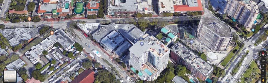
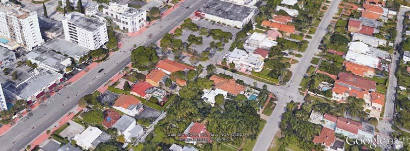
37 Understanding Scale Dolphin Mall footprint overlaid on downtown Coral Gables Approx. 0.5 mile


38 Understanding Scale Metropica development at Sawgrass Mills Mall


39 Understanding Density East West Corridor Land Use Scenario & Visioning Planning #MiamiSMARTPlan


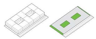
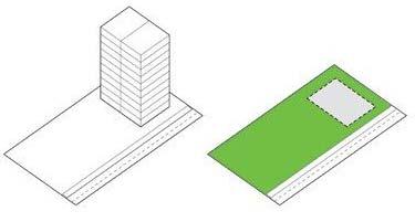
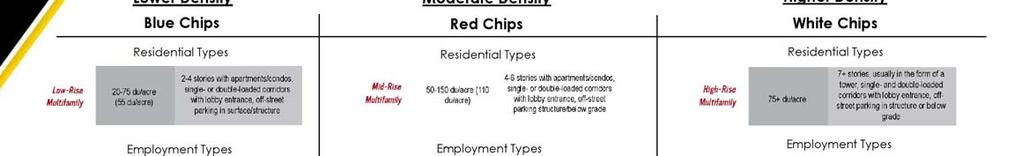
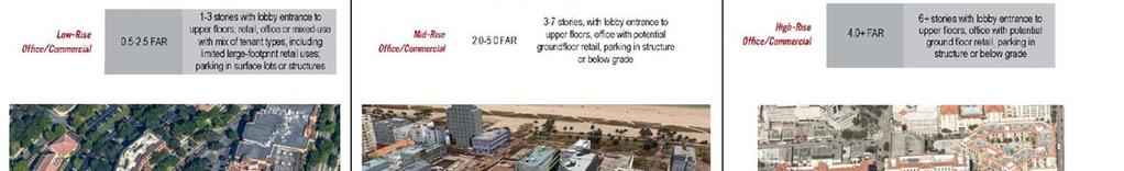
40 Understanding Density 45+ STORIES = 150 DU/ACRE 3 STORIES = 150 DU/ACRE
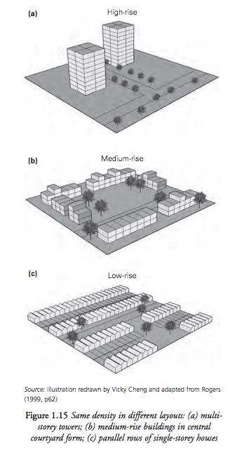
41 Understanding Density 30 DU/ACRE 30 DU/ACRE 30 DU/ACRE

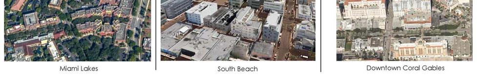
42 TOD Examples in Miami-Dade County Kendall (Dadeland South Metrorail)


43 TOD Examples in Miami-Dade County Jackson Memorial Hospital (Civic Center Metrorail)


44 TOD Examples in Miami-Dade County Shops at Merrick Park Area (Douglas Road Metrorail)


45 TOD Examples in Miami-Dade County Coconut Grove

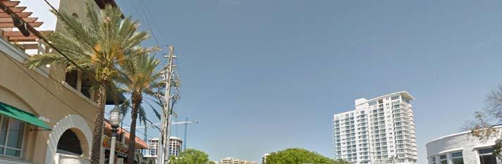
46 TOD Examples in Miami-Dade County South Beach
47 Live Polling Round Two
 to 5 (high) 1. 2. 3. 4. 5. 0% 0% 0% 0% 0% (1) (2) (3) (4) (5)")
48 Visual Preference Survey Please rank this image based on your preference on a scale of 1 (low) to 5 (high) % 0% 0% 0% 0% (1) (2) (3) (4) (5)
 to 5 (high) 1. 2. 3. 4. 5. 0% 0% 0% 0% 0% (1) (2) (3) (4) (5)")
49 Visual Preference Survey Please rank this image based on your preference on a scale of 1 (low) to 5 (high) % 0% 0% 0% 0% (1) (2) (3) (4) (5)
 to 5 (high) 1. 2. 3. 4. 5. 0% 0% 0% 0% 0% (1) (2) (3) (4) (5)")
50 Visual Preference Survey Please rank this image based on your preference on a scale of 1 (low) to 5 (high) % 0% 0% 0% 0% (1) (2) (3) (4) (5)
51 Visual Preference Survey Please rank this image based on your preference on a scale of 1 (low) to 5 (high) % 0% 0% 0% 0% (1) (2) (3) (4) (5)
 to 5 (high) 1. 2. 3. 4. 5. 0% 0% 0% 0% 0% (1) (2) (3) (4) (5)")
52 Visual Preference Survey Please rank this image based on your preference on a scale of 1 (low) to 5 (high) % 0% 0% 0% 0% (1) (2) (3) (4) (5)
 to 5 (high) 1. 2. 3. 4. 5. 0% 0% 0% 0% 0% (1) (2) (3) (4) (5)")
53 Visual Preference Survey Please rank this image based on your preference on a scale of 1 (low) to 5 (high) % 0% 0% 0% 0% (1) (2) (3) (4) (5)
 to 5 (high) 1. 2. 3. 4. 5. 0% 0% 0% 0% 0% (1) (2) (3) (4) (5)")
54 Visual Preference Survey Please rank this image based on your preference on a scale of 1 (low) to 5 (high) % 0% 0% 0% 0% (1) (2) (3) (4) (5)
55 Breakout Exercises Overview

56 Charrette Breakout Exercises Challenges/Opportunities/Liabilities/Assets (COLA) Station Area Identification Land Use Allocation Finalize corridor vision Report out

57 TOD Place Types
58 TOD Station Area Example
59 Study Contacts Wilson Fernandez Miami Dade TPO Project Manager Jack Schnettler Consultant Project Manager Alicia Gonzalez Consultant Public Information Officer Stay Informed! Thank You for joining us today! Your involvement is very important!
Transit / Housing Oriented Redevelopment
 Broward County Urban Planning and Redevelopment Department Kick-Off Meeting October 24, 2007 Transit / Housing Oriented Redevelopment 1 Future Land Use 2 Broward County Charter Voters approved in 1974.
The State Road 7/U.S. 441 Collaborative. 8 th Annual New Partners for Smart Growth Building Safe, Healthy and Livable Communities
 The State Road 7/U.S. 441 Collaborative 8 th Annual New Partners for Smart Growth Building Safe, Healthy and Livable Communities J. Gary Rogers City of Lauderdale Lakes Florida Community Redevelopment
Planning for TOD Implementation at a Corridor Scale
 Planning for TOD Implementation at a Corridor Scale Catherine Cox Blair, Reconnecting America Presentation to DRCOG and the Sustainable Communities Initiative May 14, 2012 What is Reconnecting America?
Transportation Working Team Duane Diggs, Co-Chair (VOICE Buffalo) Kelly Dixon, Co-Chair (GBNRTC) Paul Ray, Facilitator (UB Regional Institute)
 Kelly Dixon, Co-Chair (GBNRTC) Paul Ray, Facilitator (UB Regional Institute)") towards a more sustainable Buffalo Niagara Transportation Working Team Duane Diggs, Co-Chair (VOICE Buffalo) Kelly Dixon, Co-Chair (GBNRTC) Paul Ray, Facilitator (UB Regional Institute) Agenda Welcome,
towards a more sustainable Buffalo Niagara Transportation Working Team Duane Diggs, Co-Chair (VOICE Buffalo) Kelly Dixon, Co-Chair (GBNRTC) Paul Ray, Facilitator (UB Regional Institute) Agenda Welcome,
South Corridor Rapid Transit Project Public Kick-Off Meeting
 Department of Transportation and Public Works (DTPW) South Corridor Rapid Transit Project Public Kick-Off Meeting Wednesday, May 31, 2017 Please use same 4 pictures from Fact Sheet 1 Meeting Overview Miami-Dade
Hillsborough County MPO Transit Study. Citizens Team Workshop Wednesday, February 28 th, 2006 Hillsborough Community College - Brandon
 Hillsborough County MPO Transit Study Citizens Team Workshop Wednesday, February 28 th, 2006 Hillsborough Community College - Brandon What is the MPO Transit Study? An effort to look at the full range
Tony Garcia, City-County Planning Commission & Beth Alden, Hillsborough MPO
 Tony Garcia, City-County Planning Commission & Beth Alden, Hillsborough MPO TOD Defined A compact neighborhood with housing, jobs and neighborhood services within easy walking distance of a transit station
Transit Planning And Redevelopment
 Transit Planning And Redevelopment Strategies for Cities in the Region February 23, 2010 Treasure Coast Regional Planning Council Stuart, 1988 NMB, 1999 Stuart, 1998 South Dade, 2002 SFECC Service Concepts
Atlanta BeltLine. Subareas 9 & 10. Master Plan Updates. March 26, Washington Park Jamboree 1
 Atlanta BeltLine Subareas 9 & 10 Master Plan Updates March 26, 2018 Washington Park Jamboree 1 22 miles, connecting 45 neighborhoods 22 MILES of transit 46 MILES of streetscapes and complete streets 33
40 Years of Smart Growth Arlington County s Experience with Transit Oriented Development in the Rosslyn-Ballston Metro Corridor
 40 Years of Smart Growth Arlington County s Experience with Transit Oriented Development in the Rosslyn-Ballston Metro Corridor A presentation by the Arlington County Department of Community Planning,
Subregion 4 Central Avenue-Metro Blue Line Corridor Transit-Oriented Development (TOD) Implementation Project. Community Meeting April 27, 2011
 Implementation Project. Community Meeting April 27, 2011") Subregion 4 Central Avenue-Metro Blue Line Corridor Transit-Oriented Development (TOD) Implementation Project Community Meeting April 27, 2011 Overview Introduction to Subregion 4 TOD Implementation Program
Subregion 4 Central Avenue-Metro Blue Line Corridor Transit-Oriented Development (TOD) Implementation Project Community Meeting April 27, 2011 Overview Introduction to Subregion 4 TOD Implementation Program
40 Years of Smart Growth Arlington County s Experience with Transit Oriented Development in the Rosslyn-Ballston Metro Corridor
 40 Years of Smart Growth Arlington County s Experience with Transit Oriented Development in the Rosslyn-Ballston Metro Corridor A presentation by the Arlington County Department of Community Planning,
Corridor-Level Approaches to Creating Transit-Oriented Districts
 Corridor-Level Approaches to Creating Transit-Oriented Districts Dena Belzer Strategic Economics and Center for Transit-Oriented Development August 2011 5-year old partnership dedicated to improving practice
Planning for TOD Implementation at a Corridor Scale
 Planning for TOD Implementation at a Corridor Scale Bill Sadler, Reconnecting America Presentation to Gold Line Corridor Working Group July 2, 2013 What is Reconnecting America? Reconnecting America is
ORANGE COUNTY IMPLEMENTING THE FOUR C s
 ORANGE COUNTY IMPLEMENTING THE FOUR C s East Central Florida Corridor Task Force O R A N G E COUN TY P LA N N I N G DIVISION C O M M U N I T Y, E N V I R O N M E N T A L A N D D E V E L O P M E N T S E
Chapter 1: Introduction
 Chapter 1: Introduction The Penn Avenue Community Works Corridor Vision and Implementation Framework presents an integrated communitybased vision and a coordinated, long-term implementation framework for
Three Decades of Smart Growth: Arlington s Urban Village
 Three Decades of Smart Growth: Arlington s Urban Village An Overview Christopher Zimmerman Arlington County Board January 26, 2006 Arlington, Virginia 3 1 Arlington Today Population ~200,000 Jobs >200,000
Atlanta BeltLine Corridor Environmental Study. Scoping Meeting August 2008
 Atlanta BeltLine Corridor Environmental Study Scoping Meeting August 2008 What Will We Be Discussing Today? Study Overview - How Did We Get Here? - What Is the Study About? - Who Is Involved? - Where Is
Northwest commuter rail station US 36 BRT. Westminster Station
 Northwest commuter rail station Westminster Station US 36 BRT Westminster Center US 36 & Church Ranch Broomfield Flatiron/96 th St. US 36 & McCaslin Table Mesa Boulder Junction 13-month effort that will
Coliseum Station Area Area Redevelopment Plan. Public Engagement #1 June 12, 2017
 Coliseum Station Area Area Redevelopment Plan Public Engagement #1 June 12, 2017 Welcome Engagement Purpose Introduce the project Share information Gather input Project Updates & Newsletter edmonton.ca/coliseumplan
REVIEW AND EVALUATION OF REGIONAL LAND USE
 REVIEW AND EVALUATION OF REGIONAL LAND USE AND TRANSPORTATION SCENARIOS #220831 Environmental Justice Task Force October 7, 2014 VISION 2050 Process Development of Guiding Vision for Land Use and Transportation
Building out the Regional Growth Strategy in Surrey: a Strong Centre & a Connected Transit City
 Building out the Regional Growth Strategy in Surrey: a Strong Centre & a Connected Transit City Surrey in the Metro Vancouver Region Regional Growth Strategy identifies Surrey as a major provider of housing
City of Fort Lauderdale UPTOWN URBAN VILLAGE. Public Workshop December 7, 2016
 Public Workshop December 7, 2016 Workshop Agenda Introductions Project Presentation o o o History Project Scope/Timeline Character of Study Area o o o o Land Use Public Realm/Pedestrian Mobility Multimodal
Crofton Manor 2803 West 41st Avenue WHAT WE HEARD. Public Consultation: Phase 1
 Crofton Manor 2803 West 41st Avenue WHAT WE HEARD Public Consultation: Phase 1 Background CROFTON MANOR What s Happening The City of Vancouver is undertaking a planning and public engagement process to
The Need to Develop a Transit Ready Community
 Evaluation & Appraisal Report (EAR) Major Issue # 6 The Need to Develop a Transit Ready Community July 3, 2007 EAR Major Issue # 6 Transit Ready Existing Comp Plan policies apply only to Indiantown Road:
Gratigny Parkway East Extension Project Development & Environment (PD&E) Study
 Study") Gratigny Parkway East Extension Project Development & Environment (PD&E) Study Session 4: Presentation of Charrette Results December 8, 2010 MDX Work Program #: 92407 ETDM#: 11500 Project Location & Description
Gratigny Parkway East Extension Project Development & Environment (PD&E) Study Session 4: Presentation of Charrette Results December 8, 2010 MDX Work Program #: 92407 ETDM#: 11500 Project Location & Description
Silver Line CPAM UPDATE. Transportation and Land Use Committee October 14, 2016
 Silver Line CPAM UPDATE Transportation and Land Use Committee October 14, 2016 Purpose Recap Project History and Map Changes Provide Overview of CPAM Components Discuss Transportation Impacts Discuss Fiscal
Definitions. Average Daily Traffic Demand (ADT): The actual number or projected number of cars that pass a point in a 24-hour period.
: The actual number or projected number of cars that pass a point in a 24-hour period.") Definitions Access Management: A combination of physical techniques and transportation policies used to control the flow of traffic between roads and the surrounding lands. Alternative City Form Scenarios:
Definitions Access Management: A combination of physical techniques and transportation policies used to control the flow of traffic between roads and the surrounding lands. Alternative City Form Scenarios:
MORRISVILLE TRANSPORTATION PLAN TOWN COUNCIL PRESENTATION AUGUST 22, 2017
 TOWN COUNCIL PRESENTATION AUGUST 22, 2017 SCENARIO PLANNING CORRIDORS Town Hall Drive Baseline + 2 McCrimmon Parkway Baseline + 2 NC 54 Baseline + 2 7 subregion model runs determining carrying capacity
ARLINGTON COUNTY, VIRGINIA
 ARLINGTON COUNTY, VIRGINIA County Board Agenda Item Meeting October 15, 2005 DATE: September 28, 2005 SUBJECT: Request to Advertise the adoption of the 2005 Clarendon Sector Plan C. M. RECOMMENDATION:
EAR WORKSHOP FOR PALM BEACH COUNTY LOCAL GOVERNMENTS APRIL 2010 TREASURE COAST REGIONAL PLANNING COUNCIL
 EAR WORKSHOP FOR PALM BEACH COUNTY LOCAL GOVERNMENTS APRIL 2010 TREASURE COAST REGIONAL PLANNING COUNCIL Why Should I Care about Transportation & Land Use? Congestion or Mobility Pick One!! Congestion
Design Fort Ord. welcome why we are here what happened this week design guidelines: ideas so far 2/12/2015. Regional Urban Design Guidelines (RUDG)
") Design Fort Ord Regional Urban Design Guidelines (RUDG) Welcome Back! Strategic Economics Alta Planning + Design National Charrette Institute Helix Environmental Planning Jeff Speck & Peter Katz Civitas
Design Fort Ord Regional Urban Design Guidelines (RUDG) Welcome Back! Strategic Economics Alta Planning + Design National Charrette Institute Helix Environmental Planning Jeff Speck & Peter Katz Civitas
SUBJECT: LOCAL GOVERNMENT COMPREHENSIVE PLAN PROPOSED AND ADOPTED AMENDMENT CONSENT AGENDA
 MEMORANDUM AGENDA ITEM #IV.C DATE: APRIL 15, 2019 TO: FROM: COUNCIL MEMBERS STAFF SUBJECT: LOCAL GOVERNMENT COMPREHENSIVE PLAN PROPOSED AND ADOPTED AMENDMENT CONSENT AGENDA Pursuant to the 1974 Interlocal
City of Long Beach. creating vibrant and exciting places
 City of Long Beach creating vibrant and exciting places Land Use Element Urban Design Element Overview of the two draft General Plan elements Discuss areas of change Economic goals of the plans Case study
Downtown Elkton Station Area Plan, Elkton, MD. Difficult enough to get support for new starts challenge to fund Houston transit
 Difficult enough to get support for new starts challenge to fund Houston transit More difficult to build Community Support for dense development at station areas Major Concerns: Traffic, Property values,
DELIVERING ON THE TRANSIT PROMISE
 DELIVERING ON THE TRANSIT PROMISE Dena Belzer October 6, 2015 Presentation Overview 1. Puget Sound As a Transit Region: Putting SeaTac in Context 2. Starting at the Beginning: How Does TOD Work? 3. Strategies
Chapter 1.0 Introduction
 Chapter 1.0 Introduction 1.1 Background The North Metro commuter rail line is part of the RTD FasTracks regional transit system expansion program to build more than 100 miles of rail transit throughout
BeltLine Corridor Environmental Study
 BeltLine Corridor Environmental Study Joint TAC and SAC Meeting December 8, 2008 What We Will Discuss Today Outreach and Agency Coordination Scoping Results Existing Conditions Historical and Archeological
ATTACHMENT A. Definition of Activity Centers
 ATTACHMENT A Definition of Activity Centers Lynnwood Link Extension DEFINITION OF ACTIVITY CENTERS FTA definition: When performing an assessment of Land Use and Economic Development Effects, the FTA New
International Blvd. TOD Plan Public Workshop #1
 International Blvd. TOD Plan Public Workshop #1 Add photos or project images September 21 and 22, 2010 Workshop Purpose Introduce the public to the Project Review and discuss the existing conditions analysis
12/9/2013. HOLLYWOOD/PINES CORRIDOR PROJECT AMPO 2013 Annual Conference October 24, Our Perspective. Broward.
 HOLLYWOOD/PINES CORRIDOR PROJECT AMPO 2013 Annual Conference October 24, 2013 Our Perspective Broward Fort Lauderdale 1 Broward Metropolitan Planning Organization Fort Lauderdale Fort Lauderdale Skyline
Atlanta BeltLine Subarea 3 Master Plan Update
 Atlanta BeltLine Subarea 3 Master Plan Update April 14, 2018 Workshop Meeting 1 22 miles, connecting 45 neighborhoods 22 MILES of transit 46 MILES of streetscapes and complete streets 33 MILES of urban
U T D N o r t h C a m p u s T O D and D o w n t o w n D e n t o n T O D
 U n i v e r s i t y o f T e x a s a t D a l l a s C i t y o f R i c h a r d s o n U T D N o r t h C a m p u s T O D and D o w n t o w n D e n t o n T O D Rick Leisner, AICP Assistant Director of Development
Edmonton s Transit Oriented Development Journey
 Edmonton s Transit Oriented Development Journey Auckland Design Office Lunchtime Learning July 2018 Tom Young, MCIP, MCP NZ Group Manager, Urban Planning & Environmental Services tom.young@stantec.com
CHAPTER 7: Transportation, Mobility and Circulation
 AGLE AREA COMMUNITY Plan CHAPTER 7 CHAPTER 7: Transportation, Mobility and Circulation Transportation, Mobility and Circulation The purpose of the Transportation, Mobility and Circulation Chapter is to
TOD 101 CREATING LIVABLE COMMUNITIES WITH TRANSIT
 1 CREATING LIVABLE COMMUNITIES WITH TRANSIT What are transit Centered Communities? Benefits of Partnerships to Support and Implement What You Will Learn Portland s Pearl District Your Trainers Today Catherine
TRANSIT ORIENTED DEVELOPMENT PINELLAS COUNTY MPO LIVABLE COMMUNITIES INITIATIVE PINELLAS COUNTY COMPREHENSIVE PLAN AMENDMENTS
 PINELLAS COUNTY MPO LIVABLE COMMUNITIES INITIATIVE MODEL LAND DEVELOPMENT CODE TRANSIT ORIENTED DEVELOPMENT PINELLAS COUNTY COMPREHENSIVE PLAN AMENDMENTS MPO Livable Communities Initiative Goal: Improve
Glenborough at Easton Land Use Master Plan
 Vision Statement Sunrise Blvd. Hazel Ave. Prairie City Rd. Gencorp Property Lincoln Regional Airport 1.0 VISION STATEMENT The identifies City of the principles, goals, policies, and standards Lincoln that
WELCOME and introduction
 1 WELCOME and introduction Mobility Hub Locations within Burlington STUDY OVERVIEW STUDY OBJECTIVES The City of Burlington is developing four Area Specific Plans, one for each of Burlington s Mobility
BeltLine Corridor Environmental Study
 BeltLine Corridor Environmental Study Citywide Conversation on Transit and Trails April 2, 2009 Agenda & Introductions Introductions Environmental Study Process Overview of the BeltLine Project BeltLine
GAINING LEVERAGE through
 GAINING LEVERAGE through FTA s New Starts Land Use Criteria Brigid Hynes-Cherin Associate Administrator FTA Office of Planning and Environment Evaluation and Rating of Transit Supportive Land Use Agenda
FUNDING CORRIDOR REVITALIZATION
 FUNDING CORRIDOR REVITALIZATION Integrated corridor planning for the 21 st Century America Planning Association Annual Conference Atlanta, GA April 27, 2014 Mariia Zimmerman, MZ Strategies, LLC mariia@mzstrategies.com
ForwardDallas! Comprehensive Plan. City Council Briefing February 15, 2006
 ForwardDallas! Comprehensive Plan City Council Briefing February 15, 2006 Purpose Brief City Council on the preliminary products of the Forward Dallas! Comprehensive Plan 2 Where we are in the process
Pace University Land Use and Sustainable Development Conference Tensions and Opportunities in Urban Revitalization
 Pace University Land Use and Sustainable Development Conference Tensions and Opportunities in Urban Revitalization Ken Schwartz, Principal, VHB December 6, 1013 Pace University Land Use and Sustainable
Isabel Neighborhood Plan: Alternatives
 Isabel Neighborhood Plan: Alternatives Presented by: Lori Parks, Associate Planner February 2, 2015 Agenda 1. Background on BART to Livermore 2. Isabel Neighborhood Plan 3. Alternative Scenarios 4. General
St. Louis Park Wooddale LRT Station Site development guidelines
 St. Louis Park Wooddale LRT Station Site development guidelines November 2013 OVERVIEW St. Louis Park s convenient location as a neighbor to Minneapolis means you re only minutes away from some of the
East Central Area Plan
 East Central Area Plan Steering Committee Meeting January 10 th, 2019 Tears-McFarlane House Community Room East Central Area Plan Steering Committee Meeting January 10 th, 2019 CHUN Tears-McFarlane House
TOWN OF NEW CASTLE - Master Plan Update
 Our Presentation Today (1) Recap the Master Planning Process To Date (2) Present the Outline of the Master Planning Work Plan (3) Present the Calendar for the Master Plan (4) Outline the scope of a Downtown
City of Lake Mary, Florida. Evolution of a Historic Downtown with Transit Oriented Development Strategies
 City of Lake Mary, Florida Evolution of a Historic Downtown with Transit Oriented Development Strategies What is Transit Oriented Development? Walkable villages located at and around transit stations in
Wasatch CHOICE for 2040
 Wasatch CHOICE for 2040 Economic Opportunities We Can Choose a Better Future We enjoy an unparalleled quality of life along the Wasatch Front. People from all over the world are drawn to our stunning scenery,
COMMUNITY OPEN HOUSE. March 28, 2012
 COMMUNITY OPEN HOUSE March 28, 2012 THE CASE FOR URBAN INVESTMENT One of the best things that cities can do to create jobs especially in the private sector is to improve the quality of life of their inhabitants.
Welcome & Introductions
 Charrette Week Report Back - Thursday Evening April 25, 2013 Welcome & Introductions A New Master Plan Land Use and Circulation Putting data and information to work to create solutions for the master plan
Public Open House #1
 Public Open House #1 TONIGHT S AGENDA Welcome Project Overview The Big Picture The Station Area The Analysis Thoughts about Future Change Breakout Group Discussions Summation / Next Steps Project Overview
Status Report: MD 355 Project
 Status Report: MD 355 Project OCTOBER 2006 M-NCPPC MONTGOMERY COUNTY PLANNING DEPARTMENT Summary of Community Comments, and break to the Results of the MD 355 Participation Session Brookside Gardens -
Gold Line Bus Rapid Transit Transit Oriented Development (BRTOD) Helmo Station Area Plan
 Helmo Station Area Plan") Appendix F Gold Line Bus Rapid Transit Transit Oriented Development (BRTOD) Helmo Station Area Plan Introduction and Purpose of the Plan The Gold Line Bus Rapid Transit facility is an eleven-mile dedicated
Appendix F Gold Line Bus Rapid Transit Transit Oriented Development (BRTOD) Helmo Station Area Plan Introduction and Purpose of the Plan The Gold Line Bus Rapid Transit facility is an eleven-mile dedicated
What Pioneer Grove Will Look Like?
 The City of Deerfield Beach has embarked on a journey to create a new town center within the old heart of Deerfield Beach. The new town center is known as Pioneer Grove. Pioneer Grove will be Everybody
New Partners for Smart Growth Conference February 5, 2010
 Dan Stroh, Planning Director City of Bellevue Planning and Community Development Bellevue, WA New Partners for Smart Growth Conference February 5, 2010 Summary of Project Long-range plan update for Bel-Red
Sustainability, Health, Safety, Recreation & Open Space Working Group August 3, 2017
 Sustainability, Health, Safety, Recreation & Open Space Working Group August 3, 2017 DOWNTOWN OAKLAND SPECIFIC PLAN WELCOME Sustainability, Health, Safety, Recreation & Open Space Working Group Social
CHAPTER 3 VISION, GOALS, & PLANNING PRINCIPLES. City of Greensburg Comprehensive Plan. Introduction. Vision Statement. Growth Management Goals.
 CHAPTER 3 VISION, GOALS, & PLANNING PRINCIPLES Introduction The Greensburg Comprehensive Plan is intended as a working community document. A combination of long and short-term goals, this document is intended
dr. robert paterson Spring 2016
 sustainable land use planning community and regional planning dr. robert paterson Spring 2016 Contemporary land use planning requires an analysis and understanding of physical and social demographics,
CHARLES PUTMAN CHARLES PUTMAN AND ASSOCIATES, INC
 MEMORANDUM CHARLES PUTMAN & ASSOCIATES, INC. LAND DEVELOPMENT CONSULTANTS PLANNING ZONING PERMITTING 4722 NW Boca Raton Boulevard, Suite C-106 Boca Raton, Florida 33431 Phone: 561/994-6411 FAX: 561/994-0447
SOUTH FLORIDA TOD GRANT UPDATE
 Palm Beach Transportation Planning Agency October 2018 SOUTH FLORIDA TOD GRANT UPDATE Presented by Treasure Coast Regional Planning Council in partnership with SFRTA & SFRPC What is Transit Oriented Development
Envision Front Royal Workshop 1 of 2
 Envision Front Royal Workshop 1 of 2 September 12, 2013 Summary The Envision Front Royal project held the first of two public workshops on September 12, 2013. The purpose of the workshop was to evaluate
1.3 TRANSIT VISION 2040 FROM VISION TO ACTION THEME 1: PUTTING TRANSIT AT THE CENTRE OF COMMUNITIES. Fully integrate transit with community planning
 TRANSIT VISION 2040 FROM VISION TO ACTION TRANSIT VISION 2040 defines a future in which public transit maximizes its contribution to quality of life with benefits that support a vibrant and equitable society,
Kensington Center. Public Meeting # Transit-Oriented Development, Town of Berlin, CT
 Kensington Center Public Meeting #1 10.27.16 Transit-Oriented Development, Town of Berlin, CT CivicMoxie 2016 What is Transit-Oriented Development Definition: Transit-Oriented Development (TOD) = is an
Planning for TOD Implementation at a Corridor Scale
 Planning for TOD Implementation at a Corridor Scale Catherine Cox Blair, Reconnecting America Presentation to Northwest Corridor Working Group November 6, 2013 What is Reconnecting America? Reconnecting
Information Session July 25, 2018
 Concord Pike (US 202) Master Plan Information Session July 25, 2018 1 Concord Pike (US 202) Master Plan 2018 Project Partners Wilmington Area Planning Council Delaware Department of Transportation New
THE NEIGHBORHOOD TODAY
 THE NEIGHBORHOOD TODAY CORE AREA VISION How are we Good Urbanism A Site s DNA thinking about Elements of great Unique elements urban communities embedded in a place the site and design? ELEMENTS LIKE:
Public input has been an important part of the plan development process.
 Lakewood s Comprehensive Plan recognizes that transportation helps shape the community, and that the way the community provides for the safe and efficient movement of people affects the character of the
13 THORNHILL YONGE STREET STUDY IMPLEMENTATION CITY OF VAUGHAN OPA 669 AND TOWN OF MARKHAM OPA 154
 13 THORNHILL YONGE STREET STUDY IMPLEMENTATION CITY OF VAUGHAN OPA 669 AND TOWN OF MARKHAM OPA 154 The Planning and Economic Development Committee recommends the adoption of the recommendations contained
Palm Beach County (University Drive Removal) and Broward County (Transportation Element) Remedial Amendments
 and Broward County (Transportation Element) Remedial Amendments") SR 7/US 441 Transit-Supportive Land Use Planning and Urban Design Assistance (SR 7 Study) Focus TCRPC: Develop detailed analysis of land uses, development regulations, and community visioning all relative
SR 7/US 441 Transit-Supportive Land Use Planning and Urban Design Assistance (SR 7 Study) Focus TCRPC: Develop detailed analysis of land uses, development regulations, and community visioning all relative
CITY OF UNION CITY MINUTES GENERAL PLAN ADVISORY COMMITTEE
 CITY OF UNION CITY MINUTES GENERAL PLAN ADVISORY COMMITTEE WEDNESDAY, MARCH 4, 2015, 6:30 P.M. IN THE CITY COUNCIL CONFERENCE ROOM OF CITY HALL 34009 ALVARADO-NILES BLVD., UNION CITY, CALIFORNIA Attachment
South Fulton Parkway Transit Feasibility Study
 South Fulton Parkway Transit Feasibility Study Study Purpose To conduct a high level assessment of potential transit improvements in the South Fulton Parkway Corridor through the evaluation of various
Metro. Activity Center Design Guidelines. Recommendations For Developing Focused, Mixed-Use Commercial/Residential Centers
 Metro Activity Center Design Guidelines Recommendations For Developing Focused, Mixed-Use Commercial/Residential Centers Metro Activity Centers What is a MAC? Legacy, the adopted guide for the future growth
Transit-Oriented Mixed Use Zoning in Montgomery County, Maryland
 Transit-Oriented Mixed Use Zoning in Montgomery County, Maryland Nkosi Yearwood Community-Based Planning Division Montgomery County Planning Department Rail Volution 2007 Miami, Florida The General Plan
Route 110 Alternatives Analysis
 Route 110 Alternatives Analysis Public Meeting #1 December 15, 2014 Source: Town of Babylon Agenda Welcome/Introduction Hon. Antonio A. Martinez Deputy Supervisor, Town of Babylon Update on East Farmingdale
RESOLUTION NO. R Refining the route, profile and stations for the Downtown Redmond Link Extension
 RESOLUTION NO. R2018-32 Refining the route, profile and stations for the Downtown Redmond Link Extension MEETING: DATE: TYPE OF ACTION: STAFF CONTACT: Capital Committee Board PROPOSED ACTION 09/13/2018
178 Carruthers Properties Inc.
 178 Carruthers Properties Inc. Planning Rationale for 178 Carruthers Avenue Site Plan Control Application June 2014 Table of Contents 1.0 Introduction 2.0 Overview of Subject Property 3.0 Current Zoning
Tysons Circulator Study: Process and Preliminary Results Summary. March 2012
 Tysons Circulator Study: Process and Preliminary Results Summary March 2012 Background: 1. The Comprehensive Plan for the Tysons Corner Urban Center calls for a System of Circulators in Tysons Corner to:
Point A Point B Point C Point D. City of Hapeville Public Meeting July 25, 2017
 City of Hapeville Public Meeting July 25, 2017 Fulton County Transit Master Plan Overview Following last year s ¾-cent TSPLOST effort, the Mayors of the 14 Cities outside of Atlanta and the Fulton County
WATERLOO STATE SIGNIFICANT PRECINCT SUMMARY OF STUDIES
 WATERLOO STATE SIGNIFICANT PRECINCT SUMMARY OF STUDIES Technical studies will be undertaken to inform the master planning process for the Waterloo precinct to develop a Precinct Proposal to redevelop the
PD&E STUDY SR 9/I-95 FROM SOUTH OF SR 870/COMMERCIAL BOULEVARD TO NORTH OF CYPRESS CREEK ROAD FM # ETDM 14222
 PD&E STUDY SR 870/COMMERCIAL BOULEVARD TO NORTH OF CYPRESS CREEK ROAD FM # 435808-1-22-02 ETDM 14222 WELCOME TO THE KICK-OFF MEETING May 24, 2016 1 1 2 3 4 5 6 PLANNING PROJECT DEVELOPMENT AND ENVIRONMENT
Robbinsdale LRT Station. CDI Development Guidelines. August Overview
 Robbinsdale LRT Station August 2018 Overview The City of Robbinsdale may have the coolest opportunity site along the 13 mile stretch of the Bottineau LRT corridor / Blue Line extension. Located a block
Land Use & Infrastructure Master Plan City of Orlando Council Work Session
 DOWNTOWN ORLANDO Community Venues Land Use & Infrastructure Master Plan City of Orlando Council Work Session Prepared By: Glatting Jackson Kercher Anglin Lopez Rinehart, Inc. May 1, 2006 AGENDA Community
Don Mills Crossing Study and Celestica Lands Development Application Community Meeting, Open House, and Breakout Discussions
 Consultation Summary Don Mills Crossing Study and Celestica Lands Development Application Community Meeting, Open House, and Breakout Discussions This report is not intended to provide a verbatim transcript
Streets, Connectivity & Built Environment Working Group August 2, 2017
 Streets, Connectivity & Built Environment Working Group August 2, 2017 DOWNTOWN OAKLAND SPECIFIC PLAN WELCOME Streets, Connectivity & Built Environment Working Group Social Equity Meeting August 2, 2017
Peoria Avenue BRT Land Use Framework
 Planning Urban Design Landscape Architecture Historic Preservation Community Engagement Peoria Avenue BRT Land Use Framework Public Workshop Presentation Central Center Partners: Duncan Associates CLUE
Preliminary Recommendations Tk Takoma/Langley Crossroads Sector Plan
 Preliminary Recommendations Tk Takoma/Langley Crossroads Sector Plan Vision is to achieve a Transit Oriented, pedestrian friendly Community that Celebrates and builds upon the cultural Diversity of the
Citizen Comment Staff Response Staff Recommended Revision Planning Committee
 Citizen Comment Staff Response Staff Recommended Revision Planning Committee Area No. 1: Owner desires retail land uses. Area No. 1a: Owner of two small parcels adjacent to Area No. 1 desires retail land
Eastern Terminus TECHNICAL MEMORANDUM CENTRAL BROWARD EAST-WEST TRANSIT ANALYSIS BROWARD COUNTY, FLORIDA
 Eastern Terminus TECHNICAL MEMORANDUM CENTRAL BROWARD EAST-WEST TRANSIT ANALYSIS BROWARD COUNTY, FLORIDA FINANCIAL PROJECT ID NUMBER 411189-2-22-01 FLORIDA DEPARTMENT OF TRANSPORTATION DISTRICT 4 Prepared