Making the Land Use, Transportation, Air Quality Connection
|
|
|
- Joleen Gibbs
- 5 years ago
- Views:
Transcription
1


2 Special Thanks To Our Generous Sponsor

3 What Happened To Harbor Drive and the Mt. Hood Freeway? Andy Cotugno Metro Policy Advisor

4 180 days of air quality violations

5 Gas Crisis

6 Making The Pacific the Land Northwest Use, Transportation,


7 The Oregon Story "There is a shameless threat to our environment and to the whole quality of life: unfettered despoiling of the land. Sagebrush subdivisions, coastal 'condomania... Governor Tom McCall


8 The Oregon Story...and the ravenous rampage of suburbia in the Willamette Valley all threaten to mock Oregon's status as the environmental model for the nation. Tom McCall s address to the Legislature, January 8, 1973


9 Senate Bill 100 Legislature adopts pioneering 1973 statewide planning program to limit sprawl and protect forest and farms Legislation requires local plans to meet statewide goals; creates LCDC Urbanization now focused inside urban growth boundaries
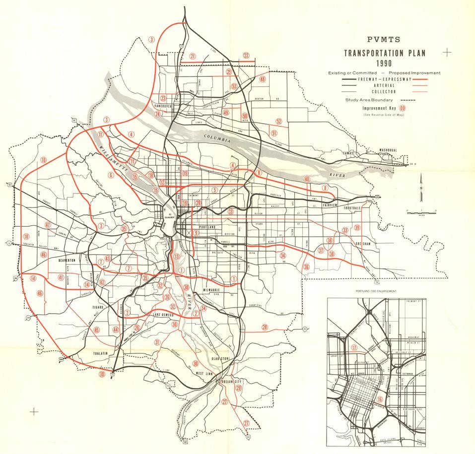
10 Making Oregon the Land Land Use, Transportation, Program State Goals & Regulations Goal 1 Citizen Involvement Goal 2 Planning Process Goal 3 Agricultural Lands Goal 4 Forest Lands Goal 5 Natural Resources Goal 6 Air/Water Quality Goal 7 Natural Disasters & Hazards Goal 8 Recreation Goal 9 Economic Development Goal 10 Housing Goal 11 Public Facilities Goal 12 Transportation Goal 13 Energy Conservation Goal 14 Urban Growth Boundary Goal 15 Willamette River Greenway Goal 16 Estuarine Resources Goal 17 Coastal Shorelands Goal 18 Beaches and Dunes Goal 19 Ocean Resources Metro Regional Framework Plan 2040 Growth Concept Urban Growth Boundary Regional Transportation Plan Riparian Setback Regulations Local Comprehensive Plan Compliance Cities and Counties Comprehensive Land use Plans Building Permits

11 Downtown in Decline Freeways focusing growth in suburbs Downtown buildings razed to construct more parking lots Urban renewal replaces vibrant neighborhoods with sterile highrise apartments

12 They paved paradise... Plans to expand this parking lot to 10 floors in the heart of downtown...

13 produced community demand for the construction of Pioneer Courthouse Square


14 Highway Revolt Harbor Freeway removed in 1976 to make way for Tom McCall Waterfront Park Mount Hood Freeway withdrawn in favor of light rail transit along the Banfield Shift freeway money to multi-modal projects

15 Harbor Drive pre-1976


16 Portland s Backlash In Portland, a backlash forms against a plan for massive freeway building that is already destroying urban neighborhoods

17 I-5 construction circa 1964

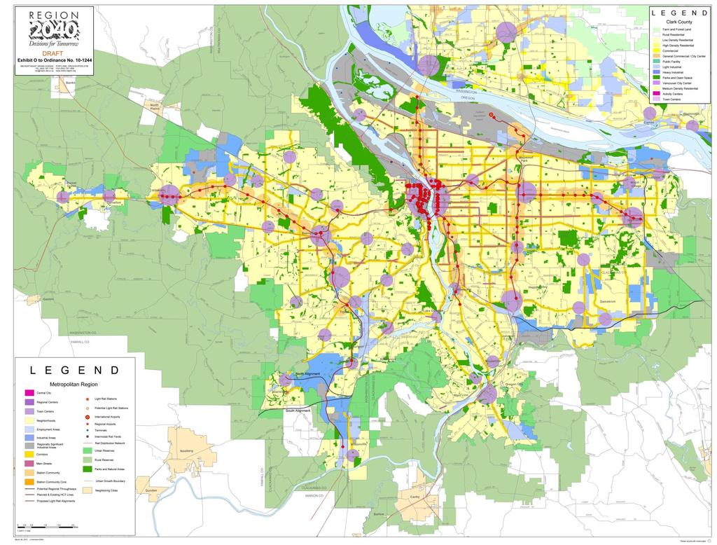
18 Proposed Mt. Hood Freeway through SE Portland

19 Governor s Task Force on Transportation Policy 1975
20
21 Proposed Transit Corridors

22 Opposition Forms Western bypass freeway plan in rapidly growing Washington County

23 Making the Land Use, Transportation,

24 LUTRAQ 1989 Western Bypass proposal frames a new debate on regional growth management 1000 Friends of Oregon proposes LUTRAQ alternative to status quo Linking land use and transportation planning becomes new mandate for regional plans


25 2040 Concepts Base Case Concept A Concept B Concept C 2040 Concept 2040 Growth Concept adopted in 1995

26 2040 Growth Concept 50-year vision for managing region s growth Incorporates best parts of Concepts for Growth options Kicks off a major effort to enact the new regional vision through local plans


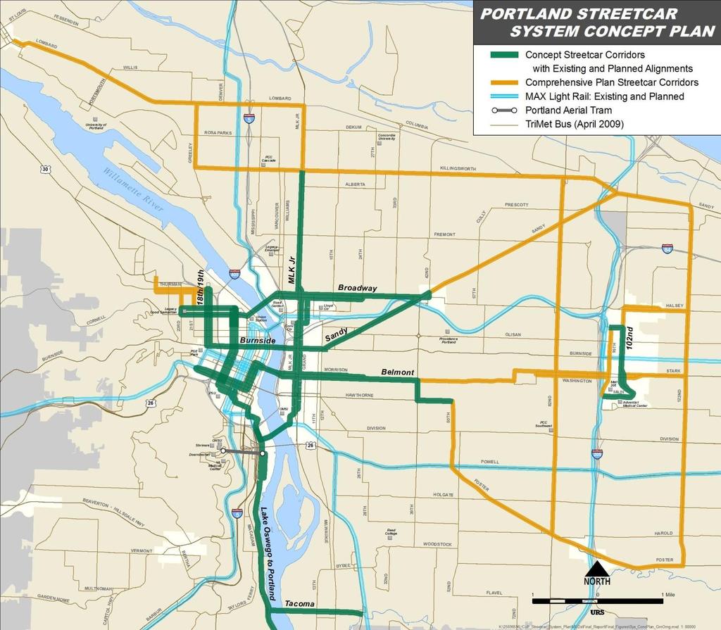
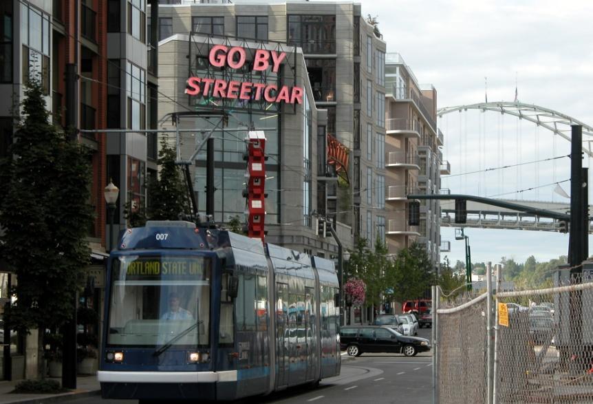
27 2040 Theme: Growth in Centers Compact urban centers built to human scale Mixed housing and commerce served with good transit Focus of civic activities and public services Parking ratios established

28 2040 Theme: Protect Industry Preserve Industrial Lands Maintain freight mobility on highways Ensure quality freight access to ports and industrial areas from region s highway and rail network

29 2040 Theme: Protect Rural Areas Adopt 50-year Rural Reserves Create Green Corridors along rural state highways Mitigate urban overflow on rural routes Maintain rural separation between Metro region and neighbor cities

30 2040 Theme: Nature in the City Network of parks, trails and open spaces Protections for streams and upland natural areas Green Streets - designs that minimize runoff Employ regulatory and acquisition approaches to preservation and enhancement
31

32
33 Two Tracks for Implementation 2035 RTP Investment Strategy Track 1: Mobility Corridors Track 2: Community Building Centered on major travel corridors Focused on place making

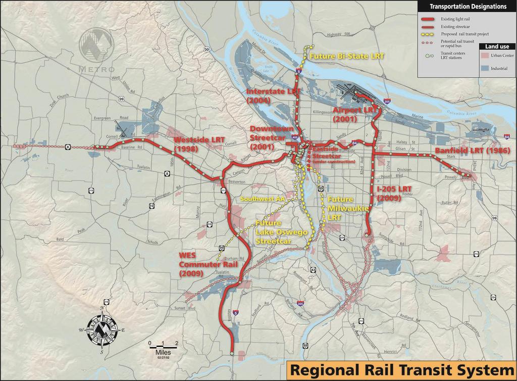
34 To date: 50 miles Light- Rail, 7.3 miles in progress 12 miles of Streetcar 14.7 miles Commuter Rail
35

36 Future Air High Quality Capacity Connection Transit
37


38 Protecting nature Two decades, three regional votes 1995: $136 million bond measure 2006: $227 million bond measure 2013: Five-year, $50 million levy

39 Making the Land Use, On-the-ground Transportation, results 13,000 acres preserved 100 miles of river and stream banks protected 2 million trees and shrubs planted 3 major nature parks opened Hundreds of community projects supported

40 Within the UGB 22,000 acres of Metro s Bond Acquisitions. Public Parks, and public Open Spaces have been protected
41 Within the UGB Title 13 (through regulation) protects 27,300 acres of Riparian Habitat outside of our Public parks and open spaces
42 Unlinked Trips/Service District Population Making the Land Use, Transportation, 70 Rides per Resident Service Area Note: Data for Minneapolis/St. Paul, Phoenix and Seattle contain multiple reporting agencies National Transit Database Released September 2012

43 more bikes
44 VMT per Capita Portland, OR Only Portland-Vancouver U.S. National Average
 regional planning entities, local governments, the private sector, and the public.")


45 Million Metric Tons of Greenhouse Gases (CO2e) Source data: Oregon Global Warming Commission Report to the Legislature: Figure 1: Historical and Projected GHG Emissions Trends ( ) regional planning entities, local governments, the private sector, and the public. Making the Land Use, Transportation, While Oregon is prepared to be in the forefront in addressing climate change, it cannot fac this challenge alone. Limiting the impacts of climate change must ultimately be a global effort, requiring actions from other states, the federal government, other countries, and private Oregon s industry. efforts to reduce emissions Current Business as Usual l ForecastF t Current Business as Usual Trend Gross GhG G Emissions E i s (Most Recent Inventory) o 2050 Goal Emissions Trajectory % below 1990 emission levels 2050 at least 75% below 1990 emission levels

46 Source: GreenSTEP

47 Learn more about Metro at Andrew C. Cotugno Metro
Making the Land Use Light Rail Connection. Andy Cotugno Metro Rail~Volution 2010
 Making the Land Use Light Rail Connection Andy Cotugno Metro Rail~Volution 2010 Making The Pacific the Land Northwest Use, Transportation, The Oregon Story "There is a shameless threat to our environment
Oregon s Planning Program History. Oregon s Planning Program History. Oregon s Planning Program History. Oregon s Planning Program History
 Planning the Oregon Way: Planning 101 for Planners and Permit Technicians Central Oregon Planners Network Meeting June 29, 2016 There is a shameless threat to our environment and to the whole quality of
Land Use Planning in the United States and in Oregon
 Land Use Planning in the United States and in Oregon Dr. Ethan Seltzer Nohad A. Toulan School of Urban Studies and Planning Portland State University Outline Planning in the United States Planning In Oregon
Telling the Oregon Story
 Telling the Oregon Story Our legacy, our future (Title) This presentation is intended as a brief, 20 minute INTRODUCTION to the value of good planning and provides a general background on Oregon s unique
Smart growth on the Oregon Coast: Addressing Impacts of climate change. What I will Cover: Oregon Land Use and OCMP Connection
 Smart growth on the Oregon Coast: Addressing Impacts of climate change Laren Woolley, Panelist Costal Shores Specialist Oregon Coastal Management Program Oregon Department of Land Conservation and Development
Midtown Greenway Land Use and Development Plan Executive Summary
 Midtown Greenway Land Use and Development Plan Executive Summary Introduction The Midtown Greenway Land Use and Development Plan sets policy direction for land use and development in the Midtown Greenway
Benchmark Nonpoint Source Management Approaches In Other States
 Governor s Environmental Advisory Council 2007 Nonpoint Source Pollution Control Initiative Benchmark Nonpoint Source Management Approaches In Other States Governor s Environmental Advisory Council April
Livable Portland. Land Use and Transportation Initiatives
 Livable Portland Land Use and Transportation Initiatives November 2010 Capital Projects 710 NE Holladay Street Portland, OR 97232 503-962-2150 trimet.org Preface At TriMet, we are proud of our contribution
City of Lake Oswego Transportation System Plan Update PLAN AND POLICY REVIEW, PART 2
 City of Lake Oswego Transportation System Plan Update PLAN AND POLICY REVIEW, PART 2 Date: March 7, 2012 Project #: 11187 To: Cc: From: Project: Subject: Project Management Team Transportation System Plan
Integrated Urban Development. April Reflections from the NZPI Study Tour of Portland, Seattle and Vancouver
 Integrated Urban Development April 2009 Reflections from the NZPI Study Tour of Portland, Seattle and Vancouver Integrated Urban Development Urban Growth Management Transportation Transit Orientated Mixed
SUNSET CORRIDOR LAND. The property is now available and ready for corporate utilization, development or investment.
 SUNSET CORRIDOR LAND The property is now available and ready for corporate utilization, development or investment. This 275-acre site is now available and ready to develop. Just off US 26, this west Sunset
Ch. 13 Urbanization. Global urbanizing trends 2/9/2016. Our urbanizing world. Central Case: Managing growth in Portland, Oregon
 Ch. 13 Urbanization Central Case: Managing growth in Portland, Oregon Oregon residents feared sprawling development would ruin their communities Urban Growth Boundaries (UGBs) allow development in urban
SAN RAFAEL GENERAL PLAN 2040 INTRODUCTION AND OVERVIEW
 SAN RAFAEL GENERAL PLAN 2040 INTRODUCTION AND OVERVIEW Steering Committee Presentation February 14, 2018 Purpose of General Plan Guide land use and development decisions Coordinate transportation, infrastructure,
Wasatch CHOICE for 2040
 Wasatch CHOICE for 2040 Economic Opportunities We Can Choose a Better Future We enjoy an unparalleled quality of life along the Wasatch Front. People from all over the world are drawn to our stunning scenery,
Gary & Regional Investment Project. October 27, Creating Tomorrow Today Comprehensive Regional Plan - NIRPC
 Creating Tomorrow Today 2040 Comprehensive Regional Plan Gary & Regional Investment Project October 27, 2010 Creating Tomorrow Today - 2040 Comprehensive Regional Plan - NIRPC What is NIRPC? - Northwestern
New York City, 19 th c.
 New York City, 19 th c. Lower Manhattan, circa 1930s Westside Highway, Manhattan, circa 1940s Greenpoint Terminal Market, Brooklyn TRANSFORMATIONS ON THE WATERFRONT Harlem River Park, Manhattan BEFORE
Regional Context Statement
 Regional Context Statement REGIONAL CONTEXT STATEMENT 3. REGIONAL CONTEXT STATEMENT In 1995, the Provincial Government passed into law the Growth Strategies Act. The purpose of this provincial initiative
Downtown Dubuque...it s a great time.
 Downtown Dubuque...it s a great time. Your timing could not be better to invest in Downtown. With hundreds of millions in public and private investment occurring on the City s downtown waterfront, millions
Location. Need GOAL 14 URBAN GROWTH BOUNDARY. Urban Planning in Oregon 7/8/2015
 Urban Planning in Oregon June 24, 2015 Redmond, Oregon Gordon Howard, DLCD Urban Planning Specialist GOAL 14 URBAN GROWTH BOUNDARY To provide for an orderly and efficient transition from rural to urban
Peter Finley FRY. Land Use Planning & Design Consultant. Peter Finley Fry AICP. Portland, USA PORTLAND, OREGON STRATEGIES OF GROWTH MANAGEMENT
 23 26 JUNE 202 Peter Finley FRY Land Use Planning & Design Consultant Peter Finley Fry AICP Portland, USA PORTLAND, OREGON STRATEGIES OF GROWTH MANAGEMENT PORTLAND, OREGON STRATEGIES OF GROWTH MANAGEMENT
Riparian Buffer on the Bushkill Creek. Policies
 Riparian Buffer on the Bushkill Creek Riparian buffers provide numerous benefits to landowners and the community by protecting groundwater recharge areas, providing flood control, providing stormwater
RECREATION, OPEN SPACE AND GREENWAYS ELEMENT GOALS, OBJECTIVES, AND POLICIES
 RECREATION, OPEN SPACE AND GREENWAYS ELEMENT GOALS, OBJECTIVES, AND POLICIES GOAL R-1: DEVELOP A RECREATION, OPEN SPACE AND GREENWAYS SYSTEM AS AN INTEGRAL COMPONENT OF AN OVERALL, COUNTY-WIDE ECONOMIC
EXECUTIVE SUMMARY EXECUTIVE SUMMARY
 1 EXECUTIVE SUMMARY EXECUTIVE SUMMARY Penn s Landing is envisioned as a welcoming riverfront green space adjacent to a refurbished civic marina becoming the centerpiece for adjacent development. With a
Draft Stillwater 2030 Comprehensive Plan- Goals and Policies
 Draft Stillwater 2030 Comprehensive Plan- Goals and Policies Instructions- Review each goal and policy and discuss with group any changes, deletions for additions to the list using your groups pen. Keep
Portland was a beautiful city, but in the 1960s and 1970s, its population grew very fast.
 4 Portland, Oregon, 1973 After reading Section 4, identify three challenges facing Portland in 1973. Record them in the boxes below. Draw a line from each box to the part of the city most affected by that
South Waterfront Park
 South Waterfront Park The South Waterfront Greenway Development Plan (GDP) has achieved an integrated and balanced design that fuses the goal of creating a new high-density urban community with the desire
Westbound: A One-day Exploration of Growth
 Westbound: A One-day Exploration of Growth Frog Pond Area 2018 UGB Expansion Proposal June 13, 2018 Growing Out: UGB Asks Four cities submitted proposals to expand greater Portland s urban footprint by
Office of Greenways & Trails Providing Statewide Leadership and Coordination. Southeast Greenways and Trails Summit October 1-3, 2017
 Office of Greenways & Trails Providing Statewide Leadership and Coordination Southeast Greenways and Trails Summit October 1-3, 2017 1 Office of Greenways and Trails The Office of Greenways and Trails
S A C R A M E N T O C O U N T Y JACKSON HIGHWAY & GRANT LINE EAST VISIONING STUDY
 JACKSON HIGHWAY & GRANT LINE EAST S A C R A M E N T O C O U N T Y P L A N N I N G D E P A R T M E N T SUMMARY AND WORKBOOK November 19, 2008 History of the Visioning Study Sacramento County has two growth
Corridor Vision. 1Pursue Minnehaha-Hiawatha Community Works Project. Mission of Hennepin County Community Works Program
 1Pursue Minnehaha-Hiawatha Community Works Project Minnehaha-Hiawatha Community Works is a project within the Hennepin Community Works (HCW) program. The mission of the HCW program is to enhance how the
495/MetroWest Development Compact Plan Citizen Planner Training Collaborative Conference. March 17, 2012
 495/MetroWest Development Compact Plan Citizen Planner Training Collaborative Conference March 17, 2012 Project Process Local and Regional Priority Areas Growth Scenarios Transportation Investment Categories
POCKET COMMUNITY PLAN
 POCKET COMMUNITY PLAN Part Three : COMMUNITY PLAN AREAS AND SPECIAL STUDY AREAS CONTENTS Community Location... 3-P-3 Community Vision... 3-P-4 Community Profile... 3-P-4 Community Issues... 3-P-6 Land
Growth Management Planning in the Central Puget Sound Region. Today s Presentation. Puget Sound Region. New Partners for Smart Growth
 Growth Management Planning in the Central Puget Sound Region New Partners for Smart Growth Denver, CO January 2006 Today s Presentation Regional growth management in central Puget Sound, WA Regional geographies
CHAPTER 1 Introduction
 CHAPTER 1 Introduction From sea to summit, Lane County covers almost 4,800 square miles of diverse Oregon landscape. Stretching from the Pacific Ocean through the Coastal Range, the Willamette Valley to
Ridgefield and the Growth Management Act
 1 2 Ridgefield and the Growth Management Act 3 Why Do We Plan History of Planning in Ridgefield Washington experiences rapid growth in the late 1980 s that began to change the perceived quality of life.
Metro. Activity Center Design Guidelines. Recommendations For Developing Focused, Mixed-Use Commercial/Residential Centers
 Metro Activity Center Design Guidelines Recommendations For Developing Focused, Mixed-Use Commercial/Residential Centers Metro Activity Centers What is a MAC? Legacy, the adopted guide for the future growth
GENERAL LAND USE PLAN ELEMENT
 CITY OF Prepared by City of Medford Planning Department 200 South Ivy Street Medford, Oregon 97501 plnmed@ci.medford.or.us James E. Huber, AICP, Planning Director COMPREHENSIVE PLANNING SECTION John Adam,
This page intentionally blank.
 This page intentionally blank. Parks, Recreation, and Open Space Chapter Relationship to Vision Vision Parks, Recreation and Open Space Chapter Concepts County Government. County government that is accountable
Urban Sprawl in North America: Where Will It End?
 Urban Sprawl in North America: Where Will It End? CHAPTER 5 5.1 Introduction Would you be surprised if you brought a picnic to a place called Hickory Woods, and there were no woods? Or if you took a drive
City of Missoula and Missoula County Open Space Planning Open House
 City of Missoula and Missoula County Open Space Planning Open House FEBRUARY 6, 2018 The following slides contain the display board content from the open house. Please use boards to answer questions in
Woodburn Comprehensive Plan Growth Management Goals and Policies
 Goal Woodburn Comprehensive Plan Growth Management Goals and Policies G-1. The City's goal is to manage growth in a balanced, orderly and efficient manner, consistent with the City s coordinated population
Food Scrap Composting Challenges and Solutions in Illinois
 Illinois Food Scrap Coalition September 16, 2014 Funded through a grant from the Illinois Department of Commerce and Economic Opportunity Food Scrap Composting Challenges and Solutions in Illinois Thank
South Davis County COMMUNITY SPOTLIGHT
 South Davis County COMMUNITY SPOTLIGHT Davis/SLC Community Connector Bus Rapid Transit line connecting SLC & Davis County RTP Phase 1 Project Generate 3,100 average weekday riders Relieve congestion on
Improve Neighborhood Design and Reduce Non Point Source Water Pollution
 HOW TO Planning Guide Improve Neighborhood Design and Reduce Non Point Source Water Pollution This document was funded by a grant from the New Hampshire Coastal Program with funding from the National Oceanic
TREASURE COAST REGIONAL PLANNING COUNCIL M E M O R A N D U M. To: Council Members AGENDA ITEM 5H
 TREASURE COAST REGIONAL PLANNING COUNCIL M E M O R A N D U M To: Council Members AGENDA ITEM 5H From: Date: Subject: Staff October 17, 2008 Council Meeting Local Government Comprehensive Plan Review Draft
CHAPTER 7: Transportation, Mobility and Circulation
 AGLE AREA COMMUNITY Plan CHAPTER 7 CHAPTER 7: Transportation, Mobility and Circulation Transportation, Mobility and Circulation The purpose of the Transportation, Mobility and Circulation Chapter is to
Silverdale Regional Center
 Silverdale Regional Center Vision for Silverdale Regional Center The Silverdale Regional Center Plan (Plan) will guide the evolution of the Silverdale Regional Center from a collection of strip malls and
Mississippi Skyway Preliminary Engineering Report
 EXECUTIVE SUMMARY Mississippi Skyway Preliminary Engineering Report CITY OF RAMSEY, MINNESOTA DECEMBER 2014 City of RAMSEY EXECUTIVE SUMMARY Project Need and Intent The Mississippi Skyway pedestrian bridge
COLVER ROAD INDUSTRIAL CONCEPT PLAN
 COLVER ROAD INDUSTRIAL CONCEPT PLAN A CONCEPTUAL LAND USE AND TRANSPORTATION PLAN FOR TA-4 AN URBAN RESERVE AREA OF THE CITY TALENT City of Talent Adopted by City Council Resolution No., June, 2015 PART
Onondaga County Sustainable Streets Project. Onondaga County Planning Federation June 7, Onondaga County Sustainable Streets Project 1
 Onondaga County Sustainable Streets Project Onondaga County Planning Federation June 7, 2012 Onondaga County Sustainable Streets Project 1 Sustainable Streets 1. Introduction to the SMTC 2. Sustainable
3. ELEMENTS OF THE METRO VISION 2035 PLAN
 3. ELEMENTS OF THE METRO VISION 2035 PLAN What is Metro Vision and why does it matter? For more than 50 years, DRCOG has championed a regional perspective on key issues facing the metropolitan area and
The Old Walking City: The Urban Core
 Chapter 5: Urban Sprawl in North America Where Will it End? 1. Introduction Would you be surprised if you brought a picnic to a place called Hickory Woods, and there were no woods? Or if you took a drive
Land Use 2025:Rhode Island State Land Use Policies and Plan
 Land Use 2025:Rhode Island State Land Use Policies and Plan State Guide Plan Element 152 The Power of Place Summit May 12, 2006 R.I. Statewide Planning Program 05-12-06 The Bay & Beaches R.I. Statewide
Phase 4 Project Fact Sheet
 Phase 4 Project Fact Sheet Project Title City of Niagara Falls, Highland Brownfield Opportunities Area (Phase 2) Project Project Acronym NF-BOA Involved City/Region CITY: City of Niagara Falls; REGION:
Chapter 10 IMPLEMENTATION RECOMMENDATIONS
 Chapter 10 IMPLEMENTATION RECOMMENDATIONS The recommended land use plan presented in the previous chapter provides a design for the attainment of the urban and rural development and open space preservation
4. ENVIRONMENTAL IMPACT ANALYSIS 7. LAND USE AND PLANNING
 4. ENVIRONMENTAL IMPACT ANALYSIS 7. LAND USE AND PLANNING 4.7.1 INTRODUCTION The following analysis discusses the consistency of the Proposed Project with the corresponding land use and zoning designations
Embrace Green Urban Space:
 1 Embrace Green Urban Space: Parks/Green Space as Vital to Urban Livability Jenna Fletcher The Trust for Public Land LUAC November 15, 2012 2 The Trust for Public Land conserves land for people to enjoy
W&OD PARK MASTER PLAN. The City s Greenest Street. DRAFT W&OD Trail Master Plan v4.docx Page 1
 W&OD PARK MASTER PLAN Adopted XXX-XX-XXXX The City s Greenest Street DRAFT W&OD Trail Master Plan v4.docx Page 1 Introduction and Purpose The Washington & Old Dominion Railroad Regional Park (W&OD) (which
CHAPTER ONE INTRODUCTION
 1.0 Introduction Bellingham s central waterfront is in a state of transition from its long history as an active industrial site to a new mixed-use neighborhood. Over the past several years, the Port of
Matthew F. Craigie, Project Manager
 Matthew F. Craigie, Project Manager Graduate Certificate in Real Estate Development, Portland State University M.A. Geography, Binghamton University, SUNY B.A. Economics, Earlham College Matt Craigie joined
CITY COUNCIL AGENDA REPORT
 CITY COUNCIL AGENDA REPORT Subject: COUNCIL MOTION LRT ALIGNMENT REMOVAL FROM THE TRANSPORTATION MASTER PLAN On February 10, 2016 Councillor Hughes provided notice in accordance with Section 23 of Procedure
Chapter 13 Learning Guide Urban Patterns
 Chapter 13 Learning Guide Urban Patterns Key Issue 4 Why Do Suburbs Face Distinctive Challenges? Pgs. 424 434 Urban Expansion 1. What is annexation? Process of legally adding land area to a city 2. What
Shoreline Master Program Town of La Conner, Washington
 Shoreline Master Program Town of La Conner, Washington Department of Ecology approval effective Adopted September 24, 2013 by Town of La Conner Ordinance No.1106 Amended May 13, 2014 by Town of La Conner
Prepared for the Citizens of Forsyth County by the City-County Planning Board
 Prepared for the Citizens of Forsyth County by the City-County Planning Board Bryce A. Stuart Municipal Building 100 East First Street, Winston-Salem, NC 27101 336.727.8000 www.cityofws.org/planning www.legacy2030.com
LAND PARK COMMUNITY PLAN
 LAND PARK Community Plan Part Three : COMMUNITY PLAN AREAS AND SPECIAL STUDY AREAS SACRAMENTO 2030 GENERAL PLAN Contents Community Location...3-LP-3 Community Vision...3-LP-4 Community Profile...3-LP-4
S.R.7/U.S.441 COLLABORATIVE THE COLLEGE OF CORRIDOR KNOWLEDGE
 S.R.7/U.S.441 COLLABORATIVE THE COLLEGE OF CORRIDOR KNOWLEDGE S.R.7 Corridor : A Sense of Place? ANYWHERE USA SR 7: Civilizing the Corridor Bad rules = Bad development! The SR 7 Collaborative A model for
The Trinity River Corridor, offering Dallas areas of natural
 IMPLEMENTATION PLAN FOR THE TRINITY RIVER CORRIDOR The Trinity River Corridor, offering Dallas areas of natural beauty and untapped potential, runs through the heart of the city. Proposed improvements
CITY OF TIGARD EXPECTED SERVICE AREA
 CITY OF TIGARD EXPECTED SERVICE AREA City overview / Background Incorporated in 1961, the has experienced rapid growth over the years. This growth can be attributed to many factors, primarily the close
2040 LUP is a part of the Comprehensive Plan and carries the same legal authority. Economic Challenges
 1.1. Guiding Anchorage s Growth Where will new residents settle over the next two decades? Where will people work, shop, and play? Will there be enough room to grow? How will Anchorage look? Will growth
ATTACHMENT A Update 04/01/19 Department of Transportation & Development Long-Range Planning Work Program - Input Received from Outreach
 ATTACHMENT A Update 04/01/19 Department of Transportation & Development 019-00 Long-Range Planning Work Program - Input Received from Outreach The table below is organized by chapter with related projects
VOLUME 1 AREA PLAN TABLE OF CONTENTS
 DRAFT DOCUMENT This document is a draft. It has not been fully reviewed, has not been checked for accuracy and does not reflect any conclusions of the Port, the City of Portland, or any other reviewing
Support the implementation of Cape Coral's Comprehensive Plan. Protect and utilize the unique natural resources in the City.
 7.0 OVERVIEW - RECOMMENDATIONS Chapter 7 The preparation of the Cape Coral Parks and Recreation Master Plan spanned a period of approximately 12 months. Plan preparation included the input of a wide range
40 Years of Smart Growth Arlington County s Experience with Transit Oriented Development in the Rosslyn-Ballston Metro Corridor
 40 Years of Smart Growth Arlington County s Experience with Transit Oriented Development in the Rosslyn-Ballston Metro Corridor A presentation by the Arlington County Department of Community Planning,
IMPLEMENTING SOMERSET COUNTY S INVESTMENT FRAMEWORK
 IMPLEMENTING SOMERSET COUNTY S INVESTMENT FRAMEWORK SMART CONSERVATION THROUGH SMART GROWTH NJ LAND CONSERVATION RALLY March 22, 2014 Laurette Kratina, PP, AICP, Supervising Planner Somerset County Planning
COUNCIL MEMBER ORIENTATION 2015
 COUNCIL MEMBER ORIENTATION 2015 Treasure Coast Region Quick Facts 4 Counties 50 Municipalities 1.8 million people 758,673 Jobs 929,778 Housing Units 105 miles of Atlantic Coastline 3700 square miles 3
Nanaimo OCP Community Consultation
 Nanaimo OCP Community Consultation November 18, 2006 Cheeying Ho, Smart Growth BC Outline Problems with conventional development patterns Smart growth principles Plan Nanaimo 5 goals Progress and areas
Town of Castle Rock DRCOG 2013 Annual Growth and Development Report. Introduction. Section 1 Metro Vision 2035
 Town of Castle Rock DRCOG 2013 Annual Growth and Development Report Introduction This is the Town of Castle Rock s sixth annual report to the Denver Regional Council of Governments (DRCOG) reporting on
LAND USE ELEMENT. Purpose. General Goals & Policies
 LAND USE ELEMENT Purpose This Land Use Element contains the goals and policies necessary to support the City s responsibility for managing land resources and guiding development through implementing regulations,
Transportation Working Team Duane Diggs, Co-Chair (VOICE Buffalo) Kelly Dixon, Co-Chair (GBNRTC) Paul Ray, Facilitator (UB Regional Institute)
 Kelly Dixon, Co-Chair (GBNRTC) Paul Ray, Facilitator (UB Regional Institute)") towards a more sustainable Buffalo Niagara Transportation Working Team Duane Diggs, Co-Chair (VOICE Buffalo) Kelly Dixon, Co-Chair (GBNRTC) Paul Ray, Facilitator (UB Regional Institute) Agenda Welcome,
towards a more sustainable Buffalo Niagara Transportation Working Team Duane Diggs, Co-Chair (VOICE Buffalo) Kelly Dixon, Co-Chair (GBNRTC) Paul Ray, Facilitator (UB Regional Institute) Agenda Welcome,
DOMINION BOULEVARD CORRIDOR STUDY AND ECONOMIC DEVELOPMENT STRATEGIC PLAN A MODEL FOR CHESAPEAKE S FUTURE
 DOMINION BOULEVARD CORRIDOR STUDY AND ECONOMIC DEVELOPMENT STRATEGIC PLAN A MODEL FOR CHESAPEAKE S FUTURE Overview I. Draft Plan Process II. Draft Plan Overview a. Market Analysis b. Master Land Use Plan
THE 355/270 CORRIDOR:
 THE 355/270 CORRIDOR: Strategic Ideas for Sustaining a Livable Work Place Project Summary ACCESS LIFE DESIGN HEALTH WORK Montgomery County Planning Department The Maryland-National Capital Park and Planning
TRANSPORTATION AND LAND USE
 CHAPTER 10 TRANSPORTATION AND LAND USE Transportation and land use are intimately linked. The expansion of a highway typically spurs housing, employment growth and land development in the communities that
Freeway Demolition and Economic Regeneration in San Francisco
 Freeway Demolition and Economic Regeneration in San Francisco TRANSform Scotland Is Transport Good for Your Wealth? April 22, 2002 Andrew Nash, P.E. Presentation Outline Loma Prieta Earthquake Embarcadero
CHAPTER 1. Ms. Guajardo s Class - Central Elementary CH 1 1
 INTRODUCTION CHAPTER 1 Ms. Guajardo s Class - Central Elementary CH 1 1 1.1 SETTING South Centre City is a linear corridor south of Downtown Escondido paralleling Centre City Parkway and South Escondido
Gold Line Bus Rapid Transit Transit Oriented Development (BRTOD) Helmo Station Area Plan
 Helmo Station Area Plan") Appendix F Gold Line Bus Rapid Transit Transit Oriented Development (BRTOD) Helmo Station Area Plan Introduction and Purpose of the Plan The Gold Line Bus Rapid Transit facility is an eleven-mile dedicated
Appendix F Gold Line Bus Rapid Transit Transit Oriented Development (BRTOD) Helmo Station Area Plan Introduction and Purpose of the Plan The Gold Line Bus Rapid Transit facility is an eleven-mile dedicated
Carrboro Greenways Commission January 9 th, 2007
 Carrboro Greenways Commission January 9 th, 2007 Statewide The flooding of Crabtree Valley in the early 1970 s (right before Crabtree Valley Mall was set to open) caused city, state, and federal officials
40 Years of Smart Growth Arlington County s Experience with Transit Oriented Development in the Rosslyn-Ballston Metro Corridor
 40 Years of Smart Growth Arlington County s Experience with Transit Oriented Development in the Rosslyn-Ballston Metro Corridor A presentation by the Arlington County Department of Community Planning,
HAZARD MITIGATION GOALS AND OBJECTIVES
 SEWRPC Community Assistance Planning Report No. 282, 2nd Edition CITY OF MILWAUKEE ALL HAZARDS MITIGATION PLAN UPDATE Chapter IV HAZARD MITIGATION GOALS AND OBJECTIVES [NOTE: Throughout this plan update
3. VISION AND GOALS. Vision Statement. Goals, Objectives and Policies
 Vision Statement Queen Creek s interconnected network of parks, trails, open spaces and recreation opportunities provide safe and diverse activities and programs that sustain its unique, small town, equestrian
1.1 WATERFRONT SEATTLE
 1.1 WATERFRONT SEATTLE Over the past few years, the City of has been actively re-imagining the future of its Central Waterfront. The imminent replacement of the Elliott Bay Seawall and removal of the Alaskan
Foreword. Foreword. Sincerely, The Damascus Design Workshop: A Regional Model for a Clean, Green, Affordable and Fair UGB Expansion
 Foreword Foreword We are pleased to present this summary report of the results of the Damascus Community Design Workshop. This project represents a new effort by 1000 Friends of Oregon and the Coalition
Partnerships in Transportation Transit-oriented Development The Return on Investment
 Partnerships in Transportation Transit-oriented Development The Return on Investment David M. Taylor, CNU Senior Vice President National Director, Sustainable Transportation Solutions Transit and Development
6Natural. Environment Development Permit Guidelines
 6Natural Bylaw 2600-2016, being "Official Community Plan Bylaw, 2016" Schedule "A" CITY OF ABBOTSFORD OFFICIAL COMMUNITY PLAN Environment Development Permit Guidelines Part V - 6-1 Area Subdivision or
Working Group Meeting
 April 4,, 2017 Parks Operations Bldg Working Group Meeting Arts Districts Overview Stormwater/RPA/Stream Considerations First Principles Agenda 7:00pm 7:05pm 7:10pm 7:40pm 8:30pm 9:40pm 9:45pm Welcome
Table L-1 Summary Action Strategy. Action Item Timing Status Responsible Agency
 CHAPTER 4: CIRCULATION ELEMENT ISSUE #1: MAJOR THOROUFARES AND TRANSPORTATION ROUTES A balanced transportation system for Fontana is provided that meets the mobility needs of current and future residents
CITY CLERK. Parkland Acquisition Strategic Directions Report (All Wards)
") CITY CLERK Clause embodied in Report No. 10 of the, as adopted by the Council of the City of Toronto at its meeting held on November 6, 7 and 8, 2001. 10 Parkland Acquisition Strategic Directions Report
CITY CLERK Clause embodied in Report No. 10 of the, as adopted by the Council of the City of Toronto at its meeting held on November 6, 7 and 8, 2001. 10 Parkland Acquisition Strategic Directions Report
A citizen s guide to the. Comprehensive Plan. City of Lakeville, Minnesota 1
 A citizen s guide to the Comprehensive Plan 2008 City of Lakeville, Minnesota 1 Introduction The City of Lakeville completed an update of its Comprehensive Plan in 2008. A comprehensive plan is a tool
Chapter 9: Economic Development
 Chapter 9 Economic Development Goal To embrace a stable, prosperous business environment focused on industry diversity, yielding family income sufficient to support education, recreation, social and cultural
Plano Tomorrow Vision and Policies
 Plano Tomorrow Vision and Policies PLANO TOMORROW PILLARS The Built Environment The Social Environment The Natural Environment The Economic Environment Land Use and Urban Design Transportation Housing
Issues Requiring Future Study
 Issues Requiring Future Study Transportation planning is an ongoing process that tends to identify new issues as it finds solutions for others. Some issues are so complex that a solution to one problem