IV. ENVIRONMENTAL IMPACT ANALYSIS B. AESTHETICS
|
|
|
- Leon Chandler
- 5 years ago
- Views:
Transcription
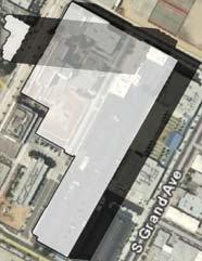
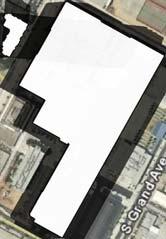
1 IV. ENVIRONMENTAL IMPACT ANALYSIS B. AESTHETICS INTRODUCTION This section evaluates the potential impacts of the Proposed Project on aesthetics, views and vistas, light and glare, and shade and shadows in the project area. Aesthetics refers to visual resources and the quality of what can be seen or overall visual perception of the environment, and may include such characteristics as building height and mass, development density, design character, and landscaping. Views refers to visual access and obstruction of prominent visual features, including both specific visual landmarks and panoramic vistas. Lighting issues address the effects of nighttime illumination and daytime glare on adjacent land uses. Shading issues are concerned with the shading effects of shadows cast by existing or proposed structures upon adjacent land uses. ENVIRONMENTAL SETTING Existing Visual Character Project Site The existing visual character of the project site consists of a 9.5-acre vacant property located in the densely urbanized Southeast Los Angeles community of the City of Los Angeles (City). The project site is bisected by South Flower Street, forming Site A and Site B. The project site is characterized by prior demolition activities, which included grading of the entire site. Currently, there is chain-link fencing with tarped portions along the majority of the project site s perimeter. Surrounding Area The existing visual setting of the project area is characterized by a dense mix of urban uses and the major transportation corridor of the Harbor Freeway (I-110) to the west of the project site. The area immediately surrounding the project site is somewhat visually incoherent as it encompasses buildings of various heights, uses, and build dates including those that are newly constructed in a contemporary design as well as buildings that are decades older and represent the architectural styles of former times. A fourstory residential building and the Felices Dias Adult Day Care facility are located north of Site B. The Los Angeles Trade Technical College (LATTC), which is comprised of various buildings with portions of the campus currently undergoing construction activities, characterize the properties to the north across West 23 rd Street. The contemporary two-story Orthopaedic Hospital Magnet High School (Magnet High School) grounds and a surface parking lot characterize the properties to the east. The irregularly-shaped Site A borders West Adams Boulevard at its southernmost extent, which is characterized by a six-story commercial building and a multi-level parking structure with above- and below-ground levels across from the project site. The two-story Los Angeles Orthopaedic Medical Center and the five-story Orthopaedic Medical Center (Lowman Outpatient Center) characterize the southwest portion of the block along the northern frontage of West Adams Boulevard between the project site and the I-110 Freeway. Site B is Page IV.B-1
2 bordered by the I-110 Freeway, which is below grade in this vicinity, and characterizes the visual environment in that area. Photos of surrounding uses are shown in Section III, Environmental Setting. Scenic Resources There are no unique, recognized, or valued views of natural visual resources (i.e., topographic features, trees, rock outcroppings) available from or through the project site. There are no views of cultural resources available from the project site as it is not within a 0.5-mile radius of any properties listed on the most recent list of California Points of Historic Interest, California Historical Landmarks, National Register of Historic Places, of City of Los Angeles Historic-Cultural Monuments. 1 Additionally, there are no State-designated scenic highways are located adjacent to or within the view of the project site. 2 However, the Community Plan Land Use Map designates northbound I-110 Freeway north of Martin Luther King Jr. Boulevard as a Scenic Freeway due to the available views of the Downtown Los Angeles skyline. There are very few areas designated for open space in the Southeast Los Angeles CPA or its environs that would allow for visual access to a large geographic area. However, views from the project area towards the Downtown Los Angeles skyline are visible in the distance to the north of the project site. These views of the Downtown Los Angeles skyline are largely limited to the public rights-of-way in the project area and are partially obstructed by intervening development. These views can be further obscured by smog, depending on atmospheric conditions. Existing Viewsheds Viewsheds refer to the visual qualities of a geographical area that are defined by the horizon, topography, and other natural features that give an area its visual boundary and context, or by development that has become a prominent visual component of the area. Views from the Project Site Views from the project site of the surrounding area are characterized by urban development. The visual setting of the project area is distinguished by structures with varying build dates, architectural styles, heights, setbacks, uses, and signage. Views immediately available from the project site looking 1 2 State of California, Office of Historic Preservation, website: September 18, 2007; National Park Service, National Register of Historic Places website: City of Los Angeles, Department of City Planning Historic/Cultural Monument Report, website: April 3, California Department of Transportation, Officially Designated State Scenic Highways, California Scenic Highway Program, website: April 3, Page IV.B-2
3 northward toward Downtown Los Angeles include the four-story residential building, the adult day care center and the LATTC, which is comprised of various buildings with portions of the campus currently undergoing construction activities. Due to the relatively flat topography and surrounding area, more distant views to the Downtown Los Angeles cityscape are available from the roadways surrounding the project site. However, as discussed above, these views are obscured by intervening development. Views to the east of the project site consist of the Magnet High School and low- to mid-rise commercial buildings. Views to the south are largely obstructed by the existing five-story commercial building and the two-story parking structure located south of the project site across West Adams Boulevard. From the project site looking southwest, the University of Southern California (USC) campus is not clearly visible in the distance across I-110 Freeway. The Galen Center, which is largely obstructed by intervening development, is the only visible building on the USC campus from the project site. The view to the west is dominated by I-110 Freeway with commercial uses and Mt. Saint Mary s College visible across the freeway. Views of and Toward the Project Site Views of and toward the project site consist of vacant parcels surrounded by existing urban uses described in detail above under Surrounding Area. These views are largely obstructed by the temporary placement of tarped chain-link fencing along much of the site s perimeter for security purposes during construction. Light The project site is located in the urbanized Southeast Los Angeles community, which generally experiences the high levels of ambient nighttime lighting that is common to densely populated areas. In the project area, high levels of ambient nighttime light is generated by street lighting, architectural and security lighting, and indoor building illumination (light emanating from the interior of structures which passes through windows). The project area is also subject to a high degree of ambient lighting from I-110 Freeway. The project site is vacant and, therefore, does not contain any structures that would emit light. However, there are moderate levels of spillover lighting is generated by vehicle headlights, street lights, and urban uses along the surrounding roadways. Glare Glare is largely a daytime phenomenon, occurring when sunlight is reflected off the surfaces of buildings, objects (e.g., vehicle windshields), or by vehicle headlights on adjacent roadways. Excessive glare not only restricts visibility but also increases the ambient heat reflectivity in a given area. As the project site is currently vacant, there are no sources of glare on-site. Shade and Shadow The issue of shade and shadow pertains to the blockage of direct sunlight by on-site buildings, which can affect adjacent properties. Shading is an important environmental issue because the users or occupants of Page IV.B-3
4 certain land uses, such as residential, recreational, churches, schools, outdoor restaurants, and pedestrian areas, have expectations for direct sunlight and warmth from the sun. These land uses are termed shadow-sensitive. Shadow lengths are dependent on the height and size of the building from which it is cast and the angle of the sun. The angle of the sun varies due to the rotation of the earth (i.e. time of day) and elliptical orbit (i.e. change in seasons). The longest shadows are cast during the winter months and the shortest shadows are cast during the summer months. Summer and Winter Solstice Solstice is defined as either of the two points on the ecliptic that lie midway between the equinoxes (separated from them by an angular distance of 90 ). At the solstices, the sun s apparent position on the celestial sphere reaches its greatest distance above or below the celestial equator, about 23 ½ of the arc. At the time of summer solstice, about June 22, the sun is directly overhead at noon at the Tropic of Cancer. In the Northern Hemisphere, the longest day and shortest night of the year occur on this date, marking the beginning of summer. At winter solstice, about December 22, the sun is overhead at noon at the Tropic of Capricorn; this marks the beginning of winter in the Northern Hemisphere. Measuring shadow lengths for the winter and summer solstices represents the extreme shadow patterns that occur throughout the year. Shadows cast on the summer solstice are the shortest shadows during the year, becoming progressively longer until winter solstice when the shadows are the longest they are all year. Shadows are shown for summer and winter solstice, cast from 9:00 a.m. to 5:00 p.m. (summer) and to 3:00 p.m. (winter). Existing Shadow Patterns The project site is currently vacant, and therefore does not generate any shadows. The existing shadowsensitive uses in the project area include: the recreational basketball courts at the Magnet High School adjacent to Site A and the LATTC swimming pool located north of the project site. While the four-story residential building is located north of Site B, it is not considered a sensitive use as it does not contain any routinely usable outdoor areas, such as a pool, patios, or balconies. ENVIRONMENTAL IMPACTS Thresholds of Significance Appendix G of the State CEQA Guideline In accordance with guidance provided in Appendix G of the State CEQA Guidelines, the Proposed Project could have a potentially significant impact if it were to result in one or more of the following: a. Have a substantial adverse effect on a scenic vista. Page IV.B-4
5 b. Substantially damage scenic resources, including, but not limited to, trees, rock outcroppings, and historic buildings within a State scenic highway. c. Substantially degrade the existing visual character or quality of the site and its surroundings. d. Create a new source of substantial light or glare which would adversely affect day or nighttime views in the area. City of Los Angeles CEQA Thresholds Guide Based upon criteria established in the City of Los Angeles CEQA Thresholds Guide, whether the Proposed Project would have a significant aesthetic impact is determined on a case-by-case basis considering the following factors: The amount or relative proportion of existing features or elements that substantially contribute to the valued visual character of image of a neighborhood community, or localized area, which would be removed, altered, or demolished; The amount of natural open space to be graded or developed; The degree to which proposed structures in natural open space areas would be effectively integrated into the aesthetics of the site, through appropriate design, etc; The degree of contrast between proposed features and existing features that represent the area s valued aesthetic image; The degree to which a proposed zone change would result in buildings that would detract from the existing style or image of the area due to density, height, bulk, setback, signage, or other physical elements; The degree to which the project would contribute to the area s aesthetic value; Applicable guidelines and regulations; The nature and quality of recognized or valued views (such as natural topography, settings, manmade or natural features of visual interest, and resources such as mountains or the ocean); Whether the project affects views from a designated scenic highway, corridor, or parkway; The extent of obstruction (e.g. total blockage, partial interruption, or minor diminishment); The extent to which the project affects recognized views from a length of a public roadway, bike path, or trail, as opposed to a single, fixed vantage point; If the shadow-sensitive uses would be shaded by the project-related structures for more than three hours between the hours of 9:00 a.m. and 3:00 p.m. Pacific Standard Time (between late October and early April), or for more than four hours between the hours of 9:00 a.m. and 5:00 p.m. Pacific Daylight Time (between early April and late October); Page IV.B-5
6 The change on ambient illumination levels as a result of project sources; and The extent to which project lighting would spill off the project site and effect adjacent lightsensitive areas. Project Impacts Visual Character The Proposed Project would redevelop the site with a total of 1,400 multi-family residential units (approximately 1,663,061 square feet of residential floor area) and ancillary common area and recreation amenities totaling approximately 65,480 square feet. The Proposed Project would also provide approximately 34,000 square feet of commercial retail uses at street level fronting the future Exposition Line light rail station along South Flower Street at West 23 rd Street. More specifically, the Proposed Project would consist of two structures: a six-story, 1,208,538-square-foot building located on Site A containing 919 multi-family residential units and ancillary common area and recreational amenities as well as commercial retail uses and a 44-story, 553, 993-square-foot building located on Site B containing 481 multi-family residential units. The Proposed Project would include retail uses on Site A fronting South Flower Street and on the corner of South Flower Street and West 23 rd Street. Pedestrian access to the retail uses would be at ground level and include an arcade characterized by a series of arches supported by columns. Figures II-11 through II- 13 in Section II, Project Description depict the proposed elevations for the project. Safe pedestrian access would be provided between Site A and Site B via a 2 nd floor pedestrian bridge over South Flower Street. The remainder of the ground floor of the Proposed Project would consist mainly of vehicle parking. Height The project site is located in Height District No. 2, which does not have a height limit but imposes a limit on a structure s size to six times the buildable area of the lot in a C2 zone. However, Community Plan Land Use Map Footnote 1 restricts Site A to Height District No. 1, which allows for a 1.5:1 floor area ratio (FAR). The applicant is requesting a General Plan Amendment to restore Height District 2 by eliminating the applicability of Footnote 1/Height District No. 1 to the Proposed Project site. The General Plan Amendment is required to exempt the Proposed Project site from the application of Community Plan Footnote 1/Height District No. 1, which restricts the FAR to 1.5:1. Height of structures within Height District 2 (or Height District 1) is unlimited. The immediate surrounding buildings vary from one to six stories in height including the four-story residential building located on the west side of South Flower Street, a five-story hotel located on West Adams Boulevard just south of the project site, the six-story Orthopaedic medical office building directly adjacent to the project site, and a six-story commercial building is located on the corner of West Adams Boulevard and Grand Avenue just south of the project site. Nearby high-rise structures include the 13- story LA Mart building located approximately 0.3 miles northeast of the project site and the 10-story Bob Page IV.B-6
7 Hope Patriotic Hall located 0.35 miles north of the project site. The Proposed Project would involve the development of one 44-story building (approximately 527 feet in height) and one six-story building (approximately 73 feet in height). Visual simulations of the Proposed Project in the context of the existing setting are provided in Figures IV.B-1 and IV.B-2. As shown in the illustrations, development on Site A would be compatible and complementary to the visual character of the project area. However, the 44-story building would represent the tallest building in the immediate project area and would present a substantial contrast between the surrounding uses and the proposed building. As the project would represent a substantial contrast between the surrounding uses and the project site, a significant impact with respect to height would occur. Massing The Proposed Project would introduce a six-story building and a 44-story building to a currently vacant site, representing a substantial change in the sense of massing on-site. The 44-story component of the Proposed Project would represent the tallest structure in the immediate area. As mentioned above, nearby high-rise structures include the 13-story LA Mart building located approximately 0.3 miles northeast of the project site and the 10-story Bob Hope Patriotic Hall located 0.35 miles north of the project site. Downtown Los Angeles, which is home to many high-rise buildings, is located approximately 1.25 miles north of the project site. The intensity and height of the proposed residential mixed-use development would represent a substantial change with respect to massing in comparison to current site conditions and would be inconsistent with the immediate surrounding uses (see Figures IV.B-1 and IV.B-2). As the project would represent a substantial contrast between the existing uses as well as the surrounding uses, a significant impact with respect to massing would occur. Page IV.B-7

8 View looking north along West Adams Boulevard (before). View looking north along West Adams Boulevard (after). Source: Christopher A. Joseph & Associates, Figure IV.B-1 View Looking West Along West Adams Boulevard

9 View looking north along I-110 with project. Source: Christopher A. Joseph & Associates, Figure IV.B-2 View Looking North Along I-110 Freeway
10 Scenic Resources As previously discussed, scenic resources are limited in the project area. Views of the Downtown Los Angeles skyline, USC, and Exposition Park are considered a scenic resource. South of the project site traveling north on I-110 Freeway, a larger field of view is available which includes views of the Downtown Los Angeles Skyline to the north and USC and Exposition Park to the west. With respect to views from northbound I-110 Freeway, implementation of the Proposed Project would not impact views of USC and Exposition Park as these resources are located west of I-110 Freeway and the Proposed Project would be located north of these resources to the east of I-110 Freeway, thereby not resulting in any obstruction of these views. With respect to views of the Downtown Los Angeles skyline, the Proposed Project would not result in complete obstruction, but rather a partial interruption, of the available Downtown views (see Figure IV.B-2). In addition, persons traveling on the northbound I-110 Freeway are generally traveling at a high rate of speed and the interruption of views caused by the Proposed Project would represent a very brief interruption. As shown in Figure IV.B-2, views of the downtown skyline are only slightly visible from the I-110 Freeway traveling north in the project vicinity. The Proposed Project would obstruct a small proportion of the available field of view, and cars traveling would then pass the proposed tower while approaching downtown, seeing the downtown skyline more closely after passing the proposed tower. The result of the Proposed Project would not consist of a solid wall of development that would block the entire field of view, but rather a small proportion of the view. Thus, development of the Proposed Project would not constitute a significant impact with respect to public views of scenic resources. Views of and Toward the Project Site Currently, the project site is visible to the immediate surrounding uses but is not visible from distant vantage points. With the Proposed Project, views of the project site would be more visible due to the increased height and massing. Though views of the Downtown Los Angeles skyline are visible from the project site, they are largely obstructed by intervening development and are generally afforded along the public rights-of-way when looking north from the project site. Thus implementation of the Proposed Project would not result in the loss of panoramic views of Downtown Los Angeles from the project area. The Proposed Project would replace the vacant project site with 1,400 residential units and approximately 34,000 square feet of commercial retail uses. The proposed development on Site B would substantially change the current appearance and increase the amount of development and visibility of the project site. Views of the project site would be available from more off-site locations than at present because of the increased height and mass of development on the site. The proposed development on the project site would contribute to the urbanized character of the surrounding area. A rendering of the Proposed Project, with the existing Orthopedic Hospital, is provided as Figure IV.B-3. Through landscaping that would include various trees and shrubs along the perimeter Page IV.B-10
11 and in the proposed courtyards of the developed project site, the change in the visual appearance of the project site would be beneficial as it would transform a vacant, dirt lot to an integrated part of the urban fabric. Impacts related to the change in the visual appearance of the project site would be less than significant, as viewed from the adjacent streets and areas surrounding the project site. Signage No signage program is currently proposed as part of the project. Within the C2 zone, the LAMC permits the use of advertising signs or structures and billboards. In order to ensure compliance with the LAMC, Mitigation Measure B-4 is included below. With implementation of Mitigation Measure B-4, impacts related to signage would be less than significant. Light The Proposed Project would include low-level security lighting and illuminated walkways, building entrances, parking areas, and driveways to provide adequate night visibility for residents and visitors to provide a measure of security. The Proposed Project would likely also produce light emitted from the interiors of the proposed residences and retail areas. As the Proposed Project would increase the density and height of buildings on the project site, this increase in lighting would be moderate. However, the increased lighting generated by the Proposed Project would not be considered substantial in comparison to the existing ambient light generated by the surrounding urban uses, the adjacent roadways, which are illuminated by street lights and vehicle headlights, and I-110 Freeway. As such, the Proposed Project would have a less than significant impact with respect to light. Page IV.B-11

12 Source: Christopher A. Joseph & Associates, Figure IV.B-3 Proposed Project Rendering
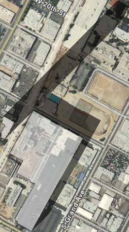
13 Glare Most of the existing daytime glare in the project area is generated from vehicles passing along South Flower Street, Grand Avenue, and West Adams Boulevard. The level of glare in the project area is moderate, as most buildings in the vicinity do not have reflective surfaces. Additionally, the I- 110 Freeway is at a lower grade than the Proposed Project and thus does not expose the project site to potential glare from vehicles on the I-110 Freeway. As the Proposed Project would increase the intensity of the structures on the project site, it is possible the Proposed Project would increase the amount of glareinducing reflective surfaces (i.e., windows) on the project site. The exterior portions of the proposed building would incorporate a variety of non-reflective material that would minimize the transmission of glare from building materials. In addition, the Proposed Project would incorporate exterior landscaping, as needed, that would minimize the potential glare generated by the project from windows and glass panels. Building materials would be expected to minimize potential glare effects along West Adams Boulevard, West 23 rd Street, and South Flower Street. However, the potential exists for glass or other shiny building materials to cause glare impacts at nearby residential uses and the Orthopaedic Magnet High School as the surrounding streets would continue to be the major contributor to project area daytime glare. Additionally, glare created by the Proposed Project would have the potential to reflect onto vehicles traveling on the surrounding streets and on I-110 Freeway. However, vehicles in the surrounding area would generally be traveling at a high rate of speed and would be subjected to glare for a brief moment, which would not lead to unsafe driving conditions. Nonetheless, implementation of the Mitigation Measure IV.B-3 below would help reduce impacts associated with glare to a less than significant level. Shade and Shadow A shadow analysis was prepared for the Proposed Project. Figure IV.B-1 shows the potential summer solstice shadows cast by the Proposed Project at 9:00 AM, 1:00 PM, and 5:00 PM. Figure IV.B-2 shows the potential winter solstice shadows cast by the Proposed Project at 9:00 AM, 12:00 PM, and 3:00 PM. It should be noted that the jogging track and tennis courts shown on the Figures IV.B-4 and IV.B-5 no longer exist. Construction is on-going at the LATTC campus and the jogging track and tennis courts have been removed subsequent to the date of the aerial photograph. Summer Solstice The shortest shadows are cast during the summer months. Summer shadows are cast toward the west in the morning and move toward the north around 12:00 PM. and then move to the east in the evening. Because of the relationship of the earth and sun during the summer, Northern Hemisphere summer shadows around noon will be at their shortest length of the year. As shown in Figure IV.B-4, the Proposed Project would shade portions of the LATTC and Magnet High School at 5:00 PM. However, these uses would not be shaded at 9:00 AM or 1:00 PM. Therefore, summer shadows associated with the Proposed Project would not be cast off-site onto shadow-sensitive uses for more than four hours between Page IV.B-13
14 the hours of 9:00 AM and 5:00 PM Pacific Daylight Time (between mid-march and early November) and summer shadow impacts would be less than significant. Page IV.B-14


15 1:00 pm 9:00 am 5:00 pm PROJECT SITE Source: Google Earth Pro; Nelson-Boivin Architects, Scale (Feet) Figure IV.B-4 Summer Solstice Shadows June 21st
16 Winter Solstice As previously discussed, the longest shadows are cast during the winter months and the shortest shadows are cast during the summer months. Winter shadows are cast in a northwestern direction in the morning and move towards the east until cast in a northeastern direction in the evening. As shown in Figure IV.B-5, at 9:00 AM, the shadows would be cast in a northwest direction. The Proposed Project would not shade the Magnet High School, but would shade a small portion of the southern border of the LATTC. However, the LATTC swimming pool would not be shaded at this time. At 12:00 PM, shadows from the Proposed Project would be cast to the north. The proposed 44-story tower would create a narrow shadow that would not shade any shadow-sensitive uses, while the shadow from the proposed six-story building would be cast upon a small portion of the LATTC campus. The LATTC pool would not be shaded at 12:00 PM. At 3:00 PM, the shadow from the 44-story tower would be cast to the northeast and would partially shade portions of the LATTC campus. The proposed sixstory building would cast a shadow on the LATTC swimming pool and portions of the Magnet High School, including the basketball courts. As stated previously, a significant impact would occur if the shadow-sensitive uses would be shaded by the project-related structures for more than three hours between the hours of 9:00 AM and 3:00 PM Pacific Standard Time (between early November and mid- March). As shown in Figure IV.B-5, the Proposed Project would not shade any sensitive use for more than three hours. Therefore, with respect to the Proposed Project, winter solstice impacts would be less than significant. Page IV.B-16


17 9:00 am 12:00 pm 3:00 pm PROJECT SITE Source: Google Earth Pro; Nelson-Boivin Architects, Scale (Feet) Figure IV.B-5 Winter Solstice Shadows December 21st
18 CUMULATIVE IMPACTS Development of the Proposed Project in conjunction with the related projects, outlined in Section III Environmental Setting, would result in a mix of new development and redevelopment, or infilling, of residential, educational, industrial, and commercial land uses in the Southeast Los Angeles community. As shown on Figure III-6, Related Projects Location Map, the majority of the related projects are located within Downtown Los Angeles. There are no related projects adjacent to the project sites that would contribute a cumulatively significant aesthetic impact as viewed from south of the project site looking toward the Downtown skyline. Essentially, the Proposed Project combined with the related projects would not result in a wall of development that would block the available views of Downtown Los Angeles. Intermittent views of the Downtown skyline would remain continue to be available with development of the Proposed Project and related projects. Therefore, the Proposed Project in conjunction with the related projects, would not result in significant cumulative impacts with regard to the aesthetic and visual character of the area. Related project numbers 2, 6, and 13 are located either adjacent or directly across the street from the Proposed Project. These related projects consist of apartments, the Magnet High School (which is complete), and the LATTC, respectively. These projects, in combination with the Proposed Project, have the potential to increase the amount of ambient lighting and glare levels in the immediate project vicinity. The levels of ambient light in the project area are currently moderate and the development of these projects would slightly increase the overall ambient light levels. Nonetheless, as with the Proposed Project, the related projects would be required to comply with the lighting standards set forth in the LAMC. With respect to glare, the related projects would be subject to the City s reflective materials design standards, which limits the amount of reflective surface areas and materials that can be used for any given project. Therefore, the Proposed Project, in conjunction with the related projects would not result in significant cumulative impacts with regard to lighting and glare in the project area. Development of the Proposed Project would result in a less than significant shade and shadow impact on nearby residences during the winter. Due to the locations of the related projects (north, east, and southeast), these related projects would not combine with the Proposed Project to create significant shade and shadow impacts to surrounding sensitive receptors. Thus, the Proposed Project in combination with the related projects, would not contribute to a cumulatively considerable impact with respect to shade and shadow. MITIGATION MEASURES Mitigation Measures B-1. B-2. Project lighting shall be directed onto the site, and all lighting shall be shielded from adjacent roadways and off-site properties. Atmospheric light pollution shall be minimized by utilizing lighting fixtures that cut off light directed to the sky. Page IV.B-18
19 B-3. B-4. All glass to be incorporated into the exterior of the building shall be either of low-reflectivity, or accompanied by a non-glare coating. On-site signs shall be limited to the maximum allowable under the LAMC. Multiple temporary signs in the store windows and along the building walls are not permitted. LEVEL OF SIGNIFICANCE AFTER MITIGATION Impacts related to light and glare would be less than significant. Impacts of the Proposed Project related to views of and through the project site and shade and shadow would be less than significant. The Proposed Project would result in a significant impact with respect to visual character due to the significant contrast in height and massing between proposed features and existing features in the area. Page IV.B-19
IV. ENVIRONMENTAL IMPACT ANALYSIS B. AESTHETICS 1. VIEWS
 IV. ENVIRONMENTAL IMPACT ANALYSIS B. AESTHETICS 1. VIEWS ENVIRONMENTAL SETTING Existing Visual Character Project Site The project site is located at 10250 Wilshire Boulevard in the Westwood community of
IV. ENVIRONMENTAL IMPACT ANALYSIS B. AESTHETICS 1. SHADE/SHADOW
 IV. ENVIRONMENTAL IMPACT ANALYSIS B. AESTHETICS 1. SHADE/SHADOW ENVIRONMENTAL SETTING The issue of shade and shadow pertains to the blockage of direct sunlight by onsite buildings, which affect adjacent
IV. ENVIRONMENTAL IMPACT ANALYSIS B. AESTHETICS 1. VIEWS
 IV. ENVIRONMENTAL IMPACT ANALYSIS B. AESTHETICS 1. VIEWS INTRODUCTION This section evaluates the potential impacts of the Proposed Project on aesthetics, views and vistas, light and glare, and shade and
IV.B. VISUAL RESOURCES
 IV.B. VISUAL RESOURCES ENVIRONMENTAL SETTING Existing Visual Character Project Site The project site is located at 17331-17333 Tramonto Drive in the Pacific Palisades community of the City of Los Angeles
IV. ENVIRONMENTAL IMPACT ANALYSIS B. AESTHETICS 1. AESTHETICS/VIEWS
 IV. ENVIRONMENTAL IMPACT ANALYSIS B. AESTHETICS 1. AESTHETICS/VIEWS ENVIRONMENTAL SETTING Aesthetic impact assessment generally deals with the issue of contrast, or the degree to which elements of the
VISUAL RESOURCES 1. INTRODUCTION 2. EXISTING CONDITIONS. a. Visual Character
 IV.A VISUAL RESOURCES 1. INTRODUCTION This section addresses the potential changes in visual character that would result from implementation of the proposed Wilshire and La Brea Project. Also evaluated
The impacts examined herein take into account two attributes of aesthetic values:
 IV. ENVIRONMENTAL IMPACT ANALYSIS This section addresses the potential impacts to views and aesthetics as a result of the proposed Project at the Project Site and the development scenarios analyzed for
Nob Hill Pipeline Improvements Project EIR
 Section 3.1 Aesthetics This section addresses the visual aspects that may affect the views experienced by the public, including the potential to impact the existing character of each area that comprises
ENVIRONMENTAL IMPACT ANALYSIS
 IV. ENVIRONMENTAL IMPACT ANALYSIS A. AESTHETICS This section addresses the potential impacts to aesthetics and views that could result from the proposed project, including development of the Add Area,
a) Would the project have a substantial adverse effect on a scenic vista?
 Would the project have a substantial adverse effect on a scenic vista?") 1. AESTHETICS In 2013, the State of California enacted Senate Bill 743 (SB 743), which made several changes to the California Environmental Quality Action (CEQA) for projects located in areas served by
1. AESTHETICS In 2013, the State of California enacted Senate Bill 743 (SB 743), which made several changes to the California Environmental Quality Action (CEQA) for projects located in areas served by
5.1 AESTHETICS AND VISUAL RESOURCES Physical Setting
 5.1 AESTHETICS AND VISUAL RESOURCES 5.1.1 Physical Setting Aesthetic values are an important aspect in establishing the identity, sense of place, and quality of life in a community. Natural features in
IV. Environmental Impact Analysis A. Aesthetics, Views, Light/Glare, and Shading
 IV. Environmental Impact Analysis A. Aesthetics, Views, Light/Glare, and Shading 1. Introduction This section addresses the potential impacts that could result from the project with regard to aesthetics,
IV. ENVIRONMENTAL IMPACT ANALYSIS
 IV. ENVIRONMENTAL IMPACT ANALYSIS IV. ENVIRONMENTAL IMPACT ANALYSIS A. AESTHETICS AND VIEWS 1. INTRODUCTION This section analyzes the potential impacts that could result from the proposed project with
ENVIRONMENTAL IMPACT ANALYSIS A. AESTHETICS 1. INTRODUCTION
 IV. ENVIRONMENTAL IMPACT ANALYSIS 1. INTRODUCTION Aesthetics, views, nighttime illumination, and daytime glare are related elements in the visual environment. Aesthetics generally refers to the identification
Harvard-Westlake Parking Improvement Plan, Lighting Evaluation, Lighting Design Alliance, September 25, 2013 (Appendix I)
") 3.1 AESTHETICS The purpose of this section is to characterize the visual (aesthetic) environment that currently exists in the Project area and to identify potential impacts to: visual character, views
3.1 AESTHETICS The purpose of this section is to characterize the visual (aesthetic) environment that currently exists in the Project area and to identify potential impacts to: visual character, views
IV.B. VISUAL RESOURCES
 IV.B. VISUAL RESOURCES INTRODUCTION This section identifies and describes the visual characteristics of the project site and surrounding area and evaluates the potential change in the existing visual character
1. INTRODUCTION. a. Light. b. Glare
 IV.A.2 LIGHT & GLARE 1. INTRODUCTION This section describes the existing sources of nighttime illumination and glare on the Project site and in the surrounding area and evaluates potential changes resulting
4.0 AFFECTED ENVIRONMENT AND ENVIRONMENTAL CONSEQUENCES
 4.0 AFFECTED ENVIRONMENT AND ENVIRONMENTAL CONSEQUENCES The following sections discuss the impacts associated with environmental resources for the tunneling method Alternatives A and B. The construction
4.1 AESTHETICS WATSON INDUSTRIAL PARK ENVIRONMENTAL IMPACT REPORT EXISTING CONDITIONS
 This Subsection describes the aesthetic qualities and visual resources present on the Project site and in the site s vicinity and evaluates the potential effects that the Project may have on these resources.
3.1 Aesthetics, Light, and Glare
 3.1 3.1.1 Introduction This section describes the existing aesthetics, light, and glare setting and potential effects from project implementation on visual resources and the site and its surroundings.
ENVIRONMENTAL IMPACT ANALYSIS A. AESTHETICS
 IV.A Aesthetics IV. ENVIRONMENTAL IMPACT ANALYSIS A. AESTHETICS This section addresses the potential impacts to aesthetics and views that could result from the proposed project. The analysis of aesthetics
CHAPTER 10 AESTHETICS
 CHAPTER 10 AESTHETICS CHAPTER 10 AESTHETICS This section identifies and evaluates key visual resources in the project area to determine the degree of visual impact that would be attributable to the project.
Environmental Setting, Impacts, and Mitigation Measures
 CHAPTER 3 Environmental Setting, Impacts, and Mitigation Measures Format of the Environmental Analysis The assessment of each environmental resource discussed in this chapter includes the following: Environmental
5. Environmental Analysis
 5.1 This section of the Draft Environmental Impact Report (DEIR) describes the existing landform and aesthetic character of the project area and discusses the potential impacts to the visual character
4.1 AESTHETICS INTRODUCTION METHODOLOGY
 LSA ASSOCIATES, INC. R ECIRCULATED DRAFT ENVIRONMENTAL IMPACT REPORT 4.1 AESTHETICS 4.1.1 INTRODUCTION This section defines the existing visual setting on and in the vicinity of the project site and analyzes
ADDENDUM TO THE LOS ANGELES TRADE-TECHNICAL COLLEGE THIRTY YEAR MASTER PLAN EIR (SCH NO )
") ADDENDUM TO THE LOS ANGELES TRADE-TECHNICAL COLLEGE THIRTY YEAR MASTER PLAN EIR (SCH NO. 2004121007) Prepared for: LOS ANGELES COMMUNITY COLLEGE DISTRICT Prepared by: 25031 W. Avenue Stanford Suite 50
ADDENDUM TO THE LOS ANGELES TRADE-TECHNICAL COLLEGE THIRTY YEAR MASTER PLAN EIR (SCH NO. 2004121007) Prepared for: LOS ANGELES COMMUNITY COLLEGE DISTRICT Prepared by: 25031 W. Avenue Stanford Suite 50
4.1 AESTHETICS AND VISUAL QUALITY
 SCOPE AND METHODOLOGY 4.1 AESTHETICS AND VISUAL QUALITY This section evaluates the potential impacts to aesthetics and visual quality. Aesthetics refers to visual resources and the quality of what can
4.1 AESTHETICS EXISTING ENVIRONMENTAL SETTING ALAMITOS BAY MARINA REHABILITATION PROJECT CITY OF LONG BEACH
 4.1 AESTHETICS This section provides a discussion of the existing visual and aesthetic resources on site and in the surrounding area as well as an analysis of potential impacts from implementation of the
IV.A AESTHETICS INTRODUCTION
 IV.A AESTHETICS INTRODUCTION This section addresses the potential impacts to visual character, views and vistas, scenic resources, light and glare, and shadows that could result from the implementation
Appendix I Lighting Evaluation
 Appendix I Lighting Evaluation Harvard Westlake Parking Improvement Plan Lighting Evaluation By: Lighting Design Alliance 27 September 2013 Harvard Westlake Parking Improvement Plan Lighting and Glare
3.1 AESTHETICS AND VISUAL RESOURCES
 3.1 AESTHETICS AND VISUAL RESOURCES This section examines the potential for the proposed Project to create aesthetic and visual impacts as defined by the California Environmental Quality Act (CEQA) as
3.1 AESTHETICS Background and Methodology
 3.1 AESTHETICS 3.1.1 Background and Methodology 3.1.1.1 Regulatory Context The California Environmental Quality Act (CEQA) requires that project sponsors evaluate the project s potential to cause aesthetic
WESTSIDE SUBWAY EXTENSION PROJECT. Addendum to the Visual and Aesthetic Impacts Technical Report
 PROJECT to the Visual and Aesthetic Impacts Technical Report August 2011 Visual and Aesthetic Impacts Technical Report SUMMARY On October 28, 2010, the Metro Board selected the Westwood/VA Hospital Extension
3.0 URBAN DESIGN. December 6, OVERVIEW
 Urban Design 3.0 URBAN DESIGN December 6, 2007 3.1 OVERVIEW The highly urban character of Easton Place is defined by the overall design of the community. The following sections provide an overview of the
5.1 AESTHETICS Environmental Setting Scenic Views FONTANA FORWARD GENERAL PLAN UPDATE DRAFT ENVIRONMENTAL IMPACT REPORT
 5.1 AESTHETICS This section describes the City s scenic resources, and landscape and neighborhood characteristics, and addresses the potential impacts on aesthetic and visual resources associated with
Urban Design Brief to 1557 Gordon Street & 34 Lowes Road West
 Urban Design Brief 1533 to 1557 Gordon Street & 34 Lowes Road West Reid s Heritage Homes Ltd. & 883928 Ontario Ltd. and RHH Property Management Ltd. City of Guelph Zoning By-law Amendment November 2017
4.8 LAND USE AND PLANNING
 4.8 LAND USE AND PLANNING 4.8.1 INTRODUCTION This section describes existing and planned land uses at the Hayward campus and analyzes the impact of implementation of the proposed Master Plan on land uses
IV. ENVIRONMENTAL IMPACT ANALYSIS
 IV. ENVIRONMENTAL IMPACT ANALYSIS A. AESTHETICS/VIEWS EXISTING CONDITIONS REGIONAL SETTING The project area (between Devonshire Street and the SR-118 freeway) is generally characterized by single-family
178 Carruthers Properties Inc.
 178 Carruthers Properties Inc. Planning Rationale for 178 Carruthers Avenue Site Plan Control Application June 2014 Table of Contents 1.0 Introduction 2.0 Overview of Subject Property 3.0 Current Zoning
SECTION 5.1 Aesthetics, Light, and Glare
 SECTION 5.1 Aesthetics, Light, and Glare 5.1 AESTHETICS, LIGHT, AND GLARE Visual resources information for this section was compiled from photographs and site surveys conducted by RBF Consulting. The purpose
Visual and Aesthetics
 Such a connection could accommodate timed transfers and improve connections between local transit service and Presidio Shuttle service. Level of Service The results of the analysis are provided on a route-by-route
County of Loudoun. Department of Planning MEMORANDUM. SUBJECT: ZMOD , Dulles North Business Park Comprehensive Sign Plan, 2 nd Referral
 County of Loudoun Department of Planning MEMORANDUM DATE: May 30, 2014 TO: FROM: Ginny Rowen, Project Manager Land Use Review Pat Giglio, Planner III Community Planning SUBJECT: ZMOD 2013-0001, Dulles
PLANNING COMMISSION AGENDA REPORT NOVEMBER 15, 2012
 PLANNING COMMISSION AGENDA REPORT NOVEMBER 15, 2012 TO: FROM: Members of the Planning Commission Michael Klein, Associate Planner FILE NO.: 120000890 PROPOSAL: APPLICANT: Request for an Administrative
4 Residential and Urban Living Zones
 4 Residential and Urban Living Zones Refer to Chapters 11 to 20 for additional rules that may apply to these zones. 4.1 OBJECTIVES AND POLICIES Objective Res1 Policy 1 Policy 2 Policy 3 Policy 4 Policy
4.1 AESTHETICS. A. Regulatory Framework
 4.1 This section includes a description of the existing visual setting of the project site and an analysis of the effects the proposed project would have on aesthetics in the project vicinity. Aesthetics
APPENDIX D: Visual and Aesthetic Conditions for NCCU Station Refinement. Durham-Orange Light Rail Transit Project
 APPENDIX D: Visual and Aesthetic Conditions for NCCU Station Refinement Durham-Orange Light Rail Transit Project October 2016 1. Introduction The Combined FEIS/ROD summarizes the effects of the D-O LRT
36.1. PURPOSE APPLICABILITY DESIGN REVIEW GUIDELINES
 CHAPTER 36: DESIGN STANDARDS 36.1. PURPOSE The purpose of this chapter is to ensure that projects are designed and constructed consistent with the Community Design Subelement of the Land Use Element and
California Department of Transportation (Caltrans) Scenic Highway Program
 Scenic Highway Program") 3.1. AESTHETICS This section is an assessment of the potential for the Proposed Project to create construction and/or operational aesthetic impacts. This assessment includes a summary of the regulatory
3.1. AESTHETICS This section is an assessment of the potential for the Proposed Project to create construction and/or operational aesthetic impacts. This assessment includes a summary of the regulatory
3.5 VISUAL AND AESTHETIC QUALITIES
 3.5 VISUAL AND AESTHETIC QUALITIES 3.5.1 Introduction to Analysis 3.5.1.1 Summary of Results The Preferred Alternative would represent a minimal change to the visual character of the existing rail corridor.
URBAN DESIGN BRIEF. 2136&2148 Trafalgar Road. Town of Oakville
 URBAN DESIGN BRIEF 2136&2148 Trafalgar Road Town of Oakville Prepared By: METROPOLITAN CONSULTING INC For 2500674 Ontario Inc November 2016 TABLE OF CONTENTS Page No. 1.0 Introduction/Description of Subject
3A. Aesthetics. 3A.1 Environmental Setting. Regional Character. Project Site
 The purpose of this section is to identify and evaluate key visual resources in the project area from public viewpoints, and to determine the degree of visual impacts that could occur if the proposed project
920 BAYSWATER AVENUE PROJECT
 920 BAYSWATER AVENUE PROJECT VISUAL ASSESSMENT Prepared for the City of Burlingame Prepared by Circlepoint 46 S First Street, San Jose, CA 95113 June 2018 This page intentionally left blank. 920 Bayswater
RZC Public View Corridors and Gateways
 RZC 21.42 Public View Corridors and Gateways 21.42.010 Purpose 21.42.020 Scope and Authority 21.42.030 Administration 21.42.040 Gateways Design 21.42.050 Unidentified Public Views 21.42.060 Identification
5.4.6 Cumulative Operational Impacts
 5.4.5.2 Visual Character Impacts The proposed project is located in greater downtown Los Angeles, which is a dynamic environment where new projects are constructed on an ongoing basis. Additional development
Silverlakes Equestrian Sports Park Draft Environmental Impact Report
 Silverlakes Equestrian Sports Park Draft Environmental Impact Report Aesthetics 4.1 - Aesthetics 4.1.1 - Introduction This section describes the existing aesthetic setting and potential effects from project
(DC1) Direct Development Control Provision DC1 Area 4
 Direct Development Control Provision DC1 Area 4") . General Purpose (DC) Direct Development Control Provision DC Area 4 The purpose of this Provision is to provide for an area of commercial office employment and residential development in support of the
. General Purpose (DC) Direct Development Control Provision DC Area 4 The purpose of this Provision is to provide for an area of commercial office employment and residential development in support of the
GENERAL PLAN CONSISTENCY ANALYSIS
 GENERAL PLAN CONSISTENCY ANALYSIS Prepared by Planning Staff 10/28/2013 APPLICABLE GOALS, POLICIES AND PROGRAMS FROM the LAND USE CHAPTER Goal LU-1 Policy LU-1.1 Policy LU-1.2 Goal LU-2 Protect the character
AMEND DMENT H HOSPITAL
 AMEND DMENT TO LAND USE PLAN ELEMENT VILLAGE OF RIDGEWOOD MASTER PLAN H HOSPITAL ZONE DISTRICT Village of Ridgewood Planning Board February 28, 2014with technical revisions from June 9, 2014 Planning Board
DRAFT ENVIRONMENTAL IMPACT REPORT DEEP VALLEY DRIVE AND INDIAN PEAK ROAD MIXED-USE RESIDENTIAL PROJECT
 LSA ASSOCIATES, INC. JUNE 2012 SECTION 4.1 AESTHETICS DRAFT ENVIRONMENTAL IMPACT REPORT 4.1 AESTHETICS Introduction This section provides a discussion of the existing visual and aesthetic resources on
Visual Impact Assessment 830 Pratt Avenue St Helena, CA
 Visual Impact Assessment 830 Pratt Avenue St Helena, CA 1. Introduction The following aesthetic visual impact assessment has been prepared pursuant to the California Environmental Quality Act (CEQA). The
5.8 Visual Resources and Aesthetic Qualities
 I-70 East Supplemental Draft EIS 5.8 Visual Resources and Aesthetic Qualities 5.8 Visual Resources and Aesthetic Qualities This section discusses the visual resources and aesthetic qualities of the study
6.8 SCENIC HIGHWAYS Introduction
 6.8 SCENIC HIGHWAYS 6.8.1 Introduction The Scenic Highways Element is an optional General Plan element authorized by Section 65303 of the Government Code. The Scenic Highways Element is intended to establish
Chapter 5: Mixed Use Neighborhood Character District
 5: Mixed Use Neighborhood Character District 5.1 Introduction The Mixed Use Neighborhood character district acts as a transition or bridge between the State Route 89A District s commercial area to the
4.1 Aesthetics Setting. a. Visual Character
 Environmental Impact Analysis Aesthetics 4.1 Aesthetics This section analyzes the proposed Specific Plan s impacts related to aesthetics, including the existing visual character of and scenic views in
APPENDIX B. Aesthetics Technical Report
 APPENDIX B Aesthetics Technical Report DRAFT Prepared for: San Diego State University Facilities Planning, Design, and Construction 5500 Campanile Drive San Diego, California 92182-1624 Contact: Laura
CONTENTS 8.0 LAND USE 8.1 GENERAL LAND USE 8.2 RESIDENTIAL 8.3 MIXED USE 8.4 COMMERCIAL 8.5 EMPLOYMENT LANDS
 8-2 Land Use 8.0 LAND USE CONTENTS 8.1 GENERAL LAND USE 8.1.1 Uses provided for in all Land Use Designations 8.1.2 Uses prohibited in Hazardous Lands, Hazardous Sites and Special Policy Areas 8.1.3 Uses
URBAN DESIGN BRIEF 305, 309, & 315 SOUTHDALE ROAD WEST LONDON ONTARIO
 URBAN DESIGN BRIEF 305, 309, & 315 SOUTHDALE ROAD WEST LONDON ONTARIO CARVEST PROPERTIES LTD. December 2013 Section 1 - Land Use Planning Context 1.1 Subject Lands The subject lands are located immediately
Urban Design Brief Woodland Cemetery Funeral Home 493 Springbank Drive
 Urban Design Brief Woodland Cemetery Funeral Home The Incorporated Synod of the Diocese of Huron April 15, 2016 Urban Design Brief April 15, 2016 TABLE OF CONTENTS Page No. INTRODUCTION... 1 SECTION 1
ELMVALE ACRES SHOPPING CENTRE MASTER PLAN
 ELMVALE ACRES SHOPPING CENTRE MASTER PLAN Contents 1.0 INTRODUCTION... 2 2.0 LOCATION... 2 3.0 EXISTING CONTEXT... 2 4.0 VISION & GUIDING PRINCIPLES... 2 5.0 LAND USE AND BUILT FORM... 4 5.1 St. Laurent
New-Cast Mixed-use Development Proposal King Street West, Newcastle, Ontario
 URBAN DESIGN BRIEF New-Cast Mixed-use Development Proposal King Street West, Newcastle, Ontario TABLE OF CONTENTS: 1.0 Executive Summary 2.0 Creating Vibrant and Sustainable Urban Places: Excerpts from
Commercial Development Permit Area
 City of Kamloops KAMPLAN Commercial Development Permit Area PURPOSE The purpose of this Development Permit Area (DPA) is to establish objectives and provide guidelines for the form and character of commercial
CHAPTER FIVE COMMUNITY DESIGN
 CHAPTER FIVE COMMUNITY DESIGN CHAPTER FIVE - COMMUNITY DESIGN Assumptions Frazier Park and Lebec have historically developed according to different patterns of spatial form. While both communities are
Regency Developments. Urban Design Brief. Holyrood DC2 Rezoning
 Regency Developments Urban Design Brief Holyrood DC2 Rezoning Stantec Consulting Ltd. 7-31-2017 1. Overview Regency Developments intends to rezone the lands located at 8510 and 8511 93 Avenue, within the
Chapter 4 Urban Design Element
 Chapter 4 Urban Design Element "The general tenor of the responses indicates a strong preference to not allow low-intensity development into natural areas, resource lands or highly visible open space.
Table of Contents. Elm Avenue Improvement Plan City of Waco, Texas. Introduction 1. Existing Context 1 Figure 1 2.
 Table of Contents Introduction 1 Existing Context 1 Figure 1 2 Plan Guidelines 3 Future Urban Form 4 The West-End 4 Main Street 6 The East-End 7 Figure 2 9 Public Improvement Recommendations 7 General
PROPOSED WATERFRONT DISTRICT DESIGN STANDARDS
 PROPOSED WATERFRONT DISTRICT DESIGN STANDARDS 20.25 DESIGN REVIEW. 20.25.080 WATERFRONT DISTRICT A. Purpose. This section is intended to implement The Waterfront District Subarea Plan by: 1. Creating a
IV. Environmental Impact Analysis B. Aesthetics. 1. Visual Quality/Views. a. Introduction
 IV. Environmental Impact Analysis B. Aesthetics 1. Visual Quality/Views a. Introduction This section addresses the potential impacts that could result from the Proposed Project with regard to visual quality
B. AESTHETICS. 1. Setting
 This section evaluates the effects of the proposed project on the aesthetics of the project site and its surroundings. This analysis also considers the consistency of the proposed project with applicable
4.1 AESTHETICS Environmental Setting
 4.1 AESTHETICS This section of the Focused Tiered Final EIR presents potential aesthetic impacts of the Creative Arts and Holloway Mixed-Use Project (Project). Preparation of this Focused Tiered Final
Section 3.16 Visual Quality
 Chapter 3 Affected Environment, Environmental Consequences, and Mitigation Measures Section 3.16 Visual Quality Introduction This section discusses existing conditions, effects and mitigation measures
ARCHITECTURAL DESIGN REVIEW ORDINANCE DESIGN GUIDELINES DECEMBER 2000 PREPARED FOR THE MEREDITH PLANNING BOARD BY CHRISTOPHER P. WILLIAMS, ARCHITECTS
 DESIGN GUIDELINES DECEMBER 2000 PREPARED FOR THE BY CHRISTOPHER P. WILLIAMS, ARCHITECTS PURPOSE STATEMENT Architectural Design Review Design Guidelines provides architectural guidance intended to support
WATERFRONT DISTRICT DESIGN STANDARDS
 WATERFRONT DISTRICT DESIGN STANDARDS 20.25.080 WATERFRONT DISTRICT A. Purpose. This section is intended to implement The Waterfront District Subarea Plan by: 1. Creating a safe, vibrant mixed-use urban
3.5 VISUAL AND AESTHETIC QUALITIES
 3.5 VISUAL AND AESTHETIC QUALITIES 3.5.1 Introduction to Analysis A commuter rail transit project is a major investment in a community s future. How it impacts the visual qualities of the natural and cultural
3.0 LAND USE PLAN. 3.1 Regional Location. 3.2 Existing Conditions Existing Uses. Exhibit Regional Location Map
 3.0 LAND USE PLAN 3.1 Regional Location The Anaheim Resort Specific Plan (ARSP) area is located in the City of Anaheim, which is 35 miles southeast of downtown Los Angeles and 7 miles northwest of Santa
Glossary. Block Face The row of front façades, facing the street, for the length of. Addition New construction attached to an existing structure.
 Glossary Addition New construction attached to an existing structure. Architectural Features Prominent or significant parts or elements of a building or structure. Architectural Style The characteristic
Library of Birmingham integrated with The REP
 0123456789 Birmingham City Council Library of Birmingham integrated with The REP Environmental Statement Chapter 9 Shadowing 9 Shadowing Chapter Summary Key features A private amenity garden is located
FRUITVALE TRANSIT VILLAGE (Phase 2) Residential Project
 Residential Project") FRUITVALE TRANSIT VILLAGE (Phase 2) Residential Project DEVELOPER: SIGNATURE PROPERTIES ARCHITECT: HKIT ARCHITECTS April 23, 2010 TABLE OF CONTENTS 3 Vision 4 Description of Site 5 Guiding Concepts 6
FRUITVALE TRANSIT VILLAGE (Phase 2) Residential Project DEVELOPER: SIGNATURE PROPERTIES ARCHITECT: HKIT ARCHITECTS April 23, 2010 TABLE OF CONTENTS 3 Vision 4 Description of Site 5 Guiding Concepts 6
DEPARTMENT OF COMMUNITY DEVELOPMENT SERVICES Planning Division m e m o r a n d u m
 DEPARTMENT OF COMMUNITY DEVELOPMENT SERVICES Planning Division m e m o r a n d u m TO: Urbana Plan Commission FROM: Kevin Garcia, Planner II DATE: October 6, 2017 SUBJECT: Plan Case Nos. 2314-PUD-17 and
Metro. Activity Center Design Guidelines. Recommendations For Developing Focused, Mixed-Use Commercial/Residential Centers
 Metro Activity Center Design Guidelines Recommendations For Developing Focused, Mixed-Use Commercial/Residential Centers Metro Activity Centers What is a MAC? Legacy, the adopted guide for the future growth
Figure East End of 2 nd Street Tunnel
 Figure 4-13. East End of 2 nd Street Tunnel Figure 4-14. West End of 3 rd Street Tunnel Draft Environmental Impact Statement/Environmental Impact Report Page 23 Figure 4-15. 3 rd Street Corridor and East
II. PROJECT DESCRIPTION
 II. PROJECT DESCRIPTION A. PROJECT APPLICANT The project applicant is the J.H. Snyder Company located at 5757 Wilshire Boulevard, Penthouse 20, in Los Angeles, CA 90036. B. PROJECT LOCATION The project
6.1 Aesthetics Introduction
 SECTION 6.0 ENVIRONMENTAL ANALYSIS 6.1 Aesthetics 6.1.1 Introduction The aesthetic quality of the proposed Project is determined by its visual character, consisting of elements such as natural and man-made
5.11 AESTHETICS ENVIRONMENTAL SETTING
 5.11 AESTHETICS ENVIRONMENTAL SETTING The lies on a relatively flat valley floor surrounded by rugged hills and mountains. The topography of the planning area is defined by the Box Springs Mountains and
Chapter Master Planned Communities (MPC) District
 District") Sections 14.53.010 Purpose and Intent 14.53.020 Applicability 14.53.030 Procedure 14.53.040 MPC Standards 14.53.050 Required Findings 14.53.010 Purpose and Intent Chapter 14.53 Master Planned Communities
Sections 14.53.010 Purpose and Intent 14.53.020 Applicability 14.53.030 Procedure 14.53.040 MPC Standards 14.53.050 Required Findings 14.53.010 Purpose and Intent Chapter 14.53 Master Planned Communities
Visual and Aesthetic Resources
 Visual and Aesthetic Resources 7.1 INTRODUCTION This chapter evaluates the effects of the Modified Design on visual and aesthetic resources, in comparison to the effects of 2004 FEIS Design. The 2004 FEIS
PROJECT SITE The Proposed Project includes the Allen and Pike Street malls between Delancey and South Streets (see Figure 2C-1).
.") Chapter 2, Section C: A. INTRODUCTION This chapter considers the potential of the proposed Reconstruction of the Allen and Pike Street Malls project to affect the urban design characteristics and visual
Chapter 2, Section C: A. INTRODUCTION This chapter considers the potential of the proposed Reconstruction of the Allen and Pike Street Malls project to affect the urban design characteristics and visual
2.3 Housing Affected Environment 2009 SEIS. Current Conditions
 Discussion: After further planning efforts subsequent to issuance of the CMP-Seattle in 2003, the University determined that it is infeasible and cost prohibitive to renovate the existing Lander Hall and
LIST OF TABLES, FIGURES AND APPENDICES
 LIST OF TABLES, FIGURES AND APPENDICES Chapter Page 2 INTERPRETATION FIGURE 2.1 SAMPLE AWNING...2.8 FIGURE 2.2 SAMPLE LOW-RISE APARTMENT DESIGN...2.9 FIGURE 2.3 SAMPLE DUPLEX DESIGN...2.10 FIGURE 2.4 SAMPLE
CHAPTER ADDITIONAL REQUIREMENTS IN THE NC, NEIGHBORHOOD COMMERCIAL ZONE
 CITY OF MOSES LAKE MUNICIPAL CODE CHAPTER 18.31 ADDITIONAL REQUIREMENTS IN THE NC, NEIGHBORHOOD COMMERCIAL ZONE Sections: 18.31.010 Purpose 18.31.020 Minimum Lot Area 18.31.030 Setbacks 18.31.040 Maximum
Urban Design Brief December 23, 2015 Southside Construction Group Official Plan & Zoning By-Law Amendment
 Urban Design Brief Proposed Official Plan & Zoning By-Law Amendment 3244, 3263 and 3274 Wonderland Road South Southside Group December 23, 2015 TABLE OF CONTENTS Page No. INTRODUCTION... 1 SECTION 1 LAND