Sconset Geotextile Tube Update Sconset Bluff, Nantucket. Maria Hartnett, Associate
|
|
|
- Julia Ford
- 5 years ago
- Views:
Transcription

1 Sconset Geotextile Tube Update Sconset Bluff, Nantucket Maria Hartnett, Associate

2 Presentation Outline Project Setting & Need for Erosion Control Project Components Geotubes Sand Mitigation Vegetation Stormwater Management Monitoring Program Conclusions & Next Steps
3 Project Location Project Location Project site exposed to full fetch of the Atlantic Ocean Project site particularly vulnerable to nor easters

")

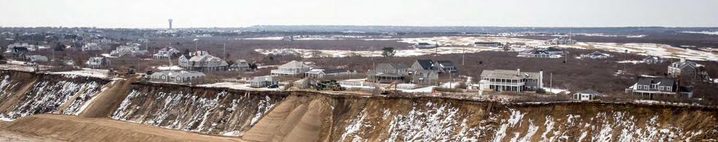
4 Sconset Bluff feet tall Glacial origin Denuded (prior to 2015) Narrow fronting beach Vulnerable to wave attack


5 Sconset Bluff and Storm Waves


6 Community Setting Area known as Siasconset (Sconset) Many historic homes built in late 1800 s and early 1900 s Served by a single accessway known as Baxter Road Sankaty Light

7 Erosion History Sconset Bluff began eroding in the 1970 s Erosion is progressing from north to south Group of residents formed Sconset Beach Preservation Fund (SBPF)


8 Coastal Bank Retreat Long-Term Average: 4.6 feet/year Potential Single Season Loss: feet/year Winter resulted in catastrophic erosion 8


9 Existing Conditions (June 2013) Baxter Road Baxter Road Baxter Road, homes, and associated utilities (water/sewer) in imminent danger Geotechnical engineer advised closure of road when within 25 feet of bluff edge Town of Nantucket has legal obligation to provide access to homes Town of Nantucket and SBPF entered partnership to sponsor erosion control project

 Beach nourishment (applied")
 Biodegradable")

10 Alternatives Many alternatives evaluated in theory and in practice since the 1990 s: Managed retreat (house moves) Beach dewatering (installed in 2000 inconsistent results) Beach nourishment (applied not approved) Marine mattresses and gabions (applied 2010 not approved) Biodegradable bags or envelopes (utilized since mid s useful in smaller storms but not effective in major or successive storms) 10
, ease of")


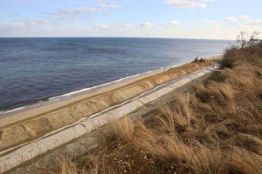
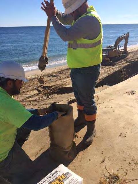
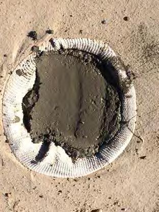
11 Geotextile Tube Project Preferred due to ability to withstand storm waves, sloped design (decreases wave reflection), ease of installation and, if necessary, removal. Fabricated from high strength, woven polypropylene sewn into a tube shape. Three-four rows of 45 circumference geotextile tubes, each about 19 wide, 7 tall, and long. Two phases of construction: three tiers installed in December 2013/January 2014; fourth tier and returns installed October through December Total length 947 feet.


12 Construction of Geotextile Tube Project December 2013/January 2014

13
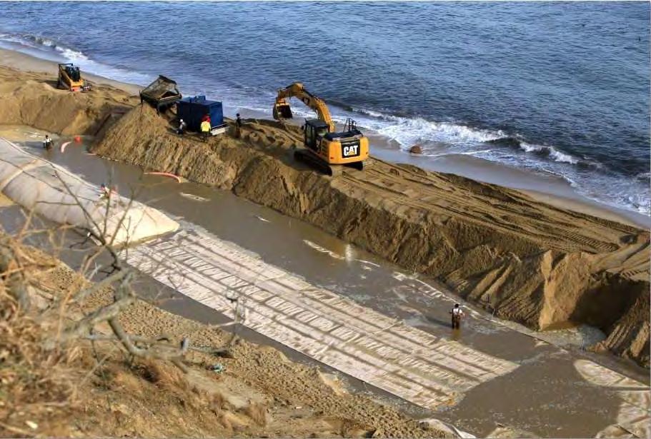
14
15

16

17 Construction of 4 th Tier Geotextile Tube Project Fall 2015


18 Construction of 4 th Tier Geotextile Tube Project

19 Construction of 4 th Tier Geotextile Tube Project


20 Construction of 4 th Tier Geotextile Tube Project
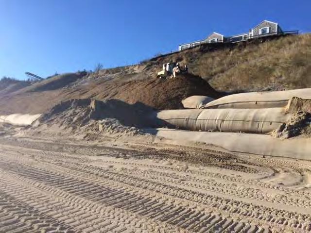
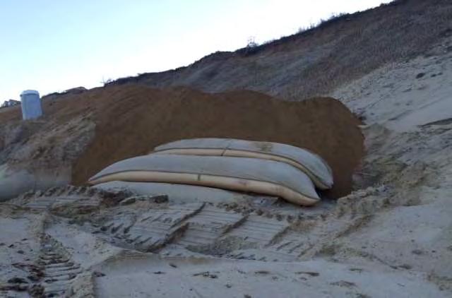
21 Construction of 4 th Tier Geotextile Tube Project
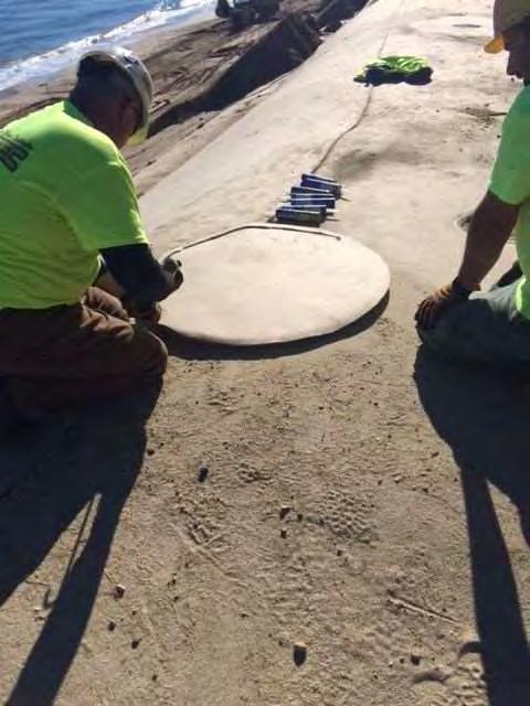
22 Sand Mitigation August 2015 Protection of bluff prevents it from serving as a sediment source and requires mitigation Massachusetts typically requires annual mitigation equivalent to average annual contribution Project provides 22 cy/lf/yr, which is equal to 1.5 times average annual bank contribution Total volume ~20,000 cy sand/yr May 2015 June 2016

23 Sand Delivery Sand brought to the site by dump truck from on-island pits Sand delivery occurs during off-season months only

24 Sand Delivery


25 How Geotextile Tubes Work 2. The sand cover on the geotubes is washed away, contributing sand like the natural bluff would. 1. Wave runup during storms hits the base of the geotubes instead of the base of the bluff. 3. The sand template on the geotubes is regraded so the tubes are covered.


26 Vegetation Once the base of the bluff was protected by the geotextile tubes, the face of the bluff could also be stabilized by adding vegetation. Vegetation helps to prevent erosion from wind, rain, and stormwater runoff. American Beachgrass planted in spring 2015; additional planting occurred in spring 2016 above the new returns.


27 Stormwater Drainage System Top and face of bluff can erode from wind, rain, and stormwater runoff. In January and February 2016, a drainage system was installed on Baxter Road. This drainage system serves to capture stormwater runoff and redirect it, so that it no longer causes erosion from the top of the bluff. Berm installed along roadway where needed to redirect stormwater runoff away from the face of the bluff. June 2016


28 Monitoring Project is extensively monitored, including: Annual Bluff Monitoring Quarterly Shoreline Monitoring Wetland Well Monitoring Annual Beach Invertebrate Monitoring Semi-annual Underwater Video Monitoring Annual Drainage System Report Annual Sand Delivery Report

29 Monitoring - Key Findings Geotube system in place since Jan 2014 nearly 3.5 years/4 winters Base of bluff has been stabilized by the geotextile tubes. Shoreline monitoring data shows shoreline is within range of expected positions based on historic data, with no indication of accelerated erosion in front of or adjacent to the geotubes bluff survey indicates that mitigation sand template is contributing more than the historic contribution rate and the unprotected bluff. No indication of adverse effect noted in beach invertebrate monitoring, wetland well monitoring, or underwater video monitoring. May 2017 June 2016
30 Annual Aerial Survey of Bluff The first annual aerial survey was performed of the Project area on April 2, Second annual survey just completed late May The results of the 2016 aerial survey were compared to the 2013 aerial survey for those unprotected areas immediately adjacent to the geotextile tube project. Unprotected bluff contribution volume was 12.9 cy/lf/yr, which is 59% of mitigation volume. To the North: 800 ft unprotected bluff Bluff Volume Loss in Unprotected Areas Adjacent to Geotextile Tubes Line Area Volume Lost (CY) Length (Feet) Duration (Years) Erosion Rate (CY/LF/YR) 1 North Unprotected Area 31, South Unprotected Area 4, Total Bluff Erosion for Adjacent Unprotected Areas 35,699 1,
31 Summary Geotube Area ( ): At least 22 cy/lf/yr sand delivered 18.1 cy/lf/yr contributed 14.8 cy/lf in template as of April 2016 Unprotected Bluff Areas ( ): 12.9 cy/lf/yr contributed
32 Shoreline Monitoring Shoreline monitoring at 46 transects along 6 miles of shoreline conducted quarterly Shoreline monitoring measures: Change in position of the shoreline (MLW line) and Change in volume Bathymetry (-5 MLW out to 3,000 feet offshore or -35 MLW isobath) conducted in the spring and fall >20 years of historical data No indication of any adverse effect from the geotextile tubes.

33 Underwater Video Monitoring Underwater video monitoring at 10 transects immediately seaward of geotextile tubes and adjacent areas
. TR-400 9.")
. TR-1020. 14.")
.")


.")
34 Underwater Video Monitoring October 2016 June October 5. Sand Waves or Ripples 95%, Pebbles 5%). TR (Flat Sand 30%, Pebble 5%, Cobble 30%, Boulder 35%). TR (Pebble 100%). TR (Flat Sand 15%, Pebble 50%, Cobble 35%). TR (Flat Sand 45%, Pebble 15%, Cobble 10%, Boulder 30%). TR (Flat Sand 30%, Pebble 50%, Cobble 20%). TR Biota: June and October identified invertebrate species, fish species, and marine plant and algal species, with some seasonal variability (spider crabs bury into sediments; black sea bass, scup, and skates move offshore). Branching brown and red algae, bread crumb sponge, and rock crab were dominant biota. No indication of adverse effect on marine biota.

35 Underwater Video Monitoring Monitoring shows continued prevalence of cobble/bottom habitat located directly offshore of the geotextile tube Project, with no indication that cobble/boulder habitat is being covered by the mitigation sand.


36 Monitoring Conclusions Geotextile tubes have stabilized the base of the bluff. Mitigation sand from the project has contributed more sand than the historic erosion rate and the recent contribution from the unprotected bluff. Shoreline monitoring data shows no indication of accelerated erosion within or directly adjacent to geotextile tubes. No evidence of harm observed in wetland well monitoring, beach invertebrate monitoring, and underwater video monitoring.


37 Next Steps Expand current system to 3400 ft May 2017 Review sand source options Review monitoring program to focus on collecting most useful data Review mitigation program to consider more adaptive approach
38 Questions? Photo credits: George Riethof and the Sconset Trust, Rick Blair, Rob Benchley Maria Hartnett, Associate
Options for Managing Coastal Erosion. Presentation by: Ashley Sprague
 Options for Managing Coastal Erosion Presentation by: Ashley Sprague Shoreline stabilization methods Armouring - Boulders/rockwalls most common method of erosion control in Nova Scotia Concerns: - Accelerate
Adaptive Management Strategies for Resilient Coastlines: A Case Study on the Ft. Pierce, FL Breakwater Project
 Adaptive Management Strategies for Resilient Coastlines: A Case Study on the Ft. Pierce, FL Breakwater Project USACE Workshop November 21 st, 2013 By: Jenna Phillips Emphasis on Green or Nature-Based Engineering
BEACH AND INLET PROJECTS UPDATE
 BEACH AND INLET PROJECTS UPDATE USACE DELTA PROJECT USACE Delta Project Project Extents Elevation Elevation (ft NAVD88) (ft NAVD88) USACE Delta Project Project Cross-Section 20 18 20 16 18 14 16 12 14
Karen A. Duhring Marine Advisory Scientist Center for Coastal Resources Management Virginia Institute of Marine Science College of William & Mary
 Karen A. Duhring Marine Advisory Scientist Center for Coastal Resources Management Virginia Institute of Marine Science College of William & Mary March 20, 2009 Low-Impact Shoreline Stabilization Cumulative
Green or Grey Solutions? Why not both? Lessons from the Mid-Atlantic on Hybrid Living Shorelines
 Green or Grey Solutions? Why not both? Lessons from the Mid-Atlantic on Hybrid Living Shorelines Proactive By Design. Our Company Commitment Jesse Baldwin Coastal Geologist Project Manager GZA GeoEnvironmental,
Empowering Local Action for Coastal Resilience in Massachusetts. Bruce K. Carlisle MA Office of Coastal Zone Management
 Empowering Local Action for Coastal Resilience in Massachusetts Bruce K. Carlisle MA Office of Coastal Zone Management Context Coastal communities continue to face both chronic and acute storm surge, erosion,
Living Shorelines in Virginia: What s Happened Since the 2006 Living Shorelines Summit?
 Living Shorelines in Virginia: What s Happened Since the 2006 Living Shorelines Summit? Karen Duhring Center for Coastal Resources Management Virginia Institute of Marine Science College of William & Mary
Improvement of the Atlantic Coast of New York City,
 Improvement of the Atlantic Coast of New York City, Rockaway Inlet to Norton Point Project at Sea Gate Meeting Purpose The U.S. Army Corps of Engineers, the New York State Department of Environmental Conservation,
Executive Office of Energy and Environmental Affairs Massachusetts Vulnerability Preparedness Program. June 6, 2018
 Executive Office of Energy and Environmental Affairs Massachusetts Vulnerability Preparedness Program June 6, 2018 Presentation Outline: 1. What Natural Hazards Impact Falmouth 2. Coastal Resiliency Efforts
Natural Shoreline Landscapes on Michigan Inland Lakes. Introduction. Workshop for Property Owners. Photo by Jane Herbert
 Natural Shoreline Landscapes on Michigan Inland Lakes Workshop for Property Owners Introduction Photo by Jane Herbert MSU is an affirmative action, equalopportunity employer. Michigan State University
Appendix to Amicus Curiae Brief: Selected Provisions of the South Carolina Beachfront Management Act
 Loyola Marymount University and Loyola Law School Digital Commons at Loyola Marymount University and Loyola Law School Loyola of Los Angeles Law Review Law Reviews 6-1-1992 Appendix to Amicus Curiae Brief:
511 - RIP RAP - OPSS 511 ROCK PROTECTION - OPSS 511 GRAVEL SHEETING - OPSS 511 GEOTEXTILE - OPSS 511
 511 - - OPSS 511 ROCK PROTECTION - OPSS 511 GRAVEL SHEETING - OPSS 511 GEOTEXTILE - OPSS 511 511.1 GENERAL 511.1.1 Rip Rap 511.1.2 Rock Protection Excavation for placing Rip Rap, Rock Protection and Gravel
North Carolina Coastal Federation
 North Carolina Coastal Federation Erosion Control: Non-Structural Alternatives A Shorefront Property Owner s Guide Shoreline erosion and landward migration of marshes are natural processes, and are important
Banking on Natural Fibers Products made from coir and jute play a key role in stabilizing a restored stream for a commercial stream mitigation bank.
 Banking on Natural Fibers Products made from coir and jute play a key role in stabilizing a restored stream for a commercial stream mitigation bank. By Greg Northcutt When White Creek Mitigation, LLC,
Living Shoreline Professionals Advanced Training. August 24 & 31, 2017 Hosted by Virginia Institute of Marine Science College of William & Mary
 Living Shoreline Professionals Advanced Training August 24 & 31, 2017 Hosted by Virginia Institute of Marine Science College of William & Mary LIVING SHORELINE PROFESSIONALS ADVANCED TRAINING AUGUST 2017
Applications of Coir Fibre Products in Environmental Erosion & Sediment Control and Restoration
 Applications of Coir Fibre Products in Environmental Erosion & Sediment Control and Restoration Calista R. Santha, Ph.D. Lanka Santha, P.E. RoLanka International, Inc. Stockbridge, GA, USA Coir Fibre Abundant,
Engineering of Dunes. Protection Benefits of Coastal Sand Dunes. FEMA Dune Standards
 Engineering of Dunes Protection Benefits of Coastal Sand Dunes In addition to providing habitat for a variety of species, coastal sand dunes are an integral part of a wellplanned coastal defense system.
RESILIENCY, ADAPTATION, & SUSTAINABILITY AT THE CITY OF ST. AUGUSTINE
 RESILIENCY, ADAPTATION, & SUSTAINABILITY AT THE CITY OF ST. AUGUSTINE PROGRAM UPDATE JANUARY 14, 2019 MICHAEL G. CULLUM, P.E. DIRECTOR, PUBLIC WORKS PROGRESSION OF PLANNING FOR RESILIENCY / ADAPTATION
Goals and Strategies. Goals. Strategies. Long-term Beach and Shoreline Management Program
 Goals and Strategies Goals Long-term Beach and Shoreline Management Program Qualify for and Maintain Static-line Exception Qualify for and Maintain FEMA Engineered Beach Lockwoods Folly Inlet Management
There is an ongoing regulatory concern that
 FWRJ Alternatives for Beach Stormwater Outfalls: Preliminary Assessment for City of Naples Reshma Thummadi, Ronald Cavalieri, Andy Holland, and Gregg Strakaluse There is an ongoing regulatory concern that
CHAPTER Committee Substitute for Senate Bill No. 1472
 CHAPTER 2007-99 Committee Substitute for Senate Bill No. 1472 An act relating to beaches and shores; amending s. 161.021, F.S.; amending a definition; amending s. 161.085, F.S.; restricting the use of
Dauphin Island s East End Beach and Barrier Island Restoration Project. April 16, :00 PM Dauphin Island Sea Lab, Shelby Hall
 Dauphin Island s East End Beach and Barrier Island Restoration Project Town of Dauphin Island, Alabama April 16, 2015 6:00 PM Dauphin Island Sea Lab, Shelby Hall Team Introduction South Coast Engineers
Scarborough Waterfront Project
 Scarborough Waterfront Project Public Information Centre #1 Environmental Assessment Terms of Reference September 10, 2014 Agenda Open House Presentation 7:00 to 7:30 pm Presentation 7:30 to 8:15 pm History
Coastal Erosion Commission: context, examples, and next steps
 Coastal Erosion Commission: context, examples, and next steps Overview Themes from other national and state level reports 2007 MA Coastal Hazards Commission Best practices and examples Financial i and
5 TH ANNUAL CAPE COASTAL CONFERENCE
 5 TH ANNUAL CAPE COASTAL CONFERENCE Key Considerations for Living Shoreline Projects Seth Wilkinson, Restoration Ecologist, President Wilkinson Ecological Design, Inc. BIOENGINEERING STRATEGIES Reducing
2013 Summer Recap. Rockaway Beach
 2013 Summer Recap and Discussion on Rockaway Beach Reconstruction Tonight s Agenda Summer Beach Update Phase 2 Assumptions, Constraints and Regulations Rebuilding the Boardwalk Coastal Protection Rockaway
Habitat Improvements to the Motor Island Shoreline in the Upper Niagara River, NY: A Collaborative Approach
 Habitat Improvements to the Motor Island Shoreline in the Upper Niagara River, NY: A Collaborative Approach Edward Alkiewicz 1, Stephen Schoenwiesner 1, Jeff Gerlach 1, Morris Perot 2, Scott Ault 2, Mark
Sierra Club Comments on ACOE Public Notice NAE Re: Proposed Town Neck Beach Project at Sandwich, Massachusetts
 August 27, 2015 US Army Corps of Engineers New England District 696 Virginia Road Concord, MA 01742-2751 Attn: Phillip W. Nimeskern Dear Mr. Nimeskern, Sierra Club Comments on ACOE Public Notice NAE-2014-259
ALTERNATIVE SHORELINE MANAGEMENT IN COASTAL MISSISSIPPI
 ALTERNATIVE SHORELINE MANAGEMENT IN COASTAL MISSISSIPPI Project supported via financial assistance provided by the Coastal Zone Management Act of 1972, as amended, administered by the Office of the Ocean
Post Construction BMPs
 Post Construction BMPs Why are Post Construction BMPs important? With increased development brings the increase of impervious cover Parking lots, rooftops, driveways Storm water runoff volume increases
Coastal and River Erosion Control. Erosion
 Coastal and River Erosion Control Erosion Definition: Erosion is the process by which individual soil particles are dislodged from the soil mass and carried away by a transporting medium. The soil erosion
What Are Some Ways Erosion Can Be Managed?
 Learning Set 3 The Basketball-Court Challenge 3.5 Case Studies What Are Some Ways Erosion Can Be Managed? Name: Case name Case description (include problem) Case solution (describe and sketch) You are
Natural & Nature-Based Solutions for Risk Reduction & Resilience
 University of Massachusetts Amherst ScholarWorks@UMass Amherst International Conference on Engineering and Ecohydrology for Fish Passage International Conference on Engineering and Ecohydrology for Fish
Welcome. Tannery and Waterworks Parks Shoreline Improvements Environmental Assessment. Public Information Centre #1 November 27, pm to 8 pm
 Welcome Tannery and Waterworks Parks Shoreline Improvements, Environmental Assessment Tannery and Waterworks Parks Shoreline Improvements Environmental Assessment #1 6 pm to 8 pm Why We Are Here Tannery
Town of Vershire Road Erosion Inventory Report
 Town of Vershire Road Erosion Inventory Report Taylor Valley Road. Photo taken by TRORC staff. Prepared by: 128 King Farm Road Woodstock, VT 05091 Inventory and report funded by the Vermont Agency of Transportation
Building a Rain Garden in Colorado. Created By:
 Building a Rain Garden in Colorado Created By: Table of Contents What is a Rain Garden?...3 Why are they Important...3 Choosing a Location...4 Sizing Your Rain Garden...5 Layout...7 Additional materials...7
GEOSYNTHETICS ENGINEERING: IN THEORY AND PRACTICE
 GEOSYNTHETICS ENGINEERING: IN THEORY AND PRACTICE Prof. J. N. Mandal Department of Civil Engineering, IIT Bombay, Powai, Mumbai 400076, India. Tel.022-25767328 email: cejnm@civil.iitb.ac.in Module-11 LECTURE-
The use of low head weirs to. perennial streams with their floodplains:
 The use of low head weirs to reconnect severely entrenched perennial streams with their floodplains: An Anne Arundel County TMDL Watershed Implementation Plan Strategy presented by Hala Flores, P.E Mid
Use of Best Management Practices
 Use of Best Management Practices Presented at the ANJEC Flood Hazard Workshop Bordentown, NJ March 13, 2008 Stormwater BMPs "a technique, measure or structural control that is used for a given set of conditions
Peoria Riverfront Development (Ecosystem Restoration) Upper Mid-sized Island Critical Restoration Project (September 2011)
 Upper Mid-sized Island Critical Restoration Project (September 2011)") Peoria Riverfront Development (Ecosystem Restoration) Upper Mid-sized Island Critical Restoration Project (September 2011) Description The Corps of Engineers, Rock Island District (District) and the Illinois
Peoria Riverfront Development (Ecosystem Restoration) Upper Mid-sized Island Critical Restoration Project (September 2011) Description The Corps of Engineers, Rock Island District (District) and the Illinois
Coffee Creek Park Development Low Impact Development (LID)
") Coffee Creek Park Development Low Impact Development (LID) City of Duluth, St. Louis County, MN Presented By: Christopher J. Rousseau, P.E. February 27, 2008 Developer / Owner Information Trinity Development
Coffee Creek Park Development Low Impact Development (LID) City of Duluth, St. Louis County, MN Presented By: Christopher J. Rousseau, P.E. February 27, 2008 Developer / Owner Information Trinity Development
Homeowners Guide to Stormwater BMP Maintenance
 Homeowners Guide to Stormwater BMP Maintenance What You Need to Know to Take Care of Your Property Rain Barrel Dry Well Rain Garden Pervious Asphalt Porous Pavers City of El Monte Stormwater BMP Management
ADDENDUM TO BIOLOGICAL SCOPING SURVEY REPORT, BOTANICAL SURVEY AND WETLAND DELINEATION
 ADDENDUM TO BIOLOGICAL SCOPING SURVEY REPORT, BOTANICAL SURVEY AND WETLAND DELINEATION FOR AVALON INN (APN 069-241-27 & -04) 1201 & 1211 NORTH MAIN STREET FORT BRAGG, CA MENDOCINO COUNTY prepared for:
Erosion Control for Home Builders in the. City of Jacksonville
 Erosion Control for Home Builders in the City of Jacksonville Eroding construction sites are a leading cause of water quality problems in Jacksonville. For every acre under construction, about a dump truck
A comparison of Traditional and Prefabricated Encapsulated Soil Lifts
 A comparison of Traditional and Prefabricated Encapsulated Soil Lifts Jane Herbert, Senior Extension Educator 2014 Wisconsin Lakes Convention Background on shoreline erosion control in MI KBS Shoreline
ENBRIDGE GAS DISTRIBUTION INC. Proposed Relocation for Ninth Line, Markham and Whitchurch-Stouffville. Environmental Screening Report
 Page 1 of 18 ENBRIDGE GAS DISTRIBUTION INC. Proposed Relocation for Ninth Line, Markham and Whitchurch-Stouffville Environmental Screening Report July 2011 Page 2 of 18 Table of Contents 1.0 INTRODUCTION
Construction Progress Report
 Report Date: 4/8/2017 Subject: Construction Week 2 70% Complete Project: Sunset Pond EWP Stream Reclamation, Fourmile Creek, Boulder County, CO Report By: TJ Burr, Civil Engineer/Stream Restoration Specialist,
Weston s Wetlands, Stormwater, & Open Space
 Weston s Wetlands, Stormwater, & Open Space Weston s Wetlands, Stormwater, & Open Space Conservation Commission Role and Responsibilities Laws that protect wetlands What residents can do to protect wetlands
Information for File # ARC
 Information for File # 2016-02630-ARC Applicant Corps Contact Will Bomier-Carlton County Transportation Department Andrew R Chambers Address 600 South Lake Avenue, Suite 211, Duluth, MN 55802 E-Mail Andrew.R.Chambers@usace.army.mil
OLD BUSINESS NEW BUSINESS A. JIM CONWAY 2016-WTRA B. KENNETH CALISE 2016-WTRA C. SAGIE DORON 2016-WTRA-00060
 May 12, 2016 TO: Wetlands Board Members FROM: Richard W. Scarper RE: May, 2016 Wetlands Board Applications Attached are the Planning Department's administrative comments for the following wetlands/dunes
Soil Erosion & Sediment Control Plan Requirements for Submittal to the Cape Atlantic Conservation District
 Soil Erosion & Sediment Control Plan Requirements for Submittal to the Cape Atlantic Conservation District The following is a list of the minimum requirements required on Soil Erosion and Sediment Control
Memorandum Planning. Thursday, January 8, 2015
 Memorandum Planning Thursday, January 8, 2015 7.A. To: Coastal Advisory Committee From John Ciampa, Associate Planner Subject: Review Draft Local Coastal Program Copies: James Pechous, City Planner Purpose
Hydrologic Assessment of using Low Impact Development to Mitigate the Impacts of Climate Change. Chris Jensen, AScT Master of Science Thesis
 Hydrologic Assessment of using Low Impact Development to Mitigate the Impacts of Climate Change Chris Jensen, AScT Master of Science Thesis Bowker Creek Initiative April 12, 2012 Outline 1. Future Impacts
STAFF REPORT FOR STANDARD COASTAL DEVELOPMENT PERMIT #CDP FEBRUARY 26, 2015 CPA - 1 PO BOX 238 APTOS, CA 94001
 STAFF REPORT FOR STANDARD COASTAL DEVELOPMENT PERMIT #CDP 2014-0030 FEBRUARY 26, 2015 CPA - 1 OWNER/APPLICANT: AGENT: REQUEST: HANS HEIM PO BOX 238 APTOS, CA 94001 JAMES HAY PO BOX 762 MENDOCINO, CA 95460
EROSION CONTROL Professional Development Training. Sean Crimmins, President Brian Barker, Southeastern Consultant
 EROSION CONTROL Professional Development Training Sean Crimmins, President Brian Barker, Southeastern Consultant What is TPG GREEN SOLUTIONS -- and Who is involved? What does TPG GREEN SOLUTIONS offer?
Lake Nokomis Shoreline Enhancement Project
 Lake Nokomis Shoreline Enhancement Project Community Meeting 2 February 13, 2018 Agenda Current Problems Project Goals Project Status Existing Conditions Community Input Draft Schematic Design Long-term
EROSION & SEDIMENT CONTROL
 EROSION & SEDIMENT CONTROL 1 EROSION & SEDIMENT CONTROL Effective Soil & Water Protection Whether you want to prevent soil erosion caused by rain, water and wind, or protect waterways from inevitable build
REVETMENT WORKS- MUSKERS BEACH
 REVETMENT WORKS- MUSKERS BEACH Presented by: Arvind Singh Coordinator Infrastructure Projects, Livingstone Shire Council Chris Lancaster Geofabrics Australasia Pty. Ltd. Presentation Topics 1. Background
QUESTIONS AND ANSWERS Windsor Woods, Princess Anne Plaza & The Lakes Combined Drainage Project
 QUESTIONS AND ANSWERS Windsor Woods, Princess Anne Plaza & The Lakes Combined Drainage Project Project Overview... 2 Thalia Creek (Windsor Woods) Tide Gate... 6 Club House Road Drainage Project... 9 Updated
PERMANENT SEEDING. Overview of Sedimentation and Erosion Control Practices. Practice no. 6.11
 Overview of Sedimentation and Erosion Control Practices Practice no. 6.11 PERMANENT SEEDING Permanent vegetation controls erosion by physically protecting a bare soil surface from raindrop impact, flowing
Activity Residential Site Planning
 Activity 2.3.7 Residential Site Planning Introduction When a building is designed apart from a specific site, an opportunity is lost to match the design to the strengths and weaknesses of the site. To
Information for File # JTF
 Information for File # 2013-04665-JTF Applicant Corps Contact Enbridge Energy, Limited Partnership Josh Fitzpatrick Address 1554 Highway 2, Suite 2, Two Harbors, MN 55616 E-Mail joshua.t.fitzpatrick@usace.army.mil
July 22, 2013 REQUEST FOR PROPOSALS TO PROVIDE ENGINEERING DESIGN SERVICES FOR A PROJECT ALONG THE WESTERN SHORE OF MOBILE BAY
 Mobile Bay National Estuary Program 4172 Commanders Drive Mobile, AL 36615 Phone: 251-431-6409 Fax: 251-431-6450 Contact: Tom Herder, Watershed Protection Coordinator Email: therder@mobilebaynep.com July
PRE-DESIGN CONCEPT REPORT GRAND CANAL RESTORATION
 PRE-DESIGN CONCEPT REPORT GRAND CANAL RESTORATION Project Background November 19, 2007 Executive Summary The Grand Canal is an important tidal waterway in the Venice community of Los Angeles, California,
MANUAL OF DESIGN, INSTALLATION, AND MAINTENANCE REQUIREMENTS FOR STORMWATER MANAGEMENT PLANS
 MANUAL OF DESIGN, INSTALLATION, AND MAINTENANCE REQUIREMENTS FOR STORMWATER MANAGEMENT PLANS May 2007 SECTION 1 Responsibility of Applicant TABLE OF CONTENTS A. Stormwater Management Plan Required Information
North Branch of Cypress Creek Ecological Restoration: A Comprehensive Approach to Stream Restoration
 North Branch of Cypress Creek Ecological Restoration: A Comprehensive Approach to Stream Restoration Rocky Powell Clear Creeks Consulting, LLC Keith D. Tate, P.E. BayLand Consultants & Designers, Inc.
Could this be a concrete solution to biodiversity loss?
 Could this be a concrete solution to biodiversity loss? JUST BUILT NEW HOMES Hot offer Authors: Louise Firth, Ally Evans, Antony Knights, Róisín Nash, Keith Browne, Pippa Moore, Elisabeth Morris-Webb,
Nick Sigmund, Sr. Zoning Officer
 Nick Sigmund, Sr. Zoning Officer Wisconsin Department of Natural Resources Administrative Code NR 115 under the authority of Wisconsin Statute 59.692, establishes and provides that shoreland zoning regulations
NC Coastal Management Program Update. Mike Lopazanski Policy & Planning Section Chief April 3, 2015
 NC Coastal Management Program Update Mike Lopazanski Policy & Planning Section Chief April 3, 2015 NC Coastal Area Management Act (1974) Balances competing coastal pressures through development permitting
HUDSON VALLEY REGIONAL COUNCIL 3 Washington Center, Newburgh NY
 PROJECT AREA: HYDE PARK HUDSON VALLEY REGIONAL COUNCIL 3 Washington Center, Newburgh NY 12550 http://www.hudsonvalleyregionalcouncil Insert aerial site photo with streets labeled GREEN INFRASTRUCTURE CONCEPT
Eco-engineering of artificial coastal structures to reduce their impact on the surrounding environment
 Eco-engineering of artificial coastal structures to reduce their impact on the surrounding environment Urban Research on Biodiversity on Artificial and Natural coastal Environments: Enhancing biodiversity
Hunts Point Landing, Bronx, New York
 Hunts Point Landing, Bronx, New York Sustainable Shorelines in an Urban Environment John Roebig, PhD. HDR Engineering, Inc. John.Roebig@hdrinc.com Promoting Resilient Shorelines along the Hudson River
Managing Shorelines: Control Erosion and Protect Water Quality. Ben Powell Clemson Extension
 Managing Shorelines: Control Erosion and Protect Water Quality Ben Powell Clemson Extension Importance of Stabile Shoreline Erosion = loss of real estate Erosion unsightly = reduced property value
PURPOSE: The purpose is to provide commercial facilities in the Vancouver and Clark County vicinity.
 US Army Corps of Engineers Seattle District Joint Public Notice Application for a Department of the Army Permit and a Washington Department of Ecology Water Quality Certification and/or Coastal Zone Management
River Mile 10.9 Removal Action Overview
 River Mile 10.9 Removal Action Overview November 13, 2014 CAG Meeting Modified from CPG s RM10.9 Removal Action Final Design Report dated Nov. 2013 1 River Mile 10.9 Removal Action Activities Dredging:
An Integrated Approach for Water Management Examples from The Netherlands. Addressing Climate Change and Sea Level Rise
 An Integrated Approach for Water Management Examples from The Netherlands Addressing Climate Change and Sea Level Rise Superstorm Sandy Forum College of Staten Island March 8 2013 Water: a challenge and
EEA Capital Investment in Green Infrastructure
 EEA Capital Investment in Green Infrastructure Goal: Advance local efforts to implement measures to increase natural storm damage protection, flood control, and community resilience State capital funding
B511 - RIP-RAP, ROCK PROTECTION AND GRANULAR SHEETING - OPSS 511
 B511 - - OPSS 511 511.1 GENERAL 511.1.1 Rip-Rap Excavation for placing rip-rap, rock protection, and granular sheeting is part of each individual tender item. Rip-rap is a special application of rock protection.
Rhode Island Shoreline Change Special Area Management Plan
 Rhode Island Shoreline Change Special Area Management Plan Draft Document Outline REVISED 10/12/2017 VOLUME 1 Executive Summary & How to Use this Document (Draft by Dec 2017) 1. Introduction (Revised draft
Coastal Construction Setback Line Review
 City of New Smyrna Beach City Council Meeting January 23, 2018 Scope of Work Comparison of the City's Coastal Construction Setback Line (CCSL) to that of the Florida Department of Environmental Protection
A: Downtown Diversion Pipe
 A: Downtown Diversion Pipe b c with modifications Map highlighting conservation easement. The diversion pipe would run along the railroad. Will divert 40-44% of total flow.; and Reduce the impact on Sand
SHORE PROTECTION ACT STAFF S FINDINGS & RECOMMENDATIONS
 SHORE PROTECTION ACT STAFF S FINDINGS & RECOMMENDATIONS TO: FROM: Shore Protection Committee: Commissioner Mark Williams, Chairman Mr. Richard Gardner Mr. Henry Morgan Mr. Zach Harris Mr. Bill Hodges Department
Grand River Ravines Georgetown Township
 Grand River Ravines Georgetown Township Project Description: The Grand River Ravines County Park property is composed of the 68-acre former Fillmore at the Bend Open Space purchased in 1999 and two more
CITY OF TUMWATER 555 ISRAEL RD. SW, TUMWATER, WA (360) (360) (FAX)
 (360) (FAX)") CITY OF TUMWATER 555 ISRAEL RD. SW, TUMWATER, WA 98501 (360) 754-4180 (360) 754-4126 (FAX) Email: cdd@ci.tumwater.wa.us APPENDIX II-C SHORT FORM CONSTRUCTION STORMWATER POLLUTION PREVENTION PLAN (SWPPP)
CITY OF TUMWATER 555 ISRAEL RD. SW, TUMWATER, WA 98501 (360) 754-4180 (360) 754-4126 (FAX) Email: cdd@ci.tumwater.wa.us APPENDIX II-C SHORT FORM CONSTRUCTION STORMWATER POLLUTION PREVENTION PLAN (SWPPP)
SOP 6: Erosion and Sedimentation Control SOP 6: EROSION AND SEDIMENTATION CONTROL
 Standard Operating Procedures Central Massachusetts Regional Stormwater Coalition SOP 6: Erosion and Sedimentation Control SOP 6: EROSION AND SEDIMENTATION CONTROL Erosion and sedimentation from land-disturbing
Broward County Coastal Engineering Consultant Services For Segment III Shore Protection T P1 R. Harvey Sasso, P.E. Danielle Irwin, CFM
 Coastal Systems International, Inc. Broward County Coastal Engineering Consultant Services For Segment III Shore Protection T2112588P1 R. Harvey Sasso, P.E. Danielle Irwin, CFM Experts in Coastal Engineering,
Decision Notice. Proposed Action
 Decision Notice Paving Weld County Road 105 USDA Forest Service Arapaho and Roosevelt National Forest and Pawnee National Grassland Pawnee National Grassland Ranger District Weld County, Colorado November
KENT COUNTY STORMWATER MAINTENANCE DISTRICT STORMWATER BMPs MAINTENANCE TASKS AND RESPONSIBILITIES GUIDANCE DOCUMENT BIO-RETENTION FACILITIES
 BIO-RETENTION FACILITIES (for all basins / BMPs) Annually Prepare Operation and Maintenance Plan. Clearly outline how vegetation in the facility and its buffer area will be managed or harvested in the
.MANAGED RETREAT. Need for managed retreat
 602 MANAGED RETREAT hazards. This strategy is based on a philosophy of moving out of harm's way, and is proactive in recognizing that the dynamics of the coastal zone should dictate the type of management
CHATHAM COUNTY S PATH TO SUSTAINABILITY - THE NATURAL RESOURCES SIDE
 CHATHAM COUNTY S PATH TO SUSTAINABILITY - THE NATURAL RESOURCES SIDE GEORGIA ENVIRONMENTAL CONFERENCE SAVANNAH, GEORGIA AUGUST 23, 2012 Jackie Jackson Teel Chatham County-Savannah Metropolitan Planning
Landowner's Guide to the Lower St. Croix Riverway. Protect. Restore. Celebrate. stcroixriverassociation.org
 Landowner's Guide to the Lower St. Croix Riverway Protect. Restore. Celebrate. stcroixriverassociation.org Cover and page spread photographs by Craig Blacklock. For more information on how to be a river
Town of Corinth Road Erosion Inventory Report
 Town of Corinth Road Erosion Inventory Report Grist Mill Road. Photo taken by TRORC staff. Prepared by: 128 King Farm Road Woodstock, VT 05091 Inventory and report funded by the Vermont Agency of Transportation
Structural Storm Water Best Management Practices (BMPs)
") Structural Storm Water Best Management Practices (BMPs) Storm Water Permitting: The SWPPP Revealed By Deron Austin, PE January 11, 2006 3:30-5:00 PM Orlando, Florida Presentation Outline Preface About
Structural Storm Water Best Management Practices (BMPs) Storm Water Permitting: The SWPPP Revealed By Deron Austin, PE January 11, 2006 3:30-5:00 PM Orlando, Florida Presentation Outline Preface About
New York City, 19 th c.
 New York City, 19 th c. Lower Manhattan, circa 1930s Westside Highway, Manhattan, circa 1940s Greenpoint Terminal Market, Brooklyn TRANSFORMATIONS ON THE WATERFRONT Harlem River Park, Manhattan BEFORE
Broward County Shore Protection Project Segment II. Physical Monitoring Plan
 Broward County Shore Protection Project Segment II USACE File No. SAJ-1999-05545 Broward County Shore Protection Project -Segment II Submitted To: Florida Department of Environmental Protection Office
CONTROLLING COASTAL BLUFF GROUNDWATER
 CONTROLLING COASTAL BLUFF GROUNDWATER At the mention of coastal erosion, many people will think of stormwaves eating away at dunes or undercutting the base of coastal bluffs. Consequent ly, much time,
Natural Infrastructure for Coastal Resilience Unlocking Funding Resources
 Natural Infrastructure for Coastal Resilience Unlocking Funding Resources Siddharth Narayan University of California Santa Cruz / The Nature Conservancy Financing Climate- Safe, Resilient Infrastructure
Landfill Closure, Intermediate Cover & Post-Closure Care. Municipal League Meeting
 Landfill Closure, Intermediate Cover & Post-Closure Care Municipal League Meeting 9-7-17 Gated and Closed Landfill Gated means no longer accepting waste. Closed means gated and final cover has been installed
New York State Department of Environmental Conservation
 New York State Department of Environmental Conservation Division of Environmental Permits, Region 3 21 South Putt Comers Road, New Paltz, New York 12561-1620 Phone: (845) 256-3054 FAX (845) 255-4659 Website:
Royal River Youth Conservation Corps
 Royal River Youth Conservation Corps 2007 Summary Report What s Inside: Contributing Partners Introduction Summary of Accomplishments Map of Sites Descriptions and Photos of Work Completed in: Auburn Durham