HAYS RIDGE NEIGHBOURHOOD AREA STRUCTURE PLAN
|
|
|
- Shawn Craig
- 5 years ago
- Views:
Transcription
1 Melcor Developments Ltd. HAYS RIDGE NEIGHBOURHOOD AREA STRUCTURE PLAN CONSOLIDATED APRIL 2012
2 Hays Ridge Neighbourhood Area Structure Plan Office Consolidation April 2012 Prepared by: Current Planning Branch Sustainable Development City of Edmonton Bylaw was adopted by Council in April In April 2012, this document was consolidated by virtue of the incorporation of the following bylaws: Bylaw To adopt the Hays Ridge Neighbourhood Area Structure Plan Editor s Note: This is an office consolidation edition of Hays Ridge Neighbourhood Area Structure Plan, Bylaw 15902, as approved by City Council on April 16, For the sake of clarity, new maps and a standardised format were utilised in this Plan. All names of City departments have been standardised to reflect their present titles. Private owners names have been removed in accordance with the Freedom of Information and Protection of Privacy Act. Furthermore, all reasonable attempts were made to accurately reflect the original Bylaws. All text changes are noted in the right margin and are italicised where applicable. This office consolidation is intended for convenience only. In case of uncertainty, the reader is advised to consult the original Bylaws, available at the office of the City Clerk. City of Edmonton Sustainable Development
3 TABLE OF CONTENTS 1.0 ADMINISTRATION Purpose Authority Timeframe Interpretation Monitoring Amendments Orientation PLAN CONTEXT Location Background Land Ownership Site Context Topography Soils Natural Areas and Ecological Connectivity Wetlands Existing Land Uses Environmental Assessments Historical Resources Pipelines and Oil Well Sites Golf Course Lands Public Involvement LAND USE, TRANSPORTATION & SERVICING Land Use Concept & Population Statistics Vision Goals & Objectives...17 Page i.
4 TABLE OF CONTENTS (CONT D) 3.4 Policy Green Development Urban Design Ecology Environment Historical Resources Residential Parkland, Recreation Facilities & Schools Commercial Non-Participating Lands Requiring Further Study Transportation Pedestrian & Bicycle Circulation Transit Jagare Ridge Golf Club Infrastructure, Servicing & Staging Stormwater Management Facilities & Drainage Sanitary & Drainage Servicing Water Servicing Shallow Utilities Development Phasing Appendices Appendix 1 Appendix 2 Planning Policy Context Technical Studies List of Figures Figure 1 Location... Page 4 Figure 2 Context... Page 5 Figure 3 Land Ownership... Page 6 Figure 4 Site Contours... Page 8 Figure 5 Site Features... Page 9 Figure 6 Top-of-Bank... Page 11 Figure 7 Ecological Network... Page 12 Figure 8 Environmental Site Assessment Area... Page 13 Figure 9 Energy Resources... Page 15 Figure 10 Land Use Concept... Page 17 Figure 11 Pedestrian Network and Shared Use Paths... Page 25 Figure 12 Parkland, Recreation Facilities and Schools... Page 32 Page ii.
5 TABLE OF CONTENTS (CONT D) Figure 13 Transportation Network... Page 33 Figure 14 Storm Servicing... Page 43 Figure 15 Sanitary Servicing... Page 44 Figure 16 Water Servicing... Page 45 Figure 17 Phasing... Page 47 List of Tables Table 1 Land Ownership...Page 7 Table 2 Energy Resources Summary...Page 14 Table 3 Proposed Land Use Concept and Population Statistics...Page 18 Page iii.
6 1.0 ADMINISTRATION 1.1 Purpose The purpose of the Hays Ridge Neighbourhood Area Structure Plan (NASP) is to describe in detail a land use framework for the development and servicing of lands identified as Hays Ridge neighbourhood. The NASP addresses the following: the type, density, location and distribution of various land uses, including residential, commercial, parks and open space, public utilities and amenities; the transportation network within Hays Ridge as the network relates to the overall (Heritage Valley Servicing Concept Design Brief (SCDB) transportation objectives; a conceptual servicing scheme and the provision of utility services and infrastructure; the manner in which environmental features and natural areas will be incorporated within the neighbourhood fabric; the integration of the existing Jagare Ridge Golf Club into the Hays Ridge NASP including the preservation of the existing golf course and ponds for holes 8, 9, 14, 15, 16, 17, and 18 within the developable portion of the NASP, and the private golf course facilities within the Whitemud Creek Ravine valley lands; and the implementation and staging of development. The Hays Ridge NASP will be used as a tool to guide and evaluate future zoning, subdivision, and development of the lands within the neighbourhood in an orderly and effective manner. Over time, it is intended that the implementation of the Hays Ridge NASP objectives and principles will result in a healthy, sustainable neighbourhood. General development guidelines and developer imposed architectural controls will help to realize the vision of a well-planned and designed neighbourhood where people wish to reside. 1.2 Authority Amended by Editor The Hays Ridge NASP was adopted by Edmonton City Council on April 16, 2012 as Bylaw in accordance with Section 633 of the Municipal Government Act. 1.3 Timeframe Development in Hays Ridge is expected to commence in 2012 and is estimated to be fully complete within 10 years based on current and anticipated absorption rates. 1.4 Interpretation All map symbols, locations and boundaries shown in the Hays Ridge NASP shall be interpreted as conceptual unless otherwise specified in the document, or where they coincide with clearly recognizable physical features or fixed boundaries within the plan area. 1
7 For each subsection of the Land Use Concept, a description of applicable land use strategies (e.g. Urban Design) and types (e.g. Residential) is provided for the plan followed by applicable objectives, policies, implementation, rationale, and technical summary. A policy statement(s) containing shall is mandatory and must be implemented. Where a policy proves impractical or impossible, an applicant may apply to amend the plan. A statement(s) containing should is an advisory statement and indicates the preferred objective, policy and/or implementation strategy. If the should statement is not followed because it is impractical or not possible, the intent of the policy may be met through other agreed-upon means. 1.5 Monitoring Policies, text, tables and figures contained within this document may be amended from time to time, by Council approved bylaw, in order to respond to and remain current with planning and development issues and trends affecting suburban development. 1.6 Amendments Amendments to the Hays Ridge NASP involving policies, tables, text or figures shall be completed in accordance with the Municipal Government Act, the City s Municipal Development Plan, the Heritage Valley Servicing Concept Design Brief and all other applicable bylaws, policies and procedures. 1.7 Orientation This document contains three sections and two appendices. Section 1 provides administrative information and an orientation to the plan. Section 2 describes the Hays Ridge NASP location and context, background information on the site such as land ownership, topography, and existing land uses. Section 3 describes the land use, transportation, and servicing concepts for the Hays Ridge NASP. Appendix 1 contains information on the broader policy context with which the NASP complies. Appendix 2 contains a list of technical studies prepared to support and guide the preparation of the development and servicing concepts. 2
 and is defined by the following boundaries (see Figure 1 Location): Northern Boundary North Saskatchewan River Valley and Ravine System")
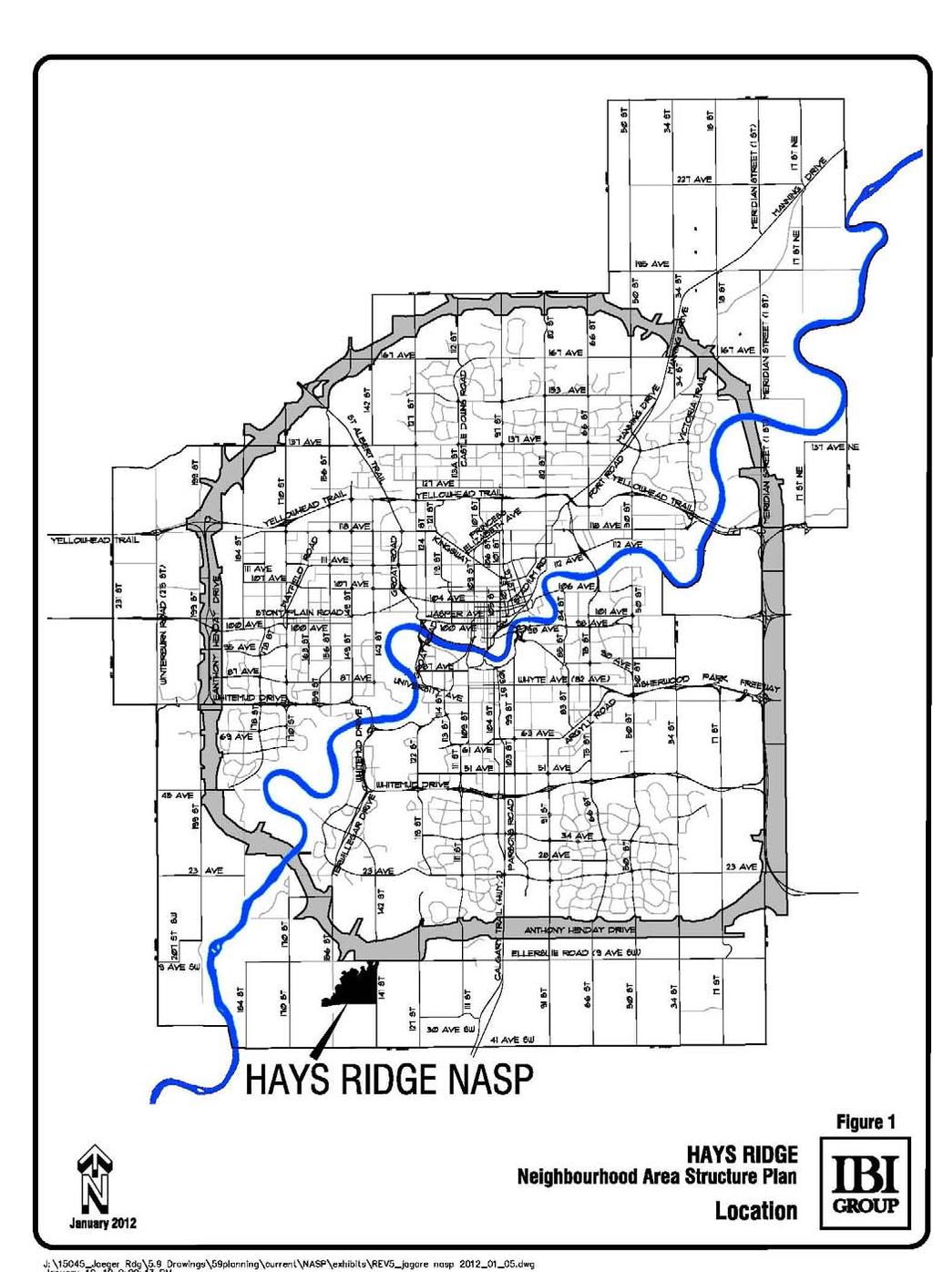
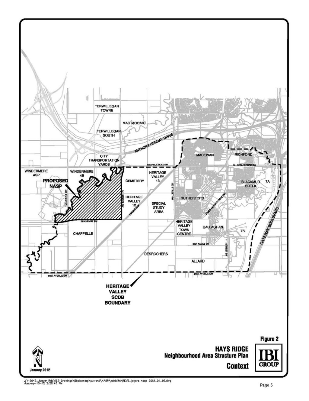
8 2.0 PLAN CONTEXT 2.1 Location The Hays Ridge NASP is located in southwest Edmonton, and is comprised of lands largely located within Section and the NE ¼ The total gross area is approximately 195 hectares (ha) and is defined by the following boundaries (see Figure 1 Location): Northern Boundary North Saskatchewan River Valley and Ravine System (Whitemud Creek) and Ellerslie Road Western Boundary North Saskatchewan River Valley and Ravine System (Whitemud Creek) Eastern Boundary 141 Street SW Southern Boundary Future alignment of 28 Avenue SW The subject lands are identified as Neighbourhood 11 in the Heritage Valley SCDB. Currently, the lands are accessed from Ellerslie Road SW and 141 Street SW. As shown in Figure 2 Context, the Chappelle neighbourhood is located to the south across 28 Avenue SW. Glenridding Ravine neighbourhood is located to the west across the Whitemud Creek Ravine. The City owned Ambleside Integrated Service Site is located north across Ellerslie Road. A portion of the Transportation Utility Corridor (TUC) is located to the north-east of the Plan area. The Rosehill Cemetery and Heritage Valley 12 neighbourhood are currently located directly east across 141 Street SW. 2.2 Background The Hays Ridge NASP was prepared in response to anticipated market demands in the capital region. Further information regarding land ownership and site context is outlined in Table 1 Land Ownership and Figure 3 Land Ownership. The preparation of this NASP was guided by existing City of Edmonton statutory plans and policies including the Capital Region Growth Plan, The Way We Grow, The Way We Move, the Heritage Valley Servicing Concept Design Brief (SCDB), the Suburban Neighbourhood Design Principles (SNDP), the Urban Parks Management Plan (UPMP) and the Terms of Reference for the Preparation and Amendment of Residential Neighbourhood Structure Plans. Conformance to these plans and policies are discussed in Appendix Land Ownership The Hays Ridge NASP was prepared on behalf of a private developer who owns approximately hectares (64%) of the land within the Plan area. The remaining lands are held by a number of non-participating landowners. Land ownership is described in Table 1 below and shown in Figure 3 Land Ownership. 3
9 4
10 5
11 6
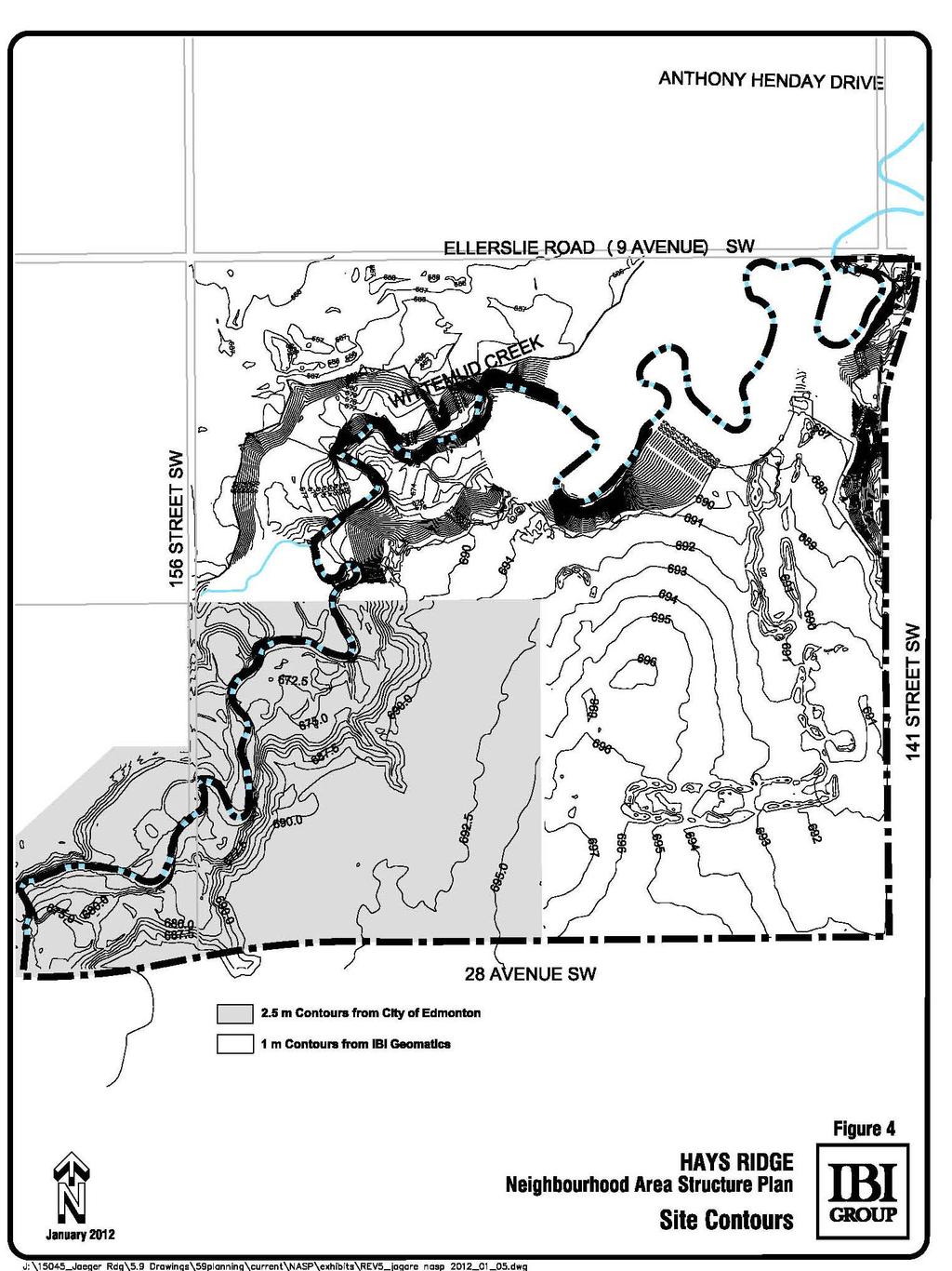
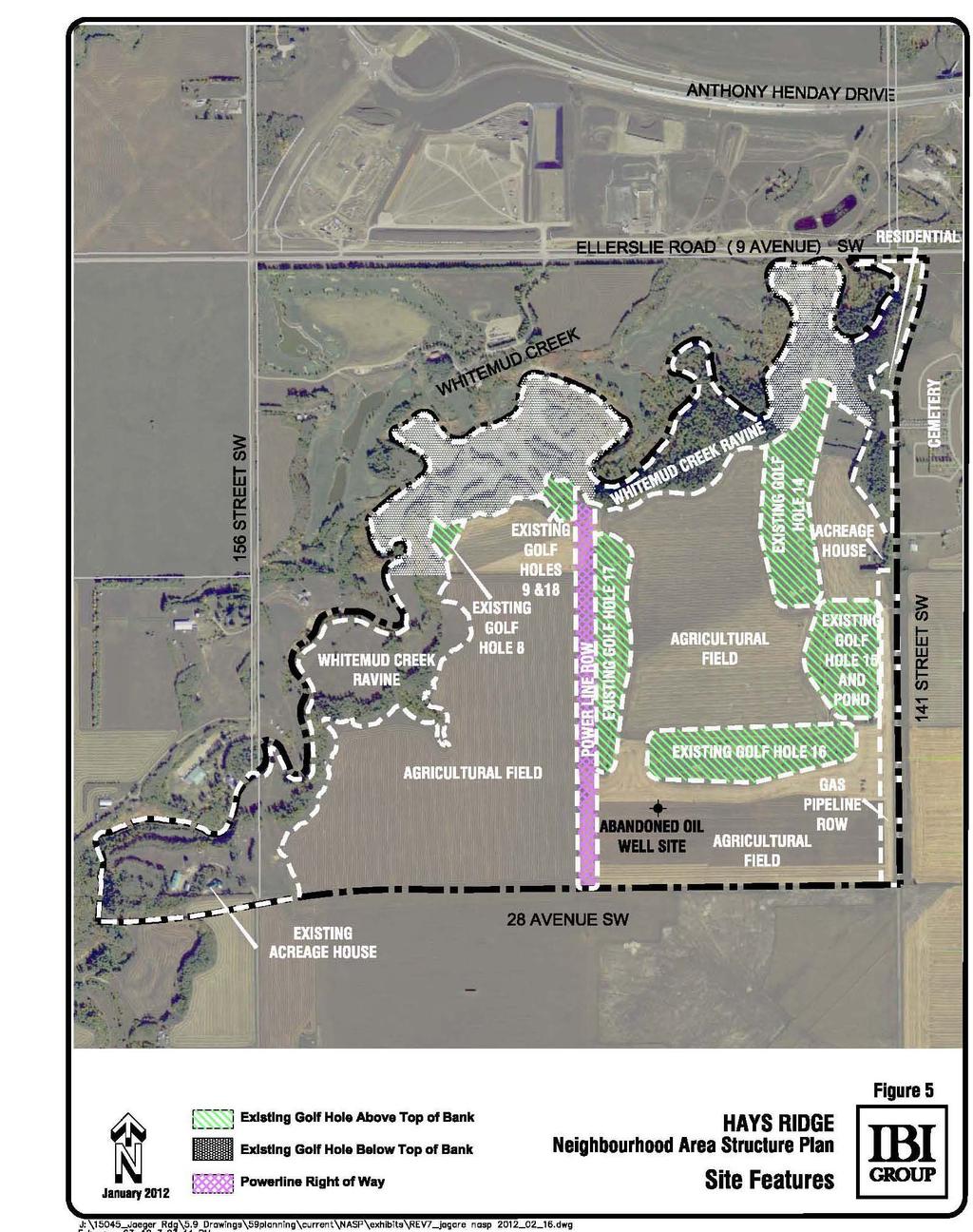
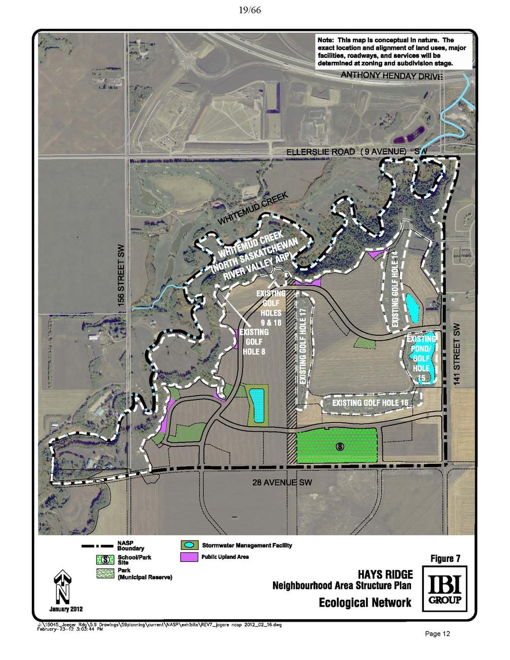
12 Table 1: Land Ownership Titled Owner Legal Description Area (ha) in NASP 1 Private Corporate Owner (participating) 4; 25; 51; 23; NW Private Owner (non-participating) 4; 25; 51; 23; SW Private Corporate Owner (participating) 4; 25; 51; 23; SE Private Corporate Owner (participating) 4; 25; 51; 23; NE Private Owner (non-participating) ; E Private Owner (non-participating) 4; 25; 51; 15; N ½ of NE Private Corporate Owner (participating) 4; 25; 51; 23; NW Private Corporate Owner (non-participating) 4;25;51;24; NW Government Road Allowance N/A Private Corporate Owner (non-participating) 4;25;51;14; NW 0.4 TOTAL Site Context TOPOGRAPHY The plan area is generally flat, sloping down towards Whitemud Creek Ravine running along the northwest boundary of the neighbourhood. Local variations in topography across the Plan area are shown in Figure 4 Site Contours. Topography and natural drainage patterns will have some implications for design of the engineering services for this neighbourhood SOILS The existing soils within the Plan area consist of moist organic black topsoil, made up of silt, sand and clay to a depth of 0.3 to 0.9 m. Below the surficial soil strata is a layer of stiff silty clay to a depth of approximately 8.3 m. Canada Land Inventory describes to the developable upland area above the top of bank as Class 1. Class 1 soils have no significant limitations in use for crops. Lands below the top of bank and associated with the Whitemud Creek Ravine fall within Class 6. Class 6 soils are capable only of producing perennial forage crops, and improvement practices are feasible but severely limited by steep slopes and valley lands NATURAL AREAS AND ECOLOGICAL CONNECTIVITY Figure 5 - Site Features shows that the subject lands currently contains four (4) complete and three (3) partial golf holes, and primarily agricultural land uses above the top-of-bank. The remaining fourteen (14) golf holes of the Jagare Ridge Golf Club are located within the boundaries of the Whitemud Creek Ravine and exterior to the Plan area on the uplands to the north of the Whitemud Creek Ravine. There are several treed areas in the northeast corner of the plan area and to the west along the top-of-bank. A utility company s power line right-of-way bisects the plan area in a north-south orientation. The Plan area also includes the south side of the Whitemud Creek Ravine with the creek delineating the neighbourhood boundary. No natural areas were found above the top-of-bank as defined in Inventory of Environmentally Sensitive and Significant Natural Areas (Geowest, 1993); Edmonton State of Natural Areas Report (Spencer, 2005); 2007 Natural Areas Loss Assessment (Golder, 2008); and 2008 Natural Areas Loss Assessment (Golder, 2009). Amended by Editor 7
13 8
14 9
15 An investigation of slope stability and determination of setback investigation was completed in September 2008 and is submitted under separate cover. This report assesses groundwater and soil conditions and makes recommendations for construction activities near the top-of-bank. Development setback distances from the top-of-bank are shown on Figure 6 Top-of-Bank. A top-of-bank walk was completed with City administration and participating landowners in October 2010 to determine an agreed upon alignment of the top-of-bank line. A top-of-bank walk has not been completed for lands owned by non-participating landowners. Ecological features within the Plan area are shown on Figure 7 Ecological Network WETLANDS No wetlands were identified in the Hays Ridge NASP area as defined in Inventory of Environmentally Sensitive and Significant Natural Areas (Geowest, 1993); Edmonton State of Natural Areas Report (Spencer, 2005); 2007 Natural Areas Loss Assessment (Golder, 2008); and 2008 Natural Areas Loss Assessment (Golder, 2009) EXISTING LAND USES The Hays Ridge NASP is part of the Heritage Valley Servicing Concept Design Brief area which contains several existing and developing residential neighbourhoods. These neighbourhoods contain established commercial areas and future school sites that are currently in development. At present access to the Plan area is restricted to 141 Street SW along the east boundary of the Plan area which connects to Ellerslie Road (9 Avenue) SW to the north with connections to the Anthony Henday. The Whitemud Creek Ravine presents a physical barrier with future access to the west via planned development of 28 Avenue SW along the south edge of the Plan area west of 141 Street SW. There is an existing house in the northeast of the neighbourhood accessed off 141 Street SW. Another house and acreage development is located in the southwest and accessed off 156 Street SW ENVIRONMENTAL ASSESSMENTS A Phase 1 Environmental Site Assessment (ESA) was completed and is submitted under separate cover. Figure 8 Environmental Site Assessment Area shows where ESAs have been completed within the neighbourhood. The ESA concluded that there are no environmental concerns and that no further study is required for the areas in the study. A Phase II ESA was conducted for the well site area. The study found no contamination of the land surrounding the reclaimed well site. A Well Site Risk Assessment was completed for the well site in March This study found the well site to be minimal risk to any surrounding uses. The Risk Assessment has been submitted under separate cover. 10
16 11
17 12
 Amended by Editor")
18 PHASE 1 ESA BY PRIVATE CORPORATION (NOVEMBER 2006 UPDATED JANUARY 2010) Amended by Editor 13
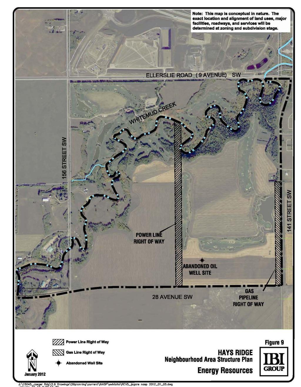
19 2.4.7 HISTORICAL RESOURCES An Archaeological and Heritage Resource Analysis (HRA) was completed by Stantec and is submitted under separate cover confirming that the area has no archaeological or heritage significance. The HRA study has received a clearance letter from the Province of Alberta, which is also submitted to the City with this NASP. Non-participating lands will require a HRA if they are to be developed PIPELINES AND OIL WELL SITES Table 2 is a summary of the pipeline and oil well information found on the Abadata website. Locations of the wells and pipelines are shown on Figure 9 Energy Resources. A private Corporate owner s well site has been abandoned and reclamation certificate was issued in Table 2 Energy Resource Summary (Amended by Editor) Well ID/License No. 00/ W4/ Title Registration # 6892RJ Titled Owner Substance Status Reclamation A private corporate owner Oil Abandoned November 15, 1949 Certificate issued March 1967 A utility company Gas Operating N/A A utility company s right-of-way along the west side of 141 Street SW (Figure 9 Energy Resources) currently services a house located within the southeast corner of the NE¼ Section W4M. This gas line will be abandoned and the easement discharged once the house is vacated prior to development of the area. Along the west edge of the east half of Section W4M is a utility company s right-of-way (Figure 9 Energy Resources) which is to be retained and incorporated into the development concept for the Plan area. Amended by Editor Amended by Editor GOLF COURSE LANDS Of the gross hectares that form the plan area, 21.7 hectares form golf holes 8, 9, 14, 15, 16, 17, and 18 of the Jagare Ridge Golf Club. Future development opportunities of the table land portion of the golf course exist if the golf course ceases to operate. Should these golf course lands be developed, an NASP Amendment would be required. No assumptions should be made that the City would take over these golf course lands and maintain them as park should the golf course cease operations. Should the golf course cease operations as a golf course, the golf course lands below top-of-bank would be subject to dedication as Environmental Reserve in accordance with relevant City policies at time of development and the golf course lands above the top-of-bank shall owe deferred reserves. 14
20 15
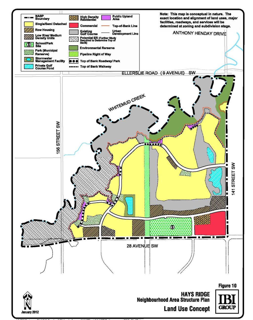
21 2.5 Public Involvement Consistent with Policy C513 City of Edmonton Public Involvement Policy, advance notification was sent to surrounding property owners and affected Community Leagues on March 11, 2010 advising them of the application and encouraging them to contact either the Sustainable Development Department or the applicant (IBI Group) to communicate any possible concerns. As part of the planning process, a public meeting was held by the City of Edmonton s Sustainable Development Department on April 28, 2011 at the Ellerslie Rugby Park. Mailed notification letters were sent to landowners and affected Community Leagues in proximity to the NASP area advising of this meeting. Notice of the meeting was also advertised in the Edmonton Examiner on April 20, 2011 and on the City of Edmonton Website on April 21, At the meeting residents had an opportunity to review and comment on the draft NASP. Landowners and affected Community Leagues in the area have also been notified of the Public Hearing and requested to provide either written or verbal comments to Council. 3.0 LAND USE, TRANSPORTATION & SERVICING 3.1 Land Use Concept & Population Statistics The following sections outline the land use concept, plan goals, and objectives for the Hays Ridge NASP. The development concept as illustrated in Figure 10 Land Use Concept, is established in conformance with applicable statutory requirements, City-level strategic policies, guidelines and procedures. The land use concept incorporates the Development Objectives and Principles outlined in the following sections for an attractive community with direct pedestrian and vehicle linkages to local amenities. The NASP is aligned with technical studies and recommendations such as a Neighbourhood Design Report, a Transportation Impact Assessment, an Ecological Design Report, Geotechnical Studies, Environmental Studies and others. The Hays Ridge neighbourhood is primarily residential, with an emphasis on the incorporation of the Whitemud Creek Ravine, as well as a portion of the existing Jagare Ridge Golf Club as key focal points. The NASP also includes provisions for commercial retail uses, a school, park spaces, and stormwater management facilities. The plan promotes a diversity of housing types; pedestrian connectivity to local amenities such as the Whitemud Creek Ravine; and accessibility to major municipal and regional transportation corridors. A statistical summary of the proposed land uses is provided in Table 3 Proposed Land Use Concept and Population Statistics. 3.2 Vision The Hays Ridge NASP describes a neighbourhood that is accessible, walkable, and attractive with a mix of residential densities to attract varying lifestyles, and age groups. The community identity is based upon neighbourhood focal points including the top-of-bank walkway adjacent to the Whitemud Creek Ravine, the integration of the Jagare Ridge Golf Club, and the retail opportunities of the commercial site at the southeast entrance to the neighbourhood. 16
22 17
23 HAYS RIDGE NASP TABLE 3 PROPOSED LAND USE CONCEPT AND POPULATION STATISTICS Area (ha) % of GA % of GDA GROSS AREA % Environmental Reserve % Potential ER (To be confirmed by studies) % Golf Course below Top-of-Bank % Lands between Top-of-Bank and Urban Development Line % Lands between Urban Development Line and Top-of-Bank Roadway % Utility R/W % Arterial Road R/W % GROSS DEVELOPABLE AREA % Golf Holes # 8, 9, 14, 15, 16, 17, 18 (including Private Ponds) % Parkland, Recreation, School (Municipal Reserve) 1 School/Park Site % Pocket Parks % Community Commercial % Transportation Circulation % Infrastructure/Servicing Stormwater Management Facilities (Public) % TOTAL Non-Residential Area % Net Residential Area (NRA) % 8.8% RESIDENTIAL LAND USE, DWELLING UNIT COUNT AND POPULATION Area(ha) Units/ha Units % of Total People/Unit Population % of NRA Low Density Residential (LDR) Single/Semi-Detached , % % Medium Density Residential (MDR) Row Housing % % Low-Rise/Medium Density Units % % High Density Residential (HDR) Medium to High Rise Units % % Total Residential ,199 5, % SUSTAINABILITY MEASURES Population Density (ppnrha) 84.3 Unit Density (upnrha) 35.3 [Single/Semi-Detached] / [Row Housing; Low-Rise/Medium Density Units; Medium to High Rise Units] Units Ratio 56.5% // 43.5% Population (%) within 500m of Parkland 100% Population (%) within 400m of Transit Service 100% Population (%) within 600m of Commercial Service 50% Presence/Loss of Natural Area Features Land Water Protected as Environmental Reserve (ha) Conserved as Naturalized Municipal Reserve (ha) n/a n/a Protected through other means (ha) n/a n/a Lost to Development n/a n/a STUDENT GENERATION Public School Board 437 Elementary 236 Junior High 118 Senior High 118 Separate School Board 236 Elementary 118 Junior High 59 Senior High 59 Total Student Population Areas dedicated to Municipal Reserves to be confirmed by legal survey 2 includes all collector roadways, local roadways, lanes, and walkway/road right-of-ways 18
24 3.3 Goals & Objectives The Hays Ridge NASP was prepared in accordance with the policies and principles identified in the Capital Region Growth Plan, The Way We Grow, The Way We Move, the Heritage Valley Servicing Concept Design Brief (SCDB) and other relevant municipal policy and statutory documents. The overall goals include: to foster a sense of community and connectedness by creating a neighbourhood with an identifiable sense of place; to establish a high standard for environmental stewardship creating a community that enjoys and shares the natural environment; to create a neighbourhood that embraces its natural features and integrates them within the neighbourhood; to create a common identity for the neighbourhood through the establishment of an identifiable sense of place; to establish a neighbourhood sense of safety and belonging that encourages participation and involvement in the community. to provide opportunities for people of different lifestyles and backgrounds to thrive in the neighbourhood environment throughout the stages of life. The following Plan objectives were developed to assist in achieving the above noted goals. GREEN DEVELOPMENT 1. Consider sustainable development principles in the planning and design of the neighbourhood. 2. Encourage naturalized landscaping on public and private lands to maximize environmental benefit. URBAN DESIGN 1. Design residential streets that are pedestrian friendly, promote safe travel and are an integral and attractive component of the neighbourhood. 2. Ensure the integration of the existing Jagare Ridge Golf Club as a scenic vista within the neighbourhood. 3. Provide opportunities for views and vistas to Whitemud Creek Ravine and the existing Jagare Ridge Golf Club. 4. Create a sense of surveillance and occupancy where public and private space interface. 5. Ensure that redevelopment of the existing golf holes above the top-of-bank integrate with and connect to surrounding land uses, if the golf course ceases to exist. ECOLOGY 1. Protect the Whitemud Creek Ravine from rural residential development. 19
25 ENVIRONMENT 1. Ensure that the environmental status of lands in the Hays Ridge Neighbourhood are suitable to development and the Environmental Site Assessments (ESAs) are complete and up-to-date at the time of rezoning. 2. Ensure that urban development around the abandoned well site adheres to the policy requirements of the Energy Resource Conservation Board (ERCB) and the City of Edmonton at time of development. 3. Ensure the ongoing operation and integrity of existing pipeline and utility infrastructure. HISTORICAL RESOURCES 1. Identify and protect items with historical significance in the Hays Ridge neighbourhood. RESIDENTIAL 1. Provide a variety of housing types that serve a range of age groups, income levels and lifestyle needs. 2. Locate higher density residential development with good access to, and in support of, public transit facilities. 3. Establish residential densities that meet the density target set out by the Capital Region Growth Plan. PARKLAND, RECREATION FACILITIES & SCHOOLS 1. Provide school/park sites that are accessible and are serviced to the anticipated program requirements. 2. Provide active and passive recreational opportunities through a connected system of public open spaces and pocket parks. COMMERCIAL 1. Provide convenient access to commercial uses for pedestrians and vehicles from Hays Ridge and surrounding neighbourhoods. 2. Provide human-scale retail commercial with opportunities for office uses. TRANSPORTATION 1. Provide connections from focal points and amenities to residential areas. 2. Mitigate the impact of vehicular traffic associated with medium and high density development on low density residential areas. 3. Minimize traffic congestion and enhance safety on the internal collector roadway. 4. Provide noise attenuation where residential development backs onto arterial roads. 20
26 5. Provide a collector roadway system that allows efficient movement of vehicular traffic through the neighbourhood and discourages shortcutting on local roadways. 6. Provide views and connections to the top-of-bank via top-of-bank road and walkway connections. PEDESTRIAN AND BICYCLE CIRCULATION 1. Promote alternate modes of transportation within the transportation network and minimize walking distances to focal points. 2. Provide public access to Whitemud Creek Ravine. 3. Design a system of walkways that provides a feeling of safety for users. 4. Incorporate walkway connections into the street system. 5. Provide at grade golf cart/golfer crossings to access golf course fairways. TRANSIT 1. Provide convenient public transit opportunities for residents. 2. Provide public transit in accordance with City of Edmonton Transit System Guidelines and based on local demand. 3. Provide access to transit services at key focal points. JAGARE RIDGE GOLF CLUB 1. Integrate the existing Jagare Ridge Golf Club within the Environmental Reserve areas below top-of-bank. 2. Integrate the golf holes that lie above the top-of-bank with the surrounding residential uses. 3. Ensure dedication of Whitemud Creek Ravine as Environmental Reserve below the topof-bank if the golf course should ever cease to operate and exist. 4. Maintain private ownership and operation of the Jagare Ridge Golf Club until such time as it ceases to operate. 5. Ensure golf holes above top-of-bank can be redesignated to residential or open space uses and integrated with surrounding uses if the golf course ceases to exist. INFRASTRUCTURE, SERVICING & STAGING 1. Ensure the neighbourhood is serviced to a full urban standard, in an efficient, contiguous and staged manner. 21
27 3.4 Policy GREEN DEVELOPMENT Objective NASP Policy Implementation Consider sustainable development principles in the planning and design of the neighbourhood The Hays Ridge NASP shall allow for opportunities to use and promote environmentally friendly technologies in construction and design of the neighbourhood Green development design guidelines shall be explored through consultation with City administration at subdivision design. Rationale: Green development shall be promoted through the use of efficient and environmentally friendly technologies, products and practices. Green development should be guided by principles from Leadership in Energy and Environmental Design (LEED) Neighbourhood Design and Built Green policy programs Encourage naturalized landscaping on public and private lands to maximize environmental benefit Landscaping shall incorporate the use of native plant species within all public open spaces Specific plant species will be determined by the developer and the City as part of engineering drawing review. Rationale: Planting native species promotes a healthier natural ecosystem that will over time integrate with the existing natural areas of the neighbourhood and ravine. Planting of native species helps to prevent invasive non-native species from taking over. TECHNICAL SUMMARY: No specific technical requirements were identified URBAN DESIGN Objective NASP Policy Implementation Streetscape design should consider variety in building forms and massing options to create a visually interesting pedestrian experience with elements that promote safety Design residential streets that are pedestrian friendly, promote safe travel and are an integral and attractive component of the neighbourhood Consideration for these elements will be evaluated at the subdivision design and development permit stage. Rationale: Designing attractive streetscapes and providing convenient pedestrian linkages to neighbourhood focal points helps to create a user friendly pedestrian network. Orientation of buildings towards public areas is an important contributing factor to promoting safety through passive surveillance. (CPTED principle) Ensure integration of the existing Jagare Ridge Golf Club as a scenic vista within the neighbourhood (i) The neighbourhood shall be designed to integrate the existing golf holes of Jagare Ridge Golf Club that lie above the top-of-bank adjacent to residential development (i) The locations of the golf holes are identified in Figure 10 Land Use Concept and shall maintain physical separation from residential uses through fencing and/or landscape treatments. Residential streets should be designed to orient lots backing onto golf holes and to 22
28 Objective NASP Policy Implementation provide several opportunities for public viewpoints (ii) Where practical and feasible, trails that interconnect to, cross, or are adjacent to the privately owned Jagare Ridge Golf Club shall be developed in cooperation with adjacent residential areas fostering safety through provision of appropriate fencing and road crossings (iii) Where golf carts and golfers utilize public lands for the purpose of access to the Jagare Ridge Golf Club, crossings shall be designed with signage to help maintain separation of pedestrians from golf cart (ii) Signage and other features to delineate golf course from public lands should be considered and installed at time of residential development of each stage (iii) The locations of golf cart crossings of the public roadway are shown on Figure 11 Pedestrian and Shared Use Paths, and will be designed at time of subdivision. traffic. Rationale: Proper integration of the existing Jagare Ridge Golf Club lands into residential development will achieve an attractive neighbourhood design with a desirable visual amenity. Signage shall be used to ensure there is no confusion on where public and private spaces exist Provide opportunities for views and vistas to Whitemud Creek Ravine and the existing Jagare Ridge Golf Club Buildings adjacent to the ravine should be oriented to provide views of the ravine for residents and viewpoint opportunities shall be provided along the topof-bank roadways and the topof-bank walkway Viewpoints and vista opportunities shall be provided through application of the City of Edmonton Top-of-Bank policy C542. Rationale: Hays Ridge is a neighbourhood planned to take advantage of its existing picturesque surroundings, such as the Whitemud Creek Ravine and the Jagare Ridge Golf Club. Through highlighting these features, the Plan creates a unique identity for the neighbourhood that visitors and residents can identify with Create a sense of surveillance and occupancy where public and private space interface (i) Walkways and parks should be visible, well-lit, and located where residential development can provide passive surveillance (ii) Buildings that front onto the street or other public areas should include features (doors, windows, and landscaped yards) that create opportunities for surveillance and a sense of occupancy wherever there is an interface with the street or a (i) Figure 10 Land Use Concept identifies parks and ponds with frontage onto public streets and in close proximity to residential uses (ii) Building design shall be considered at the subdivision and development permit stage in accordance with the Zoning Bylaw. 23
29 Objective NASP Policy Implementation public space. Rationale: Development will be planned with consideration given to up-to-date technologies, cutting edge design and principles that provide an environment promoting safety and convenience Ensure that redevelopment of the existing golf holes above the top-of-bank integrate with and connect to surrounding land uses, if the golf course ceases to exist If the golf course ceases to operate in the future, the lands above top-of-bank shall be redeveloped as residential uses or shall be transferred to the City as public open space with the appropriate connections to surrounding land uses The golf course lands located above the top-of-bank will require an amendment to the NASP prior to redevelopment to residential or public open space uses. As shown in Figure 11 Pedestrian Network & Shared Use Paths, Golf Holes 14, 15 and 17 will have access to the collector road in the neighbourhood. In order to facilitate the potential redevelopment of Golf Hole 16, the subdivision design should incorporate an access easement to the south east, and if required, to the south west to the collector road. The walkway with public access easement to the south of Golf Hole 17 and west of Golf Hole 16 may be upgraded to an emergency access in order to provide two accesses to these sites. Rationale: Options for redevelopment of the golf course lands shall be explored under an NASP amendment if the Jagare Ridge Golf Club ceases operations. TECHNICAL SUMMARY: No specific technical requirements are identified. 24

30 IBI GROUP 25
31 3.4.3 ECOLOGY Objective NASP Policy Implementation Protect the Whitemud Creek Ravine from rural residential development Lands below the top-of-bank that are not in use by the golf course shall be dedicated as Environmental Reserve Environmental Reserve lands will be dedicated through subdivision in accordance with the Municipal Government Act Lands identified as potential Environmental Reserve (further study required) in Figure 10 Land Use Concept are owned by non-participating landowners and shall require geotechnical assessment, slope stability analysis, top-ofbank walk and an amendment to the Hays Ridge NASP at the time of an application for development to determine final Environmental Reserve Delineation Environmental Impact Assessments shall be completed for stormwater outfalls A buffer shall be provided between the top-of-bank and residential development If the golf course ceases to operate, the land below top-ofbank shall be dedicated as Environmental Reserve Top-of-bank in non-participating lands shall be determined through geotechnical study slope stability analysis and topof-bank walk at time of application for development of those lands Environmental Impact Assessments shall be submitted to the City at the Development Permit stage A minimum 10 m wide setback shall be provided as a buffer from the top-of-bank and generally contains the top-ofbank walkway as shown in Figure 10 Land Use Concept. This setback varies from minimum 10 m setback required in the TOB policy C542 to minimum 13 m setback as determined by geotechnical study The Deferred Reserve Dedication Agreement has been created to delineate the current golf course lands from the environmental reserve. Rationale: This NASP plans to highlight the ecological elements of the site by providing convenient accesses and/or views to these features. The Hays Ridge NASP follows the City of Edmonton Topof-Bank policy C542. The Deferred Reserve Dedication Agreement in place outlines lands required 26
32 Objective NASP Policy Implementation for Environmental Reserve and describes the future process to allow dedication of golf course lands to Environmental Reserve. TECHNICAL SUMMARY: An Ecological Design report was completed by Bruce Thompson & Associates Inc. The findings and recommendations of this report were considered when planning the Hays Ridge NASP. The report found that the subject lands were generally flat with few trees. The major ecological feature of the lands is the Whitemud Creek Ravine that runs along the northwest boundary of the Plan area as shown in Figure 9 Ecological Network. A geotechnical study was prepared by C. T. Associates and was used in conjunction with a top-ofbank walk to determine the top-of-bank and development setbacks ENVIRONMENT Objective NASP Policy Implementation Environmental Conditions of the site shall be confirmed through submission of Environmental Site Assessment (ESA) Reports and/or updates Ensure that the environmental status of lands in the Hays Ridge neighbourhood are suitable for development and the Environmental Site Assessments (ESA) are complete and up-to-date at the time of rezoning. Where necessary, contaminated material shall be removed and disposed of in an environmentally sensitive manner, in accordance with Federal, Provincial and Municipal regulations ESA reports and any updates shall receive sign-off by City Administration prior to the rezoning stage of development. Site remediation, where necessary, shall be completed prior to rezoning. An environmental site assessment report verifying the remediation shall be submitted for approval by City administration prior to rezoning of subject lands. Rationale: A phase one ESA report and update for participating landowners was submitted to the City and approved as part of this application for NASP, as shown on Figure 8 Environmental Site Assessment Area. Environmental conditions were cleared and will be monitored throughout the zoning of lands, in accordance to City policy Ensure that urban development around the abandoned well site adheres to the policy requirements of the Energy Resource Conservation Board (ERCB) and the City of Edmonton at time of development Development shall adhere to the requirements of the ERCB and City of Edmonton Policy C515 and future policies for Oil and Gas facilities and abandoned well sites The abandoned well site shall be located within a setback and incorporated into the adjacent road right-of-way. Details regarding the setback area will be reviewed with subdivision and will be to the satisfaction of the City of Edmonton. Additional road right-of-way may be necessary to accommodate the well site. Rationale: A well site risk assessment was submitted to the City for an analysis of potential risks associated with the abandoned well. This study reported minimal future risk associated with the well site. 27
33 Policies relating to existing and abandoned oil and gas wells will ensure conscientious residential development around oil and gas well sites and pipelines at all stages of the plan implementation and construction process, while minimizing potential disturbances to the area s future residents. Urban development in the vicinity of all resource well sites will be planned in accordance with current City policy C515 Oil and Gas Facilities (2007) and future policies and other relevant City procedures. Development of lands involving abandoned wells will comply with ERCB guidelines for development around abandoned wells Ensure the ongoing operation and integrity of existing pipeline and utility infrastructure Hays Ridge NASP shall maintain the power line right-ofway for continued operation of the utilities within An existing gas pipeline shall be decommissioned with demolition of the existing house The power line right-of-way and Gas pipeline right-of-way are shown on Figure 9 Energy Resources and shall remain unless removed from the land titles The gas pipeline shall be decommissioned at such a time as the existing house is removed from the property. Rationale: Right-of-ways for utility infrastructure are included on land titles. The right-of-way maintains the legal right for these facilities to operate. TECHNICAL SUMMARY: A Phase 1 Environmental Site Assessment and report update were completed for the participating lands. These reports were submitted under separate cover. The study concluded that there is no need for further testing or investigation of the site for environmental contaminants or concerns HISTORICAL RESOURCES Objective NASP Policy Implementation Identify and protect items with historical significance in the Hays Ridge neighbourhood The NASP shall consider the recommendations and findings of the Historical Resource Overview (HRO) A Historical Resource Overview and a clearance letter from the Province of Alberta were submitted with this NASP report under separate cover for participating land owners. Rationale: The HRO found no evidence of significant historical resources within these lands. TECHNICAL SUMMARY: A Historical Resource Overview report was submitted under separate cover for participating land owners. A review of the report by the Province identified no need for further study. The City review of the report identified the potential for future interpretive signage within the Environmental Reserve to identify mining history in the area. 28
34 3.4.6 RESIDENTIAL Objective NASP Policy Implementation This NASP shall provide A variety of housing types and different types of housing, densities are shown in Figure including ground oriented 10 - Land Use Concept. (single-detached, semidetached, Specific housing types to be and town housing) constructed shall be and non-ground oriented (lowrise determined at zoning and apartments, medium-rise, subdivision. and high-rise) housing Provide a variety of housing types that serve a range of age groups, income levels and lifestyle needs. Rationale: Through the provision of different types and affordability of housing, this NASP will help provide access to public amenities and housing for a variety of age groups, income levels and lifestyle preferences. A semi-circle shaped parcel of land is identified as low density residential in the northeast portion of the Plan. This site shall accommodate low density residential with a separate entrance to 141 Street. A top-of-bank has been established for the site through a walk with City administration confirming the boundaries of the site Locate higher density residential development with good access to, and in support of, public transit facilities High residential density should be developed near entrances to the neighbourhood, along collector roads and in proximity to the transit and arterial systems Figure 10 - Land Use Concept illustrates locations of medium and high density residential units along collector roads. Rationale: Through locating higher density sites near entrances to Hays Ridge and along collector roads, traffic volume is concentrated on collectors, providing efficient movement of vehicles in and out of the neighbourhood. Transit routes are located on collector roads providing convenient access to transit for the largest number of people. A high density residential development is planned next to the commercial site in the south east corner of the neighbourhood next to the 28 Avenue SW entrance. This site has the potential to accommodate high-density apartment housing, including lifestyle housing or senior s housing with assisted living facilities. This location would take advantage of accessible transit facilities and convenient access to the commercial site Establish residential densities that meet the density target set out by the Capital Region Growth Plan The neighbourhood shall provide residential densities consistent with the priority Growth Area Cw defined as 30 to 40 units per net residential hectare in the Capital Region Growth Plan The density defined in Table 3 - Proposed Land Use Concept and Population Statistics is about 35 units per net residential hectare. Rationale: Hays Ridge shall have a mix of residential densities including single detached, semidetached town house and apartment style housing forms. TECHNICAL SUMMARY: No specific technical requirements were further identified. 29
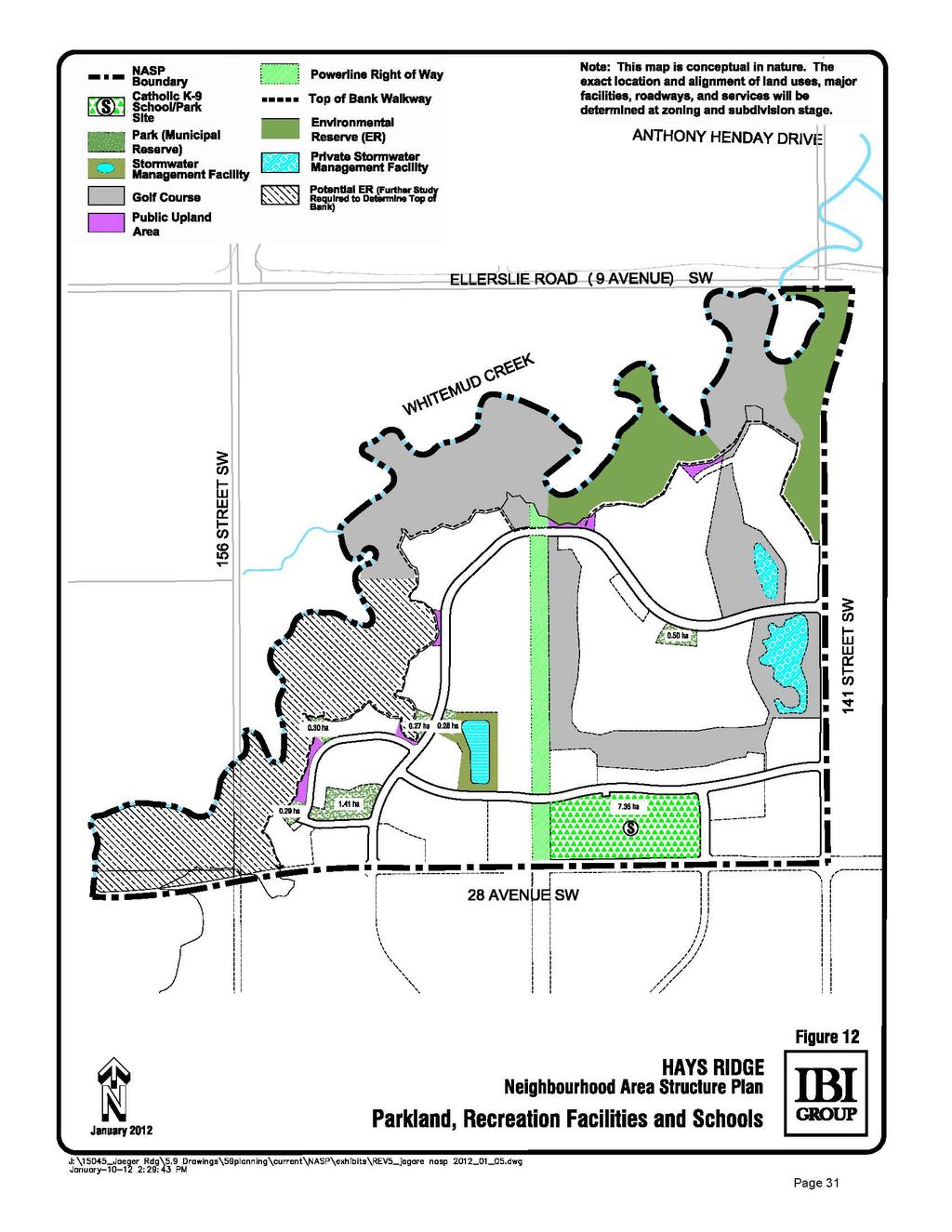
35 3.4.7 PARKLAND, RECREATION FACILITIES & SCHOOLS Objective NASP Policy Implementation The Catholic (kindergarten to Grade 9) school shall be located near the entrance to the neighbourhood with access to the collector road, walkway and transit facilities Provide school/park sites that are accessible and are serviced to the anticipated program requirements. Parks are to be serviced to City standards The school site is located near the south entrance from 28 Avenue SW as shown on Figure 12 Parkland, Recreational Facilities and Schools. The anticipated transit route is shown on Figure 13 Transportation Network. The provision of utility services for park sites shall conform to relevant City standards at the time of subdivision and development. Rationale: Located near the neighbourhood entrance, the school site is accessible to students from surrounding neighbourhoods that are part of the catchment area. The school site shall be accessible from walkways, roads and transit facilities and its location prevents the creation of extra traffic on local roads internal to the neighbourhood. Utilities shall be provided as required through engineering design and servicing agreement in accordance with relevant City standards Provide active and passive recreational opportunities through a connected system of public open spaces and pocket parks (i) Park spaces shall be designed to accommodate both active and passive recreational opportunities. Pocket parks should be dispersed throughout the neighbourhood, providing opportunities for both active and passive recreation and the design should follow basic CPTED principles (ii) Public Upland areas shall be dedicated as road right-of-way where undevelopable lands exist between the Urban Development Line and top-of-bank roadway The location of the park sites are shown on Figure 12- Parkland, Recreational Facilities and Schools and will be dedicated as municipal reserve at time of subdivision (ii) The location of public upland areas are shown in Figure 12 Parkland, Recreational Facilities and Schools. Rationale: The pocket parks and public open spaces will be accessible to residents of the neighbourhood who seek active and passive recreational activities. The school site and parks within Hays Ridge shall be dedicated based on 10% Municipal Reserve requirements of the Municipal Government Act. Public Upland Areas are residual parcels of land between the roadway and the Urban Development Line. These areas will be incorporated and maintained as part of the adjoining space (Environmental Reserve). An agreement between the City of Edmonton and the current Land Owners and their successors 30
36 Objective NASP Policy Implementation shall be registered on title by caveat. This agreement stipulates the future allocation of both Environmental and Municipal Reserves. Municipal Reserve (MR) will be deferred by this agreement, to the Golf Course Parcel created by subdivision in the amount of 10% of the area of the Gross Developable Area (GDA), less the land area identified to be dedicated as School/Park Site and the Pocket Park. According to the Neighbourhood Area Structure Plan, a 7.35 ha area is required for the School/Park Site and a 0.5 ha is required as Pocket Park within the titled area which also contains the Jagare Ridge Golf Club. The City and Developer have agreed that the golf club lands located above top-of-bank shall dedicate a sufficient amount of MR as land to ensure the planned MR land requirements are achieved. The remainder of the MR requirements will be secured by the City in accordance with the agreement registered by caveat. TECHNICAL SUMMARY: A Parkland Impact Assessment and a Community Knowledge Campus Report were submitted under separate cover with this NASP report COMMERCIAL Objective NASP Policy Implementation (i) The commercial site shall be located near the access to arterial roads maximizing visibility and access potential Provide convenient access to commercial uses for pedestrians and vehicles from Hays Ridge and surrounding neighbourhoods (ii) Designated pedestrian walkways shall be provided from residential areas to commercial sites Figure 10 Land Use Concept identifies the location of the commercial site near the south east entrance from 28 Avenue SW. Access locations must be reviewed and approved by Transportation Services at time of subdivision or Development Permit Application. Rationale: A commercial site is planned in the southeast corner of the neighbourhood. Access shall be permitted to the site from all four surrounding public roadways. Pedestrian access to the site shall be accommodated through designated walkways connected to the neighbourhood pedestrian circulation system Provide human-scale commercial uses with opportunities for office uses (i) Commercial retail uses shall be ground-oriented with access at street level (ii) Office or residential uses shall be considered on the site (i) Architectural Guidelines shall be created by the Developer at the subdivision stage (ii) The specific land uses for the site will be determined at Zoning and Development Permit. Rationale: The commercial site should be integrated with the neighbourhood through convenient roadway and walkway linkages, providing opportunities for a work/live environment for residents. The proximity to surrounding medium to high density residential sites provides a supply of commercial users within walking distance. 31
37 32
Chappelle Neighbourhood Area Structure Plan
 Chappelle Neighbourhood Area Structure Plan Office Consolidation September 2017 Prepared by: City Planning Urban Form and Corporate Strategic Development City of Edmonton Bylaw 14779 was adopted by Council
Central and East Neighbourhoods - Hermitage Outline Plan
 Central and East Neighbourhoods - Hermitage Outline Plan Office Consolidation September 2013 Prepared by: Planning and Policy Services Branch Planning and Development Department City of Edmonton The Central
Edgemont Neighbourhood Area Structure Plan
 Edgemont Neighbourhood Area Structure Plan Office Consolidation May 2017 Prepared by: Current Planning Branch Sustainable Development City of Edmonton Bylaw 15717 was adopted by Council in May 2011. In
Heritage Valley Neighbourhood 12 Neighbourhood Area Structure Plan
 Heritage Valley Neighbourhood 12 Neighbourhood Area Structure Plan Office Consolidation August 2011 Prepared by: Current Planning Branch Sustainable Development City of Edmonton Bylaw 15845 was adopted
Keswick Neighbourhood Structure Plan
 Keswick Neighbourhood Structure Plan Office Consolidation January 2018 Prepared by: City of Edmonton Bylaw 15514 was adopted by Council in July 2010. In January 2018 this document was consolidated by virtue
Cy Becker Neighbourhood Structure Plan
 Cy Becker Neighbourhood Structure Plan Office Consolidation May 2013 Prepared by: Current Planning Branch Sustainable Development City of Edmonton Bylaw 15747, as amended, was adopted by Council in July
Heritage Valley Town Centre Neighbourhood Area Structure Plan
 Heritage Valley Town Centre Neighbourhood Area Structure Plan Office Consolidation March 2011 Prepared by: Current Planning Branch Planning and Development Department City of Edmonton Bylaw 15296 was adopted
Ambleside Neighbourhood Structure Plan
 Ambleside Neighbourhood Structure Plan Office Consolidation May 2016 Prepared by: City Planning Sustainable Development City of Edmonton Bylaw 14057 was adopted by Council in July 2005. In May 2016, this
Stewart Greens Neighbourhood Structure Plan
 Stewart Greens Neighbourhood Structure Plan Office Consolidation June 2017 Prepared by: Planning and Policy Services Branch Planning and Development Department City of Edmonton Bylaw 14674, as amended,
Hawks Ridge Neighbourhood Structure Plan
 Hawks Ridge Neighbourhood Structure Plan Office Consolidation June 2014 Prepared by: Current Planning Branch Sustainable Development City of Edmonton Bylaw 15547 was adopted by Council in September 13,
ADMINISTRATION RECOMMENDATION 2016 November 03. That Calgary Planning Commission recommends APPROVAL of the proposed Land Use Amendment.
 Page 1 of 12 EXECUTIVE SUMMARY This Land Use Amendment application covers an area of 75.76 hectares ± (187.20 acres ±) located in northeast Calgary, bound by Stoney Trail NE to the north, 128 Avenue NE
LAND USE AMENDMENT CORNERSTONE (WARD 3) COUNTRY HILLS BOULEVARD AND STONEY TRAIL NE BYLAW 9D2017
 COUNTRY HILLS BOULEVARD AND STONEY TRAIL NE BYLAW 9D2017") Page 1 of 12 EXECUTIVE SUMMARY This Land Use Amendment application covers an area of 54.92 hectares ± (135.71 acres ±) located in northeast Calgary, bound by Country Hills Boulevard NE to the north and
Page 1 of 12 EXECUTIVE SUMMARY This Land Use Amendment application covers an area of 54.92 hectares ± (135.71 acres ±) located in northeast Calgary, bound by Country Hills Boulevard NE to the north and
MAGRATH HEIGHTS NEIGHBOURHOOD AREA STRUCTURE PLAN AMENDMENT
 Attachment 2E MAGRATH HEIGHTS NEIGHBOURHOOD AREA STRUCTURE PLAN AMENDMENT NASP JUNE 2008 TABLE OF CONTENTS 1.0 INTRODUCTION...1 1.1 Purpose of Amendment... 1 1.2 Local Setting & Access... 1 1.3 Proposed
City of Grande Prairie Development Services Department KENNEDY DEVELOPMENTS LTD. OUTLINE PLAN OP-09-01
 City of Grande Prairie Development Services Department KENNEDY DEVELOPMENTS LTD. OUTLINE PLAN OP-09-01 July 27, 2009 TABLE OF CONTENTS 1.0 Introduction... 1 1.1 Plan Area Location & Context... 1 1.2 Ownership
Westwind Developments Ltd. PIONEER LANDS AREA STRUCTURE PLAN - PROPOSED AMENDMENT
 FEBRUARY 2013 TABLE OF CONTENTS 1.0 BACKGROUND... 1 1.1 Amendment... 1 2.0 LOCATION & CONTEXT... 2 2.1 Land Ownership... 2 3.0 POLICY CONTEXT... 3 3.1 Municipal Development Plan... 3 3.2 Capital Region
City of Grande Prairie Development Services Department
 City of Grande Prairie Development Services Department ROYAL OAKS NORTH OUTLINE PLAN OP-07-03 NW 35-71-6 W6M May 7, 2007 Royal Oaks North Outline Plan TABLE OF CONTENTS 1.0 INTRODUCTION........ 3 1.1 Purpose
Ebbers Neighbourhood Area Structure Plan
 Ebbers Neighbourhood Area Structure Plan Office Consolidation November 2016 Prepared by: City Planning Branch Sustainable Development City of Edmonton Bylaw 14079, was adopted by Council in February 2006.
Mayliewan Neighbourhood Structure Plan Neighbourhood 7 of the Edmonton North Area Structure Plan
 Mayliewan Neighbourhood Structure Plan Neighbourhood 7 of the Edmonton North Area Structure Plan Office Consolidation November 2008 Prepared by: Planning and Policy Services Branch Planning and Development
The Hamptons Neighbourhood Structure Plan
 The Hamptons Neighbourhood Structure Plan Office Consolidation December 2014 Prepared by: City Planning City of Edmonton Bylaw 11751, was adopted by Council in June 1998. In December 2014, this document
OP Council Resolution June 16, Planning and Development Services
 OP-08-01 Council Resolution June 16, 2008 Planning and Development Services Kingsgate Landing Outline Plan Table of Contents 1.0 Introduction 1 1.1 Purpose of Plan 1 1.2 Plan Area Location 1 1.3 Ownership
LAND USE AMENDMENT CORNERSTONE (WARD 3) 60 STREET NE AND COUNTRY HILLS BOULEVARD NE MAP 26NE BYLAW 22D2017
 60 STREET NE AND COUNTRY HILLS BOULEVARD NE MAP 26NE BYLAW 22D2017") Page 1 of 14 EXECUTIVE SUMMARY This Land Use Amendment application covers an area of 43.76 hectares ± (108.14 acres ±) located in northeast Calgary, bound by Country Hills Boulevard NE to the south and
Page 1 of 14 EXECUTIVE SUMMARY This Land Use Amendment application covers an area of 43.76 hectares ± (108.14 acres ±) located in northeast Calgary, bound by Country Hills Boulevard NE to the south and
ROAD CLOSURE AND LAND USE AMENDMENT SILVER SPRINGS (WARD 1) NORTHEAST OF NOSEHILL DRIVE NW AND SILVER SPRINGS ROAD NW BYLAWS 2C2018 AND 29D2018
 NORTHEAST OF NOSEHILL DRIVE NW AND SILVER SPRINGS ROAD NW BYLAWS 2C2018 AND 29D2018") Page 1 of 19 EXECUTIVE SUMMARY This application proposes redesignating two parcels in the community of Silver Springs from Special Purpose Future Urban Development (S-FUD) District and undesignated road
Page 1 of 19 EXECUTIVE SUMMARY This application proposes redesignating two parcels in the community of Silver Springs from Special Purpose Future Urban Development (S-FUD) District and undesignated road
Bylaw No. B-03/2011 Adopted by Airdrie City Council February 21, 2012
 COOPER S CROSSING STAGE 4 Neighbourhood Structure Plan City of Airdrie WESTMARK HOLDINGS LTD. Bylaw No. B-03/2011 Adopted by Airdrie City Council February 21, 2012 CONSULTANTS: LAND USE PLANNING: Southwell
Schonsee Neighbourhood Structure Plan of the Edmonton North Area Structure Plan
 Schonsee Neighbourhood Structure Plan of the Edmonton North Area Structure Plan Office Consolidation September 2010 Prepared by: Planning and Policy Services Branch Planning and Development Department
Charlesworth Neighbourhood Structure Plan
 Charlesworth Neighbourhood Structure Plan Office Consolidation May 2016 Prepared by: City Planning Branch Sustainable Development Department City of Edmonton Bylaw 14010, as amended, was adopted by Council
HORSE HILL AREA STRUCTURE PLAN
 HORSE HILL AREA STRUCTURE PLAN Office Consolidation September 2015 Prepared by: Current Planning Branch Sustainable Development Department City of Edmonton Bylaw 16353, as amended, was adopted by Council
Land Use Amendment in Southwood (Ward 11) at and Elbow Drive SW, LOC
 at and Elbow Drive SW, LOC") 2018 November 15 Page 1 of 10 EXECUTIVE SUMMARY This land use amendment application was submitted by Rick Balbi Architect on 2017 August 31 on behalf of Sable Developments Ltd, and with authorization from
2018 November 15 Page 1 of 10 EXECUTIVE SUMMARY This land use amendment application was submitted by Rick Balbi Architect on 2017 August 31 on behalf of Sable Developments Ltd, and with authorization from
North Oakville East Parks Facilities Distribution Plan. November, 2009
 North Oakville East November, 2009 POLICY CONTEXT 1) Purpose a) The purpose of this document is to be a guide for the location, configuration, design and development of the parks system for the North Oakville
WEST HILL BUSINESS PARK AREA STRUCTURE PLAN
 MUNICIPAL DISTRICT OF PEACE NO. 135 WEST HILL BUSINESS PARK AREA STRUCTURE PLAN Prepared by: TABLE OF CONTENTS 1.0 Introduction... 1 1.1 Purpose of Plan........ 1 1.2 Plan Area..... 1 1.3 Existing Conditions...
Summerside Neighbourhood Structure Plan
 Summerside Neighbourhood Structure Plan Office Consolidation July 2012 Prepared by: Current Planning Branch Sustainable Development City of Edmonton Bylaw 12112 (as amended) was adopted by Council on September
Starling Neighbourhood Structure Plan
 Starling Neighbourhood Structure Plan Office Consolidation April 2017 PREPARED BY: CURRENT PLANNING BRANCH SUSTAINABLE DEVELOPMENT DEPARTMENT CITY OF EDMONTON Bylaw 15461 was adopted by Council in August
Windermere. Area Structure Plan
 Windermere Area Structure Plan A vibrant and sustainable community in southwest Edmonton, surrounded by the beautiful North Saskatchewan River and Whitemud Creek Ravine, well served by modern conveniences.
PLAN ADOPTION AND PLAN AMENDMENT APPLICATION KINGLET GARDENS NEIGHBOURHOOD STRUCTURE PLAN BIG LAKE AREA STRUCTURE PLAN
 Attachment 2 File: LDA13-0086 Kinglet Gardens September 19, 2016 PLAN ADOPTION AND PLAN AMENDMENT APPLICATION KINGLET GARDENS NEIGHBOURHOOD STRUCTURE PLAN BIG LAKE AREA STRUCTURE PLAN This application
Palisades Outline Plan
 NE ¼ 25 36 28 W4 Town of Penhold Approved August 13, 2012 Contents Figures & Tables... 2 Introduction... 1 Overview... 1 Purpose... 1 Development Area... 3 Ownership... 3 Topography... 3 Existing & Surrounding
WINTERBURN INDUSTRIAL AREA STRUCTURE PLAN
 OCTOBER 2009 Winterburn Industrial Area Structure Plan Office Consolidation November 2012 Prepared by: Current Planning Branch Sustainable Development City of Edmonton Bylaw 15356, was adopted by Council
The Uplands Area Structure Plan. City of Cold Lake, NE & SE W4
 City of Cold Lake, NE & SE 13-63-2-W4 July 2009 1 Contents 1 Background information... 1 1.1 Foreword... 1 1.2 Purpose... 1 1.3 Plan Area and Location... 1 1.4 Ownership... 2 2 Factors Influencing Development...
Outline Plan in Belvedere (Ward 9) at Street SE, LOC (OP)
 at Street SE, LOC (OP)") 2018 October 04 Page 1 of 12 EXECUTIVE SUMMARY This outline plan application was submitted by B&A Planning Group on 2016 July 15, on behalf of Tristar Communities Inc. for 50.14 hectares (123.89 acres)
2018 October 04 Page 1 of 12 EXECUTIVE SUMMARY This outline plan application was submitted by B&A Planning Group on 2016 July 15, on behalf of Tristar Communities Inc. for 50.14 hectares (123.89 acres)
Riverview Area Structure Plan
 Riverview Area Structure Plan Office Consolidation April 2017 Prepared by: City Planning City of Edmonton Bylaw 16407, as amended, was adopted by Council in July 2013. In April 2017, this document was
TERMS OF REFERENCE FOR THE PREPARATION AND AMENDMENT OF RESIDENTIAL AREA STRUCTURE PLANS
 Attachment 3 TERMS OF REFERENCE FOR THE PREPARATION AND AMENDMENT OF RESIDENTIAL AREA STRUCTURE PLANS Prepared by: Planning and Development Department Version 5 (2010) TABLE OF CONTENTS 1 INTRODUCTION
Stillwater Neighbourhood Structure Plan
 SCHEDULE "C" Stillwater Neighbourhood Structure Plan Prepared for: Walton Development and Management LP Mattamy Homes Sunwapta Holdings Corp. Prepared by: Stantec Consulting Ltd. 1161102460 Final Submission
DRAFT Northeast Quadrant of Kipling Avenue and Highway 7 DRAFT AUGUST 29, Goals Land Use. The goals of this Plan are to:
 AUGUST 29, 2017 12.15 Northeast Quadrant of Kipling Avenue and Highway 7 12.15.1 Goals 12.15.2 Land Use The goals of this Plan are to: 12.15.2.1 General Provisions: a) Ensure the development of a compact
Canossa NSP. Office Consolidation August Prepared by: Planning and Policy Services Branch Planning and Development Department City of Edmonton
 Canossa NSP Office Consolidation August 2004 Prepared by: Planning and Policy Services Branch Planning and Development Department City of Edmonton Bylaw 7613 (as amended) was adopted by Council October
Bylaw C-1262 Adopted February 6, Planning and Development Department
 Bylaw C-1262 Adopted February 6, 2012 Planning and Development Department CITY OF GRANDE PRAIRIE BYLAW C-1262 A Bylaw to adopt the Brookfield Neighbourhood Outline Plan THE MUNICIPAL COUNCIL OF THE CITY
Complete Neighbourhood Guidelines Review Tool
 Complete Neighbourhood Guidelines Review Tool Prepared By: City of Regina Planning Department October 2014 Page 1 of 14 Community Development Review Checklist for Secondary Plans and Concept Plans The
C ity of Grande Prairie Development Services Department
 C ity of Grande Prairie Development Services Department FAIRWAY DEVELOPMENT OUTLINE PLAN OP 08 09 Approved April 6, 2009 Prepared by: Focus Corporation Table of Contents 1.0. Introduction 2 3 1.1. Plan
FORMER CANADIAN FORCES BASE (CFB) ROCKCLIFFE SECONDARY PLAN. Official Plan Amendment XX to the Official Plan for the City of Ottawa
 ROCKCLIFFE SECONDARY PLAN. Official Plan Amendment XX to the Official Plan for the City of Ottawa") FORMER CANADIAN FORCES BASE (CFB) ROCKCLIFFE SECONDARY PLAN Official Plan Amendment XX to the Official Plan for the City of Ottawa 1 INDEX THE STATEMENT OF COMPONENTS PART A THE PREAMBLE PAGE Purpose...
FORMER CANADIAN FORCES BASE (CFB) ROCKCLIFFE SECONDARY PLAN Official Plan Amendment XX to the Official Plan for the City of Ottawa 1 INDEX THE STATEMENT OF COMPONENTS PART A THE PREAMBLE PAGE Purpose...
URBAN DESIGN BRIEF. 2136&2148 Trafalgar Road. Town of Oakville
 URBAN DESIGN BRIEF 2136&2148 Trafalgar Road Town of Oakville Prepared By: METROPOLITAN CONSULTING INC For 2500674 Ontario Inc November 2016 TABLE OF CONTENTS Page No. 1.0 Introduction/Description of Subject
ADMINISTRATION RECOMMENDATION(S) 2018 January 25. That Calgary Planning Commission recommend APPROVAL of the proposed Land Use Amendment.
 2018 January 25. That Calgary Planning Commission recommend APPROVAL of the proposed Land Use Amendment.") Page 1 of 9 EXECUTIVE SUMMARY This land use amendment proposes to redesignate a parcel from DC Direct Control District to Multi-Residential Contextual Grade-Oriented (M-CG) District to allow for multi-residential
Page 1 of 9 EXECUTIVE SUMMARY This land use amendment proposes to redesignate a parcel from DC Direct Control District to Multi-Residential Contextual Grade-Oriented (M-CG) District to allow for multi-residential
S o u t h C e n t r a l O u t l i n e P l a n. Leduc Business Park. North Leduc Industrial Area Structure Plan C it y of Led u c.
 Leduc Business Park North Leduc Industrial Area Structure Plan C it y of Led u c Prepared for Farm Air Properties Inc. January, 2007 Table of Contents Page Number 1.0 Purpose of Plan and Definition of
TOWN OF BRUDERHEIM Report to the capital region board
 TOWN OF BRUDERHEIM Report to the capital region board Introduction to the Town of Bruderheim Municipal Development Plan amendment and Relation to the CRB Evaluation Criteria 02 march 2017 1 Introduction
Hollick Kenyon Neighbourhood Structure Plan
 Hollick Kenyon Neighbourhood Structure Plan Office Consolidation June 2010 Prepared by: Planning and Policy Services Branch Planning and Development Department City of Edmonton Bylaw 9744 was adopted by
Bressa Developments Limited. Planning Justification Report. Revised Draft Plan of Subdivision and Zoning By-Law Amendment
 Bressa Developments Limited Revised Draft Plan of Subdivision and Zoning By-Law Amendment Planning Justification Report Part of Lots 7 & 8 Concession 1, North of Dundas Street Town of Oakville September,
URBAN DESIGN BRIEF URBAN DESIGN BRIEF 721 FRANKLIN BLVD, CAMBRIDGE August 2018
 URBAN DESIGN BRIEF URBAN DESIGN BRIEF 721 FRANKLIN BLVD, CAMBRIDGE August 2018 DESIGN BRIEF CONTENTS PART A 1.0 INTRODUCTION 2.0 DESCRIPTION & ANALYSIS OF SITE CONTEXT 3.0 DESIGN CONSTRAINTS AND OPPORTUNITIES
This application has been applied for with support of an Outline Plan to provide the technical details for the site s development.
 Page 1 of 13 EXECUTIVE SUMMARY This application consists of a Land Use Amendment application proposing redesignation from Special Purpose Future Urban Development (S-FUD) District to an assortment of multiresidential,
Rezoning. Rezone from A-1 to RH to create 9 suburban single family residential lots. Approval to Proceed
 City of Surrey PLANNING & DEVELOPMENT REPORT Rezoning Proposal: Rezone from A-1 to RH to create 9 suburban single family residential lots. Recommendation: Approval to Proceed Location: 18712 and Portion
Urban Design Brief Proposed Residential Development 5219 Upper Middle Road City of Burlington
 Urban Design Brief Proposed Residential Development 5219 Upper Middle Road City of Burlington Prepared by Weston Consulting Prepared for BLOOMFIELD DEVELOPMENT INC. Date: March 2017 Table of Contents 1.
ELLERSLIE AREA STRUCTURE PLAN
 ELLERSLIE AREA STRUCTURE PLAN Office Consolidation January 2017 Prepared by: City Planning Sustainable Development City of Edmonton Bylaw 11870, as amended, was adopted by Council in January 1999. In January
Maple Ridge Industrial Area Structure Plan
 Maple Ridge Industrial Area Structure Plan Bylaw 15357, March 8, 2010 Office Consolidation May 2010 Prepared by: Planning and Policy Services Branch Planning and Development Department City of Edmonton
HURON COMMUNITY PLAN
 CITY OF KITCHENER DEPARTMENT OF DEVELOPMENT AND TECHNICAL SERVICES PD 94/7 HURON COMMUNITY PLAN Recommended by Planning and Economic Development Committee: October 31, 1994 Adopted by Kitchener City Council:
Regency Developments. Urban Design Brief. Holyrood DC2 Rezoning
 Regency Developments Urban Design Brief Holyrood DC2 Rezoning Stantec Consulting Ltd. 7-31-2017 1. Overview Regency Developments intends to rezone the lands located at 8510 and 8511 93 Avenue, within the
Granville Neighbourhood Structure Plan
 Granville Neighbourhood Structure Plan Office Consolidation June 2017 Prepared by: Current Planning Branch Sustainable Development City of Edmonton Bylaw 14699, was adopted by Council in August 2007. In
Leduc Industrial Outline Plan SE W4
 Leduc Industrial Outline Plan SE 1-50-25-W4 Within the North Leduc Industrial ASP Prepared for: Leduc Energy Park Ltd. Prepared by: Stantec Consulting Ltd. File No. 1161 104655 V5 Table of Contents 1.0
THE CITY OF SPRUCE GROVE BYLAW C PIONEER LANDS AREA STRUCTURE PLAN AMENDMENT
 THE CITY OF SPRUCE GROVE BYLAW C-797-11 PIONEER LANDS AREA STRUCTURE PLAN AMENDMENT WHEREAS, pursuant to the Municipal Government Act, R.S.A., 2000, c.m-26, a municipality shall adopt Area Structure Plans
CN Intermodal Facility and Area Area Redevelopment Plan
 CN Intermodal Facility and Area Area Redevelopment Plan Office Consolidation June 2006 Prepared by: Planning and Policy Services Branch Planning and Development Department City of Edmonton Bylaw 13278
Bylaw C-1186 Adopted November 5, Planning and Development Services
 Bylaw C-1186 Adopted November 5, 2007 Planning and Development Services CITY OF GRANDE PRAIRIE OFFICE CONSOLIDATION BYLAW C-1186 A Bylaw to adopt the Westgate Area Structure Plan (As Amended by Bylaw C-1186-1,
PORT WHITBY COMMUNITY
 PORT WHITBY COMMUNITY SECONDARY PLAN UPDATE COMMUNITY IMPROVEMENT PLAN URBAN DESIGN GUIDELINES September 2015 DRAFT PROPOSED AMENDMENT NUMBER # to the Whitby Official Plan PURPOSE: The intent of this Amendment
Clearview North. Neighborhood Area Structure Plan. Reference# Ross Stre I Red Deer AB T4N 1X5. March 2009
 Clearview North Neighborhood Area Structure Plan Reference# 112870942 SLlr I _ Cv... ulhr.g l..v 600 4808 Ross Stre I Red Deer AB T4N 1X5 March 2009 Amended on March 23, 2009 Bylaw 3217/B-2009 Clearview
Planning & Development. Background. Subject Lands
 Planning & Development APPLICATION BRIEFING Prepared For: Planning Advisory Committee Submitted by: Jason Fox, Director of Planning & Development Date: Subject: Development Agreement Application by Brentwood
Bulyea Heights Neighbourhood Structure Plan
 Bulyea Heights Neighbourhood Structure Plan Office Consolidation April 2016 Prepared by: City Planning Branch Sustainable Development Department City of Edmonton Bylaw 8095 was adopted by Council in February
Red Fox Commercial Outline Plan
 Red Fox Commercial Outline Plan City of Cold Lake, Alberta Prepared by Durrance Projects Ltd and Ross W. Sharp & Associates Ltd October 2014 Rupert 1 Table of Contents 1. PURPOSE...3 1.1. Location...4
Request for Decision. Recommendation. Presented: Monday, Jul 07, Report Date Friday, Jun 20, Type: Public Hearings
 Presented To: Planning Committee Request for Decision Application for rezoning in order to permit a place of worship on a vacant lot zoned for C1, Local Commercial uses, Cam Street, Sudbury Sitiri Investments
URBAN DESIGN BRIEF. Saginaw Subdivision 124 SAGINAW PARKWAY, CAMBRIDGE OCTOBER 2015 OUR FILE 1422A
 URBAN DESIGN BRIEF Saginaw Subdivision 124 SAGINAW PARKWAY, CAMBRIDGE OCTOBER 2015 OUR FILE 1422A Contents 1.0 INTRODUCTION AND SITE DESCRIPTION... 1 2.0 MUNICIPAL DESIGN DIRECTION... 7 3.0 MASTER CONCEPT
CONTENTS 8.0 LAND USE 8.1 GENERAL LAND USE 8.2 RESIDENTIAL 8.3 MIXED USE 8.4 COMMERCIAL 8.5 EMPLOYMENT LANDS
 8-2 Land Use 8.0 LAND USE CONTENTS 8.1 GENERAL LAND USE 8.1.1 Uses provided for in all Land Use Designations 8.1.2 Uses prohibited in Hazardous Lands, Hazardous Sites and Special Policy Areas 8.1.3 Uses
The West Vaughan Employment Area Secondary Plan Policies
 Part 2: The West Vaughan Employment Area Secondary Plan Policies 2.1 General Policies It is the policy of Council: 2.1.1. That the West Vaughan Employment Area (the WVEA), identified on Schedule 1, will
SECTION E. Realizing the Plan
 SECTION E Realizing the Plan 60 DESIGN REGINA - OFFICIAL COMMUNITY PLAN SECTION E Realizing the Plan Design Regina has been an ambitious plan-making exercise, with a high level of community, stakeholder,
ADMINISTRATION RECOMMENDATION(S) 2017 June 15. That Calgary Planning Commission recommends APPROVAL of the proposed Land Use Amendment.
 2017 June 15. That Calgary Planning Commission recommends APPROVAL of the proposed Land Use Amendment.") Page 1 of 7 EXECUTIVE SUMMARY The proposed land use amendment seeks to redesignate a Special Purpose Future Urban Development (S-FUD) District parcel in Residual Ward 3 Sub Area 3H to Industrial Outdoor
Page 1 of 7 EXECUTIVE SUMMARY The proposed land use amendment seeks to redesignate a Special Purpose Future Urban Development (S-FUD) District parcel in Residual Ward 3 Sub Area 3H to Industrial Outdoor
Terra Losa Neighbourhood Structure Plan
 Terra Losa Neighbourhood Structure Plan Office Consolidation May 2006 Prepared by: Planning and Policy Services Branch Planning and Development Department City of Edmonton Bylaw 6616 was adopted by Council
Attachment 1 TOWN OF NEW TECUMSETH. Manual for the Preparation of an Urban Design Report
 Attachment 1 TOWN OF NEW TECUMSETH Manual for the Preparation of an Urban Design Report July 2010 TABLE OF CONTENTS Background, Policy Framework and the Preparation of Urban Design Reports 1. Introduction
BRIDGES OF LANGDON CONCEPTUAL SCHEME
 BRIDGES OF LANGDON CONCEPTUAL SCHEME Office Consolidation This page contains the history of relevant bylaws affecting this office consolidation. A copy of the original Bylaw and all amending Bylaws can
Terra Losa Neighbourhood Structure Plan
 Terra Losa Neighbourhood Structure Plan Office Consolidation January 22, 2018 Prepared by: City Planning Urban Form and Corporate Strategic Development City of Edmonton Bylaw 6616 was adopted by Council
Municipal Development Plan. Summer Village of ROCHON SANDS. Bylaw #241-18
 Municipal Development Plan Summer Village of ROCHON SANDS Bylaw #241-18 TABLE OF CONTENTS PART ONE: BACKGROUND AND PURPOSE 3 SECTION 1: BACKGROUND 3 SECTION 2: GOALS AND POLICIES 3 PART TWO: PHYSICAL ENVIRONMENT
A General Summary of Land Use Zones 1
 A General Summary of Land Use s 1 2 A General Summary of Land Use s A General Summary of Land Use s Land use zones are used to classify and regulate land development and use. The following descriptions
DAVENPORT VILLAGE SECONDARY PLAN
 27 DAVENPORT VILLAGE SECONDARY PLAN 27. DAVENPORT VILLAGE SECONDARY PLAN 1. VISION FOR THE DAVENPORT VILLAGE SECONDARY PLAN Davenport Village, municipally known as 830, 940, 980 and 1100 Lansdowne Avenue,
ADMINISTRATION RECOMMENDATION(S) 2017 February 09. That Calgary Planning Commission recommends APPROVAL of the proposed Land Use Amendment.
 2017 February 09. That Calgary Planning Commission recommends APPROVAL of the proposed Land Use Amendment.") Page 1 of 10 EXECUTIVE SUMMARY This land use amendment application is to accommodate changes to the location of a stormwater retention pond and land use boundaries adjacent to Environmental Reserve in
Page 1 of 10 EXECUTIVE SUMMARY This land use amendment application is to accommodate changes to the location of a stormwater retention pond and land use boundaries adjacent to Environmental Reserve in
Section 12C Subdivision in the Rural Residential Zone
 Section 12C 12C Subdivision in the Rural Residential Zone The Rural Residential Zone provides part of the range of residential opportunities within the City. Land zoned rural residential is considered
The Corporation of the TOWN OF MILTON
 Report to: From: Chair & Members of the Administration & Planning Standing Committee W.F. Mann, Director of Planning and Development Date: April 16, 2012 PD 022-12 (Z19/11) Subject: Technical Report Proposed
Figure 1- Site Plan Concept
 Figure 1- Site Plan Concept Parking will be provided underground on three levels at rate of 1.0 space/ unit; this rate includes all visitors parking. MMM Group has prepared a parking assessment (April,
9 CITY OF VAUGHAN OFFICIAL PLAN AMENDMENT NO BOCA EAST INVESTMENTS LIMITED
 9 CITY OF VAUGHAN OFFICIAL PLAN AMENDMENT NO. 631 - BOCA EAST INVESTMENTS LIMITED The Planning and Economic Development Committee recommends the adoption of the recommendations contained in the following
POLICY AMENDMENT AND LAND USE AMENDMENT TUXEDO PARK (WARD 9) CENTRE STREET N AND 26 AVENUE NE BYLAWS 36P2017 AND 234D2017
 CENTRE STREET N AND 26 AVENUE NE BYLAWS 36P2017 AND 234D2017") Page 1 of 11 EXECUTIVE SUMMARY This application proposes to redesignate a single parcel of land in the Community of Tuxedo Park from Commercial Corridor 2 (C-COR2 f1h10) District to Mixed Use Active Frontage
Page 1 of 11 EXECUTIVE SUMMARY This application proposes to redesignate a single parcel of land in the Community of Tuxedo Park from Commercial Corridor 2 (C-COR2 f1h10) District to Mixed Use Active Frontage
Mark-up of the effect of the proposed Bronte Village Growth Area OPA No.18 on the text of section 24, Bronte Village, of the Livable Oakville Plan
 Mark-up of the effect of the proposed Bronte Village Growth Area OPA No.18 on the text of section 24, Bronte Village, of the Livable Oakville Plan Notes: This document is provided for information purposes
Poplar Ridge Area Structure Plan. Poplar Ridge. Area Structure Plan
 Poplar Ridge Area Structure Plan Bylaw 899 16 Adopted August 15, 2017 1 Contents 1 Introduction... 3 2 Background... 3 2.1 Purpose of the Plan... 3 2.2 Vision... 4 3 Description of the Plan Area... 5 3.1
Leger Neighbourhood Area Structure Plan
 Leger Neighbourhood Area Structure Plan Office Consolidation March 2006 Prepared by: Planning and Policy Services Branch Planning and Development Department City of Edmonton Bylaw 11011 (as amended) was
HAMLET OF KINGMAN AREA STRUCTURE PLAN
 HAMLET OF KINGMAN AREA STRUCTURE PLAN Prepared by: Austrom Consulting Ltd. Page 1 of 19 Table of Contents TABLE OF CONTENTS... 2 1. BACKGROUND... 3 1.1 PLAN AREA... 3 1.2 PLAN PURPOSE... 3 1.3 LEGISLATIVE
6 Growth Management Challenges and Opportunities
 6 Growth Management Challenges and Opportunities The Town has established a goal of attaining a 50% participation rate with respect to employment opportunities versus residential population. The Town s
Bylaw No Page 1
 Bylaw No. 876-2014 Page 1 A BYLAW OF THE CITY OF LEDUC IN THE PROVINCE OF ALBERTA, TO ADOPT THE AREA STRUCTURE PLAN FOR THE: SOUTH WEST QUARTER OF 31-49-25-W4M The Municipal Government Act, R.S.A. 2000,
COMMUNITY DESIGN. GOAL: Create livable and attractive communities. Intent
 COMMUNITY DESIGN Intent An attractive, well-designed County will attract quality development, instill civic pride, improve the visual character of the community, and create a strong, positive image for
LAND USE AMENDMENT DOWNTOWN COMMERCIAL CORE (WARD 7) MACLEOD TRAIL SE AND 5 AVENUE SE BYLAW 254D2017
 MACLEOD TRAIL SE AND 5 AVENUE SE BYLAW 254D2017") Page 1 of 10 EXECUTIVE SUMMARY This Land Use Amendment application seeks to redesignate a full downtown block (currently the YWCA site) from a Direct Control based on the CM-2 District (Land Use Bylaw
Page 1 of 10 EXECUTIVE SUMMARY This Land Use Amendment application seeks to redesignate a full downtown block (currently the YWCA site) from a Direct Control based on the CM-2 District (Land Use Bylaw
ADMINISTRATION RECOMMENDATION(S) 2016 November 03. That Calgary Planning Commission recommends APPROVAL of the proposed Land Use Amendment.
 2016 November 03. That Calgary Planning Commission recommends APPROVAL of the proposed Land Use Amendment.") Page 1 of 7 EXECUTIVE SUMMARY This Land Use Amendment application seeks to redesignate a portion of the parcel from Industrial General (I-G) District to Special Purpose City and Regional Infrastructure
Page 1 of 7 EXECUTIVE SUMMARY This Land Use Amendment application seeks to redesignate a portion of the parcel from Industrial General (I-G) District to Special Purpose City and Regional Infrastructure
Auburn Bay Community Plan
 Auburn Bay Community Plan Auburn Bay Community Plan Office Consolidation June 2007 Bylaw 15P2003 Approved January 19, 2004 Note: This office consolidation includes the following amending Bylaws: Amendment
Mitchell Ranch South MPUD Application for Master Planned Unit Development Approval Project Narrative. Introduction
 Mitchell Ranch South MPUD Application for Master Planned Unit Development Approval Project Narrative Introduction Mitchell Ranch South is a proposed single family (detached) residential development on