(blank page) WestConnex New M Roads and Maritime Services Environmental impact statement
|
|
|
- Samantha Cameron
- 5 years ago
- Views:
Transcription
1
2 (blank page) WestConnex New M5 5-42
3
4 (blank page) WestConnex New M5 5-44
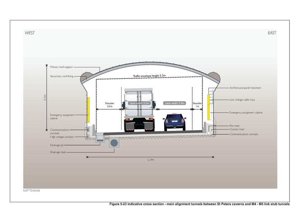
5 5.5 Tunnels Main alignment tunnels The main alignment tunnels would be about nine kilometres long, with the western tunnel portals located at Kingsgrove and the eastern ramp portals located at the St Peters interchange. The eastern end of the main alignment tunnels would terminate underground at St Peters in the form of stub tunnels, providing a potential future connection to the future M4-M5 link. The project has been designed to connect to the existing road network at two locations: The King Georges Road interchange, the M5 East Motorway and M5 South West Motorway via the western portals The St Peters interchange and local surface road network via the eastern portals. Tunnel stubs would also be included to potentially provide a connection to: The future Southern extension via stub tunnels at the Southern extension caverns near the Kogarah Golf Course The future M4-M5 Link via stub tunnels at the St Peters caverns near the St Peters interchange. The width of excavation would be widened at these locations to allow the tunnel stubs to diverge from the main alignment tunnels. This would result in the development of a void or cavern between the two tunnels. The main alignment tunnels include two vehicular cross passages at Bexley and Arncliffe to allow for emergency traffic switching, as well as pedestrian cross passages spaced at a maximum of 120 metres and emergency pedestrian egress between tunnels in the event of an emergency. An indicative cross passage layout is shown on Figure The main alignment tunnels would also include a breakdown bay around the Cooks River between the Southern extension caverns and St Peters caverns. The breakdown bay would be large enough to allow a B-triple vehicle to pull over into the bay and safely park outside of the nominal tunnel shoulder width. The main alignment tunnels would be widened at this location to accommodate the breakdown bay outside of the shoulders. The speed limit within the main alignment tunnels would be 80 kilometres per hour. Tunnel portals The New M5 western tunnel portals would be located at Kingsgrove and would connect to the western surface works. The western tunnel portals would be staggered, with the eastbound portal meeting the surface around 90 metres further west than the westbound tunnel portal. The eastern tunnel portals would connect to the surface at the St Peters interchange, about 70 metres east of Canal Road. Figure 5-18 to Figure 5-20 show indicative configurations of the western and eastern tunnel portals respectively. Dive and cut and cover structures would be constructed at the western and eastern tunnel portals to create entry and exit ramps to join surface roads with the main alignment tunnels (refer to Section for more detail). On and off-ramps would vary in size and shape in response to local conditions and would require a number of cuttings and embankments. The eastern and western on and off-ramps have been designed to provide for a 5.3 metre vertical clearance. The main alignment tunnels at the western and eastern tunnel portals would be line marked for two lanes with the provision to be widened in the future to three and up to five lanes (respectively), subject to additional assessment and approval. WestConnex New M5 5-45
6 (blank page) WestConnex New M5 5-46
7
8 (blank page) WestConnex New M5 5-48
9
10 (blank page) WestConnex New M5 5-50
11
12 (blank page) WestConnex New M5 5-52
13
14 (blank page) WestConnex New M5 5-54
15 Tunnel gradients The crossfall across the carriageway in each of the main alignment tunnels would be 2.5 per cent. This would allow water to drain to the low side of each main alignment tunnel for collection and management as part of the tunnel water management system (refer to Section 5.8.3). The vertical gradient along each of the main alignment tunnels would typically be between 0.5 per cent and one per cent, with the exception of the following locations: Near the western portals, where the eastbound carriageway would have a down-gradient of around five per cent and the westbound carriageway would have an up-gradient of four per cent. These gradients are required due to local geology and minimum separation distances from surface developments Immediately west of the Southern extension tunnel stubs. In this area, a section of around 600 metres of carriageway in both directions would be required at a gradient of around 2.8 per cent. This gradient is required to provide enough space for potential construction of the Southern extension in the future Near the eastern portals at the St Peters interchange, where the eastbound and westbound carriageways would have an up-gradient of around five per cent and a down-gradient of around six per cent, respectively. This gradient is required to balance the depth of tunnelling with reducing the extent of excavations within the Alexandria Landfill site. The main alignment tunnels fall towards a common low point around the Kogarah Golf Course, Arncliffe, where tunnel drainage would connect to surface water treatment facilities (Section 5.8.3). A geotechnical long section of the main alignment tunnels is provided in Appendix C. Lane configuration The configuration of traffic lanes within the main alignment tunnels would be provided in three distinct sections, separated by: The Southern extension caverns, where stub tunnels would be constructed for potential future connection to the Southern extension The St Peters caverns, where stub tunnels would be constructed for potential future connection to the future M4-M5 Link. A summary of the lane configuration and widths of the three sections of the main alignment tunnels is provided in Table 5-2. Typical cross sections within the main alignment tunnels and the New M5 ramps are shown in Figure 5-21 to Figure Table 5-2 Main alignment tunnel section Main alignment tunnels lane configuration and widths Number of lanes Width of lanes (metres) Width of nearside shoulder (metres) Width of offside shoulder (metres) In-tunnel barrier to barrier width (metres) Western portals to the Southern extension caverns 2* Southern extension caverns to the St Peters caverns and 2** eastern portals Stub tunnels from the St Peters caverns for potential future connection to the 2* future M4-M5 Link. New M5 ramps *Main alignment tunnels within these sections would be linemarked for two lanes with the provision to be widened to three in the future, subject to separate assessment and approval. **Main alignment tunnels within this section would be linemarked for two lanes, with the provision to be widened to five in the future, subject to separate assessment and approval. WestConnex New M5 5-55
16 (blank page) WestConnex New M5 5-56
17
18 (blank page) WestConnex New M5 5-58
19
20 (blank page) WestConnex New M5 5-60
21
22 (blank page) WestConnex New M5 5-62
23
24 (blank page) WestConnex New M5 5-64
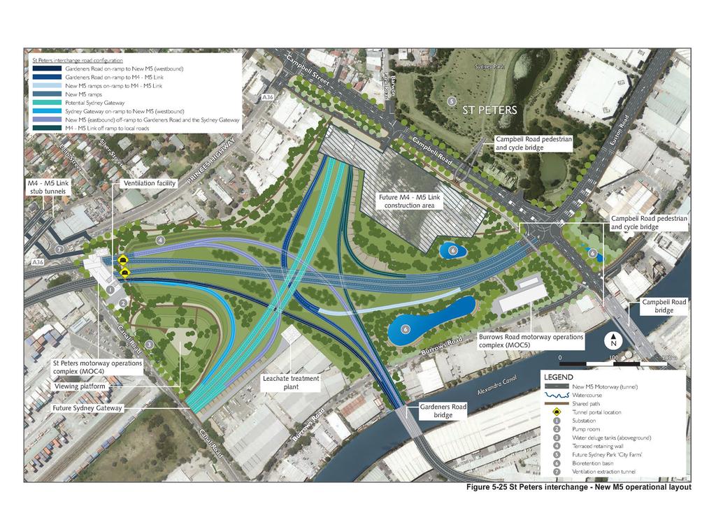
25 5.5.2 M4-M5 Link stub tunnels The main alignment tunnels would be continued north of the St Peters caverns, for around one kilometre to a point underground around Canal Road, to form stub tunnels for potential connection to the future M4-M5 Link. The stub tunnels would continue in the same configuration as the two lane sections of the main alignment tunnels, but would not be opened to traffic as part of the New M5 project. The stub tunnels would be managed and maintained to allow for connection to the future M4-M5 Link. The M4-M5 Link stub tunnels would only be operational after being connected to the future M4-M5 Link Southern extension stub tunnels Stubs tunnels would be constructed in a southerly direction from the Southern extension caverns near the Kogarah Golf Course. These stub tunnels would extend about 20 metres and would provide for a potential connection to the future Southern extension. The stub tunnels would continue in the same configuration as the two lane sections of the main alignment tunnels, but would not be opened to traffic as part of the project. The stub tunnels would be managed and maintained to allow for connection to the Southern extension in the future. The Southern extension stub tunnels would only be operational if connected to the Southern extension in the future. 5.6 St Peters interchange The St Peters interchange in its ultimate configuration (ie in the event the entire WestConnex program of works is completed) would connect the New M5, the future M4-M5 Link and the future Sydney Gateway with: Euston Road at the intersection of Campbell Road Gardeners Road at the intersection with Kent Road via a new bridge over the Alexandra Canal Sydney Airport and Port Botany via the future Sydney Gateway. The construction of all roads within the operational footprint of St Peters interchange would be constructed as part of this project; however, some sections of road would not connect to any operating roads. The project operational layout of the St Peters interchange is shown on Figure The ultimate configuration of the St Peters interchange is shown on Figure The configuration of the St Peters interchange and the stages in which it would be constructed are described in Section WestConnex New M5 5-65
26 (blank page) WestConnex New M5 5-66
27
28 (blank page) WestConnex New M5 5-68
29
30 (blank page) WestConnex New M5 5-70
31 5.6.1 Interchange configuration St Peters interchange ultimate configuration The St Peters interchange, in its ultimate configuration (ie in the event the entire WestConnex program of works is completed), would be a four level interchange and would include seven bridges connection. It would provide connections between: The New M5 and Euston Road at the intersection of Campbell Road The New M5 and Gardeners Road The New M5 and the future Sydney Gateway The future M4-M5 Link and the future Sydney Gateway The future M4-M5 Link and Gardeners Road The future M4-M5 Link and Euston Road at the intersection of Campbell Road. Construction staging The St Peters interchange would be constructed as part of the project. Construction of the St Peters interchange would include: The closure of the former Alexandria Landfill site (refer to Section 5.9) Construction of roads and embankments within the St Peters interchange site Construction of operational ancillary infrastructure associated with the New M5 (refer to Section 6.6.7) Connection of the New M5 with the local road network at the intersection of Euston Road with Campbell Road, and with Gardeners Road via a new bridge over the Alexandra Canal Landscaping and revegetation works within the interchange site. Construction of the St Peters interchange would allow for two additional future stages to provide connections between the St Peters interchange and the: Future M4-M5 Link Future Sydney Gateway. The additional future stages of works would provide the ultimate connectivity through the interchange between the New M5, the future M4-M5 Link, the future Sydney Gateway and the local road network. These stages would be subject to future environmental assessment and approval. The construction of all roads within the St Peters interchange site would be delivered as part of this project. The road construction works within the Alexandria Landfill site, would include landforming and construction of embankments as part of the Alexandria Landfill closure plan. All roads that form part of St Peters interchange would be constructed as part of the initial stage with the aim of minimising potential disruptions to the operation of the New M5 and local road connections during construction of the additional future stages of the WestConnex program of works. Sections of road that provide the following road connections would be constructed within the boundary of the St Peters interchange site but would not connect to any operating roads as part of the initial stages of interchange construction: The New M5 and the future Sydney Gateway The future M4-M5 Link and the future Sydney Gateway The future M4-M5 Link and Gardeners Road The future M4-M5 Link and Euston Road at the intersection of Campbell Road. WestConnex New M5 5-71
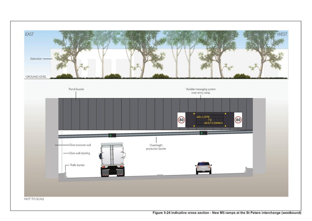
32 As these roads approach the boundary of the interchange site, embankments would be constructed and stabilised. It is anticipated that if the future M4-M5 Link and the future Sydney Gateway projects proceed, they would tie-in to these embankments to complete the interchange and provide operational connections. Landscaping and revegetation works within the St Peters interchange site would be undertaken across the site in accordance with an urban design concept plan (refer to Chapter 14 (Visual impacts and urban design) and Appendix L (Urban design report). A section of the interchange site immediately south-west of Campbell Road and south of Albert Street, would be kept as an area of hardstand, with the anticipation of it being used to support construction of the future M4-M5 Link (refer to Figure 5-25). As part of the project, this area would be physically separated from the remainder of the interchange to restrict access. The intersection of Campbell Road and Euston Road would be upgraded to safely and efficiently manage traffic entering and leaving the St Peters interchange. The upgraded intersection would be integrated with other local surface road improvements (refer to Section 5.7.2). The upgraded intersection would be signalised and would allow motorists to: Exit the eastbound New M5 or the future southbound M4-M5 Link main alignment tunnels along the off ramps and either turn left onto Campbell Road, or continue straight along Euston Road Enter the westbound New M5 or the future northbound M4-M5 Link main alignment tunnel by turning left or right from Campbell Road, or travelling straight from Euston Road, to connect to the on ramps Continue to travel along Campbell Road (local through traffic). An indicative layout of the upgraded intersection is provided in Figure The connection of the road network at the intersection of Campbell Road and Euston Road to the future M4-M5 Link would be constructed as part of the project, with the aim of minimising potential disruptions to the operation of the New M5 and local road connections during construction of the additional future stages of the WestConnex program of works. This road connection would only be operational if connected to the future M4-M5 Link. Within the St Peters interchange connections between the New M5 and Euston Road at the intersection of Campbell Road and between the future M4-M5 Link and the future Sydney Gateway would be via two-lane carriageways with 3.5 metre wide lanes. These two connections would be signposted with a speed limit of 80 kilometres per hour, and would transition to 60 kilometres per hour at the Campbell Road intersection with Euston Road. All other connections within the interchange would be via single-lane carriageways with lanes around 3.5 metres in width. These ramps within the interchange would be signposted at 60 kilometres per hour, with advisory speed signs as required. A cross section showing the indicative lane configuration and lane widths of the New M5 ramps between the eastern portals and the upgraded Campbell Road / Euston Road intersection is provided on Figure Bridges and structures The St Peters interchange would comprise seven bridges which would provide direct connectivity between the New M5, the future Sydney Gateway, the future M4-M5 Link and the local road network. Retaining walls within the interchange would be required to retain batter slopes where the level difference and the distance between the adjacent roadways and the boundaries do not allow the use of batter slopes. WestConnex New M5 5-72
33 A summary of the roadway bridge structures within the interchange is provided in Table 5-3 and shown in Figure An indicative cross section of the St Peters interchange is shown on Figure Bridges within the interchange would be constructed at three general levels, with level one being at the ground surface: Level two (closest to the ground): Level three: Level four: New M5 to Gardeners Road New M5 to the future Sydney Gateway The future Sydney Gateway to the future M4-M5 Link The future M4-M5 Link to the future Sydney Gateway Gardeners Road and Euston Road, at the intersection with Campbell Road, merging and connecting to the future M4-M5 Link. The multi-level design of the interchange would provide grade-separated connectivity and efficient connections between roads without the need to provide traffic signals. It would also remove any direct interfacing of traffic travelling in opposing directions and would allow posted speed limits to be maintained, providing safe and efficient connections between roads. A new pedestrian and cycle bridge would be provided that connects Sydney Park to Mascot. The new bridge would be delivered as part of the project to improve pedestrian and cyclist accessibility (refer to Chapter 9 (Traffic and transport)). This bridge would be delivered as part of the local road upgrades component of the project and is discussed in more detail in Section Retaining walls within the interchange would be located: Between the New M5 ramps and the Princes Highway Along the future Sydney Gateway on and off-ramps near Canal Road Along the Gardeners Road bridge extension near Burrows Road Pedestrian access Three new pedestrian pathways would be provided around the St Peters interchange to enhance pedestrian connectivity. These pedestrian pathways are shown on Figure 5-25 and would include: Parallel to the Princes Highway along the north-western site boundary, providing a pedestrian connection between the Princes Highway at the intersection of Canal Road and Campbell Street, near the intersection of Albert Street Along the northbound (western) side of Canal Road Between the future Sydney Gateway and the Princes Highway, providing a pedestrian connection between the future Sydney Gateway crossing of Canal Road with the Princes Highway at the intersection with Canal Road. WestConnex New M5 5-73
34 (blank page) WestConnex New M5 5-74
35 Table 5-3 Bridge number Bridge Level St Peters interchange road bridges Connectivity Number of lanes Minimum lane width (metres) Shoulder width (indicative) 1 2 New M5 (eastbound) to Gardeners Road (eastbound) Two metre nearside One metre offside 2 2 New M5 (eastbound) to the future Sydney Gateway Two metre nearside One metre offside 3 3 The future Sydney Gateway (northbound) to the future metres nearside M4-M5 Link (northbound) One metre offside 4 3 The future M4-M5 Link (southbound) to the future Sydney metres nearside Gateway (southbound) One metre offside 5 2 The future M4-M5 Link (southbound) to Gardeners Road Two metres (eastbound) nearside One metre offside 6 4 Gardeners Road and Euston Road, at the intersection with Campbell Road, merging and connecting to the future M4-M5 Link Two metre nearside One metre offside Total carriageway width (metres) (indicative) Posted speed (km / h) WestConnex New M Environmental Impact Statement
36 (blank page) WestConnex New M5 5-76
37 ST PETERS INTERCHANGE BRIDGES - PLAN NORTH 5 SOUTH w Ne M M5 Bridge abutment ps Ram Reinforced concrete pier New Reinforced concrete pier ad Gardners Ro Bridge abutment ramp Gardeners Road onto M4 - M5 Link e 3) (WestConnex Stag New y wa at e yg e n Syd to mp -ra on M5 ps Ram on-ramp Potential Sydney Gate way ney Gateway Potential Syd New M5 (ea st bound) off-ramp to Sydne way y Gate NOT TO SCALE ST PETERS INTERCHANGE BRIDGES - SECTION Approach slab Bridge deck N S W Interchange bridge Reinforced concrete pier Twin rail safety barrier Bridge abutment THORNTON N S W THORNTON N S W C VAHTRA 1 Interchange bridges NOT TO SCALE Refer to Figure 5-26 for section location Figure 5-27 Indicative St Peters interchange bridges plan and section
38 (blank page) WestConnex New M5 5-78
39 WEST Security fence EAST Terraced retaining walls, revegetated with native trees and shrubs N S W Vegetated median to create visual separation of carriageway C VAHTRA 1 N S W Gardeners Road on-ramp (eastbound) Capped spoil mounding revegetated with native trees and shrubs New M5 eastbound carriageway C BENNETT New M5 westbound carriageway Gardeners Road off-ramp (westbound) NOT TO SCALE Figure 5-28 Indicative cross section - St Peters interchange
40 (blank page) WestConnex New M5 5-80
6 BRIDGES. 6.1 Design philosophy. Proposed bridges
 SECTION 6 BRIDGES 6 BRIDGES Throughout the Project, bridges are a key visual element and marker for road users, pedestrians and cyclists. The design of bridges, as with other visible structures, has been
13 Land use and property
 13 Land use and property This chapter assesses land use and property impacts associated with the project. The assessment includes: Identification of the local land uses, existing access arrangements and
5.7.6 St Peters Interchange Portal
 5.7.6 St Peters Interchange Portal Design intent At St Peters interchange the design approach to the tunnel portals differs from that adopted for the western portals at Kingsgrove. An entirely different
M4-M5 Link Rozelle Interchange factsheet 2017
 M4-M5 Link Rozelle Interchange factsheet 017 WestConnex is part of the ustralian and NSW governments vision for supporting Sydney s growing population and keeping our economy strong. The M4-M5 Link is
WestConnex. New M5 State Significant Infrastructure Application Report. November 2014 ISBN:
 WestConnex New M5 State Significant Infrastructure Application Report November 2014 ISBN: 978-1-925217-04-9 (blank page) The New M5 November 2014 Prepared for Prepared by AECOM Australia Pty Ltd Level
NEWSLETTER #03 BEAUDESERT ROAD LOGAN MOTORWAY
 NEWSLETTER #03 MT. LINDESAY HIGHWAY Feedback shapes design changes Thank you to the more than 600 stakeholders and community members that provided feedback on the Logan Enhancement Project initial concept
West Gate Tunnel Project. Incorporated Document May Incorporated document pursuant to section 6(2)(j) of the Planning and Environment Act 1987.
(j) of the Planning and Environment Act 1987.") West Gate Tunnel Project Incorporated Document May 2017 Incorporated document pursuant to section 6(2)(j) of the Planning and Environment Act 1987. Drafting Note: The planning control contained in this
West Gate Tunnel Project Incorporated Document May 2017 Incorporated document pursuant to section 6(2)(j) of the Planning and Environment Act 1987. Drafting Note: The planning control contained in this
4.1 Build Alternative 1 Construction Phasing
 SECTION 4 Implementation Plan This section discusses potential segmentation of the build alternatives into multiple projects for implementation of improvements to the NSH from Rabbit Creek Road to 36th
TRANSPORTATION COMMITTEE
 TRANSPORTATION COMMITTEE CITY OF OTTAWA Ministry of Transportation Detailed Design Assignment G.W.P.# 4058-01-00 Highway 417 (Ottawa Queensway) Widening & Rehabilitation from Maitland Avenue to Island
BACKGROUND INFORMATION DOCUMENT
 BACKGROUND INFORMATION DOCUMENT PROPOSED UPGRADING OF THE N2 NATIONAL ROAD FROM KRAAIBOSCH TO DIE VLEIE BASIC ENVIRONMENTAL IMPACT ASSESSMENT The South African National Roads Agency Society Limited (SANRAL)
Moving The Metro. A special construction update for the metro Omaha area.
 Moving The Metro A special construction update for the metro Omaha area. ebraska Department of Roads Spring/Summer 2017 I-80 / I-480 / US-75 Interchange The improvements on this project consist of bridge
Chapter 27 Route Window SE7 Church Manorway Bridge. Transport for London
 Chapter 27 Route Window SE7 Church Manorway Bridge Transport for London CHURCH MANORWAY BRIDGE 27 Route Window SE7 Church Manorway bridge Introduction 27.1 The North Kent Line will be converted to four
7.5 Impacts on the Section 4(f) Properties
 Properties") constructive use, such as noise, air quality and visual impacts were also assessed. It was determined that this project would not introduce changes of an external nature that would affect the recreational
constructive use, such as noise, air quality and visual impacts were also assessed. It was determined that this project would not introduce changes of an external nature that would affect the recreational
CITY OF SYDNEY SUBMISSION ON WESTCONNEX STAGE 3 M4-M5 LINK CONCEPT DESIGN (RELEASED MAY 2017)
") CITY OF SYDNEY SUBMISSION ON WESTCONNEX STAGE 3 M4-M5 LINK CONCEPT DESIGN (RELEASED MAY 2017) EXECUTIVE SUMMARY The City of Sydney strongly objects to and opposes WestConnex. This expensive toll road project
CITY OF SYDNEY SUBMISSION ON WESTCONNEX STAGE 3 M4-M5 LINK CONCEPT DESIGN (RELEASED MAY 2017) EXECUTIVE SUMMARY The City of Sydney strongly objects to and opposes WestConnex. This expensive toll road project
Victoria Bridge Municipal Class EA Civic Works Committee
 Municipal Class EA John Pucchio, P. Eng., Project Manager June 19 2018 Introduction Existing Conditions Municipal Class EA Proposed Bridge Proposed Road Reconstruction Proposed Improvements Construction
APPENDIX D: Visual and Aesthetic Conditions for NCCU Station Refinement. Durham-Orange Light Rail Transit Project
 APPENDIX D: Visual and Aesthetic Conditions for NCCU Station Refinement Durham-Orange Light Rail Transit Project October 2016 1. Introduction The Combined FEIS/ROD summarizes the effects of the D-O LRT
Western Belfast Bypass almost finished
 ROADS OF NATIONAL SIGNIFICANCE CHRISTCHURCH MOTORWAYS Western Belfast Bypass PROJECT UPDATE October 2017 Western Belfast Bypass almost finished The Western Belfast Bypass (WBB) project is 95 per cent complete
Start of works exhibition
 Start of works exhibition Find out about the work that Highways England are undertaking to create a new interchange junction 700 metres east of junction 10 over the M20, a dual carriageway link road to
Appendix SPAIN Madrid M30-Río-TUNNEL
 Appendix 2.17 - SPAIN Madrid M30-Río-TUNNEL 1. INTRODUCTION The M30-Río Tunnel is located in Madrid (Spain), a city of about 3,200,000 inhabitants. The M30 is the main ring road, linking all the neighbourhoods
ALTERNATIVES. NCDOT made an early decision to first determine how to build the project (construction method) followed by what to build (alternatives).
 followed by what to build (alternatives).") III. ALTERNATIVES A. CONSTRUCTION METHOD ALTERNATIVES NCDOT made an early decision to first determine how to build the project (construction method) followed by what to build (alternatives). One of the
III. ALTERNATIVES A. CONSTRUCTION METHOD ALTERNATIVES NCDOT made an early decision to first determine how to build the project (construction method) followed by what to build (alternatives). One of the
Chapter 24 Route Window SE5 Arsenal Way shaft. Transport for London
 Chapter 24 Route Window SE5 Arsenal Way shaft Transport ARSENAL WAY SHAFT 24 Route Window SE5 Arsenal Way shaft Introduction Transport 24.1 South of the River Thames (see Route Window SE4), the tunnel
INFRASTRUCTURE EXISTING INFRASTRUCTURE A. Circulation B. Signals C. Drainage D. Utilities
 7.01. EXISTING INFRASTRUCTURE A. Circulation B. Signals C. Drainage D. Utilities 7.02. PROPOSED INFRASTRUCTURE A. Overall Concept B. Circulation C. Signals D. Drainage 7.03. INFRASTRUCTURE MAP A. Key Infrastructure
1 Metrolinx overview. Mission We connect our communities. Vision Getting you there better, faster and easier
 Mission We connect our communities Vision Getting you there better, faster and easier Values Play as a team Think forward Serve with passion 1 Metrolinx overview go transit, up express, presto Serve a
Open Space, Connectivity and Landscape Design
 6 Open Space, Connectivity and Landscape Design Open space, connectivity and landscape design 6.1 Open Space The inclusion of publicly accessible open space is a key benefit of the project s design. The
Alta Vista Transportation Corridor Environmental Study Report November 2005
 Alta Vista Transportation Corridor Environmental Study Report November 2005 6.0 ALTERNATIVE DESIGNS The Preferred Solution to providing additional transportation system capacity through the AVTC study
E kv Transmission Line Underground Relocation Project. Initial Evaluation of Bridge Structures
 E-183 115 kv Transmission Line Underground Relocation Project Introduction Initial Evaluation of Bridge Structures July 11, 2017 Robinson and Cole, LLP contacted Power Delivery Consultants, Inc. (PDC)
FY STATEWIDE TRANSPORTATION IMPROVEMENT PROGRAM New Jersey Department of Transportation Projects
 Garden State Parkway, Interchange 67, at Bay Avenue, CR 554 NS0210 NS0210 This project will provide new and modified movements to the Garden State Parkway, Interchange 67 at Bay Avenue (CR 554). Currently,
PROPOSED IMPROVEMENTS
 IV. PROPOSED IMPROVEMENTS The proposed improvements for each alternative carried forward are discussed below. A. FUNCTIONAL CLASSIFICATION AND ROADWAY CROSS-SECTIONS The classifications of the roadways
FY STATEWIDE TRANSPORTATION IMPROVEMENT PROGRAM Transportation Authorities Project Descriptions
 Bridge Rehabilitation Burlington County Bridge Commission Burlington-Bristol Bridge This project includes the replacement of the existing span decks, repairs to the existing walkway, railing and ladder
OP Council Resolution June 16, Planning and Development Services
 OP-08-01 Council Resolution June 16, 2008 Planning and Development Services Kingsgate Landing Outline Plan Table of Contents 1.0 Introduction 1 1.1 Purpose of Plan 1 1.2 Plan Area Location 1 1.3 Ownership
Meeting Purpose: Date and Time: Location: Attendance: Handouts:
 Meeting Purpose: Date and Time: Location: Attendance: Handouts: PA Turnpike / I-95 Interchange Project Design Advisory Committee (DAC)/Public Officials Meeting #8 April 12, 2012 at 1:30 p.m. Project Office,
Appendix 18F: Tauriko Business Estate Services Strategy Statement and Sequencing Schedule
 Appendix 18F: Tauriko Business Estate Services Strategy Statement and Sequencing Schedule This statement describes key proposals for the development of infrastructure at Tauriko Business Estate. Appendix
Public Meeting #3 May 9, 2009 MVVA Team
 Public Meeting #3 May 9, 2009 MVVA Team Welcome to the third Public Meeting for the Lower Don Lands Municipal Class Environmental Assessment (EA) Infrastructure Master Plan and Keating Channel Precinct
Purpose of Open House #3
 Public Meeting #3 May 9, 2009 MVVA Team Purpose of Open House #3 The main purpose of this Open House is to present and seek input on the: Evaluation of transportation and infrastructure design alternatives
A. INTRODUCTION B. PROJECT LOCATION
 Chapter 1: Project Description A. INTRODUCTION The Lower Manhattan Development Corporation (LMDC), a subsidiary of the New York State Urban Development Corporation, doing business as the Empire State Development
Rt. 29 Solutions Project Delivery Advisory Panel. January 7, 2016
 Rt. 29 Solutions Project Delivery Advisory Panel January 7, 2016 Agenda item 1: Introductions Project Delivery Advisory Panel Technical Team 2 Agenda item 2: Interaction and Feedback Live Streaming Dec
Proposed Bunnings Warehouse. 90 Benalla Road Shepparton
 90 Benalla Road Shepparton April 2015 CONTENTS 1. Introduction 1 2. Proposed Development 1 3. Existing Conditions 3 3.1 Location and Land Use 3 3.2 Road Network 5 3.3 Turning Movement Counts 8 4. Car Parking
SH20 Manukau Harbour Crossing Project Notice of Requirement Auckland City Council
 19 May 2006 (Updated 28 August 2006) Notice of Requirement Dated 19 May 2006: Updated 28 August 2006 Notice of Requirement Dated 19 May 2006: Updated 28 August 2006 Page i Form 18 Notice of Requirement
I539. Smales 2 Precinct
 I539. Smales 2 Precinct I539.1. Precinct Description The Smales 2 Precinct applies to a 4.8 hectare block of land located on the southern side of Northcote Road and fronting Lake Pupuke, Takapuna. The
WestConnex M4-M5 Link Mini-EIS for Haberfield/Ashfield area
 WestConnex M4-M5 Link Mini-EIS for Haberfield/Ashfield area Need to read chapter 26 cumulative impacts Find worst case scenario notes why not in Wattle St section? Don t forget conveyor belt over Parramatta
Chapter 9 Route window W18 Slough station. Transport for London
 Chapter 9 Route window W18 Slough station Transport SLOUGH STATION 9 Route window W18 Slough station 9.6 Wexham Road bridge worksite north; and Wexham Road bridge worksite south. Uxbridge Road bridge
Section C Bridges and retaining walls
 Section C Bridges and retaining walls Above: This existing bridge on SH2 at Tauranga has a simple tapered column form that is a good precedent for the TEL. The open abutment optimises views along the highway
Mavis Road Class Environmental Assessment
 Mavis Road Class Environmental Assessment Public Information Centre #2 Wednesday November 9, 2016 6:00 to 8:00 p.m. Please sign in and complete a comment sheet Review the displays on your own or join in
20. NEWHAM ROUTE SECTION - ENVIRONMENTAL BASELINE AND ASSESSMENT OF IMPACTS... 2
 20. NEWHAM ROUTE SECTION - ENVIRONMENTAL BASELINE AND ASSESSMENT OF IMPACTS... 2 20.1 OVERVIEW OF NEWHAM ROUTE SECTION... 2 20.2 POLICIES RELEVANT TO ALL WORKSITES IN NEWHAM... 3 20.3 POLICIES RELEVANT
Transmission Gully Project - Urban & Landscape Design Framework
 Technical Report 23 Transmission Gully Project - Urban & Landscape Design Framework August 2011 This document was prepared by LANDSCAPE ARCHITECTURE URBAN DESIGN with inputs from Opus, Holmes Consulting,
Boundaries and Fencing
 Boundaries and Fencing Introduction 7.1 The purpose of this chapter of the design code is to establish design principles and parameters to guide the development and erection of site boundaries within the
Mississippi Skyway Preliminary Engineering Report
 EXECUTIVE SUMMARY Mississippi Skyway Preliminary Engineering Report CITY OF RAMSEY, MINNESOTA DECEMBER 2014 City of RAMSEY EXECUTIVE SUMMARY Project Need and Intent The Mississippi Skyway pedestrian bridge
Edmonton s LRT Setting the Stage for Heading Further South
 4 Capital Projects Project Updates Edmonton s LRT Setting the Stage for Heading Further South Art Washuta, P.Eng. AECOM Canada Ltd. Edmonton, Alberta Carole Cej, P.Eng. City of Edmonton Edmonton, Alberta
Bridge Type Assessment and Evaluation
 16M-01410-01 (3216026) Glen Road Pedestrian Bridge EA Study Bridge Type Assessment and Evaluation Factor Group/Criteria Alternative 1: Steel girder with two inclined steel legs Alternative 2: Steel girder
Rt. 29 Solutions Project Delivery Advisory Panel. December 3, 2015
 Rt. 29 Solutions Project Delivery Advisory Panel December 3, 2015 Agenda item 1: Introductions Project Delivery Advisory Panel Technical Team 2 Agenda item 2: Interaction and Feedback Live Streaming Nov
WestConnex PLAN. Note : This sub-plan is currently not approved by Department of Planning and Environment APPENDIX D
 ARNOTTS RESERVE URBAN DESIGN AND LANDSCAPE SUB- PLAN WestConnex Note : This sub-plan is currently not approved by Department of Planning and Environment 407 TABLE OF CONTENTS D1 INTRODUCTION 410 D1.1 Ministers
Chapter 10 Route window W17 Middlegreen Road, St Mary s Road and Trenches bridges. Transport for London
 Chapter 10 Route window W17 Middlegreen Road, St Mary s Road and Trenches bridges Transport for London MIDDLEGREEN ROAD, ST MARY S ROAD AND TRENCHES BRIDGES 10 Route window W17 Middlegreen Road, St Mary
Michael Sheridan Roads & Maritime Services
 Michael Sheridan Roads & Maritime Services Tunnel urban design guideline: Design guideline to improve the customer and community experience of road tunnels Michael Sheridan Centre for Urban Design Outline
Welcome to the Public Consultation Exhibition
 Welcome to the Public Consultation Exhibition Today is your opportunity to: Speak to the team Learn more about the project Leave feedback on the plans The Secretary of State for Transport has recognised
Construction Engineering & Inspection
 Construction Engineering & Inspection Serving Florida for 20 Years CEI Engineering Planning Landscape Architecture Urban Design Construction Engineering & Inspection (CEI) I N T R O D U C T I O N Over
CHATSWOOD TO SYDENHAM. Project Update NORTHERN SURFACE TRACK WORKS - CHANGES IN CONSTRUCTION METHODOLOGY
 CHATSWOOD TO SYDENHAM Project Update NORTHERN SURFACE TRACK WORKS - CHANGES IN CONSTRUCTION METHODOLOGY AUGUST 2016 1 rthern surface track works changes in construction methodology 1.1 Introduction Section
Chapter 2: OUTLINE PLANNING APPLICATION PROPOSALS. A New Garden Neighbourhood Matford Barton 17
 Chapter 2: OUTLINE PLANNING APPLICATION PROPOSALS A New Garden Neighbourhood Matford Barton 17 2.1. SUMMARY AND STATUS OF THE PROPOSALS 2.1.1. The parameter plans and associated wording in this chapter
Part G: Assessment of Effects on the Environment. 11 Environmental Effects Assessment
 Volume 2: Assessment of Environmental Effects 237 Part G: Assessment of Effects on the Environment 11 Environmental Effects Assessment 11.1 Types of Effects Anticipated The proposed works can be summarised,
Key development locations along the route of the scheme are identified in Chapter 4.
 6 Land Use 6.1 Introduction This chapter describes the effects of the proposed Edinburgh Tram Line One on land uses, including property and community land along the route. In particular it: reviews the
SPECIAL 35 (HIBISCUS COAST GATEWAY) ZONE
 ZONE") `` 12.8.35 SPECIAL 35 (HIBISCUS COAST GATEWAY) ZONE 12.8.35.1 Issues The following provisions relate to the Hibiscus Coast Gateway Zone. This zone is located at Silverdale in the area bounded by State
`` 12.8.35 SPECIAL 35 (HIBISCUS COAST GATEWAY) ZONE 12.8.35.1 Issues The following provisions relate to the Hibiscus Coast Gateway Zone. This zone is located at Silverdale in the area bounded by State
City of Grande Prairie Development Services Department
 City of Grande Prairie Development Services Department ROYAL OAKS NORTH OUTLINE PLAN OP-07-03 NW 35-71-6 W6M May 7, 2007 Royal Oaks North Outline Plan TABLE OF CONTENTS 1.0 INTRODUCTION........ 3 1.1 Purpose
I615. Westgate Precinct
 I615. Westgate Precinct I615.1. Precinct Description The Westgate Precinct is located approximately 18km west of the Auckland city centre. There are seven Sub-precincts in the Westgate Precinct: Sub-precinct
8.8 Sector 8 Hataitai Park
 8.8 Sector 8 Hataitai Park The recreation hub at Hataitai Park Note Badminton Hall at the top of picture and Velodrome at bottom centre. 8.8.1 Character and use The sector occupies the east face of the
I-70 Corridor Enhancement Plan
 i - Table of Contents Table of Contents Chapter I Overview Chapter II Bridge and Roadway Improvements Chapter III Landscape Enhancements Chapter IV Riparian Corridors Chapter V Showcase Missouri Plan Chapter
WELCOME! 8 8:30 6: TH STREET IMPROVEMENTS. Open House. Presentation & Q&A
 WELCOME! 168 TH STREET IMPROVEMENTS 6:30 Open House 7 8 Presentation & Q&A 8 8:30 Open House WELCOME Todd Pfitzer City of Omaha Engineer Bob Stubbe City of Omaha Public Works Director Jon Meyer Project
FY STATEWIDE TRANSPORTATION IMPROVEMENT PROGRAM New Jersey Department of Transportation Projects
 Route 1&9, County Road 99380 99380 Improvements are planned at the Route 1&9, County Road intersection to address operational and safety issues in the vicinity of Manhattan Avenue and County Road. COUNTY:
3.5.7 Black Creek to Don Mills
 Toronto Transit Commission/City of Toronto 3.5.7.2 Keele Station Keele Station will be located at the intersection of Eglinton Avenue and Trethewey Drive/Keele Street. It will be the western-most station
21. GREENWICH ROUTE SECTION ENVIRONMENTAL BASELINE AND ASSESSMENT OF IMPACTS... 2
 21. GREENWICH ROUTE SECTION ENVIRONMENTAL BASELINE AND ASSESSMENT OF IMPACTS... 2 21.1 OVERVIEW OF GREENWICH ROUTE SECTION... 2 21.2 POLICIES RELEVANT TO ALL WORKSITES IN GREENWICH... 3 21.3 WARREN LANE
25 Crime Prevention through Environmental Design (CPTED)
") Volume 2: Assessment of Environmental Effects 412 25 Crime Prevention through Environmental Design (CPTED) Overview The purpose of this Chapter is to provide a Crime Prevention Through Environmental Design
Volume 2: Assessment of Environmental Effects 412 25 Crime Prevention through Environmental Design (CPTED) Overview The purpose of this Chapter is to provide a Crime Prevention Through Environmental Design
B2B Project Team Responses to Nga Potiki Draft Addendum
 B2B Project Team s to Nga Potiki Draft Addendum Nga Potiki were introduced into the project in December 2012 and formally meet through the Hapū Advisory Group (Nga Potiki, Ngai Tukairangi and Ngati Tapu)
PROPOSED CAPACITY IMPROVEMENTS TO NA- TIONAL ROUTE 2 (N2) AND NATIONAL ROUTE 3 (N3) WITHIN ETHEKWINI METROPOLITAN MUNICIPALITY
 AND NATIONAL ROUTE 3 (N3) WITHIN ETHEKWINI METROPOLITAN MUNICIPALITY") PROPOSED CAPACITY IMPROVEMENTS TO NA- TIONAL ROUTE 2 (N2) AND NATIONAL ROUTE 3 (N3) WITHIN ETHEKWINI METROPOLITAN MUNICIPALITY BACKGROUND INFORMATION AND INVITATION TO PARTICIPATE IN AN ENVIRONMENTAL AUTHORISATION
PROPOSED CAPACITY IMPROVEMENTS TO NA- TIONAL ROUTE 2 (N2) AND NATIONAL ROUTE 3 (N3) WITHIN ETHEKWINI METROPOLITAN MUNICIPALITY BACKGROUND INFORMATION AND INVITATION TO PARTICIPATE IN AN ENVIRONMENTAL AUTHORISATION
Southern Gateway Project and Public Green
 Southern Gateway Project and Public Green Transportation and Trinity River Project Committee May 23, 2016 Purpose of Presentation Provide the history and an overview of the Southern Gateway Project (SGP)
Highway 417 Expansion East
 Highway 417 Expansion East Nicholas Street to Ottawa Road 174 GWP 4091-07-00 & GWP 4320-06-00 Outline Project Overview Highway 417 Widening Bridge Rapid Replacements Traffic & Incident Management Project
NORTH-SOUTH CORRIDOR STUDY EXECUTIVE SUMMARY. Executive Summary
 Executive Summary Background As congestion continues to affect mobility in the region, the Ozarks Transportation Organization (OTO) is particularly concerned with traffic movement. The North-South Corridor
Places29: List of Implementation Projects
 Important Points to Keep in Mind When Using This List Places29: List of s Each of the projects in this List represents an action needed to implement the Places29 Master Plan. The projects are grouped first
Wide asphalt driveway abutting school property. garage built with incompatible materials, too close to park. incompatible fencing materials
 Wide asphalt driveway abutting school property incompatible fencing materials garage built with incompatible materials, too close to park Lack of plantings as a buffer between private property and open
PROJECT SITE The Proposed Project includes the Allen and Pike Street malls between Delancey and South Streets (see Figure 2C-1).
.") Chapter 2, Section C: A. INTRODUCTION This chapter considers the potential of the proposed Reconstruction of the Allen and Pike Street Malls project to affect the urban design characteristics and visual
Chapter 2, Section C: A. INTRODUCTION This chapter considers the potential of the proposed Reconstruction of the Allen and Pike Street Malls project to affect the urban design characteristics and visual
Derby-Shelton Bridge Pedestrian and Bicyclist Enhancements [1]
![Derby-Shelton Bridge Pedestrian and Bicyclist Enhancements [1]](/thumbs/96/128011958.jpg "Derby-Shelton Bridge Pedestrian and Bicyclist Enhancements [1]") nhancements [1] STATUS OF PROJECT: The project has recently moved from the Preliminary Design Phase to the Final Design Phase following the most recent Public Involvement Meeting held on January 9, 2019
nhancements [1] STATUS OF PROJECT: The project has recently moved from the Preliminary Design Phase to the Final Design Phase following the most recent Public Involvement Meeting held on January 9, 2019
STATUS REPORT ENVIRONMENTAL REVIEW FOR IMPROVED ACCESS. at the NORTH WHITE PLAINS STATION
 STATUS REPORT ENVIRONMENTAL REVIEW FOR IMPROVED ACCESS at the NORTH WHITE PLAINS STATION May 2009 Status Report- Environmental Review for Improved Access at the North White Plains Station A. INTRODUCTION
FANSHAWE PARK ROAD/RICHMOND STREET INTERSECTION IMPROVEMENTS. PUBLIC INFORMATION CENTRE 2 June 16, 2016
 FANSHAWE PARK ROAD/RICHMOND STREET INTERSECTION IMPROVEMENTS Municipal Class Environmental Assessment PUBLIC INFORMATION CENTRE 2 June 16, 2016 ACCESSIBILITY Under the Accessibility Standards 2015 for
4. INITIAL CONCEPT DEVELOPMENT AND SCREENING
 4. INITIAL CONCEPT DEVELOPMENT AND SCREENING A coordinated effort by the project team and members of the three oversight committees (Citizen Advisory, Technical Advisory, and Steering) led to 17 initial
FY STATEWIDE TRANSPORTATION IMPROVEMENT PROGRAM New Jersey Department of Transportation Projects
 69th Street Bridge 02311 02311 A grade separation at 69th Street would eliminate the current at-grade crossing which causes frequent automobile delays due to long freight trains moving through this area.
ST PETERS INTERCHANGE - AERIAL VIEW WEST OVER TUNNEL PORTAL AND MOC4 FACILITY (Artist's impression only subject to change during design development)
") ST PETERS INTERCHANGE - AERIAL VIEW WEST OVER TUNNEL PORTAL AND MOC4 FACILITY (Artist's impression only subject to change during design development) i WESTCONNEX NEW M5 URBAN DESIGN AND LANDSCAPE PLAN
ST PETERS INTERCHANGE - AERIAL VIEW WEST OVER TUNNEL PORTAL AND MOC4 FACILITY (Artist's impression only subject to change during design development) i WESTCONNEX NEW M5 URBAN DESIGN AND LANDSCAPE PLAN
Design and Access Statement
 Design and Access Statement Document: CTRAEB/730/DOC500 South Bristol Link Bristol City Council & North Somerset Council 21 May 2013 Design and Access Statement South Bristol Link Bristol City Council
Second Line West Pedestrian/Cyclist Crossing of Highway 401 Class EA. Second Line West Pedestrian/Cyclist Crossing of Highway 401 Class EA
 1 1 Purpose of Public Information Centre #2 To provide interested and/or potentially affected stakeholders with an opportunity to participate in the planning and decision-making process for this Municipal
Urban Design Manual 2.0 DRIVE-THROUGH FACILITIES. Background. Urban Design Challenges
 222221 2.0 DRIVE-THROUGH FACILITIES Background In recent years, drive-through facilities have grown significantly in popularity with drive-through restaurants, in particular, being established on numerous
20 Non-Aboriginal heritage
 20 Non-Aboriginal heritage A Technical working paper: Non-Aboriginal heritage (Appendix R) has been prepared to assess the potential impact of the project on non-aboriginal heritage. This chapter provides
Appendix E Preliminary Location Hydraulic Study
 Appendix E Prepared for: State of Alaska Department of Transportation and Public Facilities Prepared by: HDR Alaska, Inc. 2525 C Street, Suite 305 Anchorage, Alaska 99503 February 2014 This page intentionally
North West Rail Link - Environmental Assessment Urban Design and Visual Assessment Prepared for Transport Infrastructure Development Corporation
 North West Rail Link - Environmental Assessment Urban Design and Visual Assessment Prepared for Transport Infrastructure Development Corporation November 2006 HASSELL Ltd 007 711 435 88 Cumberland Street
City of Cornwall Municipal Class Environmental Assessment. Proposed Improvement and Extension of Lemay Street
 Welcome City of Cornwall Municipal Class Environmental Assessment Proposed Improvement and Extension of Lemay Street Redevelopment and Design of the Municipal Works Yard Public Information Centre #1 Thursday,
Development Control Plan No Wolli Creek
 Development Control Plan No. 62 - Wolli Creek Effective from 18 August 2006 Prepared by Urban Planning Unit 1.1 Preliminary 1.1.1 Name of this plan This plan is Rockdale Development Control Plan No.
A. INTRODUCTION B. NO ACTION ALTERNATIVE
 Chapter 19: Alternatives A. INTRODUCTION Over the years a variety of potential developments for the East River waterfront in Lower Manhattan have been considered. Some of these plans were very ambitious
Chapter 10. Route Window C5: Tottenham Court Road East
 Chapter 10 Route Window C5: Tottenham Court Road East 112 Crossrail 10 Route Window C5: Tottenham Court Road East 10.1 Summary of Residual Impacts 10.1.1 The following significant residual adverse impacts
BACKGROUND, GOALS, STUDY AREA, EVALUATION CRITERIA, ORGANIZATION
 CHAPTER 1 BACKGROUND, GOALS, STUDY AREA, EVALUATION CRITERIA, ORGANIZATION 1.0 INTRODUCTION The Executive Office of Transportation and Public Works Office of Transportation Planning (Planning) initiated
Lincoln Road Corridor Improvements. Notice of Requirement to Auckland Council from Auckland Transport. Assessment of Effects on the Environment (AEE)
") Lincoln Road Corridor Improvements Notice of Requirement to Auckland Council from Auckland Transport Assessment of Effects on the Environment (AEE) 1 Assessment of Effects on the Environment prepared by:
Lincoln Road Corridor Improvements Notice of Requirement to Auckland Council from Auckland Transport Assessment of Effects on the Environment (AEE) 1 Assessment of Effects on the Environment prepared by:
FY 2005 TRANSPORTATION CAPITAL PROGRAM
 Camden County Civic Center Access Study, Pennsauken 03340 This project will address operational and access improvements on Routes 30, 73 and 90 related to the Crossroads redevelopment project around the
Chapter 8. Visualizations
 Examples of Effective Techniques for Improving the Quality of Environmental Documents Chapter 8. Visualizations Visualizations help the reader to see what the project would look like in the real world.
July 12, Columbus City Council City Hall 90 West Broad Street Columbus, OH RE: I-70/71 Columbus Crossroads Project
 OHIO DEPARTMENT OF TRANSPORTATION DISTRICT 6 400 EAST WILLIAM STREET DELAWARE, OHIO 43015 800.372.7714 Columbus City Council City Hall 90 West Broad Street Columbus, OH 43215-9015 RE: I-70/71 Columbus
LAND USE SHEET 3 LOWER THAMES CROSSING LOWER THAMES CROSSING STATUTORY CONSULTATION. Main works construction compound
 1 19 1 Sheet 19 19 Sheet 19 Sheet 13 Sheet 13 Sheet 11 Sheet 11 Sheet Sheet 10 11 Sheet Sheet 10 11 a a Sheet 10 Sheet 10 a a a Sheet a5 Sheet 1 Sheet 1 HE540039-CJV-GEN-SZP_GN000000_Z-DR-CX-00304.dwg
Adelaide Street / Canadian Pacific Railway (CPR) Grade Separation Class Environmental Assessment. Public Information Centre 3
 Grade Separation Class Environmental Assessment. Public Information Centre 3") 1 Adelaide Street / Canadian Pacific Railway (CPR) Grade Separation Study Process and Purpose of PIC 3 2 Study Commencement February 2016 Phase 1: Problem and Opportunity Identify problems and opportunities
1 Adelaide Street / Canadian Pacific Railway (CPR) Grade Separation Study Process and Purpose of PIC 3 2 Study Commencement February 2016 Phase 1: Problem and Opportunity Identify problems and opportunities