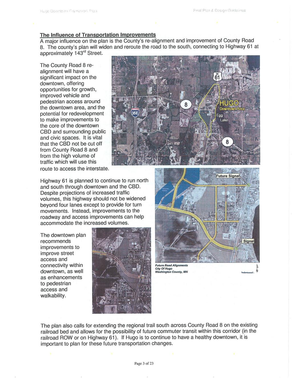
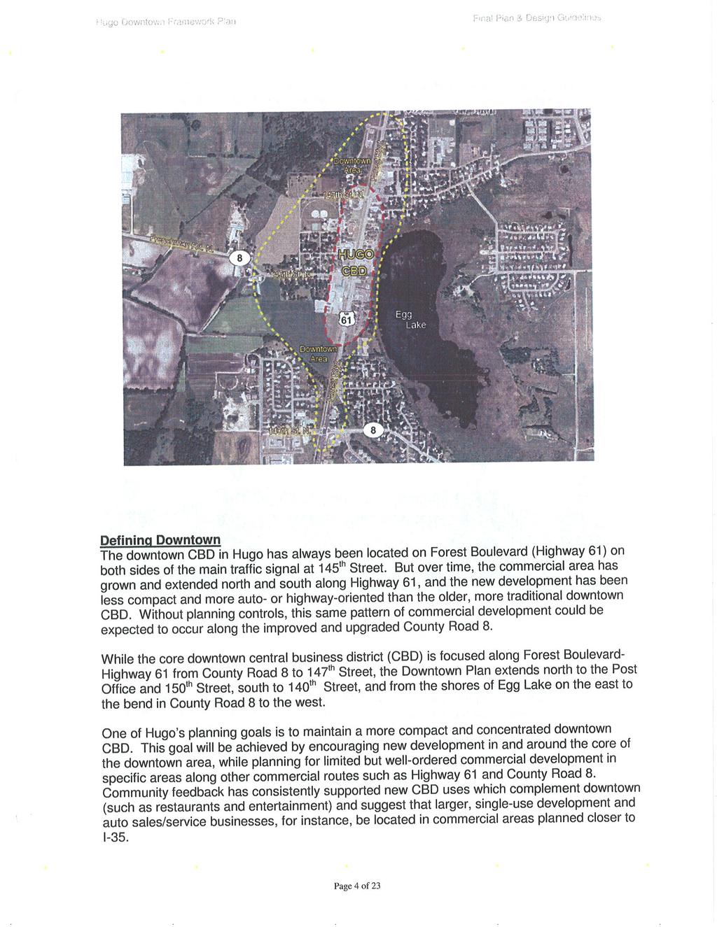
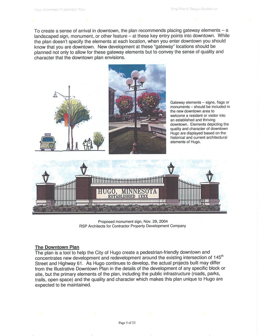
Chapter 4: Land Use Plan
|
|
|
- Branden Grant
- 5 years ago
- Views:
Transcription
1 Chapter 4: Plan 4.1. GENERAL DEVELOPMENT POLICIES Chapter Purpose The Plan is the foundation of the City s Comprehensive Plan. The plan identifies where people will live, work, shop and play. Development anticipated in the plan drives the need for all types of infrastructure, including sewer, water, roads, and parks. In addition, the Plan helps the Planning Commission and City Council make decisions on individual development requests. Perhaps most importantly, the way land is used and the way in which uses are arranged are major contributors to a community's quality of life. The purpose of the Plan is to: 1) identify appropriate locations for all types of land use; 2) specify criteria for determining the appropriate location for a specific land use; 3) layout strategies to ensure that all the various types of uses exist together harmoniously and 4) provide critical background data for infrastructure planning. Development Approach Rapid residential development in the region from the late 1990s through 2005 caused the City of Hugo to reevaluate development opportunities in the City. The City Council authorized an extensive public participation process to update the Comprehensive Plan in A large area of the City has been added to the Metropolitan Urban Service Area (MUSA) and is expected to develop within the timeframe of this comprehensive plan. To address this, the City Council conducted a public process to identify areas that may develop between now and The Plan reflects these potential changes. The 2030 Plan (Map 7-A) shows minimal change from the 2020 Land Use Plan for the currently urbanized area of Hugo. However, the City identified four key areas where land use may undergo change. The areas include: 1) Downtown Hugo 2) The property at the northeast corner of Highway 61 and 120 th Street 3) The property at the intersection of Highway 61 and 140 th Street 4) The property in northwest Hugo that was previously guided Future Urban Service Area Furthermore, the City finds that eastern Hugo has natural resources that make development east of Judicial Ditch 2 challenging; therefore, the City has generally used this ditch as the physical boundary between the urban areas of Hugo and the rural areas of Hugo north of Egg Lake. The MUSA boundary reflects the 2030 MUSA. Chapter 4 4-1
2 Public Participation Process The Comprehensive Planning process began in 2007 with a series of open houses and public workshops. Each public meeting provided an opportunity for residents to provide written and verbal comments. All comments were provided to the Planning Commission and City Council and were one of the sources used to prepare this plan. Classifications The following table provides a breakdown of future land use for each land use classification in the 2030 Plan. Table 4-1. City of Hugo 2030 Plan Gross Acres Developable Acres* Percent of Total Developable Land in the City Agriculture 8,180 6, % Large Lot Residential 3,817 3, % Very Low Density Residential % Low Density Residential 6,042 2, % Medium Density Residential 1, % High Density Residential % Mixed Use % Commercial % Business Park % Industrial % Public/Quasi-Public % *Developable Acres = gross acreage developed land acreage wetland acreage floodplain acreage When interpreting the 2030 Plan (Map 7-A), the City will use the following guidelines: Where applicable, the boundary between two land use classifications shall be considered to extend to the center of an adjacent street. In undeveloped areas, the classifications on the plan assume that the boundary between classifications will follow major roads. Consequently, if the final alignment of a road changes from that shown on the map, the line on the 2030 Plan will also move to reflect the adjusted road alignment. For the different residential, commercial and industrial classifications, there is more than one corresponding zoning district that may be applicable to a particular site depending on: 1) the type and density/intensity of uses; 2) compatibility with the Comprehensive Plan, including public facilities (e.g. transportation and sanitary sewer); and 3) the purposes of the individual zoning district. Chapter 4 4-2
3 Mixed Use Mixed use development allows the mixing of higher intensity land uses in one building or the physical integration of different uses on the same lot or within close proximity. Typically, mixed use includes a combination of retail, office, cultural or entertainment uses with higher density residential use. However, these uses can occur without housing and still be considered mixed use. To date, the City has not processed any mixed use projects. Hugo will allow mixed use to occur with or without housing as a component. Mixed use developments will be processed as a planned unit development (PUD), with the location of specific uses and development criteria for the entire site determined through that process. Consistency with Local Controls State law requires consistency between a community's comprehensive plan and official controls. Whenever the City makes a change to its Comprehensive Plan, the City will review its official controls, including the Zoning Ordinance, to identify possible inconsistencies between the adopted plan and official controls. An inconsistency would be any official control that is in direct conflict with the goals and policies of the Comprehensive Plan. To maintain consistency between the 2030 Plan and Zoning Map, the City will only rezone property consistent with the Plan. The City has established a uniform process and criteria for amending the Land Use Plan. The description of the process and review criteria is found in Appendix 4A. Chapter 4 4-3

4 4.2. EXISTING LAND USE GENERAL DEVELOPMENT POLICIES VISION The City of Hugo is 36 square miles in size. Located in northwestern Washington County, Hugo is bounded on the north by Forest Lake, on the east by May Township, on the south by Grant and White Bear Township, and on the west by the City of Lino Lakes. Hugo is part of the seven county metropolitan region. The City is designated by the Metropolitan Council as a developing community and partially as a diversified rural geographic planning area in the 2030 Regional Development Framework. The Metropolitan Council defines these areas as follows: Figure 4.1 Metropolitan Council Geographic Planning Area Developing Communities Developing area is that portion of the region that is in the path of urban growth. It includes the communities beyond the fully developed area up to the metropolitan urban service area boundary, or contains areas designated urban reserve or diversified rural. Diversified Rural Area - Sparsely developed parts of the region outside of Rural Settlements, Rural Residential Areas and the Permanent Agriculture Area that contain the widest variety of farm and nonfarm land uses in patterns often referred to as rural character. These are the parts of the region designated as appropriate locations for a mix of large-lot residential and clustered housing with agriculture and other uses, including facilities and services of value to the metropolitan area but requiring a rural location (nurseries, campgrounds, etc.). Approximately 5,613 acres in western Hugo is located in the 2020 Metropolitan Urban Service Area (MUSA). This designation allows development of land to occur at urban densities with urban infrastructure of city water and sewer facilities. Chapter 4 4-4
5 LAND USE PLAN Classifications Residential s Residential use is and will be the predominant land use in the City. The Land Use Plan will provide for a broad range of housing opportunities within different density ranges. Each of the density ranges will eventually contain a set of corresponding zoning districts that may be applied. More than one zoning district may be applicable to a particular site depending on: 1) the type and density of uses: 2) compatibility with the Comprehensive Plan, including public facilities (e.g. transportation and sanitary sewer); and 3) the purposes of the individual zoning district. Furthermore, all residential development must comply with the Zoning Ordinance requirements and any adopted guideline, such as the Multi-Family Design Guidelines. Chapter 4 4-5
6 Agricultural (AG) The Agricultural designation identifies areas for low-intensity uses, such as large lot residential, farming, hobby farms, horse stables, horticultural, conservation of natural and special biological resources, and passive recreation. These areas are not intended to be served by sewer and water prior to 2030, with residential development occurring at an average density of 1 unit per 10 acres over the entire district. Agriculture Guidelines and Criteria Minimum Density: None Maximum Density: One dwelling unit per 10 gross acres City Utilities: None Types of Development: Single family detached dwellings Agricultural Uses Private or public parks. trails, or open space Development Location Criteria: Outside of the MUSA Chapter 4 4-6
7 Large Lot Residential (LLR) The Large Lot Residential designation identifies areas for residential development at an average of 1 unit per 10 acres over the entire district. These areas are primarily residential in nature, with many existing lots that are less than 5 acres in size, although some limited agricultural uses do occur in these areas. These areas are not intended to be served by sewer and water prior to Maintaining a low level of development in these areas will help preserve open and scenic areas, natural features and ecological functions and will minimize demand for services associated with denser development and the related costs for improvements. Large Lot Residential Guidelines and Criteria Minimum Density: None Maximum Density: One dwelling unit per 10 gross acres City Utilities: None Types of Development: Single family detached dwellings Agricultural Uses Private or public parks. trails, or open space Development Location Criteria: Outside of the MUSA Chapter 4 4-7
8 Very Low Density Residential (VLDR) The Very Low Density residential designation identifies the existing neighborhoods, primarily near Bald Eagle Lake, that were developed at a density of approximately 1 unit per acre and land near Oneka Lake. It is expected that these neighborhoods will retain the existing suburban development characteristics and would not be expected to allow subdivision at densities less than these existing densities. The City has established the R-1 zoning district with a 1-acre minimum lot size to reflect the characteristics of these neighborhoods. Some of the properties in this area are currently served by wells and septics. These areas may be served by urban services including sewer and water, sewer only or water only depending upon availability. Very Low Density Residential Guidelines and Criteria Minimum Density: None Maximum Density: 1 units per net acre City Utilities: Required for all new development Types of Development: Single family detached dwellings Private or public parks. trails, or open space Development Location Criteria: Direct access to local streets Adjacent to local street or minor collector streets Neighborhood parks or school parks within ½ mile walking distance of the neighborhood Greenway corridors within ½ mile of the neighborhood Defined trail/sidewalk system that connects the neighborhood to other services and facilities, including parks, schools, churches and neighborhood shopping areas Areas where transitions from higher intensity uses can be provided Chapter 4 4-8
9 Low Density Residential (LDR) The Low Density residential designation identifies residential land uses developed between 2 units per net acre and 4 units per net acre. These areas are served or are intended to be served by urban services including sewer and water. The primary use in this area is singlefamily detached homes and some two family homes. The Low Density Residential classification identifies the City's lowest density neighborhoods of new single family detached homes and two family homes, and directly related complementary uses, such as churches, schools and recreational facilities. Lot sizes in areas guided low density will reflect the City's Housing Plan goal to develop new homes at a minimum of two units per acre, as well as to make reasonable use of the City's investment in public utilities and the limited supply of available land within the urban service area. Low Density Residential Guidelines and Criteria Minimum Density: 2 units per net acre Maximum Density: 3 units per net acre (up to 4 units per net acre with a PUD) Density Bonus: Up to 1 additional unit per net acre may be allowed if the PUD criteria are met. The PUD criteria anticipates higher quality design and more sensitive development than would otherwise be required under standard zoning. City Utilities: Required for all new development Types of Development: Single family detached dwellings Two family dwellings Townhomes Churches Schools Private or public parks. trails, or open space Development Location Criteria: Direct access to local streets Adjacent to local street or minor collector streets Neighborhood parks or school parks within ½ mile walking distance of the neighborhood Greenway corridors within ½ mile of the neighborhood Defined trail/sidewalk system that connects the neighborhood to other services and facilities, including parks, schools, churches and neighborhood shopping areas Areas where transitions from higher intensity uses can be provided Chapter 4 4-9
10 Medium Density Residential (MDR) The Medium Density residential designation identifies residential land uses developed between 3 units per net acre and 8 units per net acre. These areas are served or are intended to be served by urban services including sewer and water. The primary uses in this designation will be a mix of housing such as single family residential, twin homes, town homes, and row homes. This designation provides a transition area between single-family uses and the commercial and retail uses along the main corridors. Medium Density Residential identifies areas for single and two-family homes and townhomes and directly related complementary uses, such as churches, schools and recreational facilities. The primary intent behind the Medium Density designation is to respond to a need for smaller homes on smaller lots. The City needs to offer the opportunity for this type of housing which expands opportunities for families seeking more affordable single family home living and responds to changing demographics. As the population ages, there will be a growing need for smaller homes for empty nesters and for smaller families. Medium Density offers the opportunity for townhomes, which provide additional life cycle housing opportunities. Townhomes in neighborhoods offer residents a housing option with less maintenance than a typical single family home, but located in a familiar residential dwelling. Because of the importance of preserving natural resources and amenities, the City may allow a density up to eight units per acre when a developer preserves a significant natural resource. The City will evaluate requests on a case by case basis where a developer can demonstrate that a greater density of attached housing could preserve a significant natural resource that would be lost through development at a lower density. Chapter
11 Medium Density Guidelines and Criteria Minimum Density: 3 units per net acre Maximum Density: 6 units per net acre (up to 8 units per net acre with a PUD) Density Bonus: Up to 2 additional units per net acre may be allowed if the PUD criteria are met. The PUD criteria anticipates higher quality design and more sensitive development than would otherwise be required under standard zoning. City Utilities: Required for all new development Types of Development: Single family detached dwellings Two family dwellings Multi-family dwellings Churches Schools Private or public parks. trails, or open space Development Location Criteria: Areas with access to local streets Neighborhood parks or school parks within ½ mile walking distance of the neighborhood Greenway corridors within ½ mile of the neighborhood Defined trail system that connects the neighborhood to other services and facilities, including parks, schools, churches and neighborhood shopping areas Neighborhood shopping facilities within five minutes driving time from the neighborhood Areas where transitions can be provided from other uses Chapter
12 High Density Residential (HDR) The High Density residential designation identifies residential land uses developed between 6 units per net acre and 12 units per net acre. These areas are served or are intended to be served by urban services including sewer and water. The primary uses will include duplexes, triplexes, town homes, apartment buildings and condominiums. These uses should incorporate some complimentary uses such as open space or active parks. This designation is identified in areas that are generally accessible to infrastructure such as key transportation corridors, public quasi-public and commercial uses. High Density Guidelines and Criteria Minimum Density: 6 units per net acre Maximum Density: 10 units per net acre (up to 12 units per net acre with a PUD) Density Bonus: Up to 2 additional units per net acre may be allowed if the PUD criteria are met. The PUD criteria anticipates higher quality design and more sensitive development than would otherwise be required under standard zoning. City Utilities: Required for all new development Types of Development: Two-family dwellings Multi-family dwellings (townhomes and apartments) Churches Schools Private or public parks. trails, or open space Development Location Criteria: Abuts or has reasonably direct access to major collectors or minor arterials Transit within 1/2 mile walking distance of the neighborhood Neighborhood parks or school parks within ½ mile walking distance of the neighborhood Defined trail system that connects the neighborhood to other services and facilities, including parks, schools, churches and neighborhood shopping areas Near large parks or permanent open space (city park, community playfield, special use park, school recreation facility, conservation area. etc) Near neighborhood shopping facilities Close proximity to jobs Chapter
13 Mixed-Use (MIX) The Mixed-Use designation provides opportunities for multiple, compatible uses on a single site. These uses will include two or more of the following: residential, commercial, office, retail and public/quasi-public uses, where the primary land use is commercial or residential. These uses should generally be more vertically integrated in and around the downtown area and generally more horizontally integrated further from downtown area. The mixeduse areas are served or are intended to be served by municipal sewer and water. Mixed use development allows the mixing of higher intensity land uses in one building (vertical mixing) or the physical integration of different uses on the same lot or within close proximity (horizontal mixing). Typically, mixed use includes a combination of retail, office, cultural or entertainment uses with higher density residential use. However, these uses can occur without housing and still be considered mixed use. Hugo will look for mixed use to occur primarily with a mix of non-residential uses (with or without housing as a component). Mixed use developments that are primarily a mix of different residential uses will not be allowed in this district. Mixed use developments will be processed as a planned unit development (PUD), with the location of specific uses and development criteria for the entire site determined through that process. In order to develop a complete mix of uses in this area, the City has established a minimum development area of 10 acres. Existing parcels less than 10 acres in size must be combined with adjacent parcels in order to meet this minimum area requirement. Providing a mix of land uses in close proximity to each other creates opportunities for residents to walk to shopping, transit services, recreation and work. Mixing land uses can reduce reliance on the automobile, while leading to greater convenience in people's day-today lives. Land suitable for higher density housing is very limited in Hugo. Mixed use development sites would provide an opportunity for additional higher density housing in the City, while at the same time preserving or creating opportunity for commercial development. A minimum of 680 new housing units will be constructed in areas designated as mixed use. Housing within mixed use developments would consist primarily of multiple family housing types (apartments and condominiums) designed to meet the needs of smaller households, such as young adults, empty nesters and seniors. Commercial uses in smaller mixed use developments should generally be limited to office uses and neighborhood centers that offer basic convenience type goods and services to the neighborhood. Larger mixed use developments could also incorporate retail or service establishments that provide goods and services on a limited community scale (drug stores. restaurants, banks, personal service establishments, etc.), as well as office uses. The type of commercial uses in a Chapter
14 mixed use development should allow residents to meet more of their daily needs through walking and fewer vehicle trips, thereby reducing congestion on public streets. Mixed Use Guidelines and Criteria Minimum Area: 10 acres City Utilities: Required for all new development Types of Development: A mix of residential, commercial, office, retail and public/quasi-public uses Development Location Criteria: Abuts or has reasonably direct access to major collectors or minor arterials Transit within 1/2 mile walking distance of the development Neighborhood parks or school parks within ½ mile walking distance of the development Defined trail system that connects the to other services and facilities, including parks, schools, churches and neighborhood shopping areas Close proximity to jobs Provide transitions to adjacent land uses Development Policies: Small parcels should be consolidated to create parcels large enough to ensure wellplanned development to occur Natural resources should be preserved or enhanced Provide for a variety of uses within the development Provide strong pedestrian connections Chapter
15 Business Park (BP) The Business Park designation provides opportunities for office, office warehouse, light industrial, and light manufacturing businesses. This use generally identifies larger tracts of land that that would be suitable for office and business park type developments. The Business Park areas are served or are intend to be served by urban services including sewer and water and are concentrated in areas that are accessible to key transportation corridors. Business Park Guidelines and Criteria Minimum Area: 20 acres City Utilities: Required for all new development Types of Development: Wholesale and retail trade establishments for large volume or bulk commercial items, office showrooms and small businesses that have both commercial and industrial characteristics Businesses with no outside storage Development Location Criteria: Near arterial access points In transition areas between residential, commercial and industrial areas Chapter
16 Commercial (C) The Commercial designation provides areas for both service retail, highway- and neighborhood-oriented businesses and retail establishments to develop. This designation includes commercial, office and retail uses and is generally concentrated along key transportation corridors. Except for one existing business in the southeast corner of the city, these areas are served or are intended to be served by urban services including sewer and water. Commercial land uses will occupy a relatively small amount of the City's land area. However, their location and accessibility are critical to providing residents with necessary goods and services. The location of and access to a specific commercial site is directly related to the type and intensity of commercial use that the site can support. The Commercial classification allows a wide variety of uses including those for convenience-oriented, neighborhood-oriented, highway-oriented and community-oriented markets and consumers. These areas provide a wide range of goods and services to serve many of the shopping needs of people who live or work in the City. A regional-oriented shopping center is not expected to be built in Hugo due to the limited availability of freeway access, and because the City is within the trade area of existing regional centers in other communities. Furthermore, the City of Hugo will prepare design guidelines or ordinances to ensure that quality commercial development is developed at a scale that is compatible with surrounding land uses. Proposed commercial developments must be carefully evaluated in terms of their access, location, size, intensity, traffic generation, context, site plan and building orientation, structural aesthetics, and transition to non-commercial uses in order to protect the health, safety, and general welfare of the surrounding property and the City as a whole. The City of Hugo will prepare design guidelines for new commercial development. These guidelines should address building architecture, building size, the area of the proposed development, the total commercial square footage permitted in a single development, etc. Commercial development will be encouraged to be developed in nodes near key intersections. Access and traffic generation characteristics of a proposed development site will be major considerations in determining how a commercially guided site should be zoned. Chapter
17 Commercial Guidelines and Criteria Minimum Area: One acre for residential service and highway commercial Five acres for neighborhood and community shopping centers Development Area: Small parcels should be consolidated to create parcels large enough to ensure wellplanned development to occur City Utilities: Required for all new development Residential Service Commercial Type of Development: Limited-scale neighborhood centers which offer basic convenience-type goods and services to the immediately surrounding areas in which they are located Development Location Criteria: o May be adjacent to low density residential areas o At intersection of streets classified as collectors or arterials Neighborhood/Community Commercial Types of Development: Neighborhood- and community-scale shopping center providing retail goods and/or services Development Location Criteria: o Intersections of arterials and major collectors o Locations that provide appropriate transitions between the commercial uses and residential neighborhoods Highway Commercial Types of Development: Services and limited retail uses primarily oriented toward the motorist, requiring high volumes of traffic, expanded hours of operation and more intense site lighting Development Location Criteria: o Intersections of arterials and major collectors o Adjoining other business or industrial areas o Location with effective buffering and careful transition to uses of less intensity Chapter
18 Industrial (I) The Industrial designation identifies areas that are suitable for warehousing, manufacturing or processing of products. This designation primarily refers to lighter industrial uses but may include some heavier industrial uses.. These areas are served or are intended to be served by sewer and water and are concentrated in areas that are accessible to key transportation corridors and adequately separated from residential districts. Industrial Guidelines and Criteria Minimum Area: 10 acres City Utilities: Required for all new development Types of Development: Manufacturing, production, processing, cleaning, storage, servicing, repair or testing of materials, goods or products, with or without outside storage Warehousing, wholesale showrooms and distribution centers Offices related to the above uses and limited retail, rental or service activities Development Location Criteria: Areas with access to principal arterials, related service drives or minor arterials Sites that are appropriate and reasonably adaptable to industrial site development without substantial earthwork or removal of natural resources Near other intensive land uses (high density residential development, service business and limited business) Uses generating large amounts of truck traffic, such as distribution centers and truck terminals, located away from residential areas Heavy manufacturing uses in areas isolated from commercial or residential uses to minimize adverse external impacts Areas served by railroad Near transit Near supportive facilities (e.g., restaurants) that will provide convenience to employees Chapter
19 Public/Quasi-Public (PQ) The Public Quasi-Public designation includes institutional uses such as governmental uses, religious, educational uses and cemeteries, as well as, public parks, conservatories and private recreation areas. Public/Quasi-Public Guidelines and Criteria Minimum Area: Varies by particular use City Utilities: Inside the MUSA: Required for all buildings, except park buildings without sanitary facilities Outside the MUSA: None Types of Development: Neighborhood parks, community playfields, special use parks and regional parks The large facilities that affect the overall land use pattern could include such things as golf courses, etc. Schools, libraries, fire stations, community centers, public administrative offices and maintenance shops, places of worship, correctional facilities, nursing care and hospital facilities, and the like Development Location Criteria: Specifications for public parks and open spaces are found in the Parks Chapter of the Comprehensive Plan The variety of potential private recreation facilities makes size or location criteria a function of specific proposed developments Public utilities sites should be located so that water, sewer, electricity, gas and other utilities can be readily provided. Maintenance and outside storage facilities of an industrial character should not be located adjacent to residential areas unless fully screened Chapter
20 Historic Preservation Hugo presently has no sites listed on the National Register of Historic Places. However, there is an active Hugo Historical Commission that will lead any preservation efforts within the City. The City will continue to provide assistance to the Historical Commission in order to meet common objectives. Environment Protection/Transitions Transitions Developing and sustaining a well-balanced community--one that includes a variety of land uses that are conveniently located to one another---often requires that different types of land uses are located in proximity to one another. It also frequently requires the use of transitions from one land use to another. However, a mixing of land uses and the accompanying transitions help create a more exciting and stimulating environment than one dominated by a single land use. The compatibility of one land use with another depends on what the uses are and the quality of site design. Compatibility may be judged broadly based on general land use or narrowly on the design features of a specific project. What uses are compatible is often a matter of the particular circumstances of a proposed development and its location. Therefore, there are no hard and fast rules that apply in every case. Good transitions can be promoted both by land use planning and by development regulations and site planning techniques. Opportunities for good transitions can be enhanced or lost when the overall land use pattern is set. For example, a Plan should anticipate the need for transitions by using natural or manmade features, such as a wetland or a major roadway, as separation between potentially incompatible uses. If incompatible uses are placed next to each other without physical separation, it is possible that no amount of site planning can mitigate the potential problem. Traditionally, it is the responsibility of the more intense land use to provide an appropriate transition to an adjacent less intense land use. However, sometimes making an appropriate transition is the responsibility of the last property owner to develop. Consequently, it is important to consider existing and future land use when planning for transitions. Chapter
21 Land Planning Techniques for Transitions Land use planning techniques for transitions include: Using natural features (such as water bodies. wetlands. trees, ravines, and other topographic features) to separate uses. Figure 4-2 illustrates how a wetland can be used to separate residential and light industrial uses. The wetland provides a natural barrier between the two uses and also provides a greater separation in distance than standard zoning setback requirements. Using man-made features to separate uses. Just as natural features can be used to separate uses, so may man-made features, such as major roadways or parks. Placing uses next to different uses of similar intensity. Figure 4-3 illustrates an apartment building, which is an intense/dense residential use, located across a major street from a retail center, also a relatively intense use. Another example would be placing an office use next to an apartment building or similar types of lesser intensity uses. Graduating land use intensity (such as placing low density residential next to medium density residential next to high density residential, etc.). Figure 4-4 illustrates a progression from single family homes to townhomes or apartments. In this example, the density and scale of each of the developments relates to the neighboring use. Chapter
22 Establishing land use patterns that avoid mixing traffic from high intensity uses with low intensity uses on local streets (no sketch). For example, streets should be laid out so that commercial traffic takes access from collector or higher-level streets, not local streets that directly serves driveways for residential properties. Land use planning techniques for transitions are reflected in the Guide Plan map and may be used as development location criteria when considering amendments to the Guide Plan. However, the separation of uses resulting from the use of theses techniques must be balanced with the benefits of having different land uses located in close proximity for the sake of convenience and livability. Site Planning Techniques for Transitions There is also a need for transitions between land uses on a site planning level. Site planning techniques for transitions usually take the form of berms, fences, vegetative screening, and landscaped buffer yards. While these techniques can provide a smooth transition between uses, they are often used by communities to create a wall that completely separates adjacent land uses. This is not the objective of a good site level transition. Rather, a site level transition should be just that, a passage from one land use to another. Site planning techniques for transitions include: Site layout-requiring separation of active areas from sensitive uses (Figure 4-5). The active areas, such as a truck loading area, parking lots or major site entrances, should be placed away from areas such as private residential yards. Architectural design. Requiring design that is complementary in height, scale, massing, materials, roof lines, door and window placement and overall appearance to adjacent buildings. Figure 4-6 illustrates a retail center adjacent to a single family neighborhood. The center is similar in height to the adjacent homes, has pitched roofs that are typically associated with residential construction and has a staggered building line to break up the mass of the building to give the appearance of less bulk. Chapter
23 Building orientation. Requiring that different uses abut at side or rear yards rather than facing each other across front yards. Figure 4-7 illustrates how this could work with single family homes and townhomes. The first sketch also illustrates how garage placement can act as a further buffer. Buildings should be placed back to back, but not back to front. Distance. Increasing setbacks between a more intensive land use located adjacent to a less intensive land use. Figure 4-8 shows how open space separating single homes and apartments lessens the difference in scale between the two uses. Chapter
24 Buffering and screening. Using berms, landscaping and vegetation, and/or elevation changes to separate uses. Fences and walls can also be used to provide screening when there is no change in elevation, or when there is insufficient space to construct a berm. Figure 4-9 shows how a landscaped berm and a vegetated slope can provide a transition between single family homes and higher intensity uses of various types. The example illustrates that these transitions soften the change in use, but do not and are not intended to completely screen the more intense use. It is important that the buffers are consistent in scale and mass to the adjacent land uses, and still allow convenient pedestrian access from one use to another. General performance standards, including standards for lighting/glare, dust, air pollution, noise, exterior storage/display, radiation/electric emission, etc. The City has established general performance standards in the Zoning Ordinance to address these items. Performance standards for specific uses-including outdoor storage, drivethrough businesses, gas stations, etc. that may relate to site planning as well as operational issues, such as business hours. The City has established general performance standards in the Zoning Ordinance to address these items. Site planning techniques for transitions will be reviewed and evaluated as the City considers applications for development approvals. The transitions to nearby existing and planned uses are important factors in determining whether or not development will be compatible with its surroundings. Specific requirements and standards for particularly sensitive uses will be included in the City s zoning regulations and other relevant sections of the City Code. Site Planning Technique to Protect the Natural Environment Chapter
25 Site planning techniques to address protection of the environment start with an inventory of the natural resources on an individual site. The City requires a complete inventory with every development application. The City then requires that the developer comply with all the environmental regulations. In addition to current site planning regulations, the City will also consider the following: Encouraging clustering of buildings on sites with significant environmental features, such as stands of trees. Minimizing the rate and volume of runoff by encouraging reduction of impervious surfaces such as paving and parking. Creating incentives in the landscaping requirements for a developer to preserve trees. Encouraging use of native plant materials that require less maintenance and fertilizing. Encouraging development of water quality ponds as site amenities in addition to their water quality function. Creating incentives for developers to improve the quality of wetlands on-site. Creating incentives for developers to establish wetland buffers. Solar Access Protection Solar energy provides an alternative means to energy that has less impact on the natural resource base of the world. Use of solar energy reduces the need for fossil fuels and nuclear power to heat or cool our homes and businesses or fuel for automobiles. State legislation enacted in 1978 requires local Comprehensive Plans to address solar access protection to ensure that direct sunlight access to solar panels is not subjected to shading from nearby trees, buildings or other structures. Solar Access Protection Goals The following are the City s goals for solar access protection: 1. To ensure reasonable access to direct sunlight is available to all parcels so that alternative forms of energy can be used to supplement or replace conventional forms of energy. 2. To reduce maintenance and energy costs of public facilities and infrastructure. Policies for Solar Access Protection It is the city s policy to: 1. Ensure existing levels of solar access are maintained in developed neighborhoods. 2. Encourage future site and building plans to maximize efforts to design for efficient use of solar energy including such elements as the location of windows, shade trees (and types), windows, and driveways. Chapter
26 3. Use where possible solar energy design elements for future public facilities and infrastructure development. 4. Encourage and support educational programs and research that focuses on alternative or renewable energy systems. 5. Work with the League of Minnesota Cities, University of Minnesota Extension Services, Minnesota Pollution Control Agency, Washington County, the Builders Association of the Twin Cities and other agencies to develop programs that increase use of solar energy systems. Aggregate Resources The Aggregate Resources in the City of Hugo are limited to four areas in eastern Hugo (See Map 4-C Aggregate Resources). The properties are guided Agricultural or Large Lot Residential. The Aggregate Resources identified for Hugo are primarily Class 6 (moderate to good quality aggregate) and Class 11 (good to excellent quality aggregate). This analysis is based on data found in Aggregate Resources Inventory of the Seven-County Metropolitan Area, Minnesota. This report is from a project funded jointly by the Minnesota Department of Natural Resources, the Metropolitan Council, and the Minnesota Geological Survey. It was released on May 9, 2000 as Minnesota Geological Survey Information Circular 46. Among its conclusions, the report shows that the Twin Cities region is rapidly consuming aggregate resources. With the continuing expansion of developed areas, possible zoning restrictions, and other factors, aggregate supplies in the Twin Cities region may be exhausted as early as Local and regional decisions will have important implications for future supplies and costs of aggregate materials. The City does not currently have any active mining operations. However, the City Zoning Ordinance allows mining operations as a conditional use in the Agricultural Zoning District, subject to certain standards. The City will continue to allow mining operations as a conditional use permit in the Agricultural District to allow extraction of aggregate resources prior to platting these undeveloped sites identified on the Aggregate Resources map. However, the City will review these conditional use permits standards as part of the Implementation Plan to ensure that the standards minimize potential land use conflicts. Chapter
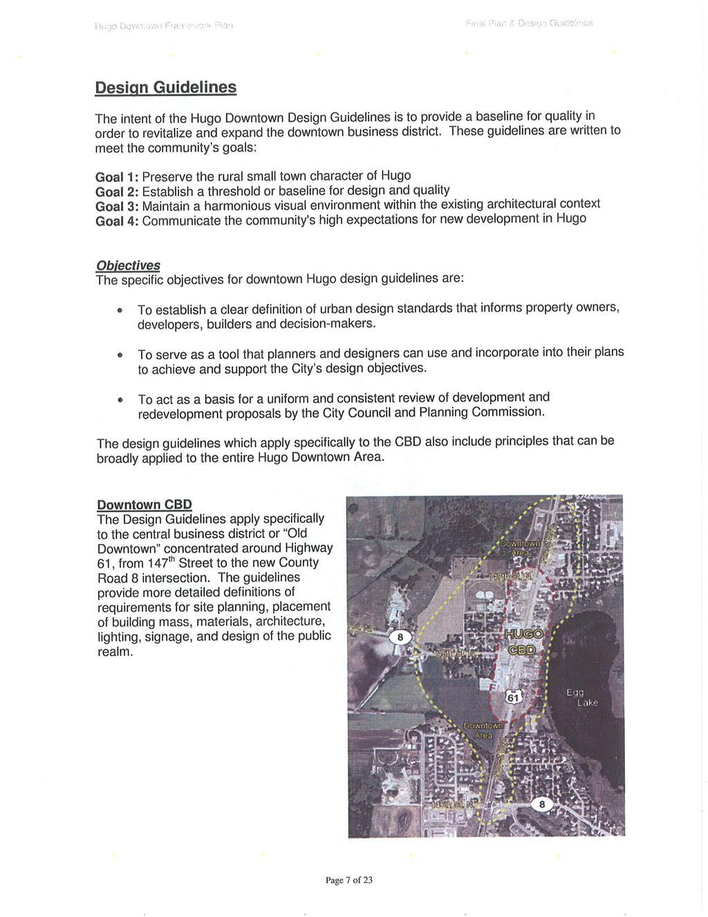
27 4.4. AREAS OF NEW OPPORTUNITY Downtown Plan On April 10, 2007, the City approved the Downtown Plan & Design Guidelines to provide direction for new development in downtown Hugo and to shape plans for redevelopment. This vision of future development in Hugo encourages commercial growth, while seeking to concentrate that growth around the downtown area. The Hugo downtown plan and preliminary design guidelines were originally developed in 1998 to address redevelopment of the downtown commercial Main Street on Forest Boulevard (Highway 61). But the County Road 8 improvements and rerouting required that the original plan be revisited. The new plan was needed to address the developable area along County Road 8 and to consider the impact of the new County Road 8 and Highway 61 intersection. This planning process began in the fall of 2003 and included workshops with the City Council and downtown business and property owners. A community-wide open house was held in May 2004 to encourage public input on the final plan. In August 2004, the City was awarded an Opportunity Grant from the Metropolitan Council Livable Communities Demonstration Account to develop design guidelines for the downtown area to assist in implementation of the downtown plan. The process for developing these guidelines continued through with significant public participation in the planning process prior to approval of the plan in This area is shown as Mixed Use on the 2030 Plan and the City of Hugo expects development to occur in this area in compliance with the Downtown Plan & Design Guidelines ( see Map 7-B -- Downtown Plan). Mixed Use In addition to the Mixed Use area in Downtown Hugo, the City has identified 2 additional mixed use areas: Near the intersection of Elmcrest Avenue and 170 th Street. Near the intersection of Highway 61 and 170 th Street. We expect that these areas will include a mix of residential and commercial uses, but some business park uses may also be permitted. These mixed use areas are in highly visible areas of the City and, consequently, development in these gateway areas will be expected to provide a higher level of site design and architectural design than in other areas of the city. As part of the implementation plan, the City should conduct more detailed studies that will establish the design standard for these areas. Chapter
28 4.5. GROWTH MANAGEMENT PLAN The City of Hugo seeks to promote a more efficient use of land in order to allow the City to balance the demand for urban services and the ability of the City to provide those services in a fiscally and environmentally responsible manner. The Case for Growth Management in Hugo The City of Hugo has experienced rapid growth in the last 10 years. The public s perception is that growth is too fast and that the quality of life, development, and the environment are being threatened. New development is planned on the east side of the City near I-35E and Highway 61. This is the area where municipal utilities are most easily extended, due to the location of the Forest Lake Sewer Interceptor and the existing municipal utility system. Growth in this area is consistent with the extension of the utility and transportation systems to serve this growth. The City still has a significant amount of land, which is farmed, mostly in the eastern half of the City. While agriculture may be an interim use of the land in some areas, the growth management plan will allow orderly growth at levels that will allow agricultural operations to continue for a longer period of time. However, the changing nature of agricultural operations may mean that agriculture, as a primary use of the land, will not have a long-term future in the City of Hugo. Growth Management Goals The following are the City s goals for growth management: 1. To accommodate growth at a level that allows for the careful planning and preservation of valuable natural resources and rural character and to manage the transition from rural to urban development. 2. To accommodate the extension of urban services in such a manner that would facilitate this type of planned growth. 3. To maintain a level of growth that is consistent with the City s ability to cost-effectively provide services for future development in a timely manner. 4. To maintain efficient, cost-effective and organized land development patterns. Chapter
29 5. To accommodate a reasonable and rational amount of development consistent with the region s need to grow while preserving the balance of supply and demand. Growth Management Policies It is the City s growth management policy to: 1. Construct trunk utilities within the 2030 MUSA to accommodate an average of approximately 428 new residential units per year. The City will use a rolling average over 5 year increments so that a lower level of development may occur in some years and a higher level in other years, provided the average annual residential permits does not exceed 428 units per year. 2. Expand MUSA in a manner that promotes orderly, contiguous and sequential growth. Leapfrog development past parcels that are located in the 2030 MUSA, but to which utilities have not yet been extended, will be discouraged. 3. Develop infrastructure assessment policies that ensure that development is not encouraged by levying of assessments against properties that are not yet ready for development. 4. Require a staging plan for all new developments so that infrastructure within a given phase can be staged. 5. Limit total rural development in areas beyond the 2030 MUSA to one unit per 10 acres or less density. 6. Limit future development in areas located within the 2030 MUSA, but not serviced by public utilities, to one unit per 20 acres or less density except for lots of record. This will allow preservation of land in parcels large enough to ensure opportunities for future development. Growth Management Approach Establish Growth Management policies that require the following growth management approach: Manage the allocation of residential units on a yearly basis, but averaged over a 5 year period, to ensure land supply is not prematurely depleted and to ensure, wherever possible, even growth from year to year. Spread area assessments only to lands that are imminently developable within the 2030 MUSA. Chapter
30 Growth Management and Housing Affordability It is important to acknowledge that because the supply of developable land may become more limited while demand remains strong and the costs to develop land become higher, the result may be higher housing costs, making affordable housing more difficult to provide. In order to combat this unintended and undesirable outcome, the City may need to take steps to ensure that a reasonable proportion of the new housing stock is affordable in keeping with the mandates of the Metropolitan Council (See Chapter 5 - Housing Plan). Chapter
31 APPENDIX 4-A Comprehensive Plan Amendment Process Chapter
32 This page intentionally left blank. Chapter
33 Comprehensive Plan Amendment Process A. AMENDMENTS INITIATED BY APPLICANTS OTHER THAN THE CITY OF HUGO 1. Request for an amendment to any portion of the Comprehensive Plan (text or maps) shall be filed with the Community Development Director on an official application form. Such application shall be accompanied by a fee as set forth in the City Code. Such application shall also be accompanied by detailed written and graphic materials, the number and size as prescribed by the Community Development Director, fully explaining the proposed change to the plan, along with a list of property owners located within 350 feet of any subject property in a format prescribed by the City. The application shall be considered as being officially submitted and complete when the applicant has complied with all the specified information requirements. 2. Within 15 days of receipt of a complete application for a change to the 2030 Plan Map of the Comprehensive Plan, the Community Development Director shall cause a notice to be mailed to all owners of land within 350 feet of the boundary of the property in question, informing them of the receipt of the application and the anticipated schedule for consideration of the amendment. 3. Upon receipt of a complete application for any type of amendment and following staff analysis of the application and request, the Community Development Director shall set a public hearing following proper hearing notification. The Planning Commission shall conduct the hearing and report its findings and make recommendations to the City Council. Notice of said hearing shall be published in the official newspaper at least ten (10) days prior to the hearing and when the amendment affects a particular property, written notification of said hearing shall be mailed at least ten (10) days prior to landowners within 350 feet of the boundary of the property in question. Failure of a property owner to receive said notice shall not invalidate any such proceedings as set forth within this policy. 4. The Planning Commission shall review the impact of the proposed amendment. Its judgment shall be based upon (but not limited to) the following factors: a. The extent to which the locational criteria of applicable existing or proposed land use plan classifications are satisfied. b. Evidence submitted by the applicant demonstrating the reason(s) that the plan should be changed, including but not limited to whether new information has become available since the Comprehensive Plan was adopted that supports re-examination of the plan, or that existing or Chapter
34 proposed development offers new opportunities or constraints that were not previously considered by the Plan. c. If the amendment affects a particular site, whether or not the change is needed to allow reasonable development of the site. d. The relationship of the proposed amendment to the supply and demand for particular land uses within the city and the immediate vicinity of the site. e. A demonstration by the applicant that the proposed amendment has merit beyond the interests of the proponent. f. The possible impacts of the amendment on all specific elements of the Comprehensive Plan as may be applicable, including but not limited to: Transportation, as demonstrated by a traffic study to be conducted by the City at the expense of the applicant; Sanitary sewer, including existing and proposed sanitary sewer flows as compared to the adopted plan; Housing, including the extent to which the proposal contributes to the City's adopted housing goals; Surface water, including compliance with the City's goals for water quality as well as water quantity management; Water supply; Parks and open space; and Capital improvement program (CIP). g. Consideration of the impact of the proposed amendment upon current and future special assessments and utility area charges, future property tax assessments or other fiscal impacts upon the City of Hugo. 5. The City may request additional information from the applicant concerning the requested amendment or retain expert testimony with the consent and at the expense of the applicant, said information to be declared necessary to establish the possible effects or benefits of the proposed Comprehensive Plan amendment. 6. The applicant or a representative thereof may appear before the Planning Commission in order to present information and answer questions concerning the proposed request. 7. The Planning Commission shall make a recommendation on the request. Such recommendations shall be accompanied by the report and recommendation of the City staff. 8. The City Council shall not act upon an amendment until they have received a report and recommendation from the Planning Commission and the City staff or until sixty (60) days after the first regular Planning Commission meeting at which the request was considered. Chapter
35 9. Upon receiving the report and recommendation of the Planning Commission and the City staff, the City Administrator shall schedule the application for consideration by the City Council. Such reports and recommendations shall be entered in and made part of the permanent written record of the City Council meeting. 10. Approval of a proposed amendment shall require passage by a two-thirds (2/3) vote of the entire City Council. 11. The City Council may approve an amendment conditionally upon completion of any review by the Metropolitan Council pursuant to the Metropolitan Planning Act. Or, the City Council may direct staff to submit the amendment recommended by the Planning Commission to the Metropolitan Council for review prior to City Council consideration of the amendment and consider final passage of the amendment only after completion of the Metropolitan Council's review. 12. Whenever an application for an amendment has been considered and denied by the City Council, a similar application for an amendment affecting substantially the same property shall not be considered again by the Planning Commission or City Council for at least six (6) months from the date of its denial; and a subsequent application affecting substantially the same property shall likewise not be considered again by the Planning Commission or City Council for an additional six (6) months from the date of the second denial unless a decision to reconsider such matter is made by a majority of the full City Council. 13. Amendment applications shall be approved or denied within one hundred and twenty (120) days from the date of official and complete submission unless extended by a mutual agreement between the applicant and the City Council. B. AMENDMENTS INITIATED BY THE CITY COUNCIL OR PLANNING COMMISSION The City Council or Planning Commission may initiate amendments to the text or maps of the Comprehensive Plan. The procedural requirements of Section A., above, shall apply to such proposed amendments to the extent required by State Statute and as follows: 1. Plan Amendments Affecting Forty (40) Acres or Less a. Upon initiation of an amendment to the 2030 Plan Map of the Comprehensive Plan that may affect a particular land area of forty (40) acres or less, the Community Development Director shall cause a notice to be mailed to all owners of land within 350 feet of the boundary of the property in question, informing them of the initiation of Chapter
36 the amendment and the anticipated schedule for consideration of the amendment. b. Following staff analysis of the application and request, the Community Development Director shall set a public hearing following proper hearing notification. The Planning Commission shall conduct the public hearing. Notice of said hearing shall be published in the official newspaper at least ten (10) days prior to the hearing and written notification of said hearing shall be mailed at least ten (10) days prior to all owners of land 350 feet of the boundary of the property in question. Failure of a property owner to receive said notice shall not invalidate any such proceedings as set forth within this policy. Following the hearing the Planning Commission shall report its findings and make recommendations to the City Council. Such recommendations shall be accompanied by the report and recommendation of the City staff. c. A proposed amendment to the Comprehensive Plan that effects a particular land area of forty (40) acres or less shall be approved or denied within one hundred twenty (120) days from the date of its initiation unless this review period is extended by the Planning Commission or City Council, depending upon which body initiated the amendment. 2. All Other Comprehensive Plan Amendments a. The Planning Commission or City Council, upon initiating the amendment, shall specify the notification procedure to be followed to ensure that all affected citizens and landowners will have adequate notice of the initiation and consideration of said amendment. b. The Planning Commission or City Council, upon initiating the amendment, shall specify the anticipated schedule for consideration of the amendment. Chapter
37 APPENDIX 4-B Downtown Plan & Design Guidelines Chapter
38 This page intentionally left blank. Chapter
39
40
41
42
43
44
45
46
47
48
49
50
51
52
53
54
55
56
57
58
59
60
61
62

63 GREYSTONE INGERSOLL KEYSTONE KEYSTONE ELMCREST GARDEN ELMCREST EVERTON FRENCHMAN VICTOR 129TH 158TH HERITAGE VALJEAN ETHAN Bald Eagle FABLE HILL EVERTON ONEKA ELM 126TH EUROPA 122ND FAIROAKS 149TH EUROPA EXHALL 121ST FALCON FARNHAM ONEKA 180TH FENWAY FRENCH FARNHAM 174TH FARNHAM FENWAY FREEDOM FINALE 159TH FINLEY 142ND FENWAY 134TH 130TH FIONA FOREST 141ST 140TH 138TH FIONA 142ND FIONA 157TH 147TH 129TH FLAY FOXHILL 150TH 126TH 152ND 148TH 147TH Egg FOXHILL GENEVA GENEVA EGG LAKE 135TH FOREST 151ST 150TH 145TH GOODVIEW 177TH 150TH 175TH 152ND 130TH 132ND 165TH Oneka HADLEY 177TH Horseshoe Rice ONEKA LAKE HARROW 137TH 125TH HEATHER HENNA INWOOD 157TH 128TH HILO 180TH HOMESTEAD HYDE HOMESTEAD ILLIES INGERSOLL 147TH 140TH 155TH IRISH IRISH 136TH 126TH ISLETON IVAN ISLETON 180TH Proposed 2030 MUSA Boundary Sunset INGERSOLL Round Long JANERO JEFFREY 152ND 130TH 125TH 170TH Plaisted North School Section JODY 122ND JULY KELLER 180TH KERRY KEYSTONE KEYSTONE KEYSTONE Barker South School Section PLANNED LAND USE Agricultural (AG) Large Lot Residential (LL) Very Low Density (VLD) Low Density Residential - (LD) Medium Density Residential (MD) High Density Residential (HD) Business Park (BP) Commercial (COM) Industrial (IND) Mixed Use (MIX Public/Quasi-Public (PQ) Proposed 2030 MUSA Boundary Major_Roads Parcel_Boundary Sewer Interceptor Miles City of Hugo March 15, Plan Map 4-A

64 Downtown Plan Map 4-B - Map created for the purpose of discussion only. City of Hugo March 15, 2010
4. Shape Transitions. 4. Shape Transitions
 4. Shape Transitions 49 Zoning District Policies Overall Intent: Maintain neighborhood character by creating compatible transitions that minimize land use conflicts. Strategy: Define the character of zoning
Gold Line Bus Rapid Transit Transit Oriented Development (BRTOD) Helmo Station Area Plan
 Helmo Station Area Plan") Appendix F Gold Line Bus Rapid Transit Transit Oriented Development (BRTOD) Helmo Station Area Plan Introduction and Purpose of the Plan The Gold Line Bus Rapid Transit facility is an eleven-mile dedicated
Appendix F Gold Line Bus Rapid Transit Transit Oriented Development (BRTOD) Helmo Station Area Plan Introduction and Purpose of the Plan The Gold Line Bus Rapid Transit facility is an eleven-mile dedicated
E. RURAL COMMERCIAL/INDUSTRIAL PARK MODEL
 E. RURAL COMMERCIAL/INDUSTRIAL PARK MODEL 1. PURPOSE The purpose of the Rural Commerce/Industrial Park Model is to provide parameters within which a grouping of business buildings with parking, loading
NEW CASTLE COUNTY S ZONING DISTRICTS
 NEW CASTLE COUNTY S ZONING DISTRICTS This is general information about New Castle County s zoning districts. The information included is by no means exhaustive or complete. Before designing plans to develop
General Location Annex, Rezone & Preliminary Plat Lansdowne Addition, Unit Three
 NEWFOUNDLAND I-5 Agricultural District Subject Site SUNDANCE ANDERSON Single Family Residential CHRISTY PUD Agricultural District Highway Business General Location Annex, Rezone & Preliminary Plat Lansdowne
Draft CHAPTER TWO THREE LAND USE PLAN
 CHAPTER TWO THREE LAND USE PLAN LAND USE PLAN The basic intent of the comprehensive planning process is to provide a well-founded and coordinated decision-making framework to guide both public and private
2.0 AREA PLANS. Lakeside Business District. Lakeside Business District Land Use Categories:
 Lakeside Business District Lakeside Business District Land Use Categories: Campus Commercial Campus Commercial means a mixture of uses which includes corporate offices, office parks, hotels, commercial,
Planned Residential Neighborhoods Land Use Goals
 Planned Residential Neighborhoods Land Use Goals Issue: Guidelines that provide for diverse high quality residential areas that include a variety of housing styles and layouts are needed. Goal 1: Create
LAND USE ELEMENT. Purpose. General Goals & Policies
 LAND USE ELEMENT Purpose This Land Use Element contains the goals and policies necessary to support the City s responsibility for managing land resources and guiding development through implementing regulations,
TABLE 5-1 EXISTING LAND USES (2016)
") Chapter 5: LAND USE & GROWTH Introduction Medina has significant natural resources, high-quality neighborhoods and areas for commercial and retail development. The City s extensive wetlands and limited
Chapter 5: LAND USE & GROWTH Introduction Medina has significant natural resources, high-quality neighborhoods and areas for commercial and retail development. The City s extensive wetlands and limited
3.10 LAND USE SETTING PROJECT SITE EXISTING LAND USE DESIGNATIONS AND ZONING. General Plan Land Use Designations.
 This section of the Draft EIR addresses the existing land uses on and adjacent to the project site and discusses the potential impacts of the proposed project on existing land uses. Key issues addressed
PLANNED UNIT DEVELOPMENT Date: April 5, 2018
 PLANNED UNIT DEVELOPMENT Date: April 5, 2018 DEVELOPMENT NAME SUBDIVISION NAME LOCATION Robert Myers Robert Myers 2955 and 2989 Dauphin Street (Southeast corner of Dauphin Street and Sage Avenue) CITY
AWH REPORT OF THE PLANNING AND DEVELOPMENT DEPARTMENT FOR APPLICATION FOR REZONING ORDINANCE TO PLANNED UNIT DEVELOPMENT
 AWH REPORT OF THE PLANNING AND DEVELOPMENT DEPARTMENT FOR APPLICATION FOR REZONING ORDINANCE TO PLANNED UNIT DEVELOPMENT MAY 8, 2014 The Planning and Development Department hereby forwards to the Planning
DEVELOPMENT FRAMEWORK POST 2030 LAND USE PLAN INTRODUCTION
 INTRODUCTION Oak Grove s Comprehensive Plan identifies a future Metropolitan Urban Service Area (MUSA). The Metropolitan Council does not anticipate extending utilities to this area prior to 2030. The
To ensure that resources will be available to provide a consistent level of public services to the community.
 Future Land Use Plan The land use plan is one of the most prominent chapters in the Stillwater Comprehensive Plan. It provides a visual representation of what the community is expected to look like in
4. INDUSTRIAL 53 CASTLE ROCK DESIGN
 4. INDUSTRIAL 53 CASTLE ROCK DESIGN CASTLE ROCK DESIGN 54 4. INDUSTRIAL Overview Well-designed and attractive industrial centers are the product of blending economic realities with both functional and
Secrest Short Cut and Monroe Expressway Small Area Plan AUGUST 29, 2018
 Secrest Short Cut and Monroe Expressway Small Area Plan AUGUST 29, 2018 Background and Process Monroe Expressway will be open by the end of 2018 Union County and Indian Trail identified a need to revisit
COMMUNITY DESIGN. GOAL: Create livable and attractive communities. Intent
 COMMUNITY DESIGN Intent An attractive, well-designed County will attract quality development, instill civic pride, improve the visual character of the community, and create a strong, positive image for
This chapter describes the purpose of the Plan, introduces how the Plan is organized and provides contextual background for the Plan.
 Chapter 1: INTRODUCTION Purpose of a Comprehensive Plan The 2040 Comprehensive Plan establishes Medina s vision as a community and sets goals and objectives which guide future decisions and policies. The
SECTION UNIFIED DEVELOPMENT ORDINANCE SECTION Part 1 Ordinance. ARTICLE 1 Zoning Districts
 SECTION 1-100 UNIFIED DEVELOPMENT ORDINANCE SECTION 1-300 Part 1 Ordinance SECTION 1-100. Introduction. ARTICLE 1 Zoning Districts Crystal Lake strives to maintain a balance of various land uses for a
Baumgarten MPUD. Exhibit 3 Evaluation Criteria
 Pursuant to LDC subsections 10.02.13 B, 10.02.08 F and Chapter 3 G. of the Administrative Code, staff s analysis and recommendation to the Planning Commission, and the Planning Commission s recommendation
and services The protection and conservation of environmentally significant and sensitive natural heritage features and functions.
 6. Land Use 6.0 Preamble A healthy and livable city is one in which people can enjoy a vibrant economy and a sustainable healthy environment in safe, caring and diverse neighbourhoods. In order to ensure
Policies and Code Intent Sections Related to Town Center
 Policies and Code Intent Sections Related to Town Center The Town Center Vision is scattered throughout the Comprehensive Plan, development code and the 1994 Town Center Plan. What follows are sections
Staff Report and Recommendation
 Community Planning and Development Planning Services 201 W. Colfax Ave., Dept. 205 Denver, CO 80202 p: 720.865.2915 f: 720.865.3052 www.denvergov.org/cpd TO: City Council Neighborhoods and Planning Committee
LAND USE OVERVIEW WHAT YOU WILL FIND IN THIS CHAPTER
 LAND USE WHAT YOU WILL FIND IN THIS CHAPTER Information about the City s expected population and employment growth. Description and capacity of existing and future land use designations. Policies that
4.1.3 LAND USE CATEGORIES
 4.1.3 LAND USE CATEGORIES a. City Center District The City Center District incorporates the existing character and mix of uses in downtown Belmont to encourage redevelopment and new development in keeping
9 th Street Sub Area Plan
 9 th Street Sub Area Plan In the 1990 s, when the Township prepared the last Master Plan, the 9 th Street corridor was studied as part of a larger 9 th Street Focus Area that included the West Main Street
POLICIES & REGULATIONS
 POLICIES & REGULATIONS Land use planning is now heavily regulated in certain counties of Washington State because of past rapid growth. The most significant change brought about by the Washington State
ALBEMARLE COUNTY CODE CHAPTER 18 ZONING SECTION 20A NEIGHBORHOOD MODEL - NMD
 CHAPTER 18 ZONING SECTION 20A NEIGHBORHOOD MODEL - NMD Sections: 20A.1 PURPOSE AND INTENT 20A.2 STATUS AS A PLANNED DEVELOPMENT DISTRICT 20A.5 CODES OF DEVELOPMENT 20A.6 PERMITTED USES 20A.7 RESIDENTIAL
DEVELOPMENT FRAMEWORK 2030 LAND USE PLAN INTRODUCTION
 INTRODUCTION The Oak Grove Land Use Plan anticipates two stages of community development. The first stage of development (28-23) promotes very low density rural growth patterns characterized by large lots,
6.0 Land Use Policies for Rural Settlements. 6.1 Rural Settlement Strategy
 6.0 Land Use Policies for Rural Settlements 6.1 Rural Settlement Strategy INTRODUCTION AMENDMENT NO. 131 PURPOSE Designated rural settlements comprise Rural Clusters, Villages and Serviced Villages as
Improve Neighborhood Design and Reduce Non Point Source Water Pollution
 HOW TO Planning Guide Improve Neighborhood Design and Reduce Non Point Source Water Pollution This document was funded by a grant from the New Hampshire Coastal Program with funding from the National Oceanic
REPORT OF THE PLANNING AND DEVELOPMENT DEPARTMENT FOR APPLICATION FOR REZONING ORDINANCE TO PLANNED UNIT DEVELOPMENT AUGUST 18, 2016
 REPORT OF THE PLANNING AND DEVELOPMENT DEPARTMENT FOR APPLICATION FOR REZONING ORDINANCE TO PLANNED UNIT DEVELOPMENT AUGUST 18, 2016 AWH The Planning and Development Department hereby forwards to the Planning
Planning & Zoning Commission Staff Report
 Planning & Zoning Commission Staff Report Meeting Date: May 26, 2015 Drafted by: Katherine Harrison-Rogers CASE # Z2886 PROJECT NAME: APPLICANT/ REPRESENTATIVE: Shawna Runyan PROPERTY OWNER: 1840 (previously
A citizen s guide to the. Comprehensive Plan. City of Lakeville, Minnesota 1
 A citizen s guide to the Comprehensive Plan 2008 City of Lakeville, Minnesota 1 Introduction The City of Lakeville completed an update of its Comprehensive Plan in 2008. A comprehensive plan is a tool
McDonald s Restaurant - Purcellville Town of Purcellville Special Use Permit Statement of Justification July 24, 2014
 Introduction / Written Statement McDonald s Restaurant - Purcellville McDonald s Corporation is proposing to redevelop the existing McDonald s eating establishment with a drive-through located at 121 N
Official Plan Review
 Official Plan Review Summary Report - The Built Environment August 2014 Part 1: Introduction Planning for a healthy, prosperous and sustainable community is an important goal for our municipality. From
17.11 Establishment of Land Use Districts
 17.11 Establishment of Land Use Districts 17.11.010 Purpose. To promote the health, safety, and general welfare of City residents and those who come to South Salt Lake to work, exchange commerce and recreate.
WORK SESSION STAFF REPORT Work Session Item No. 2. Michael Grochala, Community Development Director
 WORK SESSION STAFF REPORT Work Session Item No. 2 WS Item 2 Date: March, 2018 To: From: Re: City Council Michael Grochala, Community Development Director 200 Comprehensive Plan Mixed Use Districts Background
CONTENTS 8.0 LAND USE 8.1 GENERAL LAND USE 8.2 RESIDENTIAL 8.3 MIXED USE 8.4 COMMERCIAL 8.5 EMPLOYMENT LANDS
 8-2 Land Use 8.0 LAND USE CONTENTS 8.1 GENERAL LAND USE 8.1.1 Uses provided for in all Land Use Designations 8.1.2 Uses prohibited in Hazardous Lands, Hazardous Sites and Special Policy Areas 8.1.3 Uses
Staff Report to the North Ogden City Planning Commission
 Staff Report to the North Ogden City Planning Commission SYNOPSIS / APPLICATION INFORMATION Application Request: Concept review on a legislative application to rezone land located at approximately 1750
IMPLEMENTATION STRATEGIES. In This Chapter. Goals & Strategies 182 Project List 183 Future Land Use 186 CHAPTER 11 IMPLEMENTATION STRATEGIES
 In This Chapter Goals & Strategies 182 Project List 183 Future Land Use 186 11 IMPLEMENTATION STRATEGIES NORTH AUGUSTA, SC 2017 COMPREHENSIVE PLAN 179 Individual commitment to a group effort that is what
8 Future Land Use Plan
 The Plan provides a land use framework for future development in the county through 2020. Future Land Use Plan The Future Land Use Plan provides a land use framework for future development in the county
Section 9 NEIGHBORHOOD DESIGN
 Section 9 NEIGHBORHOOD DESIGN City of Lancaster Comprehensive Plan D u n k i n, S e f k o & A s s o c i a t e s, I n c. NEIGHBORHOOD DESIGN INTRODUCTION There are many ways in which a neighborhood can
CITY OF PUYALLUP. Background. Development Services
 CITY OF PUYALLUP Development Services 333 South Meridian Puyallup WA 98371 To: City Council From: Katie Baker, AICP, Planning Division Re: South Hill Neighborhood Plan Adoption Date: (Meeting date: February
PORT WHITBY COMMUNITY
 PORT WHITBY COMMUNITY SECONDARY PLAN UPDATE COMMUNITY IMPROVEMENT PLAN URBAN DESIGN GUIDELINES September 2015 DRAFT PROPOSED AMENDMENT NUMBER # to the Whitby Official Plan PURPOSE: The intent of this Amendment
A. WHAT IS A GENERAL PLAN?
 I. Introduction A. WHAT IS A GENERAL PLAN? A general plan is the planning guideline for the future of a city. It contains goals and policies which regulate urban development, the protection of the natural
CHAPTER 7: VISION AND ACTION STATEMENTS. Noble 2025 Vision Statement
 CHAPTER 7: VISION AND ACTION STATEMENTS This chapter presents the vision, policy and action statements that transform the comprehensive planning study, an analysis of Noble s past, future trends and community
1. FUTURE LAND USE ELEMENT Goals, Objectives, and Policies
 1. Goals, Objectives, and Policies The has limited vacant land remaining for new development. Redevelopment is anticipated to represent nearly all development activity within the City. More City residents
Town of Portola Valley General Plan. Nathhorst Triangle Area Plan
 Town of Portola Valley General Plan Amended December 10, 1997 Table of Contents Introduction... 1 Planning Area... 1 Objectives... 2 Principles... 2 Standards... 4 Description... 4 Community Commercial...
ARTICLE 6: Special and Planned Development Districts
 ARTICLE 6: Special and Planned Development Districts 6-10 Traditional Neighborhood Development (TND) District 6-10.10 Purpose and Intent The Traditional Neighborhood Development (TND) District provides
LAND USE CATEGORIES. City of Sparks Comprehensive Plan Chapter Two: Pathway to the Future - Draft 1
 LAND USE CATEGORIES The following tables summarize the land use categories identified on the Map, describing the s designation shown on the Map. The tables summarize the primary uses and other uses, residential
SECTION II SECTION II STATEMENT OF GOALS, OBJECTIVES, PRINCIPLES, ASSUMPTIONS, POLICIES AND STANDARDS
 STATEMENT OF GOALS, OBJECTIVES, PRINCIPLES, ASSUMPTIONS, POLICIES AND STANDARDS 1 2 STATEMENT OF GOALS, OBJECTIVES, PRINCIPLES, ASSUMPTIONS, POLICIES AND STANDARDS INTRODUCTION The New Jersey Municipal
CHAPTER 21 NC-PUD NEIGHBORHOOD COMMERCIAL PUD DISTRICT
 CHAPTER 21 NC-PUD NEIGHBORHOOD COMMERCIAL PUD DISTRICT Section 21.1. Title and Purpose. The Neighborhood Commercial Planned Unit Development District, designated the, is intended for commercial uses of
Watertown City Council
 City of Watertown Watertown City Council April 14 th, 2015 Agenda Item: City Comment on Sun Share CUP Application Request for Action: Motion to Approve City Comments regarding CUP Application Department:
Chapter 10 IMPLEMENTATION RECOMMENDATIONS
 Chapter 10 IMPLEMENTATION RECOMMENDATIONS The recommended land use plan presented in the previous chapter provides a design for the attainment of the urban and rural development and open space preservation
Woodburn Comprehensive Plan Growth Management Goals and Policies
 Goal Woodburn Comprehensive Plan Growth Management Goals and Policies G-1. The City's goal is to manage growth in a balanced, orderly and efficient manner, consistent with the City s coordinated population
Exhibit A. 8:9 Scuffletown Rural Conservation District
 Exhibit A 8:9 Scuffletown Rural Conservation District 8:9.1 Intent and Purpose The Scuffletown Rural Conservation (SRC) District is intended to provide for residential development that supports the development
ROAD CLOSURE AND LAND USE AMENDMENT SILVER SPRINGS (WARD 1) NORTHEAST OF NOSEHILL DRIVE NW AND SILVER SPRINGS ROAD NW BYLAWS 2C2018 AND 29D2018
 NORTHEAST OF NOSEHILL DRIVE NW AND SILVER SPRINGS ROAD NW BYLAWS 2C2018 AND 29D2018") Page 1 of 19 EXECUTIVE SUMMARY This application proposes redesignating two parcels in the community of Silver Springs from Special Purpose Future Urban Development (S-FUD) District and undesignated road
Page 1 of 19 EXECUTIVE SUMMARY This application proposes redesignating two parcels in the community of Silver Springs from Special Purpose Future Urban Development (S-FUD) District and undesignated road
Dwelling Units Max 12 dwelling units per acre/min 8 dwelling units per acre. Development Mix 80% non residential/20% residential
 13. OSTEEN LOCAL PLAN Background: The Osteen Local Plan area is located in southwest Volusia County along the SR 415 corridor between Lemon Bluff Road and Acorn Lake Road and includes 3,990 acres. The
LAND USE CATEGORIES. City of Sparks Comprehensive Plan Land Use Categories - Draft
 LAND USE CATEGORIES The following tables summarize the land use categories identified on the Map, describing the s designation shown on the Map. The tables summarize the primary uses and other uses, residential
EXHIBIT B PROJECT NARRATIVE POULSBO MEADOWS
 EXHIBIT B PROJECT NARRATIVE POULSBO MEADOWS Name of Project: Poulsbo Meadows; A Planned Residential Development (PRD)/Plat Applicants Name: PBH Group LLC/Byron Harris PO Box 1010 Silverdale, WA 98038 Description
Ten Mile Creek Planning Area
 PLANNING AREA POLICIES TEN MILE CREEK Ten Mile Creek Planning Area Location and Context The Ten Mile Creek Planning Area ( Ten Mile Creek area ) is located south of the current Boise AOCI, generally south
CHUGIAK-EAGLE RIVER SITE-SPECIFIC LAND USE PLAN
 CHUGIAK-EAGLE RIVER SITE-SPECIFIC LAND USE PLAN JUNE 2010 Final Prepared for The Heritage Land Bank, Municipality of Anchorage by Agnew: :Beck Consulting www.agnewbeck.com 907.222.5424 Chugiak-Eagle River
4 RESIDENTIAL ZONE. 4.1 Background
 4 RESIDENTIAL ZONE 4.1 Background The residential areas within the City are characterised by mainly lowrise dwellings sited on individual allotments. Past architectural styles, settlement patterns and
CHAPTER 4 - LAND USE CLASSIFICATIONS
 CHAPTER 4 - LAND USE CLASSIFICATIONS Four new land use classification categories are established in the Gualala Town Plan: Gualala Village Mixed Use; Gualala Highway Mixed Use; Gualala Planned Development
EXECUTIVE SUMMARY DRAFT CHAPTER 1 INTRODUCTION EXECUTIVE SUMMARY
 CHAPTER 1 EXECUTIVE SUMMARY INTRODUCTION Through the joint efforts of the City of Tulsa planning staff and the Land Services division of Indian Nations Council of Governments (INCOG), the Berryhill Land
Urban Design Brief Fanshawe Park Road. Competition Toyota
 Urban Design Brief 1300 Fanshawe Park Road Competition Toyota May 2, 2014 TABLE OF CONTENTS Page No. INTRODUCTION... 1 SECTION 1 LAND USE PLANNING CONTEXT... 1 1.1 The Subject Lands... 1 1.2 The Proposal...
Section 3: Land Use M C H E N R Y K A N E. Figure 3.1: Potential Future Municipal Boundaries. Future Municipal Boundaries. County Land Use Plans
 Section 3: Land Use Figure 3.1: Potential Future Municipal Boundaries Land use and transportation are intertwined; yet, land use and transpor- tation planning are often undertaken as separate disciplines.
Planning Commission April 4, 2013 BOCC Workshop Page 1
 Planning Commission April 4, 2013 BOCC Workshop Page 1 Planning Commission April 4, 2013 BOCC Workshop Page 2 Planning Commission April 4, 2013 BOCC Workshop Page 3 Planning Commission April 4, 2013 BOCC
2018 Northampton Township Comprehensive Plan
 2018 BUCKS COUNTY, PENNSYLVANIA What is a? A comprehensive plan is a municipality s main policy document that details the collective vision for the future, the historic, environmental, and cultural facilities
6 PORT SYDNEY SETTLEMENT AREA
 Section 6 Port Sydney Page 61 6 PORT SYDNEY SETTLEMENT AREA 6.1 Basis and Principles Village of Port Sydney Waterfront Community Existing Services 6.1.1 Port Sydney is an historic settlement that has developed
B L A C K D I A M O N D D E S I G N G U I D E L I N E S for Multi-family Development
 B L A C K D I A M O N D D E S I G N G U I D E L I N E S for Multi-family Development Adopted June 18, 2009 This section of the Design and focuses on site planning and design guidance for new multi-family
City Of Sparks Planning Commission Item
 Page 1 of 12 City Of Sparks Planning Commission Item Meeting Date: May17, 2012 Subject: PCN12009, Public Hearing, Consideration and possible action on a Master Plan Amendment and Rezoning request to change
Vision Statement for the Town of Flower Mound Master Plan The Town of Flower Mound Master Plan furthers the established community based vision to:
 Vision Statement for the The furthers the established community based vision to: Preserve the country atmosphere and natural environment that makes Flower Mound a unique and desirable community; Mitigate
I539. Smales 2 Precinct
 I539. Smales 2 Precinct I539.1. Precinct Description The Smales 2 Precinct applies to a 4.8 hectare block of land located on the southern side of Northcote Road and fronting Lake Pupuke, Takapuna. The
Land Use Amendment in Southwood (Ward 11) at and Elbow Drive SW, LOC
 at and Elbow Drive SW, LOC") 2018 November 15 Page 1 of 10 EXECUTIVE SUMMARY This land use amendment application was submitted by Rick Balbi Architect on 2017 August 31 on behalf of Sable Developments Ltd, and with authorization from
2018 November 15 Page 1 of 10 EXECUTIVE SUMMARY This land use amendment application was submitted by Rick Balbi Architect on 2017 August 31 on behalf of Sable Developments Ltd, and with authorization from
YONGE STEELES CORRIDOR SECONDARY PLAN. Young + Wright / IBI Group Architects Dillon Consulting Ltd. GHK International (Canada) Ltd.
 Ltd.") PART A: PREAMBLE 1.0 PURPOSE The purpose of this Secondary Plan is to provide a development framework for intensification of the Yonge/ Steeles corridor including the north side of Steeles Avenue West
PART A: PREAMBLE 1.0 PURPOSE The purpose of this Secondary Plan is to provide a development framework for intensification of the Yonge/ Steeles corridor including the north side of Steeles Avenue West
Definitions. Average Daily Traffic Demand (ADT): The actual number or projected number of cars that pass a point in a 24-hour period.
: The actual number or projected number of cars that pass a point in a 24-hour period.") Definitions Access Management: A combination of physical techniques and transportation policies used to control the flow of traffic between roads and the surrounding lands. Alternative City Form Scenarios:
Definitions Access Management: A combination of physical techniques and transportation policies used to control the flow of traffic between roads and the surrounding lands. Alternative City Form Scenarios:
178 Carruthers Properties Inc.
 178 Carruthers Properties Inc. Planning Rationale for 178 Carruthers Avenue Site Plan Control Application June 2014 Table of Contents 1.0 Introduction 2.0 Overview of Subject Property 3.0 Current Zoning
Selected Area Study. Vision Plan Draft
 East Polk County Selected Area Study Draft 10.30.08 Contents Guiding Principles...4 Context Conclusions...5 Current Context...8 Scenarios...9 Scenario: Status Quo...10 Scenario: Connected & Directed Growth...12
CHAPTER 4 FUTURE LAND USE AND URBAN SERVICES DISTRICTS
 CHAPTER 4 FUTURE LAND USE AND URBAN SERVICES DISTRICTS Introduction This chapter discusses how Benzie County should grow and change in the future. A community can grow and change in many different ways.
Chapter 1 - General Design Guidelines CHAPTER 1 GENERAL DESIGN GUIDELINES
 CHAPTER 1 GENERAL DESIGN GUIDELINES 1.0 INTRODUCTION This Publication has been developed to provide current, uniform procedures and guidelines for the application and design of safe, convenient, efficient
FUTURE DEVELOPMENT AREAS
 FUTURE DEVELOPMENT AREAS Refer to the Future Development Map on Page 2. Suburban Residential (Less than 3 units/acre) Suburban Residential neighborhoods form the backbone of Smyrna. While growth and redevelopment
City of Yelm. Tahoma Terra Final Master Plan Development Guidelines. Table of Contents
 City of Yelm Tahoma Terra Final Master Plan Development Guidelines Table of Contents Table of Contents... 1 Purpose... 2 Low Density Residential (R4-6)... 3 Moderate Density Residential (R6-10)... 5 Neighborhood
3.5 Historic Old Town Character Area
 3.5 Historic Old Town Character Area Downtown Suwanee is characterized by two areas: Historic Old Town and Town Center. Due to their proximity and similar purposes, the two areas can function together
Asbury Chapel Subdivision Sketch Plan
 Asbury Chapel Subdivision Sketch Plan PART 1: PROJECT SUMMARY Applicant: NVR Inc. Project Size: +/- 76.13 acres Parcel Numbers: 02101112,02116101,02116112, 02116113 Current Zoning: Transitional Residential
Planned Development Review Revisions (Project No. PLNPCM )
") Planned Development Review Revisions (Project No. PLNPCM2014-00139) Standard residential development Planned Development Example: Smaller lot sizes than what is allowed to create open space amenity. What
Planned Development Review Revisions (Project No. PLNPCM2014-00139) Standard residential development Planned Development Example: Smaller lot sizes than what is allowed to create open space amenity. What
SOUTH NATOMAS COMMUNITY PLAN
 SOUTH NATOMAS Community Plan Part Three : COMMUNITY PLAN AREAS AND SPECIAL STUDY AREAS SACRAMENTO 2030 GENERAL PLAN Contents Community Location... 3-SN-3 Community Vision... 3-SN-4 Community Profile...
Be it enacted by the Town Board of the Town of Guilderland that the following new A (Transit Oriented Development (TOD) District) is adopted:
 District) is adopted:") Local Law No. 4 of 2018 (Adoption of 280-18A (Transit Oriented Development District) Be it enacted by the Town Board of the Town of Guilderland that the following new 280-18A (Transit Oriented Development
Local Law No. 4 of 2018 (Adoption of 280-18A (Transit Oriented Development District) Be it enacted by the Town Board of the Town of Guilderland that the following new 280-18A (Transit Oriented Development
PROTOTYPE DESIGN/INTRODUCTION
 PART III: PROTOTYPE DESIGN These concepts and guidelines described earlier were used to develop a prototype design for an emerging suburban area located west of the City of Milwaukee. This was done to
Chapter IV: Development Pattern
 Chapter IV: Development Pattern Introduction The 2002 Prince George s County Approved General Plan designates three growth policy tiers Developed, Developing, and Rural as well as three center designations
Port Lavaca Future Land Use
 Port Lavaca Future Land Use Introduction The City of Port Lavaca is beginning to see sustained growth, after many years of relative stable population. New single family homes, apartments, and businesses
Land Use. Chapter 8: Introduction. Land Use Vision. Section I: Current Land Use 8-1
 Introduction Land use is the defining element of the comprehensive plan. It will serve as a framework for decision makers, guiding future growth and development in the Town of Oconto Falls. This chapter
6 Growth Management Challenges and Opportunities
 6 Growth Management Challenges and Opportunities The Town has established a goal of attaining a 50% participation rate with respect to employment opportunities versus residential population. The Town s
[THIS PAGE INTENTIONALLY LEFT BLANK]
![[THIS PAGE INTENTIONALLY LEFT BLANK]](/thumbs/77/76526040.jpg "[THIS PAGE INTENTIONALLY LEFT BLANK]") 1-1 LAND USE [THIS PAGE INTENTIONALLY LEFT BLANK] TABLE OF CONTENTS INTRODUCTION... 7 1-1. GOAL: TO DEVELOP AND MAINTAIN A WELL-BALANCED COMMUNITY WITH A VARIETY OF LAND USES THAT ARE COMPATIBLE WITH EACH
1-1 LAND USE [THIS PAGE INTENTIONALLY LEFT BLANK] TABLE OF CONTENTS INTRODUCTION... 7 1-1. GOAL: TO DEVELOP AND MAINTAIN A WELL-BALANCED COMMUNITY WITH A VARIETY OF LAND USES THAT ARE COMPATIBLE WITH EACH
COMMISSION ACTION FORM
 ITEM #: 6 DATE: 10-18-17 COMMISSION ACTION FORM REQUEST: Public Hearing on Proposed Amendments to the Ames Urban Fringe Future Land Map and Land Use Policy Plan for the North Growth Gap Area BACKGROUND
[PLANNING RATIONALE] For Site Plan Control and Lifting of Holding Zone By-Law 101 Champagne Avenue. May 23, 2014
![[PLANNING RATIONALE] For Site Plan Control and Lifting of Holding Zone By-Law 101 Champagne Avenue. May 23, 2014](/thumbs/75/71599615.jpg "[PLANNING RATIONALE] For Site Plan Control and Lifting of Holding Zone By-Law 101 Champagne Avenue. May 23, 2014") [PLANNING RATIONALE] For Site Plan Control and Lifting of Holding Zone By-Law 101 Champagne Avenue May 23, 2014 Contents 1.0 Introduction... 2 2.0 Site Context... 2 2.1 Adjacent Uses... 2 Figure 1: Site
[PLANNING RATIONALE] For Site Plan Control and Lifting of Holding Zone By-Law 101 Champagne Avenue May 23, 2014 Contents 1.0 Introduction... 2 2.0 Site Context... 2 2.1 Adjacent Uses... 2 Figure 1: Site
VILLAGE OF CLEMMONS PLANNING BOARD DRAFT STAFF REPORT
 VILLAGE OF CLEMMONS PLANNING BOARD DRAFT STAFF REPORT PETITION INFORMATION Docket # C-226 Staff Megan Ledbetter Petitioner(s) JBJH Properties, LLC Owner(s) JBJH Properties, LLC Subject Property 5892-49-1766
Gloucester County s Comprehensive Plan. The Community Connection
 Gloucester County s Comprehensive Plan The Community Connection Current Comp Plan Adopted in 1991 with a 20 year planning horizon Updated in 1995 with Part V- Implementation Recommendations and Appendix