U.S. Army Corps of Engineers, Los Angeles District Prado Basin Project Updates
|
|
|
- Lenard Bishop
- 5 years ago
- Views:
Transcription
1 U.S. Army Corps of Engineers, Los Angeles District Prado Basin Project Updates Host: Inland Empire Utilities Agency January 19, :00 a.m. Purpose: To provide project overviews and updates to regional stakeholders for U.S. Army Corps of Engineers (USACE) projects within the Prado Dam Flood Control Basin, and to identify opportunities to improve project coordination. 1. Welcome and Self-Introductions Inland Empire Utilities Agency 2. Overview of USACE Roles & Responsibilities within Prado Basin Eileen Takata, USACE, Watershed Program Manager a. Land Ownership and Flood Risk Management b. Reservoir Regulations and Dam/Levee Safety c. Leased Lands and O&M d. CWA Section 404 (Regulatory) and Section 408 (Engineering) 3. Santa Ana River Mainstem (Flood Risk Management) Project Overview - Damien Lariviere, USACE, Project Manager 4. Prado Basin Feasibility Study Overview - Christopher Jones, USACE, Principal Biologist 5. Prado Dam Master Plan Update Overview Wendy Loeffler, RECON Environmental, Project Manager 6. Future Coordination Opportunities, Group Discussion Eileen T. 7. Adjourn
2 U.S. ARMY CORPS OF ENGINEERS PRADO BASIN ROLES & RESPONSIBILITIES BRIEF OVERVIEW 1 Eileen Takata, Watershed Program Manager Los Angeles District, Corps of Engineers 19 January 2017 File Name The views, opinions and findings contained in this report are those of the authors(s) and should not be construed as an official Department of the Army position, policy or decision, unless so designated by other official documentation.
3 ROLES & RESPONSIBILITIES IN PRADO BASIN Flood Risk Management Prado Dam Oper & Maint. (Asset Mgt/Ops) Reservoir Operations (Eng/H&H) Dam/Levee Safety (Eng/Geotechnical) Section 408 (Eng/Design) Santa Ana River Mainstem Project (Construction) Recreational & Other Land Use Leases (Asset Mgt) Environmental Stewardship NEPA (Asset Mgt) Section 404 (Regulatory) Mitigation/Restoration (Construction/Asset Mgt/Planning) Prado Basin (Ecosystem Restoration Feasibility Study (Planning) Cultural Resources (Planning) Restoration Proposals (Asset Mgt) Public Involvement/Collaboration (Planning)
4 LOS ANGELES DISTRICT SANTA ANA RIVER MAINSTEM PROJECT 3 Damien Lariviere, Senior Project Manager Los Angeles District, Corps of Engineers 19 January 2017 File Name The views, opinions and findings contained in this report are those of the authors(s) and should not be construed as an official Department of the Army position, policy or decision, unless so designated by other official documentation.


5 THE SANTA ANA RIVER MAINSTEM PROJECT SEVEN OAKS DAM PRADO DAM 4 LSAR MARSH


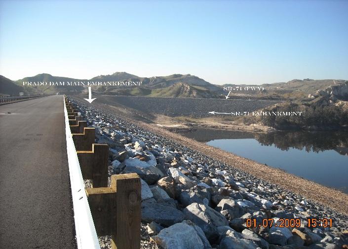
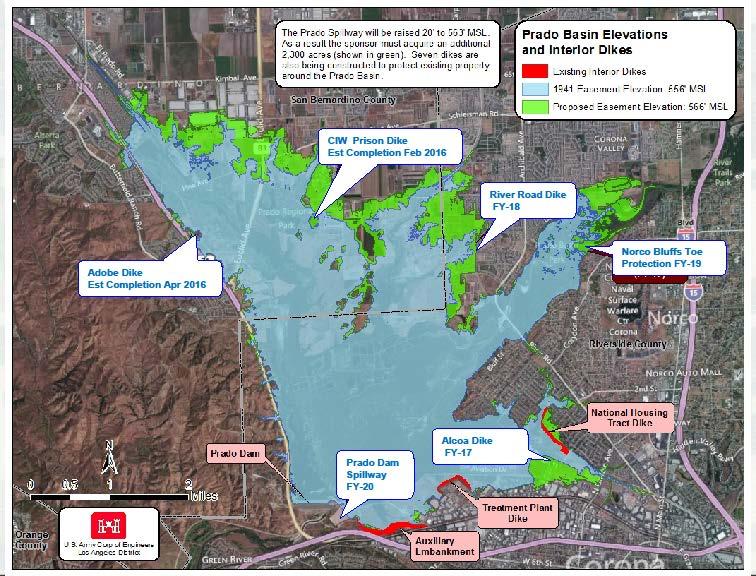
6 PRADO DAM RESERVOIR AND INTERIOR DIKES CIW DIKE HOUSING DIKE ADOBE DIKE 71 EMBANKMENT ST DIKE 5 OUTLET STRUCTURE PRADO SPILLWAY AUXILIARY EMBANKMENT


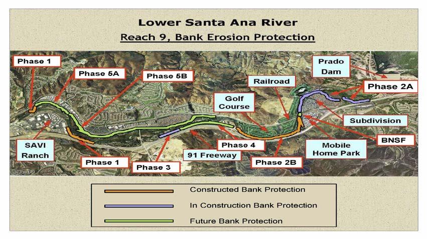
7 LOWER SANTA ANA RIVER REACH 9 PHASE 5B PHASE 5A PHASE 2A PHASE 1 BNSF BRIDGE PHASE 4 6 PHASE 3 PHASE 2B
8 7
9 8

10 9
11 10
12 QUESTIONS Damien A. Lariviere Senior Project Manager Santa Ana River Mainstem Project Civil Works Branch, Los Angeles District US Army Corps of Engineers (213) (Los Angeles Office) (951) (Prado Dam Office) (213) (Mobile)
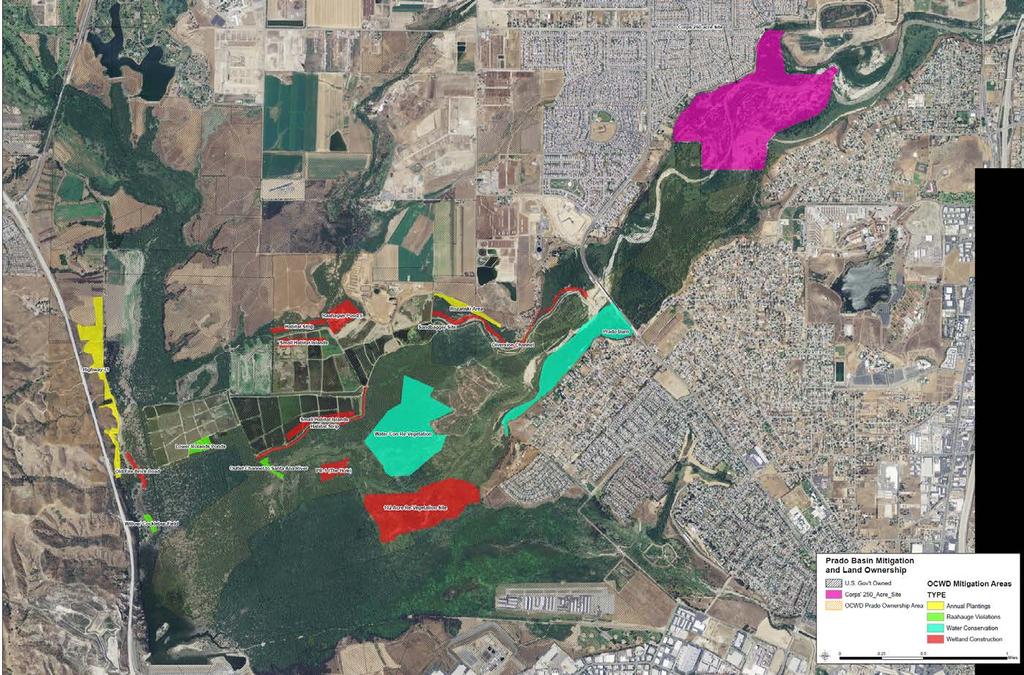
13 PRADO BASIN FEASIBILITY STUDY Ecosystem Restoration and Water Conservation
14 STUDY OVERVIEW 13 Dual-Purpose Study Ecosystem Restoration 1. Aquatic habitat restoration 2. Arundo and other non-native/invasive species removal 3. Expand and improve native habitat Water Conservation 1. Sediment removal and re-entrainment: Increase storage volume in basin, Prevent clogging of recharge areas 2. Water surface elevation increase to 505 feet year-round Non-Federal Sponsor: OCWD Sponsor implementing Demonstration Project for sediment re-entrainment ahead of Feasibility study Prado Basin Feasibility Study Update
 downstream of Dam to Pacific Ocean Prado Basin Feasibility Study")
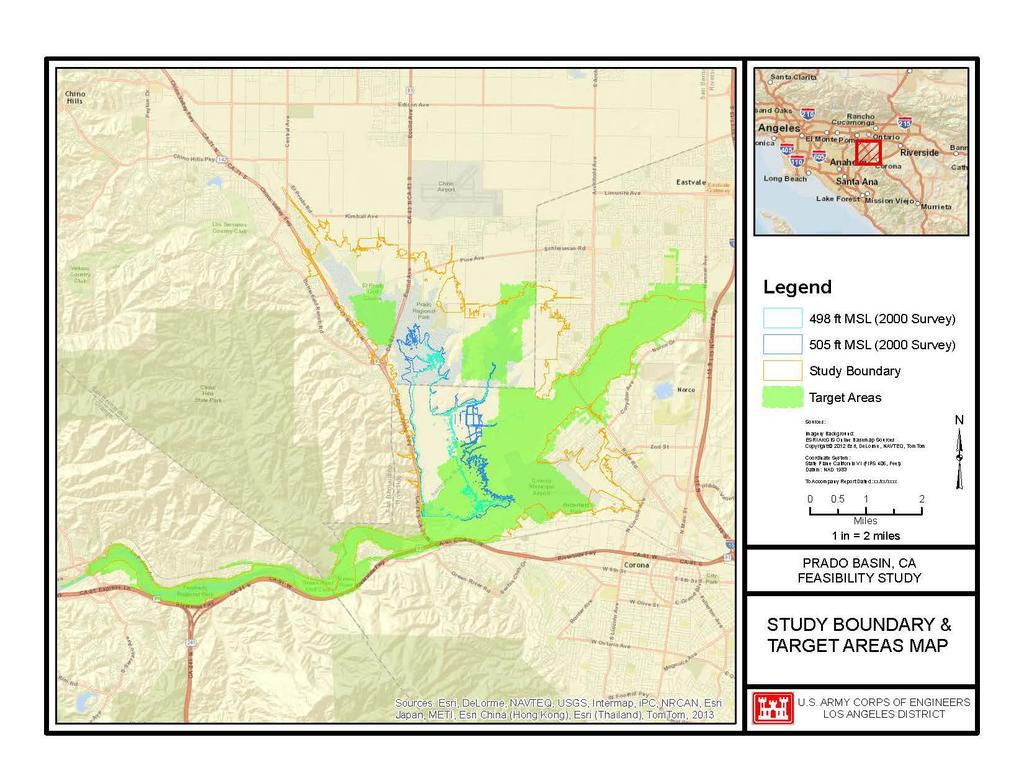
15 14 PRADO BASIN FEASIBILITY STUDY AREA Study area includes Prado Basin and Santa Ana River Mainstem (SARM) downstream of Dam to Pacific Ocean Prado Basin Feasibility Study Update
16 15
17 STUDY UPDATE 16 Complete Measure Formulation CHAP Analysis (Habitat Output Value Assessment) Economics Analysis Completed Reduced Array of Alternatives Identified Next Steps Identify TSP (Spring 2017) Draft IFR (Summer 2017) Chief of Engineers Report (Study Complete mid 2019) Prado Basin Feasibility Study Update
 and should not be construed as an official Department of the Army position, policy or decision,")
18 PRADO DAM MASTER PLAN UPDATE 17 Stakeholder Meeting Prepared by Wendy Loeffler, RECON Environmental & Megan Wong, USACE Los Angeles District For Inland Empire Utilities Agency Stakeholders 19 January 2017 File Name The views, opinions and findings contained in this report are those of the authors(s) and should not be construed as an official Department of the Army position, policy or decision, unless so designated by other official documentation.
19 PRADO DAM BASIN MASTER PLAN UPDATE Presentation Outline: Master Planning Overview and Guidance Prado Dam Basin History Master Plan Update Project History Review of need for update Overview of study area Review Objectives and Land Classifications Master Plan Update document outline Solicit data and input from stakeholders


20 PRADO DAM BASIN MASTER PLAN UPDATE Master Plans are prepared by the Corps of Engineers and govern the operations of the Corpsowned lands within the reservoirs. The plans are periodically updated to ensure that they reflect current conditions, as well as guide the vision of the future.
21 PRADO DAM BASIN MASTER PLAN UPDATE ER a.(1) guides development of the plans and provides the Program Mission. The Corps functions as the steward of the lands and waters and will: Manage/conserve natural resources per Natural Resources Management Mission Provide quality public outdoor recreation experiences Promote natural and cultural resources awareness, stewardship, protection, compliance and restoration Integrate the management of natural resources with public recreation Manage for long-term public access

22 PRADO DAM BASIN MASTER PLAN UPDATE Authorized by Congress in Construction completed in Primary authorized purpose for the Dam is: Flood Risk Management Secondary authorized purposes for the Basin are: Water Conservation Recreation Environmental Stewardship
23 PRADO DAM BASIN MASTER PLAN UPDATE Project Timeline Recreation Master Plan for the Prado Dam Reservoir Area 1990 s -- Revisions begun based on input from associated watershed projects Draft Master Plan Update and EIS prepared and submitted for public review; comments received resulted in a change in direction Overemphasis on Recreation Unclear presentation of environmental constraints Update reinstated but halted due to lack of funding resources Master Plan Update funded
24 PRADO DAM BASIN MASTER PLAN UPDATE Update needed based on landscape changes since 1976: Increase in the amount of sensitive biological resources Increase in visitation and variety of recreation opportunities. The changing profile of adjacent land uses Increase in development intensity Modifications to Dam and other areas within the basin Designation and restoration of lands as flood control mitigation Modifications to the Water Control Manual for water conservation Changes in recreation trail planning and implementation Proposed habitat restoration and expanded water conservation

25 PRADO DAM BASIN MASTER PLAN UPDATE DRAFT STUDY AREA **Draft boundary and Corps-owned parcels subject to final verification by the Corps

26 PRADO DAM BASIN MASTER PLAN UPDATE DRAFT PRIMARY LEASEES AND RECREATION **Draft boundary and Corps-owned parcels subject to final verification by the Corps


27 PRADO DAM BASIN MASTER PLAN UPDATE Plan Update Will Address: Flood Risk Management Safety Recreation Education and Interpretation Environmental Quality and Character Community Involvement Water, Soil, Air Quality Cultural Resources Visual and Auditory Quality Global Climate Change Wildlife Habitat Native Plant Communities
28 PRADO DAM BASIN MASTER PLAN UPDATE Land Classifications: Operations Lands used solely for operation of the dam (e.g. dam, spillway, levees, dikes, maintenance facilities, etc.) High Density Recreation Lands used for intensive recreation by the public (e.g. day use areas, campgrounds, public concessions, quasi-public development) Environmentally Sensitive Areas where scientific, ecological, cultural or aesthetic features have been identified.
29 PRADO DAM BASIN MASTER PLAN UPDATE Land Classifications (continued): Multiple Resource Management: Lands with one of the following predominate uses that also allow for other compatible uses Low Density Recreation - Passive recreational areas with minimal development Wildlife Management - Lands designated for fish and wildlife stewardship Vegetation Management - Lands designated for native vegetation stewardship
30 PRADO DAM BASIN MASTER PLAN UPDATE Land Classifications (continued): Multiple Resource Management Inactive or Future Recreation - Closed recreation areas or areas with characteristics compatible with future recreation. Lands will be managed for multiple use until recreational status changes. Other Uses (e.g. Agriculture, easements)
31 PRADO DAM BASIN MASTER PLAN UPDATE Draft Plan Document Outline: Project Authorization Project Description Planning Process including Community Workshops Land Allocations, Land Use and Resource Inventory (Existing Conditions) Land Classifications Resource Objectives Land Use and Resource Plan Recommendations Appendices

32 PRADO DAM BASIN MASTER PLAN UPDATE Next Steps: 2 nd Stakeholder Meeting and Input Preparation of Draft Plan 3 rd Stakeholder Meeting and Input Preparation of Final Draft Plan Megan Wong Project Environmental Coordinator Megan.T.Wong@usace.army.mil
33 PRADO DAM BASIN MASTER PLAN UPDATE Please tell us about: Your recent activities Areas of concern Safety Recreation Access Corridors Proposed future activities Studies or data collected Suggestions?
34
35
36
37
Lake O the Pines Master Plan Revision Public Information Meeting April 25 & 27, 2017
 Lake O the Pines Master Plan Revision Public Information Meeting April 25 & 27, 2017 Presented By Matthew Like, Lake Manager U.S. Army Corps of Engineers Fort Worth District US Army Corps of Engineers
Joe Pool Lake Master Plan Revision Public Information Meeting May 23, 2017
 Joe Pool Lake Master Plan Revision Public Information Meeting May 23, 2017 Presented By Jason Owen Lake Manager U.S. Army Corps of Engineers Fort Worth District US Army Corps of Engineers Purpose of this
Public Information Meeting
 Lavon Lake Master Plan Revision Public Information Meeting March 10, 2015 Presented By Michael Kinard Lake Manager U.S. Army Corps of Engineers Fort Worth District US Army Corps of Engineers Purpose of
Canyon Lake Master Plan Revision Public Information Meeting March 18, 2016
 Canyon Lake Master Plan Revision Public Information Meeting March 18, 2016 Marcus Schimank Canyon Lake Manager Capital Regional Office U.S. Army Corps of Engineers Fort Worth District US Army Corps of
Lewisville Lake Master Plan Revision Public Information Meeting May 2 & 4, 2017
 Lewisville Lake Master Plan Revision Public Information Meeting May 2 & 4, 2017 Presented By Rob Jordan Lake Manager U.S. Army Corps of Engineers Fort Worth District US Army Corps of Engineers Purpose
2011 ASLA Design Awards. Westside Creeks Restoration Plan Merit Award AECOM, Fort Collins. Planning & Urban Design
 2011 ASLA Design Awards Westside Creeks Restoration Plan Merit Award AECOM, Fort Collins Planning & Urban Design Project Fact Sheet Category of Entry: Rotating Specialty Award: 2011 2011 ASLA Colorado
Joe Pool Lake Lake Master Plan Public Information Meeting Presentation of Final Draft Revision July 31, 2018
 Joe Pool Lake Lake Master Plan Public Information Meeting Presentation of Final Draft Revision July 31, 2018 Presented By Jeremy Spencer Lake Manager U.S. Army Corps of Engineers Fort Worth District US
Raystown Lake Master Plan Revision. Public Meeting April 25 & 26, 2018 How does the revision process work?
 Raystown Lake Master Plan Revision Public Meeting April 25 & 26, 2018 How does the revision process work? What is a Master Plan? The Master Plan is the strategic land use management document that guides
Los Angeles River-Arroyo Seco Confluence Restoration Vision Plan. Professor Meredith McKenzie, JD Urban & Regional Planning Dept Cal Poly Pomona
 Los Angeles River-Arroyo Seco Confluence Restoration Vision Plan Professor Meredith McKenzie, JD Urban & Regional Planning Dept Cal Poly Pomona The Los Angeles River Watershed Arroyo Seco Watershed Map
Welcome. to the Bull Shoals Lake Master Plan Revision Open House
 Welcome to the Bull Shoals Lake Master Plan Revision Open House At the open house you can: Learn about the project Provide comments on the Draft Master Plan and Draft Environmental Assessment (EA) Watch
Pine Flat Lake Master Plan Update FACT SHEET September 2014
 Pine Flat Lake Master Plan Update FACT SHEET September 2014 PURPOSE AND OBJECTIVE The U.S. Army Corps of Engineers Sacramento District is revising the 1976 Pine Flat Lake Master Plan and is seeking public
STEWARDSHIP OF LONG ISLAND SOUND S ECOLOGICAL AND RECREATIONAL RESOURCES
 STEWARDSHIP OF LONG ISLAND SOUND S ECOLOGICAL AND RECREATIONAL RESOURCES Robin Kriesberg, Save the Sound, Inc. Thomas Halavik, US Fish and Wildlife Service Coastal Program An Initiative to Identify, Protect
MASTER PLAN TRAINING MODULE 1: INTRODUCTION
 MASTER PLAN TRAINING MODULE 1: INTRODUCTION 237 237 237 217 217 217 200 200 200 80 119 27 252 174.59 255 255 255 0 0 0 163 163 163 131 132 122 239 65 53 110 135 120 112 92 56 62 102 130 102 56 48 130 120
Improving Communities Through the Arroyo Seco Sustainability Campaign and Watershed Assessment
 Improving Communities Through the Arroyo Seco Sustainability Campaign and Watershed Assessment Arroyo Seco Headwaters in the San Gabriel Mountains Major tributary to the Los Angeles River 44 square mile
WELCOME! 8 8:30 6: TH STREET IMPROVEMENTS. Open House. Presentation & Q&A
 WELCOME! 168 TH STREET IMPROVEMENTS 6:30 Open House 7 8 Presentation & Q&A 8 8:30 Open House WELCOME Todd Pfitzer City of Omaha Engineer Bob Stubbe City of Omaha Public Works Director Jon Meyer Project
City of Missoula and Missoula County Open Space Planning Open House
 City of Missoula and Missoula County Open Space Planning Open House FEBRUARY 6, 2018 The following slides contain the display board content from the open house. Please use boards to answer questions in
EAU GALLE PROJECT MASTER PLAN APPENDIX C PUBLIC INVOLVEMENT
 EAU GALLE PROJECT MASTER PLAN APPENDIX C PUBLIC INVOLVEMENT SPRING VALLEY, WISCONSIN April 2019 1 Introduction EAU GALLE PROJECT MASTER PLAN APPENDIX C PUBLIC INVOLVEMENT The master planning process recognizes
California Environmental Quality Act (CEQA) Environmental Review Process
 Environmental Review Process") California Environmental Quality Act (CEQA) Environmental Review Process Los Angeles Union Station Forecourt and Esplanade Improvements constitute a Project Los Angeles County Metropolitan Transportation
California Environmental Quality Act (CEQA) Environmental Review Process Los Angeles Union Station Forecourt and Esplanade Improvements constitute a Project Los Angeles County Metropolitan Transportation
PARKS AND RECREATION
 PARKS AND RECREATION WHAT YOU WILL FIND IN THIS CHAPTER: Background information on the development of the Park, Recreation, and System Plan (PRSP). General overview of Ellensburg s parks and recreation
Your town s subdivision or land use ordinance standards should reference the following street standards, for example:
 Your town s subdivision or land use ordinance standards should reference the following street standards, for example: Streets shall be designed to move traffic safely and in a way that minimizes environmental
RE: Application for FERC Project No , Scott s Mill dam hydropower proposal
 RE: Application for FERC Project No. 14425, Scott s Mill dam hydropower proposal To Whom It May Concern: James River Association (JRA) is a conservation organization that has been solely dedicated to restoring
Middle Mississippi River. Regional Corridor
 Middle Mississippi River St. Louis District Regional Corridor Lessons Learned from a Collaborative Planning Study Brian Johnson US Army Corps of Engineers 12 th Biennial Governor s Conference on the Management
Scope of Services. River Oaks Boulevard (SH 183) Corridor Master Plan
 Corridor Master Plan") Scope of Services River Oaks Boulevard (SH 183) Corridor Master Plan PROJECT AREA The project area consists of the River Oaks Boulevard (SH 183) corridor bounded by SH 199 at the northern end and the Trinity
Scope of Services River Oaks Boulevard (SH 183) Corridor Master Plan PROJECT AREA The project area consists of the River Oaks Boulevard (SH 183) corridor bounded by SH 199 at the northern end and the Trinity
Chapter 5: Recreation
 Chapter 5: Recreation Introduction and Setting Recreational opportunities within Nevada County are varied, ranging from public parks with intensively used active recreational facilities, to vast tracts
Commercial Launch Site Addendum to Wetland Mitigation Plan. Revision 2. April 25, SpaceX Proprietary
 Commercial Launch Site Addendum to Wetland Mitigation Plan Revision 2 April 25, 2017 SpaceX Proprietary Contents 1.0 Project Information... 1 1.1 Background... 1 2.0 Compensatory Mitigation... 2 2.1 Goals
Highlands Region Stormwater Management Program Guidance
 DRAFT Highlands Region Stormwater Management Program Guidance Release Date: January 2016 Abstract This guidance document provides an overview of the Highlands Stormwater Management Program. It is intended
Southwest Fleetwood Enclave
 Southwest Fleetwood Enclave Development Concept Plan Southwest Fleetwood Enclave 1 st Land Owners Meeting April 30 th, 2012 Presentation Overview Why the Plan? ; Overview & Purpose of Study; Constraints
Arkansas River Corridor
 Planning for Access Welcome to the Access Project. This project is a recreational planning effort in response to an interest by regional communities along the Arkansas River corridor. The project plan
DRAFT MAP AMENDMENT FLU 04-4
 DRAFT MAP AMENDMENT FLU 04-4 SW 24 TH AVENUE ROADWAY CORRIDOR The University of Florida participates with the Metropolitan Transportation Planning Organization (MTPO) in its responsibilities for the continuing,
WASHINGTON COUNTY OREGON
 WASHINGTON COUNTY OREGON LONG RANGE PLANNING DIVISION North Bethany Subarea Stream Corridors: Existing Regulations In Oregon, there is a distinct difference between the land use rules that apply in rural
PURPOSE: The purpose is to provide commercial facilities in the Vancouver and Clark County vicinity.
 US Army Corps of Engineers Seattle District Joint Public Notice Application for a Department of the Army Permit and a Washington Department of Ecology Water Quality Certification and/or Coastal Zone Management
Zoning Ordinance Chapter 10
 CHAPTER 10 - WASHES SECTION 10.0 GENERAL: A. The purpose of this Ordinance is to establish standards for development in or near Major and Minor Washes as defined in Appendix A Glossary of Terms and Definitions
Minot City Council -Special Meeting- Friday, July 21, :00 PM Minot City Council Chambers- City Hall
 Minot City Council -Special Meeting- Friday, July 21, 2017 12:00 PM Minot City Council Chambers- City Hall You are hereby notified pursuant to the authority vested in me as City Manager of the City of
ADOPTION OF THE REVISED OPEN SPACE AND CONSERVATION ELEMENT OF THE GENERAL PLAN
 TO: FROM: SUBJECT: Honorable Mayor and City Council Planning Department ADOPTION OF THE REVISED OPEN SPACE AND CONSERVATION ELEMENT OF THE GENERAL PLAN RECOMMENDATION: It is recommended that the City Council:
3-2 Environmental Systems
 3-2 Environmental Systems 3.0 ENVIRONMENTAL SYSTEMS CONTENTS 3.1 GREENWAY SYSTEM 3.1.1 General Policies 3.1.2 Natural Heritage Network 3.1.3 Natural Heritage Network Enhancement Lands 3.1.4 Rouge Watershed
Template for Restoration in a Lake Superior Area of Concern. Template for Restoration in a Lake Superior Area of Concern
 Keith Bowers, Principal Ivette Bolender, Great Lake Bioregion Team Leader Presentation outline: Project background Master planning process Habitat restoration approach Lessons learned Hog Island and Newton
Inventory and Management Recommendations for Future Recreational Needs
 Inventory and Management for Future Recreational Needs Greenway Corridor Draft Report Prepared for: Woodbury Park and Recreation Submitted by: Jon Benson, Project Manager Tara Grover, Mark Gustafson, Pamela
SCC PRD (2016) COUNTY PARK MASTER PLAN
 COUNTY PARK MASTER PLAN") SCC PRD (2016) COUNTY PARK MASTER PLAN MASTER PLAN UPDATE PARKS AND RECREATION COMMISSION NOVEMBER 7, 2018 PURPOSE OF THE MASTER PLAN The Sanborn County Park Master Plan will provide the Department with
SCC PRD (2016) COUNTY PARK MASTER PLAN MASTER PLAN UPDATE PARKS AND RECREATION COMMISSION NOVEMBER 7, 2018 PURPOSE OF THE MASTER PLAN The Sanborn County Park Master Plan will provide the Department with
San Diego River Coalition 2012 Work Plan
 San Diego River Coalition 2012 Work Plan Adopted November 18, 2011 The mission of the San Diego River Coalition is preserve and enhance the San Diego River, its watershed, and its natural, cultural and
138 ATTACHMENT 17. DEPARTMENT OF THE ARMY WlLMlNGTON DISTRICT, CORPS OF ENGINEERS
 138 ATTACHMENT 17 DEPARTMENT OF THE ARMY WlLMlNGTON DISTRICT, CORPS OF ENGINEERS B. EVERETT JORDAN DAM AND LAKE P.O. Box 144 MONCURE, NORTH CAROLINA 27559 April 11, 2007 Mr. Scott Radway Radway Design
Parks, Open Space and Trails
 Introduction Parks have often been referred as the lungs of our cities, cleansing the air of pollutants and particulate matter. Parks are also gathering places for families and community. They offer spaces
Draft Rhode Island Stormwater Design and Installation Standards Manual
 Draft Rhode Island Stormwater Design and Installation Standards Manual Summary The May 2009 Public Review Draft version of the RI Stormwater Design and Installation Standards Manual consists of approximately
Planning for Staten. Habitat Restoration and Green Infrastructure. Island s North Shore
 Habitat Restoration and Green Infrastructure Planning for Staten Island s North Shore Community Board 1 March 1, 2018 NYC Parks Forestry, Horticulture, and Natural Resources Funded by the NYS Department
Peoria Riverfront Development (Ecosystem Restoration) Upper Mid-sized Island Critical Restoration Project (September 2011)
 Upper Mid-sized Island Critical Restoration Project (September 2011)") Peoria Riverfront Development (Ecosystem Restoration) Upper Mid-sized Island Critical Restoration Project (September 2011) Description The Corps of Engineers, Rock Island District (District) and the Illinois
Peoria Riverfront Development (Ecosystem Restoration) Upper Mid-sized Island Critical Restoration Project (September 2011) Description The Corps of Engineers, Rock Island District (District) and the Illinois
One River Environmental Assessment. Welcome!
 One River Environmental Assessment Welcome! One River Environmental Assessment Welcome to the One River Environmental Assessment Public Information Centre. Please explore each presentation area to learn
This page intentionally blank.
 This page intentionally blank. Parks, Recreation, and Open Space Chapter Relationship to Vision Vision Parks, Recreation and Open Space Chapter Concepts County Government. County government that is accountable
Shoreline Master Program Town of La Conner, Washington
 Shoreline Master Program Town of La Conner, Washington Department of Ecology approval effective Adopted September 24, 2013 by Town of La Conner Ordinance No.1106 Amended May 13, 2014 by Town of La Conner
Stream Corridor Management Plan
 Stream Corridor Management Plan A unified and comprehensive approach to protecting, restoring and managing the Upper Delaware River Graydon Dutcher Delaware County Soil and Water Conservation District
Community Conservation Workshop. Saranac River Basin Communities
 Community Conservation Workshop Saranac River Basin Communities 2 Community Conservation Program Welcome! We have designed a Community Conservation Program that listens to the needs of community members.
Community Conservation Workshop. Lake Placid
 Community Conservation Workshop Lake Placid 2 Community Conservation Program Welcome! We have designed a Community Conservation Program that listens to the needs of community members. We are conducting
Regional Open Space Conservation Plan. Regional Staff Committee January 18, 2018
 Regional Open Space Conservation Plan Regional Staff Committee January 18, 2018 Schedule We are here Task 1 - Stakeholder Input & Work Plan Dev. v z 2016 2017 2018 Oct Nov Dec Jan Feb Mar Apr May Jun Jul
EXHIBIT A CITY OF FORT WALTON BEACH, FLORIDA COASTAL MANAGEMENT & CONSERVATION
 EXHIBIT A CITY OF FORT WALTON BEACH, FLORIDA INTRODUCTION The Coastal Management and the Conservation Elements required by Chapter 9J-5.012 and 5.013, F.A.C., respectively, have been combined into one
Overview of Southwestern Pennsylvania Commission s (SPC) 2040 Long Range Transportation Plan (LRTP)
 2040 Long Range Transportation Plan (LRTP)") Overview of Southwestern Pennsylvania Commission s (SPC) 2040 Long Range Transportation Plan (LRTP) Presented to Pennsylvania Agency Coordination Meeting May 27, 2015 Doug Smith & Ryan Gordon 1 Southwestern
Overview of Southwestern Pennsylvania Commission s (SPC) 2040 Long Range Transportation Plan (LRTP) Presented to Pennsylvania Agency Coordination Meeting May 27, 2015 Doug Smith & Ryan Gordon 1 Southwestern
Alternative Routes. St. Vital to La Verendrye Station - Southern Loop Transmission Corridor. 20 different segments 4 segments common to all routes
 Alternative Routes St. Vital to La Verendrye Station - Southern Loop Transmission Corridor In a fixed right-of-way St. Vital to Letellier Station 20 different segments 4 segments common to all routes Goal
Ashbridges Bay Erosion and Sediment Control Project
 Ashbridges Bay Erosion and Sediment Control Project Project Brief Overview Toronto and Region Conservation Authority, in partnership with the City of Toronto, intends to carry out remedial erosion control
Surrey Ecosystem Management Study
 Surrey Ecosystem Management Study Green Infrastructure Network Opportunities Public Open House & Information Session June 24 th, 2010 EMS Process Ecological Inventory Ecological Assessment Management Policy
RECREATION AND OPEN SPACE ELEMENT GOALS, OBJECTIVES, AND POLICIES
 RECREATION AND OPEN SPACE ELEMENT GOALS, OBJECTIVES, AND POLICIES Goal 7 To provide park facilities, recreation programs, and open space resources that are safe, adequate, and accessible to all City residents,
Support the implementation of Cape Coral's Comprehensive Plan. Protect and utilize the unique natural resources in the City.
 7.0 OVERVIEW - RECOMMENDATIONS Chapter 7 The preparation of the Cape Coral Parks and Recreation Master Plan spanned a period of approximately 12 months. Plan preparation included the input of a wide range
City of Surrey Ecosystem Management Study. Integration of ecological processes with land use
 City of Surrey Ecosystem Management Study Integration of ecological processes with land use Natural areas in Surrey are changing as the City grows and evolves. Many important natural areas remain or may
Pittsburgh District Pittsburgh, PA Notice No Closing Date: May 29, 2015
 Public Notice U.S. Army Corps In Reply Refer to US Army Corps of Engineers, Pittsburgh District of Engineers Notice No. below 1000 Liberty Avenue Pittsburgh District Pittsburgh, PA 15222-4186 Application
Otay Regional Trail Alignment Study. Public Workshop March 14 th, 2017 from 5:30-8 p.m.
 Public Workshop March 14 th, 2017 from 5:30-8 p.m. Purpose of the Study A multi-agency planning effort to create a coordinated and sustainable trail system that enhances recreation and provides trail connections
Waverley West B Secondary Planning Process. Open House South Pointe School April 25, 2018
 averley est B Secondary Planning Process South Pointe School April 25, 2018 averley est B Secondary planning process open house Please review the boards and provide your feedback. 1 The Role of a Secondary
HAZARD MITIGATION GOALS AND OBJECTIVES
 SEWRPC Community Assistance Planning Report No. 282, 2nd Edition CITY OF MILWAUKEE ALL HAZARDS MITIGATION PLAN UPDATE Chapter IV HAZARD MITIGATION GOALS AND OBJECTIVES [NOTE: Throughout this plan update
Corridor Management Committee. September 29, 2017
 Corridor Management Committee September 29, 2017 1 Today s Topics Chair s Update Proposed Corridor Protection Wall Aesthetic Design Overview Public Outreach Environmental Review Civil Construction Update
Master Plan Objectives and Policies
 Master Plan Objectives and Policies Introduction This chapter identifies the Park issues and recommended policies established by this Master Plan. The issues were identified through meetings with staff,
Lower Don River West Remedial Flood Protection Project TABLE OF CONTENTS. Page. Executive Summary
 TABLE OF CONTENTS Page Executive Summary 1.0 INTRODUCTION...1-1 1.1 Purpose of the Undertaking...1-1 1.2 Study Area Description...1-1 1.3 Description of the Undertaking...1-1 1.4 Rationale for the Undertaking...1-2
OFFICIAL COMMUNITY PLANS (OCPs) AND ZONING BYLAWS (ZBs): PLANNING FOR THE FUTURE
 AND ZONING BYLAWS (ZBs): PLANNING FOR THE FUTURE") OFFICIAL COMMUNITY PLANS (OCPs) AND ZONING BYLAWS (ZBs): PLANNING FOR THE FUTURE Official Community Plan Workshop January 20, 2016 Frontier, SK SARM Community Planning Services SARM the voice of rural
OFFICIAL COMMUNITY PLANS (OCPs) AND ZONING BYLAWS (ZBs): PLANNING FOR THE FUTURE Official Community Plan Workshop January 20, 2016 Frontier, SK SARM Community Planning Services SARM the voice of rural
Town of Peru Comprehensive Plan Executive Summary
 Town of Peru Comprehensive Plan Executive Communities that plan grow by choice, not by chance. A plan makes growth thoughtful, understandable, and predictable. A plan shows that a community is managing
Blue/Green Infrastructure Study Accomack County, VA
 Blue/Green Infrastructure Study Accomack County, VA Draft Asset Maps March 8-9, 2010 Green Infrastructure Center, Inc. 2 Overview What is Green and Blue Infrastructure Project Timeline & Tasks Literature
FAQ S about Restoration Planning FROM THE Department of Ecology WEBSITE:
 FAQ S about Restoration Planning FROM THE Department of Ecology WEBSITE: http://www.ecy.wa.gov/programs/sea/sma/st_guide/smp/restoration/qanda.html Notations in parentheses are staff notes directing you
2. AGENCY COORDINATION AND PUBLIC INVOLVMENT
 2. AGENCY COORDINATION AND PUBLIC INVOLVMENT This chapter discusses the process carried out for conducting agency coordination and public involvement activities. TECHNICAL ADVISORY COMMITTEE A Technical
Toronto Complete Streets Guidelines Stakeholder Advisory Group #
 Toronto Complete Streets Guidelines Stakeholder Advisory Group #1 2015-03-24 What are Complete Streets? 2 Streets designed with all users in mind: pedestrians/those with disabilities cyclists street car
NORTHEAST RIVER CROSSING FUNCTIONAL PLANNING STUDY
 WELCOME Northeast River Crossing Functional Planning Study Phase 2 Public Meeting 4 to 8 PM Informal drop-in format and discussion tables Meeting Purpose Introduce the Northeast River Crossing Functional
Phase 2 Eden Landing Ecological Reserve Scoping Meeting for EIS/EIR. June 30, 2016
 Phase 2 Eden Landing Ecological Reserve Scoping Meeting for EIS/EIR June 30, 2016 Today s Purpose Introduction to Scoping / Purpose of Meeting South Bay Salt Pond Restoration Project Project Overview EIS/EIR
COLLIER BOULEVARD (CR 951) CORRIDOR
 CORRIDOR") Project(s) Goals Improve Traffic Circulation, Capacity & Safety Focus on Safety During Design & Construction Address Public Concerns Design an Aesthetically Pleasing Project Limit Environmental Impacts
Project(s) Goals Improve Traffic Circulation, Capacity & Safety Focus on Safety During Design & Construction Address Public Concerns Design an Aesthetically Pleasing Project Limit Environmental Impacts
The Rocky Mountain Arsenal and the Northeast Greenway Corridor Project:
 The Rocky Mountain Arsenal and the Northeast Greenway Corridor Project: Contamination to Collaboration Presented by Howard Kenison Overview of Presentation Rocky Mountain Arsenal Contamination Litigation,
CITY OF LONDON COVES ESA CONSERVATION MASTER PLAN COMMUNITY WORKSHOP #1
 CITY OF LONDON COVES ESA CONSERVATION MASTER PLAN COMMUNITY WORKSHOP #1 January 28 th 2014 Welcome! Purpose Reintroduce the Coves Conservation Master Plan (CMP) process; Provide an overview of Phase 1
JOINT PUBLIC NOTICE. 26 June United States Army Corps of Engineers State of Louisiana
 JOINT PUBLIC NOTICE 26 June 2017 United States Army Corps of Engineers State of Louisiana New Orleans District Department of Environmental Quality Regulatory Branch Office of Environmental Services 7400
ADOPTED CAPITAL IMPROVEMENT PROGRAM BUDGET ARROYO PROJECTS
 ADOPTED CAPITAL IMPROVEMENT PROGRAM BUDGET ARROYO PROJECTS HAHAMONGNA FY 212-216 Capital Improvement Program Priority Description Total Estimated Costs Appropriated Through FY 211 Adopted FY 212 FY 213
APPENDIX I Presentations
 APPENDIX I Presentations Workshop Summary Report 11 Peel Region Official Plan Review May 5, 2010 Compatible Active Recreation Workshop July 29, 2010 Components of PROPR Sustainability Planning Tools/Updates
OPEN SPACE CHAPTER 7: OVERVIEW. Preserve open space to protect natural resources, enhance character and provide passive recreation opportunities
 CHAPTER 7: OPEN SPACE OVERVIEW Ridgefield has made tremendous progress permanently preserving areas of town as open space. Open space preservation can serve many important purposes, including: protect
Wisconsin downtown action council Downtown project case study profile
 Wisconsin downtown action council Downtown project case study profile Project Name Onalaska Waterfront Project Location City of Onalaska Project Type (check all that apply) g Residential g Commercial g
CECW-AG 11 June 1998 MEMORANDUM FOR MAJOR SUBORDINATE COMMANDS AND DISTRICT COMMANDS
 CECW-AG 11 June 1998 MEMORANDUM FOR MAJOR SUBORDINATE COMMANDS AND DISTRICT COMMANDS SUBJECT: Policy Guidance Letter No. 59, Recreation Development at Ecosystem Restoration Projects 1. References: a. ER
Preservation of Scenery National Historic Trails. Rob Sweeten BLM Kevin Rauhe EPG
 Preservation of Scenery National Historic Trails Rob Sweeten BLM Kevin Rauhe EPG EPG Background Landscape architects with expertise in visual resources Resource staff includes: archaeologists, biologists,
Summary of Changes in the DRAFT Rivers Project Natural Resource Master Plan from the 2001 approved plan to 2014 plan
 Summary of Changes in the DRAFT Rivers Project Natural Resource Master Plan from the 2001 approved plan to 2014 plan The entire Master Plan format and layout has been changed to comply with regulation
DRAFT Anan Wildlife Observatory Recreation Site Master Plan. Prepared by: Wrangell Ranger District Tongass National Forest Alaska
 DRAFT Anan Wildlife Observatory Recreation Site Master Plan Prepared by: Wrangell Ranger District Tongass National Forest Alaska December, 2015 Signature Sheet Approved: James King Director of Recreation,
Project Team. 2M Associates. City of Saratoga. HT Harvey Biology. PlaceWorks. NV5 Infrastructure. Tom Origer Associates History/Archeology
 Project Team City of Saratoga John Cherbone, Director of Public Works Iveta Harvancik, Senior Engineer PlaceWorks Isabelle Minn, Principal-in-Charge Isby Fleischmann, Project Manager Kyle Simpson, CEQA
COASTAL CONSERVANCY. Staff Recommendation March 25, 2004 LOS ANGELES GREEN VISION PLAN. File No.: Project Manager: Marc Beyeler
 COASTAL CONSERVANCY Staff Recommendation March 25, 2004 File No.: 04-014 Project Manager: Marc Beyeler RECOMMENDED ACTION: Authorization to disburse up to $50,000 to the University of Southern California
Photo by Carlton Ward Jr. Executive Summary
 Photo by Carlton Ward Jr. Executive Summary The Cooperative Conservation Blueprint (Blueprint) is a multi-partner strategic conservation process developed by the Florida Fish and Wildlife Commission (FWC)
4. What are the goals of the Kawarthas, Naturally Connected project? 7. What are watersheds and why are they being used as the project boundaries?
 Frequently Asked Questions (FAQs) 1. What are Natural Heritage Systems (NHS)? 2. Why are they important? 3. Which areas of the province have undertaken NHS projects? 4. What are the goals of the Kawarthas,
RECREATION, OPEN SPACE AND GREENWAYS ELEMENT GOALS, OBJECTIVES, AND POLICIES
 RECREATION, OPEN SPACE AND GREENWAYS ELEMENT GOALS, OBJECTIVES, AND POLICIES GOAL R-1: DEVELOP A RECREATION, OPEN SPACE AND GREENWAYS SYSTEM AS AN INTEGRAL COMPONENT OF AN OVERALL, COUNTY-WIDE ECONOMIC
CONSERVATION ELEMENT GOALS, OBJECTIVES, AND POLICIES
 CONSERVATION ELEMENT GOALS, OBJECTIVES, AND POLICIES Goal 4 To conserve, manage, appropriately use and protect the natural resources of the City ensuring continued resource availability and environmental
3. VISION AND GOALS. Vision Statement. Goals, Objectives and Policies
 Vision Statement Queen Creek s interconnected network of parks, trails, open spaces and recreation opportunities provide safe and diverse activities and programs that sustain its unique, small town, equestrian
INDEPENDENCE BOULEVARD AREA PLAN. June 24, 2008
 INDEPENDENCE BOULEVARD AREA PLAN Public Meeting #1 June 24, 2008 Tonight s Agenda Introduction Welcome and Ground Rules Overview Presentation Purpose of the Plan What Brings Us Here? A Tour of the Corridor
Appendix E Preliminary Location Hydraulic Study
 Appendix E Prepared for: State of Alaska Department of Transportation and Public Facilities Prepared by: HDR Alaska, Inc. 2525 C Street, Suite 305 Anchorage, Alaska 99503 February 2014 This page intentionally
Meeting Agenda. City of Guelph. River Systems Advisory Committee. Agenda Items. Item 1, 2 and 3. Item 4 Ward to Downtown Pedestrian Bridge
 Meeting Agenda City of Guelph River Systems Advisory Committee September 19, 2018 City Hall, Meeting Room B From 4:00 to 6:00 p.m. Meeting Chair: Mariette Pushkar Agenda Items Welcome to all Item 1, 2
DEVELOPMENT PERMIT SENSITIVE ECOSYSTEMS
 DEVELOPMENT PERMIT SENSITIVE ECOSYSTEMS What is the Sensitive Ecosystem Development Permit Area (SEDPA)? Surrey s SEDPA is made up of two distinct classifications of the natural environment: Streamside
Citywide Integrated Stormwater Management Plan (ISMP) DRAFT ACTION PLAN REVIEW Public Consultation November 16 th, 2016
 DRAFT ACTION PLAN REVIEW Public Consultation November 16 th, 2016") Citywide Integrated Stormwater Management Plan (ISMP) DRAFT ACTION PLAN REVIEW Public Consultation November 16 th, 2016 1 Agenda DRAFT ACTION PLAN REVIEW Public Consultation Time 6:00 6:05 6:05 6:20 6:20
Citywide Integrated Stormwater Management Plan (ISMP) DRAFT ACTION PLAN REVIEW Public Consultation November 16 th, 2016 1 Agenda DRAFT ACTION PLAN REVIEW Public Consultation Time 6:00 6:05 6:05 6:20 6:20
STREAM BUFFERS
 88-415 STREAM BUFFERS 88-415-01 PURPOSE In the Kansas City region and throughout the nation, vegetated stream buffers have been clearly shown to protect stream stability and related infrastructure, improve
SECTION IV: DEVELOPMENT CONCEPT
 80 SECTION IV: DEVELOPMENT CONCEPT Section IV: DEVELOPMENT CONEPT This section provides an overall understanding and rationale for what is envisioned in The Preserve, the intended quality and character