Main Street Streetscape Plan. Downtown Redevelopment Plan Phase One
|
|
|
- Terence Cameron
- 5 years ago
- Views:
Transcription

1 2012 Main Street Streetscape Plan Downtown Redevelopment Plan Phase One

2 Message from Council Council Left to right: Dwight Ganske, Judy Bennett, Darren Badry, Mayor Ken Lemke, Robert Twerdoclib, Pat Hansard, William Choy. Council as of February 2012 On behalf of the Town of Stony Plain, we are pleased to share with you the Main Street Streetscape Plan. The Plan represents an important step in our ongoing commitment to enhancing the downtown as a destination for residents, businesses and visitors. The Main Street Streetscape Plan builds on the comprehensive strategy that has been created to nurture and preserve our historic downtown core. The Plan has been developed through extensive community consultation and professional guidance. We would like to acknowledge the leadership and contribution of the Downtown Redevelopment Working Group, which consists of representation from our local business community; specifically, Mardy Kulak, Sandi Hrycun and Ed Berney. Their time and input has been invaluable in developing an ambitious, but realistic, plan that is appropriate for our downtown. The Working Group will continue its role over the next few years, as we move the Plan into the detailed design and construction stages. In addition, it will provide input and support into Council's creation of a Downtown Area Redevelopment Plan. The Redevelopment Plan will provide a long - term vision for the growth and prosperity of downtown an essential part of our community. We look forward to the implementation of this exciting project and witnessing the positive long-term impact it will have on Stony Plain. Yours sincerely, Stony Plain Council 1


, which provides a holistic and long-term direction for the town.")
3 Background Main Street Stony Plain The Heart of Town Parking Study completed in 2009 Downtown Charrette - October The commercial district on either side of 50 Street, from 54 Avenue to 49 Avenue, is known as Main Street and is a fine example of Stony Plain s small-town ambiance. Over the years, as recreational facilities, schools, parks, homes and businesses were developed throughout the town, the downtown area emerged as a place where many significant cultural events took place. The majority of the buildings and streets in the downtown area are more than 50 years old, and targeted reinvestment is needed to maintain the downtown as a cultural and commercial centre for future generations to enjoy. In 2007, Council established the Community Sustainability Plan (CSP), which provides a holistic and long-term direction for the town. It addresses four major themes of sustainability: social equity, economic viability, cultural viability and environmental responsibility. Council established the Downtown Redevelopment Working Group to prepare a plan that would encourage a mix of commercial and residential land uses while strengthening the cultural amenities in the neighbourhood. The Downtown Redevelopment Working Group spent much of its time studying the downtown area to understand what makes this neighbourhood special in our community. The Group researched the cultural activities and amenities, design elements from past revitalization efforts and the neighbourhood's existing characteristics. A Parking Study was also completed in the spring of That fall, of 2009 the Town retained the services of Earthscape Consultants to assist the Working Group in consulting directly with the community through a charrette. The charrette, which was held over a three-day-period, included Stony Plain residents and business owners, particularly those in the downtown area. The Downtown Design Charrette Report was presented to Council in November Council directed Administration and the Working Group to develop a comprehensive implementation plan for the streetscape, programming and marketing of the downtown. Using input gathered from the charrette observations of the Working Group and the principles set by Town Council in the Municipal Development Plan, the Working Group developed a visions tatement for downtown Stony Plain: Downtown Stony Plain as a vibrant mixed-use neighbourhood, which builds upon its past, and where people can shop, live, work and play. As the water and sewer infrastructure below 50 Street is in need of an upgrade, the Downtown Working Group decided to focus on the 50 Street (Main Street) Streetscape and minimize the impact of the construction while addressing some of the key recommendations in the Charrette Report. Future phases will address other areas of downtown redevelopment, as identified in the Charrette Report. The Stony Plain Main Street Streetscape Plan aims to build on the existing small-town-feel of the historic downtown area by: enhancing the pedestrian environment establishing bicycle route linkages improving landscaping increasing seating opportunities developing traffic-calming features enhancing spaces for cultural events nurturing unique shopping, dining and gathering experiences The following represents an overview of the conceptual plan for Phase One of the redevelopment of Stony Plain s downtown streetscape.


4 Existing Downtown Elements Historic, downtown Stony Plain has approximately 70 businesses and a mix of single-family homes, apartments, schools, playgrounds and churches. coach-style lamposts with hanging baskets lanscaped curbs traditional wood signposts decorative trash receptacles heritage-style wood benches unique paving historic murals The majority of the commercial space is centered along 50 Street, from 49 Avenue to 54 Avenue. This corridor, just two blocks east of Highway 779, features primarily locally owned, small-town restaurants, a grocery and hardware store, boutiques, salons, financial institutions and offices for a variety of service providers. 50 Street (Main Street) has angle parking, while nearby avenues feature parallel parking. There are several small parking lots in the area. There is also limited parking in the back lanes, which are often used by business staff and delivery trucks. The downtown streetscape area includes coach-style lighting, benches, garbage receptacles, landscaping, trees and murals, which celebrate and highlight important historical events within Stony Plain. The water and sewer infrastructure that runs along 50 Street has been scheduled for replacement as part of the Town's 10-year Capital Improvement Plan. This construction will likely disturb the majority of the streetscape. The proposed streetscape improvements could coincide with the infrastructure improvements to minimize the the adverse affects on the downtown area. 3
 Presently")


5 Downtown Neighbourhood (Old Town) Presently there is no consistent name for the downtown neighbourhood, sometimes referred to as Old Town. Downtown and Old Town names are used throughout this document. 4
 North Gateway (page 6) Intersection (page 11) Centre Island (pages 8 & 9) Bike Path & Laneway Crossing")
6 Main Street Streetscape Key Plan Midblock Crossing (page 10) Bike Path & Laneway Crossing (page 7) South Gateway (page 12) North Gateway (page 6) Intersection (page 11) Centre Island (pages 8 & 9) Bike Path & Laneway Crossing (page 7) 5


7 North Gateway Concept - 49 Avenue & 50 Street (Main Street) conceptual plan view of north gateway Key Purposes: Create a sense of arrival at this important gateway into historic downtown Reduce traffic speed and create a safe crossing for pedestrians and cyclists Constraints: Improvements in this area must take into consideration possible future alignment/extension of 49 Avenue and must not interfere with safety and sightlines Proposed Improvements: Gateway signage Public art display (exact location to be determined) Enhanced greenspace on the east side, including shrubs, large rocks and trees Enhanced crosswalk with distinctive paving, benches and raised-brick, landscaped planters Refinish existing traditional benches, garbage receptacles and lighting Upgraded concrete sidewalk to the east side of the street perspective view of north gateway entrance feature 6


8 Bike Path & Laneway Crossing Concept Plan view of improvements to the laneway crossing, using 52 Avenue as an example Key Purpose: Enhance laneways and create a cycling route into and through the downtown Constraints: Parking will be adjusted at each crossing for safety and sightlines. Driveway and building frontage will be considered at each crossing. Further consideration will be given to traffic signs, line-markings and crossings for the laneway bike-path during the detailed design stage. Perspective view facing south at the 52 Avenue laneway crossing Proposed Improvements: Flared curbs to provide traffic-calming and safer crossings for cyclists and pedestrians Raised-brick, landscaped planters Paved, line markings and lighting to the bike-path laneway 7
 Key Purpose: Create a focal point to display public art, stage festivals, events and showcase the annual community Christmas")
9 Centre Island Concept - 51 Avenue & 50 Street (Main Street) Plan view of improvements to the 51 Avenue & 50 Street (Main Street) intersection. Dotted-line indicates the turning radius for large vehicles (fire trucks) Key Purpose: Create a focal point to display public art, stage festivals, events and showcase the annual community Christmas tree Constraints: Improvements must not interfere with safety or sightlines and must allow for large vehicles to maneuver through the intersection Proposed Improvements: Focal point surrounded with decorative bollards Flared curbs and decorative bollards to provide trafficcalming Increased pedestrian safety by decreased crosswalk length Enhanced crosswalks with distinctive paving Raised-brick, landscaped planters Refinish existing, and add more traditional benches, garbage receptacles and lighting Directional signage to guide traffic around the centre island Removable pergola on a circular raised-stage in centre of intersection 8


10 Centre Island Concept perspective view facing west on 51 avenue in spring, summer, fall and winter 9


11 Midblock Crossing Concept Plan view of proposed mid-block crossing Key Purpose: Introduce a safe pedestrian crossing between the intersections to promote downtown as a shopping and gathering destination Constraints: Improvements must not interfere with safety or sightlines and must allow for large vehicles to maneuver through the intersection Proposed Improvements: Flared curbs and decorative bollards to provide trafficcalming Increase pedestrian safety by decreased crosswalk length Enhanced crosswalks with distinctive paving Raised-brick landscaped planters Refinish existing - and add more - traditional benches, garbage receptacles and lighting Section view of mid-block crossing concept 10


12 Intersection Concept Plan view of intersection improvements using 50 Street (Main Street) as an example Key Purpose: Create opportunities for pedestrian and vehicle traffic to pause and take in the downtown atmosphere Constraints: Improvements in this area should not interfere with the angle parking configuration Consideration will be given at each crossing for safety and sightlines Proposed Improvements: Flared curbs and decorative bollards to provide trafficcalming and increase pedestrian-safe crossing areas Enhanced crosswalks with distinctive paving and raisedbrick landscaped planters Additional benches on each corner Refinish existing traditional benches, garbage receptacles and lighting Section view of intersection concept facing 50 Street (Main Street) 11


13 South Gateway Concept - 55 Avenue & 50 Street (Main Street) Plan view of the south entrance to 50 Street at 55 Avenue Key Purpose: Create a sense of arrival at this important gateway into the Old Town neighbourhood Constraints: Consideration during the detailed design stage, needs to be given to cyclists' acess during the detailed design stage Improvements must not interfere with safety and sightlines Proposed Improvements: Neighbourhood entrance signage in existing meridian Enhanced plantings in the existing meridian Enhanced crosswalk with distinctive paving and raised-brick landscaped planters Refinish existing traditional benches, garbage receptacles and lighting Section view of Main Street facing north at 55 Avenue 12
14 Implementation Revitalizing Downtown of Stony Plain has been a goal of the Town s for a number of years. The illustrations in this document represent the results of extensive public consultation, which included discussions with key business people, community members, Town administration and consultants. The next step in the implementation of this plan is to enter the detailed-design phase. The work illustrated in this document is anticipated to be completed in several phases, over a three- to five-yearperiod, subject to funding. It should be noted that this plan is conceptual, and final construction details will be confirmed at the detailed-design and budget stage. Phase I: 3 to 5 years 50 Street - North & South Gateway, Centre Island, Intersections, Mid-block Crossing & Laneway Bike Path Phase ll & Beyond: Plaza, East & West Areas of Downtown Current Stage Conceptual Design Detailed Design & Budget Approval & Scheduling Laneway & Bike Path Construction Construction Streetscape Conceptual Design & Construction Phase ll - Plaza Conceptual Design & Construction Future Phases Downtown Area Redevelopment Plan See Appendix A: Glossary for definition of terms. 13

15 Phasing Plan 14 stony plain main street streetscape plan
16 Appendices & Resources Appendix A: Glossary of Terms Appendix B: Photo gallery of images of the Main Street Area, May 2011 Resources: The Town of Stony Plain Downtown Design Charrette Summary Report, November 2009 Downtown Parking Survey Results, September 2009 Resource documents are available at 15
17 2012 Appendix A Glossary of Terms
18 Glossary of Terms Charrette A public meeting or workshop devoted to a concerted effort to solve a problem or plan the design of something. Community Sustainability Plan A community planning document that supports the development of sustainable, healthy and vibrant communities. It addresses the aspects of environment, society, culture and economic development within a community and/or a region and focuses on integrating these concepts to achieve a year (and beyond) vision for the community. Conceptual Design A plan or drawing relating to or based on mental concepts produced to show the look and function or workings of a building, object or space before it is made. Downtown The downtown area being the historic centre or heart of a town and surrounding region, providing a mixture of retail, office, arts and culture, housing, civic and entertainment uses. Downtown Area Redevelopment Plan A statutory plan for the redevelopment of the Old Town neighbourhood that may regulate the preservation, improvements, rehabilitation, removal, construction, or replacing of land or buildings; establishing, improving or replacing roads, public utilities or other services; and facilitation of any other development of the area. An Old Town Area Redevelopment Plan would be adopted by Council by Bylaw, which would be accompanied by a public process, pursuant to the Alberta Municipal Government Act. Downtown Redevelopment Working Group As determined by Council, the Downtown Redevelopment Working Group will facilitate the Downtown Redevelopment Plan. The Downtown Redevelopment Working Group will endeavour to achieve the objective of Social Equity, as defined in the Town of Stony Plain's Community Sustainability Plan; maintaining the downtown core has been identified as a key action item: 1.1 Create a downtown redevelopment plan, including the pursuit of cultural amenities and the promotion of mixed use Economic Development Creating a positive environment from which local business can succeed and grow, attracting new enterprise to the community. Infrastructure Systems and facilities (e.g. roads, sanitary sewers, water treatment and distribution network, power lines and telephone and cable TV systems) that service urban development. Key Plan A small-scale plan of a building or building group, which indicates the placement of the principal elements of the scheme. Main Street Refers to 50 Street, from 55 Avenue to 49 Avenue. Master Plan A document that describes, in narrative and with maps, an overall development concept. The master plan is used to coordinate the preparation of more detailed plans or may be a collection of detailed plans. The plan may be prepared by a municipal government to guide private and public development or by a developer on a specific project. Municipal Development Plan Pursuant to the Alberta Municipal Government Act, Council adopted the Municipal Development Plan to serve as a policy guide for the municipality's future growth and development.
19 Glossary of Terms Neighbourhood A residential area designed as a comprehensively planned unit containing a variety of housing types and community services and parks to meet the needs of the neighbourhood population. Objective Directional statements that are usually phrased in measurable terms for given time-frames. Old Town Neighbourhood The suggested name for the historic downtown neighbourhood of Stony Plain. The Old Town Neighbourhood has a mix of commercial, residential and institutional land uses. Policy A statement identifying a specific course of action for achieving objectives. Section View A two-dimensional projected view from the side, front or back, which shows a cross-section of a structure or area along a specified plane. Streetscape The elements within and along the street right-of-way that define its appearance, identity and functionality, including adjacent buildings, land uses, street furniture, landscaping, trees, sidewalks, pavement treatments and many others. Sustainable Development Development that meets the needs of today without comprising the ability of future generations to meet their needs. This means the community needs to sustain its quality of life and accommodate growth and change by harmonizing long-term economic, environmental and social needs. Pergola An arched structure in a garden or park. Perspective View Perspective view is a three-dimensional image that portrays height, width and depth. This allows the viewer to get a more realistic image or graphic. Phasing Plan To plan or carry out systematically by phases. Plan View A drawing of a structure with the view from overhead, looking down.
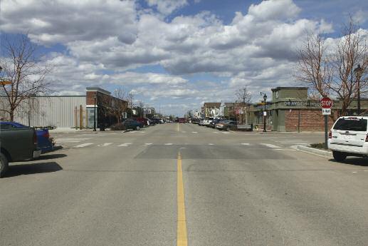
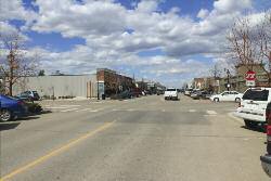
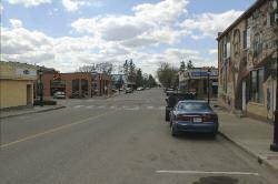
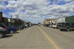
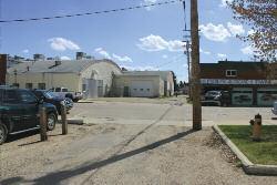
20 2012 Appendix B Photo gallery of images of the Main Street Area, May 2011


21 North Gateway - 49 Avenue & 50 Street (Main Street)


22 South Gateway - 55 Avenue & 50 Street (Main Street)
23 Intersection

24 Centre Island

25 Mid-block Crossing

26 Bike Path & Laneway Crossing
27 Town of Stony Plain Avenue Stony Plain, Alberta T7Z 1Y1 Canada Phone: (780)
appendix and street interface guidelines
 appendix five: building and street interface guidelines appendix 5 building and street interface guidelines BOULEVARDS Boulevards are generally characterized by higher levels of traffic movement at higher
City of Farmington. Downtown Plan. Amendment to the 1998 Master Plan Adopted October 11, 2004
 City of Farmington Amendment to the 1998 Master Plan Adopted October 11, 2004 Introduction Planning Background 1 Scope and Components of the Plan Amendment 2 Concept Introduction 3 Plan Concepts 3 Conceptual
BUSINESS DISTRICT DESIGN GUIDELINES
 Des Plaines, Illinois Prepared for the City of Des Plaines by: The Lakota Group Laurie Marston, AICP March 2005 Section 5: Streetscape Elements Business District Design Guidelines STREETSCAPE ELEMENTS
Policies and Code Intent Sections Related to Town Center
 Policies and Code Intent Sections Related to Town Center The Town Center Vision is scattered throughout the Comprehensive Plan, development code and the 1994 Town Center Plan. What follows are sections
The Project. In 2013, construction was completed between 100 Street and 102 Street.
 The Project Jasper Avenue New Vision (JANV) is a major catalyst project identified in the Capital City Downtown Plan (2010) between 92 Street and 109 Street, including the streets half a block north and
4- PA - LD - LIVELY DOWNTOWN. LD - Background
 4- PA - LD - LIVELY DOWNTOWN LD - Background The downtown has been the service centre for the community since the city s inception and the area continues to supply people with their personal services,
Johnson Street Bridge Public Realm Update
 Johnson Street Bridge Public Realm Update August 20, 2015 Background Johnson Street Bridge Replacement Project impacts a diverse range of stakeholders In addition to a new bridge, the project also includes
Hamilton Road Corridor Streetscape Master Plan. Open House October 4 th, 2017
 Hamilton Road Corridor Streetscape Master Plan Open House October 4 th, 2017 Agenda 1. Introductions Agenda Overview 2. Project Background 3. Existing Conditions 4. Strengths, Weaknesses, Opportunities
Sheridan Boulevard S TAT I O N A R E A P L A N S H E R I D A N B O U L E VA R D S TAT I O N A R E A P L A N
 Sheridan Boulevard S TAT I O N A R E A P L A N 1 City of Lakewood Adopted November, 2006 S H E R I D A N B O U L E VA R D S TAT I O N A R E A P L A N The Vision The City of Lakewood s overall vision is
DRAFT. 10% Common Open Space
 % OF CHARLOTTE IS CATEGORIZED AS A. LAND USES : Placeholder map displaying location of Place Type GOALS: Accommodate XX% of future growth. Provide a concentration of primarily commercial and civic activity
Jewel. Platte. of the. Plattsmouth Main Street Landscape Architecture by HDR
 Jewel of the Platte Plattsmouth Main Street Landscape Architecture by HDR Plattsmouth, Nebraska is a historic community of 6,500 residents located along the west bank of the Missouri River, just south
Town Center (part of the Comprehensive Plan)
") Town Center (part of the Comprehensive Plan) Mercer Island Town Center Looking North (2014) In 1994, a year-long process culminated in a set of design guidelines and code requirements for the Town Center
Town Center (part of the Comprehensive Plan) Mercer Island Town Center Looking North (2014) In 1994, a year-long process culminated in a set of design guidelines and code requirements for the Town Center
Olde Towne Vision Plan
 Olde Towne Vision Plan Introduction In 2016, the City of Bellevue will complete its move of City offices from Olde Towne Bellevue to its new municipal complex on Wall Street. The City intends to sell its
LUNDY S LANE COMMUNITY IMPROVEMENT PLAN STUDY
 PUBLIC INFORMATION MEETING #2 October 12, 2016 LUNDY S LANE COMMUNITY IMPROVEMENT PLAN STUDY AGENDA 5:00 to 5:30pm: Open House 5:30 to 6:15pm: Presentation 6:15 to 7:00pm: Individual paced workshop with
7Page 91 CLEMMONS COMMUNITY COMPASS 7 COMMUNITY CHARACTER
 7 Community Character The beauty of Clemmons won t necessarily be a reflection of our past, but our future. This quote from Comprehensive Plan Steering Committee member Wayne Dodson captures the essence
Conceptual Design. Main Street Enhancement and Extension Project. Bothell, Washington. June 11, 2009
 Conceptual Design Main Street Enhancement and Extension Project Bothell, Washington June 11, 2009 Berger/ABAM Engineers and Cascade Design Collaborative, Inc For Main Street Bothell to succeed it must
Chapter 7: Streetscape & Design Elements
 OVERVIEW Chapter 7: Streetscape & Design Elements During the public input phase of The Dixie Fix, the area of streetscape generated much interest. While safety and traffic flow are primary objectives of
East Bayshore Road Neighbourhood
 East Bayshore Road Neighbourhood Northridge Property Management Urban Design Brief 3195 East Bayshore Road City of Owen Sound January 2016 East Bayshore Road Neighbourhood Northridge Property Management
Ivywild On The Creek PRELIMINARY CREEK DISTRICT MASTER PLAN
 Ivywild On The Creek PRELIMINARY CREEK DISTRICT MASTER PLAN Introduction: Rejuvenating an extraordinary Creekside neighborhood THE CREEKSIDE DISTRICT The Ivywild On The Creek Neighborhood District Master
Lambeth Main Street Streetscape Improvements
 Lambeth Main Street Streetscape Improvements Open House October 5th, 2017 Agenda 1. Introduction 2. Project Background 3. Context 4. Project Objectives 5. Design Principles & Approach 6. Streetscape Design
A. Background Summary of Existing Challenges and Potential Possibilities. 1. Summary of Existing Assets and Potential Opportunities
 A. Background 1 A Main Street Master Plan Study was performed and completed in October of 2007. The study was initiated to review current land uses and development patterns along Main Street, from Parrish
Draft Memorandum #1: Goals and Vision for Revitalization
 Keizer Revitalization Plan Draft Memorandum #1: Goals and Vision for Revitalization Submitted to: City of Keizer April 12, 2018 (revised) Prepared By: Angelo Planning Group and Otak, Inc. Project No. 17482.A
5.1 Site Plan Guidelines
 5. Community Core Guidelines Development of the Community Core will take place by plan of subdivision and site plan approval. It will occur in a phased manner that will reflect the timing of residential
SOUTH UNIVERSITY Street Design Alternatives in Progress
 1 Alternatives in Progress 2016.01.20 Meeting Agenda 2 1. Progress & Schedule 2. Utilizing the Street Design Manual 3. Site Characteristics and Input Received 4. Street Geometry What can we accomplish
EXISTING COMPREHENSIVE PLAN
 EXISTING COMPREHENSIVE PLAN Town Center Land Use Element: V. LAND USE POLICIES Town Center Mercer Island's business district vision as described in "Your Mercer Island Citizen-Designed Downtown" was an
4.9 Mendocino Avenue Corridor Plan Design Guidelines
 4.9 Mendocino Avenue Corridor Plan Design Guidelines The Mendocino Avenue Corridor Plan addresses the area between College Avenue and Steele Lane. Mendocino Avenue is a busy arterial that runs parallel
Municipal Development Plan 2013
 UNIQUELY STONY PLAIN: Municipal Development Plan 2013 Quick Reference Guide What is a Municipal Development Plan (MDP)? The Town s highest-level planning document Sets the long-term vision and key themes
open house 3 CITY OF SALEM Downtown Streetscape Plan
 open house 3 Streetscape concepts CITY OF SALEM Downtown Streetscape Plan analysis concepts we are here refined concepts & document Feb 13th 1 2 3 apr 18th KICKOFF OPEN HOUSE Streetscape Work Group Walking
Lehigh Acres Land Development Regulations Community Planning Project
 Lehigh Acres Land Development Regulations Planning Effort Summary In July, 2010 Commissioner Frank Mann invited the Lehigh Acres community to start discussing how to achieve their recently adopted community
A BLUEPRINT FOR BROCKTON A CITY-WIDE COMPREHENSIVE PLAN
 A BLUEPRINT FOR BROCKTON A CITY-WIDE COMPREHENSIVE PLAN Public Meeting October 2016 1 Plan Summary and Discussion Public Meeting May 4 2017 City of Brockton Bill Carpenter, Mayor Department of Planning
New-Cast Mixed-use Development Proposal King Street West, Newcastle, Ontario
 URBAN DESIGN BRIEF New-Cast Mixed-use Development Proposal King Street West, Newcastle, Ontario TABLE OF CONTENTS: 1.0 Executive Summary 2.0 Creating Vibrant and Sustainable Urban Places: Excerpts from
Attachment 1 TOWN OF NEW TECUMSETH. Manual for the Preparation of an Urban Design Report
 Attachment 1 TOWN OF NEW TECUMSETH Manual for the Preparation of an Urban Design Report July 2010 TABLE OF CONTENTS Background, Policy Framework and the Preparation of Urban Design Reports 1. Introduction
COMPLETE GREEN STREET CHECKLIST
 COMPLETE GREEN STREET CHECKLIST This document was developed to dissect the structure of an urban street and explore opportunities to make our streets more complete while also integrating green street strategies.
Community Design Plan
 Gardena General Plan 2006 Authority While the is not a required element of a General Plan, it is included because improving the community appearance and image is paramount to the overall quality of life
Fifth and Detroit Street Design May 2017 Capital Improvements Committee. DOWNTOWN Street Design
 1 Fifth and Detroit Street Design May 2017 Capital Improvements Committee Agenda 2 Review Street Configuration Prior Meeting Review Outreach Synopsis Functional Street Design Refinements Curb Edge, Turning
GREENING THE BOULEVARD Master Plan Concepts for Venice Boulevard between Lincoln and Sawtelle
 GREENING THE BOULEVARD Katherine Spitz Associates Inc. 4212½ Glencoe Avenue Marina Del Rey, CA 90292 310 574 4460 Fax 574 4462 January 2008 Table of Contents Overview Proposed Design Improvements Illustration
Building Great Neighbourhoods. Strathcona
 Building Great Neighbourhoods Strathcona March 21, 2018 Becky Redford Project Manager, Planning & Design Building Great Neighbourhoods Integrated Infrastructure Services Welcome and Purpose To provide
CHAPTER 3 VISION, GOALS, & PLANNING PRINCIPLES. City of Greensburg Comprehensive Plan. Introduction. Vision Statement. Growth Management Goals.
 CHAPTER 3 VISION, GOALS, & PLANNING PRINCIPLES Introduction The Greensburg Comprehensive Plan is intended as a working community document. A combination of long and short-term goals, this document is intended
Project Goal. RRRC Living Towns Planning Workshp. Town of Halifax Revitalization Project. Dynamic Planning & Management Duo: July 12, 2006
 Project Goal Town of Halifax Revitalization Project RRRC Living Towns Planning Workshp July 12, 2006 Town of Halifax Halifax County *** Revitalization Project Goal*** To create Economic Opportunity and
Burlington Enhancement Plan
 Burlington Enhancement Plan Community Presenta/on Burlington Residents Association East Tennessee Community Design Center The ETCDC is a non-profit that provides low cost, conceptual architectural and
PUBLIC RIGHT-OF-WAY IN THIS CHAPTER PUBLIC REALM
 PUBLIC RIGHT-OF-WAY This section provides design guidelines for improvements in the public right-of-way. The public right-of-way refers to streets, sidewalks, non-vehicular thoroughfares, parks and greenways
VEHICULAR AND PEDESTRIAN CIRCULATION
 This perspective sketch communicates the intended character and quality of a proposed streetscape design. Locate benches near a major intersection where people tend to gather. Seating and lighting provide
PROPOSED REDEVELOPMENT OF THE GLEN ABBEY GOLF CLUB. STREETSCAPE DESIGN STUDY (excerpt from the Urban Design Brief) TOWN OF OAKVILLE.
 TOWN OF OAKVILLE.") PROPOSED REDEVELOPMENT OF THE GLEN ABBEY GOLF CLUB STREETSCAPE DESIGN STUDY (excerpt from the Urban Design Brief) TOWN OF OAKVILLE OCTOBER, 2016 for 2.4.2 STREETS Streets are the single largest component
PROPOSED REDEVELOPMENT OF THE GLEN ABBEY GOLF CLUB STREETSCAPE DESIGN STUDY (excerpt from the Urban Design Brief) TOWN OF OAKVILLE OCTOBER, 2016 for 2.4.2 STREETS Streets are the single largest component
The Vision. Photo provided by The Minervini Group. 46 Vision, Objectives & Strategies
 Vision, Objectives & Strategies The is the public framework and guide for future development of the Grand Traverse Commons. The establishes public polices for infrastructure, the preservation of natural
Table of Contents. Elm Avenue Improvement Plan City of Waco, Texas. Introduction 1. Existing Context 1 Figure 1 2.
 Table of Contents Introduction 1 Existing Context 1 Figure 1 2 Plan Guidelines 3 Future Urban Form 4 The West-End 4 Main Street 6 The East-End 7 Figure 2 9 Public Improvement Recommendations 7 General
Wadsworth Boulevard S TAT I O N A R E A P L A N
 Wadsworth Boulevard S TAT I O N A R E A P L A N City of Lakewood Adopted November, 2006 The Vision The City of Lakewood s overall vision is to transform the area around the light rail station into a mixed-use
THE CIVIC DISTRICT DEVELOPMENT OPPORTUNITIES
 1 THE CIVIC DISTRICT DEVELOPMENT OPPORTUNITIES The Civic District is the physical and emotional heart of the downtown. It is also a major gateway into the central core, establishing the image and identity
6. DOWNTOWN. The Downtown Element focuses on supporting and expanding the vitality and enhancement of Downtown Chico as the City s central core.
 VISION In 2030, Downtown Chico is the heart of the community and the center of cultural activity. Engaging and active at the street level, it is a multi-story, mixed-use hub, with specialty retail, restaurants,
Mark-up of the effect of the proposed Bronte Village Growth Area OPA No.18 on the text of section 24, Bronte Village, of the Livable Oakville Plan
 Mark-up of the effect of the proposed Bronte Village Growth Area OPA No.18 on the text of section 24, Bronte Village, of the Livable Oakville Plan Notes: This document is provided for information purposes
STAFF REPORT Agenda Item: J.4 To: Mayor and City Council Date:
 STAFF REPORT Agenda Item: J.4 To: Mayor and City Council Date: 2-14-2007 Thru: Charles McNeely, City Manager Subject: Staff Report: Approval of a project to be submitted for the NDOT 2007-2009 Landscape
Downtown Whitby Action Plan
 Downtown Whitby Action Plan Final Report October 2016 Table of Contents Introduction 1 Public Consultation 2 Walkability 3 Downtown Whitby Walkability Map 4 Vision 5 Goal & Objectives 6 Objective 1 7 Objective
John M. Fleming Managing Director, Planning and City Planner. Old East Village Dundas Street Corridor Secondary Plan Draft Terms of Reference
 Report to Planning and Environment Committee To: From: Subject: Chair and Members Planning & Environment Committee John M. Fleming Managing Director, Planning and City Planner Old East Village Dundas Street
V. Gateways GATEWAYS / V-1
 V. GATEWAYS / V-1 Many of Chesapeake s gateways are located on highways and call for bold and attractive designs that motorists can understand, appreciate, and enjoy. can also take the form of natural
Downtown North Las Vegas Demonstration Site Project. Project Update
 Downtown North Las Vegas Demonstration Site Project Project Update 7.16.14 Presentation Overview Project Purpose and Process Planning Context Opportunities and Barriers Summary Community Input Preliminary
This Review Is Divided Into Two Phases:
 Semiahmoo Town Centre Review The purpose of this review: To review the Semiahmoo Town Centre Concept Plan, originally approved in 1993, to ensure that this centre will continue to serve the needs of South
C I T Y O F T O R O N T O L A W R E N C E A V E N U E E A S T S T U D Y. Northwest Corner of Birchmount Road and Lawrence Avenue East
 C I T Y O F T O R O N T O A P P E N D I X A Northwest Corner of Birchmount Road and Lawrence Avenue East 92 DILLON CONSULTING LTD. - J.C. WILLIAMS GROUP LTD. APPENDIX B LAWRENCE AVENUE EAST STUDY SUMMARY
Pedestrian and Bike Bridge LOGO
 6.2.2 Pedestrian and Bike Bridge The proposed pedestrian and bike crossing re-envisions the existing bridge at Pismo Creek on Cypress Street. The bridge is currently underutilized by vehicular through
Main Street Reconstruction From Ninth Line to Stouffer Street. Town of Whitchurch-Stouffville. Public Information Centre
 Main Street Reconstruction From Ninth Line to Stouffer Street Town of Whitchurch-Stouffville Public Information Centre November 23, 2016 4:30 to 6:00 pm & 7:00 to 8:00 pm 6240 Main Street, Stouffville
Study Area. Capitol Way. Greening America s Capitals 11/13/2014. A Greening America s Capitals Project
 Olympia, WA: Greening Capitol Way Supporting Communities move towards sustainability is a priority for the federal government. A Greening America s Capitals Project Office of Sustainable Communities U.S.
Complete Neighbourhood Guidelines Review Tool
 Complete Neighbourhood Guidelines Review Tool Prepared By: City of Regina Planning Department October 2014 Page 1 of 14 Community Development Review Checklist for Secondary Plans and Concept Plans The
A. WHAT IS A GENERAL PLAN?
 I. Introduction A. WHAT IS A GENERAL PLAN? A general plan is the planning guideline for the future of a city. It contains goals and policies which regulate urban development, the protection of the natural
Gateway commercial MIXED USE MASTER SITE PLAN. CITILAND AIrDRIE GATEWAY VENTURE INC. airdrie GATEWAY COMMERCE CENTRE. airdrie, ALBERTA FEBRUARY 2012
 Gateway commercial MIXED USE MASTER SITE PLAN 1914 CENTRE STREET NORTH CALGARY, AB CANADA T2E 2S8 T. 403.264.7177 F. 403.264-7175 WWW.CITILAND.CA CITILAND AIrDRIE GATEWAY VENTURE INC. airdrie GATEWAY COMMERCE
Clairtrell Area Context Plan
 Clairtrell Area Context Plan March 2005 Urban Development Services City Planning Contents 1. Introduction... 4 2. Development Structure... 6 2.1 Streets... 7 2.1.1 Sheppard Avenue and Bayview Avenue...
SAN RAFAEL GENERAL PLAN 2040 INTRODUCTION AND OVERVIEW
 SAN RAFAEL GENERAL PLAN 2040 INTRODUCTION AND OVERVIEW Steering Committee Presentation February 14, 2018 Purpose of General Plan Guide land use and development decisions Coordinate transportation, infrastructure,
Public input has been an important part of the plan development process.
 Lakewood s Comprehensive Plan recognizes that transportation helps shape the community, and that the way the community provides for the safe and efficient movement of people affects the character of the
Potential Green Infrastructure Strategies May 6, 2015 Workshop
 Potential Green Infrastructure Strategies May 6, 2015 Workshop Background The City of Cortland is developing the Tioughnioga Urban Headwaters Green Infrastructure Action Plan with funding from the National
Port Lavaca Future Land Use
 Port Lavaca Future Land Use Introduction The City of Port Lavaca is beginning to see sustained growth, after many years of relative stable population. New single family homes, apartments, and businesses
Urban Design Manual PLANNING AROUND RAPID TRANSIT STATIONS (PARTS) Introduction. Station Study Areas
 Introduction. Station Study Areas") 111111 PLANNING AROUND RAPID TRANSIT STATIONS (PARTS) Introduction The ION rapid transit system will link Waterloo, Kitchener and Cambridge through a central transit corridor (CTC). There are a number
111111 PLANNING AROUND RAPID TRANSIT STATIONS (PARTS) Introduction The ION rapid transit system will link Waterloo, Kitchener and Cambridge through a central transit corridor (CTC). There are a number
Visioning Statement and Guiding Principles
 Visioning Statement and Guiding Principles Planning for the Future The General Plan The General Plan represents Woodland's shared vision of the future and defines a path to lead the community toward its
TORONTO COMPLETE STREETS GUIDELINES
 TORONTO COMPLETE STREETS GUIDELINES Presentation by Fiona Chapman, Manager, Pedestrian Projects Public Realm Section, Transportation Services, City of Toronto June 2017 PURPOSE OF THE PROJECT To develop
2136 & 2148 Trafalgar Road Town of Oakville Region of Halton
 PLANNING JUSTIFICATION REPORT 2136 & 2148 Trafalgar Road Town of Oakville Region of Halton Zoning By-Law Amendment Application 2500674 Ontario Inc. November 2016 Table of Contents Page 1.0 Location/Summary
Dyersville Downtown Plan. Open House October 24, 2017
 Dyersville Downtown Plan Open House October 24, 2017 What is a Comprehensive Plan? - Vision - Guidance for decisions - Basis for regulations What is a Downtown Plan? - Understand priorities - Identify
Downtown Papillion. Concepts for the Enhancement and Growth of Papillion s Traditional Town Center
 Downtown Papillion Concepts for the Enhancement and Growth of Papillion s Traditional Town Center Developed for the City of Papillion by RDG Planning & Design T raditional downtown districts occupy a particular
Community Assistantship Program. Milaca Downtown Revitalization
 Community Assistantship Program Milaca Downtown Revitalization Prepared in partnership with City of Milaca Prepared by Zachary Jorgensen Research Assistant University of Minnesota December, 2009 CAP Report
38 Queen s University Campus Master Plan Part 1
 38 Queen s University Campus Master Plan Part 1 46 The Campus at the City Scale Chapter 4 The Campus at the City Scale 39 Queen s is an urban University centrally located in Kingston. Decisions made by
Sierra Springs Regional Commercial Master Site Plan Airdrie, Alberta Hopewell Development Corporation Project No May 26, 2010
 Sierra Springs Regional Commercial Master Site Plan Airdrie, Alberta Hopewell Development Corporation Project No. 205-077 May 26, 2010 TABLE OF CONTENTS Purpose... 2 Master Site Plan Guidelines... 3 Overall
Figure Example of out door dining in the public right-of-way.
 Section 2 Core Area Goal 2.2.1 To maintain and enhance the character of existing streets in the Downtown Area. Character Figure 2.2.1 Example of out door dining in the public right-of-way. A. Provide street
DOWNTOWN GEORGETOWN PLANNING STUDY
 DOWNTOWN GEORGETOWN PLANNING STUDY Community Workshop #3 Thursday, May 4, 08 The Planning Partnership OVERVIEW OF STUDY, PROCESS & MILESTONES We are here PURPOSE OF THE STUDY To develop a clear vision
URBAN DESIGN BRIEF REPORT
 URBAN DESIGN BRIEF REPORT PREPARED FOR 2568401 ONTARIO INC NEW GASBAR, CONVENIENCE STORE & CARWASH DEVELOPMENT @ 1509 FANSHAWE PARK ROAD WEST LONDON, ONTARIO GAMA ENGINEERING INC. PROJECT NUMBER 1669 PREPARED
McCowan Precinct Plan Study Background & Deliverables
 1 DRAFT & WITHOUT PREJUDICE McCowan Precinct Plan Study Background & Deliverables In September, 2011, City Planning (Scarborough District) began a study of an area within the Scarborough Centre, identified
Design Considerations
 Essential to the development of a successful Master Plan for the Park Complex is input from the community that the park will serve. The community outreach component of the planning process included numerous
Status Update (2006 vs. Now) Citizen s Advisory Committee February Plan for Prosperity
 Citizen s Advisory Committee February Plan for Prosperity") Status Update (2006 vs. Now) Citizen s Advisory Committee February 2018 Plan for Prosperity 2000 2017 2000 2017 Gardnerville Population 6,000 5,760 5746 5,500 5,000 5,067 5,550 5,165 5,394 5,412 5,250
Status Update (2006 vs. Now) Citizen s Advisory Committee February 2018 Plan for Prosperity 2000 2017 2000 2017 Gardnerville Population 6,000 5,760 5746 5,500 5,000 5,067 5,550 5,165 5,394 5,412 5,250
City of Plattsburgh DRI: Downtown Streetscapes & Riverfront Access. Downtown Streetscape and Riverfront Access Design
 City of Plattsburgh DRI: Downtown Streetscapes & Riverfront Access Welcome Thank you for coming this evening. Agenda PART I - Project Context The Downtown Revitalization Program Our DRI Projects Other
1.0 Purpose of a Secondary Plan for the Masonville Transit Village
 Report to Planning and Environment Committee To: Chair and Members Planning & Environment Committee From: John M. Fleming Managing Director, Planning and City Planner Subject: Masonville Transit Village
Report to: Development Services Committee Report Date: April 24, 2017
 SUBJECT: Cornell Rouge National Urban Park Gateway - Report on Design Charrette and Next Steps PREPARED BY: Lilli Duoba, MES, MCIP, RPP, Manager, Natural Heritage (ext. 7925) REVIEWED BY: Marg Wouters,
INSTITUTIONAL USE DESIGN COMPATIBILITY TECHNIQUES
 INSTITUTIONAL USE DESIGN COMPATIBILITY TECHNIQUES INTRODUCTION Community institutions are an important part of the character and vitality of neighborhoods in Forsyth County. Institutional uses include
Today Land & People. Northeast Nampa Gateway District. Employment. Land Use Characteristics. Demographics. Current Zoning
 Today Land & People Employment Major employers include Saint Alphonsus, the College of Western Idaho, the Auto Mall, Sorrento Lactalis and Walmart. 3,004 jobs in 2010 (COMPASS-CIM 2040 TAZ data) 4,345
PLAN ELEMENTS WORKSHOP. April 5, 2016
 PLAN ELEMENTS WORKSHOP April 5, 2016 needs more housing. But there is no one-size fits-all solution. Every neighborhood has its own character. In some places, density is not only appropriate it is badly
About Momentum Midland
 About Momentum Midland Achieving a community s full potential in terms of economic development and quality of life is critically important to its long term sustainability. Core to achieving this is a vibrant
Welcome to the Oakridge Centre Open House
 Welcome to the Oakridge Centre Open House Why is the City hosting this event? This open house is to inform you of a rezoning application submitted to the City of Vancouver to amend the existing CD-1 (Comprehensive
Toronto Complete Streets Guidelines
 Toronto Complete Streets Guidelines 108 110 7.1 Green Infrastructure Design Principles 112 7.2 Context-Sensitive Green Streets 114 7.3 Key Green Street Elements Green infrastructure refers to natural and
1. General Purpose. 3. Uses
 1. General Purpose The purpose of this DC1 Provision is to facilitate the development of a pedestrian friendly Community Commercial Centre that may accommodate a range of commercial, residential, office,
Town of Cobourg Heritage Master Plan. Statutory Public Meeting
 Town of Cobourg Heritage Master Plan Statutory Public Meeting April 25 th 2016 Presentation Overview 1. Introduction 2. Project background and schedule overview 3. Review of strategic direction content
Welcome. Community Consultation Meeting November 28, Review and discuss the Bathurst Quay Neighbourhood Plan Framework
 Welcome Community Consultation Meeting November 28, 2016 Why Are We Here Today? Review and discuss the Bathurst Quay Neighbourhood Plan Framework Review and discuss an Action Plan for Implementation Next
The Village. Chapter 3. Mixed Use Development Plan SPECIFIC PLAN
 The Village SPECIFIC PLAN Chapter 3 3.1 INTRODUCTION 3.1.1 Purpose This Chapter describes the development regulations applicable to the Mixed-Use and Transit Center Planning Areas. These form-based regulations
ARLINGTON COUNTY, VIRGINIA
 ARLINGTON COUNTY, VIRGINIA County Board Agenda Item Meeting October 15, 2005 DATE: September 28, 2005 SUBJECT: Request to Advertise the adoption of the 2005 Clarendon Sector Plan C. M. RECOMMENDATION:
Lower Merion Commercial Districts Issues and Characteristics Handbook November 2013
 Lower Merion Commercial Districts Issues and Characteristics Handbook November 2013 DRAFT TOWNSHIP-WIDE VISION: To maintain and enhance commercial areas to complement the surrounding high-quality residential
(DC1) Direct Development Control Provision DC1 Area 4
 Direct Development Control Provision DC1 Area 4") . General Purpose (DC) Direct Development Control Provision DC Area 4 The purpose of this Provision is to provide for an area of commercial office employment and residential development in support of the
. General Purpose (DC) Direct Development Control Provision DC Area 4 The purpose of this Provision is to provide for an area of commercial office employment and residential development in support of the
Maplewood Avenue Downtown Complete Street Project
 Maplewood Avenue Downtown Complete Street Project Second Public Meeting January 24, 2018 Welcome and Introduction of Project Team City Planning and Public Works Staff City of Portsmouth Juliet Walker Planning
THE GARDEN CITY PLAN. City of St. Catharines Official Plan. City of St. Catharines
 THE GARDEN CITY PLAN City of St. Catharines Official Plan City of St. Catharines August 2010 APPROVAL INFORMATION This Official Plan of the City of St. Catharines Planning Area, known as the Garden City