TOWN OF BETHLEHEM OPEN SPACE CONSERVATION PLAN PUBLIC MEETING: OCTOBER 12, 2017
|
|
|
- Gervase Rice
- 5 years ago
- Views:
Transcription


1 TOWN OF BETHLEHEM OPEN SPACE CONSERVATION PLAN PUBLIC MEETING: OCTOBER 12, 2017

2 Welcome and Agenda 6:00 6:45: Open House, Part One 6:45 7:15: Presentation and Questions 7:15 8:00: Open House, Part Two Open House Stations include: Open Space Values Maps, Conservation Criteria, and Draft Conservation Priority Areas Map Open Space Scenic Views Photo Survey Bethlehem s Conservation Tools Natural Areas and Wildlife in Bethlehem Comments, questions, suggestions: Comment Box Bethlehem Public Library display: month of November. OpenSpace@townofbethlehem.org Thank you for coming tonight!
- 2007 Recommended creation of a Farm and")
 - 2013 Develop criteria for land protection and acquisition to be used by the Town Board purchasing or accepting land for open space preservation Conservation Easement")
3 Background Comprehensive Plan 2005 Develop an Open Space program Citizens Advisory Committee on Conservation (CACC) est Funding and Tools Report Identified potential criteria for establishing land preservation priorities Comprehensive Plan Oversight Committee (CPOC) Recommended creation of a Farm and Open Space Protection Program CACC Report on Open Space 2009 Recommendation 12: Develop land feature criteria to rate preservation opportunities Agriculture and Farmland Plan 2009 Comprehensive Plan Assessment Committee (CPAC) Develop criteria for land protection and acquisition to be used by the Town Board purchasing or accepting land for open space preservation Conservation Easement Review Board est Administer the Conservation Easement Exemption Program Advisory on current open space planning work

4 Finding the Balance The purpose of open space planning is to ensure that future consumption of land for development is balanced with the conservation of land for its open space value CACC Report on Open Space Formally, open space resources include public and private parks and preserves, recreation areas and dedicated conservation lands (about 2,070 acres or 7% of the Town s total area). More informally, open space resources also include its undeveloped wetlands, floodplains, water bodies, tidal areas, wildlife habitats, steep slopes, forests, fields and agricultural lands. Over the years, the Town has lost a good deal of its open space to the development of housing, industry, commerce and other land uses, many of which support and add value to the community. Most of these remaining open space resources are held in private ownership.

5 Purpose Voluntary participation with interested landowners will be necessary if the Town is to conserve an open space system of any substance. Conservation partnerships should result in a mutual benefit to both the landowner and Town. Open space planning does not aim to stop or curtail development activity, or to limit or curtail the rights of private landowners. The conservation of open space resources is essential if the Town is to maintain critical natural systems, the character of the community, its quality of life, property values, and recreation opportunities for Town residents.


6 Benefits of Open Space Natural systems services Clean water, clean air, temperature cooling, farming, forestry, flood reduction Cost savings, less need for engineered fixes Wildlife habitat, biodiversity Open land costs town less than residential/commercial uses: Cost of community services studies Public health water quality, air quality, scenic beauty, local food, recreation Community character forests, farmland, diversity in landscape, connection to history, recreation opportunities, quality of life Decreased wildlife/human conflicts

7 Prioritizing Open Space Several prior Town open space initiatives recommended development of conservation criteria Nine other NYS towns who have completed similar open space conservation priority analyses to develop the best conservation criteria and method of analyzation applicable to Bethlehem.


8 PROJECT SCOPE Phase 1 Inventory Mapping / Conservation Values Maps 1. Open Space Resources Inventory Mapping Conservation Values Maps 2. Review/Discuss with Conservation Easement Review Board Throughout Spring/Summer/Fall Presentation to Town Board June 14th meeting/august 23 rd meeting 4. Public Engagement and Outreach Scenic Bethlehem Photo Survey, Delmar Farmers Market, Hudson Kayak Eco-tour, Bethlehem Library display, website postings, newsletters, etc.

9 CONSERVATION VALUES MAPPING Identification of Existing Conditions Geographic Information Systems-based (GIS) process to efficiently evaluate overlap of multiple conservation values and resources resulting in the Open Space Plan Data collected from over 20 public data sources and the Town More than 70 datasets evaluated


10 CONSERVATION VALUES MAPPING Conservation Value: Community Character Conservation Value: Recreation and Greenways Conservation Value: Natural Water Systems Streams, Wetlands and the Hudson River Conservation Value: Forest, Fields and Wildlife Systems


11 VALUE: COMMUNITY CHARACTER Agricultural landscapes National Register Structures/Districts Cultural/Educational places Nature preserves and parks

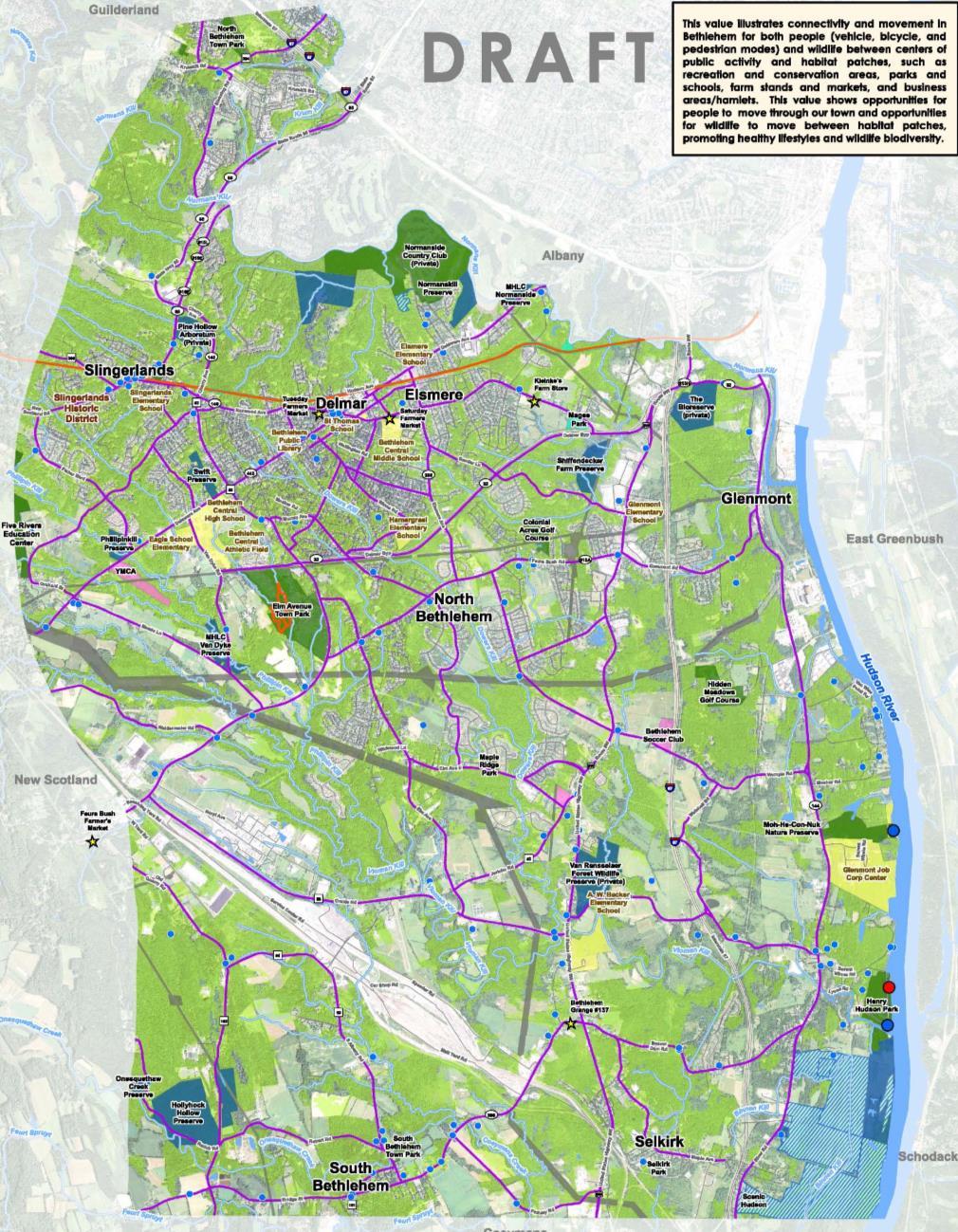
12 VALUE: RECREATION & GREENWAYS Linkages/Connectivity (people & wildlife) Nodes Recreation areas Conservation areas Schools Habitat patches


13 VALUE: NATURAL WATER SYSTEMS Aquatic biodiversity Water quality Estuary ecosystem Floodzones Public health


14 VALUE: FORESTS, FIELDS & WILDLIFE Forest patches Biodiversity Areas Air/water quality Floodzones Rare Plants/Animals Croplands


15 CONSERVATION VALUES MAPPING GIS-based process to efficiently evaluate overlap of multiple conservation criteria based on existing conditions Result will help inform the Open Space Plan and conservation priorities Data collected will be input into a Conservation Analysis Tool to identify conservation priority areas town-wide 25 Conservation Criteria data driven, scientifically based, objective

16 PHASE 2 OPEN SPACE PLAN 1. Public Meetings October Meeting #1 Public review/discussion on Conservation Values Maps Feedback and GIS-based model leads to Open Space Plan November Town Board Presentation Meeting #2 To Be Determined 2. Open Space Plan, including Open Space Priorities Map Conservation Analysis Tool to develop Open Space Priorities Map Open Space Plan
17 CONSERVATION ANALYSIS TOOL - METHODOLOGY


18 CONSERVATION ANALYSIS TOOL What: GIS-based model created to efficiently evaluate overlap of multiple conservation values and resources How: Identify Model Inputs Determine Preservation Priority Score Significant High Moderate Map/Illustrate Results Result: Composite Map Illustrating Conservation Priority Areas within the Town to be used as a tool for town and interested land owners


19 CONSERVATION ANALYSIS TOOL Conservation Criteria 25 criteria applied to lands 5 acres or greater including vacant, residential with large acreage and agricultural land Model Run A property receives a 1 for each criteria it meets The more criteria met, the higher the numerical score ranging from 0 25 Results categorized as moderate, high or significant based on numerical score and mapped
20 CONSERVATION ANALYSIS TOOL Sample of Conservation Criteria (see handout for full list) Adjacent to preserves/conserved lands Contains designated trout stream/migratory fish run Adjacent or containing parkland or outdoor recreation Adjacent to town conservation easements Adjacent to bike/ped priority network Contains registered historic structure or district Contains wetlands Contains or connected to large forest patch Contains Significant Biodiversity Area Contains areas important for rare plants or animals Contains active agricultural lands Contains prime farmland soils Within floodplain Contains soils with high erosion potential or steep slopes


21 CONSERVATION ANALYSIS TOOL DRAFT Conservation Priority Areas This map does not direct the town to take any proactive action on lands Intended to assist the town when a landowner expresses interest in conservation

22 How will we use the Open Space Conservation Priority Areas Map?

23 Current Conservation Opportunities Conservation Easement Exemption If a private landowner, with 5 acres or more, is interested in conservation and cost-savings. Development review Conservation Subdivision and Planned Development Districts clustering of units, variety of housing types and density incentives in exchange for open space conservation. Future Conservation Opportunities Land sale If land that is considered conservation priority is for sale, town can consider purchase. Purchase of Development Rights If private landowner is interested in conservation and financial savings, town (or a partnership) could consider purchase of development rights (PDR), while landowner retains ownership. Both of these opportunities would require a substantial dedicated funding mechanism and partnerships (with state, federal and local entities and land trusts). Every conservation opportunity is unique Multiple tools to accommodate diverse circumstances. Through the implementation options both parties would see a mutual benefit. Voluntary participation with interested landowners will be necessary if the Town is to conserve an open space system of any substance. Implementation
 3 under review Tilroe Salisbury Road approved Scenic Hudson")
24 Implementation examples Van Dyke Preserve- partnership with MHLC, Town, and developer PDD -senior apartments and 33 acre preserve set-aside Newell Conservation Subdivision 40 lots on Wemple, resulted in 16 acres preserved in vicinity of Dowerskill 9 lots at end of Egmont Court Conservation Easement Exemption (15 inquiries/1 approved) 3 under review Tilroe Salisbury Road approved Scenic Hudson Baker Farm purchase (155 acres) and Jennings conservation easement

25 NEXT STEPS
26 NEXT STEPS Gather Input from Public Tonight Refine Conservation Values Mapping Refine Conservation Analysis Tool Presentation to Town Board November 8, 2017 Public display of maps and materials at Bethlehem library in November Develop Open Space Plan
27 QUESTIONS/COMMENTS
28 THANK YOU
Town of Peru Comprehensive Plan Executive Summary
 Town of Peru Comprehensive Plan Executive Communities that plan grow by choice, not by chance. A plan makes growth thoughtful, understandable, and predictable. A plan shows that a community is managing
Community Conservation Workshop. Lake Placid
 Community Conservation Workshop Lake Placid 2 Community Conservation Program Welcome! We have designed a Community Conservation Program that listens to the needs of community members. We are conducting
Community Conservation Workshop. Saranac River Basin Communities
 Community Conservation Workshop Saranac River Basin Communities 2 Community Conservation Program Welcome! We have designed a Community Conservation Program that listens to the needs of community members.
Riparian Buffer on the Bushkill Creek. Policies
 Riparian Buffer on the Bushkill Creek Riparian buffers provide numerous benefits to landowners and the community by protecting groundwater recharge areas, providing flood control, providing stormwater
It Takes A Village.. Preserving Rural Character In Standish
 It Takes A Village.. Preserving Rural Character In Standish A Public Workshop Hosted by Conservation and Open Space Plan Committee & Standish Corner Village Implementation Committee June 12, 2008 Desired
STEWARDSHIP OF LONG ISLAND SOUND S ECOLOGICAL AND RECREATIONAL RESOURCES
 STEWARDSHIP OF LONG ISLAND SOUND S ECOLOGICAL AND RECREATIONAL RESOURCES Robin Kriesberg, Save the Sound, Inc. Thomas Halavik, US Fish and Wildlife Service Coastal Program An Initiative to Identify, Protect
Countywide Green Infrastructure
 Montgomery County s Countywide Green Infrastructure F U N C T I O N A L M A S T E R P L A N The Maryland National Capital Park and Planning Commission INFRASTRUCTURE An underlying base or foundation especially
Green Infrastructure Policies and Ordinances
 Green Infrastructure Policies and Ordinances October 23, 2013 By Karen Firehock, Green Infrastructure Center 2013 Georgia Urban Forest Council s 23 rd Annual Conference The mission of the nonprofit Green
TOWN OF BETHLEHEM MEETING SUMMARY LOCAL WATERFRONT REVITALIZATION PROGRAM UPDATE
 TOWN OF BETHLEHEM LOCAL WATERFRONT REVITALIZATION PROGRAM UPDATE MEETING SUMMARY Purpose: LWRP Update Public Workshop #3 Date and Time: October 24, 2017, 6:00 pm - 8:00 pm Location: Town Hall, 445 Delaware
Planning for Staten. Habitat Restoration and Green Infrastructure. Island s North Shore
 Habitat Restoration and Green Infrastructure Planning for Staten Island s North Shore Community Board 1 March 1, 2018 NYC Parks Forestry, Horticulture, and Natural Resources Funded by the NYS Department
CHAPTER 4 FUTURE LAND USE AND URBAN SERVICES DISTRICTS
 CHAPTER 4 FUTURE LAND USE AND URBAN SERVICES DISTRICTS Introduction This chapter discusses how Benzie County should grow and change in the future. A community can grow and change in many different ways.
The City shall enhance and improve the accessibility of parks and recreational facilities while protecting their quality. by:
 GOALS, OBJECTIVES AND POLICIES GOAL 1: To provide open space and recreation as an essential element needed for the betterment of the City s character and quality of urban life. The City shall plan for
City of Missoula and Missoula County Open Space Planning Open House
 City of Missoula and Missoula County Open Space Planning Open House FEBRUARY 6, 2018 The following slides contain the display board content from the open house. Please use boards to answer questions in
Whitemarsh Township Greenway Plan
 Whitemarsh Township Greenway Plan Prepared for: Whitemarsh Township August 16, 2007 Table of Contents Table of Contents... i Introduction... 1 Study Area Setting... 2 Regional Setting... 2 Township Character...
TOWN OF SPRINGFIELD, NEW HAMPSHIRE
 TOWN OF SPRINGFIELD, NEW HAMPSHIRE NATURAL RESOURCES INVENTORY EXECUTIVE SUMMARY March 2008 Prepared by: Watershed to Wildlife, Inc. Natural Resource Consultants 42 Mill Street, Suite 3 Littleton, NH 03561
RECREATION, OPEN SPACE AND GREENWAYS ELEMENT GOALS, OBJECTIVES, AND POLICIES
 RECREATION, OPEN SPACE AND GREENWAYS ELEMENT GOALS, OBJECTIVES, AND POLICIES GOAL R-1: DEVELOP A RECREATION, OPEN SPACE AND GREENWAYS SYSTEM AS AN INTEGRAL COMPONENT OF AN OVERALL, COUNTY-WIDE ECONOMIC
Green Infrastructure. by Karen Engel, NYS DEC. NYS Department of Environmental Conservation
 Green Infrastructure by Karen Engel, NYS DEC What is Green Infrastructure? For some it s all about water Green Infrastructure techniques use soils and vegetation to infiltrate, evapotranspirate, and/or
National Association of Conservation Districts. Kris Hoellen Vice President, Sustainable Programs The Conservation Fund September 19, 2013
 National Association of Conservation Districts Kris Hoellen Vice President, Sustainable Programs The Conservation Fund September 19, 2013 Our Mission The Conservation Fund forges partnerships to conserve
Provide and maintain sufficient public parks, recreation facilities, and open space to meet the recreational needs of County residents and visitors.
 (ROS) Goal Provide and maintain sufficient public parks, recreation facilities, and open space to meet the recreational needs of County residents and visitors. OBJECTIVE ROS.01 The County shall acquire,
OPEN SPACE CHAPTER 7: OVERVIEW. Preserve open space to protect natural resources, enhance character and provide passive recreation opportunities
 CHAPTER 7: OPEN SPACE OVERVIEW Ridgefield has made tremendous progress permanently preserving areas of town as open space. Open space preservation can serve many important purposes, including: protect
I. STAFF POLICY RECOMMENDATIONS. The following RMP policy strategies are proposed by staff in support of a Scenic Resource Protection Program:
 Policy Consideration: Scenic Resource Protection Program Status: For Consideration by the Highlands Council at September 14, 2006 Work session Date: September 12, 2006 I. STAFF POLICY RECOMMENDATIONS The
Town of Bethlehem. Recommendations on Open Space Needs and Opportunities
 Prepared by the Town of Bethlehem Department of Economic Development and Planning Behan Planning and Design In association with Citizens Advisory Committee on Conservation Libby Liebschutz, Chairman Jeff
Regional Open Space Conservation Plan. Regional Staff Committee January 18, 2018
 Regional Open Space Conservation Plan Regional Staff Committee January 18, 2018 Schedule We are here Task 1 - Stakeholder Input & Work Plan Dev. v z 2016 2017 2018 Oct Nov Dec Jan Feb Mar Apr May Jun Jul
Planning for and Managing Open Space and Natural Areas
 Planning for and Managing Open Space and Natural Areas Increasingly, development proposals in Delaware include large amounts of open space and natural areas. While open space is important as a community
Executive Summary Purpose of the Plan Defining Open Space and Greenways
 Executive Summary Bucks County possesses a vast array of open space resources including natural areas, parks, farmland and historic and cultural resources that contribute to a high quality of life valued
Oakland County s Green Infrastructure Vision. L. Brooks Patterson Oakland County Executive
 Oakland County s Green Infrastructure Vision L. Brooks Patterson Oakland County Executive Southeast Michigan 20 miles northwest of Detroit Consists of 910 square miles Population of 1.2 million More than
This page intentionally blank.
 This page intentionally blank. Parks, Recreation, and Open Space Chapter Relationship to Vision Vision Parks, Recreation and Open Space Chapter Concepts County Government. County government that is accountable
Blue/Green Infrastructure Study Accomack County, VA
 Blue/Green Infrastructure Study Accomack County, VA Draft Asset Maps March 8-9, 2010 Green Infrastructure Center, Inc. 2 Overview What is Green and Blue Infrastructure Project Timeline & Tasks Literature
Shared History, Shared Future
 Open Space is Shared History, Shared Future Builds upon past and current regional planning: PSP Action Agenda, Vision 2040, the Cascade Agenda, and Mountains to Sound Greenway The ROSS Approach Building
Brice Prairie Master Plan
 Brice Prairie Master Plan Town of Onalaska Community Meeting #1 Sand Lake Elementary School January 28, 2006 9 am 11 am Agenda Background What is a Master Plan? Brice Prairie Capacity Reports Starter Ideas
Conservation Corridor Base and Thematic Maps
 Conservation Corridor Base and Thematic Maps August 20, 2010 This project is funded in part by the Virginia Coastal Zone Management Program at the Department of Environmental Quality through Grant #NAO9NOS4190163
Town of Liberty, NY COMPREHENSIVE PLAN & ZONING UPDATES
 Town of Liberty, NY S Public Informational Meeting October 4, 2016 High School Auditorium Welcome Thank you for coming tonight. Agenda Part I Overview of Proposed Changes What is Being Prepared Anticipated
Town of Washington Master Plan & Regulatory Audit: Interim Results
 Town of Washington Master Plan & Regulatory Audit: Interim Results May 20, 2008 Presented by: 30 Bank Street Lebanon, NH 03766 www.uvlsrpc.org Introduction & Purpose Compare the Master Plan to the regulations
Sorted citizen input comments in review of Blount County plans July, August, and September 2007
 Sorted citizen input comments in review of Blount County plans July, August, and September 2007 The following presents sorted citizen input comments from three sessions held in July, August and September
Parks, Trails, and Open space Element
 Parks, Trails, and Open space Element Parks, Trails, and Open Space element Parks, Recreation, and Open Space are important components of the quality of life desired by the residents of Elk Grove. This
Minnesota Department of Natural Resource - Natural Resource Guidance Checklist Conserving Natural Resources through Density Bonuses
 Minnesota Department of Natural Resource - Natural Resource Guidance Checklist Conserving Natural Resources through Density Bonuses NRDB Why Use Density Bonuses & This Checklist Local units of government
INTRODUCTION Key Issues and Findings Goals, Objectives, and Policies - Natural Resources - Map M18 - Environmental Resources
 Natural, Environmental, Cu INTRODUCTION This Element provides policies related to the preservation and protection of the Centre Region s natural, environmental, cultural, and historic resources. This Element
SALISBURY TOMORROW Our Vision
 SALISBURY TOMORROW Our Vision Salisbury is committed to supporting a high quality of life and sense of community for all residents. These commitments need to be reflected in our community programs, services
Photo by Carlton Ward Jr. Executive Summary
 Photo by Carlton Ward Jr. Executive Summary The Cooperative Conservation Blueprint (Blueprint) is a multi-partner strategic conservation process developed by the Florida Fish and Wildlife Commission (FWC)
Conservation Corridor Planning and Green Infrastructure Themes
 Conservation Corridor Planning and Green Infrastructure Themes Prepared by the Green Infrastructure Center Inc. and the Northern Virginia Regional Commission February 22, 2011 Brief Overview Project Background
Stream Corridor Management Plan
 Stream Corridor Management Plan A unified and comprehensive approach to protecting, restoring and managing the Upper Delaware River Graydon Dutcher Delaware County Soil and Water Conservation District
6.0 Conclusions & Recommendations
 6.0 Conclusions & Recommendations 75 The research, public outreach and feasibility analysis completed for this study indicate that Trail Alternative #2 (South side of Doctors Creek) is the most comprehensive
Parks, Trails, and Open Space Element
 P arks, Recreation, and Open Space are important components of the quality of life desired by the residents of Elk Grove. This Element of the General Plan addresses the City s goals, policies, and actions
Preface. Erie. Scranton. Allentown. Pittsburgh. Harrisburg. Philadelphia
 The Southern Alleghenies Region The Southern Alleghenies Region spans the Laurel Highlands and Allegheny Front in the west across the Appalachians to the east. It is comprised of Blair, Bedford, Cambria,
Town of Lyons Parks Flood Recovery Planning Process. Photograph courtesy of Ed Bruder
 Town of Lyons Parks Flood Recovery Planning Process Photograph courtesy of Ed Bruder Lyons Parks and Recreation Flood Recovery Update 1. Meadow Park Phase II - Project PW20B1 Estimated Completion: Summer
Overview of Southwestern Pennsylvania Commission s (SPC) 2040 Long Range Transportation Plan (LRTP)
 2040 Long Range Transportation Plan (LRTP)") Overview of Southwestern Pennsylvania Commission s (SPC) 2040 Long Range Transportation Plan (LRTP) Presented to Pennsylvania Agency Coordination Meeting May 27, 2015 Doug Smith & Ryan Gordon 1 Southwestern
Overview of Southwestern Pennsylvania Commission s (SPC) 2040 Long Range Transportation Plan (LRTP) Presented to Pennsylvania Agency Coordination Meeting May 27, 2015 Doug Smith & Ryan Gordon 1 Southwestern
RECREATION AND OPEN SPACE ELEMENT GOALS, OBJECTIVES, AND POLICIES
 RECREATION AND OPEN SPACE ELEMENT GOALS, OBJECTIVES, AND POLICIES GOALS, OBJECTIVES AND POLICIES GOAL 1: TO PROVIDE A FULL RANGE OF RECREATIONAL ACTIVITIES THAT ARE ACCESSIBLE, COMPATIBLE AND CONTINUOUS
Rural Land Use Designations Kittitas County December 6, 2007 Draft
 KITTITAS COUNTY COMMUNITY DEVELOPMENT SERVICES 411 N. Ruby St., Suite 2, Ellensburg, WA 98926 CDS@CO.KITTITAS.WA.US Office (509) 962-7506 Fax (509) 962-7682 Rural Land Use Designations Kittitas County
PUBLIC SPACES MASTER PLAN UPDATE (POPS) Joint Facilities Advisory Commission (JFAC) November 28, 2018
 Joint Facilities Advisory Commission (JFAC) November 28, 2018") PUBLIC SPACES MASTER PLAN UPDATE (POPS) Joint Facilities Advisory Commission (JFAC) November 28, 2018 1 AGENDA POPS Planning Context Timeline Public Input Final POPS Draft Next Steps 2 PLANNING CONTEXT
PUBLIC SPACES MASTER PLAN UPDATE (POPS) Joint Facilities Advisory Commission (JFAC) November 28, 2018 1 AGENDA POPS Planning Context Timeline Public Input Final POPS Draft Next Steps 2 PLANNING CONTEXT
Memorandum Planning. Thursday, January 8, 2015
 Memorandum Planning Thursday, January 8, 2015 7.A. To: Coastal Advisory Committee From John Ciampa, Associate Planner Subject: Review Draft Local Coastal Program Copies: James Pechous, City Planner Purpose
1. Parks & Recreation Neighborhood Parks Community Parks Special Use Sites 2. Open Space 3. Trails
 Appendix A: Park Classifications The intent of parks and recreation classifications is to aid in making acquisition and design decisions for park sites, facilities and the organization of recreation space
DRAFT MAP AMENDMENT FLU 04-4
 DRAFT MAP AMENDMENT FLU 04-4 SW 24 TH AVENUE ROADWAY CORRIDOR The University of Florida participates with the Metropolitan Transportation Planning Organization (MTPO) in its responsibilities for the continuing,
Sustainable Keuka Lake
 Sustainable Keuka Lake Steve Butchko, Town of Wayne Supervisor Chelsea Robertson, Senior Planner STC Kemberli Sargent, Planner STC www.sustainablekeuka.net This presentation was prepared for the New York
MAYFIELD WEST SECONDARY PLAN PHASE 2
 MAYFIELD WEST SECONDARY PLAN PHASE 2 Public Open House #3 February 25, 2010 Draft Preferred Land Use Scenario TOWN OF CALEDON PLANNING & DEVELOPMENT DEPARTMENT Open House Agenda TOWN OF CALEDON 1. Welcome
TOWN OF BEDFORD CONSERVATION COMMISSION
 PUBLIC NOTICE DRAFT Work Plan The is in the process of forming a subcommittee that will be studying the of Exceptional Value and their importance to the Town of Bedford. This document will serve as the
Whitemarsh Comprehensive Plan Update: Housing & Land Use. Public Workshop #3: September 20, 2018
 Whitemarsh Comprehensive Plan Update: Housing & Land Use Public Workshop #3: September 20, 2018 Agenda Welcome Process Recap What We ve Heard The Plan Framework Review of Recommended Actions Land Use Housing
Arkansas River Corridor
 Planning for Access Welcome to the Access Project. This project is a recreational planning effort in response to an interest by regional communities along the Arkansas River corridor. The project plan
Surrey Ecosystem Management Study
 Surrey Ecosystem Management Study Green Infrastructure Network Opportunities Public Open House & Information Session June 24 th, 2010 EMS Process Ecological Inventory Ecological Assessment Management Policy
Master Plan for Preservation and Scenic Conservation (1995)
") 3.2 Master Plan for Preservation and Scenic Conservation (1995) The Master Plan for Preservation and Scenic Conservation was developed under the direction of the Guilford Preservation Alliance in the 1980s
3.2 Master Plan for Preservation and Scenic Conservation (1995) The Master Plan for Preservation and Scenic Conservation was developed under the direction of the Guilford Preservation Alliance in the 1980s
Figure 1. Proposed Strategic Habitat Conservation Areas for Florida
 Figure 1. Proposed Strategic Habitat Conservation Areas for Florida Critical Lands and Waters Identification Project (CLIP) Cooperative Effort Century Commission for Sustainable Florida Florida Natural
Central Lake Ontario Conservation Conservation Lands Master Plan
 Conservation Lands Master Plan Top 13 Frequently Asked Questions 1. What are conservation lands? Where are these conservation lands located in the Central Lake Ontario Conservation watershed? Conservation
IMPLEMENTING SOMERSET COUNTY S INVESTMENT FRAMEWORK
 IMPLEMENTING SOMERSET COUNTY S INVESTMENT FRAMEWORK SMART CONSERVATION THROUGH SMART GROWTH NJ LAND CONSERVATION RALLY March 22, 2014 Laurette Kratina, PP, AICP, Supervising Planner Somerset County Planning
Introduction. Chapter 1. Purpose of the Comprehensive Plan Plan Organization Planning Process & Community Input 1-1
 Chapter 1 Introduction Lakewood 2025: Moving Forward Together Purpose of the Comprehensive Plan Plan Organization Planning Process & Community Input 1-1 Purpose of the Comprehensive Plan The Comprehensive
Woodland Conservation and the Master Plan
 1 WHAT IS A MASTER PLAN? A Vision for the Future of Your Community Woodland Conservation and the Master Plan Goals Objectives Strategies 2 How Will Your Community Look? TREE PRESERVATION AND THE MASTER
CREATING GREEN INFRASTRUCTURE FOR IRELAND
 CREATING GREEN INFRASTRUCTURE FOR IRELAND Dr William Hynes Downey Hynes Partnership 15 th September 2010 Overview of Presentation Definition of GI Legislation and Policy Background Examples of GI-type
The following principles guide the development of goals and strategies to protect and promote these amenities:
 OPEN SPACE/PARKS/TRAILS/RECREATION GOALS/STRATEGIES Cherry Hills Village is a living environment that offers low density development, open areas, public scenic vistas, public trails and public parks. This
Making Data Work for You: Free Mapping Tools for Prioritization and Property Research
 Making Data Work for You: Free Mapping Tools for Prioritization and Property Research Ariel Maiorano amaiorano@massaudubon.org Abby Hardy-Moss abby@ecga.org Essex County Open Space Conference March 25,
HALIFAX GREEN NETWORK PLAN
 HALIFAX GREEN NETWORK PLAN Community Planning & Economic Development Standing Committee June 21, 2018 Photo credit: Vlastimil Koutecky, Flickr Creative Commons HGNP PROCESS PHASE 1 FOUNDATIONS PHASE 2
Green Infrastructure. NYS Department of Environmental Conservation
 Green Infrastructure Green infrastructure is an interconnected network of natural areas and open spaces that sustains ecosystems. Benedict, M.A. and E.T. McMahon. 2006. Green Infrastructure Linking Landscapes
WASHINGTON COUNTY OREGON
 WASHINGTON COUNTY OREGON LONG RANGE PLANNING DIVISION North Bethany Subarea Stream Corridors: Existing Regulations In Oregon, there is a distinct difference between the land use rules that apply in rural
OVERMOUNTAIN VICTORY TRAIL BURKE CALDELL CORRIDOR FEASIBLITY STUDY REQUEST FOR QUALIFICATIONS CALDWELL COUNTY PATHWAYS
 OVERMOUNTAIN VICTORY TRAIL BURKE CALDELL CORRIDOR FEASIBLITY STUDY REQUEST FOR QUALIFICATIONS CALDWELL COUNTY PATHWAYS Caldwell County Pathways along with our co-partners City of Lenoir, Town of Gamewell,
Trail Feasibility and Planning Project for Northern Dutchess County, New York
 for Northern Dutchess County, New York Funded in Part by Grants from the Hudson River Valley Greenway, Land Trust Alliance Conservation Partnership Program and the Thomas Thompson Trust 1 STEERING COMMITTEE
Support the implementation of Cape Coral's Comprehensive Plan. Protect and utilize the unique natural resources in the City.
 7.0 OVERVIEW - RECOMMENDATIONS Chapter 7 The preparation of the Cape Coral Parks and Recreation Master Plan spanned a period of approximately 12 months. Plan preparation included the input of a wide range
3. VISION AND GOALS. Vision Statement. Goals, Objectives and Policies
 Vision Statement Queen Creek s interconnected network of parks, trails, open spaces and recreation opportunities provide safe and diverse activities and programs that sustain its unique, small town, equestrian
Municipal Plan*Assessment
 Municipal Plan*Assessment This tool was developed to assist in reviewing municipal master plans and in determining if these plans are consistent with smart growth principles, neighboring municipal plans,
COMMUNITY ENVIRONMENTAL MANAGEMENT
 COMMUNITY ENVIRONMENTAL MANAGEMENT CEM HANDBOOK FOR COMMUNITY CONSERVATION PLANNING ----- Draft ----- Prepared by the CENTER FOR COMMUNITY ENVIRONMENTAL MANAGEMENT in association with the NEW YORK STATE
April 11, 2016 Park Board Chair and Commissioners General Manager Vancouver Board of Parks and Recreation New Brighton Salt Marsh - Preferred Concept
 TO: FROM: SUBJECT: April 11, 2016 Park Board Chair and Commissioners General Manager Vancouver Board of Parks and Recreation New Brighton Salt Marsh - Preferred Concept RECOMMENDATION A. THAT the Vancouver
E X E CU T IV E SUMMARY: OUR FUTURE. Recreation & Conservation Choices for Northern Colorado
 E X E CU T IV E SUMMARY: OUR LANDS OUR FUTURE Recreation & Conservation Choices for Northern Colorado Cover images (clockwise from top): photo by David Coulson; photo by Harry Strharsky; photo by Walt
495/MetroWest Development Compact Plan Citizen Planner Training Collaborative Conference. March 17, 2012
 495/MetroWest Development Compact Plan Citizen Planner Training Collaborative Conference March 17, 2012 Project Process Local and Regional Priority Areas Growth Scenarios Transportation Investment Categories
Westport Master Plan. Town of Westport. Master Plan Master Plan Update Committee. Westport, Massachusetts
 Town of Westport Master Plan 2004 Master Plan Update Committee Westport, Massachusetts Open Space and Recreation 5-1 Table of Contents Table of Contents... i List of Tables... ix List of Figures... ix
ADOPTION OF THE REVISED OPEN SPACE AND CONSERVATION ELEMENT OF THE GENERAL PLAN
 TO: FROM: SUBJECT: Honorable Mayor and City Council Planning Department ADOPTION OF THE REVISED OPEN SPACE AND CONSERVATION ELEMENT OF THE GENERAL PLAN RECOMMENDATION: It is recommended that the City Council:
SECTION FOUR: MISSION STATEMENT, GOALS & OBJECTIVES
 SECTION FOUR: MISSION STATEMENT, GOALS & OBJECTIVES Chapter Summary Chapter Ten: Mission Statement, Goals & Objectives To fulfill its mission, the Parks and Recreation Commission has identified four basic
A larger version of this map is located on the last page of this PDF.
 MAP Committee Input McLoughlin Area Draft Vision Map A larger version of this map is located on the last page of this PDF. 1. The map above is intended to portray a vision for the McLoughlin area. It highlights
Green Infrastructure Codes and Ordinances
 1 Green Infrastructure Codes and Ordinances Emily Vail Hudson River Estuary Program NYS Department of Environmental Conservation New York State Water Resources Institute at Cornell University March 19,
Warren County/Bowling Green Focus 2030 Comprehensive Plan VOLUME 1 INDEX
 Appendix 5: Index VOLUME 1 INDEX A Aesthetics ES-6, FLU-15, FLU-17, FLU-24, NCR-7 Agricultural Base FLU-18, FLU-20 Agricultural Centers, Rural FLU-11 Agricultural District NCR-17-NCR-18 Agricultural Economy
Exhibit A. 8:9 Scuffletown Rural Conservation District
 Exhibit A 8:9 Scuffletown Rural Conservation District 8:9.1 Intent and Purpose The Scuffletown Rural Conservation (SRC) District is intended to provide for residential development that supports the development
Objective: Resolution to recommend adoption of the Big Thompson Assessment to the Planning Commission
 Type of Meeting: Administrative Matters Name of requestor: Zac Wiebe - 619-4534, Kerri Rollins - 619-4577, Gary Buffington - 619-4560 Department: Natural Resources Preferred appearance date: 8/18/2015
Middle Mississippi River. Regional Corridor
 Middle Mississippi River St. Louis District Regional Corridor Lessons Learned from a Collaborative Planning Study Brian Johnson US Army Corps of Engineers 12 th Biennial Governor s Conference on the Management
Chapter 10 IMPLEMENTATION RECOMMENDATIONS
 Chapter 10 IMPLEMENTATION RECOMMENDATIONS The recommended land use plan presented in the previous chapter provides a design for the attainment of the urban and rural development and open space preservation
Portage County Parks, Trails and Greenways Plan
 Portage County Parks, Trails and Greenways Plan Agenda for Local Planning Meeting Introductory Presentation Why we need a Plan Plan project goals and process Benefits Overview of local planning region
Spring Creek Canyon. A Master Plan, Management Plan and Implementation Effort. Balancing the Demands on a Nationally Significant Resource
 A Master Plan, Management Plan and Implementation Effort Balancing the Demands on a Nationally Significant Resource 2010 PPA Conference - Lancaster Background Spring Creek is an internationally renowned
Policy & Procedure Effective Date: Parks Department Page of
 City of Arvada Policy & Procedure Effective Date: Parks Department Page of TITLE: City of Arvada Prairie Dog Habitat Plan APPROVAL: PURPOSE: To establish a plan for the preservation of black-tailed prairie
3-2 Environmental Systems
 3-2 Environmental Systems 3.0 ENVIRONMENTAL SYSTEMS CONTENTS 3.1 GREENWAY SYSTEM 3.1.1 General Policies 3.1.2 Natural Heritage Network 3.1.3 Natural Heritage Network Enhancement Lands 3.1.4 Rouge Watershed
Rogue River Recreation and Access Management Plan- Table Rocks Reach. Jackson County, Oregon Department of Fish and Wildlife, National Park Service
 Rogue River Recreation and Access Management Plan- Table Rocks Reach Jackson County, Oregon Department of Fish and Wildlife, National Park Service Today s Agenda Welcome Project refresher Project status/timeline
City of Surrey Ecosystem Management Study. Integration of ecological processes with land use
 City of Surrey Ecosystem Management Study Integration of ecological processes with land use Natural areas in Surrey are changing as the City grows and evolves. Many important natural areas remain or may
Albion Hills Conservation Area Master Plan. Public Information Session
 Albion Hills Conservation Area Master Plan Public Information Session 1 03.25.2014 Meeting Agenda 1. Project Introduction Property History Current Use Master Plan Process 2. Draft Vision Goals and Objectives
Scaling Up Stormwater Green Infrastructure in the Hudson Valley
 1 Scaling Up Stormwater Green Infrastructure in the Hudson Valley Emily Vail Hudson River Estuary Program, NYS Department of Environmental Conservation NYS Water Resources Institute at Cornell University
SECTION 9 PUBLIC FORUM DRAFT 5/31/2017 SEVEN YEAR ACTION PLAN
 SECTION 9 SEVEN YEAR ACTION PLAN The Seven-Year Action Plan addresses the objectives of the Open Space and Recreation Plan and identifies actions to meet these objectives. While the Open Space and Recreation
Recommendations for Municipalities
 Protecting the Kayaderosseras Creek through Better Buffers Recommendations for Municipalities Conservation Committee October 2005 Introduction The Kayaderosseras Creek is a superb natural resource that
THREE-STEP DESIGN PROCESS FOR OPEN SPACE SUBDIVISIONS
 00216106.DOC NMA/RRK 1/30/14 THREE-STEP DESIGN PROCESS FOR OPEN SPACE SUBDIVISIONS Open space subdivisions, sometimes called cluster developments, maintain a significant portion of a development site in