PEQUITSIDE FARM ONE PROPERTY, MANY USES
|
|
|
- Leonard Miles
- 5 years ago
- Views:
Transcription
1 PEQUITSIDE FARM ONE PROPERTY, MANY USES Laura Campbell March 8, 2016 A plan for the public use of a historic estate
2 Introduction At 33 acres, Peuitside Farm is the largest public owned open space in the town of Canton, Massachusetts. Originally a Colonial farmstead, later a private estate, the property now supports a number of uses: town offices, maintenance barn, recreation activities, land conservation, and preservation of historic buildings.
3 Here are the Questions 1. Can conflicts be managed in order for the public to use the property in a safe and sustaining manner? 2. Can land conservation be promoted and sustained? 3. Can the historic nature of Peuitside Farm be preserved?
4 Goals of the Master Plan To develop a landscape vocabulary for the entire property, with emphasis on: 1. Insuring that uses interface effectively with the site 2. Addressing ecological concerns 3. Preserving significant historic buildings


5 Overview Buildings and activities are concentrated at the northern end of Peuitside Farm. The town-owned Williams Estate is located across Pleasant Street, and is used for large events parking. ALLÉE
6 A Walk Around Peuitside


7 Edward J. Lynch House The main house is available for weddings and other events. Children's Day Program runs here and on the lawn in summer. The Canton Board of Health and the Conservation Commission are also located here.


8 Historic Wall Historic formal entrance to the site from Pleasant Street. The street is designated as a Massachusetts Scenic Road.


9 Old Tennis Court Left over from when Peuitside Farm was a private estate. The court is in bad repair. New tennis courts are available for public use at Canton High School.


10 Peuitside Tavern Historic tavern is now used for Conservation Commission hearings. Accessible entrance is found at back of building. The Historical Commission is located on the second floor.


11 Barns The Large Barn in the foreground is being considered for renovation into a public space. At present the Carriage Barn in the back is used for Town Maintenance. This use is not ideal for the site.


12 Playground and Picnic Area The Recreation Commission wishes to remove the existing euipment in order to design and build a new playground and shade structure. The playground would offer two sections; one for ages 2-5, and one for ages 6-12.


13 Community Gardens Work is ongoing to reorganize the community gardens. Poor drainage and insufficient sunlight are issues at the present location.


14 Trails Outdoor trails are used by the public for exercise, walking, running and in winter, cross-country skiing.


15 The Prospect There is an overlook with a good view of the Soccer Field. An amphitheater was once proposed for this site.


16 The Allée Mature trees line either side of this walk that runs down the center of Peuitside Farm. It has been allowed to become overgrown with shrubs in recent years.


17 Wetlands Wetlands lie along the Peuit Brook at the southern end of the property. There is a potential to partner with local schools to provide environmental education programs.


18 Succession Growth What were once meadows at Peuitside Farm have not been mown for nearly 20 years. They have been replaced with succession growth containing many opportunistic invasive species.


19 Tilden House The Tilden House (1725) is one of the oldest existing structures in the Town of Canton. It is currently the focus of a Canton Community Preservation Committee Grant to document the historic value and stabilize the structure.


20 Grass Fields A soccer field below, and a grassy open field higher up, lie at the eastern boundary of the property. They are served by two separate parking lots.
21 Site Characteristics Tree cover Flat terrain Micro-climate Historic structures Views Entrances and circulation


22 Tree Cover and Other Vegetation MATURE TREES MATURE TREES SUCCESSION SHRUBS SUCCESSION TREES MATURE TREES WETLAND VEGETATION WETLAND VEGETATION

23 Flat Terrain With A Slope Of 5% Or Less SLOPE DOWN This study looks at existing level land. The Grass Field and Soccer Field are separated from each other and other level land by a steep slope. The wetlands have been dredged into channels for mosuito control


24 Micro Climate SUNNY AREAS PREVAILING WINTER WINDS PREVAILING SUMMER WINDS The yellow areas represent sunny locations on the property. Much of the property is protected from harsh winds by stands of mature trees and the southeastward sloping nature of the hillside.
25 Historic Structures LARGE BARN CARRIAGE BARN TILDEN HOUSE OLD TAVERN LYNCH HOUSE STONE WALL Both the Lynch House, the Old Tavern, and the Tilden House are on the Massachusetts State Historical Register. The Carriage Barn and Large Barn are not registered but both have historical context. A historic stone wall runs along Pleasant Street at the northern portion of the site.


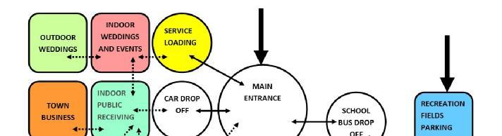
26 Views Existing Views VIEWS FROM NEIGHBORING HOUSES Potential Views VIEW TO FORMAL GARDEN VIEWS TO MEADOWS VIEW TO LARGE BARN ALLÉE OF TREES SCENIC VIEWS TO BROOK VIEW FROM PROSPECT SCENIC VIEW UP HILL


27 Existing Entrances and Circulation Full Site Northern End VEHICULAR ENTRANCE P BUILDING ENTRANCE GARAGE ENTRANCE P P HC ENTRANCE UNPAVED SERVICE ROAD WALKING TRAIL PARKING P P P P
28 Relationship Studies Time/Activity Circulation/Activity Circulation precedents
29 Time/Activity
30 Circulation/Activity


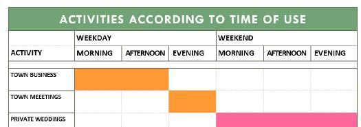
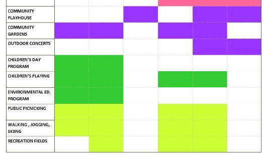
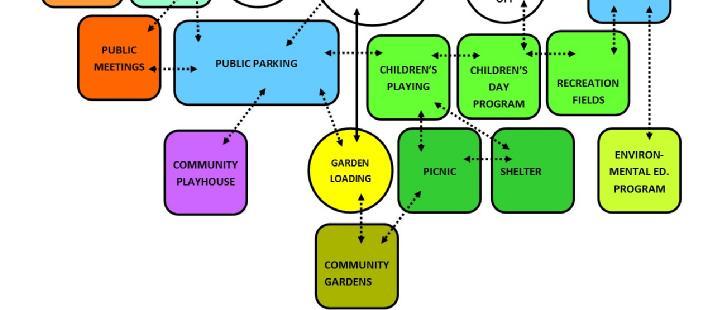
31 Circulation Precedents LAWN PEDESTRIAN PUBLIC ROAD SERVICE ROAD ENTRANCE PARKING TYPICAL ESTATE Precedents set by other estates converted to public use, displayed some common circulation features: A drop-off area in front of the main building General parking moved to a side location and screened Service entry separated from main entry
32 Circulation Concepts Conceptual diagrams suggesting different ways to improve circulation at the northern end of Peuitside: 1. Circulation Spine 2. Vehicle Free Zone 3. Recreation Commons


33 Circulation Study 1 Circulation Spine TENT AREA Drop-off at Lynch House Large event parking at Williams Estate Access drive south of Lynch House Parking for Town Business Separate parking for Barn, Playground and Community Garden New courtyard space between barns Pedestrian path from Pleasant Street to trails following drive

34 Circulation Study 2 Vehicle Free Zone TENT AREA Drop-off at Lynch House Large event parking at Williams Estate Access drive north of Lynch House Carriage Barn removed Parking for Barn events, Playground and Town Business Loading and parking for Community Garden Vehicle free pedestrian path from Lynch House to trails Connection from playground to grass field

35 Circulation Study 3 Recreation Commons TENT AREA Drop-off at Lynch House Large event parking at Williams Estate Access drive north of Lynch House Parking for Barn events, Playground and Town Business New courtyard space between barns Loading and parking for Community Garden Vehicle free pedestrian path from Lynch House to trails Connection from playground to grass field
36 Recommendations 1. Activities and Events 2. Environmental Concerns 3. Historic Structures
37 Activities and Events 1. Improve vehicular and pedestrian circulation 2. Identify activities to be housed in renovated barn(s) 3. Create a planting plan to support and enhance activities 4. Establish partnership with local schools to create environmental education program


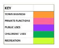
38 Ongoing Activities to Remain 1. Town Offices and Meetings 2. Weddings 3. Children s Day 4. Playground 5. Picnicking 6. Community Gardening 7. Walking, Jogging & Cross Country Skiing 8. Open Play 9. Organized Soccer 1, 2,


39 Suggested New Activities 1. Community Theater 2. Barn Dances 3. Outdoor Concerts 4. Environmental Education 1 & 2 3 4


40 Environmental 1. Develop and implement plan for restoring open meadow 2. Develop a long range plan for managing succession growth trees 3. Create Environmental Education Center with boardwalk to wetlands 2 1 3

41 Historic Structures 1. Improve access to Edward Lynch House and Old Tavern 2. Determine best use for Carriage Barn 3. Renovate Large Barn for community use 4. Stabilize Tilden House and develop plan for use 5. Create a planting plan to reflect the heritage of this historic estate
42 A Unifying Vision A new old vision for the property: One that links the Peuitside Farm community in space and time to the heritage of the colonial farm and the country estate. This vision has the potential to enrich the experience of all users.
43 Agrarian Elements From colonial times, Peuitside Farm has been structured around agriculture. This structure recalls a way of using, caring for, and caring about a place. The Master Plan recommends repurposing the barns, restoring the meadow, and managing the wooded area. THE BARNS THE VEGETABLE GARDEN THE MEADOW THE WOODS THE FIELD THE MARSH THE HEDGEROW THE BROOK
44 19 th Century Refinements Elements from this period layer a human scale on top of the agrarian landscape. The Master Plan wishes to re-introduce the formal Rose Garden and a Pavilion close to the Children s Garden (playground.) In this illustration, the Tilden House is imagined as a Folly, a picturesue building set in the natural landscape. THE CHILDREN S GARDEN THE ROSE GARDEN THE MANOR HOUSE THE FOLLY THE ALLÉE THE GREAT LAWN THE GRAND ENTRY THE PAVILION THE PROSPECT
45 The Future of Peuitside Farm Recognizing and caring for the agrarian elements of this landscape will support the successful public use and management of Peuitside Farm. Conflicts can be minimized through good communication and through developing a strong conceptual framework. Land conservation can be promoted and sustained, and the historic nature of Peuitside Farm can be preserved as well.
46 In Conclusion Peuitside Farm can present itself to the Town of Canton as a jewel of a landscape. Centrally located, it offers open space for all sorts of recreation; its historic buildings are adaptable for public use; and the memory of the farm and natural environment gives the residents of Canton a place of beauty. It provides them the opportunity to appreciate the natural world and connect to the heritage of the town.
47 THE END Thank you for your kind attention.
BISCUIT RUN PARK MASTER PLAN
 BOARD OF SUPERVISORS November 14, 2018 BISCUIT RUN PARK MASTER PLAN COUNTY OF ALBEMARLE ANHOLD ASSOCIATES Contents Project Introduction Property Background County Park Planning Process Existing Site &
ACADEMY AREA CONCEPT PLAN
 ACADEMY AREA Strip ling C hape l Roa d CONCEPT PLAN 7 S2 U Stripling 52 ROADWAYS AND PARKING: ADVENTURE PLAYGROUND AND SPRAYGROUND: Current roadways follow existing drives. It is recommended that the Folds
Fresh Kills Park in Regional Context
 Fresh Kills Park in Regional Context Fresh Kills Location On Staten Island Community District 1 THE SITE TODAY TRAVIS William T. Davis Wildlife Refuge New Jersey NEW SPRINGVILLE MOUND 3/4 Little Fresh
Charles P. Johnson and Associates. Annapolis Landscape Architects
 Charles P. Johnson and Associates Annapolis Landscape Architects AGENDA Introduction Project Limits and Scope Site Analysis Opportunities & Constraints Program Goals Image Boards Design Alternatives Pros
OPEN SPACE TYPES. SIZE 8 acres. SIZE 20 acres. SIZE 1 acre
 TYPICAL CHARACTERISTICS OPEN SPACE TYPES OPEN SPACE TYPES The neighborhood contains an extensive variety of open space types. Most of these spaces incorporate multiple uses and activities, so that each
WARM SPRINGS PARK MASTER PLAN
 TABLE OF CONTENTS page 1.0 Introduction and Overview 1 2.0 Information Gathering 2 3.0 Conceptual Alternative Development 8 4.0 Master Plan Development 14 5.0 Construction Cost Estimates 19 LIST OF FIGURES
WESTERN ILLINOIS UNIVERSITY
 WESTERN ILLINOIS UNIVERSITY Quad Cities Riverfront Campus Master Plan March 1, 2006 Preliminary Master Plan Total Site Build Out Western Illinois University Quad Cities Municipal Park Mississippi River
Dowdy Park. Concept Plans TOWN OF NAGS HEAD NORTH CAROLINA. Developed by: Albemarle & Associates, Ltd VHB/ Vanasse Hangen Brustlin, Inc.
 TOWN OF NAGS HEAD NORTH CAROLINA Concept Plans Developed by: Albemarle & Associates, Ltd VHB/ Vanasse Hangen Brustlin, Inc. Site Looking Southeast Dowdy Park Existing Conditions Nags Head Woods Sound Future
37 Interlaken A Vision To The Future
 37 Interlaken A Vision To The Future The History The Beckwith or Bonnie Briar Estate is one of the original Berkshires Cottages. It was built in 1892 and designed by architect and wealthy owner Leonard
APPENDIX A 6 CONCEPTUAL PRELIMINARY PLAN GUIDE AND CHECKLIST FOR MAJOR SUBDIVISIONS CARRBORO DEVELOPMENT GUIDE APPENDIX A
 6 CONCEPTUAL PRELIMINARY PLAN GUIDE AND CHECKLIST FOR MAJOR SUBDIVISIONS Conceptual Preliminary Guide/Checklist for Major Subdivisions Page 1 FORM: REVIEW DATE: CONCEPTUAL PLAN REVIEW 2000 REVIEWED BY:
Master Plan Presentation August 12, 2015
 Master Plan Presentation August 12, 2015 A vision for tomorrow... May, 13 2015 prepared for: prepared by: SITE LOCATION SITE NTS SITE ANALYSIS +/- 17.8 Ac. RESIDENTIAL HOMES 1 2 RAIL ROAD (SAFETY CONCERNS)
Draft Master Plan for Franklin Park
 Draft Master Plan for Franklin Park Metro Parks Tacoma with SiteWorkshop November 2009 I. overview & background Process & History Master Plan Process The Master Plan is based on a community involvement
Las Colonias Park Master Plan
 2013 Las Colonias Park Master Plan City of Grand Junction June 2013 Introduction Las Colonias Park, a 101 acre parcel on the edge of the Colorado River south of downtown, was deeded to the City of Grand
Design Considerations
 Essential to the development of a successful Master Plan for the Park Complex is input from the community that the park will serve. The community outreach component of the planning process included numerous
Master Site Development Plan (MSDP) Rocky View County Campus at Balzac East
 Rocky View County Campus at Balzac East") Master Site Development Plan (MSDP) Rocky View County Campus at Balzac East Balzac East, Alberta July 2009 CONTENTS 1.0 purpose 1 2.0 guiding principles 2 3.0 site description 3 4.0 site analysis and county
Master Site Development Plan (MSDP) Rocky View County Campus at Balzac East Balzac East, Alberta July 2009 CONTENTS 1.0 purpose 1 2.0 guiding principles 2 3.0 site description 3 4.0 site analysis and county
GARDENS AND ESTATES HORTON COUNTRY HOUSE LONGCROSS ESTATE LA GRANDE MAISON SUDELEY LAWN BARN NEAR BRIXWORTH WINGROVE HOUSE
 Our garden and estate work encompasses both traditional and contemporary design, informed by our skills in historic landscape conservation, and has been consistently well received. We like to work closely
Throughout. square. (Crystal City Vision Plan 2050)
") 1: Terms related to the PSMP document 1 public space (see also public realm, civic space) An open space designated on the regulating plan, accessible to all, including Plazas, Mini Parks, and Neighborhoods
1: Terms related to the PSMP document 1 public space (see also public realm, civic space) An open space designated on the regulating plan, accessible to all, including Plazas, Mini Parks, and Neighborhoods
Gas Works Site Land-Use Study
 City of New Westminster Background Context 2 Neighbourhood Context 3 Program Elements 4 Proposed Site Planning Approach 5 Design Rationale 10 Design Elements 11 Phasing 21 C o n t e n t s b a c k g r o
SOUTHEAST SPORTS COMPLEX MASTER PLAN
 REPORT TO SOUTHGATE NEIGHBORHOOD COUNCIL APRIL 13, 2016 Visioning Process April 30: Stakeholder Meeting with Sports Groups May 5: Stakeholder Meeting with Southgate Land Use Committee May 13: SNC Meeting
BACKGROUND INFORMATION
 13 BACKGROUND INFORMATION PARK OVERVIEW Quail Hollow Park exists today as a natural escape. The historic estate remains true to its 1930s character, as evident in the Manor House, but the surrounding site
CHAPPLES PARK MASTER PLAN. Presentation to Council April 10, 2017
 CHAPPLES PARK MASTER PLAN Presentation to Council April 10, 2017 1 PRESENTATION AGENDA 1. Project Background, Aim and Process 2. The Site Issues and Opportunities 3. Community Engagement 4. Vision and
Authority of the General Plan
 Authority of the General Plan This La Habra Heights General Plan will serve as the blueprint for future planning and development in the City. This General Plan describes the City s vision for the future
Jefferson County Parks & Recreation
 Jefferson County Parks & Recreation Sam Michaels Park Concept Plan Public Meeting October 11, 2018 1 Agenda 1. Welcome and Introductions 2. Project Overview a) Purpose, Need and Goal b) Planning and Design
Hedges Pond Recreation Area & Preserve
 INTRODUCTION Weston & Sampson Master Plan Presentation Hedges Pond Recreation Area & Preserve Plymouth, Massachusetts June 11, 2009 Our Priority: Completion of a Master Plan that establishes realistic
Errol Heights Park and Community Garden Frequently Asked Questions March 22, 2018
 Errol Heights Park and Community Garden Frequently Asked Questions March 22, 2018 Question 1: What improvements are planned for Errol Heights Park? How will the community be engaged in the process to shape
North Oakville East Parks Facilities Distribution Plan. November, 2009
 North Oakville East November, 2009 POLICY CONTEXT 1) Purpose a) The purpose of this document is to be a guide for the location, configuration, design and development of the parks system for the North Oakville
South th E ast Communit ity Centre (SECC)
") South East Community Centre (SECC) 1 New Park Design & Community Centre Update Thursday, February 8, 2018 Public Open House Thank you for attending this Open House! The town and the Consulting Team will
South East Community Centre (SECC) 1 New Park Design & Community Centre Update Thursday, February 8, 2018 Public Open House Thank you for attending this Open House! The town and the Consulting Team will
Preliminary Sketch Plan for Fort Hunter Park
 Preliminary Sketch Plan for Fort Hunter Park Public Presentation November 19, 2009 Dauphin County Parks and Recreation 100 Fort Hunter Road Harrisburg, PA 17110 (717) 599-5188 www.dauphinc.org THOMAS COMITTA
APPENDIX D: PARKS AND RECREATION ACTION PLAN
 APPENDIX D: PARKS AND RECREATION ACTION PLAN Goals The following goals are specific to the development, maintenance, and operation of the existing parks in the Township, as well as the acquisition and
Open Space and Recreational Facilities
 Chapter 5: Open Space and Recreational Facilities A. INTRODUCTION According to the guidelines of the 2001 New York City Environmental Quality Review (CEQR) Technical Manual, an open space analysis is necessary
Terra Nova Rural Park Plan
 Terra Nova Rural Park Plan Part 1 Getting to know the land The Surrounding Area North Side Airport, River, Trail East Side - Residential West Side- Sturgeon Banks, West Dyke Trail South Side:Terra Nova
Marshview Park. Concept Briefing and Feedback Session. Aquarium/Owls Creek Plan Steering Committee March 20, 2012
 Marshview Park Concept Briefing and Feedback Session Aquarium/Owls Creek Plan Steering Committee March 20, 2012 1 Outline of Today s Discussion Introductions Context for Marshview Park Site analysis -
MASTER PLAN IMPLEMENTATION COSTS. Appendix A
 Appendix A MASTER PLAN IMPLEMENTATION COSTS Town of Bradford West Gwillimbury HENDERSON COMMUNITY PARK MASTER PLAN IMPLEMENTATION COSTS Draft Order of Magnitude Costing Revised 5/27/2014 ITEM DESCRIPTION
Standards (R-3) Figure B-11: R-3 Residential Standards Exhibit
 Figure B-11: R-3 Residential Standards Exhibit") Avila Ranch Avila Ranch Specific Plan Development Standards High Medium Density - High Residential Density Residential Lot and Building Lot and Standards Building (R-3) Standards (R-3) EXAMPLES These sketches
Avila Ranch Avila Ranch Specific Plan Development Standards High Medium Density - High Residential Density Residential Lot and Building Lot and Standards Building (R-3) Standards (R-3) EXAMPLES These sketches
Lowe Park Master Plan Update Marion, IA August 25 th, 2011
 Lowe Park Master Plan Update Marion, IA August 25 th, 2011 Lowe Park Master Plan Update Concept Plan - June 1 st, 2011 Agenda 1 - INTRODUCTION Vision Statement Aerial of Existing Condition 2 MASTER PLAN
SARANAC LAKE VISION CONCEPTS
 DRAFT SARANAC LAKE VISION CONCEPTS A GENUINE PLACE TO LIVE, WORK, SHOP AND EXPERIENCE CULTURE IN THE HEART OF THE ADIRONDACKS PHOTO COURTESY OF SARANAC LAKE SARANAC LAKE, NEW YORK DECEMBER 2007 SARANAC
2. Analysis. DRAFT Gerald Richards & Pleasantview Park Master Plan
 DRAFT Gerald Richards & Pleasantview Park Master Plan 19 Historic Features According to the National Register of Historic Places and the National Historic Landmarks Program, there is nothing of national
Campus Master Plan Description Section 6 Storm water management and people places at campus buildings. Section 6 Campus MP Description
 Campus Master Plan Description Section 6 Storm water management and people places at campus buildings Section 6 Campus MP Description THIS PAGE INTENTIONALLY LEFT BLANK. appendix The following provides
Appendix A. Park Land Definitions
 Appendix A Park Land Definitions Mini Park May serve specific function for any and all ages, depending on need of the user area. Size range 1-5 acres with optimum size being 3 acres. Service area is sub-neighborhood
WELCOME TO THE NEW WILTON PARK
 WELCOME TO THE NEW WILTON PARK VISION HISTORY OF WILTON PARK TOWARDS A PLANNING APPLICATION Our objective is to create a truly outstanding environment at Wilton Park. At the heart of our proposals is a
Daniels Park Master Plan
 Daniels Park Master Plan Prepared for: Douglas County & The City and County of Denver October, 2007 EXHIBIT A Contents Daniels Park Overview 2 Project History & Goals 2-3 Regional Context Map 4 Park Zone
Mendota Heights 2040 Comprehensive Plan Draft Vers
 4 Parks and Trails The City of Mendota Heights boasts a variety of recreational and open space opportunities. Few cities can claim access to regional trails, riverside and lakeside parks, scenic bluffs
10 February CAMPUS MASTER PLAN UPDATE Focus Group - Landscape & Hensel Park
 10 February 2016 CAMPUS MASTER PLAN UPDATE Focus Group - Landscape & Hensel Park AGENDA Introductions Planning Scope The 2004 Campus Plan & Survey Observations 2004 Landscape Plan SWOT Exercise Analysis
SMEDLEY TRACT MASTER SITE PLAN Draft Master Plan Presentation
 SMEDLEY TRACT MASTER SITE PLAN Draft Master Plan Presentation Public Meeting #3 03.16.2010 Middletown Township, Pennsylvania MEETING AGENDA Project Schedule Site Analysis Site Concepts Draft Master Site
EXISTING VEHICULAR & PEDESTRIAN CIRCULATION
 46 EXISTING CONDITIONS EXISTING VEHICULAR & PEDESTRIAN CIRCULATION Vehicular and pedestrian circulation patterns are illustrated on this graphic. Campus entry points and major vehicular circulation routes
Physical Structure. This historic image from 1882 emphasizes the dramatic topography that distinguishes Cornell s setting at the top of East Hill.
 Physical Structure The natural, agrarian and urban setting for Cornell s campus is a precious resource to protect and enhance. It has also shaped the physical structure of the campus. Buildings, roads
WELCOME. Land North of STEVENAGE. We would like to thank you for attending our public exhibition today.
 WELCOME We would like to thank you for attending our public exhibition today. The purpose of this event is to share our proposals and hear your thoughts on our ideas. Members of the project team are on
ESTABLISH AN EFFICIENT TOWN CENTER
 ESTABLISH AN EFFICIENT TOWN CENTER 4 Overview Lisbon residents are proud of the history of Newent and at the same time recognize its current importance as a centralized location for a variety of municipal
April 11, 2016 Park Board Chair and Commissioners General Manager Vancouver Board of Parks and Recreation New Brighton Salt Marsh - Preferred Concept
 TO: FROM: SUBJECT: April 11, 2016 Park Board Chair and Commissioners General Manager Vancouver Board of Parks and Recreation New Brighton Salt Marsh - Preferred Concept RECOMMENDATION A. THAT the Vancouver
Update for City Council 7 Years of Progress. May 2013
 Update for City Council 7 Years of Progress May 2013 Setting the Stage Needs Assessment 2006 City of Charlottesville Inventory National Guideline Service Level School Sites Inventory Total Current Inventory
Creating a sense of arrival at campus entrances and at the primary entrances to the Campus Core.
 16.0 LANDSCAPE DESIGN GUIDELINES ELEMENT In campus planning, design professionals whose focus is the outdoors must be sensitive to transitions from building to open space, the need for common areas and
Long Branch-Wayne Local Park Renovation Project
 Montgomery Parks Long Branch-Wayne Local Park Renovation Project Community Meeting #2 September 20, 2016 Oak View Elementary School 7:00-9:00 PM Welcome / Team Introductions M-NCPPC (Montgomery Parks)
DATE: October 25, Park, Recreation and Open Space Advisory Committee (PROSAC) Jordan Harrison, Planner III, RPD Planning Division
 Jordan Harrison, Planner III, RPD Planning Division") DATE: October 25, 2016 TO: FROM: RE: Park, Recreation and Open Space Advisory Committee (PROSAC) Jordan Harrison, Planner III, RPD Planning Division Possible Action on Potential Acquisition at Potrero
DATE: October 25, 2016 TO: FROM: RE: Park, Recreation and Open Space Advisory Committee (PROSAC) Jordan Harrison, Planner III, RPD Planning Division Possible Action on Potential Acquisition at Potrero
South East Sports Complex Phase I
 South East Sports Complex Phase I City of Spokane Design Review Board August 29, 2018 (Revised) Objectives 1. Early discussion and collaboration. 2. Provide framework / catalyst for future improvements
Executive Summary. Parks and Recreation Plan. Executive Summary
 Parks and Recreation Plan Executive Summary The Whitemarsh Township Parks and Recreation Plan sets forth a vision for how Whitemarsh Township can provide a premiere parks and recreation system reflective
Action Item Recommend Initiation of Public Art Project at Bishop Arts Station. Kay Kallos, Public Art Program Manager
 Action Item Recommend Initiation of Public Art Project at Bishop Arts Station COMMITTEE: Cultural Affairs Commission MEETING DATE: March 22, 2018 COUNCIL DISTRICT(S): DEPARTMENT: STAFF: MAPSCO: FUNDING
2011 ASLA Design Awards. Centennial Park Merit Award Design Concepts CLA, Inc. Design over $500,000 Construction Budget
 2011 ASLA Design Awards Centennial Park Merit Award Design Concepts CLA, Inc. Design over $500,000 Construction Budget 2011 ASLA Colorado Professional Design Awards Project Name: Category: Location: Const.
ATTACHMENT A AERIAL PHOTO OF McINTIRE PARK EAST
 ATTACHMENT A AERIAL PHOTO OF McINTIRE PARK EAST McIntire Botanical Garden Request for Proposals Attachments Page 1 of 33 ATTACHMENT B - MEMORANDUM OF AGREEMENT WITH THE CITY OF CHARLOTTESVILLE McIntire
BROOKHILL NEIGHBORHOOD MODEL ZONING MAP AMENDMENT PREFACE TO APPLICATION
 BROOKHILL NEIGHBORHOOD MODEL ZONING MAP AMENDMENT PREFACE TO APPLICATION June 15, 2015 Revised: August 1, 2016 I. VISION Brookhill is a proposed community based upon the principles of Albemarle County
Chapter 5: Natural Resources and Environment
 NATURAL RESOURCES AND ENVIRONMENT 5-1 5 Chapter 5: Natural Resources and Environment BACKGROUND AND INTENT Urban expansion represents the greatest risk for the future degradation of existing natural areas,
Open Space and Recreational Resources
 Chapter 3: Open Space and Recreational Resources A. INTRODUCTION Under the 2012 City Environmental Quality Review (CEQR) Technical Manual guidelines, open space is defined as publicly accessible, publicly
CAMPUS MASTER PLAN UPDATE
 13 April 2016 CAMPUS MASTER PLAN UPDATE Focus Group Landscape AGENDA What We Heard Review of Campus Observations & Analysis Campus Framework & Open Space Network Table-Top Exercise Landscape Guideline
The Mystic River Greenway
 The Mystic River Greenway City of Medford November 30, 2006 MIT Department of Urban Studies and Planning The Mystic River Greenway A greenway is a regional network that connects: Open Space Visibility,
MARINA MARKET & WATERFRONT DEVELOPMENT STUDY PORT ARANSAS, TEXAS
 MARINA MARKET & WATERFRONT DEVELOPMENT STUDY PORT ARANSAS, TEXAS FEBRUARY 2015 PRESENTATION OUTLINE 1 2 3 4 5 6 7 REGIONAL POSITIONING SITE IMPRESSIONS PLANNING & DESIGN PRINCIPLES EXISTING IMPROVEMENTS
Colchester Northern Gateway Master Plan Vision Review Draft. July 2016
 Colchester Northern Gateway Master Plan Vision Review Draft July 2016 Contents Introduction 4 Context 8 Purpose of the Report 8 Strategic Position 9 Overview of the Process 11 2012 Master Plan Vision 12
Tonight s Agenda. Disbrow Park & Facilities Master Plan
 Disbrow Park & Facilities Master Plan Public Outreach Forum City of Rye, NY May 11, 2017 Tonight s Agenda. Break (10 min) Introduction: What s in the works? Stantec Presentation - Goals and objectives
Silverwood Masterplan Kickoff Meeting. Jim Neidhart Dane County Parks Planning
 Silverwood Masterplan Kickoff Meeting Jim Neidhart Dane County Parks Planning 608-224-3614 January 30, 2014 Silverwood County Park Public Information Meeting Notice Sent notice to all landowners adjacent
DATE: June 20, 2018 Civic Design Review Committee of the Arts Commission FROM: Nicholas Perry, Senior Planner (415)
") DATE: June 20, 2018 TO: Civic Design Review Committee of the Arts Commission FROM: Nicholas Perry, Senior Planner (415) 575-9066 RE: Civic Center Public Realm Plan SUMMARY The Civic Center Public Realm
DATE: June 20, 2018 TO: Civic Design Review Committee of the Arts Commission FROM: Nicholas Perry, Senior Planner (415) 575-9066 RE: Civic Center Public Realm Plan SUMMARY The Civic Center Public Realm
The Vision. Photo provided by The Minervini Group. 46 Vision, Objectives & Strategies
 Vision, Objectives & Strategies The is the public framework and guide for future development of the Grand Traverse Commons. The establishes public polices for infrastructure, the preservation of natural
IMAGINE CLEARWATER. Community Workshop 3. November 2016
 IMAGINE CLEARWATER Community Workshop 3 November 2016 Imagine Clearwater has been a 6-month community-focused process to re-envision the downtown waterfront. VISIONING FRAMEWORK MASTER PLAN HOW CAN WE
MASTER PLAN for the EARL NEWHOUSE WATERFRONT
 MASTER PLAN for the EARL NEWHOUSE WATERFRONT on RESERVOIR POND - CANTON, MA Community Meeting #2 - Thursday, January 11 th PROJECT INTRODUCTION Project Goals: To prepare a MASTER PLAN which develops the
Stowford Mill, Ivybridge Introduction
 Stowford Mill, Ivybridge Introduction 1. What is the purpose of this exhibition? Burrington Estates would like residents and interested parties to have the opportunity to review updated proposals for the
Fair Oaks Ranch Homeowners Association Parks and Trails Master Plan & 2019 Budget Planning
 Fair Oaks Ranch Homeowners Association Parks and Trails Master Plan & 2019 Budget Planning Sticky Dot Voting Priorities Community Survey Results Board Title Votes Parks, Open Spaces, and Trails 328 Emergency
EXISTING CONDITIONS 41. Existing Conditions
 EXISTING CONDITIONS 41 Existing Conditions The Existing Analysis phase of the planning process involved a study of the existing conditions on the campus in order to identify key planning issues to be addressed
PHASE 3-4 PARKS SOUTH PARK AND CHANNEL PARK
 PHASE 3-4 PARKS SOUTH PARK AND CHANNEL PARK Sheet List L1.0 L2.0 L3.0 L4.0 L5.0 L6.0 L7.0 L8.0 L9.0 L10.0 L11.0 L12.0 L13.0 L14.0 L15.0 L16.0 L17.0 L18.0 L19.0 L20.0 L21.0 L22.0 Cover Open Space Context
8.2 Sector 2 Kelburn Park
 8.2 Sector 2 Kelburn Park Kelburn Park, near Victoria University 8.2.1 Character and use Kelburn Park is a sector of the Town Belt, of a scale and character more like a suburban park. However, the woodland
Appendix 1. Private Projects with Respective On Site PUS and Public Parks in the Silver Spring CBD
 Appendix 1 Private Projects with Respective On Site PUS and Public Parks in the Silver Spring CBD Green Space Guidelines for the Silver Spring Central Business District montgomery county planning board,
Girdwood Cemetery Girdwood, Alaska
 Miners Pond Shelter Council Circle Woodl Trails Overlooks Committal Shelter Courts Woodl Burial Bridge to Beaver Pond Trail Protected Stream Valleys Columbarium Court Shelter Woodl Trails Woodl Cremation
LSU Hilltop Arboretum Master Plan. August 2017
 LSU Hilltop Arboretum Master Plan August 2017 HISTORY AND OVERVIEW Hilltop Arboretum was entrusted to Louisiana State University in 1981 as a gift from its former resident and creator, Emory Smith. Emory
W&OD PARK MASTER PLAN. The City s Greenest Street. DRAFT W&OD Trail Master Plan v4.docx Page 1
 W&OD PARK MASTER PLAN Adopted XXX-XX-XXXX The City s Greenest Street DRAFT W&OD Trail Master Plan v4.docx Page 1 Introduction and Purpose The Washington & Old Dominion Railroad Regional Park (W&OD) (which
Why Are We Here? Mrs. Farrow protected this land. CCPRC Acquires Property. Funding Appropriated. Structure Stabilization
 Why Are We Here? Mrs. Farrow protected this land CCPRC Acquires Property Funding Appropriated Structure Stabilization Programs at Park Master plan implement improvements Project Team Introductions & Roles
INVENTORY NARRATIVE BUILDING AND COMMON AREA LANDSCAPING
 INVENTORY NARRATIVE BUILDING AND The information within these Inventories was gathered between of March and August, 2015. Many aspects of the Inventories will be on-going as major features and minor elements
Glenborough at Easton Land Use Master Plan
 Public Facilities 102 7.0 PUBLIC FACILITIES 7.1 OVERVIEW This chapter describes the public facilities that will provide high-quality services in the Glenborough at Easton community, to include three schools,
Design Guidelines. High Point Estates Design Guidelines April Gomberoff Bell Lyon Architects Group Inc.
 High Point Estates April 2006 Gomberoff Bell Lyon Architects Group Inc. 1 29 Contents Part One The Building Scheme Part Two Architectural Character and Siting Building Part One: The Building Scheme i 31
Recreation Facility Evaluation - Conclusions
 2015 Parks Report Upon initial assessment of the Village parks it was evident that the inventory of the Village s park land, athletic fields, recreational facilities, playgrounds, trails, etc., was substantial,
February 27, 2018 City Council Presentation The Crown Jewel Park in the City of Fairfax
 February 27, 2018 City Council Presentation The Crown Jewel Park in the City of Fairfax Master Planning Charge Van Dyck Park s first Master Plan will provide the City with a road map as to how best incorporate
Overview Report. Proposed Development
 Overview Report Proposed Development the construction of a 1km cycle/pedestrian trail including a new footbridge, new car park and entrance road at Drumshanbo Lock and a new pedestrian/cycle road crossing,
Moreno Valley College: Conceptual Master Planning - Site Analysis Lasselle Street, Moreno Valley, CA 92551
 Master Plan Architect School Name Moreno Valley College District Riverside Community College District Architecture and Urban Design 5898 Blackwelder Street Ground Floor Culver City, CA 90232 T: 310.559.5720
Working Group Meeting
 April 4,, 2017 Parks Operations Bldg Working Group Meeting Arts Districts Overview Stormwater/RPA/Stream Considerations First Principles Agenda 7:00pm 7:05pm 7:10pm 7:40pm 8:30pm 9:40pm 9:45pm Welcome
Great Easton Sustainable Housing Development Sites - Site Seven, Broadgate extension site SHLAA Ref HSG/03)
") Great Easton Sustainable Housing Development Sites - Site Seven, Broadgate extension site SHLAA Ref HSG/03) 1. Introduction The Great Easton Neighbourhood Plan Group are preparing a Neighbourhood Plan
Great Easton Sustainable Housing Development Sites - Site Seven, Broadgate extension site SHLAA Ref HSG/03) 1. Introduction The Great Easton Neighbourhood Plan Group are preparing a Neighbourhood Plan
Regional Context Statement
 Regional Context Statement REGIONAL CONTEXT STATEMENT 3. REGIONAL CONTEXT STATEMENT In 1995, the Provincial Government passed into law the Growth Strategies Act. The purpose of this provincial initiative
Public Consultation. Land at Monks Farm, North Grove. Welcome
 Welcome Welcome to our public exhibition for development on Land at Monks Farm, orth Grove. Gallagher Estates and Gleeson Strategic Land are preparing an outline planning application for new homes, open
Parks, and Recreation & Cultural Arts Master Plan Update
 Parks, and Recreation & Cultural Arts Master Plan Update Community Profile Public Input Summary: Staff Interviews conducted April 14 and 15, 2014 Citizens Workshop - conducted April 15 th and 24 th, May
Call for Artists for: Design and Construction of Environmental Art Activation Story Mill Community Park, Bozeman, MT
 Call for Artists for: Design and Construction of Environmental Art Activation Story Mill Community Park, Bozeman, MT Seeking artists to design, fabricate and install art elements in the nature sanctuary
Introduction. Welcome to this consultation regarding the draft redevelopment proposals for the former CeramTec factory on Sidmouth Road, Colyton.
 Introduction Welcome to this consultation regarding the draft redevelopment proposals for the former CeramTec factory on Sidmouth Road, Colyton. We are currently considering options for the mixed-use redevelopment
David Ache, representing Councilmember Hucker s office was present during the first portion of the meeting.
 Long Branch Wayne LP Renovation Project Community Meeting #1 March 8, 2016 Park Staff Present at Community Meeting #1 Lucas Bonney, Project Manager, Park Development Michael Ma, Park Development Tricia
JCB & MIAMI SEWER SEPARATION PROJECT & ADAMS PARK WETLAND
 JCB & MIAMI SEWER SEPARATION PROJECT & ADAMS PARK WETLAND 30% Public Meeting November 29 th, 2012 ADAMS PARK MASTER PLAN H3 Studio Tonight s Agenda Review Adams Park Master Plan (H3 Studio) Context & Analysis
UTSC SECONDARY PLAN COMMUNITY OPEN HOUSE
 WELCOME TO THE UTSC SECONDARY PLAN COMMUNITY OPEN HOUSE 1 Welcome to the first Community Open House for the UTSC Secondary Plan. Hosted by the University of Toronto Scarborough (UTSC), the following panels
Master Plan Objectives and Policies
 Master Plan Objectives and Policies Introduction This chapter identifies the Park issues and recommended policies established by this Master Plan. The issues were identified through meetings with staff,
CHAPTER 22 Rural Open Space Community Developments
 CHAPTER 22 Rural Open Space Community Developments Section 22.1 Description and Purpose The intent of this Chapter is to offer property owners an alternative to traditional zoning requirements for rural