Project Overview & Summary of Existing Conditions
|
|
|
- Opal Woods
- 5 years ago
- Views:
Transcription

1 Project Overview & Summary of Existing Conditions
2 1 Project Overview Project Goals, History, Scope 2 Timeline / Process Overall Process & Where We Are Task Force Process & Role of Task Force Existing Conditions Critical Areas Along the Street 4 Task Force Additional Task Force Members? Finalized February Meeting Dates Attendance/Role at Public Meetings Reporting Back
3 1 Project Overview Project Goals, History, Scope 2 Timeline / Process Overall Process & Where We Are Task Force Process & Role of Task Force Existing Conditions Critical Areas Along the Street 4 Task Force Additional Task Force Members? Finalized February Meeting Dates Attendance/Role at Public Meetings Reporting Back
4 Tennyson Streetscape Project Background Tennyson Street (between 8th and 44th Avenues) has a long history as a neighborhood retail district. In its basic form, it is a walkable, compact district, with an eclectic mix of retailers, shops, offices and residences. Architecturally,thereisgreatvarietyinbothdensityandcharacter with single family detached Victorian homes on the same block with newly constructed post modern multi story infill developments built to property line. When walking or driving within the district, there is a sense that the commercial corridor has been energized by pockets of redevelopment, as well as individual property owners updating existing building facades. It is evident that tremendous potential exists for this commercial district. The retail along the street has great variety, with a few long standing restaurants, retailers and businesses that have an established presence along the street. Most of these long term members of the district own their buildings or shops, and have made substantial improvements to existing buildings, or have constructed/purchased new storefronts. However, the bulk of the retail within the project area is entrepreneurial smaller, newer shops/businesses that are within the first five years of operation, and who rent their spaces. As an incubator business area, the district benefits from the energy and vibrancy of an artistic and eclectic mix of shops and art galleries, most of whom are run by the owners. The experience of walking into a shop and being met by the store owner who is often the sole proprietor is alive and well along Tennyson Street. Improvements to the streetscape should capitalize on the passion and commitment of both the established and incubator businesses, helping to create a welcoming and dynamic 'front door' that reflects the spirit and character of the district and becomes a destination within the Metro Denver community. PROJECT OVERVIEW 1

5 Tennyson Streetscape Bond Project In 2007, Denver voters approved ballot initiatives that established the Better Denver Bond Program. Approximately $2M was allocated for the Tennyson corridor to implement streetscaping improvements on sections of the street between 8 th and 44 th Avenues. PROJECT OVERVIEW 1
6 Tennyson Streetscape Maintenance The City and County of Denver has a policy that any capital improvements adjacent to private property must be maintained by the property owner(s). District creation is a mechanism that would provide and fund such maintenance. LMD Local Maintenance District LID Local Improvement District PROJECT OVERVIEW 1
 a new program designed to strengthen business districts and their surrounding neighborhoods citywide PROJECT")
7 In May 2008 the Tennyson Street Corridor (between 8th and 46th Avenues) was selected by the City of Denver s Office of Economic Development (OED) to be a pilot district for: Denver s Neighborhood Marketplace Initiative (DNMI) a new program designed to strengthen business districts and their surrounding neighborhoods citywide PROJECT OVERVIEW 1


8 Tennyson Corridor Development Plan Goals Established a NICHE STRATEGY for the district Completed an extensive PUBLIC OUTREACH effort (including a comprehensive ONLINE SURVEY) Completed a district-wide MARKET ANALYSIS Outlined a REDEVELOPMENT STRATEGY for the district, including FINANCING MECHANISMS PROJECT OVERVIEW 1
9 Project Area Chavez Park Tennyson Terrace Project Improvement Area Chavez Park & Tennyson Terrace (excluded from streetscape bond project) Improvement Area is from Back of Curb to Property Line Public Realm Improvements Tied to Bond Funding Requirements Roadway Improvements PROJECT OVERVIEW 1
10 Project Area Chavez Park Tennyson Terrace PROJECT STATEMENT Funded through Denver s Build a Better Denver bond initiative, the Tennyson Streetscape Conceptual Design Project will create an improvement plan for updates to portions of Tennyson Street between 8th and 44th Avenues. PROJECT OVERVIEW 1
11 1 Project Overview Project Goals, History, Scope 2 Timeline / Process Overall Process & Where We Are Task Force Process & Role of Task Force Existing Conditions Critical Areas Along the Street 4 Task Force Additional Task Force Members? Finalized February Meeting Dates Attendance/Role at Public Meetings Reporting Back
12 1 Project Overview Project Goals, History, Scope 2 Timeline / Process Overall Process & Where We Are Task Force Process & Role of Task Force Existing Conditions Critical Areas Along the Street 4 Task Force Additional Task Force Members? Finalized February Meeting Dates Attendance/Role at Public Meetings Reporting Back
13 Tennyson Street Process Overview TIMELINE / PROCESS 2
:")


14 Tennyson Street Process Overview NEXT STEPS Preliminary Plans (0%): May 2010 Advertisement: December 2010 Bid Opening: January 2010 Start Construction: April 2011 End Construction: November 2011 TIMELINE / PROCESS 2


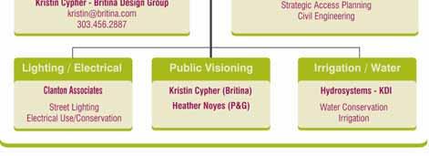
15 Tennyson Street Project Team TIMELINE / PROCESS 2

16 Take-Away Information Sheet TIMELINE / PROCESS 2

17 TASK FORCE PROCESS 8 INDIVIDUAL GROUP MEETINGS TIMELINE / PROCESS 2
18 TASK FORCE PROCESS Task Force Representatives Spokespeople and advocates for the groups they represent Share project information with other members of their groups Identify issues, concerns and preferred improvements to the project area TIMELINE / PROCESS 2
19 Tennyson Street Process Overview Task Force Input Throughout Project TIMELINE / PROCESS 2

20 Information-Gathering Survey TIMELINE / PROCESS 2
21 1 Project Overview Project Goals, History, Scope 2 Timeline / Process Overall Process & Where We Are Task Force Process & Role of Task Force Existing Conditions Critical Areas Along the Street 4 Task Force Additional Task Force Members? Finalized February Meeting Dates Attendance/Role at Public Meetings Reporting Back
22 1 Project Overview Project Goals, History, Scope 2 Timeline / Process Overall Process & Where We Are Task Force Process & Role of Task Force Existing Conditions Critical Areas Along the Street 4 Task Force Additional Task Force Members? Finalized February Meeting Dates Attendance/Role at Public Meetings Reporting Back
23 Project Area Chavez Park Tennyson Terrace Existing Conditions Zoning Main Street Zoning Survey ROW Width Out of Project Area Drainage Road Crown Sidewalk Grades / Slopes / Width Retaining Walls Pedestrian Crossings / Gateways Lighting & Electrical Street Trees Streetscape Amenities
24 Existing Conditions The current architectural character of the district is an almost 50/50 split between zero-lot-line historic storefronts and single family residences that either retain their residential use, or which have been converted into shops and office spaces. Zoning Main Street Zoning Survey ROW Width Out of Project Area Drainage Road Crown Sidewalk Grades / Slopes / Width Retaining Walls Pedestrian Crossings / Gateways Lighting & Electrical Street Trees Streetscape Amenities

25 Restaurant uses former front yard for outdoor café seating

26 Single-family home with business located in alley property

27 Single-family detached home used for businesses

28 New bakery in single family home (note small front yard)

29 Single family Victorians adaptively reused

30 Fence separates outdoor café from street

31 Storefronts and single family structures set back from the street

32 Blank façade faces the street

33 Building entrance faces the parking lot not the street

34 Wide curb cuts are not pedestrianfriendly

35 Chavez Park edge (out of project construction funding)

36 Single family residential abuts retail storefront

37 Row of retail in storefronts and single story residential structure
38 Project Area Chavez Park Tennyson Terrace Existing Conditions Zoning Main Street Zoning Survey ROW Width Out of Project Area Drainage Road Crown Sidewalk Grades / Slopes / Width Retaining Walls Pedestrian Crossings / Gateways Lighting & Electrical Street Trees Streetscape Amenities
39 Existing Conditions The width of the street right-of-way varies along Tennyson Street between 8th Ave to 44th Ave. This project will verify and update survey data to clearly define the correct ROW width. Zoning Main Street Zoning Survey ROW Width Out of Project Area Drainage Road Crown Sidewalk Grades / Slopes / Width Retaining Walls Pedestrian Crossings / Gateways Lighting & Electrical Street Trees Streetscape Amenities

40 Range Points

41 Range Points

42 Range Points
43 Project Area Chavez Park Tennyson Terrace Existing Conditions Zoning Main Street Zoning Survey ROW Width Out of Project Area Drainage Road Crown Sidewalk Grades / Slopes / Width Retaining Walls Pedestrian Crossings / Gateways Lighting & Electrical Street Trees Streetscape Amenities
44 Project Area Chavez Park Tennyson Terrace Existing Conditions Zoning Main Street Zoning Survey ROW Width Out of Project Area Drainage Road Crown Sidewalk Grades / Slopes / Width Retaining Walls Pedestrian Crossings / Gateways Lighting & Electrical Street Trees Streetscape Amenities
45 Existing Conditions Current drainage along Tennyson does not create positive flows into the drainage system, causing winter ice damming and overflows onto sidewalks in spring and summer rains. Older and damaged sections of sidewalk have resulted in some surface drainage flowing onto private property. There are two storm sewers within the project area, located at the intersection of Tennyson and 8th Ave and Tennyson and 44th Ave. Zoning Main Street Zoning Survey ROW Width Out of Project Area Drainage Road Crown Sidewalk Grades / Slopes / Width Retaining Walls Pedestrian Crossings / Gateways Lighting & Electrical Street Trees Streetscape Amenities

46 Ice damming south of 44 th & Tennyson

47 Ice damming south of 44 th & Tennyson
48 Project Area Chavez Park Tennyson Terrace Existing Conditions Zoning Main Street Zoning Survey ROW Width Out of Project Area Drainage Road Crown Sidewalk Grades / Slopes / Width Retaining Walls Pedestrian Crossings / Gateways Lighting & Electrical Street Trees Streetscape Amenities
49 Existing Conditions After years of asphalt overlays, the Tennyson Street road crown is steeply sloped - eliminating the original 6 curb and 24 gutter. Steeper slopes are difficult for cars to navigate and result in awkward slopes for parallel parked vehicles. The layers of asphalt that create the steep roadway crown also have contributed to the drainage problems along the street - gradually lowering the curb face to 4" or less, and making an uneven flow line for stormwater conveyance to the inlets at 44 th and Tennyson. Zoning Main Street Zoning Survey ROW Width Out of Project Area Drainage Road Crown Sidewalk Grades / Slopes / Width Retaining Walls Pedestrian Crossings / Gateways Lighting & Electrical Street Trees Streetscape Amenities

50 Steep road crown exists on unimproved portions of Tennyson
51 Project Area Chavez Park Tennyson Terrace Existing Conditions Zoning Main Street Zoning Survey ROW Width Out of Project Area Drainage Road Crown Sidewalk Grades / Slopes / Width Retaining Walls Pedestrian Crossings / Gateways Lighting & Electrical Street Trees Streetscape Amenities
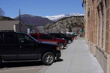
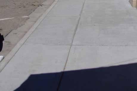
52 Existing Conditions SIDEWALK WIDTHS There is great variety in the existing sidewalks widths, ranging from areas with a 5' detached concrete sidewalk (the smallest sidewalk areas) to larger sections (greater than 12') that have a continuous sidewalk from the curb to the building face. The areas with the largest percentage of continuously wide sidewalks are the side streets that link into Tennyson from the east and west. From 9th through 4rd Streets, there are sections of very wide sidewalks that provide significant opportunity for enhancement. Zoning Main Street Zoning Survey ROW Width Out of Project Area Drainage Road Crown Sidewalk Grades / Slopes / Width Retaining Walls Pedestrian Crossings / Gateways Lighting & Electrical Street Trees Streetscape Amenities

53 Detached sidewalk

54 Zero lot line allows sidewalk to extend to edge of storefront

55 Zero lot line allows sidewalk to extend to edge of storefront

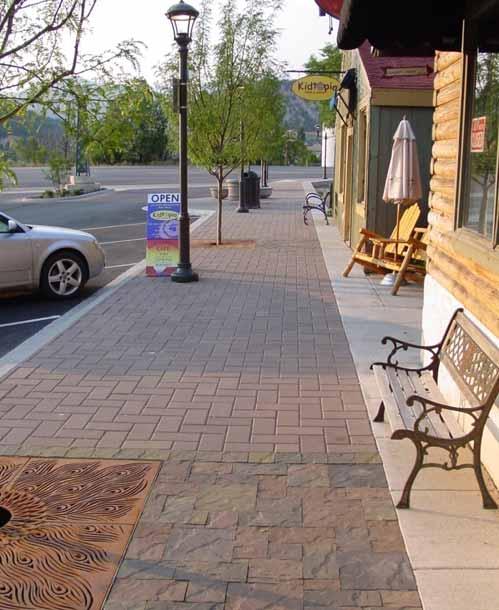
56 Wider sidewalks allow for comfortable outdoor eating/dining

57 Detached sidewalks are City & County of Denver standard

58 Detached sidewalk with property fences and deep building setbacks

59 Side streets have consistently wide sidewalk areas

60 Side streets have consistently wide sidewalk areas

61 Row of attached storefronts (approx. 15 sidewalk area)
62 Existing Conditions SIDEWALK GRADES/SLOPES There are locations along Tennyson Street where the sidewalk cross-slope does not meet ADA standards. There is also a significant grade separation between the sidewalk and the back of curb, which poses a tripping hazard and can be an obstacle to vehicles parallel parked when trying to open a door. The pedestrian crossing areas also do not meet current ADA standards for truncated domes on accessible ramps. Zoning Main Street Zoning Survey ROW Width Out of Project Area Drainage Road Crown Sidewalk Grades / Slopes / Width Retaining Walls Pedestrian Crossings / Gateways Lighting & Electrical Street Trees Streetscape Amenities

63 Grades and slopes do not meet ADA requirements

64 Non-ADA compliant
65 Project Area Chavez Park Tennyson Terrace Existing Conditions Zoning Main Street Zoning Survey ROW Width Out of Project Area Drainage Road Crown Sidewalk Grades / Slopes / Width Retaining Walls Pedestrian Crossings / Gateways Lighting & Electrical Street Trees Streetscape Amenities
66 Existing Conditions There are a number of older retaining walls adjacent to the Tennyson Street sidewalks that may be located within the public right-of-way. Their close proximity to the right-ofway and existing back of walk will create a very tight construction width. NOTE: The retaining walls on the east side of Tennyson located between 41 st and 4 rd street appear to be failing. Zoning Main Street Zoning Survey ROW Width Out of Project Area Drainage Road Crown Sidewalk Grades / Slopes / Width Retaining Walls Pedestrian Crossings / Gateways Lighting & Electrical Street Trees Streetscape Amenities

67 Retailing wall along east side of Tennyson
68 Project Area Chavez Park Tennyson Terrace Existing Conditions Zoning Main Street Zoning Survey ROW Width Out of Project Area Drainage Road Crown Sidewalk Grades / Slopes / Width Retaining Walls Pedestrian Crossings / Gateways Lighting & Electrical Street Trees Streetscape Amenities
69 Existing Conditions PEDESTRIAN CROSSINGS There are two 4-way intersections within the project area - at 44th and 8th Avenues. These intersections also serve as the primary gateways into the district. The 8 th Avenue intersection has a wide cross-section, heavy traffic flows and pedestrian ramps that do not meet ADA standards. Zoning Main Street Zoning Survey ROW Width Out of Project Area Drainage Road Crown Sidewalk Grades / Slopes / Width Retaining Walls Pedestrian Crossings / Gateways Lighting & Electrical Street Trees Streetscape Amenities

70 The staggered intersections to not provide E-W crossing

71 The staggered intersections to not provide E-W crossing

72 The staggered intersections to not provide E-W crossing

73 The staggered intersections to not provide E-W crossing

74 Curb cuts are places where cars and pedestrians interact

75 Curb cuts are places where cars and pedestrians interact

76 Curb cuts are places where cars and pedestrians interact

77 Curb cuts are places where cars and pedestrians interact
78 Existing Conditions GATEWAYS The most important gateway leading into the Tennyson project area is at the intersection of Tennyson and 8th Avenue. Currently, both the land uses and physical spaces at this gateway do not promote the district or create awareness/desire to enter. 8th Avenue also has a wide cross-section/heavy traffic flows in this area, which limits adjacent residential foot traffic into the district, and prevents it from capitalizing on potential shoppers that would have more interest in visiting the district if they could easily cross 8th Avenue. Zoning Main Street Zoning Survey ROW Width Out of Project Area Drainage Road Crown Sidewalk Grades / Slopes / Width Retaining Walls Pedestrian Crossings / Gateways Lighting & Electrical Street Trees Streetscape Amenities
79 Intersection of 8 th & Tennyson project gateway area

80 Intersection of 8 th & Tennyson project gateway area
81 Project Area Chavez Park Tennyson Terrace Existing Conditions Zoning Main Street Zoning Survey ROW Width Out of Project Area Drainage Road Crown Sidewalk Grades / Slopes / Width Retaining Walls Pedestrian Crossings / Gateways Lighting & Electrical Street Trees Streetscape Amenities
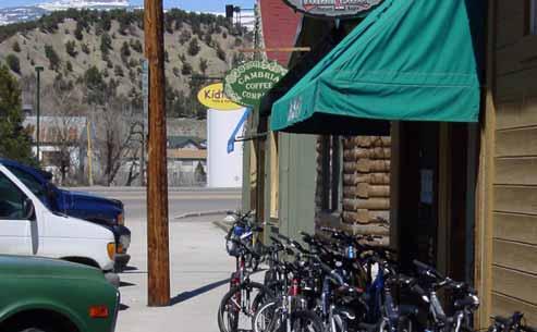
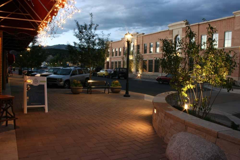
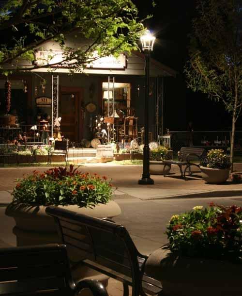
82 Existing Conditions Existing lighting and electrical are served by overhead telephone poles and cobra-head fixtures. The poles are widely spaced along the street, generally located in tree lawns or along the edges of sidewalks. Aside from acorn lights located along Tennyson Terrace, no pedestrian-scale lighting exists along the corridor. Zoning Main Street Zoning Survey ROW Width Out of Project Area Drainage Road Crown Sidewalk Grades / Slopes / Width Retaining Walls Pedestrian Crossings / Gateways Lighting & Electrical Street Trees Streetscape Amenities

83 Overhead cobra lights are the only existing fixtures in the study area
84 Project Area Chavez Park Tennyson Terrace Existing Conditions Zoning Main Street Zoning Survey ROW Width Out of Project Area Drainage Road Crown Sidewalk Grades / Slopes / Width Retaining Walls Pedestrian Crossings / Gateways Lighting & Electrical Street Trees Streetscape Amenities
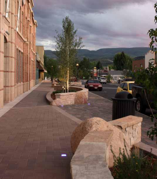
85 Existing Conditions Existing trees in Tennyson Terrace have dense canopies and are difficult to limb up so views into shop windows can be maintained. The honeylocust trees north of 44 th Avenue (on the east side) are examples of excellent street trees. Any new trees proposed along Tennyson will adhere to the City and County of Denver Street Tree Standards. Zoning Main Street Zoning Survey ROW Width Out of Project Area Drainage Road Crown Sidewalk Grades / Slopes / Width Retaining Walls Pedestrian Crossings / Gateways Lighting & Electrical Street Trees Streetscape Amenities

86 Trees in existing maintenance district block views into storefronts

87 Trees in existing maintenance district block views into storefronts

88 Honeylocust trees are open, airy and easily limbed up
89 Project Area Chavez Park Tennyson Terrace Existing Conditions Zoning Main Street Zoning Survey ROW Width Out of Project Area Drainage Road Crown Sidewalk Grades / Slopes / Width Retaining Walls Pedestrian Crossings / Gateways Lighting & Electrical Street Trees Streetscape Amenities
90 Existing Conditions Along sections of the block between 8 th and 9 th Avenues, there is an increased amount of visible trash and graffiti along the street. This block also projects a very 'rough' character with high fences, unadorned, expansive wall facades, parking lots with locked and barred access, vending machines along the street and little continuous storefronts. Overall, the Tennyson corridor suffers from physical fragmentation and lack of coherance. While Tennyson Terrace serves as a viable link between the north and south sections of the study area, the overall corridor has several sections where long fences (as is the case along Chavez Park) and deep building setbacks create a lack of continuity in the pedestrian experience. Zoning Main Street Zoning Survey ROW Width Out of Project Area Drainage Road Crown Sidewalk Grades / Slopes / Width Retaining Walls Pedestrian Crossings / Gateways Lighting & Electrical Street Trees Streetscape Amenities

91 Existing Tennyson Terrace improvements

92 Handmade bench installed by property / business owner

93 Improvements installed by property owner


94 Before & After Eagle, Colorado
95

96
97
98
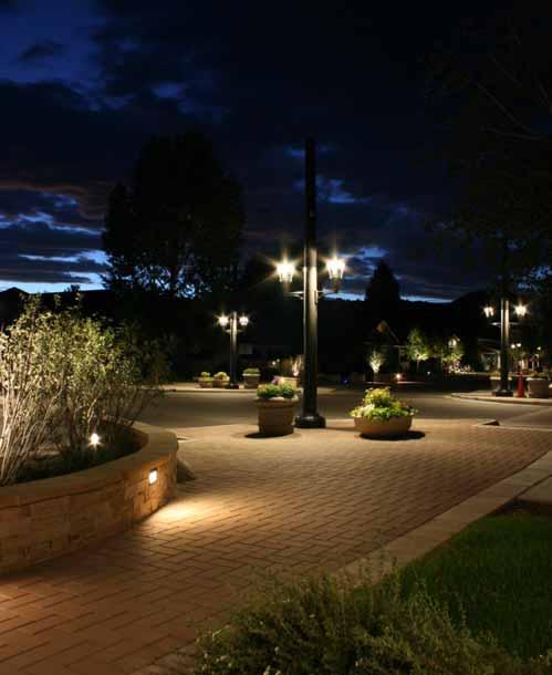
99 OPPORTUNITIES. Trash Receptacles Benches Banners Monuments Street Trees Pedestrian Lights Public Art


100 OPPORTUNITIES. Keep District Tidy Enhance Commercial District Trash Receptacles Benches Banners Monuments Street Trees Pedestrian Lights Public Art COST: $1,000 - $,000 / each


101 OPPORTUNITIES. Enhance the pedestrian environment Enliven commercial districts by fostering community life Trash Receptacles Benches Banners Monuments Street Trees Pedestrian Lights Public Art COST: $2,000 - $,000 / each


102 OPPORTUNITIES. Create community identity Enhance commercial district Trash Receptacles Benches Banners Monuments Street Trees Pedestrian Lights Public Art COST: $00 - $600 / each

103 OPPORTUNITIES. Create community identity Enhance commercial district Trash Receptacles Benches Banners Monuments Street Trees Pedestrian Lights Public Art COST: $10,000 & UP

104 OPPORTUNITIES. Create more comfortable Walking environment Improve air quality green Trash Receptacles Benches Banners Monuments Street Trees Pedestrian Lights Public Art COST: $10,000 - $17,000 / each

105 OPPORTUNITIES. Create safer walking environment Enhance commercial district Improve nighttime security Trash Receptacles Benches Banners Monuments Street Trees Pedestrian Lights Public Art COST: $10,000 - $17,000 / each

106 OPPORTUNITIES. Enhance community identity Create focal point / gathering areas along the street Trash Receptacles Benches Banners Monuments Street Trees Pedestrian Lights Public Art COST: 1% (~$20,000)
107 1 Project Overview Project Goals, History, Scope 2 Timeline / Process Overall Process & Where We Are Task Force Process & Role of Task Force Existing Conditions Critical Areas Along the Street Before & After Examples 4 Task Force Additional Task Force Members? Finalized February Meeting Dates Attendance/Role at Public Meetings Reporting Back
108 1 Project Overview Project Goals, History, Scope 2 Timeline / Process Overall Process & Where We Are Task Force Process & Role of Task Force Existing Conditions Critical Areas Along the Street 4 Task Force Additional Task Force Members? Finalized February Meeting Dates Attendance/Role at Public Meetings Reporting Back


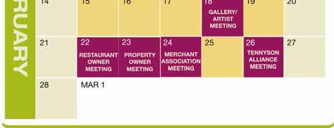
109 Task Force Meetings February 2010 TASK FORCE 4
110 Tennyson Street Process Overview Task Force Input Throughout Project TIMELINE / PROCESS 2
111 PROJECT CONTACT INFO: Q & A Jennifer Hillhouse City Project Manager Senior City Planner jennifer.hillhouse@denvergov.org Heather Noyes Parks & Gardens heather@parksandgardens.com Kristin Cypher Britina Design Group kristin@britina.com TASK FORCE 4
112 Project Overview & Summary of Existing Conditions
BUILDING SCALE AND SETBACKS 5 ELEMENTS:... 5 FAÇADES (COMMERCIAL/RESIDENTIAL) 5
 5") VISION STATEMENT 3 UTILIZATION OF THE GUIDELINES 3 IMPLEMENTATION 3 PROCEDURES FOR DESIGN REVIEW 3 LAND USE AND ZONING 4 LAND USE 4 ELEMENTS:... 4 ZONING 4 ELEMENTS:... 4 BUILDING SCALE AND SETBACKS 5
VISION STATEMENT 3 UTILIZATION OF THE GUIDELINES 3 IMPLEMENTATION 3 PROCEDURES FOR DESIGN REVIEW 3 LAND USE AND ZONING 4 LAND USE 4 ELEMENTS:... 4 ZONING 4 ELEMENTS:... 4 BUILDING SCALE AND SETBACKS 5
Table of Contents. Elm Avenue Improvement Plan City of Waco, Texas. Introduction 1. Existing Context 1 Figure 1 2.
 Table of Contents Introduction 1 Existing Context 1 Figure 1 2 Plan Guidelines 3 Future Urban Form 4 The West-End 4 Main Street 6 The East-End 7 Figure 2 9 Public Improvement Recommendations 7 General
R STREET CORRIDOR NEIGHBORHOOD Site Plan and Design Review Supplemental Guidelines Checklist
 R STREET CORRIDOR NEIGHBORHOOD Site Plan and Design Review Supplemental Guidelines Checklist Applicant s Name: Project Address: Phone: Email: Applicant shall fill out the design guidelines checklist for
The Lincoln Neighborhood Corridor Plan. The LiNC
 October 1, 2014 Planning Commission Study Session The Lincoln Neighborhood Corridor Plan The LiNC Purpose of Tonight s Meeting Introduction to The LiNC Review of Existing Conditions and Community Identified
VEHICULAR AND PEDESTRIAN CIRCULATION
 This perspective sketch communicates the intended character and quality of a proposed streetscape design. Locate benches near a major intersection where people tend to gather. Seating and lighting provide
4.9 Mendocino Avenue Corridor Plan Design Guidelines
 4.9 Mendocino Avenue Corridor Plan Design Guidelines The Mendocino Avenue Corridor Plan addresses the area between College Avenue and Steele Lane. Mendocino Avenue is a busy arterial that runs parallel
This Review Is Divided Into Two Phases:
 Semiahmoo Town Centre Review The purpose of this review: To review the Semiahmoo Town Centre Concept Plan, originally approved in 1993, to ensure that this centre will continue to serve the needs of South
Sheridan Boulevard S TAT I O N A R E A P L A N S H E R I D A N B O U L E VA R D S TAT I O N A R E A P L A N
 Sheridan Boulevard S TAT I O N A R E A P L A N 1 City of Lakewood Adopted November, 2006 S H E R I D A N B O U L E VA R D S TAT I O N A R E A P L A N The Vision The City of Lakewood s overall vision is
PUBLIC RIGHT-OF-WAY IN THIS CHAPTER PUBLIC REALM
 PUBLIC RIGHT-OF-WAY This section provides design guidelines for improvements in the public right-of-way. The public right-of-way refers to streets, sidewalks, non-vehicular thoroughfares, parks and greenways
FLORIN ROAD CORRIDOR Site Plan and Design Review Guidelines Checklist
 FLORIN ROAD CORRIDOR Site Plan and Design Review Guidelines Checklist Applicant s Name: Project Address: Phone: Email: Applicant shall fill out the design guidelines checklist for all guidelines applicable
Urban Design 9Identity
 Urban Design 9Identity URBAN DESIGN IDENTITY Urban design is about connecting people to their places through the built environment, nature, and overall urban form. Done well, it creates a memorable space
DRAFT. October Wheaton. Design Guidelines
 October 2011 DRAFT Wheaton Design Guidelines 2 Draft - Design Guidelines - Wheaton Sector Plan Contents 04 Section 1: Introduction 06 Section 2: Context 08 Section 3: Design Guidelines 09 Goal 1: Create
GREENING THE BOULEVARD Master Plan Concepts for Venice Boulevard between Lincoln and Sawtelle
 GREENING THE BOULEVARD Katherine Spitz Associates Inc. 4212½ Glencoe Avenue Marina Del Rey, CA 90292 310 574 4460 Fax 574 4462 January 2008 Table of Contents Overview Proposed Design Improvements Illustration
appendix and street interface guidelines
 appendix five: building and street interface guidelines appendix 5 building and street interface guidelines BOULEVARDS Boulevards are generally characterized by higher levels of traffic movement at higher
VISION AND GUIDING DESIGN PRINCIPLES
 pleasure point commercial corridor VISION AND GUIDING DESIGN PRINCIPLES Public Draft November 26, 2018 County of Santa Cruz with assistance from MIG CONTENTS PART I: INTRODUCTION AND VISION... 3 Community
Figure Example of out door dining in the public right-of-way.
 Section 2 Core Area Goal 2.2.1 To maintain and enhance the character of existing streets in the Downtown Area. Character Figure 2.2.1 Example of out door dining in the public right-of-way. A. Provide street
Chapter 1: Introduction
 Chapter 1: Introduction The Penn Avenue Community Works Corridor Vision and Implementation Framework presents an integrated communitybased vision and a coordinated, long-term implementation framework for
COMPLETE GREEN STREET CHECKLIST
 COMPLETE GREEN STREET CHECKLIST This document was developed to dissect the structure of an urban street and explore opportunities to make our streets more complete while also integrating green street strategies.
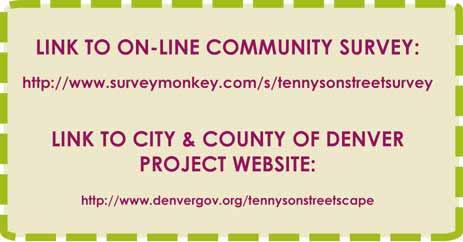
Tonight s Agenda. Summary Presentation Open House. Group Discussion Next Steps: online community wide survey
 Community Open House February 22, 2018 Tonight s Agenda Summary Presentation Open House Station 1: Project Overview and Community Input Station 2: Draft Vision and Guiding Principles Station 3: Western,
WEST LOOP DESIGN GUIDELINES CHECKLIST
 WEST LOOP DESIGN GUIDELINES CHECKLIST Section 1.0 General Strategies 1.1 DESIGN EXCELLENCE: ENCOURAGE HIGH QUALITY AND INNOVATIVE DESIGN OF NEW BUILDINGS WITHIN THE WEST LOOP WITHOUT BEING PRESCRIPTIVE
Wadsworth Boulevard S TAT I O N A R E A P L A N
 Wadsworth Boulevard S TAT I O N A R E A P L A N City of Lakewood Adopted November, 2006 The Vision The City of Lakewood s overall vision is to transform the area around the light rail station into a mixed-use
ARLINGTON COUNTY, VIRGINIA
 ARLINGTON COUNTY, VIRGINIA County Board Agenda Item Meeting October 15, 2005 DATE: September 28, 2005 SUBJECT: Request to Advertise the adoption of the 2005 Clarendon Sector Plan C. M. RECOMMENDATION:
PLAN ELEMENTS WORKSHOP. April 5, 2016
 PLAN ELEMENTS WORKSHOP April 5, 2016 needs more housing. But there is no one-size fits-all solution. Every neighborhood has its own character. In some places, density is not only appropriate it is badly
ARTICLE 6: Special and Planned Development Districts
 ARTICLE 6: Special and Planned Development Districts 6-10 Traditional Neighborhood Development (TND) District 6-10.10 Purpose and Intent The Traditional Neighborhood Development (TND) District provides
BUSINESS DISTRICT DESIGN GUIDELINES
 Des Plaines, Illinois Prepared for the City of Des Plaines by: The Lakota Group Laurie Marston, AICP March 2005 Section 5: Streetscape Elements Business District Design Guidelines STREETSCAPE ELEMENTS
Design Guidelines. Roosevelt. Mike Podowski DPD Design Guidelines Ordinance ATT 13 August 13, 2012 Version #1
 Roosevelt Design Guidelines The Roosevelt Neighborhood Design Guidelines apply within the Neighborhood Boundary. Map 1 2 Map 2 3 Map 3 4 CS1 Natural Systems and Site Features Citywide Guideline: Use natural
DRAFT. 10% Common Open Space
 % OF CHARLOTTE IS CATEGORIZED AS A. LAND USES : Placeholder map displaying location of Place Type GOALS: Accommodate XX% of future growth. Provide a concentration of primarily commercial and civic activity
Policies and Code Intent Sections Related to Town Center
 Policies and Code Intent Sections Related to Town Center The Town Center Vision is scattered throughout the Comprehensive Plan, development code and the 1994 Town Center Plan. What follows are sections
ZONING. 300 Attachment 1. City of Oneonta. Design Guidelines ( )
") 300 Attachment 1 City of Oneonta Design Guidelines ( 300-68) A. Site Organization. These guidelines address issues related to both building and parking location. Other issues include vehicle access (curb
300 Attachment 1 City of Oneonta Design Guidelines ( 300-68) A. Site Organization. These guidelines address issues related to both building and parking location. Other issues include vehicle access (curb
City of Farmington. Downtown Plan. Amendment to the 1998 Master Plan Adopted October 11, 2004
 City of Farmington Amendment to the 1998 Master Plan Adopted October 11, 2004 Introduction Planning Background 1 Scope and Components of the Plan Amendment 2 Concept Introduction 3 Plan Concepts 3 Conceptual
PIKE PINE RENAISSANCE: ACT ONE. October 19, 2017
 PIKE PINE RENAISSANCE: ACT ONE October 19, 2017 WATERFRONT SEATTLE PROGRAM PROJECT INTRODUCTION Pike and Pine streets, between First and Melrose avenues Pedestrian and streetscape improvements Budget:
LUNDY S LANE COMMUNITY IMPROVEMENT PLAN STUDY
 PUBLIC INFORMATION MEETING #2 October 12, 2016 LUNDY S LANE COMMUNITY IMPROVEMENT PLAN STUDY AGENDA 5:00 to 5:30pm: Open House 5:30 to 6:15pm: Presentation 6:15 to 7:00pm: Individual paced workshop with
Town Center (part of the Comprehensive Plan)
") Town Center (part of the Comprehensive Plan) Mercer Island Town Center Looking North (2014) In 1994, a year-long process culminated in a set of design guidelines and code requirements for the Town Center
Town Center (part of the Comprehensive Plan) Mercer Island Town Center Looking North (2014) In 1994, a year-long process culminated in a set of design guidelines and code requirements for the Town Center
Request Alternative Compliance to the prescribed criteria of the Oceanfront Resort District Form- Based Code. Staff Recommendation Approval
 Applicant Property Owner Steven H. Murden Public Hearing June 14, 2017 City Council Election District Beach Agenda Item 8 Request Alternative Compliance to the prescribed criteria of the Oceanfront Resort
STREETSCAPE IMPROVEMENTS - RECOMMENDATIONS
 STREETSCAPE IMPROVEMENTS - RECOMMENDATIONS Figure 4.3.1- A map of all of the recommended streetscape improvements. The key component of downtown s public realm, apart from its public spaces, is its street
Lower Merion Commercial Districts Issues and Characteristics Handbook November 2013
 Lower Merion Commercial Districts Issues and Characteristics Handbook November 2013 DRAFT TOWNSHIP-WIDE VISION: To maintain and enhance commercial areas to complement the surrounding high-quality residential
East Central Area Plan
 East Central Area Plan Steering Committee Meeting March 8 th, 2018 CHUN Tears McFarlane House Vision Statement Development Opportunities Analysis Vision Elements 1. Equitable, Affordable and Inclusive
CITY OF PUYALLUP. Background. Development Services
 CITY OF PUYALLUP Development Services 333 South Meridian Puyallup WA 98371 To: City Council From: Katie Baker, AICP, Planning Division Re: South Hill Neighborhood Plan Adoption Date: (Meeting date: February
Broadway Avenue Streetscape Project City of Albert Lea. Streetscape Design Committee Meeting October 29, 2012
 Broadway Avenue Streetscape Project City of Albert Lea Streetscape Design Committee Meeting October 29, 2012 1 Presentation Outline Street Widths, Sidewalk Widths and Bump-Out Configuration Decorative
5.0 WAYFINDING STREETSCAPE DESIGN MASTER PLAN 55
 OVERVIEW 57 SIGN TYPE A: GATEWAY 57 SIGN TYPES B & C: WAYFINDING KIOSKS & BOLLARDS 58 SIGN TYPES D: POLE MOUNTED ELEMENTS 59 SIGN TYPE E: LARGE-SCALE TYPOGRAPHIC INSTALLATION 60 SIGN TYPE F: VERTICAL CHOPSTICKS
Neighborhood Districts
 NEIGHBORHOOD DISTRICTS SEVEN MAIN DISTRICTS Neighborhood Districts While the Development Plan provides a broad-scale overview of the neighborhood, this section focuses on uses and relationships at the
EXISTING COMPREHENSIVE PLAN
 EXISTING COMPREHENSIVE PLAN Town Center Land Use Element: V. LAND USE POLICIES Town Center Mercer Island's business district vision as described in "Your Mercer Island Citizen-Designed Downtown" was an
, C-MS I June 3, 2016 $1500 pd chk #216918
 , C-MS-8 LOTS 21 THROUGH 40, INCLUSIVE, BLOCK 299 CLEMENTS ADDITION TO THE CITY OF DENVER SOUTHEAST QUARTER OF SECTION 34, TOWNSHIP 3 SOUTH, RANGE 68 WEST, SIXTH PRINCIPAL MERIDIAN, CITY
2. Form and Character. 2.1 Introduction. 2.2 The Downtown Addition Plan. 2.1 Introduction
 2.1 Introduction 2.1 Introduction This section of the Specific Plan describes and illustrates the desired form, character and uses of the Downtown Addition and explains the underlying design principles.
II. SINGLE FAMILY RESIDENTIAL
 II. SINGLE FAMILY RESIDENTIAL Castle Rock is made up of numerous individually built houses and subdivision tracts that have been developed during the past century. Some of the tracts are diverse in architectural
COMMUNITY DESIGN. GOAL: Create livable and attractive communities. Intent
 COMMUNITY DESIGN Intent An attractive, well-designed County will attract quality development, instill civic pride, improve the visual character of the community, and create a strong, positive image for
BRADENTON RIVERWALK EXPANSION MASTER PLAN
 BRADENTON RIVERWALK EXPANSION MASTER PLAN INTRODUCTION & AGENDA Process Update Community Engagement Summary Center for Active Design (CfAD) Recommendations Context and Existing Conditions Master Plan Alternatives
ORANGE LINE TRANSIT NEIGHBORHOOD PLANS VAN NUYS NEIGHBORHOOD COUNCIL, PLUM COMMITTEE DEPARTMENT OF CITY PLANNING, CITY OF LOS ANGELES
 Photo: Mission Meridian(Moule & Polyzoides) ORANGE LINE TRANSIT NEIGHBORHOOD PLANS VAN NUYS NEIGHBORHOOD COUNCIL, PLUM COMMITTEE DEPARTMENT OF CITY PLANNING, CITY OF LOS ANGELES JULY 18, 2018 Project partially
The open space system should provide connective elements, relate to natural resources, and enhance the suburban character of the landscape..
 The open space system should provide connective elements, relate to natural resources, and enhance the suburban character of the landscape.. Mixed-use and infill development should maintain or enhance
Summary of Public Input & Discussion of Alternatives
 Meeting #4 Summary of Public Input & Discussion of Alternatives May 6 th, 2009 City of Bellingham, Washington April 1 April 15 April 22 May 6 Introduction, Character and Boundary Study Areas Public Realm:
John Portman Boulevard Corridor
 Corridor Multi-use Path + Streetscape Improvements February 8, 13 SOUTH SIDE BLOCK IMPROVEMENT NOTES: Consolidation of Utility/Sign Locations Remove Existing Trees Centennial Olympic Park Drive Planter
open house 3 CITY OF SALEM Downtown Streetscape Plan
 open house 3 Streetscape concepts CITY OF SALEM Downtown Streetscape Plan analysis concepts we are here refined concepts & document Feb 13th 1 2 3 apr 18th KICKOFF OPEN HOUSE Streetscape Work Group Walking
The Baileys Planning District portion of the Comprehensive Plan contains site design recommendations for both the Baileys Crossroads Community
 The Baileys Planning District portion of the Comprehensive Plan contains site design recommendations for both the Baileys Crossroads Community Business Center and the Seven Corners Community Business Center.
Eastcreek Farm. Planned Development Standards September, 2014
 Eastcreek Farm Planned Development Standards September, 2014 ekfarm Contents 01. General Standards 02. Residential Development Standards 03. Architectural Design Standards 04. Landscape Design Standards
Highland Village Green Design Guidelines
 Highland Village Green Design Guidelines Publishing Information Title Highland Village Green Design Guidelins Author The City of Calgary Status DRAFT - Proposed document subject to changes Additional Copies
The Auburn Plan Designing the Future of Auburn February 28, 2005
 The Auburn Plan Designing the Future of Auburn February 28, 2005 Block-by-Block Bicycle Tour Aerial survey Focus Group Meetings September 7 and 8 Design Workshops October 11, 14, and 21 Revitalization
Appendix D North Road/N. Leroy Street Subarea Plan
 North Road/N. Leroy Street Subarea Plan INTRODUCTION The City of Fenton Master Plan was updated in 1996 and included a subarea plan for the North Leroy Street area of the City. It was recognized at that
Future Five. Design/ Development Guidelines. January 2008 Amended June 08 per City Council motion
 Future Five Design/ Development Guidelines January 2008 Amended June 08 per City Council motion 5-Points Design Guidelines Table of Contents I. Introduction 3 II. Area boundaries 4 III. Review Process
FRUITVALE TRANSIT VILLAGE (Phase 2) Residential Project
 Residential Project") FRUITVALE TRANSIT VILLAGE (Phase 2) Residential Project DEVELOPER: SIGNATURE PROPERTIES ARCHITECT: HKIT ARCHITECTS April 23, 2010 TABLE OF CONTENTS 3 Vision 4 Description of Site 5 Guiding Concepts 6
FRUITVALE TRANSIT VILLAGE (Phase 2) Residential Project DEVELOPER: SIGNATURE PROPERTIES ARCHITECT: HKIT ARCHITECTS April 23, 2010 TABLE OF CONTENTS 3 Vision 4 Description of Site 5 Guiding Concepts 6
chapter DESIGN GUIDELINES NEW RIVER MASTER PLAN REPORT
 chapter DESIGN GUIDELINES NEW RIVER MASTER PLAN REPORT .76 DESIGN GUIDELINES An Overview design guidelines NEW RIVER MASTER PLAN Design Guidelines can transform the image of a city. Specific, design-based
Complete Neighbourhood Guidelines Review Tool
 Complete Neighbourhood Guidelines Review Tool Prepared By: City of Regina Planning Department October 2014 Page 1 of 14 Community Development Review Checklist for Secondary Plans and Concept Plans The
Fifth and Detroit Street Design/South University Update Capital Improvement Committee Meeting
 1 Fifth and Detroit Street Design/South University Update Capital Improvement Committee Meeting Kick-off Meeting Agenda 2 1. Introductions 2. Update on South University 3. Fifth and Detroit-project scope
Planning Board Briefing
 Planning Board Briefing Why Now? The Sector Plan Implementation Chapter States: Before Stage 1 begins, the following must occur: Approval of the Sectional Map Amendment. Approval of the Greater Lyttonsville
STANDARD SPECIFICATIONS Book 2 ENGINEERING DRAWINGS INCLUDES ADDENDUMS
 STANDARD SPECIFICATIONS Book 2 ENGINEERING DRAWINGS INCLUDES ADDENDUMS July 23, 2018 Page 1 of 7 STANDARD LEGEND SYMBOLS (September, 1973)... AS-101A STANDARD LEGEND SYMBOLS (September, 1973)... AS-101B
Streets Vision
 streets 86 2.9 Vision : The Most Prevalent and Important Public Spaces Fixed routes of human travel have served as corridors for commerce and places for human interaction from the earliest trails and foot
Copyright, 2010 Hyperform Design Co-op, All Rights Reserved WEST COLFAX AVENUE GREEN PILOT: STREETSCAPE
 c Copyright, 2010 Hyperform Design Co-op, All Rights Reserved 2 Prepared for West Colfax Business Improvement District Prepared by Hyperform Design Co-op Hyperform Design Co-op 227 Broadway, Suite 205
ASPEN HILL Minor Master Plan Amendment
 ASPEN HILL Minor Master Plan Amendment Worksession #3 Planning Board Agenda Item #5 MONTGOMERY COUNTY PLANNING DEPARTMENT Maryland-National Capital Park and Planning Commission Area 2 Planning November
Johnson Street Bridge Public Realm Update
 Johnson Street Bridge Public Realm Update August 20, 2015 Background Johnson Street Bridge Replacement Project impacts a diverse range of stakeholders In addition to a new bridge, the project also includes
CHAPTER 7: Transportation, Mobility and Circulation
 AGLE AREA COMMUNITY Plan CHAPTER 7 CHAPTER 7: Transportation, Mobility and Circulation Transportation, Mobility and Circulation The purpose of the Transportation, Mobility and Circulation Chapter is to
Roanoke Rapids Streetscape Master Plan. City Council Presentation
 SCHEDULE: Stakeholder Meeting/Kick off November,2016 Master Planning Phase (November March 2017) Public Meeting #1 December 13, 2016 Review Meeting with Key Stakeholders Refine Concepts Based on Input
Community Design Plan
 Gardena General Plan 2006 Authority While the is not a required element of a General Plan, it is included because improving the community appearance and image is paramount to the overall quality of life
The Village. Chapter 3. Mixed Use Development Plan SPECIFIC PLAN
 The Village SPECIFIC PLAN Chapter 3 3.1 INTRODUCTION 3.1.1 Purpose This Chapter describes the development regulations applicable to the Mixed-Use and Transit Center Planning Areas. These form-based regulations
CENTERS AND CORRIDORS
 INITIAL DESIGN STANDARDS AND GUIDELINES for CENTERS AND CORRIDORS City of Spokane Planning Services Third Floor, City Hall 808 W. Spokane Falls Blvd. Spokane, WA 99201-3329 (509) 625-6300 www.spokaneplanning.org
P A I N E S V I L L E D O W N T O W N P L A N
 DEVELOPMENT YIELDS In addition to the qualitative aspects of the plan, it is important to understand the redevelopment concepts from a quantitative standpoint. How many new homes are being proposed p in
Public input has been an important part of the plan development process.
 Lakewood s Comprehensive Plan recognizes that transportation helps shape the community, and that the way the community provides for the safe and efficient movement of people affects the character of the
Community Engagement Committee Meeting #1 December 10, :30pm-8:30pm
 Community Engagement Committee Meeting #1 December 10, 2014 6:30pm-8:30pm Welcome and Introductions Dana Murdoch Minneapolis Park and Recreation Board Project Manager Ryan French Walker Art Center Director
SECTION TWO: Overall Design Guidelines
 SECTION TWO: Overall Design Guidelines This section provides overall design principles and guidelines for the Gardnerville Mixed-use Overlay. They provide criteria for mixed-use places consisting of residential,
Chapter 1.0 Introduction
 Chapter 1.0 Introduction 1.1 Background The North Metro commuter rail line is part of the RTD FasTracks regional transit system expansion program to build more than 100 miles of rail transit throughout
In surveys, Dallas residents say what they want to change most
 NEIGHBORHOODS ELEMENT In surveys, Dallas residents say what they want to change most in the city is its appearance they want it to look beautiful, with trees and pedestrian-friendly neighborhoods. The
4. INDUSTRIAL 53 CASTLE ROCK DESIGN
 4. INDUSTRIAL 53 CASTLE ROCK DESIGN CASTLE ROCK DESIGN 54 4. INDUSTRIAL Overview Well-designed and attractive industrial centers are the product of blending economic realities with both functional and
urban design Introduction
 ACHIEVE SP RI NGF I ELD.3 Introduction Urban Design Areas Design Areas are areas within Springfield that have a unique and recognizable character that is different from other areas in the community. The
Lehigh Acres Land Development Regulations Community Planning Project
 Lehigh Acres Land Development Regulations Planning Effort Summary In July, 2010 Commissioner Frank Mann invited the Lehigh Acres community to start discussing how to achieve their recently adopted community
Buildings may be set back to create small plazas provided that these setbacks do not substantially disrupt the street wall s continuity.
 6-22 Community Design Street Walls and Street-front Setbacks The siting of buildings will play a critical role in establishing the character and sense of place for the District. Siting buildings at the
I. Introduction. Prior Approvals
 Statement of Justification First National Bank 19790 Crystal Rock Drive, Germantown, Maryland Application for Site Plan and Limited Preliminary Plan Amendment I. Introduction DPH Architecture, for First
SEAPINES STATION DESIGN GUIDELINES CITY OF VIRGINIA BEACH MARCH 2017
 SEAPINES STATION DESIGN GUIDELINES CITY OF VIRGINIA BEACH MARCH 2017 CONTENTS DEFINITIONS... 2 BACKGROUND & PURPOSE... 3 LOCATION... 3 RECOMMENDED BUILDING PLACEMENT & SETBACKS... 5 RECOMMENDED CONCEPTS
East Bayshore Road Neighbourhood
 East Bayshore Road Neighbourhood Northridge Property Management Urban Design Brief 3195 East Bayshore Road City of Owen Sound January 2016 East Bayshore Road Neighbourhood Northridge Property Management
TOWN CENTER DESIGN STANDARDS FOR THE CITY OF. August, MOUNTLAKE TERRACE TOWN CENTER DESIGN STANDARDS August,
 TOWN CENTER DESIGN STANDARDS FOR THE CITY OF MOUNTLAKE TERRACE August, 2008 MOUNTLAKE TERRACE TOWN CENTER DESIGN STANDARDS August, 2008 1 TABLE OF CONTENTS Introduction...3 Design Site Design...4 Pedestrian
Carlsbad Village Redevelopment Concept Summary of Features
 Carlsbad Village Redevelopment Concept Summary of Features Calthorpe Associates November 5, 2003 The Redevelopment Concept illustrates a vision for the future of Carlsbad Village. The overall vision of
Rezoning Petition Post-Hearing Staff Analysis July 31, 2018
 Rezoning Petition 2017-050 Post-Hearing Staff Analysis July 31, 2018 REQUEST LOCATION Current Zoning: B-1 (neighborhood business) and O-1 (office) Proposed Zoning: NS (neighborhood services) Approximately
People who are members of historically disenfranchised racial, ethnic, cultural, and other identity groups are encouraged to apply.
 CALL TO ARTISTS REQUEST FOR QUALIFICATIONS CITY OF TACOMA MUNICIPAL ART PROGRAM East 64 th Streetscape, Tacoma, WA APPLICATION DEADLINE October 10, 2018, 11:59pm BUDGET $72,000, all-inclusive SUMMARY The
BROOKLYN PARK / 85TH AVE LRT STATION CDI DEVELOPMENT GUIDELINES DRAFT
 August 2018 Page intentionally left blank The Brooklyn Park Library adjacent to the 85th Ave LRT Station Area. OVERVIEW The Blue Line LRT Extension / Bottineau corridor offers a unique opportunity to leverage
5.1 Site Plan Guidelines
 5. Community Core Guidelines Development of the Community Core will take place by plan of subdivision and site plan approval. It will occur in a phased manner that will reflect the timing of residential
Othello Neighborhood Design Guidelines
 Othello Neighborhood Design Guidelines 1 S ORCAS ST S OTHELLO ST 42ND AVE S 2 Note: Design Review does not apply to all zones. See Citywide Guidelines for details. Additionally, zoning areas on this map
Presentation of the Staff Draft. July 17, 2014 SSRVP Team, Area 3
 Presentation of the Staff Draft July 17, 2014 SSRVP Team, Area 3 Presentation Overview Introduction Plan Framework Plan Recommendations Implementation Next Steps and Request for Public Hearing on September
Preliminary Sketch Plan for Fort Hunter Park
 Preliminary Sketch Plan for Fort Hunter Park Public Presentation November 19, 2009 Dauphin County Parks and Recreation 100 Fort Hunter Road Harrisburg, PA 17110 (717) 599-5188 www.dauphinc.org THOMAS COMITTA
4.1.3 LAND USE CATEGORIES
 4.1.3 LAND USE CATEGORIES a. City Center District The City Center District incorporates the existing character and mix of uses in downtown Belmont to encourage redevelopment and new development in keeping
Tonight s Agenda. 7:45 p.m. Next Steps 8:00 p.m. Close
 Community Workshop #3 January 28, 2016 Team Tonight s Agenda 6:00 p.m. Welcome and Introductions! 6:15 p.m. Draft Specific Plan Overview Project Process Update Vision and Objectives Overview Key Findings
University of the District of Columbia Van Ness Campus Master Plan Community Open House 3. December 8, 2010
 University of the District of Columbia Van Ness Campus Master Plan Open House 3 December 8, 2010 Introductions Sequence of Work: Campus Master Plan BEGIN: INTRODUCE AND START WORK Project Initiation Team
NORTHGATE AREA. Design Guidelines. Effective, final draft: 2 may 02. City of Seattle Department of Design, Construction & Land Use
 NORTHGATE AREA neighborhood urban village Design Guidelines Effective, final draft: 2 may 02 City of Seattle Department of Design, Construction & Land Use Design Review: Northgate Area Neighborhood Design
Metro. Activity Center Design Guidelines. Recommendations For Developing Focused, Mixed-Use Commercial/Residential Centers
 Metro Activity Center Design Guidelines Recommendations For Developing Focused, Mixed-Use Commercial/Residential Centers Metro Activity Centers What is a MAC? Legacy, the adopted guide for the future growth