Best Development Practices
|
|
|
- Griffin Simpson
- 5 years ago
- Views:
Transcription

1 Town of Franklin Best Development Practices Version 1, November 2001 Guidebook
2 Table of Contents INTRODUCTION I. CHECKLIST FOR DESIGNERS ERS II. STORMWATER MANAGEMENT a. Overview and Policies b. Summary of Practices c. Discussion of Practices Vegetated Swales Vegetated Filter Strips Constructed Wetlands Bioretention Cells (Rain Gardens) Pervious Paving Surfaces Roof Gardens Retention Basins Detention Basins Catch Basins and Drain Pipes III. EROSION AND SEDIMENTATION CONTROL a. Site Planning b. Construction Period Impacts Soil Stabilization Sediment Retention Perimeter Protection Other Practices IV. LANDSCAPE DESIGN a. Water-Sensitive Landscaping b. Plant Species Native Species Salt Tolerant Species Urban Tolerant Species Species for Erosion Control Wetland Species Moist Tolerant Species Drought Tolerant Species Habitat Creating Species Invasive Species V. SITE PLANNING APPENDIX A... A ENDNOTES Franklin Best Development Practices Guidebook Page i
3 Introduction The Franklin Best Development Practices Guidebook (BDP Guidebook) is a set of guidelines for developers, designers and project reviewers intended to improve the quality of development in Franklin. The Guidebook describes the required and preferred design and construction practices in Franklin related to stormwater management, erosion and sedimentation control, landscape design, and site planning. Any project proposed in Franklin that requires Planning Board or Zoning Board of Appeals (ZBA) approval shall comply with the requirements of this Guidebook. None of the practices in the Guidebook are new, and many have already been used extensively in Massachusetts. The Guidebook codifies these practices as official Town policy, thus taking some of the guesswork out of project design and review. The Guidebook also provides a single-source reference book for designers and reviewers working in Franklin. Recognizing that many best development practices are site-dependent, the Guidebook identifies a range of practices that are relevant to development and redevelopment projects on a variety of sites. The Guidebook is divided into five sections. Section I is a checklist cklist for designers to help them determine which best development practices are likely to be applicable to their project. Project reviewers will also use this checklist to assess the project s compliance with the requirements of the BDP Guidebook. Sections II through V discuss best development practices related to stormwater management, erosion and sedimentation control, landscape design, and site planning. These four sections describe the best development practices that are applicable in different situations and some technical details of the practices. References are provided for those who seek more information and design specifications for the various practices. Thank you for taking the time to read this Guidebook. With your participation, the Town of Franklin will become a model for attractive and environmentally responsible community development. Franklin Best Development Practices Guidebook Page 1
4
5 I. Checklist for Designers The Checklist for Designers is a summary of the best development practices that this Guidebook requires or recommends, and when they should be used. Prior to submitting an application for review, the applicant shall fill out this checklist to verify that he or she has complied with Franklin s policies and planned the development or redevelopment site in way that furthers the goals discussed below. The checklist shall then be submitted with the application. The Planning Board and/or ZBA and their technical consultants will use the checklist to evaluate whether the application complies with this Guidebook. Franklin Best Development Practices Guidebook Page 3
6 Checklist for Designers Page 1 of 4 Stormwater Management GOALS and NEEDS addressed: 1. Protect local and regional wetlands and water bodies 2. Maximize groundwater recharge to retain a viable local groundwater supply 3. Ensure that Franklin complies with the EPA Stormwater Phase II Requirements FRANKLIN POLICIES: (A) All new development projects in Franklin shall meet the following three stormwater management performance standards. All redevelopment projects shall meet the standards to the maximum feasible extent, and, if they fail to meet the standards, shall retrofit or expand existing stormwater management systems to improve existing conditions. (B) 1. Post-development peak discharge rates from the site shall not exceed pre-development peak discharge rates from the site. 2. Annual groundwater recharge from the post-development site shall approximate annual recharge from the pre-development site. 3. The stormwater management system shall remove at least 80% of the average annual load of total suspended solids (TSS) from the post-development stormwater created on developed site. Non-structural stormwater management systems should be used wherever site conditions allow, as outlined in the Guidebook. Drain pipe/catch basin systems may be used, in part or in whole, only if the applicant can demonstrate that other systems are not feasible due to site conditions. BEST DEVELOPMENT PRACTICES One or more of the following must be used to meet the above policies. Incorporated into Project? Vegetated swales (recommended to collect runoff from roadways & parking lots) [ Vegetated filter strips (recommended to filter and infiltrate runoff from roadways, parking lots, and driveways; use with (a) along roadsides and parking lots) Constructed wetlands (preferred method for stormwater retention & pollutant removal) [ Bioretention cells (recommended on residential lots and parking lot islands) [ Pervious paving surfaces (recommended in overflow parking and low-traffic areas) [ Roof gardens (encouraged on flat commercial and industrial rooftops) [ Retention basins (less preferred method for stormwater retention & pollutant removal) [ Detention basins (may be used in series with other practices, such as constructed wetlands, to provide pre-treatment) Drain pipe/catch basin systems (discouraged, unless other stormwater collection and conveyance systems have been demonstrated not to be feasible due to site conditions) Have you documented that other systems are infeasible? [ [ [ [ Franklin Best Development Practices Guidebook Page 4
7 Checklist for Designers Page 2 of 4 Erosion and Sedimentation Control GOALS and NEEDS addressed: 1. Minimize erosion 2. Prevent sedimentation of water bodies and its attendant environmental impacts FRANKLIN POLICIES: (A) Any proposed project on a previously undeveloped site shall accommodate the development program in a way that minimizes clearing and regrading, especially in areas of steep slopes, erosionprone soils, or sensitive vegetation. For redevelopment projects, the site plan shall concentrate development in previously-disturbed areas to the extent possible. (B) As a condition of approval, every proposed project shall submit and adhere to a construction management plan that addresses soil stabilization, sediment retention, perimeter protection, construction scheduling, traffic area stabilization and dust control. BEST DEVELOPMENT PRACTICES The applicant must comply with all of the following requirements. Incorporated into Project? Clearing and regrading have been minimized [ Development is focused in previously disturbed areas (for redevelopment projects) [ A construction management plan has been prepared p [ The construction management plan addresses: Soil stabilization (cover or stabilize erodible surfaces not in immediate use) Sediment retention (runoff interceptors and sediment traps/ponds) Perimeter protection (vegetated buffers or silt fences at the limit of work) Construction scheduling (minimize disturbed area at any given time) Traffic area stabilization (crushed rock or similar at construction vehicle entrance and parking areas) Dust control (plan for stabilizing dusty surfaces when necessary) [ [ [ [ [ [ Franklin Best Development Practices Guidebook Page 5
8 Checklist for Designers Page 3 of 4 Landscape Design GOALS and NEEDS addressed: 1. Minimize demand for irrigation water 2. Maximize groundwater recharge from landscaped areas 3. Preserve native biodiversity by retaining habitat and defending against invasive species 4. Maximize the value to wildlife of human-managed landscapes FRANKLIN POLICIES: (A) Site plans and landscape plans for all proposed projects shall take appropriate steps, as outlined in the Guidebook, to minimize water use for irrigation and to allow for natural recharge of groundwater. (B) Landscape plans shall follow the guidelines in the Guidebook for selecting species that are most appropriate to the site conditions. Native species and habitat-creating species shall be used in all landscape plans to the maximum extent possible while still meeting the site s landscaping needs. Invasive species identified in this Guidebook may not be planted in Franklin under any condition. BEST DEVELOPMENT PRACTICES The applicant must comply with all of the following requirements. Clearing and regrading have been minimized (natural vegetation must be retained to the maximum extent possible, given the development program) Irrigation, if present, is water efficient (if an in-ground irrigation systems is proposed, it is a water efficient system with automatic sensors to prevent overwatering) Incorporated into Project? Landscaped areas retain water (gardens are mulched and designed for water infiltration) [ No invasive species are used (species from the invasive species list may not be used) [ Native and habitat-creating species are used (species from these lists have been incorporated into the landscape design whenever possible) Species are appropriate to the soil, site, and microclimate conditions (select appropriate species from the lists of salt-tolerant, urban-tolerant, wetland, moist-tolerant and drought-tolerant species) [ [ [ [ Franklin Best Development Practices Guidebook Page 6
9 Checklist for Designers Page 4 of 4 Site Planning GOALS and NEEDS addressed: 1. Protect Franklin s natural environment, including habitat, water resources, and ecosystem services 2. Create a visually appealing community 3. Preserve the Town s historic and cultural heritage 4. Stabilize and increase property values 5. Encourage sustainable development FRANKLIN POLICY: Subdivision plans and site plans for all forms of development shall adhere to the principles of environmental compatibility, aesthetic compatibility, and energy-efficient design. BEST DEVELOPMENT PRACTICES The site plan must address all of the following principles. Unique natural features have been preserved (the development program should avoid or else showcase significant natural features) Historic and cultural resources have been preserved (the development program should avoid or else showcase significant historic and cultural features) Incorporated into Project? Clearing, grading, and building placement consider viewsheds [ Cut and fill have been minimized [ Buildings blend into the natural topography [ Buildings are oriented to the sun and wind for maximum energy efficiency Vegetated protection from northwest (winter) winds is provided Deciduous species planted or retained close to the E, S and W building edges [ [ [ [ Franklin Best Development Practices Guidebook Page 7
10
11 II. Stormwater Management a. Overview and Policies The need for a strong and innovative stormwater management policy is based on Franklin s attempt to address several challenges: Franklin has numerous wetlands and water bodies, and is at the headwaters of the Charles River, all of which are affected by polluted runoff. The Town relies on local groundwater aquifers for its public water supply; with Franklin facing seasonal water shortages, groundwater recharge is an essential function. The U.S. Environmental Protection Agency (EPA) has recently promulgated the so-called Stormwater Phase II Requirements, which require communities like Franklin to manage polluted runoff effectively. 1 (Notes and references are provided in the endnotes.) In order to ensure a minimum level of stormwater management for development and redevelopment projects, Franklin has adopted the following stormwater management performance standards. 2 The adoption of performance standards allows the design engineer to select one or more stormwater management systems that are most appropriate and cost-effective for the particular site. FRANKLIN POLICY: All new development projects in Franklin must meet the following three stormwater management performance standards. All redevelopment projects shall meet the standards and if they fail to meet the standards, shall retrofit or expand existing stormwater management systems to improve existing conditions. 1. Post-development peak discharge rates from the site shall not exceed pre-development peak discharge rates from the site. 2. Annual groundwater recharge from the post-development site shall approximate annual recharge from the pre-development site. 3. The stormwater management system shall remove at least 80% of the average annual load of total suspended solids (TSS) from the post-development stormwater created on developed site. There is a growing realization among water resource professionals that conventional systems of stormwater collection, conveyance, and end-of-the-pipe dry-basin detention are no longer sufficient to improve the water quality of surface water bodies. Therefore, the Town s general preference is that stormwater be conveyed and treated in natural and vegetated systems such as vegetated swales, filter strips, constructed wetlands, and bioretention cells. While some of these practices may be new to the Town of Franklin, they have been used successfully in other towns and states and have gained support from the EPA because of their generally superior performance FRANKLIN POLICY: Non-structural stormwater management systems should be used wherever site conditions allow, as outlined in the Guidebook. Drain pipe/catch basin systems may be used, in part or in whole, only if the applicant can demonstrate that other systems are not feasible due to site conditions. Franklin Best Development Practices Guidebook Page 9
12 in attenuating peak runoff rates, filtering pollutants, recharging groundwater, and allowing retention of the natural landscape. Recognizing that non-structural systems are not appropriate in all situations, the Guidebook also discusses other practices that will be permissible in certain situations. This section of the Guidebook discusses nine stormwater management practices that can be used, alone or in combination, to meet the performance standards. Other systems not discussed in this guidebook may also be acceptable if the applicant can demonstrate their fulfillment of the above standards. Table 2-1 provides a summary of the practices discussed in this chapter and when each practice is encouraged or allowed. Table 2-1: 2 Use of Stormwater Management Practices in Franklin Practice Franklin s Policy Appropriate Uses Vegetated Swales Strongly encouraged Roadsides, parking lots Vegetated Filter Strips Strongly encouraged Roadsides, residential frontage areas, parking lots, perimeter protection Constructed Wetlands Strongly encouraged Commercial and industrial sites, office campuses, subdivisions Bioretention Cells (Rain Gardens) Strongly encouraged Residential lots, parking lot islands Pervious Paving Surfaces Encouraged Parking overflow areas Roof Gardens Encouraged Office/industrial buildings Retention Basins Neutral Subdivisions, office developments Detention Basins Drain Pipe/Catch Basin System Allowed in combination with other practices Allowed when other systems are not practical due to site constraints All areas of development, if necessary All areas of development, if necessary There are several factors to consider when deciding on which practice(s) to implement in any given project. Among these factors are the space required, soils and slopes on site, depth to the water table, maintenance requirements, pollutant removal efficiencies, cost, and ability to meet Franklin s stormwater performance standards. Franklin Best Development Practices Guidebook Page 10
13 b. Summary of Practices Table 2-2 provides a summary of design and site considerations for the various stormwater management systems. Table 2-2: 2 2: Design and Site Considerations for Stormwater ter Practices 3 Space Required Soils Slope of Catchment Area Water Table and Bedrock Proximity to Building Foundations Vegetated Swales Bottom width: 2 ft. min. 6 ft. max. Permeable soils perform better, but wet swales can be used in less permeable soils A design consideration, but usually not a limitation Generally not a constraint Min. 10 ft. down-gradient from buildings & foundations recom d Vegetated Filter Strips Recommended minimum width: ft. Permeable soils perform better, but soils are not a limitation A design consideration, but usually not a limitation Generally not a constraint Min. 10 ft. downgradient from buildings & foundations recom d Constructed Wetlands 5% of drainage area Soils are not a limitation Max. 15% for forested; 5% for shrubs/ herbs Water table should be at or near soil surface, or else a liner can be used Min. distance 10 ft. Bioretention Cells Min width: 5-10 ft Min length: ft Min. depth: 2-4 ft Permeable soils recom d (infilt. rates >0.27 in/hr). Underdrains allow for less permeable soils. A design consideration, but usually not a limitation 2-4 ft above water table/bedrock recommended Min. 10 ft. downgradient from buildings & foundations recom d Max. Depth N/A N/A 4-6 ft. 2-4 ft., depending on soil type Maintenance Requirement Low: routine landscape maint. Low: routine landscape maint. Moderate; depends on sediment n rate Low: property owner can include in normal site landscape maint. Pervious Paving Not a factor Permeable soils perform better Usually not a limitation 2-5 ft above water table/ bedrock recom d Not a factor Retention Basins Min. pool surface: 0.25 acres recom d Detention Basins 1 acre foot per 4 acres drainage area Catch Basins Not a factor Not a factor Not a factor Not a factor Maximum 15% Not a factor Min. distance of 10 ft Maximum 15% Generally not a constraint Min. distance of 10 ft. Not a factor Not a factor Not a factor N/A 3-6 ft ft. N/A Low: routine landscape maint. Moderate; depends on sediment n rate Moderate: routine sediment removal Moderate: routine sediment removal Franklin Best Development Practices Guidebook Page 11
14 Table 2-3 should be used in determining compliance with Franklin s 80% TSS removal standard. TSS removal efficiency for each of the various stormwater management systems shall be presumed to be the value shown in Table 2-3 unless the applicant can provide additional satisfactory information or documentation that the system has a greater TSS removal efficiency. Other systems not discussed in this Guidebook may also be acceptable if the applicant can demonstrate their fulfillment of the Franklin stormwater management performance standards. If more than one practice is used to achieve the required 80% TSS removal, the removal efficiency rates must be multiplied together, not added. For example, if the first practice has a 60% TSS removal rate and the second practice has a 20% removal rate, a total of only 68% of TSS would be removed. (60% of the total, plus 20% of the remaining 40% of TSS.) Table 2-3: 2 TSS Removal Rates for Stormwater Management Practices 4 Practice Design Rate for TSS Removal (use this number to calculate compliance with the 80% TSS removal requirement) Vegetated swale 70% 60-80% Range of Average TSS Removal Rates Vegetated filter strip 30% per 10 of width a 30-65%, depending on width Constructed wetland b 80% 65-80% Bioretention cell 80% c 65-80% Retention basin b 70% 60-80% Detention basin d 60% 60-80% Deep sump and hooded catch basin 25% 25% w/cleanout a For widths greater than 10, TSS removal is determined multiplicatively. For example, for a 30 wide strip, the TSS removal rate would be (1- (0.7*0.7*0.7)) = 66%. b Must have sediment forebay or pre-treatment. c If an underdrain is used, the water must be conveyed to a secondary treatment device such as a constructed wetland or a retention basin. d Post-treatment is required (e.g., by a constructed wetland or retention basin). Franklin Best Development Practices Guidebook Page 12

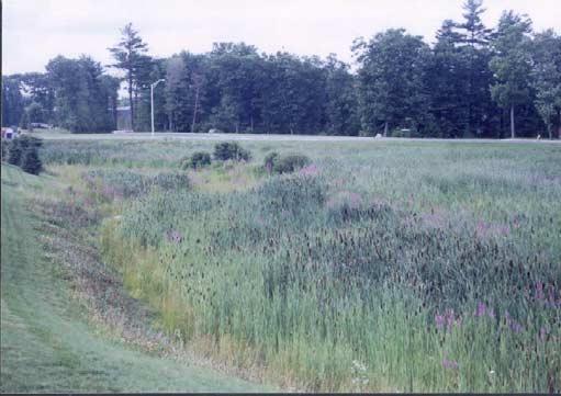
15 c. Discussion of Practices Each of the nine stormwater management practices is discussed in more detail below. References in the endnotes provide additional information on the use, design, and construction of these practices. 1. Vegetated Swales Swales are earthen channels most commonly covered with a dense growth of grass or other vegetation, and are designed primarily to control water quantity and quality. 5 The design of vegetated swales has improved over the years, enabling engineers and hydrologists to implement them for a variety of different purposes. Depending on hydrological conditions and design, swales can be dry, wet, or grassed: Dry swales are channels filled with approximately 30 inches of soil (50% sand and 50% loam) that allows full infiltration of the stormwater. Wet swales are generally used when the water table is at or near the soil surface or when soils are poorly drained. Theses swales have a ponding area that should be planted with moist-tolerant species to enhance nutrient uptake and sediment retention. Grassed swales are planted with grass species that provide a dense cover and serve to provide sediment retention, nutrient uptake and filtration. They are suitable for sandy loam soils. Pollutants are removed from stormwater by the filtering action of the grass, sediment deposition, and/or infiltration into the soil. Grass swales are designed to remain dry most of the time and are specifically planted with species to enhance nutrient uptake and filtration. Design Considerations Swales are easily implemented on large lot residential sites (½ to 1 acre or larger), office and industrial campuses, roadways where right-ofway widths are adequate, and parking lot medians and edges (see photo at left). Ideally, stormwater should flow from the impervious surface through a vegetated filter strip before entering the swales (see Figure 2-2). Typically, dry and grass swales are used for low density residential projects or very small impervious areas and require soils that have infiltration rates of inches per hour. Wet swales, Figure 2-1: A grass swale surrounding a parking lot on the other hand, are convenient for treating highway runoff in low lying or flat terrain areas and need to be planted with water tolerant vegetation. Swales should be built at a gentle slope so that water flows at a relatively low velocity. The minimum allowable slope is ½%, while the maximum slope is based on velocity. Water velocity in the swale should generally not exceed 3 feet per second, which typically corresponds to a Franklin Best Development Practices Guidebook Page 13
16 maximum slope of about 5%. If necessary, the swale may be steeper in places, provided that riprap or other stabilization is used to prevent scouring and erosion within the swale. The side slopes should be at a maximum of 3:1, and the length of the swale should be calculated to accommodate the entire calculated runoff volume from a 10-year storm. Regular maintenance such as mowing, sodding, and repair of eroded areas is necessary for swales. In addition, the accumulated sediment may need to be periodically removed, particularly during the construction and early site stabilization periods. Franklin Best Development Practices Guidebook Page 14
17 2. Vegetated Filter Strips Filter strips are typically bands of close-growing vegetation, placed between pollutant source areas and the receiving water body (either a natural water body or a constructed swale). To protect natural water bodies (e.g., streams or wetlands), filter strips should consist of natural buffer strips already existing on the site. Not only do filter strips protect sensitive areas such as wetlands, woodlands and erodible soils; they also reduce runoff impacts by trapping sediment and sediment-bound pollutants, provide some infiltration, and slow and disperse stormwater flow over a wide area. 6 Figure 2-2 illustrates some of the biochemical processes by which filter strips remove pollutants. 7 Figure 2-2: Processes by which vegetated filters remove pollutants Design Considerations Treatment of stormwater in filter strips is accomplished physically by a combination of filtration through the standing vegetation and infiltration into the underlying soils. In order to treat stormwater effectively, filter strips must be designed to function as overland flow systems where stormwater is evenly distributed. Because there is a high potential for short-circuiting of the filter strips and reduced pollutant removal, grading must be designed carefully to provide uniform flow into the filter strips. If filter strips are wide enough and planted with appropriate plant species, they will provide wildlife habitat as well as visual amenities in the landscape. It is important to note that filter strips are usually implemented in combination with other stormwater management facilities that specifically control stormwater volume. Finally, for a filter strip to be efficient, a minimum width of feet is recommended. Upkeep of filter strips should be incorporated into routine landscape maintenance, which would include raking the filter strip, removing large trash or debris that has accumulated, and regularly cleaning up sediment. Franklin Best Development Practices Guidebook Page 15
18 3. Constructed Wetlands Constructed wetlands (or stormwater wetlands) are shallow pools that create growing conditions suitable for marsh plants. These systems are designed to maximize pollutant removal through retention, settling, and uptake by wetland plants. 8 Stormwater wetlands serve several benefits simultaneously. The primary purpose of constructed wetlands is to improve water quality by removing sediment and pollutants. However, these wetlands can also provide excellent habitat for wildlife and waterfowl. In general, a constructed wetland would be a suitable stormwater management practice for residential subdivisions and commercial developments. Figure 2-3: A constructed wetland Design Considerations Constructed wetlands must be designed with consideration to the size of the contributing watershed area, amount of baseflow, soil type, and available space. The contributing watershed may be as small as 5 acres; however, the smaller the watershed area, the more difficult it is to create sufficient drainage and runoff to keep the wetland perpetually wet. Since wetlands need to maintain soil moisture throughout the year, it is important to have a dry-weather baseflow or a groundwater supply. The preferred soil types for constructed wetlands are less-permeable soils that have relatively small pores and are less prone to evaporation. The surface area of constructed wetlands should be at least 1% of the contributing drainage area, and the wetlands should have a length to width ratio of at least 1.5:1. 9 In order to increase the efficiency of the retention pond, a sediment forebay must be incorporated as a pretreatment device. As with all other stormwater management practices, stormwater wetlands also require ongoing maintenance to retain their maximum effectiveness. However, several design features can decrease the amount of maintenance that a wetland needs. For example, a reverse-slope pipe or a weir outlet with a trash rack should be used to prevent clogging of the outlet; orifices should have diameters no less than 3 ; and direct maintenance access should be provided to the forebay to allow for sediment removal. Selection of plant species is one of the most important parts of creating a stormwater wetland, as the plants are largely responsible for the pollutant and sediment retention and uptake. Please refer to Figure for a sample wetland vegetation layout and Section III for a list of plant species suitable for planting in constructed wetlands. Franklin Best Development Practices Guidebook Page 16
19 Figure 2-4: Sample wetland vegetation layout Franklin Best Development Practices Guidebook Page 17
, biological degradation")
.")
20 4. Bioretention Cells (Rain Gardens) Bioretention cells (otherwise known as rain gardens) are landscaped areas that mimic upland vegetation systems. These systems are designed to trap stormwater, infiltrate it, and treat it by means of vegetational uptake (uptake of certain minerals and nutrients by vegetation), biological degradation (microbial/bacterial metabolic activities), and/or gravitational sediment removal. Runoff is conveyed as sheet flow to the treatment area, which consists of a grass buffer strip, sand bed, ponding area, organic layer or mulch layer, planting soil, and plants (see Figure ). Runoff passes first over or through a sand bed, which slows the runoff and distributes it evenly along the ponding area. The ponding area is made up of a surface organic layer, ground cover and the underlying planting soil. The ponding area is graded such that there is a depression in the middle where water remains until it infiltrates or evaporates. The depression should be designed to hold up to 6 inches of water. 12 An overflow structure should be provided for situations where the ponding area is not sufficient. As shown in Figure 2-7, the infiltrated water may also be collected through an underdrain and outlet, which would drain water to a constructed wetland or retention pond Figure 2-5: A bioretention cell on a residential lot for further treatment. Bioretention cells can be used in both residential and commercial projects. In residential subdivisions, bioretention cells are used to retain and infiltrate stormwater locally so that it does not need to be conveyed and treated by means of a more extensive stormwater management system. Each residential lot would typically have one or more bioretention cells (which are essentially landscaped gardens) that receive stormwater from the roof and driveway and infiltrate it to the ground. Each homeowner is responsible for maintaining the bioretention cell(s) on their property, just as they would maintain their garden. In commercial projects, bioretention cells are installed as depressed islands in the parking lot. Stormwater is directed to these islands, where it is treated and infiltrates into the ground. Figure 2-6: Bioretention cell in a parking lot Franklin Best Development Practices Guidebook Page 18

21 Figure 2-7: Bioretention cell Design Considerations The design of bioretention cells must consider the site area, slope, soils, groundwater, and maintenance needs. Figure illustrates a typical bioretention cell installation. Bioretention cells should be designed to occupy 5 to 7 percent of the drainage area multiplied by the rational method runoff coefficient ( c ) determined for the site. 14 Recommended minimum dimensions are 15 feet by 40 feet for bioretention cells receiving parking lot runoff. Bioretention cells on individual house lots can be much smaller. The site should have shallow slopes (approximately 5% or less) so that water flow is guaranteed but velocity is not too high. An underdrain should be used in situations where soils are tight and there is a concern about the cell backing up or flooding. (In areas of less pervious soils, bioretention cells may be constructed by importing more permeable soils for the cell itself, in combination with an underdrain which prevents water from ponding above a less permeable natural soil layer.) An underdrain should also be used where the water table is close to the surface and there is a concern about groundwater pollution. In other situations, an underdrain generally is not needed. Bioretention cells need to be maintained regularly to ensure the presence of mulch and good soil, attend to any diseased or dead plants, and remove collected sediment, litter and debris. Franklin Best Development Practices Guidebook Page 19
22 Figure 2-8: Typical design layout of a bioretention cell. Franklin Best Development Practices Guidebook Page 20

23 5. Pervious Paving Surfaces Pervious paving surfaces typically consist of a permeable surface with an underlying crushed/broken stone reservoir to temporarily store runoff before it infiltrates into the ground. The main purposes of this application are to reduce the amount of stormwater runoff from paved areas and to infiltrate stormwater into the underlying soils. By reducing the amount of stormwater runoff, pervious paving surfaces reduce the cost of stormwater management. Pervious paving surfaces that are now available include porous asphalt, pervious concrete and grass pavers. Porous asphalt and pervious concrete appear to be the same as traditional pavement from the surface, but incorporate void spaces to allow infiltration. These systems have been applied successfully in a few locations in New England where soils consist of particularly well-drained sands and gravels that allow the pores to drain rapidly. However, in areas of tighter soils, porous asphalt and pervious concrete are generally not recommended in this region because water remaining in the void areas is subject to the freeze-thaw cycle which stresses and weakens the pavement. Figure 2-9: Grass pavers Grass pavers, shown in Figure 2-9, are a viable option in New England s climate. 15 Grass pavers consist of concrete interlocking blocks or a synthetic fibrous gridded system with open areas designed to allow grass to grow. The design should allow for infiltration into the underlying soils so that stormwater does not pond near the surface. Design Considerations Grass pavers are most suitable for low-traffic areas such as the overflow areas of commercial or office parking lots, residential driveways, and service areas that will be subject to light traffic. Franklin recommends their use in these situations. If these systems are used, stormwater calculations should account for the reduced amount of runoff generated by areas with grass pavers. In general, grass paver systems should not be salted in the winter because this will threaten the viability of the plants. However, salting will not typically be required in the low-traffic areas where grass pavers are recommended. Franklin Best Development Practices Guidebook Page 21


24 6. Roof Gardens Roof gardens are precultivated vegetation mats placed on several layers including a fertilizer layer, a substrate mat, a protective fleece and an impervious membrane. Roof gardens provide several functional benefits such as reducing stormwater runoff volume and pollutant load, increasing the energy efficiency of buildings, improving air quality by removing particles in the air and by photosynthesis, and increasing the aesthetic value of the area. Roof gardens can be built on almost any rooftop, from a residential building to a commercial or industrial building. Figure 2-10 shows a typical application. 16 The Town of Franklin recommends that roof gardens be used in large commercial, office, and institutional buildings that have flat roofs. Figure 2-10: A roof garden in Stuttgart, Germany Once established, roof gardens do not need extensive maintenance other than occasional fertilization and weeding. During the initial stage some watering might be required; however, usually within six months the plants are able to sustain themselves. Since the soil layer is not deep, it will not support tall vertical growth or large plants; therefore, cutting or mowing is not required. Load reserves of at least 15 pounds per square feet beyond snow load requirements are needed to install a roof garden. 17 If properly built over a suitable roofing membrane, roof gardens do not present a leaking problem. Figure 2-11: Typical roof garden design Franklin Best Development Practices Guidebook Page 22

25 7. Retention Basins Retention basins are constructed to have a permanent pool of water to treat stormwater. The pool allows settling of sediments, removal of soluble pollutants by algal uptake, and some groundwater recharge as shown in Figure The basins are designed to include additional storage capacity to control peak discharge rates. The primary component of a retention basin is a deep, permanent pool, but the basin may also include a shallow marsh or a sediment forebay to increase sediment and nutrient removal. 19 In general, the Town of Franklin does not recommend that retention basins be used as the primary means of attenuating peak runoff rates or removing pollutants. Constructed wetlands are generally a preferred system since they have greater pollutant uptake functions. However, retention basins may be used in subdivisions as well as commercial and industrial areas when other stormwater management systems are not feasible or sufficient because of site conditions or the nature of the development program. Retention basins may also be used in series with constructed wetlands as a sediment trap, particularly during construction. Design Considerations Retention basins must drain a sufficiently large area to maintain a permanent pool of water. The minimum recommended area is Figure 2-12: Retention basin typically around 10 acres, assuming impervious surface percentages typical of suburban developments. 20 Within the watershed area that drains to the retention basin, the slopes and the stormwater conveyance system must result in a metered flow of stormwater that does not flood the basin all at once. The use of filter strips and swales can help slow and infiltrate water on its way to the basin. Retention basins can be constructed in a wide range of soil types. However, when native soils have a rapid percolation rate, soils should be compacted or supplemented sufficiently so that the pond does not dry up during the dry season. The soils should retain sufficient infiltration potential so that the pond also continues to play a role in groundwater recharge. In order to increase the efficiency of the retention basin, a sediment forebay must be incorporated as a pretreatment device. As with constructed wetlands, retention basins should use non-clogging outlets and large orifices (not less than 3 inches in diameter), and should provide easy dredging access to reduce long-term maintenance requirements and difficulties. Franklin Best Development Practices Guidebook Page 23
26 8. Detention Basins Detention basins are depressed areas whose outlets have been designed to detain stormwater runoff for some minimum time to allow particles and associated pollutants to settle. Since the aim of detention basins is mainly to control flooding and remove sediments, they do need not to have a permanent pool and therefore can be dry during non-flood conditions. Typically, they are used in conjunction with other stormwater management systems such as retention basins or constructed wetlands as a primary treatment. The Town of Franklin discourages the use of detention basins as the primary means of flood control. Instead, vegetated swales and filter strips should be used whenever possible to attenuate peak runoff rates. When site characteristics do not allow use of such practices, however, detention basins may be considered as part of the stormwater management system. In addition, detention basins may be used as a pre-treatment device to settle out particulates prior to discharge to a constructed wetland or retention basin, where additional treatment and infiltration will occur. Figure 2-13: Schematic design of a dry extended detention pond Design Considerations Detention basins are most practical for use on sites that are at least 10 acres, which allows for the use of larger outlet orifices that are less likely to clog. Detention basins can be used on sites with a slope of up to about 15 percent. There is no minimum slope requirement, provided that there is enough change in elevation to ensure flow. Soil type is not a factor except in areas with rapidly percolating soils such as sand. In these areas, an impermeable liner should be used to prevent groundwater contamination from untreated runoff. Detention basins should be designed with sediment forebays, which allows sediment to be trapped prior to entering the detention basin. This feature also reduces maintenance requirements for the detention basin. As with constructed Franklin Best Development Practices Guidebook Page 24
27 wetlands, detention basins should use non-clogging outlets and large orifices (not less than 3 inches in diameter), and should provide easy dredging access to reduce long-term maintenance requirements and difficulties. Any detention basin in the Town of Franklin must provide landscaping and planting to minimize its visual impacts. The plants selected for the ponding area should be able to withstand both wet and dry periods. Along the perimeter of the basin, however, the plants should be adapted to dry conditions and should create a visual vegetated buffer. Franklin Best Development Practices Guidebook Page 25
. In most cases a hood is also included to separate oil and grease from the stormwater.")
28 9. Catch Basins and Drain Pipes Catch basins are storm drains that capture and roughly filter stormwater through a grate or curb inlet and capture sediment, debris and associated pollutants in a deep sump (Figure ). In most cases a hood is also included to separate oil and grease from the stormwater. The essential function of a catch basin is to act as a pretreatment device for other structures incorporated into a storm sewer system. The performance of a catch basin in removing sediment and pollutants will depend greatly on the size of the drainage area, the size of the sump, and the amount of maintenance it receives. Although catch basins are currently used in virtually all circumstances, they typically cannot remove pollutants as well as most of the other practices mentioned in this section and require frequent maintenance. Catch basins should only be used when the other practices mentioned in this section prove unfeasible. The designer must document the reason(s) why the other practices are not feasible before the use of catch basins may be approved. Figure 2-14: A catch basin inlet When catch basins are used, the Town will consider it preferable if they discharge individually or in pairs to nearby swales, constructed wetlands, or bioretention cells, rather than carrying runoff further to a larger retention/infiltration system. Lengthy catch basin-piped drain-manhole networks are discouraged. In general, the goal is to use vegetated, low-velocity channels to hold and infiltrate stormwater locally, not to efficiently capture and deliver stormwater to watercourses. Design Considerations Catch basins should be designed to hold a combined volume of at least 400 cubic feet per acre of contributing impervious area and have sumps that are at least four feet deep. The grates and inlets should be sized and constructed to pass the 10-year storm volume into the deep sump. Flow from the catch basin/drain pipe system should be directed to another stormwater management device, such as a constructed wetland, for further treatment. Catch basin inlets should be cleaned regularly (at least twice a year) and after large storms. Removed sediment should be disposed of in accordance with applicable local, state and federal guidelines and regulations. Franklin Best Development Practices Guidebook Page 26
29 III. Erosion and Sedimentation Control Erosion and sedimentation control practices should be incorporated into the planning, construction, and operation of any project in Franklin. Specific measures must be presented for review prior to construction. a. Site Planning The most important erosion control practice is to minimize clearing and regrading, as discussed in Section V, V Site Planning. FRANKLIN POLICY: Any proposed project on a previously undeveloped site must accommodate the development program in a way that minimizes clearing and regrading, especially in areas of steep slopes, erosion-prone soils, or sensitive vegetation. For redevelopment projects, the site plan should concentrate development in previously-disturbed areas to the extent possible. The initial step to control erosion and sedimentation lies in developing a plan that is appropriate to the site features including topography, soils, drainage ways, and natural vegetation. The site planning process should begin with a thorough evaluation of sensitive areas requiring protection as well as less sensitive areas suitable for development. The site plan should delineate a limit of work that limits clearing and regrading and protects the most sensitive areas, based on the criteria in Table 3-1. For example, in residential subdivisions, native vegetation should be retained on individual houselots to the extent possible, rather than creating larger lawns. Table 3-1: 3 Guidelines for identifying sensitive site features 22 Topography Slopes that are steeper and/or longer typically create more erosion. Slopes that exceed the following thresholds are likely to be sensitive and erosion-prone: Slopes of 5-7% longer than 300 feet Slopes of 7-15% longer than 150 feet Slopes of more than 15% longer than 75 feet Drainage Where possible, retain natural drainage ways and depressions and utilize for stormwater conveyance Soils Consider factors such as erodibility, permeability, depth to water table and bedrock, and soils with shrink/swell potential or slippage tendencies. The most erodible soils contain high proportions of silt and very fine sand. The presence of clay or organic matter tends to decrease erodibility. Natural vegetation This is the most important factor in preventing erosion. Vegetated buffers filter runoff, decreasing runoff velocity, and increase infiltration capacity. Franklin Best Development Practices Guidebook Page 27
30 b. Construction Period Impacts Prior to the commencement of construction, the limit of clearing and limit of work identified on the site plan and approved by the Town must be suitably marked. Acceptable markers include survey tape or plastic fences. These markers are in addition to any fences that the Conservation Commission may require for sensitive areas such as wetlands, streams and their buffers. Construction activities and construction traffic must be limited to the area identified on the site plan, and no stockpiling of materials, soils, or debris or other activity may occur outside of the limit of work. FRANKLIN POLICY: As a condition of approval, every proposed project must submit and adhere to a construction management plan that addresses soil stabilization, sediment retention, perimeter protection, construction scheduling, traffic area stabilization and dust control. Franklin Best Development Practices Guidebook Page 28

31 1. Soil Stabilization The construction management plan should outline a plan for cover and/or stabilization of erodible surfaces that are not the immediate focus of construction activity. The Town requires covering and stabilization as a way of minimizing soil erosion as well as sedimentation in the Town s water bodies and storm sewer system. Cover measures must be implemented on areas that have already been disturbed but will not be worked on during the next 7 days during dry conditions or next 2 days during wet conditions. Acceptable cover methods include, but are not limited to, the use of mulch, erosion control nets and blankets, plastic covering, seeding and sodding. These are described in the following paragraphs. Mulching is generally considered to be a suitable short-term protective measure. The main purpose of mulching is to protect the site from erosion by stabilizing soils and reducing stormwater runoff velocity. Mulch can also enhance plant establishment by conserving moisture, holding fertilizer, seed and topsoil in place, and moderating soil temperature. The most commonly used mulches include straw, wood fiber or cellulose, compost and wood chips. The effectiveness of mulching depends on site characteristics and maintenance: if the site is prone to high winds or has steep slopes, additional steps should be taken to anchor the mulch, such as planting vegetation or providing netting or blanketing. The thickness of the cover should be maintained at all times and any area that has eroded should be remulched and anchored until it has been stabilized. Similar to mulching, plastic covering is also acceptable as a short-term protective measure. This technique simply involves covering the area of concern with a plastic sheet and using tires or sandbags to weight the plastic down. Plastic covering is generally used on cut and fill slopes and stockpiles. Plastic covering should not be used if there is a sensitive area located downslope, because of the rapid runoff created by the plastic covering. Although this Figure 3-1: Geotextiles used for stabilizing a hillside is a fairly easy technique to apply, it requires careful maintenance. The plastic cover can easily be torn or damaged by the sun and can clog drainage systems if not removed properly. Therefore, regular maintenance should be provided to ensure that the plastic is undamaged at all times and fully removed after it is no longer needed. Seeding, sodding and erosion nets and blankets are usually more appropriate as long-term solutions for areas that will remain unworked for months. Section IV lists recommended species to plant for erosion control purposes. A well-designed landscaping plan can easily incorporate areas of planting for permanent erosion control. If the area must be stabilized immediately, then the use of sodding is more appropriate since it can provide immediate erosion protection. Sodding is appropriate for use on residential or commercial lawns, steeply-sloped areas, waterways and channels carrying intermittent flow, and areas around drop inlets that require stabilization. 23 Sod maintenance is essential during the establishment period. Sod should be Franklin Best Development Practices Guidebook Page 29
32 provided with adequate moisture and fertilizer. If the sod does not root and stay healthy, it should be replaced by new sodding or a different technique. Erosion control nets or blankets, also referred to as geotextiles, are another suitable long-term stabilization technique (see Figure ). Geotextiles are used for preventing erosion and holding seed and mulch in place on steep slopes, as well as in channels to aid vegetation establishment. Geotextiles can be made of synthetic materials such as polypropylene, polyester, polyethylene, nylon, and polyvinyl chloride as well as biodegradable materials such as mulch matting, jute, coconut fiber and other wood fibers. For effective stabilization, good contact with the ground must be maintained and no erosion should occur beneath the net or blanket. Synthetic geotextiles can be sensitive to light and wind; therefore, they should be inspected regularly and any problematic areas should be repaired immediately. Franklin Best Development Practices Guidebook Page 30
33 2. Sediment Retention Sediment retention from construction sites is a three-step process. First, all surface runoff from disturbed areas must be intercepted since this runoff contains high sediment loads. Second, the runoff must be conveyed to a sediment trap or pond where sediment removal will occur. Finally, the cleaned runoff must be discharged downslope of any disturbed areas. Typically, interceptor dikes and swales are used to intercept runoff; check dams are used to reduce flow velocity and remove sediment; ditches and pipes are used to convey the runoff; and riprap or level spreaders are used to dissipate runoff velocity in a non-erosive manner. As shown in Figure , interceptor dikes can collect the runoff and direct it to pipes and/or ditches which can convey the runoff to a sediment pond. The outflow from the pond can be connected to a stream (as shown in this case) or to a vegetated area. Riprap may be used to stabilize outlets. Check dams can be incorporated into the design to reduce the velocity of the runoff. Typically, check dams are installed in swales or ditches and consist of small gravel, rock, sandbag, log or straw dams. Figure 3-2: Sample sediment retention plan As mentioned above, sediment must be conveyed to sediment traps or ponds prior to being discharged. Sediment traps should be used for areas less than about three acres, and sediment ponds should be used for larger areas. Stormwater runoff is conveyed through these structures, where sediment is settled (mostly small particles of 0.02 mm or so) and turbidity is slightly reduced. 26 When sediment reaches one foot in depth, the trap or the pond should be cleaned. Any embankments or slopes should also be routinely checked and any damage properly repaired. The construction management plan must state how surface runoff will be intercepted and settled before it is released into the ground or off-site. Franklin Best Development Practices Guidebook Page 31
34 3. Perimeter Protection While interceptors and sediment traps/ponds discussed above will provide the primary sediment retention on construction sites, perimeter protection is also required to prevent residual sedimentation of adjacent lands and waters. The construction management plan should identify measures to prevent sediment from being transported off of the site. Again, the purpose of this requirement is to minimize sedimentation in the Town s water bodies, storm sewer system, and adjacent properties. Measures such as vegetated filter strips, silt fences, or brush barriers should be provided at the limit of work to filter runoff and capture sediment. In places where the limit of work is not near the edge of the site, a natural vegetation buffer of 40 feet is generally considered to be an acceptable retention system, except where the natural vegetation is a wetland, a wetland buffer or otherwise sensitive landscape feature, in which case a silt fence or similar device should generally be used. Figure illustrates proper installation of hay bales for sediment retention purposes. Figure 3-3: Installation of hay bales for sediment retention purposes Franklin Best Development Practices Guidebook Page 32
35 4. Other Practices Scheduling of Operations The construction management plan should state when clearing, grubbing, grading, construction, and replanting will occur on each section of the site. If construction phasing has not been determined at the time of the initial permitting, this section of the construction management plan may be submitted later, but must be submitted at least 60 days prior to the desired commencement of construction. Construction must be phased by area so that the smallest practical area of land is exposed for the shortest possible time. Traffic Area Stabilization To reduce the amount of sediment transported off site by construction vehicles and to reduce the erosion of areas disturbed by vehicle traffic, roads and parking areas should be stabilized immediately after initial grading. Not only will this stabilization reduce amount of sediment transported out of the site; it will also reduce the amount of easily erodible mud that forms on site. Stabilization can be achieved by use of a 6 inch deep layer of crushed rock, gravel base, or crushed surfacing base on the area of construction entrances or roads and parking areas. For any area that will be subject to long-term or high-volume construction vehicle traffic, a truck wash should be implemented, with dirty water channeled through sediment traps or ponds prior to discharge. Dust Control The construction management plan should commit to minimizing wind transport of dust from exposed soil surfaces onto roadways, drainage ways, and surfaces waters by spraying exposed soils with water until they are sufficiently damp so as to not produce dust, but not so wet as to produce runoff, whenever weather conditions are dry and windy. Franklin Best Development Practices Guidebook Page 33
36
37 IV. Landscape Design This section of the Guidebook addresses three critical goals for the Town: stabilizing water use at a sustainable level; creating landscapes that minimize natural habitat destruction and maximize habitat value; and encouraging the development of landscapes that provide environmental quality and visual relief. a. Water-Sensitive Landscaping Franklin currently suffers from a seasonal water supply shortage due in large part to lawn and garden watering. At the same time, development and the attendant rise in impervious surfaces is altering the natural hydrological cycle and reducing recharge to the aquifers. Without careful attention to water use and hydrologic systems, Franklin could face continued water shortages as well as large future expenditures related to public water supply. FRANKLIN POLICY: Site plans and landscape plans for all proposed projects must take appropriate steps, as outlined in this section, to minimize water use for irrigation and to allow for natural recharge of groundwater. On previously undeveloped ( greenfield ) sites, the most important water-sensitive practice is to minimize the disturbance and clearing of natural vegetation. Guidelines to meet this objective are provided in Section III and Section V of this Guidebook. Typically, this will mean preserving some portion of the site as open space, plus reducing the area of lawn and garden in favor of native vegetation in both residential and commercial/industrial projects. In places where native vegetation is cleared, at least some of the area should function as a groundwater recharge system. For example, a landscaped garden could function as a bioretention cell through appropriate subsurface design and selection of species, or portions of a lawn could serve as a vegetated filter strips for driveway runoff if properly graded. In general, the landscape design should aim to: Retain and recharge water onsite; Preserve existing vegetation to the maximum extent possible; Preserve soil permeability during development; and Minimize the use of turf grass in landscaping, opting instead for a variety of native species. To keep the water onsite, impervious areas need to be reduced to the maximum extent practical. Planting beds should be designed to conserve the water they receive. This can be achieved by grading the beds so that slope is gradual and stormwater runoff will have more time to percolate into the soil, and by using plant species that do not require large amounts of water. To meet its water conservation objectives, Franklin discourages in-ground irrigation systems. However, if irrigation systems are proposed, they shall be water-efficient drip systems or soil soakers equipped with automatic sensors that prevent watering when soils are already wet, or when it is raining. Drip irrigation is defined as the frequent slow application of water to a very small area in the root zone of the plant. Water slowly drips through either porous plastic pipes or emitters located below the soil surface. Drip systems have been found to reduce water use by 20-50%. 28 Soil soakers consist of long plastic or canvas tubes perforated with tiny holes through which the water seeps as a fine mist. Soil soakers are connected to a garden hose and can be left in place on the surface of the planting bed or buried under the mulch. Franklin Best Development Practices Guidebook Page 35
38 For garden areas, landscape plans should specify the use of a suitable mulch. Use of mulch is beneficial for several reasons. Mulch layers: Help capture moisture for vegetation that would normally be lost through evaporation; Prevent erosion by protecting the soil surface from raindrop impacts and by reducing the velocity of overland flow; Help prevent crusting, sealing and compaction of the surface, thereby preserving the infiltration rate; Protect seeds by forming an insulating layer against extreme heat and cold and by creating a suitable microclimate for seed germination; and Reduce weed growth and the need for herbicide application. 29 Good mulching materials include compost, pine bark, pine straw (pine needle bales), leaf mold, rotted manure, lawn clippings, aged and shredded hardwood bark, aged wood chips, and straw or chopped hay. b. Plant Species In the interest of striking an appropriate balance between community development and conservation, the Town of Franklin is committed to retaining natural habitats and habitat functions on developed sites to the maximum extent possible. In addition, to further the Town s water conservation goals, drought-tolerant species should be used in appropriate situations. FRANKLIN POLICY: Landscape plans shall follow the guidelines in this section for selecting species that are most appropriate to the site conditions. Native species and habitat-creating species shall be used in all landscape plans to the maximum extent possible. Invasive species identified in this section shall not be planted in Franklin under any condition. Landscape designers working on Franklin projects should use the following lists to select the most appropriate species for each portion of their site. Recognizing that many species are well-suited to several circumstances, there is much overlap among the nine lists of species provided below. Each list is also divided into different forms of plants, such as shade trees, ornamental trees, evergreen trees, deciduous shrubs, groundcovers, and flowers. The lists are not all-inclusive, and landscape designers may propose the use of other species not included here, provided they are not invasive species. However, these lists are intended to provide a sufficiently wide range of species that the Town considers generally acceptable under different circumstances. Information in this list is based on several sources including 974 CMR 3.05, 30 a wetlands creation manual, 31 landscaping catalogs, 32,33 and professional landscape architects and biologists. Franklin Best Development Practices Guidebook Page 36
39 1. Native Species The following species are native to Franklin and well-adapted to the area s climate. Many of the species also provide good wildlife habitat value. Shade Trees Acer rubrum Red Maple Acer saccharum Sugar Maple Betula lenta F Sweet Birch F Betula alleghaniensis F Yellow Birch F Betula papyrifera Paper Birch Carya ovata + Shagbark Hickory + Castanea dentate American Chestnut Fagus grandifolia American Beech Fraxinus americana White Ash Fraxinus pennsylvanica Green Ash Juglans cinerea + Butternut + Liquidambar styraciflua F Sweetgum F Liriodendron tulipifera F Tulip Tree F Nyssa sylvatica Black Tupelo Platanus occidentalis American Sycamore Quercus alba +F White Oak +F Quercus bicolor +F Swamp White Oak +F Quercus coccinea +F Scarlet Oak +F Quercus palustris +F Pin Oak +F Quercus rubra Northern Red Oak Salix nigra Black Willow Sassafras albidum Common Sassafras Tilia americana Redmond Redmond Linden Ulmus americana, disease-resist. var. American Elm Notes: + Recommended for planting on the portions of the site away from walks or roads. F These trees need extra care if they are planted during the fall season. ^ Canadian Hemlock is currently under attack by an insect that has no predator. Evergreen Trees Ilex opaca Juniperus virginiana Pinus rigida Pinus strobus Thuja occidentalis Tsuga canadensis American Holly Eastern Red Cedar Pitch Pine Eastern White Pine American Arborvitae Canadian Hemlock^ Franklin Best Development Practices Guidebook Page 37
40 Ornamental Trees Alnus rugosa Speckled Alder Notes: Amelanchier canadensis Shadblow Serviceberry ^ Cornus florida has been Amelanchier laevis Allegany Serviceberry adversely affected by an Betula nigra F River Birch F anthracnose epidemic in the Betula papyrifera F Paper Birch F Northeast U.S. in the past two Carpinus caroliniana F American Hornbeam F decades. Anthracnose spreads Cercis canadensis Eastern Redbud rapidly to other flowering Cornus alternifolia F Pagoda Dogwood F dogwoods. Before using this Cornus florida ^F Flowering Dogwood ^ F species, check with local Crataegus punctata Dotted Hawthorn agricultural extensions for the Hamamelis virginiana Common Witchhazel status of anthracnose. F Larix laracina American Larch These trees need extra care if Larix decidua European Larch they are ` planted during the fall Ostrya virginiana Hop Hornbeam season. Prunus pennsylvanica F Pin Cherry F Prunus virginiana F Common Chokecherry F Salix discolor Pussy Willow Viburnum lentago Nannyberry Viburnum Deciduous Shrubs Arctostaphylos uva-ursi Aronia melanocarpa Clethra alnifolia Comptonia peregrina Cornus alterniflora Cornus amomum Cornus racemosa Cornus rugosa Ilex verticillata Lindera benzoin Myrica pennsylvanica Azalea nudiflorum Rhododendron roseum Rhododendron viscosum Rhus glabra Rhus typhina Rosa carolina Rubus odoratus Sambucus canadensis Vaccinium corymbosum Viburnum acerifolium Viburnum cassinoides Viburnum dentatum Viburnum trilobum Evergreen Shrubs Juniperus communis 'Compressa' Kalmia angustifolia Kalmia latifolia Taxus canadensis Bearberry Black Chokeberry Summersweet Clethra Sweetfern Pagoda Dogwood Silky Dogwood Gray Dogwood Redleaf Dogwood Common Winterberry Common Spicebush Northern Bayberry Early Deciduous Pink Azalea Roseshell Azalea Swamp Azalea Smooth Sumac Staghorn Sumac Carolina Rose Flowering Raspberry American Elder Highbush Blueberry Mapleleaf Viburnum Witherod Viburnum Arrowwood Viburnum American Cranberrybush Viburnum Common Juniper Sheeplaurel Mountainlaurel Canadian Yew Franklin Best Development Practices Guidebook Page 38
41 Groundcovers Cornus canadensis Gaultheria procumbens Mitchella repens Vaccinium angustifolium Vaccinium macrocarpum Meadow Grasses/Wildflowers Festuca elatior Lolium perenne Sorghastrum nutans Panicum Andropogon gerardii Vitman Schizachyrium scoparium Calamagrostis canadensis Antennaria alpina Aristida dichotoma Aster linariifolius Eragrostis spectabilis Houstonia caerulea Juncus bufonius Senecio aureus Bunchberry Dogwood Checkerberry Wintergreen Partridgeberry Lowbush Blueberry Cranberry Tall Fescue Palmer II Perr. Ryegrass Indian Grass Blackwell Switchgrass Big Bluestem Little Bluestem Blue Joint Reedgrass Alpine Pussy-Toes Poverty Grass Bristly Aster Purple Lovegrass Bluets Toad Rush Golden Ragwort Franklin Best Development Practices Guidebook Page 39
42 2. Salt Tolerant Species These species are well-suited to roadsides and other locations that are likely to collect salty winter runoff. Shade Trees Acer campestre Aesculus hippocastanum Betula lenta* F Betula alleghaniensis* F Fraxinus americana* Gleditsia triacanthos inermis Nyssa sylvatica* Quercus alba*+ Quercus macrocarpa+ Quercus robur+ Quercus rubra Ulmus glabra Ulmus pumila Ornamental Trees Amelanchier canadensis* Betula papyrifera* F Betula populifolia* F Prunus pennsylvanica* F Prunus virginiana* F Pyrus calleryana F Pyrus calleryana 'Bradford' Salix discolor* Evergreen Trees Juniperus virginiana* Picea pungens 'glauca' Pinus nigra Pinus ponderosa Pinus rigida* Deciduous Shrubs Arctostaphylos uva-ursi* Aronia melanocarpa* Aronia prunifolia* Hippophae rhamnoides Lindera benzoin* Myrica pennsylvanica* Rhus glabra* Rhus typhina* Salix humilis* Salix lucida* Shepherdia argentea Tamarix ramosissima Hedge Maple Horse-chestnut Sweet Birch* F Yellow Birch* F White Ash* Thornless Honeylocust Black Tupelo* White Oak*+ Bur Oak+ English Oak+ Red Oak Scotch Elm Siberian Elm Shadblow Serviceberry* Paper Birch* F Gray Birch* F Pin Cherry* F Common Chokecherry* F Callery Pear F Bradford Pear Pussy Willow* Eastern Red Cedar* Blue Colorado Spruce Austrian Pine Ponderosa Pine Pitch pine* Bearberry* Black Chokeberry* Purplefruit Chokeberry* Common Seabuckthorn Common Spicebush* Northern Bayberry* Smooth Sumac* Staghorn Sumac* Prairie Willow* Shining Willow* Buffaloberry Five Stamen Tamarisk Notes: * Native Plants + Recommended for planting on portions of the site away from walks or roads. F These trees need extra care if they are planted during the fall season. Franklin Best Development Practices Guidebook Page 40
43 Vaccinium corymbosum* Viburnum cassinoides* Viburnum dentatum* Evergreen Shrubs Pinus mugo Taxus canadensis* Groundcovers Vaccinium angustifolium* Vaccnium palladum Highbush Blueberry* Witherod Viburnum* Arrowwood Viburnum* Mugo Pine Canadian Yew* Late Lowbush Blueberry* Early Lowbush Blueberry Notes: * Native Plants + Recommended for planting on portions of the site away from walks or roads. F These trees need extra care if they are planted during the fall season. 3. Urban Tolerant Species These species are suitable for planting in high-stress environments where there will be pavement within the tree s drip line, high levels of pedestrian or vehicular traffic, vehicle exhaust and air pollution, or other urban stressors. For example, most of these species are generally well-suited to being planted in parking lot islands or other narrow landscaped areas. Shade Trees Acer campestre Hedge Maple Acer rubrum* Red Maple* Acer saccharum* Sugar Maple* Carpinus betulus fastigiata F Pyramidal European Hornbeam F Celtis occidentalis Hackberry Cladastris lutea Yellowwood Corylus colurna Turkish Hazelnut Eucommia ulmoides Hardy Rubber Tree Fraxinus pennsylvanica* Green Ash* Gingko biloba Maidenhair Tree (female +) Gleditsia triacanthos inermis Thornless Honeylocust Liquidambar styraciflua* F Sweet Gum* F Maclura pomifera inermis 'Park' Park Osage Orange Nyssa sylvatica* Black Tupelo* Platanus acerifolia F London Plane Tree F Sophora japonica Scholartree Tilia cordata Littleleaf Linden Zelkova serrata F Japanese Zelkova F Notes: * Native Plants + Recommended for planting on portions of the site away from walks or roads. F These trees need extra care if they are planted during the fall season. Ornamental Trees Betula nigra* F Cercidiphyllum japonicum Chionanthus virginicus Cornus kousa F Crataegus phaenopyrum Magnolia stellata F Ostrya virginiana* Oxydendron arboreum F River Birch* F Katsuratree White Fringetree Kousa Dogwood F Washington Hawthorn Star Magnolia F American Hophornbeam* Sourwood F Franklin Best Development Practices Guidebook Page 41
44 Prunus sargentii F Pyrus calleryana F Syringa reticulata Deciduous Shrubs Cornus sericea Ilex verticillata* Ilex verticillata 'Nana'* Rhus aromatica 'Gro-low' Spiraea bumalda varieties Vaccinium angustifolium* Groundcovers Cotoneaster horizontalis Hedera helix Juniperus chinensis sargentii Juniperus horizontalis varieties Vinca minor Pachysandra terminalis Sargent Cherry F Callery Pear F Japanese Tree Lilac Red Osier Dogwood Common Winterberry* Dwarf Winterberry* Dwarf Fragrant Sumac Spirea Lowbush Blueberry* Rockspray Cotoneaster English Ivy Sargent Juniper Creeping Juniper Periwinkle Japanese Pachysandra 4. Species for Erosion Control These species can be used for stabilizing the ground and preventing erosion, and should be considered for planting in areas with steep slopes or unstable, erodible soils. Aegopodioum podagraria Variegatum Celastrus scandens Clematis paniculata Cornus, shrubby types Cotoneaster, low types Cytisus spp. Erica spp. Euonymus fortunei Colorata and cvs. Forsythia suspensa and cvs. Genista x Lydia Hedera helix and cvs. Hemerocallis, all Houtuynia cordata Chameleon Itea spp. Juniperus, low types Ligustrum, all Myrica pensylvanica Parthenocissus spp. Polygonum aubertii Rhus aromatica and cvs. Rosa, most Salix purpurea Stephanandra incisa Symphoricarpos x chenaultii Hancock Vinca minor and cvs. Yucca filamentosa Variegated Snow-on-the-Mountain American Bittersweet Clematis Dogwood (Silky, Gray-stemmed, Gray, Redleaf) Cotoneaster Scotch Broom Heath Wintercreeper Weeping Forsythia Genista lydia English Ivy Daylilly Chaeleon Houtuynia Sweetspire Juniper Privet Northern Bayberry Ivy Silver-vine Fleeceflower Fragrant Sumac Most roses Purpleosier Willow Cutleaf Stephanandra Chenault Coralberry Periwinkle Yucca Franklin Best Development Practices Guidebook Page 42
45 5. Wetland Species This list of species is generally well-suited for planting in constructed wetlands, wet swales, and other stormwater management areas that will typically be wet. Plantings in each section of the wet area must be selected according to the hydrological conditions in that area. See Figure 2-4 for a sample wetland planting layout. Herbaceous Plants Water Depth (see below) Osmunda cinnamomea Cinnamon fern Transitional Osmunda regalis Royal fern Transitional Symplocarpus foetidus Skunk cabbage Transitional Scirpus cyperinus Woolgrass Shallow Thelypteris palustri Marsh fern Shallow Caltha leptosepala Marsh Marigold Shallow Polygonum coccineum Pennsylvania smartweed Shallow Lobelia cardinalis Cardinal Flower Shallow Lobelia siphilitica Great Lobelia Shallow Iris versicolor Blue Flag Iris Medium Acorus calamus Sweet flag Medium Calla palustris Water arum Medium Sparganium eurycarpum Burreed Medium Scirpus americanus Three-square Medium Scirpus fluviatilis River bulrush Medium Sagittaria latifolia Arrowhead Medium Ponetederia cordata Pickerelweed Medium Peltandra cordata Arrow arum Medium Potamogeton pectinatus Sago pondweed Deep Vallisneria americana Tapegrass Deep Ranunculus flabellaris Yellow water buttercup Deep Ranunculus aquatilis White water buttercup Deep Scirpus validus Bulrush Deep Nymphea odorata Fragrant white lily Deep Nuphar luteum Spatterdock Deep Brasenia schrebrri Watershield Deep Transitional: seasonally flooded; Shallow: seasonally flooded to permanently flooded to 15 cm; Medium: 15 to 50-cm water depths; Deep: 50 to 200-cm water depths. Shrubs Clethra alnifolia Cornus amomum Ilex verticillata Kalmia angustifolia Lindera benzoin Rhodendron viscosum Viburnum recognitum Vaccinium corymbosum Summersweet Clethra Silky Dogwood Winterberry Sheep Laurel Spicebush Swamp Azalea Northern Arrowwood Highbush Blueberry Franklin Best Development Practices Guidebook Page 43
46 Trees Nyssa sylvatica Black gum Quercus bicolor Swamp oak Fraxinus americana + White ash + Fraxinus pennsylvanica* Green Ash* Acer rubrum + Red Maple + Quercus bicolor^ Swamp oak^ Betula nigra^ River birch^ Notes: *Species that will tolerate flooding for more than 1 year + Species that will tolerate flooding for one growing season ^Species that will tolerate flooding for less than 30 days during the growing season Woody Wetland Plants Salix nigra* Black Willow* Cephalanthus occidentalis* Buttonbush* Cornus stolonifera* Red-osier Dogwood* Sambucus canadensis + Elder + Vaccinium corymbosum + Blueberry + Chamaecyparis thyoides + Atlantic white cedar + Alnus rugosa + Spackled Alder + Nyssa sylvatica^ Black gum^ Ilex opaca^ American Holly^ 6. Moist Tolerant Species These species require significant moisture, and many are adapted to survive periods of standing water. In general, these species should only be planted where local soil and topography produce moist conditions. Landscape designers should not rely upon irrigation to sustain these species. Woody Plants Acer negundo Acer rubrum Alnus rugosa Amelanchier Andromeda polifolia Aralia spinosa Aronia arbutifolia Azalea arborescens Azalea vaseyi Azalea viscosum Betula nigra Calluna vulgaris Calycanthus floridus Campsis radicans Cephalanthus occidentalis Chamaecyparis thyoides Clethra acuminata Clethra alnifolia Cornus spp. Erica carnea Gymnocladus dioicus Box Elder Red Maple Speckled Alder Serviceberry Bog Rosemary Devil s Walkingstick Chokeberry Sweet Azalea Pinkshell Azalea Swamp Azalea River Birch Heather Common Sweetshrub Trumpet Creeper Buttonbush Atlantic White Cedar Mountain Pepperbush Summersweet Dogwood (Silky, Shrub, Gray) Heath Kentucky Coffee Tree Franklin Best Development Practices Guidebook Page 44
47 Halesia diptera Hamamelis virginiana Ilex spp. Ilex verticillata Kalmia latifolia Larix spp. Leucothoe fontanesiana Lindera benzoin Magnolia virginiana Malus Myrica pennsylvanica Nyssa sylvatica Rhododendron canadense Rhododendron maximum Rhus aromatica Salix Sambucus canadensis Sassafras albidum Vaccinium Zenobia pulverulenta Perennials Botanic Name Aconitum carmichaelii Amsonia hubrechtii Aruncus dioicus Clatha palustris Chelone lyonii Cimicifuga Epimedium Ferns Filipendula ulmaria Gillenia trifoliate Helleborus niger Hemerocallis Hibiscus moscheutos Iberis sempervirens Iris ensata Iris siberica Kirengeshoma palmate Liatris spicata Limonium latifolium Lobelia cardinalis Lobelia siphilitica Monarda didyma Petasites Phlox divaricata Platycodonj grandiflorus Polygonatum Tradescantia x andersonianan Trillium Trollius Two-winged Silverbell Witchhazel Holly Winterberry Mountain Laurel Larch Drooping Leucothoe Spicebush Sweetbay Magnolia Crabapple Bayberry Black Gum Rhodora (for bogs only) Rosebay Rhododendron Fragrant Sumac Willow American Elder Common Sassafras Blueberry, Cranberry Dusty Zenobia Monkshood Star Flower Goatsbeard Marsh Marigold Turtlehead Snakeroot Bishops Cap Ferns Meadowsweet Bowman s Root Christmas Rose Daylilly Rosemallow Candy Tuft Japanese Iris Siberian Iris Yellow Waxbells Gayfeather Sea Lavender (for salt marsh only) Cardinal Flower Big Blue Lobelia Beebalm Butterbur Woodland Phlox Balloon flower Solomon s Seal Spiderwort Wakerobin Globeflower Franklin Best Development Practices Guidebook Page 45
48 Grasses Carex muskingumensis Miscanthus sacchariflorus Giganteus Pennisetum alopecuroides Sisyrinchium Typha angustifolia Palm Sedge Giant Silver Banner Grass Fountain Grass Blue-eyed Grass Cattail 7. Drought Tolerant Species These species require relatively little water, can survive longer periods without water, and/or are adapted to grow in well-drained soils. In the interest of minimizing the demand for irrigation water, these species should be considered in sunny areas with well-drained soil that are likely to experience dry conditions. Woody Plants Abies concolor Acer truncatum Aesculus x carnea Aesculus pavia Aralia spinosa Arctostaphylos uva-ursi Buddleia alternifolia Calluna vulgaris Campsis radicans Caragana microphylla Carpinus betulus Carpinus caroliniana Chaenomeles speciosa Chamaecyparis thyoides Comptonia peregrina Cornus racemosa Corylus colurna Cotinus coggygria Crataegus crusgalli Fraxinus pennsylvanica Gleditsia tricanthos inermis Gymnocladus dioicus Hamamelis Hybiscus syriacus Hydrangea Indigofera gerardiana Jasminum nudiflorum Juniperus Kerria japonica Koelreuteria paniculata Kolkwitzia amabilis Microbiata decussata Myrica pensylvanica Pinus banksiana Pinus mugo Pinus nigra austriaca Pinus strobus White Fir Shantung Maple Ruby Horsechestnut Red Buckeye Devil s Walkingstick Bearberry Fountain buddleia Heather Trumpet Creeper Littleleaf Caragana European Hornbeam American Hornbeam Flowering Quince Atlantic White Cedar Sweet Fern Gray Dogwood Turkish Filbert Smoke Tree Cockspur Hawthorn Green Ash Honeylocust Kentucky Coffee tree Witchhazel Rose-of-Sharon Hydrangea Himalayan Indigo Winter Jasmine Juniper Japanese Kerria Golden Rain Tree Beautybush Siberian Carpet Cypress Northern Barberry Jack Pine Mugo Pine Austrian Pine Eastern White Pine Franklin Best Development Practices Guidebook Page 46
49 Platanus x acerfolia Potentilla fruticosa Prunus maritima Quercus Rhus Rosa rugosa Salix Sambucus canadensis Sassafras albidum Shepherdia argentea Sophora japonica Stephanandra incisa Vitex agnus-castus Perennials Anthemis tinctoria Artemisia Armeria maritime Asclepias tuberosa Aubrieta deltoidea Aurinia saxatilis Callirhoe involucrata Campanula carpatica Centaurea Montana Cerastium tomentosum Echinacea purpurea Echinops ritro Eryngium planum Eupatorium Gaillardia x grandiflora Geranium dalmaticum Geranium macrorhizum Gypsophila Helianthus grosse-serratus Hemerocallis fulva Lamium maculatum Lewisia cotyledon Nepera x faassenii Oenothera Opuntia humifusa Papaver orientale Perovskia atriplicifolia Phlox subulata Polemonium caereum Rudbeckia Salvia verticillata Santolina chamaecyparissus Sedum Sempervivum Stachys byzantina Stokesia laevis Thymus serpyllum Yucca London Planetree Potentilla Beach plum (especially back and scarlet) Oak Sumac Rugosa Rose Willow American Elder Common Sassafras Buffalo Berry Scholartree Cutleaf Stephanandra Chastetree Golden Marguerite Wormwood Thrift Butterfly Milkweed False Rock Cress Basket-of-Gold Poppy Mallow Carpathian Bellflower Mountain Bluet Snow-in-Summer Coneflower Globe Thistle Sea Holly Hardy Ageratum Blanket Flower Cranesbill Bigroot Baby s Breath Sawtooth Sunflower Daylilly Spotted Dead Nettle Bitter Root Persian Catmint Evening Primrose Prickly Pear Poppy Russian Sage Moss Pink Jacob s Ladder Coneflower Purple Rain Lavender Cotton Stonecrop Houseleek Lamb s Ears Stoke s Aster Mother-of-Thyme Desert Candle Franklin Best Development Practices Guidebook Page 47
50 Grasses Bouteloua gracilis Elymus arenarius Festuca cinerea Schizachyrium scoparium Blue Gramma Blue Lyme Grass Blue Fescue Little Bluestem 8. Habitat Creating Species Habitat creating species provide food or home sites for birds and other animals. The following plants provide good habitat value for birds and animals. Trees Acer rubrum Acer saccharinum Amelanchier canadensis Betula nigra Betula papyrifera Celtic occidentalis Cornus, most Crataegus, most Malus, most Nyssa sylvatica Picea glauca Picea pungens Pinus strobus Populus, most Quercus alba Quercus palustris Quercus rubra Sorbus aucuparia Tsuga canadensis and cvs. Shrubs Amelanchier canadensis and cvs. Aralia spinosa Aronia spp. And cvs. Cornus, most Cotoneaster spp. and cvs. Ilex glabra Juniperus virginiana and cvs. Myrica pensylvanica Rosa rugosa Salix discolor Viburnum dentatum Red Maple Sugar Maple Serviceberry River Birch White Birch Hackberry Dogwoods Hawthorn Crabapple Black gum White spruce Blue Spruce White Pine Poplars White Oak Pin Oak Red Oak Mountain Ash Eastern Hemlock Serviceberry Devil s Walking Stick Chokeberry Dogwoods Cotoneaster Inkberry Eastern Red Cedar Bayberrry Rugosa Rose Pussy Willow Arrowwood Franklin Best Development Practices Guidebook Page 48
51 The following plant species provide persistent fruit that lasts into the late fall and winter, thus providing food for wildlife during the critical months when food is most difficult to find. Trees Cornus mas Crataegus phaenopyrum Malus spp., most Shrubs Aronia arbutifolia Ilex glabra Juniperus spp. and cvs. Myrica pennsylvanica Pyracantha coccinea and cvs. Rhodotypos scandens Rhus spp. Rosa rugosa and cvs. Rosa wichuriana and cvs. Viburnum dilatatum Viburnum setigerum Cornelian Cherry Dogwood (Golden Glory) Washington Hawthorn Crabapple Red Chokeberry Inkberry Juniper Bayberry Firethorn Black Jetbead Sumac Rugosa Rose Memorial Rose Linden Viburnum Tea Viburnum 9. Invasive Species Invasive plants are introduced species that tend to spread into natural habitats and outcompete native species because of their superior reproductive ability, aggressive growth pattern, or (most commonly) lack of native competitors, herbivores, parasites, or diseases. In terms of maintaining native biodiversity, invasive species are a serious threat because they compete with native species for limited land, water and sunlight. Franklin s policy prohibits the planting of invasive species that appear in the following list. Shade Trees Acer ginnala Acer platanoides Acer pseudoplatanus Populus alba Robinia pseudoacacia Deciduous Shrubs/Vines Ampelopsis brevipedunculata Berberis thunbergii Berberis vulgaris Celastrus orbiculata Cynanchum louiseae Elaeagnus umbellata Elaeagnus angustifolia Euonymus alatus Euphorbia cyparissias Hesperis natonalis Amur Maple Norway Maple Sycamore Maple White Cottonwood Black Locust Porcelain Berry Japanese Barberry Common Barberry Oriental Bittersweet Black Swallow-wort Autumn Olive Russian Olive Winged Euonymus Cypress Spurge Dame's Rocket Franklin Best Development Practices Guidebook Page 49
52 Ligustrum obtusifolium Ligustrum vulgare Lonicera japonica Lonicera maackii Lonicera morrowii Lonicera tatarica Lonicera xbella Polygonum cuspidatum Pueraria lobata Rhamnus cathartica Rhamnus frangula Rosa multiflora Meadow Grasses/Wildflowers Achillea millefolium var. millefolium Aegopodium podagraria Alliaria petiolata Cabomba caroliniana Centaurea maculosa Cirsium canadense Coreopsis lanceolata Cytisus scoparius Daucus carota Egeria densa Epilobium hirsutum Euphorbia cyparissias Galium mollugo Glaucium flavum Glechoma hederacea Holcus lanatus Hypericum perforatum Iris pseudacorus Linaria vulgaris Lysimachia nummularia Lythrum salicaria Myosotis scorpioides Myriophyllum heterophyllum Myriophyllum spicatum Najas minor Nasturtium officinale Phalaris arundinace Phragmites australis Plantago lanceolata Poa compressa Potamogeton crispus Ranunculus acris Ranunculus bulbosus Ranunculus repens Ribes rubrum Rumex acetosella Rumex crispus Rumex obtusifolius Solanum dulcamara Trapa natans Blunt-leaver Privet Privet Japanese Honeysuckle Amur Honeysuckle Morrow's Honeysuckle Tatarian Honeysuckle Morrow's x Tatarian Honeysuckle Japanese Knotweed Kudzu Common Buckthorn Shining Buckthorn Multiflora Rose Common Yarrow Goutweed Garlic Mustard Fanwort Spotted Knapweed Field or Canada Thistle Lance-leaved Coreopsis (Tickseed) Scotch Broom Queen Anne's Lace Giant Waterweek Hairy Willow-herb Cypress Spurge Field Madder Sea Poppy Gill-over-the-ground (Ground Ivy) Velvet Grass Common St. John's Wort Yellow Iris Butter and Eggs Moneywort Purple Loosestrife True Forget-me-not Variable Water-milfoil Spiked Water-milfoil Lesser Naiad Watercress Reed Canary Grass Phragmites Ribgrass (Lance-leaved Plantain) Canada Bluegrass Curly or Crisped Pondweed Tall Buttercup Bulbous Buttercup Creeping Buttercup Garden Red Currant Sheep Sorrel Curled Dock Bitter or Broad-leaved Dock Bittersweet Nightshade Water Chestnut Franklin Best Development Practices Guidebook Page 50
53 Tussilago farfara Verbascum thapsus Lawn Grasses Agrostis gigantea Festuca longifolia Festuca ovina Coltsfoot Flannel-leaved Mullein Redtop, Upland Bentgrass Hard Fescue Sheep Fescue Franklin Best Development Practices Guidebook Page 51
54
55 V. Site Planning Franklin s site planning policy is intended to further the Town s goals of: Protecting the environment, including wildlife habitat, water resources, and ecosystem services such as groundwater recharge, flood attenuation and pollutant removal; Creating a visually appealing community; Preserving the Town s cultural heritage, including historic sites, view corridors, trees and other noteworthy features; Stabilizing and increasing property values; and Encouraging sustainable development that minimizes energy use and pollution. FRANKLIN POLICY: Subdivision plans and site plans for all forms of development shall adhere to the principles of environmental compatibility, aesthetic compatibility, and energyefficient design. In order to minimize costs related to design and engineering (as well as construction), it is recommended that applicants follow the four-step planning process described in Appendix A. Creative designers will usually be able to find many cost savings in Franklin s site planning guidelines related to a reduction in clearing, cut and fill, replanting, and stormwater management needs. Guidelines and criteria for site planning include the following: Refrain from disturbing unique natural features of the site to the maximum extent possible. Depending on the site, such features could include wooded areas, specimen trees (e.g. larger than 10 diameter at breast height), knolls, and rock outcroppings as well as the more typically conserved streams, wetlands and ponds. These features should be identified early in the site planning process (for example, in the survey or an early site visit) and incorporated into the site plan either as focal points for the development or as protected areas, whichever is more appropriate. In general, clearing of vegetation and alteration of topography shall be limited to the maximum percent lot coverage stated in the zoning bylaw (structures plus paving) plus 10% (e.g., 35% in the RR-I district and 70% in the C-II district). Native vegetation shall be planted in disturbed areas as needed to enhance or restore wildlife habitat. Disturbance shall be limited to construction areas only. Preservation of groups of trees (e.g., beech, oak, hickory, etc.) is encouraged. Refrain from disturbing sites of historic and/or cultural significance. Significant sites could include old buildings, cellar holes or graveyards, as well as historic trees that have a diameter at breast height of 20 or greater. Preserve views and vistas both into and out of the site. A visual analysis should be conducted to identify any scenic windows into the site and preserve the aesthetic value of these views whenever possible. Minimize cut and fill. Roads should follow the natural contours whenever possible, taking a steeper path only if necessary. Steep areas on individual house lots should generally be left as natural vegetation, not regraded to allow for a sloping lawn. This approach can reduce grading costs and stormwater control costs because it often results in Franklin Best Development Practices Guidebook Page 53
56 less land being disturbed, thereby creating fewer erosion or runoff problems. In addition, future homeowners will have fewer expenses and hassles related to maintaining steep lawns and landscaped areas, which are often costly to maintain and have low utility as yards. Locate houses and buildings in a way that blends into the natural topography. Buildings should not be set high up on a hill where they will be an eyesore or a focus of attention. Generally buildings should be situated near the grade of the road, unless this would require extensive regrading, in which case they may be higher or lower. For buildings located much above the road, an extra effort should be made to recess these buildings into the treeline to reduce their visual impact. Conserve energy by orienting buildings to the sun and wind for maximum efficiency. Buildings should be aligned to be protected from cold winter winds, shaded from summer sun, and open to winter sun. Protection from cold winter winds can be achieved by retaining natural vegetation at a building s northwest edge or by planting evergreen species such as white pine (Pinus strobus) in this location. For summer shading and winter heating, deciduous species can be planted close to the building, along the east, south and west exposures. Winter sunlight will penetrate the empty branches and provide heat. Home interiors should be laid out with time-of-day occupancy in mind. 34 Living and highactivity rooms should be placed on the south side where they are heated by the low winter sun and shaded from the high summer sun. Garages, utility rooms and closets can be positioned to provide insulating barriers on the northeast and northwest sides. Franklin Best Development Practices Guidebook Page 54
57 Appendix A This Guidebook requires site plans and subdivision applications to consider the presence of natural, cultural, and aesthetic features on any proposed development or redevelopment site. To meet this requirement, the Town recommends that designers utilize a four-step planning process to identify and plan for these site features. 35 The Town also recommends this process as a way of expediting the project review and approval process and minimizing the need for re-designs. Under the four-step process, the applicant first prepares an environmental constraints and opportunities plan for an initial Planning Board meeting. At this meeting, the applicant and the Planning Board identify those portions of the site that should be conserved (e.g., wetlands, viewsheds, specimen trees, historic sites), and those that are most suitable for development. This analysis should consider natural and visual features, as well as the site s orientation with respect to the sun and wind. With this input, the designer then identifies building sites and lays out the internal circulation network in a way that minimizes clearing, vegetation disturbance and regrading, and situates the buildings within the natural topography. The last step is to draw in the lot lines, if applicable. The goal of this process is not to reduce the overall development program, but rather to lay it out in a less expensive and more environmentally and aesthetically compatible fashion. The four site planning steps are described below. 1. Constraints and Opportunities Plan Site planning should begin with the preparation of a constraints and opportunities plan to understand the site s features and its context. The plan should identify water resources (wetlands, streams, ponds, vernal pools, floodplains, and springs or seeps), site conditions (steep slopes, significant rock outcroppings, landforms such as knolls and hollows, hydric soils, and prime aquifer recharge areas), ecological features (woodlands, wildlife habitat, and rare species), scenic/visual features (specimen trees, farmland and meadows, and views both into and out from the site), and historic and archaeological resources. The constraints and opportunities plan may be prepared in conjunction with the site survey, but will require more investigation and analysis than a survey usually provides. Ideally a multidisciplinary team with Figure A-1: Sample constraints and opportunities plan showing an engineer, scientist, and significant natural and cultural features as well as viewsheds. landscape architect will visit Franklin Best Development Practices Guidebook Page 55

58 the site and prepare the constraints and opportunities plan. During this step, the designer should also consider the locational context, including surrounding land uses, water resources, historic sites, and other features. The constraints and opportunities plan can either be a single plan or a series of layers of clear plastic or tracing paper, each representing one set of site features. 2. Identify the Conservation and Development Areas Once all of the existing conditions information has been combined on the constraints and opportunities plan, the most suitable areas for development and conservation will become apparent. Conserved lands should include primary conservation areas (areas such as wetlands, floodplains, and steep slopes that are generally unbuildable due to environmental regulations or site conditions) as well as secondary conservation areas (unique or attractive site features, or areas that are important for environmental protection but not otherwise regulated). Working within the zoning guidelines, the designer should identify areas that will be conserved and areas that will be developed. The designer should be creative in trying to site the desired development program outside of the identified conservation areas, using Franklin s flexible development options if appropriate. 3. Locate the Building Sites and Lay Out the Roads and Trails Building sites should be sited within the identified development areas to the maximum extent possible. Again, use of Franklin s various flexible development options may be necessary to meet this goal. In addition, the site will need to be designed carefully, with the site s constraints and opportunities in mind. Sensitive features in the conservation areas (e.g., vernal pools) should be buffered from the development areas, while scenic or historic features (e.g., knolls, meadows, or rock outcroppings) could be showcased by providing an open view to toward them. In residential projects, natural vegetation will often need to be retained on individual house lots so that the total development program can fit into a development area that is only a fraction of the site s total land area. Finally, buildings should be sited with consideration to the view from the Figure A-2: Sample plan identifying conservation and development areas. Note that the conservation areas include both regulated areas (wetlands and streams) as well as significant site features identified in the constraints and opportunities plan (viewshed from the road, scenic knoll, and wildflower meadow). Franklin Best Development Practices Guidebook Page 56

59 public way as well as the view out from the buildings. In suburban and rural sections of the Town, developments should generally be as naturally camouflaged as possible. As discussed in Section V, V buildings should also be oriented to the sun and wind for maximum efficiency. Protection from cold winter winds can be achieved by retaining natural vegetation along a building s northwest edge or by planting evergreen species such as white pine (Pinus strobus) in this location. For summer shading and winter heating, deciduous species can be planted close to the building, along the east, south and west exposures. Winter sunlight will penetrate the empty branches and provide heat. Home interiors should be laid out with time-of-day occupancy in mind. Living and highactivity rooms should be placed on the south side where they are heated by the low winter sun and shaded from the high summer sun. Garages, utility rooms and closets can be positioned to provide insulating barriers on Figure A-3: Buildings and roads are sited within the development envelopes the east and west identified in Step 2. sides. During this step, the system of roads and pedestrian network (if any) should be laid out based on the most efficient way to access the building sites with a minimum of environmental and aesthetic impacts. From an engineering standpoint, it is important to consider the topography; from an environmental approach, to consider mature tree stands, wildlife habitat areas, wetlands, etc.; and from an aesthetic and speed control perspective to build slow roads. Slow roads are naturally curving, or have short straight segments connected with relatively tight bends that force drivers to go slowly. As with the siting of buildings, preserving vistas should be a prime consideration. 4. Draw in the Lot Lines Once steps 1 through 3 have been completed, the lot lines (if any) can be drawn in based on the building locations. The location of the buildings may necessitate a subdivision plan that takes advantage of Franklin s flexible development options. Franklin Best Development Practices Guidebook Page 57
Best Development Practices
 Town of Winchendon E. Himlan, Mass. Watershed Coalition Berkshire Design Group Best Development Practices Version 1, March 2010 Guidebook Table of Contents INTRODUCTION... 1 I. CHECKLIST FOR DESIGNERS...
Appendices: Glossary. General Terms. Specific Terms. Low Impact Development Approaches Handbook
 67 67 General Terms Specific Terms 66 Low Impact Development Approaches Handbook The vocabulary of low impact development is evolving, and many terms are used interchangeably and to describe the same or
4.5 City of Indianapolis Stormwater Green Infrastructure Guidance: Bioretention (rain gardens) Bioretention Fact Sheet Bioretention Technical Design
 Bioretention Fact Sheet Bioretention Technical Design") 4.5 City of Indianapolis Stormwater Green Infrastructure Guidance: Bioretention (rain gardens) Bioretention Fact Sheet Bioretention Technical Design Specification Bioretention O & M Manual Draft Green
4.5 City of Indianapolis Stormwater Green Infrastructure Guidance: Bioretention (rain gardens) Bioretention Fact Sheet Bioretention Technical Design Specification Bioretention O & M Manual Draft Green
4.6. Low Impact and Retentive Grading
 4.6. Low Impact and Retentive Grading Low Impact Grading techniques focus on utilizing existing topography during Site layout to minimize cost. Proposing structures, roads, and other impervious surfaces
Use of Best Management Practices
 Use of Best Management Practices Presented at the ANJEC Flood Hazard Workshop Bordentown, NJ March 13, 2008 Stormwater BMPs "a technique, measure or structural control that is used for a given set of conditions
Post Construction BMPs
 Post Construction BMPs Why are Post Construction BMPs important? With increased development brings the increase of impervious cover Parking lots, rooftops, driveways Storm water runoff volume increases
Stormwater Management Techniques WMPF LAND USE TRAINING INSTITUTE MARCH 14, 2018
 Stormwater Management Techniques WMPF LAND USE TRAINING INSTITUTE MARCH 14, 2018 Potential Impacts of New Development Urban development can significantly increase stormwater runoff Water quality considerations
5. LOW IMPACT DEVELOPMENT DESIGN STANDARDS
 5. LOW IMPACT DEVELOPMENT DESIGN STANDARDS Low Impact Development (LID) requires a shift in stormwater management away from conveying runoff to a small number of downstream points through hydraulically
Town of Essex Small Site Erosion Control Guide
 Town of Essex Small Site Erosion Control Guide Why do we need to protect against erosion? Water Quality: Erosion and the transport of sediment and pollutants impacts the water quality of nearby streams
Homeowners Guide to Stormwater BMP Maintenance
 Homeowners Guide to Stormwater BMP Maintenance What You Need to Know to Take Care of Your Property Rain Barrel Dry Well Rain Garden Pervious Asphalt Porous Pavers City of El Monte Stormwater BMP Management
Table 4.7.1: Swales Potential Application and Storm Water Regulation
 4.7. Swales A swale is a vegetated open channel, planted with a combination of grasses and other herbaceous plants, shrubs, or trees. A traditional swale reduces peak flow at the discharge point by increasing
Appendix D - Technical Design Criteria for BMPs
 Appendix D - Technical Design Criteria for BMPs City of Wayzata Page 3 On-site infiltration features Definitions and Scope: Infiltration facilities are constructed basins or depressions located in permeable
Lesson 2: Stormwater Best Management Practices (BMPs)
") Lesson 2: Stormwater Best Management Practices (BMPs) Environmental Stewards Class Christopher C. Obropta, Ph.D., P.E. Extension Specialist in Water Resources 732-932-9800 ext. 6209 obropta@envsci.rutgers.edu
Lesson 2: Stormwater Best Management Practices (BMPs) Environmental Stewards Class Christopher C. Obropta, Ph.D., P.E. Extension Specialist in Water Resources 732-932-9800 ext. 6209 obropta@envsci.rutgers.edu
RAIN GARDEN ILLINOIS URBAN MANUAL PRACTICE STANDARD. (feet) CODE 897 DEFINITION
 CODE 897 DEFINITION") ILLINOIS URBAN MANUAL PRACTICE STANDARD RAIN GARDEN (feet) CODE 897 Source: Kendall County Soil and Water Conservation District DEFINITION Rain gardens are small, shallow, flat bottomed depressions constructed
ILLINOIS URBAN MANUAL PRACTICE STANDARD RAIN GARDEN (feet) CODE 897 Source: Kendall County Soil and Water Conservation District DEFINITION Rain gardens are small, shallow, flat bottomed depressions constructed
Urban Conservation Practice Physical Effects ESTABLISHMENT, GROWTH, AND HARVEST NUTRIENT MANAGEMENT
 NOT WELL 800 - Urban Stormwater Wetlands A constructed system of shallow pools that create growing conditions for wetland plants to lessen the impacts of stormwater quality and quantity in urban areas.
Bioretention cell schematic key
 Bioretention Cells Bioretention cell schematic key 1 3 Hardwood mulch 2 Curb cut 3 18-30 Modified soil 4 Stone aggregate choker layer 5 Stone aggregate base layer 6 Subdrain 7 Undisturbed soil 8 Overflow/Cleanout
CHAPTER 11 SITE DESIGN AND LOW IMPACT DEVELOPMENT
 CHAPTER 11 SITE DESIGN AND LOW IMPACT DEVELOPMENT Source: City of Bend Chapter Organization 11.1 Purpose... 11-1 11.2 Applicability... 11-1 11.3 Low Impact Development Overview... 11-2 11.3.1 Key Strategies...
Vegetated Filter Strips and Buffers
 3.15 Sediment Control Description: Buffer strips (existing vegetation) and filter strips (planted vegetation) are sections of vegetated land adjacent to disturbed areas. They are designed with low slopes
Key elements : Filter Strips must be designed within parameters required by the Fort Wayne s Development Standards/Criteria Manual.
 4.4. Filter Strips Filter Strips are densely vegetated lands that treat sheet flow storm water from adjacent pervious and impervious areas. They function by slowing runoff, trapping sediment and pollutants,
Vegetated Filter Strips and Buffers
 3.15 Sediment Control Description: Buffer strips (existing vegetation) and filter strips (planted vegetation) are sections of vegetated land adjacent to disturbed areas. They are designed with low slopes
Contents. Adapted/abbreviated from GSWMM Coastal Stormwater Supplement, August
 CH. 3 STORMWATER MANAGEMENT PRACTICES Contents Soil Restoration... 30 Site Reforestation/Revegetation... 32 Green Roofs... 35 Permeable Pavements... 37 Undisturbed Pervious Areas... 44 Vegetated Filter
Stormwater Prevention and Control
 Stormwater Prevention and Control Principles of Stormwater Management Stormwater Fact Sheet No. 4 This fact sheet is No. 4 of a eight-part series focused on stormwater runoff problems and control strategies.
Inspection and Maintenance of Stormwater Best Management Practices
 FAC T S H E E T Inspection and Maintenance of Stormwater Best Management Practices is a general term that refers to vegetated stormwater best management practices (BMPs) that temporarily store rainwater
BIORETENTION FACILITY
 ILLINOIS URBAN MANUAL PRACTICE STANDARD BIORETENTION FACILITY (feet) CODE 800 Source: Jessica Cocroft, Winnebago Soil and Water Conservation District DEFINITION Facility that utilizes a soil media, mulch,
County of Prince Edward. Stormwater Management Plan. Agreement in lieu of a Stormwater Management Plan
 County of Prince Edward Stormwater Management Program Date: E-Permitting Number: This stormwater management plan (Agreement) is hereby submitted by the Owner to specify the methods that will be implemented
Low Impact Development Guidance Manual
 May 2009 TABLE OF CONTENTS Section 1 Introduction 1 Overview 2 Definitions 4 2 Conservation Design Practices 5 Cluster Development 6 Minimize Pavement Widths 8 Minimize Setbacks & Frontages 10 Open Space
Chapter 14. Stormwater Quality Introduction
 14.0 Introduction This chapter addresses requirements and design criteria related to post-construction stormwater best management practices (requirements for construction erosion and sediment control are
4. CONCEPT PLAN DEVELOPMENT
 4. CONCEPT PLAN DEVELOPMENT Concept Plan Step 1: Identify Site Constraints and Opportunities Review the existing site to identify constraints and opportunities for GI Practices to meet the RRv. Constraints
The following general requirements will be met for all planter box installations:
 Greenville County Technical Specification for: WQ-25 PLANTER BOX 1.0 Planter Box 1.1 Description Planter boxes are designed to capture and temporarily store stormwater runoff. Planter Boxes are intended
Urban Water Management and Soils (ESRM 311 & SEFS 507)
") Urban Water Management and Soils (ESRM 311 & SEFS 507) Cougar Mtn Regional Wildland Park & Lakemont Blvd, Bellevue WA Lecture Today Some Urban Water management terms Examples of water management in urban
Urban Water Management and Soils (ESRM 311 & SEFS 507) Cougar Mtn Regional Wildland Park & Lakemont Blvd, Bellevue WA Lecture Today Some Urban Water management terms Examples of water management in urban
Zoning Regulation Amendments Adopted December 19, 2018 effective date January 7, 2019
 Zoning Regulation Amendments Adopted December 19, 2018 effective date January 7, 2019 Article 2 General Provisions Section 2.2 Definitions Definitions- FIRE LANE The aisle immediately adjacent to a building
STORMWATER MANAGEMENT CODES ANALYSIS RICHLAND COUNTY, SC SITE PLANNING ROUNDTABLE
 STORMWATER MANAGEMENT CODES ANALYSIS RICHLAND COUNTY, SC SITE PLANNING ROUNDTABLE Codes analyses for each subcommittee were completed to assist participants of the Richland County Site Planning Roundtable.
Subsurface Infiltration Bed
 Subsurface Infiltration Bed The Subsurface Infiltration Bed BMP consists of a storage bed underlying either a vegetated or hardscaped surface for the purpose of temporary storage and infiltration of stormwater
Green City, Clean Waters
 Green City, Clean Waters Green Infrastructure Maintenance Manual Consent Order & Agreement Deliverable VIII City of Philadelphia Combined Sewer Overflow Long Term Control Plan Update Submitted to The Commonwealth
6.1 Bioretention Areas
 SAN MATEO COUNTYWIDE WATER POLLUTION PREVENTION PROGRAM 6.1 Bioretention Areas Figure 6-1. Bioretention Area. Source: City of Brisbane Bioretention areas 1, or rain gardens, are concave landscaped areas
SIMPLIFIED APPROACH TO STORMWATER MANAGEMENT FOR SMALL PROJECTS
 SIMPLIFIED APPROACH TO STORMWATER MANAGEMENT FOR SMALL PROJECTS Introduction As required by federal and state law, the Borough of Swarthmore has adopted regulations that affect stormwater runoff and surface
INTRODUCTION TO GREEN INFRASTRUCTURE HOW WE CAN PROTECT OUR COMMUNITIES AND OUR WATERS Maywood Public Library Bergen County, New Jersey
 INTRODUCTION TO GREEN INFRASTRUCTURE HOW WE CAN PROTECT OUR COMMUNITIES AND OUR WATERS Maywood Public Library Bergen County, New Jersey Jeremiah D. Bergstrom, LLA, ASLA Rutgers Cooperative Extension Water
2.1.4 Roof Downspout Rain Gardens
 2008 SWMM, 2010 Revision City of Tacoma 2.1.4 Roof Downspout Rain Gardens Purpose and Definition Bioretention areas are shallow stormwater retention facilities designed to mimic forested systems by controlling
Low Impact Development in Northern Nevada: Bioretention
 Nonpoint Education for Municipal Officials www.unce.unr.edu/nemo Protecting water quality through community planning Low Impact Development in Northern Nevada: Bioretention Fact Sheet FS-09-25 Benefits
State of Rhode Island Stormwater Management Guidance for Individual Single-Family Residential Lot Development
 State of Rhode Island Stormwater Management Guidance for Individual Single-Family Residential Lot Development Section 300.6 of the RI Coastal Resources Management Program (RICRMP) and Rule 7.12 of the
Urban Water Management (ESRM 311 & SEFS 507) Cougar Mtn Regional Wildland Park & Lakemont Blvd, Bellevue WA
 Cougar Mtn Regional Wildland Park & Lakemont Blvd, Bellevue WA") Urban Water Management (ESRM 311 & SEFS 507) Cougar Mtn Regional Wildland Park & Lakemont Blvd, Bellevue WA Lecture Today Urban Water management terms Examples of water management in urban areas Field
Urban Water Management (ESRM 311 & SEFS 507) Cougar Mtn Regional Wildland Park & Lakemont Blvd, Bellevue WA Lecture Today Urban Water management terms Examples of water management in urban areas Field
Grass Buffer T-1. Description. Site Selection. Designing for Maintenance
 Description Grass buffers are densely vegetated strips of grass designed to accept sheet flow from upgradient development. Properly designed grass buffers play a key role in LID, enabling infiltration
Structural Storm Water Best Management Practices (BMPs)
") Structural Storm Water Best Management Practices (BMPs) Storm Water Permitting: The SWPPP Revealed By Deron Austin, PE January 11, 2006 3:30-5:00 PM Orlando, Florida Presentation Outline Preface About
Structural Storm Water Best Management Practices (BMPs) Storm Water Permitting: The SWPPP Revealed By Deron Austin, PE January 11, 2006 3:30-5:00 PM Orlando, Florida Presentation Outline Preface About
FACT SHEET: Pervious Pavement with Infiltration
 FACT SHEET: Pervious Pavement with Infiltration DESCRIPTION Pervious pavement is a Green Infrastructure (GI) technique that combines stormwater infiltration, storage, and structural pavement consisting
DEALING WITH STORM WATER MANAGEMENT
 December 2012 DEALING WITH STORM WATER MANAGEMENT This fact sheet provides information on the guiding principles of storm water management practices, explains the difference between structural and non-structural
Introduction to Low Impact Development. Fred Milch. East Central Florida Regional Planning Council
 Introduction to Low Impact Development Fred Milch East Central Florida Regional Planning Council Low Impact Development (LID) Low impact development (LID) is a term used to describe a land planning and
Green Infrastructure and Low-Impact Development Technologies
 Green Infrastructure and Low-Impact Development Technologies The guiding principles of these technologies is to manage stormwater at their sources using natural means, and establish conditions so that
2008 SWMM, 2010 Revision City of Tacoma
 2008 SWMM, 2010 Revision City of Tacoma 2.2.3.1 BMP L630 Rain Gardens Purpose and Definition Bioretention areas are shallow stormwater retention facilities designed to mimic forested systems by controlling
J. Paul Guyer, P.E., R.A.
 J. Paul Guyer, P.E., R.A. Paul Guyer is a registered civil engineer, mechanical engineer, fire protection engineer, and architect with over 35 years experience in the design of buildings and related infrastructure.
Planning, Design, and Construction of Green Infrastructure.
 Planning, Design, and Construction of Green Infrastructure www.water.rutgers.edu What is Green Infrastructure? an approach to stormwater management that is costeffective, sustainable, and environmentally
MANUAL OF DESIGN, INSTALLATION, AND MAINTENANCE REQUIREMENTS FOR STORMWATER MANAGEMENT PLANS
 MANUAL OF DESIGN, INSTALLATION, AND MAINTENANCE REQUIREMENTS FOR STORMWATER MANAGEMENT PLANS May 2007 SECTION 1 Responsibility of Applicant TABLE OF CONTENTS A. Stormwater Management Plan Required Information
Attachment 2: Permeable Pavement Design Guidelines
 Attachment 2: Permeable Pavement Design Guidelines Design of permeable pavement systems is critical if they are to function properly and efficiently. The area and shape are dependent on the site design,
Green Infrastructure Overview
 Green Infrastructure Overview Christopher C. Obropta, Ph.D., P.E. obropta@envsci.rutgers.edu Jeremiah Bergstrom, LLA, ASLA jbergstrom@envsci.rutgers.edu February 26, 2016 Water Resources Program NJDEP
HIGHLAND LAKES WATERSHED ORDINANCE WATER QUALITY MANAGEMENT TECHNICAL MANUAL
 Effective July 1, 2007 HIGHLAND LAKES WATERSHED ORDINANCE WATER QUALITY MANAGEMENT TECHNICAL MANUAL EFFECTIVE JULY 1, 2007 FIFTH EDITION Lower Colorado River Authority TABLE OF CONTENTS DESIGN SPREADHEET
23.0 Green Roof STORMWATER MANAGEMENT SUITABILITY KEY CONSIDERATIONS
 23.0 Structural Stormwater Control Description: A green roof uses a small amount of substrate over an impermeable membrane to support a covering of plants. The green roof slows down runoff from the otherwise
2.1 Principles & Objectives
 Designing With The Landform 2.1 Principles & Objectives Land planning which integrates the natural features of a site (i.e., designing with the landform ) into the site design is a major component of the
Rain Gardens. A Welcome Addition to Your Landscape
 Rain Gardens A Welcome Addition to Your Landscape Where Does The Rainwater Go? Naturally, forests provide a way for rainwater to percolate into the soil, filtering pollutants while trees are allowed to
92 Minnesota Stormwater Manual
 92 Minnesota Stormwater Manual E. Landscaping Many of the previous practices could also be included in a general category that stresses the importance of stable landscapes with native vegetation. In many
APPENDIX A. Proposed Guidance and LID checklists for UConn and Town of Mansfield
 APPENDIX A. Proposed Guidance and LID checklists for UConn and Town of Mansfield 22 Guidance Document for Low Impact Development Best Management Practices for UConn June, 2011 In 2007, the Connecticut
EROSION PREVENTION BMP SUGGESTED USES MATRIX
 EROSION PREVENTION SUGGESTED USES MATRIX Processed Based Tools Software Aids Slope Waterway Surface Concentrated Flows Large Flat Stock Pile Borrow Adjacent Property Impacts Erosion Prevention Measures
Pollutant Removal Benefits
 Bioswales Bioswales Similar to biocells, but have a slight, but positive grade toward an outlet Designed to convey the WQv event at very low velocities Promote filtration through native vegetation, infiltration
Structural Stormwater Best Management Practices
 Structural Stormwater Best Management Practices for Small Commercial and Residential Applications Timothy Bruno Watershed Manager PA Department of Environmental Protection What are STRUCTURAL BMPs? Physical
PERMANENT SEEDING. Overview of Sedimentation and Erosion Control Practices. Practice no. 6.11
 Overview of Sedimentation and Erosion Control Practices Practice no. 6.11 PERMANENT SEEDING Permanent vegetation controls erosion by physically protecting a bare soil surface from raindrop impact, flowing
Low Impact Development (LID) and Bioretention Techniques
 and Bioretention Techniques") Coastal Training Program North Inlet Winyah Bay National Estuarine Research Reserve P.O. Box 1630 Georgetown, SC 29442 843-546-6219 Ph. www.cas.sc.edu/baruch/ net Low Impact Development (LID) and Bioretention
Coastal Training Program North Inlet Winyah Bay National Estuarine Research Reserve P.O. Box 1630 Georgetown, SC 29442 843-546-6219 Ph. www.cas.sc.edu/baruch/ net Low Impact Development (LID) and Bioretention
Chapter 2 Roof Downspout Controls
 Chapter 2 Roof Downspout Controls 2.1 Description This section presents the criteria for design and implementation of roof downspout controls. Roof downspout controls are simple pre-engineered designs
CITY OF TUMWATER 555 ISRAEL RD. SW, TUMWATER, WA (360) (360) (FAX)
 (360) (FAX)") CITY OF TUMWATER 555 ISRAEL RD. SW, TUMWATER, WA 98501 (360) 754-4180 (360) 754-4126 (FAX) Email: cdd@ci.tumwater.wa.us APPENDIX II-C SHORT FORM CONSTRUCTION STORMWATER POLLUTION PREVENTION PLAN (SWPPP)
CITY OF TUMWATER 555 ISRAEL RD. SW, TUMWATER, WA 98501 (360) 754-4180 (360) 754-4126 (FAX) Email: cdd@ci.tumwater.wa.us APPENDIX II-C SHORT FORM CONSTRUCTION STORMWATER POLLUTION PREVENTION PLAN (SWPPP)
WQ-07 INFILTRATION TRENCH
 Greenville County Technical Specification for: WQ-07 INFILTRATION TRENCH 1.0 Infiltration Trench 1.1 Description Infiltration Trenches are excavations filled with stone to create an underground reservoir
Raingardens. Conserving and Protecting Water L
 L-5482 08-08 Raingardens Justin Mechell, Extension Assistant, and Bruce Lesikar, Extension Program Leader for Biological and Agricultural Engineering,The Texas A&M University System A raingarden is an
APPENDIX G: TOWN ORDINANCE REVIEW
 APPENDIX G: TOWN ORDINANCE REVIEW TYLin (225740) Woodard & Curran SWMP January 2013 Stormwater LID strategies, ranked for Zoning Bylaw and Site Plan Review Standards Dimensional Requirements Permit the
Bioretention and Permeable Pavement Maintenance
 Bioretention and Permeable Pavement Maintenance Fouad H. Jaber, PhD, PE Associate Professor and Extension Specialist Biological and Agricultural Engineering Texas A&M AgriLife Extension Dallas Research
CHAPTER 9 STORM DRAINAGE. Minimum Requirements for New Development and Redevelopment
 CHAPTER 9 STORM DRAINAGE 9.01 General The standards established by this chapter are intended to represent the minimum standards for the design and construction of storm drainage facilities. 9.02 Design
SUPPORTING DOCUMENT STORMWATER POLLUTION PREVENTION PLAN (SWPPP) NARRATIVE
 NARRATIVE") SUPPORTING DOCUMENT STORMWATER POLLUTION PREVENTION PLAN (SWPPP) NARRATIVE Please complete this narrative form and submit with your SWPPP drawings. Refer to Kitsap County Stormwater Design Manual Vol.
SUPPORTING DOCUMENT STORMWATER POLLUTION PREVENTION PLAN (SWPPP) NARRATIVE Please complete this narrative form and submit with your SWPPP drawings. Refer to Kitsap County Stormwater Design Manual Vol.
DRAFT DESIGN CRITERIA STORMWATER TREATMENT STANDARDS CITY OF OVERLAND PARK
 DRAFT DESIGN CRITERIA STORMWATER TREATMENT STANDARDS CITY OF OVERLAND PARK A. Authority As set forth in the Overland Park Municipal Code (OPMC), Chapter 16.210, the Director of Planning and Development
Development of LID Design Guide in Edmonton
 Development of LID Design Guide in Edmonton Xiangfei Li and Fayi Zhou, the City of Edmonton Dan Healy, AMEC Earth and Environmental Philadelphia LID Symposium September 26, 2011 Outline Why LID Why develop
Kittson Parkway / Watershed Park Parking Lot
 Kittson Parkway / Watershed Park Parking Lot Date Constructed: Summer 2005 Site Location / Description: Kittson Parkway, North Delta, British Columbia. Permeable parking lot adjacent to Watershed Park;
APPENDIX A SIMPLIFIED APPROACH TO STORMWATER MANAGEMENT FOR SMALL PROJECTS. In West Sadsbury Township, Chester County, Pennsylvania
 APPENDIX A SIMPLIFIED APPROACH TO STORMWATER MANAGEMENT FOR SMALL PROJECTS In West Sadsbury Township, Chester County, Pennsylvania TABLE OF CONTENTS I. Introduction 3 II. Importance of Stormwater Management
Urban Stormwater: Best Practice Environmental Management Guidelines. CSIRO This electronic edition published by CSIRO PUBLISHING, 2006.
 Urban Stormwater: Best Practice Environmental Management Guidelines. Chapter 5 Water Sensitive Urban Design Key references Department of Planning, 1993, Better Drainage: Guidelines for the Multiple Use
Map Reading 201: Where Does the Water Go?? Map Reading Map Reading 201. Interconnected Systems
 Map Reading 201: Where Does the Water Go?? Today s Presenters: John Rozum, NEMO Program Paula Stahl, Green Valley Institute A Key Skill for Land Use Commissioners As the map is rolled out at the P&Z meeting...
PAVING PARKING AREAS AND ROADS DESCRIPTION. Alternate Names: Pavement Practices, Impervious Paving
 4.2-i PAVING PARKING AREAS AND ROADS Alternate Names: Pavement Practices, Impervious Paving DESCRIPTION All roads, driveways, and parking lots proposed for year-round use shall be paved with a hard plowable
City of South Portland Stormwater Manual
 City of South Portland Stormwater Manual Design Specifications Rain Gardens Adopted from Maine DEP Conservation Practices for Landowners Series. DEPLW0784. http://www.maine.gov/dep/blwq/docwatershed/materials.htm
Beyond Rain Gardens Advancing the Use of Compost for Green Infrastructure, Low Impact Development, & Stormwater Management
 Beyond Rain Gardens Advancing the Use of Compost for Green Infrastructure, Low Impact Development, & Stormwater Management VORS 2018 Stormwater Management Session 2 Stormwater Management, Green Infrastructure,
24. Disconnected Impervious Surface (DIS)
") 24. Disconnected Impervious Surface (DIS) Description Disconnected Impervious Surface (DIS) is the practice of directing stormwater runoff from built-upon areas to properly sized, sloped and vegetated
24. Disconnected Impervious Surface (DIS) Description Disconnected Impervious Surface (DIS) is the practice of directing stormwater runoff from built-upon areas to properly sized, sloped and vegetated
When planning stormwater management facilities, the following principles shall be applied where possible.
 2.0 Principles When planning stormwater management facilities, the following principles shall be applied where possible. 2.0.1 Drainage is a regional phenomenon that does not respect the boundaries between
INFILTRATION TRENCH - LEAKY PIPE
 INFILTRATION TRENCH - LEAKY PIPE FLOW PERFORATED CMP OR RCP WITH PULLED JOINTS OVERSIZED PIPE (INLINE DETENTION) PERFORATED CMP OR RCP WITH PULLED JOINTS EXFILTRATE TRENCH VOLUME EXFILTRATE SEDIMENT SUMP
BIORETENTION CELLS. Green Infrastructure For Stormwater Management WHAT ARE BIORETENTION CELLS? WHERE ARE BIOCELLS INSTALLED?
 BIORETENTION CELLS Green Infrastructure For Stormwater Management WHAT ARE BIORETENTION CELLS? Bioretention cells (or biocells) are one of the most widely used green infrastructure practices for managing
Small Project Guidance Document
 Small Project Guidance Document Introduction If you are considering a relatively small construction project on your property that creates new impervious area and you need to manage the stormwater that
Rainwater Management an issue for the 21 st Century. Hydrological Cycle
 Canadian Society of Landscape Architects CONGRESS 2014 Rainwater Management an issue for the 21 st Century Don Crockett, BCSLA, CSLA Principal, Golder Associates Ltd. May 2014 Hydrological Cycle PRE- URBAN
Green Infrastructure & Low Impact Development
 Green Infrastructure & Low Impact Development CITY OF COVINGTON STORMWATER MANAGEMENT WHAT IS GREEN INFRASTRUCTURE? Green infrastructure uses vegetation, soils and natural processes to manage water and
5.0 Storm Water Landscape Guidance Introduction
 5.0 Storm Water Landscape Guidance Introduction Landscaping is a critical element to improve both the function and appearance of storm water management practices. Integrated storm water landscapes can
Appendix G. Detailed Design
 Appendix G Detailed Design G1: Construction details Construction detail drawings usually include important details and specifications for required project design elements. This section provides information
Example Stormwater Control Plan For a Commercial Project 123 Main Street Anytown, USA
 Example Stormwater Control Plan For a Commercial Project 123 Main Street Anytown, USA January 2017 XYZ Corporation Jane Jones, 805-555-1212 This example prepared by Dan Cloak Environmental Consulting for
Example Stormwater Control Plan For a Commercial Project 123 Main Street Anytown, USA. February 21, 2018
 Example Stormwater Control Plan For a Commercial Project 123 Main Street Anytown, USA February 21, 2018 XYZ Corporation Jane Jones, 925-555-1212 prepared by: ABC Consulting Abel Smith, 925-777-0123 TABLE
Kearney Post-Construction Stormwater Program
 Kearney Post-Construction Stormwater Program Stormwater Treatment Facilities (STFs) Kearney Public Works Office August 10 and 17, 2017 Stormwater Treatment Facility (STF) Session Goals Understand STF Function
Low Impact Development. Charlene LeBleu Auburn University Landscape Architecture (334)
") Low Impact Development Charlene LeBleu Auburn University Landscape Architecture leblecm@auburn.edu (334) 844-0192 What is Low Impact Development? Infiltrate Filter Store Evaporate Detain An innovative
Low Impact Development Charlene LeBleu Auburn University Landscape Architecture leblecm@auburn.edu (334) 844-0192 What is Low Impact Development? Infiltrate Filter Store Evaporate Detain An innovative
Maintaining Your Neighborhood Stormwater Facilities
 Maintaining Your Neighborhood Stormwater Facilities How to identify stormwater facilities and keep them working Layout by the Thurston County Storm and Surface Water Utility with thanks to the Delaware
C-12. Dry Pond. Design Objective
 C-12. Dry Pond Design Objective The primary purpose of dry pond is to attenuate and delay stormwater runoff peaks. Dry ponds hold water immediately after a storm event and drain to be almost complete dry
Post - Construction Hydromodification Development Requirements
 Condensed Version - Interim Low Impact Development / Hydromodification Guidelines, City of Lompoc 1 Post - Construction Hydromodification Development Requirements I. PURPOSE A. The purpose of these requirements
Worksheet #14 Water Runoff Management
 Water Runoff Management Use this worksheet to assess how well your property minimizes the potential for water runoff and property damage.. Why should you be concerned? What can you do? Rural runoff, also
WET PONDS INSPECTION & MAINTENANCE CHECKLIST
 WET PONDS INSPECTION & MAINTENANCE CHECKLIST INTRODUCTION Once construction is completed, periodic site inspections are essential in order to monitor the effectiveness and to anticipate the maintenance
12/31/2014 County of Mendocino s Low Impact Design Standards Manual v1.0 A P P E N D I X 8. Site Design Measures. 32 P a g e
 12/31/2014 County of Mendocino s Low Impact Design Standards Manual v1.0 A P P E N D I X 8 Site Design Measures 32 P a g e Rooftop and Impervious Area Disconnection (Self-retaining areas) Description Disconnection